Abandoned & Little-Known Airfields:
New York: Long Island, Western Nassau County
© 2002, © 2025 by Paul Freeman. Revised 12/11/25.
This site covers airfields in all 50 states: Click here for the site's main menu.
____________________________________________________
Please consider a financial contribution to support the continued growth & operation of this site.
Advance Sunrise Airport / Curtiss Airport / Columbia Aircraft Company (revised 9/29/22) - Belmont Park Aerodrome (added 8/27/25)
Hazelhurst Aviation Field #1 / Curtiss Flying Field / Roosevelt Field (revised 10/28/25) – Hazelhurst Aviation Field #2 / Mitchel Field / Mitchel AFB (revised 12/11/25)
Island Park Seaplane Base / Suburban Seaplane Base (added 6/27/25) - New York Seaplane Airport / Grumman Seaplane Base / Tom's Point Seaplane Base (revised 10/29/25)
____________________________________________________
Belmont Park Aerodrome, Emont, NY
40.714, -73.726 (East of New York, NY)
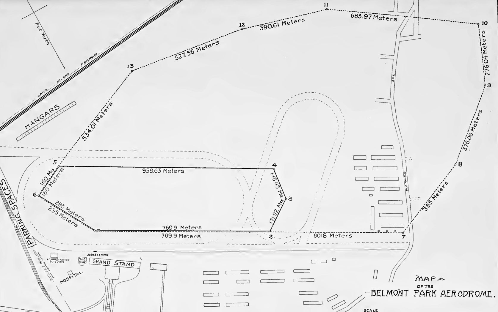
A 1910 map of the Belmont Park Aerodrome (courtesy of Chris Maione).
Long Island's Belmont Park horse racing track was opened 5/4/1905.
In 1910, Belmont Park was used as the site of an International Aviation Tournament.
According to Wikipedia, the airshow was the idea of Andrew Freedman who was a director of the Wright Company, the company started by aviation pioneers the Wright Brothers.
On 8/9/10, the Committee of Arrangements members were announced at the Finance Committee of the Aero Club of America.
The members of the Committee of Arrangements were Alan Ryan, Clifford Harmon and Redmond Cross.
August Belmont was a Wright Company stockholder & he was selected to be the President of the event's organizing committee.
The venue that the committee selected was August Belmont's racetrack at Belmont Park.
They selected Belmont so that they could save money by using the existing stands & they were able to enclose the grounds.
By 10/9/10 the park was being prepared for the airshow. The workers used electric light to work at night. The main grandstand was expanded to accommodate the projected crowds.
The organizers also had to construct hangars for the airplanes, measuring 1,000' long & 15' high.
Aviators began to arrive on October 9 including Frenchmen Alfred Leblanc & Jacques Faure, and American John Moisant.
Thirty aviators attended the 9-day event & the prizes were valued at US$72,300.
Some of the featured aviators included Wilbur Wright, Alfred Leblanc, Émile Aubrun, René Simon, John Moisant and Claude Grahame-White.
The aviation meet was the 2nd international tournament & the contests involved duration, distance, speed, and altitude.
Some of the featured events included the Scientific American Trophy, Michelin Cup, and the Statue of Liberty Flight.
The 100-kilometer Gordon Bennett Cup Race was also a featured competition for the Gordon Bennett International Aviation Trophy & $5,000.
John Moisant crashed twice; the first time he crashed trying out his new Blériot aircraft on October 19.
When he was helped from his plane he said, "Hurt? No, not at all. Nothing ever happens to anybody flying."
Later he had a warmup flight & he crashed second time. The second crash occurred 10/23/10, in Moisant's passenger-carrying Blériot aircraft.
The Associated Press reported that the plane was "badly smashed" & Moisant had to work through the night to complete repairs.
He was forced to search for another aircraft & by the time he had found one, the Statue of Liberty race had already begun.
He found that could not pass the other two competitors so he flew a different route.
James Radley won a race during the event on October 26, covering 20 miles in 19 minutes & 46 seconds, an American speed record.
Moisant won the featured Statue of Liberty race which was a 36 mile trip.
The race began at Belmont, went around the Statue of Liberty & ended back at Belmont, and Moisant won $10,000.
Thomas Fortune Ryan of Bethlehem Steel provided the prize money for the race.
British aviator Claude Grahame-White registered a protest; he had finished second & he wanted to have another attempt.
The show was managed & organized by Aero Corporation Limited. The gate receipts for the show totaled $188,000.
The Wright Brothers were involved with the show & they sued the Aero Corporation over payments they were owed.
William Niles spoke for the Aero Corporation & made claims that the expenses for the show totaled $200,000.
The aviation committee met to discuss Grahame-White's protest. They decided that the contest was over & Moisant had won.
Only three pilots flew in the race, Grahame-White, Moisant and Jacques de Lesseps.
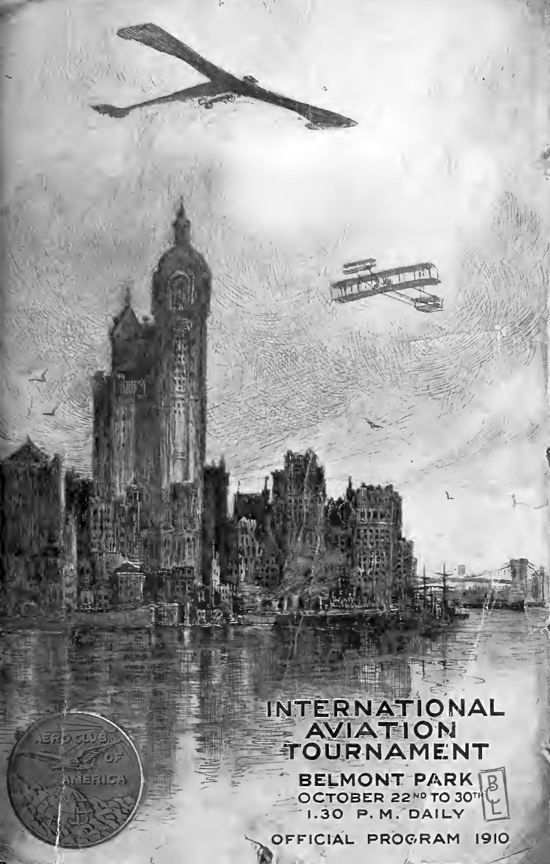
The Official Program of the October 22-30 1910 Belmont Park International Aviation Tournament.
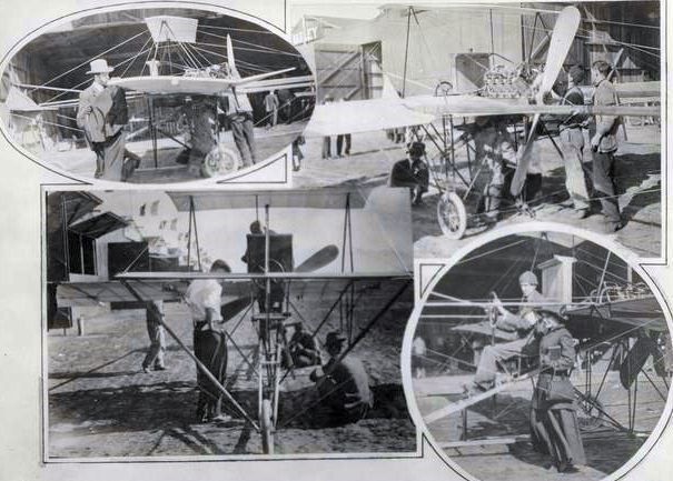
Eugene Ely at the wheel of a Glenn Curtiss monoplane at the Belmont Park International Aviation Tournament in 1910 (courtesy New York Public Library archives).
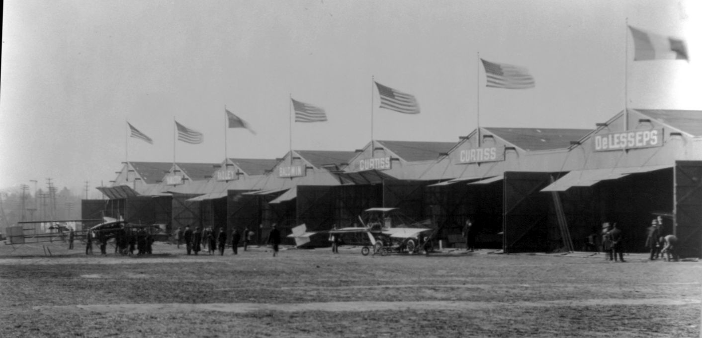
Planes in front of the row of hangars at the October 22-30 1910 Belmont Park International Aviation Tournament (courtesy of Chris Maione).
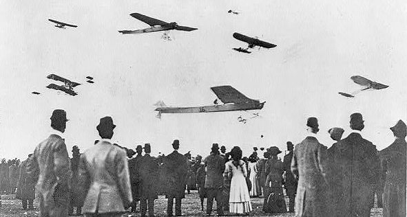
An image of planes over spectators at the 10/30/10 Belmont Park International Aviation Tournament (courtesy of Chris Maione).
In March 1911 (5 months after the contest) the Board of Governors of the Aero Club met & decided to disqualify Moisant because they ruled that he had failed to accomplish a 1-hour flight prior to his entry.
The $10,000 prize was awarded to de Lesseps, not 2nd-place finisher Grahame-White, because Grahame-White had been disqualified when one of his wingtips hit a pylon during the race.
The 1910 meet was presumably the last use of Belmont Park for aviation for several years.
According to Wikipedia, in 1918 Belmont Park was once again used for aviation, when the track served as the northern point of the first U.S. air mail route, between New York & Washington DC.
That was evidently the site's last use for aviation.
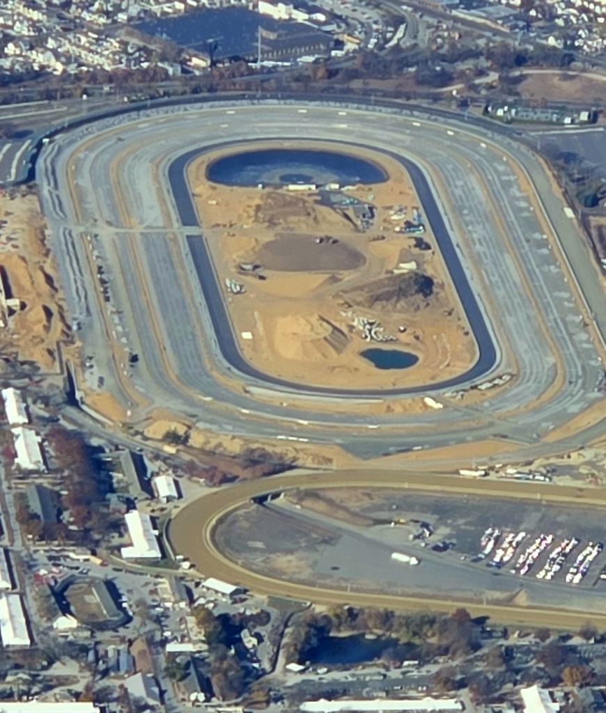
An October 2024 aerial view of Belmont Park (courtesy of Chris Maione).
Thanks to Chris Maione for pointing out this airfield.
____________________________________________________
Island Park Seaplane Base / Suburban Seaplane Base, Island Park, NY
40.596, -73.652 (East of New York, NY)
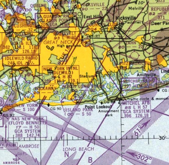
Island Park Seaplane Base, as depicted on the January 1948 NY Sectional Chart.
Island Park Seaplane Base was evidently established at some point between 1947-48,
as it was not yet depicted on the 1947 NY Sectional Chart.
The earliest depiction which has been located of Island Park Seaplane Base was on the January 1948 NY Sectional Chart.
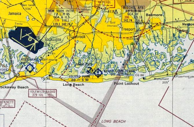
Island Park Seaplane Base, as depicted on the 1953 NY Terminal Chart.
Island Park Seaplane Base was evidently renamed Suburban Seaplane Base at some point between 1953-61,
as that is how it was depicted on the 1961 NY Local Chart.
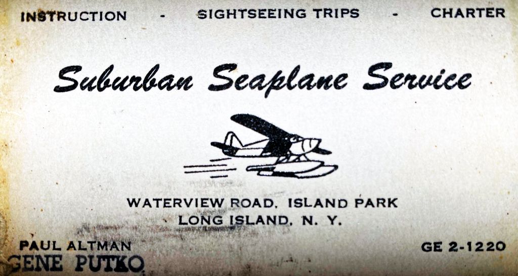
A 1962 business card for Suburban Seaplane Service (courtesy of Bill Wallace) offered instruction, sightseeing tours, and charter.
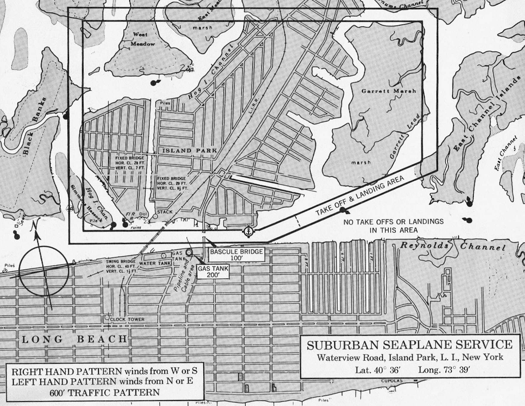
A 1962 traffic pattern chart for Suburban Seaplane Service (courtesy of Bill Wallace).
According to Bill Wallace, “Suburban Seaplane Base was located on Reynolds Channel in Island Park across from the Long Beach Hospital.
I worked there as a line boy / gofer 1962-63 on weekends & during the summers.
The owner/operator was Paul Altman. He had 2 Luscombe 8As with powerful 65hp engines & a Cessna 180.
Other aircraft based there included a Stinson Voyager owned by John DiNapoli, who used to fly charters from Manhattan to Fire Island on the weekends (prior to the bridge being built),
an all-metal Luscombe 8E, a Republic SeaBee owned by an American Airlines pilot, a Piper J-3 and a Piper Tripacer (owned by a newly-retired NYC detective).”
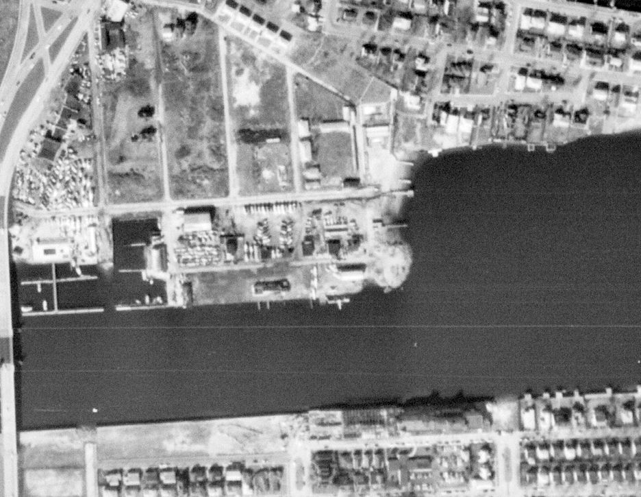
The earliest photo which has been located of Suburban Seaplane Base was a 2/22/62 USGS aerial view,
which showed 4 light single-engine seaplanes at the facility.
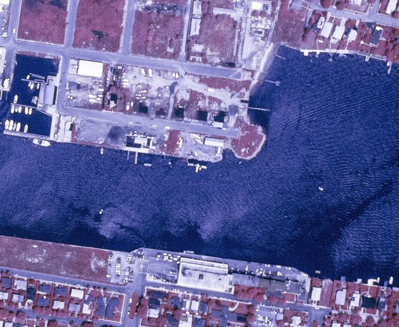
The last photo which has been located of Suburban Seaplane Base was a 7/20/72 USGS aerial view, which showed 3 light single-engine seaplanes at the facility.
The last reference which has been located to Suburban Seaplane Base still in operation was a 7/6/76 NY Times article (courtesy of Bill Wallace), “Seaplane Sinks on L.I. Alter Striking a Boat”.
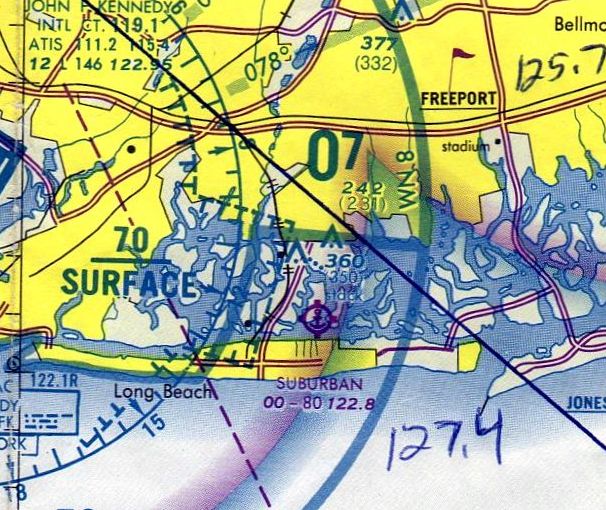
The last depiction which has been located of Suburban Seaplane Base was on the 1982 NY Terminal Chart.
The Suburban Seaplane Base building was still seen in a 1984 aerial view, but there were no longer any planes on the site.
Suburban Seaplane Base was evidently closed (for reasons unknown) at some point between 1982-85,
as it was no longer depicted on the 1985 NY Terminal Chart.
The Suburban Seaplane Base building was still seen in a 2017 aerial view.
A 2019 aerial view showed the Suburban Seaplane Base building had been removed at some point between 2017-2019,
erasing the last trace of this aviation facility.
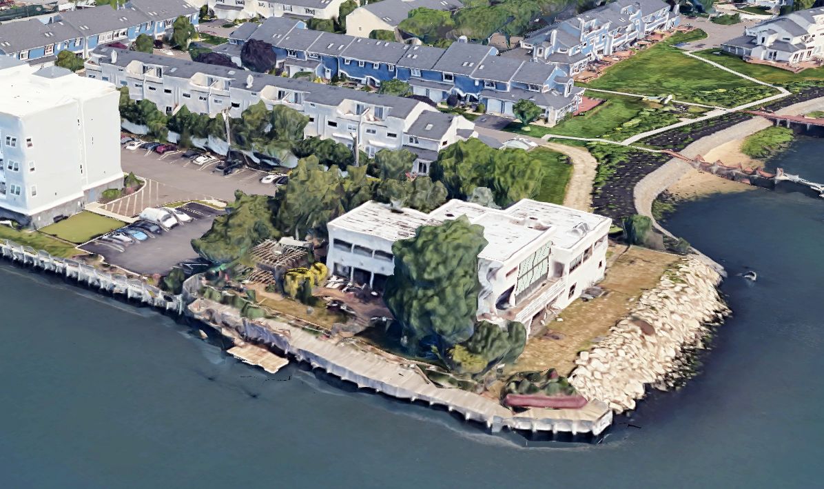
A 2025 3-D aerial image of the site of Suburban Seaplane Base, occupied by a house.
Thanks to Bill Wallace for pointing out this airfield.
____________________________________________________
New York Seaplane Airport / Grumman Seaplane Base / Tom's Point Seaplane Base, Port Washington, NY
40.836, -73.71 (East of New York, NY)

A 1929 photo of the dedication of the New York Seaplane Airport, alongside the factory for the American Aeronautical Corporation in Port Washington.
Pictured from left to right were Edward Warner, B. F. Castle, Enea Bossi, and William MacCracken.
The New York Seaplane Airport was dedicated in 1929.
A photo of the dedication depicted Edward Warner, Former Assistant Secretary of the Navy for Aeronautics, B. F. Castle,
Enea Bossi, Italian-American aerospace engineer & aviation pioneer, and founder of the American Aeronautical Corporation,
and William MacCracken, Assistant Secretary of Commerce for Aeronautics.

A gold plaque commemorating the September 1929 laying of the cornerstone of the New York Seaplane Airport.

A September 1930 – December 1933 photo of Savoia-Marchetti S.56 NC897W flying boat at the New York Seaplane Airport.
The American Aeronautical Corporation, founded by Enea Bossi, produced the S.56 amphibian for the American market at Port Washington.
Enea Bossi also built a stainless steel variant of the S.56 for the Budd company, the BB-1 Pioneer.

The earliest aeronautical chart depiction which has been located of the New York Seaplane Airport was on the November 1931 NY Sectional Chart.

A circa 1930s photo of Enea Bossi, founder of the American Aeronautical Corporation, at the New York Seaplane Airport.
According to Alan Reddig, “The Port Washington facility was right on the waterfront in Manhasset Bay,
and consisted, eventually, of 3 large buildings/hangars with ramps into the bay, with no facilities for land-based aircraft.
It was built by American Aeronautical Corporation, the licensees who built the 3-seater Savoia-Marchetti S.56 in the U.S.
American Aeronautical Corporation declared bankruptcy in 1932.”
 0
0
A circa 1930s photo (courtesy of Alan Reddig) of James Reddig & Allison “Bud” Gillies (Grover Loening’s test pilot) standing in front of Loening’s XSL-2 aircraft,
with the American Aeronautical Corporation hangar at the New York Seaplane Airport in the background.

A circa 1932 photo of X201, the sole example of the Consolidated P2Y-1C Ranger, at the New York Seaplane Airport (courtesy of the Walter Christensen collection).
The P2Y-1C was delivered to the Colombian Air Force in December 1932, and they used it as a bomber in the Colombia-Peru War in 1932–33.
The Port Washington site was sold to Pan Am in 1933.

A circa 1934-40 photo of an under-construction Savoia-Marchetti flying boat at the New York Seaplane Airport (courtesy of the Walter Christensen collection).

A circa 1930s photo looking east (courtesy of the Walter Christensen collection) of 2 Savoia-Marchetti flying boats in front of the southern hangar at the New York Seaplane Airport.

A circa 1930s photo of the 2 NY Seaplane Base hangars; the one on the left belonged to Pan Am & the one on the right to American Aeronautical Corporation.

A circa 1930s artwork by Eric Sloane of the Port Washington NY Seaplane Base hangars (courtesy of Andy Christensen).

A circa 1935-40 photo of the "Lieutenant de Vaisseau Paris", the sole Latécoère 521 flying boat at the New York Seaplane Airport (courtesy of the Walter Christensen collection).
The 521 had 6 engines, with 2 of its engines mounted as tandem pairs behind the inner front engines, facing backward.
It was one of the first large trans-Atlantic passenger aircraft.

A circa 1936-40 photo of Sikorsky S-42B flying boat “Bermuda Clipper” NC16735 at the New York Seaplane Airport (courtesy of the Walter Christensen collection).

A 7/2/37 photo by Rudy Arnold of Pan American Clipper III, Sikorsky S-42B NC16736 C/n 4209, being towed from the New York Seaplane Airport hangar.

An 8/2/37 photo by Rudy Arnold of Cambria, Imperial Airways Short S-23 Empire G-ADUV C/n S.813, on the New York Seaplane Airport ramp.

A circa 1937-39 aerial view looking east (courtesy of Alan Reddig) depicted a Short Empire flying boat moored offshore of the New York Seaplane Airport,
which had 2 large hangars & other smaller buildings.
This particular Short Empire (G-ADUU, Imperial Airways' Cavalier) was lost after a mid-ocean ditching on 1/21/39.
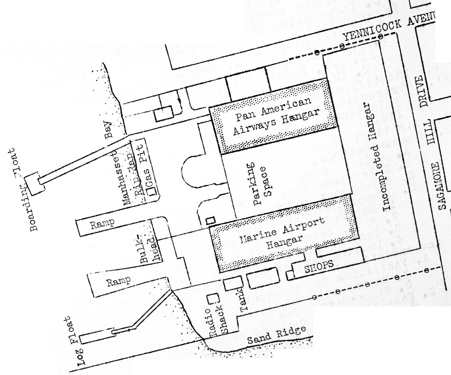
The 1938 Aviation Facilities in NY State (courtesy of Bob Parmerter) depicted the Port Washington Seaplane Base as having a Pan Am Hangar & a Marine Airport Hangar.
According to Alan Reddig, the former American Aeronautical Corporation Port Washington seaplane base was used as a Grumman facility during WW2.

The August 1946 NY Terminal Chart depicted the Port Washington seaplane base as “Grumman”.

The 1947 USGS too map depicted the “New York Seaplane Airport” as 4 buildings with 3 piers on the west side.
At some point between 1947-50, the former NY Seaplane Airport was evidently renamed Tom's Point Seaplane Base,
as that is how it was depicted on the January 1950 NY Sectional Chart.
According to Alan Reddig, the Port Washington seaplane base was used in 1951 as a Republic Aviation facility.

The last aeronautical chart depiction which has been located of Tom's Point Seaplane Base was on the July 1951 NY Sectional Chart.
Tom's Point Seaplane Base was evidently abandoned at some point between 1951-52,
as it was no longer depicted on the January 1952 NY Sectional Chart.

An 11/29/53 USGS aerial view showed the hangars of the former New York Seaplane Airport remained intact,
but there was no sign of any recent aviation use.
A 1974 aerial view showed all 3 hangars/buildings of the former New York Seaplane Airport remained intact.
A 1994 aerial view showed only the northern hangar of the former New York Seaplane Airport remained standing,
with the other 2 hangars/buildings having been removed at some point between 1974-94.
A 2000 aerial view showed the former New York Seaplane Airport property had been scraped clean at some point between 1994-2000,
erasing the last traces of this property's aviation history.

A 2019 aerial view looking north showed the former New York Seaplane Airport property had become densely wooded, in contrast to the dense development surrounding it.
Odd that such a valuable waterfront property would have remained unredeveloped – perhaps pollution concerns from its industrial history have discouraged reuse.
Alan Reddig reported in 2020 of the former NY Seaplane Airport, “It’s now a empty brownfield, in the midst of some of the the most valuable waterfront on Long Island Sound.”
____________________________________________________
Hazelhurst Aviation Field #1 / Curtiss Flying Field / Roosevelt Field, Garden City, NY
40.74, -73.61 (East of Manhattan, NY)

A 1917 photo of a pilot in front of his Curtiss JN-4 Jenny biplane trainer at Hazelhurst Aviation Field #1.
Two airfields, separated by a 15' high bluff, were established here in 1911.
They were collectively known as Hempstead Plains Field.
The 2 fields were taken over by the Army in 1917 & renamed Hazelhurst Field.

"Hazelhurst Aviation Field #1" & "Aviation Field #2", as depicted on the 1918 USGS topo map.

A September 1918 photo of a French Air Force Nieuport 27 N3798 being shown to cadets at Hazelhurst Field.
The US Army Air Service had bought Nieuport 27s for use as trainers.
The Army renamed the east field as Roosevelt Field in 1918.

A remarkable July 1919 photo of the massive British dirigible R34 as it was moored at Roosevelt Field after the first east-to-west nonstop transatlantic flight.

A 1919 photo of the massive British dirigible R34 as it was preparing for its transatlantic departure from Roosevelt Field.

A 1919 photo of one of only 5 Curtiss Model 19 Eagles, seen at Curtiss Field.
The Eagle featured an enclosed passenger cabin & cockpit, but the anticipated postwar aviation boom did not materialize.
The west field was known as Curtiss Field by the 1920s.


A 5/15/21 photo captioned “Opening day Curtiss Flying Field Garden City” (courtesy of Tom Heitzman) showed many spectators & aircraft in front of the row of hangars.

A circa 1920s photo of planes of the Curtiss Exhibition Company in front of the Curtiss Field hangars (courtesy of Ed Das).

A 1922 photo of Bessie Coleman making her 1st appearance in an American air show, at Curtiss Field, Long Island (courtesy of Paul Siwulich).

A 4/30/22 photo of Handley Page O/7 G-EAAF C/n HP-13 at Curtiss Field. The aircraft had been taken over by Curtiss after being impounded.

Roosevelt Field, as depicted on the 1923 New York – Bellefonte Air Navigation Map #3 (courtesy of David Brooks),
along with the nearby Mitchel Field & Hazelhurst Field.

A circa 1923-26 photo of a S-29A (Sikorsky’s first airplane built in America, purchased by Curlee Clothing)
in front of a hangar marked “Sikorsky Manufacturing Corporation” at Roosevelt Field.
The flying activities of Sikorsky were conducted at Roosevelt Field during that time frame

“Government Field #1” & “Government Field #2”, as depicted (the red rectangles) on a circa 1924 Sperry Instruments map of landing fields (courtesy of Tom Heitzman).
In 1925 the Ireland Aircraft Company, specializing in amphibians, was established at Curtiss Field.

A 1926 photo (courtesy of Ed Das) of René Fonck's Sikorsky S-35 Ville de Paris before its takeoff from Roosevelt Field in quest of the $25,000 Orteig Prize that Charles Lindbergh won by flying to Paris 8 months later.

A 9/1/26 photo (courtesy of Allan Reddig) of the cash “in the strip of land between Roosevelt Field & the adjacent Curtiss Flying Field...
when French WWI ace René Fonck unsuccessfully attempted to take off from Roosevelt Field in a modified Sikorsky S-35
in quest of the $25,000 Orteig Prize that Charles Lindbergh won by flying to Paris 8 months later.
Fonck & his co-pilot survived the crash; his navigator & mechanic both perished.
Sikorsky had modified a twin-engined S-35 at Fonck’s request by adding a 3rd engine for the flight to Paris.”

A circa 1926-34 photo of the Wright-Bellanca WB-2 “Miss Columbia” inside a Roosevelt Field hangar.

A circa 1926-28 photo by James Reddig (courtesy of his son Alan Reddig) of a Sikorsky S-29-A at Roosevelt Field.
This Sikorsky, tail # 2756, was painted "First Flying United Cigar Store", had been sold to Roscoe Turner in 1926, who used it to advertise for various companies.
Here it was being used as part of an advertising campaign for United Cigars, in which it was stocked with tobacco products & other small items such as gum, watches, and playing cards.
The airplane flew across the U.S. selling these products in various towns.
It was later bought & reworked by Howard Hughes in 1928 for his film "Hell's Angels" in which it was used as a German Gotha bomber.

A May 1927 photo of Charles Lindbergh & Police Commissioner Abram Skidmore in front of the Spirit of St. Louis & Curtiss Field's Hangar 16.

A 1927 photo of Charles Lindbergh as he prepares to leave from Roosevelt Field for the 1st nonstop solo flight across the Atlantic (courtesy of Paul Siwulich).

A 5/20/27 photo of the preparation of Charles Lindbergh's Ryan “Spirit of St. Louis” for his historic departure
from the eastern portion of Roosevelt Field (Hazelhurst Field) for the world's first solo transatlantic flight.

A 5/20/27 photo of Charles Lindbergh's historic departure from the eastern portion of Roosevelt Field (Hazelhurst Field)
in the Spirit of St. Louis on the world's first solo transatlantic flight.

The 1927 Department of Commerce Airway Bulletin (courtesy of David Brooks) depicted “Curtiss Flying Field” as being located to the west of “Hazelhurst Field”,
and to the north of the Curtiss Aeroplane & Motor Company.
Curtis Field was described as consisting of a 100 acre rectangular property containing a sod flying field measuring 3,000' east/west.
Two rows of hangars were depicted on the west & north sides of the field.

“Aviation Field Curtis Aeroplane & Motor Corp.”, as depicted on a 1927 Hyde road map (courtesy of Kevin Hale),
along with the nearby “Mitchel Field Aviation Grounds U.S Govt.” to the southeast.

A 1927 aerial view looking northeast showing the Curtiss Aeroplane & Motor Company factory in the foreground, and the Curtiss Flying Field in the background.

A June 1927 photo of Fokker C-2 trimotor the “America”, mounted on its dirt launching ramp at Roosevelt Field.
Early on 6/29/27, the "America" took off from Roosevelt Field for Paris, with a crew of 4 under the command of then-Commander Richard Byrd.

A 9/18/27 certificate for James Reddig's airplane ride conducted by Roosevelt Field's Curtiss Flying Service.
Alan Reddig reported, “ In my father’s papers, I’ve come across this ticket stub for a ride for 2 people with The Curtiss Flying Service, Inc., on 9/18/27.
The handwriting of the date is definitely my father’s. This would have been in the fall of his sophomore year in the aeronautical engineering program at MIT.
I do not know who accompanied him on the flight.”

A December 1927 photo (courtesy of Ed Das) of a Sikorsky amphibian which unsuccessfully attempted a flight from Roosevelt Field To Norway.

A 1928 photo (courtesy of Keith Nelson) of Alfred Nelson, unamed pilot, Jack Conkle, Fred Buffa, Don Kunkle, and Bill Keppel in front of a Sikorsky S-38 amphibian at Curtis Field.
Keith Nelcon reported of his father, Alfred Nelson, “We believe he was the youngest licensed mechanic at the time with A&E license #8818 at age 17.”

A 1928 photo (courtesy of Keith Nelson) of Alfred Nelson & Jack Conkle in front of a Sikorsky S-38 amphibian at Curtis Field.

A 1928 photo (courtesy of Keith Nelson) of Eleanor Smith in a Sikorsky S-38 amphibian at Curtis Field.
Keith Nelson reported, “Eleanor was the youngest pilot in the US in 1927 at age 16.
The year this photo was taken, she got in trouble for flying under the 4 bridges that crossed the East River in New York City.
She went on to be named Best Woman Pilot In America in 1930. She set numerous flying records during her career.
She not only set or broke records, she broke barriers women faced in pursuit of equal treatment.”

A 1928 photo (courtesy of Keith Nelson) of a mechanic, Steve Parkinson, Bill Stulz, and an unidentified man in front of a Sikorsky S-36 amphibian at Curtis Field.
Keith Nelson reported, “In addition to Amelia Earhart's pilot in her first Atlantic crossing, Wilmer Stultz (named Bill Stultz in the photo), there is also Steve Parkinson.
Steve helped push Lindbergh's plane at Roosevelt Field on his trans-Atlantic flight in 1927.
The plane is a Sikorsky S-36 named “Dawn”. This plane was owned by Frances Grayson who wanted to be the first woman to fly across the Atlantic.
Stultz was her pilot. They made 2 attempts but they turned back both times. Stultz then quit.
Grayson hired another pilot & with a navigator & radio engineer, took off from Curtiss Field on 12/23/27. The plane disappeared & was never found.”

A circa-1920s aerial view (courtesy of Bill Larkins) depicted a large gathering of Army biplanes near the single hangar of the Hazelhurst Field (east) portion of Roosevelt Field.

A 1928 photo (courtesy of Tom Heitzman) of a collection of biplanes in front of a row of hangars at Roosevelt Field.

An undated photo of 2 Roosevelt Field hangars: Hangar 9 (John B. Rintoul, Frank Steinman, Instrument Training, Taylor-Young Air Planes) & Hangar 7 (Plane Owner's Service).

A circa 1928-30 photo (courtesy of Tom Heitzman) of Russ Simpson's Swallow biplane in front of a crazy-shaped hangar at Hempstead (Roosevelt Field).

A 1929 NY Legislative Report (courtesy of Tom Heitzman) depicted “Curtiss Flying Field” as being located to the west of “Hazelhurst Field”,
and to the north of the “Curtiss Aeroplane & Motor Company” & Mitchel Field – a dense assemblage of aviation.
Curtis Field was described as consisting of a 100 acre rectangular property
containing a sod flying field measuring 3,000' east/west.
Two rows of hangars were depicted on the west & north sides of the field.
According to Peter Maefield's 1972 Wings Club of NYC speech (courtesy of Dave Kanzeg),
“In 1929, before the depression, Roosevelt Field Inc. bought out both Lannin & Curtiss.
The name Curtiss Field was then changed to 'Roosevelt Field Unit 2'.
After that 'Roosevelt Field Unit 1' (East) & 'Roosevelt Field Unit 2' (West) were operated as one unit
connected by an oiled ramp 500' long by 150' wide at the North end of the 12' grade which cut through the 2 units from North to South.”

A 1929 photo of the “Green Flash” Bellanca Type J at Roosevelt Field.

A 1929 photo of an unidentified man in front of the sole example of the Curtiss-Bleecker Helicopter at Roosevelt Field.
The Curtiss-Bleecker Helicopter was designed by Maitland Bleecker & built by Curtiss in nearby Garden City.
It was reputed to have made several brief flights, but it was not pursued due to instability.

A 1929 photo of the French Bernard 191 GR "Yellow bird" in front of the Air Associates hangar at Roosevelt Field (courtesy of Michel Boquet).
According to Michel, “It is in this hangar that, in May 1929, the plane was prepared for its successful transatlantic flight
from Old Orchard Beach (Maine) to Comillas (Spain) on 6/13/29.
The crew members were Assollant, Lefevre and Lotti, plus the young American stowaway Arthur Schreiber.”

A 1929 photo at Roosevelt Field of one of only 3 Curtiss Carrier Pigeon 2s built for National Air Transport.

A November 1929 photo of Strana Sovyetov, Tupolev ANT-4bis (TB-1) URSS-300 at Roosevelt Field. The ANT-4 was the first large metal aircraft built in the Soviet Union.
At least 30 Ireland Neptune amphibians were produced at Roosevelt Field until 1930.

Roosevelt Field, as depicted on the 1930 "Rand McNally Standard Map of New Jersey With Air Trails" (courtesy of Chris Kennedy).

A 1930 aerial view looking west at “Curtiss Field” (courtesy of Amy Bentley),
showing the row of hangars along the west side (one marked “Air Associates”).
At least 7 aircraft were visible on the field, as well as a large number of cars & people.

A 1930 photo of Eddie Schneider landing at Roosevelt Field after completing his transcontinental flight in his Cessna AW “The Kangaroo”.

A 1931 aerial view looking east at Roosevelt Field, showing the long row of hangars on the north side of the field & numerous other buildings.

A 1931 aerial view looking southeast at a group of unidentified Army twin-engine biplane bombers overflying Roosevelt Field,
with Mitchel Field also visible at the top-right.

A circa early 1930s aerial view looking west at the 2 airfields, showing Charles Lindbergh's takeoff route from the eastern portion of Roosevelt Field (Hazelhurst Field),
with the western portion of Roosevelt Field (the former Curtiss Field) visible in the background.

An undated photo by James Reddig (courtesy of his son Alan Reddig), stamped 5/28/32 by the photo-finisher, of the sole example of the Union Aircraft Corporation Magnus-effect aircraft built at Roosevelt Field.
Alan Reddig reported, “These two images were taken by my father when he was Assistant Chief Engineer at Grover Loening Aircraft Company in Roosevelt Field's Building 17.
Instead of wings, this aircraft has 4 chain-driven horizontal rotors, 2 on each side, designed to provide lift by means of the Magnus Effect (the same principle that makes a spinning pitch into a curveball),
in which a spinning object - in this case, a rotor - develops a force - in this case, lift - perpendicular to the direction of air flowing past the object.
Forward movement was provided by 90hp Cirrus engine-driven propeller, and the rotors were powered by two 28 hp Indian motorcycle engines.
In this view, the port-side rotors are spinning, but the starboard rotors are not.”
On the back of one of the photos, James Reddig wrote “A rotor ship (Flettner rotor idea) which buzzed up & down the field here, trying to fly.”
Alan Reddig reported, “The Flettner reference is to aerodynamic rotors developed in the 1920s by German engineer Anton Flettner to exploit the Magnus Effect, and which are still in use on oceangoing vessels to this day.
Multiple online sources describe this experimental aircraft as having been designed by Isaac Popper & John Guest, and manufactured in 1931 by Union Aircraft Corporation of Long Island.”

An undated photo by James Reddig (courtesy of his son Alan Reddig), stamped 5/28/32 by the photo-finisher, of the sole example of the Union Aircraft Corporation Magnus-effect aircraft built at Roosevelt Field.
Alan Reddig reported, “In this photo the rotors are stationary, and one of the motorcycle engines is clearly visible on the side of the fuselage.
Both of the teardrop-shaped gas tanks cannibalized from the motorcycles are visible straddling the cockpit.”
Jame Reddig reported, “In the early 1930s Roosevelt Field saw every manner of intended flying machine appear.
This weirdo counted on the Flettner rotor effect of the two rotors substituted for wings to provide lift and, by differential speed control to each side, for roll control.
It never exhibited any perceptible lift or capability of flight. Test pilot Jimmy Collins would taxi it noisily up & down the runways at the field for $15 per 'test' from time to time.
One day, inside the hangar, one of the rotor spindles broke loose & the spindle thrashed about like a whip, badly damaging the contrivance & seriously injuring a shop mechanic.
The inventor/designer removed it & it was never heard of again.”

The earliest Sectional Chart depiction which has been located of Roosevelt Field was on the August 1932 NY Sectional Chart.

A 1932 photo by John Willmott “of a Lockheed Sirius at the Hangar 5 of the row of new hangars along the north side of Roosevelt Field
when I was thrown out of high school & working for Air Associates at old Hangar 1 on the west end of the field.”

A 1932 photo by John Willmott of “Frank Hawks's Texaco 13 [Travel Air Mystery Ship] in which he made many record flights.
For the age of this picture, 77 years ago & made with a single meniscus Kodak Box Camera, it's not too bad a shot.
During my free time - and in between on errands - I spent time all over the field,
especially Hangar 5 where the exotic planes were & next door where there were seaplanes.”

A 1932 aerial view by John Willmott of Roosevelt Field.
John recalled, “This is what I saw flying Leo Lowe's OX Waco after my 1st solo
and becoming a commercial pilot on my 2nd solo carrying 4 kids on planks in the cut out enlarged front cockpit.
It would carry 2 not-too-over-gross adults & maybe a kid in the lap in that cockpit.
After that, I got to fly a bunch of different ones like the Gypsy Moth.
License? What's a license? Oh, one of those small pieces of paper.
Some guy eventually asked to see mine after someone said I was flying passengers without a license.
I said when? What plane? That one. Oh, you mean thaaaat one.
Well uh uh I flew it solo but likely wouldn't without a license - would I?
Well, I didn't see you do it & if you do I'm gonna haul you off to jail & fine you. YES SIR! Gotcha!”

A circa 1930s aerial view looking east at Roosevelt Field (courtesy of Alan Reddig).
Alan Reddig noted that the photo was annotated by his father James Reddig, “with an arrow indicating the building Grover Loening leased in the early 1930s when he moved his factory out of Manhattan.
Prominent in the upper center of the postcard is the dark ramp connecting 'lower' Roosevelt Field with 'upper' Roosevelt Field.”

A 4/28/32 photo of the collapsed remains of Roosevelt Field Hangar A after a fire.

An undated photo (date-stamped by the photo processor 5/30/32) by James Reddig of the interior of the Loening Aircraft shop at Roosevelt Field (courtesy of Alan Reddig).
Alan Reddig reported, “Here’s my father’s notes on the back of the print:
'Wing assembly at the [Roosevelt Field] shop. Hull inverted on its jig in the background. Note the little wind tunnel on the lockers. Mock-up of pursuit ship right background. CONFIDENTIAL.'
The wing being assembled is for the XS2L-1, a scout biplane prototype for the US Navy.
The 'wind tunnel' refers to a small-scale wind tunnel he built in 1930 for testing airfoils. It’s above the center of the photo, against the wall.
Now it sits across the room from me as I write this. I have a few of the airfoils.
I assume the 'CONFIDENTIAL' notation refers to the mockup of the 'pursuit ship right background', which never came to fruition.
Here we are, 86 years later, so I don’t think there’s any harm in sharing the photo.”

An undated aerial view looking northeast at Roosevelt Field,
from The Airport Directory Company's 1933 Airports Directory (courtesy of Chris Kennedy).

Two undated photos of hangars at Roosevelt Field from The Airport Directory Company's 1933 Airports Directory (courtesy of Chris Kennedy).
The directory described Roosevelt Field as having three 2,000' asphalt runways.
A large number of hangars was depicted along the west & north sides of the field.
The General Manager was listed as George Orr, and dozens of companies were listed as having operations at the field.

A circa 1930s photo of an unidentified man & NC14718, Ireland P-3B Privateer c/n 84, in front of a Roosevelt Field hangar.
Mark Lincoln noted, “The Ireland P-3B first flew in 1933.”

A circa 1933 photo by James Reddig of a Travel Air 6000 at Roosevelt Field (courtesy of Alan Reddig).
Alan Reddig reported that this may have been owned by airline pilot & Brooklyn resident Jack Holst.

A circa 1933 photo by James Reddig of a Cessna DC-6B at Roosevelt Field (courtesy of Alan Reddig).

A circa 1933 photo by James Reddig of an Ireland Neptune N2C amphibian at Roosevelt Field (courtesy of Alan Reddig).
According to Alan Reddig, “Grover Loening closed down his business at Roosevelt Field in 1933.
Fleetwings had a facility at Roosevelt Field, but its business there was limited to the manufacturing of their welding machines (for spot-welding stainless steel)
and fabricating parts for other aircraft manufacturers, including Ireland & Loening.
Someone in the family-owned company got the idea to build a whole amphibious airplane out of stainless steel,
rather than just building parts for other manufacturers, and they hired my father, shortly after Loening closed up shop, to design it.
The move to Bristol was predicated on the need for access to water for flight tests.”
Aircraft manufacturer Fleetwings moved from Roosevelt Field to Bristol Field PA in 1934.

Roosevelt Field, as depicted on the 1934 U.S. Navy Aviation Chart (courtesy of Chris Kennedy).

A Flight Simulator scenery re-creation by Richard Finley of an American Airlines Curtiss Condor overflying Roosevelt Field.
In 1934, Georgian emigre Micheal Gregor founded Gregor Aircraft at Roosevelt Field. Gregor's first product was the 2-seat sport biplane GR-1.

A circa 1935 photo of a Gregor GR-2 in front of the Gregor Aircraft Corporation facility at Roosevelt Field's Hangar B.

A circa 1935 photo of Aline Rhonie painting a huge aviation-themed fresco mural on an interior wall of Roosevelt Field's Hangar F.
According to Peter Maefield's 1972 Wings Club of NYC speech (courtesy of Dave Kanzeg),
“In 1935 Unit 1 [the eastern airfield] was leased for the construction of an automobile race track to replace the Vanderbilt Parkway.”
Curtiss Field was then renamed Roosevelt Field.

A circa 1935 photo of the Roosevelt Field Inn's art deco bar with “Toast to Progress” mural by Eric Sloane.
Aron Krantz recalled of Roosevelt Field, “My dad Duke Krantz was the Daily News pilot there circa 1930-1940 period.”

A circa 1930s aerial view looking northeast at Roosevelt Field.

A 1936 (or later) photo at Roosevelt Field of one of only 5 F-5 Seabird amphibians produced by Fleetwings.
The F-5 was a 5-seater that was produced entirely of spot-welded stainless steel.

An aerial view looking southeast at Roosevelt Field
from The Airport Directory Company's 1937 Airports Directory (courtesy of Bob Rambo).
The directory tagged Roosevelt Field as "The center of commercial aviation in the east."
It was described as having three 2,000' asphalt runways.
The aerial photo in the directory depicted a long row of hangars along the north & west sides of the field.

A number of vintage advertisements for firms based at Roosevelt Field, from The Airport Directory Company's 1937 Airports Directory (courtesy of Bob Rambo).
Many aviation business operated out of Roosevelt Field, including Aeronautical Radio Company, Waco Sales of New York,
Pester's Propeller Service, C. Foley Company, Aero Trades Company, Northern State Airways, and Leech Aircraft.
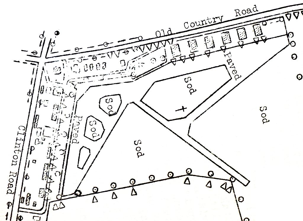
The 1938 Aviation Facilities in NY State (courtesy of Bob Parmerter) described Roosevelt Field as having 3 asphalt 2,000' runways & 20 hangars on the west & north sides.

A 4/10/38 photo of the Roosevelt Field Aero Trades hangar.

A 1939 photo of perhaps the most unusual of the amazing assortment of aircraft built at Roosevelt Field: the sole prototype Koun Aircraft Dirigible Helicopter,
which was built over the course of 5 years by Young Ho Koun (pictured in the cockpit, the first Chinese American to develop an aircraft).
This extremely unorthodox machine featured 2 large wing-mounted boxes filled with compressed helium & a Continental engine which could be tilted vertically.
The CAA gave the aircraft a registration number, but not an experimental certificate.
The sole flight attempt was performed in front of media.
After many failed engine start attempts, the engine was started without the pilot & the vehicle was damaged while securing it.
The aircraft was not publicly displayed again, and was never able to achieve flight.

A 1941 advertisement for the amazing assemblage of aviation businesses at Roosevelt Airport (courtesy of Sparky).

A 1941 photo of the sole prototype of the DeBothezat GB-5 coaxial helicopter in front of the Roosevelt Aviation School hangar.
Soviet emigre Georgi DeBothezat designed & built a series of helicopters under the Helicopter Corporation of America name, and he flew the GB-2 & GB-5 at Roosevelt Field.
Unfortunately their development was ended by DeBothezat's death in 1940.

Langley Aircraft of nearby Port Washington, Long Island, named for aviation pioneer Samuel Langley, built this twin-engine 4-seater of a mahogany plywood composite material in 1941.
Port Washington had no runways & therefore flight tests were conducted 10 miles away at Roosevelt Field.
The Langley's plywood composite material was known as a plastic & therefore it was called a 'plastic plane'.
Ironically, the 'non-strategic' plywood plastic turned out to be scarcer than aluminum.
According to Peter Maefield's 1972 Wings Club of NYC speech (courtesy of Dave Kanzeg),
“Roosevelt Field had shrunk from the original 2-field complex of 700 acres in 1918
to a single field of some 240 acres by the start of the Second World War.
During World War 2 Roosevelt Field was a pilot & ground training center
and also a Modification Center for American aircraft being supplied to the Royal Air Force.
That was its swan song.”

An undated photo of the hangars which may have been at the west end of Roosevelt Field,
from a pamphlet describing the "Roosevelt Aviation School" (courtesy of Bob Levittan),
which apparently trained aircraft mechanics for service during WWII.

An undated business card for the "Roosevelt Aviation School" (courtesy of Andrew McCalla).

A WW2-era National Archives aerial view looking east at Roosevelt Field.

A circa 1940s aerial view looking southwest at Roosevelt Field (courtesy of Ed Drury).
Note the track of the Roosevelt Raceway in the lower left.

A circa 1940s airport layout of Roosevelt Field from an airport directory (courtesy of Ed Drury).
Note the single hangar still depicted on the northern edge of the Roosevelt Raceway property (at the northeast corner of the plan).
Being located near the major aircraft manufacturing facilities of Grumman, Chance Vought, and Eastern Aircraft,
Roosevelt Field was commissioned as Naval Air Facility Mineola in 1943.
Its mission was to serve as a modification & delivery center for newly manufactured aircraft, primarily those purchased by the British.
In 2 & a half years, Roosevelt delivered 6,662 aircraft!

A 1943 aerial view looking southeast at NAF Mineola (Roosevelt Field),
showing the huge number of Grumman & Vought aircraft being fitted out before shipment to the Royal Navy (courtesy of Richard Porcelli).

A circa 1943 photo showing Grumman Martlets (F4F Wildcats) being prepared for the Royal Navy in front of a Roosevelt Field hangar.

A circa 1943-45 photo of a Grumman F6F Hellcat in Royal Navy markings taking off from Roosevelt Field.
At its height during WW2, Roosevelt Field consisted of a total of 3 asphalt runways (the largest was 3,000' long),
parking ramps, 6 large hangars along the northeast ramp, and numerous smaller hangars & other buildings.

A September 1944 advertisement for the Roosevelt Aviation School (courtesy of Richard Finley).
The 1944 US Army/Navy Directory of Airfields (courtesy of Ken Mercer)
described "NAF, Roosevelt" as having a 3,000' hard-surfaced runway,
and indicated that both Army & Navy operations were conducted at the field.
During World War 2 the Dade Brothers factory, adjacent to Roosevelt Field,
which had been a hombeuilder, was contracted by the Army to produce wooden wings & tails for CG-4 troop gliders.
Nearly 1,000 sets were assembled by Dade Brothers with the steel tube fuselages built by General Aircraft in Queens
and crated for overseas shipment at Roosevelt Field.

The 1945 AAF Airfield Directory (courtesy of Scott Murdock) described Roosevelt Field
as a 248 acre irregularly-shaped property within which were 3 asphalt runways, with the longest being the 2,900' northeast/southwest strip.
The field was said to have a total of 8 hangars, with the largest being five 140' x 120' concrete structures.
Roosevelt Field was described as being privately owned, but operated by the Navy & private interests.
After WW2, Roosevelt Field was surrounded by increasingly dense development.

Roosevelt Field was depicted as a commercial/municipal airport on the August 1946 NY Terminal Aeronautical Chart (courtesy of Tim Zukas).

Roosevelt Field was depicted on a 1946 USAAF KS-NY Pilot's Handbook (courtesy of Chris Kennedy) as having 3 paved runways.
Note the proximity of Mitchel Field to the south.

Roosevelt Field & Mitchel Field, as depicted on the 1947 USGS topo map.

An undated aerial view looking northeast at Roosevelt Field from a 1948 brochure (courtesy of Rudolph Tomasik).

Rudolph Tomasik in the front seat of the Roosevelt Aviation School's T-6, “Whistlin Dixie”, from a 1948 brochure (courtesy of Rudolph Tomasik).

Maintenance being performed on the Roosevelt Aviation School's T-6, from a 1948 brochure (courtesy of Rudolph Tomasik).

Rudolph Tomasik of the Roosevelt Aviation School in front of a Republic SeaBee, from a 1948 brochure (courtesy of Rudolph Tomasik).

A 9/1/48 USGS aerial view showed the proximity of Roosevelt Field to Mitchel Field to the south.

An undated aerial view looking west along the northern row of hangars at Roosevelt Field.
The photo is presumably from late in the life of Roosevelt Field (late 1940s / early 1950s?), the eastern-most hangar had already been removed.

The last aeronautical chart depiction which has been located of Roosevelt Field was on the July 1950 NY Sectional Chart.
According to Peter Maefield's 1972 Wings Club of NYC speech (courtesy of Dave Kanzeg),
“Finally, in August 1950 the field was sold to the real estate developers, Webb & Knapp.”
Roosevelt Field was no longer depicted on the December 1950 NY Sectional Chart.
According to Peter Maefield's 1972 Wings Club of NYC speech (courtesy of Dave Kanzeg),
“Flying ended on 5/31/51 on the original site of Mineola 2 Aviation Ground of 27 years previously.
It was a sad end to an historic spot - sad not least, I suspect, to Grover Loening & to his colleagues of the former Aviation Corporation - AVCO -
who had been major stockholders in Roosevelt Field Inc. & had backed it solidly.”

A sad 1950s photo of an abandoned Roosevelt Field hangar, still bearing a proud stylized “R” logo on top.

The last photo which has been located showing Roosevelt Field still largely intact was a 12/2/53 USGS aerial view.
Although redevelopment had begun, most of the runways & some of the hangars still remained intact.
Bill Reidy recalled, “I did quite a bit of flying over Long Island in the 1950s.
Although Roosevelt Field was closed you could still see the outline of the runways.
I always thought of Lindbergh heading for Paris!”
Robert Weiss recalled that "at least one of the Roosevelt Field hangars was a teen nightclub in the mid 1960s -
'Murray the K's World' - a popular NY disc jockey lending his name (and $?) to the place.
I remember going to see Mitch Ryder & the Detroit Wheels there in 1966 or so."
By the time of a 1966 aerial photo, the site of the former airfield had been redeveloped as the Roosevelt Field Mall,
with not a trace of the historic airfield remaining.
According to Peter Maefield's 1972 Wings Club of NYC speech (courtesy of Dave Kanzeg),
“Roosevelt Unit 1 (East) is now Roosevelt Field Industrial Complex & Horse Race Track.
Roosevelt Unit 2 is now Roosevelt Field Shopping Center.
The two are separated by the Meadowbrook State Parkway,
more-or-less on the site of the original ramp between the 2 fields.”

The 1979 USGS topo map depicted numerous buildings covering the west part of the airport site, and Roosevelt Raceway to the east.

As seen in a 2005 aerial photo, not a trace of Roosevelt Field appears to remain.

A 9/18/27 photo by Allan Reddig “of a nugget of melted aluminum my father [James Reddig] dug out of the dirt in the strip of land between Roosevelt Field & the adjacent Curtiss Flying Field.
It is an artifact of the crash & fire resulting when French WWI ace René Fonck unsuccessfully attempted to take off from Roosevelt Field in a modified Sikorsky S-35.
I don’t know when my father dug up the nugget of aluminum.
He worked for Grover Loening in Hanger 17 at Roosevelt Field in the early 1930s, but the ticket stub implies he might have been at the field on any number of occasions during the late 1920s as well.”
The site of Roosevelt Field is located southeast of the intersection of Old Country Road & Clinton Road, less than one mile north of the site of Mitchel AFB.
____________________________________________________
Hazelhurst Aviation Field #2 / Mitchel Field / Mitchel AFB, Garden City, NY
40.725, -73.595 (Southeast of La Guardia Airport)

A 1917 view looking south at a biplane flying from Hazelhurst Aviation Field #2.
During the American Revolutionary War this property was known as the Hempstead Plains & used as an Army enlistment center.
In the War of 1812 & in the Mexican War, it was a training center for infantry units.
During the American Civil War, it was the location of Camp Winfield Scott.
In 1898, in the Spanish–American War, it was known as Camp Black.
This field was established in 1917 as Aviation Field #2 just south of Hazelhurst Field
to serve as an additional training & storage base, part of the massive Air Service Aviation Concentration Center.
Curtiss JN-4 Jennies became a common sight over Long Island in 1917 & 1918.
Hundreds of aviators were trained for war at these training fields, two of the largest in the United States.
Numerous new wooden buildings and tents were erected on Field #2 in 1918 in order to meet this rapid expansion.

A USAAC photo of the “Signal Corps Flying School, Mineola”.
"Aviation Field #2" was depicted as an irregularly-shaped outline on the 1918 USGS topo map, along with nearby "Hazelhurst Aviation Field #1".
Hazelhurst Aviation Field #2 was renamed Mitchel Field in 1918,
after John Mitchel, the youngest elected Mayor of New York City,
who perished in a 1918 crash after joining the Signal Corps Army Air Service.


A circa 1920-23 photo of a rare LWF Model H Owl trimotor mail biplane at Mitchel Field, with its unusual twin-boom configuration.
Lewis Layne was killed in a crash of a Curtis Oriole at Mitchel Field on 6/27/1920 (according to Layne Bumgardner).
On 11/27/20 the Pulitzer Trophy Race was held at Mitchel Field - the race consisted of 4 laps of a 29 mile course.
Thirty-eight pilots entered & took off individually.
The winner was Capt. Corliss Moseley, flying a Verville-Packard VCP-R racer, a cleaned-up version of the Army's VCP-1 pursuit plane, at 157 mph.
In October 1923, Mitchel Field was the scene of the first airplane jumping contest in the nation.
During the same year, two world's airplane speed records were established there.
Mitchel Field, as depicted on the 1923 New York – Bellfonte Air Navigation Map #3 (courtesy of David Brooks),
along with the nearby Roosevelt Field & Hazelhurst Field.
In 1924, the airmail service had its inception in experimental flights begun at Mitchel Field.

A 1924 aerial view looking west at the row of WW1-era hangars at Mitchel Field.
Note the roof of each hangar was painted with 1 letter, together spelling out “Mitchel”.

A 10/12/27 photo of a “Line inspection” in front of a Mitchel Field 61st Service Squadron Engineering Department hangar of a Douglas C-1 biplane transport (courtesy of Ford Lauer).
Bernie Shearon noted, “The lower inscription is 'FAID', which would indicate the plane was assigned to the Fairfield Air Intermediate Depot at Wright Field.”
“Mitchel Field Aviation Grounds U.S Govt.”, as depicted on a 1927 Hyde road map (courtesy of Kevin Hale),
along with the nearby “Aviation Field Curtis Aeroplane & Motor Corp.” to the northwest.

The location & layout of Mitchel Field, as depicted on the 1928 Commerce Department Airway Bulletin (courtesy of David Brooks),

A remarkable 3/10/28 aerial view looking northwest at a snow-covered Mitchel Field (courtesy of Ford Lauer).

A 1929 photo of James Doolittle at Mitchel Field, on the occasion of him becoming the 1st pilot to use only instrument guidance to take off, fly a set course, and land (courtesy of Paul Siwulich).
A 1929 NY Legislative Report (courtesy of Tom Heitzman) described Mitchel Field as a 280 acre rectangular property
having a 4,000' x 3,000' sod landing field.

A 1929 photo of a Curtis Pulitzer Racer at Mitchel Field.
Mitchel Field continued to grow after WW1 & a major new construction program was undertaken from 1929-1932,
to turn the temporary wartime facilities into a permanent Army post,
including the construction of housing, warehouses, operations buildings, and 8 massive steel & concrete hangars.
In September 1929, Lt. James Doolittle made the world's first blind flight.
Mitchel Field, as depicted on the 1930 "Rand McNally Standard Map of NJ With Air Trails" (courtesy of Chris Kennedy),
along with the nearby Roosevelt Field & Hicksville Aviation Country Club Airfield.

A 4/3/30 photo of an inspection of Army biplanes at Mitchel Field. Bernie Shearon noted, “The first 7 from the left appear to be Curtiss Falcon observation planes.”

A 1931 aerial view looking west at Mitchel Field (courtesy of Brett) showed a large number of Army biplanes, and a long row of hangars along the north side of the field.
A plaque was erected in December 1931 “Commemorating the site of Aviation Field #2” by the Daughters of the Revolution.
The earliest Sectional Chart depiction which has been located of Mitchel Field was on the August 1932 NY Sectional Chart.

A circa 1930s aerial view looking southeast at Mitchel Field showed the large number of hangars & other buildings.
The airfield still consisted of an open grass area.

A circa 1931-36 photo of a Keystone B-6A biplane bomber of the 1st Bomb Squadron, 9th Bomb Group, at Mitchel Field.
Mitchel Field, as depicted on the 1934 U.S. Navy Aviation Chart (courtesy of Chris Kennedy).

A circa 1930s aerial view looking east at Mitchel Field (courtesy of George Mihal of the Office of Image Archaeology),
showing several twin-engine biplanes parked in front of the row of checkerboard-roofed hangars.

An aerial view looking west at Mitchel Field from The Airport Directory Company's 1937 Airports Directory (courtesy of Bob Rambo).
It described Mitchel Field as having a rectangular 4,000' x 3,000' grass landing area, plus one 2,700' paved east/west runway.
The aerial photo depicted a line of hangars along the northern edge of the field.

An 8/24/37 photo of Douglas O-46A C/n 1532 36-132 at Mitchel Field.

A 1938 aerial view (courtesy of John Voss) looking north at 2 Army Martin B-10 bombers, which had departed from Mitchel Field on the first nonstop transcontinental bomber flight.
Mitchel Field was visible at bottom-left, and Roosevelt Field was visible in the background at top-left.
Bernie Shearon noted, “The B-10s are assigned to the 9th Bombardment Group (Tail Code BI, B=Bombardment, I=9).
The squadron marking on the nose of the plane on the left looks like the bison of the 99th Bombardment Squadron & the consecutive numbers on the tail indicate both are assigned to the same squadron.”

A 1938 aerial view looking east at Mitchel Field during an American Legion convention.

A May 1938 photo (courtesy of John Voss) of a display of the sole prototype of the Boeing XB-15 bomber at Mitchel Field.
The XB-15 was the largest aircraft constructed in the United States up to that point.
Mitchel Field also served as a base from which the first demonstration of long-range aerial reconnaissance was made.
In May 1939, three B-17s, with Lt. Curtis LeMay navigating, flew 620 miles out to sea & intercepted the Italian ocean liner SS Rex.
This was a striking example of the range, mobility, and accuracy of modern aviation.

A 7/6/39 aerial view depicted Mitchel Field during the construction of 2 large concrete runways.
Note several aircraft parked along the hangars along the north side of the field.

A 7/11/39 aerial view looking north depicted Mitchel Field during the construction of 2 large concrete runways (courtesy of John Voss).
Also note Roosevelt Field in the background at top-left.
On 9/21/39 Mitchel Field was struck by the "Long Island Express" hurricane.
Flooding produced water that was over knee-deep, numerous trees were toppled & the glass was smashed atop the traffic control tower.

A 10/9/39 aerial view showed the pace of construction progress at Mitchel Field,
with a 3rd concrete runway having been added between July-October.

A 9/5/40 aerial view (courtesy of John Voss) showed Mitchel Field to have 3 paved runways, a large number of checkerboard-roofed hangars,
and a dozen aircraft parked outside.

A November 1940 photo of two dozen P-40 fighters on the Mitchel Field flightline.
In 1940 Mitchel Field was the location of the Air Defense Command,
a command charged with the mission of developing the air defense for cities, vital industrial areas, continental bases, and military facilities in the United States.
Later, First Air Force, was given the responsibility for air defense planning & organization along the eastern seaboard.
Under its supervision an aircraft patrol system along the coast for observing shipping was placed into operation.

A 1/10/41 aerial view looking northwest at Mitchel Field, with Roosevelt Field visible in the background.

A 1941 photo of Army North American B-25 Mitchell bombers departing from Mitchel Field on an antisubmarine patrol.

A 12/5/41 1940 photo of a Curtiss P-40B Warhawk fighter being refueled at Mitchel Field.
Bernie Shearon noted, “The plane is assigned to the 8th Pursuit Group (Tail Code 8P P=Pursuit).
By 1941, the Air Corps had run out of letters in the alphabet for coding group numbers & used the group number itself tin its tail markings - for Reconnaissance & Observation units, it used the squadron number.
A number as high as 91 would indicate the plane is probably from the highest numbered squadron in the group (in 1941, the 36th Pursuit Squadron).
The cross in front of the national marking is to show which side the plane was assigned to for an exercise.”
During WW2, Mitchel was the main point of air defense for New York City, equipped with 2 squadrons of P-40 fighters.
Mitchel Field was a major source of supply in initial garrisoning & defense of North Atlantic air bases in Newfoundland, Greenland, and Iceland.
From the airfield the planning for the air defense of Nova Scotia & Newfoundland was conducted.
Antisubmarine patrol missions along the Atlantic coast were carried out in 1942 by the United States Army Air Forces Antisubmarine Command aircraft based at Mitchel.
Under the direction of the First Air Force, Mitchel Field became a command & control base for both I Fighter & I Bomber Command.
Tactical fighter groups and squadrons were formed at Mitchel to be trained at AAF Training Command bases
(mostly in the east & southeast) before being deployed to the various overseas wartime theaters.
Additionally, thousands of Army Air Force personnel were processed through the base for overseas combat duty.


A photo (courtesy of Joe Skaptason), captioned “Simple cut-out aircraft decoys being tested at Mitchel Field, NY, 2/23/43.
These decoys cast a partially credible shadow, but they were obviously flat & unreal.”
Joe Skaptason recalled, “During the war the Army camouflaged many facilities & built fake sites that were close to the originals but could be confused from the air.
Mitchell Field had its fake twin to the southeast of the real base.
I am positive that this is the EXACT spot where we played!
It had changed some by the late 1940s but the P-40 decoys where still identifiable.
The large decoy & shadow in the center were gone as were most of the structures but I remember the rest.”
I question if there was an actual decoy airport as I didn't see it but just recall local adults telling me about the decoys to lead the German bombers away from Mitchell.
During 1943, Mitchel Field became a staging area for Consolidated B-24 Liberator bombers & their crews before being sent overseas.

A circa 1940s colorized photo of twin-engine military trainers on the Mitchel Field ramp.

An April or May 1943 photo by Robert Richie of a tail gunner in a Boeing B-17 Flying Fortress bomber at Mitchel Field
The 1944 US Army/Navy Directory of Airfields (courtesy of Ken Mercer)
described "Mitchel, Army" as having a 5,400' hard-surfaced runway.

A Flight Simulator scenery re-creation by Richard Finley looking northwest at Mitchel Field, with Roosevelt Field at the top-left.
Richard noted, “It is amazing those airports could coexist in such close proximity.
When I went on a house hunting trip with my wife for my job at New York Tracon, we stayed at a hotel built on the old Mitchell Field site.
We arrived at night. I got up the next morning & looked out the window of our room and said, 'My God! Those are hangar buildings over there.'
I had no idea we were staying on a historical airport site where Jimmy Doolittle had flown the first instrument approach
and where the first airplane to make air-to-ground radio contact departed.”

A 1945 aerial view looking west at Mitchel Field (courtesy of John Voss).

The 1945 AAF Airfield Directory (courtesy of Scott Murdock) described Mitchel Field
as a 1,420 acre square property within which were 4 concrete runways, with the longest being the 5,400' northwest/southeast strip.
The field was said to have a total of 11 hangars, with the largest being eight 200' x 110' brick & metal structures.
With the end of World War II, returning GIs were processed for separation at Mitchel.

A circa 1945-50s photo of a Lockheed P-80 Shooting Star jet fighter at Mitchel Field.

A 1946 USAAF KS-NY Pilot's Handbook (courtesy of Chris Kennedy)
depicted Mitchel Field as having 4 paved runways, with the longest being the 5,152' Runway 12/30.
In March 1946, the headquarters of Air Defense Command was established at Mitchel Field.
Joe Skaptason recalled of Mitchel Field's decoy to the southeast,
“Following the war (circa 1946/1947) the fake field was enclosed by barbed wire with many no trespassing federal property signs.
The field had dugouts, fake building & wood & canvass P-40s.
That was a FUN place to play & in spite of rumors & warnings we never saw any MPs.
I think it was in Uniondale to the southeast of Front Street & Meadowbrook State Parkway.”
Joe continued, “I do remember (in what was our play area) the wood & canvas structures were in really poor shape.
There was one fascinating area that was underground. There were 2 wood stairways leading down to an octagonal-shaped room.
The room had benches on 6 walls (3 each on either side of the stair openings). In the middle of the room was a bench that one could stand on.
It was directly under an astrodome - a full Plexiglas navigators canopy. We speculated on its use.
Air raid shelter, guard house lookout, navigational training for star sights. etc? Never did find out.”
Paul Hawthorne recalled, “I lived across the street on the Hofstra College campus from 1946-53.
Lots of C-119s a minute or two apart in the evening,
and F-84s often doing extended runup at the end of Runway 5 in the day.
I figured out years later these were probably just-delivered aircraft & the ferry pilots were making sure the bird was ready.
Runway 18/36 was closed before I got there, courtesy of the wartime crash into the college.
I remember several crashes including a C-119 that just cleared Hempstead Turnpike
and crashed into & burned at Havendale Real Estate one evening, right off the end of Runway 23.
A prop blade fell through the roof of one of the temporary faculty housing units (barracks) & landed on a bed.”
Mitchel served as the headquarters of the Continental Air Command starting in 1947.

Mitchel Field, as depicted on the 1947 USGS topo map.
Mitchel Field, as depicted on the 1:24,000 1947 USGS topo map.
With the establishment of the United States Air Force as a separate service in 1947, Mitchel Field was redesignated as Mitchel Air Force Base.

An undated aerial view from the 1948 “This Is Mitchel AFB” (courtesy of Ron Plante)
depicted a large number of transport aircraft on the north side of the field.
A 9/1/48 USGS aerial view showed the proximity of Mitchel Field to Roosevelt Field to the north.

A diagram from the 1948 “This Is Mitchel AFB” (courtesy of Ron Plante) described the buildings along the flight line.

An undated photo from the 1948 “This Is Mitchel AFB” (courtesy of Ron Plante) of the Base Operations Building.

An October 1948 photo of Northrop P-61B Black Widow night fighters of the 2nd Fighter Squadron (All Weather) on the Mitchel ramp.
By 1949, Mitchel was relieved of the responsibility for defending New York City because
of the many problems associated with operating tactical aircraft in an urban area.
From 1949-61, the Air Force Reserve's 514th Troop Carrier Wing was the main operational flying organization at Mitchel AFB,
flying Curtiss C-46 Commandos.
In 1949, the reserve mission was assigned to First Air Force, which was also headquartered at Mitchel AFB.
First Air Force became the command & control organization for supervising the training of the Air Reserve in 15 eastern states & the District of Columbia.
The July 1950 NY Sectional Chart depicted Mitchel AFB as having a 5,700' paved runway.

A 1950 photo of exotic North American F-82 Twin Mustang night fighters at Mitchel Field.
Joe Skaptason recalled, “I grew up in Hempstead & attended California Avenue grade school until spring of 1951 when I went on to Hempstead High.
I was there until we moved in the summer of 1953. The grade school is still there & at the time it bordered the south side of some athletic fields of Hofstra.
There were many fewer building at that time. We had a much better view to the north toward Mitchell.
I was an airplane nut & spent many hours watching the flights in & out of Mitchel Field.
In the 1949 incident I was on the school baseball field at the grade school in the outfield when I heard a funny sounding engine noise.
This was followed by a crash (we more felt it than heard it).
I looked up (looking to the northwest) to see what turned out to be one of the props of the F-82 slowly rotating upward before it arched over and descended towards us.
We later found out from our Scoutmaster who was a volunteer fireman in Hempstead that the Twin Mustang lost an engine at about liftoff,
went through the fence & into a newly completed but as of yet unoccupied real estate office.
One of the pilots was able to clear his canopy & cross over to the other fuselage & manually release the canopy of the other pilot.
He got him out with minor burns. This made a big impression on me & to this day I can still picture the prop in its rise & fall.”
Joe continued, “We lived at the corner of Lincoln Road and Leverich in Hempstead.
This is just to the right of the centerline of Runway 5 & about 1,200 yards from the threshold.
One day under condition of very low minimums a B-25 broke out of the clouds,
grazed the chimney of the house across the street & crashed into an empty lot about three blocks over.
I think it was Beverly street. The B-25 was totally demolished but there was relatively little damage to the house that surrounded the crash site.
It was surmised that at the last instant the pilot put the bird into the tiny space.”
Mitchel Field was the terminus for the last speed record set on Long Island,
a transcontinental speed record of 4 hours, 8 minutes set by Col. W. Millikan in an F-86 Sabre on 1/2/54.
Mitchel Field's 514th Troop Carrier Wing replaced its Curtiss C-46 Commandos in 1954 with Fairchild C-119 Flying Boxcars.

A 1954 photo by William Ebert (used by permission of Colin Ebert)
of a massive Convair B-36 bomber at Mitchel Field's Armed Forces Day airshow.

A 1954 photo by William Ebert (used by permission of Colin Ebert)
of a Lockheed F-94 Starfire interceptor at Mitchel Field's Armed Forces Day airshow.

A photo of a Vought F7U Cutlass at Mitchel Field's 1954 Armed Forces Day airshow,
from the program of the 5/22/55 Mitchel Armed Forces Day airshow (courtesy of John Stanford via Lisa Stanford).

The 1955 USGS topo map (courtesy of John Voss) depicted Mitchel's airfield at its ultimate configuration,
with 4 paved runways (the longest was the 6,700' Runway 5/23) & a large number of taxiways & ramps.

A 5/21/55 photo of CA Air National Guard North American F-86A Sabre 49-1046 C/n 161-40 at Mitchel Field.
CA ANG Lt Jack Conroy flew from Van Nuys, CA, to Mitchel Field & back in 11 hours 26 minutes total elapsed time, making 2 refuelling stops eastbound & 3 westbound.

A 1957 USAF map (courtesy of Joe McCusker) depicted Mitchel Field as having 4 paved runways, numerous hangars, taxiways, ramps, and dispersal pads.

A circa 1950s-60s aerial view looking southeast at Mitchel Field, with only 2 aircraft visible on the extensive ramp.

An aerial view looking north at the static display of numerous military aircraft on Mitchel's ramp
during the base's 1959 Armed Forces Day open house.

A 1960 photo of C-119 Flying Boxcars from the 514th Troop Carrier Wing
being readied for takeoff from Mitchel AFB during Operation Bright Star / Pine Cone III.

The last aeronautical chart depiction which has been located showing Mitchel AFB in operation was on the 1961 NY Local Aeronautical Chart (courtesy of Mike Keefe).
It depicted Mitchel AFB as having 4 paved runways, with the longest being 6,700'.
After several notable crashes (including a P-47 into Hofstra University’s Barnard Hall), public pressure ultimately led to the field’s closure.
The last active unit to be based at Mitchel was the 514th Troop Carrier Wing flying Fairchild C-119 Flying Boxcars.
The 4 runways of Mitchel AFB were still depicted on the January 1961 NY Sectional Chart, but the field was labeled "Closed".
Mitchel's control tower was vacated on 4/15/61, after 43 years of flight operations at this historic airfield.
The property was eventually turned over to Nassau County.

An undated photo of Mitchel's control tower, shortly after it was vacated in 1961.

A 3/8/66 showed the massive airfield to remain largely intact,
although construction was underway on 2 towers on the southwest corner of the runways.

A 6/3/66 aerial view of Hofstra University construction with the Mitchel Field runways & hangars in the background (National Archives photo, courtesy of Ron Plante).

The 1968 NY Local Aeronautical Chart (courtesy of Tim Zukas) still depicted the 4 paved runways of Mitchel AFB,
but indicated that the field was closed.

A circa 1968 aerial view looking west at Mitchel Field.

A still from the 1972 movie 'The Godfather', for which a vintage tollbooth was constructed on Mitchel Field's abandoned Runway 5/23.
Mike L. recalled, “The northeast portion of Runway 5/23, the extended section with the added access road that's now on the campus of Nassau Community College,
was the filming location for the infamous tollbooth scene in the [1972] movie 'The Godfather'.
In the scene, the cars drove up the runway & made that left turn onto the access road, which is where the tollbooth set was built... just right around the bend.
In the film, there were white, curving tollbooth lane lines painted on the tarmac surface; these lane lines were actually still visible there until recently [2012],
when construction was done in the area (or might have been removed for the Goodwill Games).
Also, in the background of the scene in the film, you can see the radio tower that is on the campus of Bishop Kellenberg High School.
I attended Hofstra University in the early 1990s.
I lived in a dorm situated on the old tarmac at the south end of Runway 18/36.
At the time, much of the old tarmac surface was still intact & easily recognizable.”

An undated photo of a hangar at Mitchel, which no longer stands.

View of the remaining portion of Runway 23 in 1998.

The remaining hangar line at Mitchel Field, as it existed in 1998.
The Nassau Community College now covers most of the Mitchel AFB site, with portions of 2 runways still remaining.
A new museum has been established on the grounds of Mitchel AFB, the Cradle of Aviation Museum.

A 2003 aerial view by Stephen Cohen looking southwest along the remains of the runway at Mitchel Field.

A circa 2001-2005 aerial view looking west at the remaining line of former hangars from Mitchel Field.

A circa 2001-2005 aerial view looking east at the remaining line of former hangars from Mitchel Field,
with several aircraft from the collection of the Cradle of Aviation Museum visible in the center.

A 2005 photo by Tom Lenihan of Mitchel Field's Hangar 3, after its recent renovation.
It serves as the Cradle of Aviation Museum's “Donald Everett Axinn Air & Space Museum Hall”.
Mike L. reported in 2012 of the runway segment used for filming a scene from 'The Godfather':
“I was at the location recently; they are doing a lot of parking lot work & other construction there now.
It seems as if that remaining section of the runway might be obliterated soon, unfortunately.”

A 2013 photo by Steve Rocketto of the sign commemorating Mitchel Field, with Hangar 3 in the background.

A 3/1/14 photo by Richard Flagg of Mitchel Field's Hangar 2, reused as the Nassau County Firefighters Museum.

An 8/12/14 photo of a Mitchel Field hangar which awaits restoration.

A 3/26/17 photo by Ron Plante of a Grumman OV-1D Mohawk (built right down the road in Bethpage) in front of Mitchel Field Hangar 3 at the Cradle of Aviation Museum.

A 3/26/17 photo by Ron Plante of a Grumman E-2C Hawkeye (built right down the road in Bethpage) at Mitchel Field's Cradle of Aviation Museum.
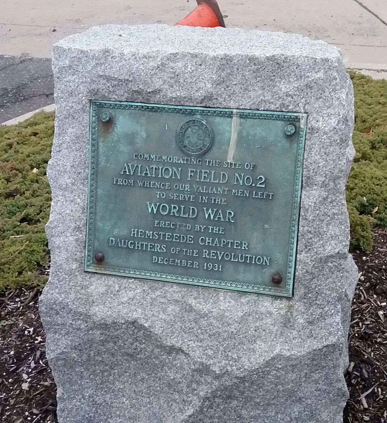
A 3/26/17 photo by Ron Plante of a plaque erected in December 1931 “Commemorating the site of Aviation Field #2” by the Daughters of the Revolution.

A 2018 photo of the plaque situated that year that commemorated Mitchel Field's addition to the National Register of Historic Places.
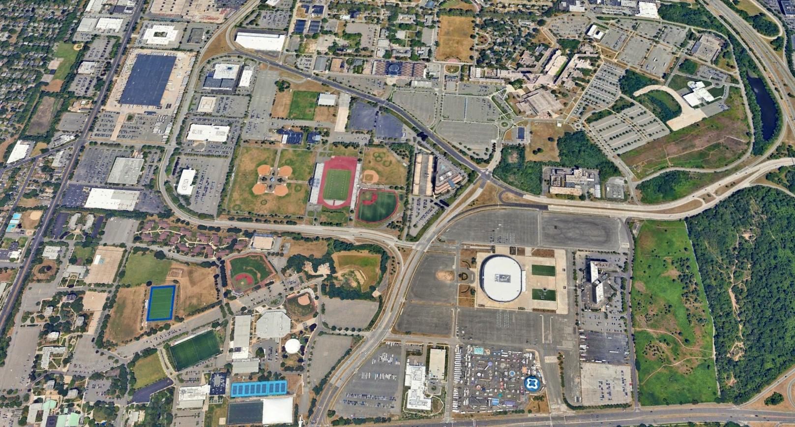
A 2023 aerial view looking northwest at the Mitchel Field site showed the last remaining portions of Runway 5/23 were visible in the NE & SW corners.
See also:
http://pirs.mvr.usace.army.mil/fuds/C02NY064503/21.pdf
http://www.hnd.usace.army.mil/OEW/factshts/factshts/mitchel.pdf
________________________________________________
Advance Sunrise Airport / Curtiss Airport / Columbia Aircraft Company Airfield, Valley Stream, NY
40.66, -73.724 (East of JFK Airport, NY)

A 1929 aerial view looking northeast at Curtiss Airport in Valley Stream (courtesy of Amy Bentley).
The history of this obscure little airport is somewhat convoluted, and involves 2 obscure aircraft manufacturers which made their home at Valley Stream.
According to Amy Bentley, Advance Sunrise Airport was opened in 1928 on leased land of the Reisert farm.
The airport was operated by Advance Aircraft Corporation, of which Francis Rogers was the president of the company.
In 1929, Curtiss-Wright purchased the Advance Sunrise Airport property.
Several millions of dollars were invested before the Curtiss Airport became operational.
Hundreds of planes used the facility daily, along with famous aviators like Charles Lindbergh & Wiley Post.
The earliest photo which has been located of Curtiss Airport in Valley Stream was a 1929 aerial view looking northeast (courtesy of Amy Bentley).
It depicted Curtiss Airport as having 2 asphalt runways in a triangular layout in the middle of a large grass field, with a row of 6 substantial hangars along the west side,
and a 7th hangar on the northeast side.

The earliest aeronautical chart depiction which has been located of the Valley Stream Curtiss Airport
was on the 1929 Washington-NYC Air Navigation Map #3.
The Ninety-Nines, an international organization of licensed women pilots,
was established on 11/2/29, when 26 licensed women pilots met at Curtiss Airport in Valley Stream.
The group was named for the 99 charter members.
According to Chrystopher Spicer, one of their charter members was Jessie "Chubbie" Miller, who had been the first woman to travel by air from England to Australia.
“Her main airfield in the U.S. was the old Curtiss Field at Valley Stream.”
Curtiss Airport was the largest commercial airport on Long Island for 3 years starting in 1930.

A circa 1930 aerial view looking northeast depicted Curtiss Airport as having 2 asphalt runways in a triangular layout in the middle of a large grass field.
A row of 6 substantial hangars lined the west side of the field, and a 7th hangar was located on the northeast side.

A circa 1930s aerial view looking east at Curtiss Wright Airport (courtesy of Lowell Scott), possibly taken during the same event as the preceding photo,
showings a mass gathering of biplanes on the northeast side of the field, with the Curtiss hangar visible on the left.

A circa 1930s aerial view looking south at the northeast side of Curtiss Wright Airport (courtesy of Lowell Scott),
showings a large number of aircraft, and the Curtiss hangar at bottom-right.

Curtiss Airport in Valley Stream, as depicted on the 1930 "Rand McNally Standard Map of NJ With Air Trails" (courtesy of Chris Kennedy).

The 1930 Geographia Map of Queens depicted “Curtiss Field” as an irregularly-shaped property outline.
The Valley Stream Airport was also the location of Naval Reserve Aviation Base Valley Stream
(according to the 12/50 issue of the Naval Aviation News (courtesy of John Voss).
As of 1930, the naval aircraft assigned to NRAB Valley Stream were 6 Consolidated NY-2s, 1 Vought O2U-2, and 3 Curtiss Fledgings.
Training was given to 3 squadrons, and during the summer elimination flight training was provided to 35 student flight officers.

A 5/7/30 photo (courtesy of Mark Hess) depicted a large number of biplane amphibians & landplanes at Curtiss Airport.
The photo was captioned: “Planes at Curtiss Airport, lined up for their descent upon Manhattan.
Curtiss Airport, Valley Stream: Some of the 152 fighting, scouting, bombing, and torpedo planes which participated in the sensational aerial salute to Manhattan today.
The planes are drawn up at the Curtiss Airport, Valley Stream, in readiness to take off.
From noon until nearly 1PM the shiny-winged birds swooped & soared over the city while excited citizens dropped their work to witness the thrilling spectacle.”

A circa 1930 photo of 4 planes in front of a Curtiss Wright Flying Service hangar, apparently on the northeast side of Curtiss Airport Valley Stream.

A 7/13/30 photo of Frank Hawks arriving at Valley Stream in his Travelaire after setting a new transcontinental speed record.
At some point after 1930 Valley Stream's Naval Aviation activities was transferred to Floyd Bennett Field.

The sole prototype of the bizarre Curtiss-Bleeker helicopter, seen in 1930 at the Curtiss airfield in Valley Stream.
According to the Cradle of Aviation Museum, In 1931, Leroy Grumman's fledgling aircraft company was outgrowing its tiny shop in Baldwin,
and “a vacant Naval Reserve hangar was discovered adjacent to Curtiss Field in Valley Stream.
Compared to the Baldwin shop, the hangar was quite satisfactory, and the rent was very reasonable.
Alongside the hangar was a small building that would house the engineering department & the corporate offices.
In late 1931 Grumman's prototype XFF-1 Navy fighter was moved by truck to Grumman's new facility at Curtiss Field in Valley Stream.”
Grumman’s move to the new accommodations was made on 11/4/31.
It took 3 days to truck everything over & set up shop.
When the incomplete XFF-1 arrived at the hangar, work resumed at the former hectic pace.
A few weeks later, the expected contract for the Model B floats arrived, an early Christmas gift from the Navy.
Things were rapidly winding up to a climax. With each passing day, the XFF-1 was closer to being ready for its first flight.
Tension & excitement mingled as the last work was completed on the new fighter.
It was time to see if the efforts of the past nine months would be rewarded.

A 1931 photo of the prototype XFF-1 fighter outside Grumman's new Curtiss Field facility.
According to the Cradle of Aviation Museum, “In the freezing cold morning air of 12/29/31, the XFF-1 was rolled out of the hangar into the morning sun.
Carefully, the fighter was subjected to an intensive pre-flight inspection.
Once everything had been checked, re-checked and then triple-checked, it was deemed ready to fly.
Test pilot Bill McAvoy climbed aboard. With the engine started, McAvoy went through his checklist & taxied to the end of the grass field.
After a magneto check, McAvoy eased the throttle forward & the new plane surged down the field & eased off the ground.
Cranking the landing gear wheel, McAvoy pulled up the wheels.
This first flight was supposed to last more than 2 hours, but within 30 minutes, the XFF-1 was back.
Since there was no radio, no one understood why the flight had been aborted. McAvoy landed & taxied over the hangar.
At first glance it was obvious that something was very wrong. Streaked in oil, the fighter braked to a stop in front of the open hangar door.
As soon as the engine was shut down, Grumman mechanics swarmed all over the little biplane.
In a matter of 2 minutes, the problem had been discovered. The filler cap on the oil tank had not been properly secured.
Under pressure, oil was blown out and it covered the fuselage & the cockpit glass.
After cleaning the oil from the plane & topping off the oil tank, the cap was fastened securely & McAvoy took off again to finish the test flight.
After being successfully tested by Grumman, the XFF-1 was turned over to the Navy for acceptance testing.”
According to the Cradle of Aviation Museum, “While the Navy continued testing of the XFF-1,
Grumman was busy constructing the XSF-1, which would fly in August, 1931.
Shortly thereafter, the Navy awarded Grumman with a contract to build the XJF-1 Amphibian prototype.
By the end of the year, the Navy accepted the XFF-1 & issued a contract for 27 FF-1 fighters.
With contracts in hand totaling nearly $750,000, Grumman was in the aircraft business for the foreseeable future.
Ultimately, 34 SF-1 Scout fighters would also be ordered.
Soon, work would begin on the XJF-1 & once again, Grumman would outgrow its facility, relocating to Farmingdale.”

Curtiss Field in Valley Stream, as depicted on the August 1932 NY Sectional Chart.
In 1933, only 3 years after the Curtiss Airport had opened in Valley Stream,
the worsening conditions of the Depression reportedly led to the airport's closure.

A 1935 aerial view looking northeast at Curtiss Field in Valley Stream, showing the row of 6 hangars along the west side of 2 paved runways.

A November 1940 aerial view looking northeast at Curtiss Field in Valley Stream (courtesy of Jim Freyler).
The airfield consisted of 3 asphalt runways in a triangular layout in the middle of a large grass field.
A row of 6 substantial hangars lined the west side of the field, and the Curtiss hangar remained on the northeast side of the field.
Jim noted, “There were still 5 aircraft parked there in the photo although the field had been 'closed' for many years.”

A circa 1940 aerial view looking south along the row of 6 hangars at Valley Stream (courtesy of Richard Porcelli).
According to Amy Bentley, in 1941 the Columbia Aircraft Company moved from Hempstead to Valley Stream.
John Hehir recalled, “I grew up in Green Acres in the early 1940s.
I remember going with my mother to pick berries which grew between the runways.
We had to watch out for planes, mostly biplanes, which taxied on the runways. My mother was a Red Cross volunteer & did some volunteer work there.”

A J2F-6 Duck, built by Columbia Aircraft in Valley Stream, NY.
During WW2, the Grumman Aircraft Company (in nearby Bethpage) developed the J2F Duck floatplane.
However, under pressure of growing demand for its more urgently needed fighters & dive-bombers,
Grumman had to farm out the Duck & other projects.
After the last J2F-5 Duck rolled off the Grumman assembly line,
production of the Duck was shifted to the Columbia Aircraft Corporation,
which built the J2F-6 at their Valley Stream, Long Island factory starting in early 1942.
The J2F-6 was identical to the -5 except for the more powerful Wright 1820 Cyclone engine (with 1,050 hp).
Lee Englund recalled, "As a kid I lived in Valley Stream in the 1940s. It was great fun to watch the Grumman Ducks flying around."
The Columbia Aircraft Company airfield was not depicted at all on the 1943 NY Sectional Chart (according to Chris Kennedy).
According to John Voss, the Columbia airfield was listed in the 1944 Directory of Airfields, with a 2,900' runway.
A total of 330 J2F-6 Ducks were produced in Valley Stream for the Navy & Coast Guard by the time production ceased in 1945.

The 1945 NY Sectional Chart (courtesy of Robert Brown) depicted Columbia as an auxiliary airfield.

The 1945 AAF Airfield Directory (courtesy of Scott Murdock) described Columbia Airport
as a 218 acre irregularly-shaped property within which were 2 macadam runways, measuring 2,880' NNE/SSW & 2,850' NNW/SSE.
The field was said to have a total of 8 cinder block & wood hangars, with the largest measuring 266' x 123'.
Columbia Airport was described as being owned by the Defense Plant Corporation & operated by private interests.

An undated photo of the ungainly Columbia XJL-1 amphibian.
An even more obscure product of this relationship was the XJL-1.
During the early WW2 years Grumman commenced a project to marry the best features of the Duck
with a more modern monoplane configuration, an all-metal structure, and fully retractable tricycle landing gear.
This resulted in the XJL-1, which was also farmed out to Columbia Aircraft Company.
Columbia built 3 prototypes of the XJL-1.
One prototype was tested structurally to destruction, while the first to fly took to the air in late 1946.
The specific outcome of the XJL project is unknown, but it evidently was canceled as part of the post-WW2 military cutbacks.

The August 1946 NY Terminal Aeronautical Chart (courtesy of Tim Zukas) depicted Columbia as an auxiliary airfield.
Columbia Aircraft Company was acquired by Commonwealth Aircraft in 1946.
Commonwealth transferred production of their Skyranger (a light single engine general aviation aircraft)
from Kansas City's Fairfax Airport to the former Columbia Aircraft factory in Valley Stream.
Commonwealth went on to manufacture 276 of their Skyrangers before production ceased after less than one year, in late 1946.
According to Sam Berliner, “Circa 1946-50, along with Bulova, one or more of the hangars at Rogers-cum-Curtiss-cum-Columbia-cum-Green Acres in Valley Stream
was home to my classmate's father's & uncle's Studley Paper Company.
They made Kraft paper set-up boxes, vacuum cleaner bags, and such.”
Commonwealth Aircraft went bankrupt in 1947, as the anticipated post-war boom in civil aviation never occurred.

Columbia Airport, as depicted on a 1947 USGS map.

The 1:24,000 1947 USGS map depicted Curtiss Wright Airport as having 3 paved runways, with the row of 6 hangars on the southwest side,
and the former Curtiss hangar still depicted on the northeast side.

The last aeronautical chart depiction which has been located of the Columbia Aircraft Airfield was on the July 1947 NY Sectional Chart.
It depicted Columbia as an auxiliary airfield.
It is not known if the Columbia Airfield was ever used again after the bankruptcy of Commonwealth Aircraft in 1947.
It was apparently abandoned at some point in 1947-48,
as it was no longer depicted on the January 1948 NY Sectional Chart.
Al Kaufmann recalled, “As teenagers in Valley Stream Central High in the late 1940s we used the runways to play with our jalopies.”

The last photo which has been located of Columbia Airport was a remarkable 1951 aerial view,
showing most of the runways still remaining intact, but new construction starting to cover the southeast side of the field.
It also appears as if the western runway had been extended at some point late in the airfield's life (at some point between 1947-51),
as it extends farther to the southwest than was indicated on the 1947 topo map.
The Curtiss hangar on the northeast side of the field had apparently been removed at some point between 1947-51.
John Hehir recalled, “Upon returning to Green Acres in 1951, we had friends whose houses looked out onto the field.
We used to use the runways to race model cars. There was no mall then so it was open fields.”
Ed Mentz recalled, “I remember the runways in the early 1950s, someone had 'closed' them by digging a trench across them.
We flew model planes there then & there was a circular concrete pad used by model race cars... a good place to learn to drive at the time.”
In 1956 the Green Acres Mall (one of Long Island's first malls) opened on the north side of the former airport property.
However, the former hangars were spared, and remained standing for another 3 decades.
Greg Dito reported, “I was employed by the defense firm Bulova Technologies
that used the 2 hangars since razed to build the Home Depot.
Bulova’s expertise in watches & general timing devices migrated to weapons fuzing & safe/arm devices starting the 1950s.
At some point (late 1950s / early 1960s?) Bulova moved its growing defense business
from the watch company site in Jackson Heights, Queens to the Valley Stream location.
A single-story structure was built between the 2 hangars, joining them & serving as the company’s full-service cafeteria.
Other added structures included an adjoining shipping warehouse
and a below-ground bunker for storage of the small detonators used in the devices.”
Ed Mentz recalled, “I worked in the hangars at Curtis Field in the early 1960s.
The company was GB Electronics, the electronics arm of General Bronze.
They made antennas including large acquisition antennas & supplied waveguides for the DEW line.
We had antenna test ranges on the roof. I recall 3 or 4 hangars in use at the time.”
A 1966 aerial photo showed that the hangars remained standing, but the airfield area had been covered with dense housing.

The 1969 USGS topo map still depicted the former hangars of the Columbia Aircraft Company on the west side of the property,
but the airfield area in the center had been covered by residential streets.
Greg Dito recalled, “I joined Bulova in 1980 until its closing in May 1991 when it relocated to Lancaster PA
after purchasing Hamilton Technologies from Olin Corp.
Olin purchased Hamilton’s parent company for its large-caliber munitions business & had no interest in fuzing.
There were just under 1,000 employees during Bulova’s peak in the 1980s.
Bulova designed & manufactured fuzing devices for Sidewinder, Maverick and Sparrow missiles,
artillery and mortar fuzes, ICBM security key locks, and M1A1 Abrams HEAT ammunition, to name a few.
I believe Bulova was one of the largest defense firms on Long Island after the big aircraft companies.”
Greg continued, “Layoffs began in 1989 although several employees including myself were there until the very last day in 1991.
I took a number of photos of the buildings, looking pretty much overgrown & abandoned by May 1991.
The parking lot used the original concrete tarmac & it was very easy to see how the hangars were arranged,
their original facades with a bas relief of a single prop plane making its way through the clouds.
Even though the large hangar door openings were long ago ‘bricked over’
one could still see how immense & cavernous the hangars were.”
Lee Englund recalled in 2003, "I had occasion to visit Valley Stream about 8 years ago & found Curtiss airport,
its great hangars still standing with the airplane emblem at the peak of each end.
At that time some company was using the hangars as a manufacturing facility."
In 1993, two hangars, formerly the home of Columbia Aircraft, were demolished to make way for a Home Depot which presently occupies the site.
Two hangar emblems were located at each hangar.
Gabriel Parrish, a volunteer at the Restoration & the Cradle of Aviation in Mitchel Field,
was instrumental in salvaging the last remaining emblem
and arranging it to be moved to the grounds of the Valley Stream Historical Society.

A circa 2006 aerial photo showed that 4 of the 1930-era hangars of the Columbia Aircraft Company
still remained standing on the west side of the property.

A circa 2006 aerial photo looking north at 2 of the former hangars of the Columbia Aircraft Company.

A circa 2006 aerial photo looking south at the 4 former hangars of the Columbia Aircraft Company.

A 2022 3-D image looking northwest at the 4 former hangars of the Columbia Aircraft Company.
As of 2022, street maps give a clue as to the property's past, as it is labeled Airport Industrial Office Park.
The site of the Columbia Aircraft Company is located southwest of the present-day Valley Acres Mall, on the south side of Green Acres Road.
____________________________________________________
Or if you prefer to contact me directly concerning a contribution (for a mailing address to send a check),
please contact me at: paulandterryfreeman@gmail.com
If you enjoy this web site, please support it with a financial contribution.
____________________________________________________
This site covers airfields in all 50 states.