Abandoned & Little-Known Airfields:
New York: Long Island, Eastern Nassau County
© 2002, © 2025 by Paul Freeman. Revised 12/11/25.
This site covers airfields in all 50 states: Click here for the site's main menu.
____________________________________________________
Please consider a financial contribution to support the continued growth & operation of this site.
Fitzmaurice Field (revised 8/29/20) - Grumman Bethpage Airfield (revised 12/8/24) – Hazelhurst Aviation Field #2 / Mitchel Field / Mitchel AFB (revised 12/11/25)
Hicksville Airpark (revised 4/19/25) - Long Island Aviation Country Club (revised 10/27/22)
____________________________________________________
Hicksville Airpark, Hicksville, NY
40.805, -73.518 (East of New York, NY)
Hicksville Airpark, as depicted on the November 1945 NY Sectional Chart.
Hicksville Airpark was not yet depicted on the May 1945 NY Sectional Chart.
According to a photo caption, this small general aviation airport was founded in 1945 by Geoge Spohrer.
Hicksville Airpark consisted of 35 acres along Robbins Lane.
The earliest depiction which has been located of Hicksville Airpark was on the November 1945 NY Sectional Chart.
It depicted Hicksville as an auxiliary airfield.

The earliest photo which has been located of Hicksville Airpark was a circa 1945 aerial view (courtesy of Christopher Ciesla).
It depicted Hicksville Airpark as having 2 perpendicular unpaved runways, with at least 5 light single-engine monoplanes & a biplane near small buildings.

A circa 1945 aerial view of Hicksville Airpark (courtesy of Christopher Ciesla) depicted 4 ight single-engine monoplanes.

The 1946 NY Terminal Chart depicted Hicksville Airpark as a commercial/municipal airport.

The only topo map depiction which has been located of Hicksville Airpark was on the 1947 USGS topo map.

The last photo which has been located of Hicksville Airpark was a 1947 view (courtesy of Christopher Ciesla) of a rare Ryan SCW-145.
According to a photo caption, throughout Hicksville Airpark's existence contentious legal battles raged between airpark founder George Spohrer & the town board.
The field featured 1 hangar, an office, and about 15 aircraft. Flying lessons were given by veterans.

A 1949 matchbook cover (courtesy of Christopher Ciesla) depicted Hicksville Airpark as having 2 perpendicular runways, with small hangars & a larger hangar along 2 sides.

A 1949 advertisement (courtesy of Christopher Ciesla) from the 8/10/49 Mid-Island Herald described Hicksville Airpark's Air Taxi Service.
According to Christopher Ciesla, “The airpark closed in 1949.
It was used as a farmers market after that.
A newspaper clipping referring to the airfield [said] the hangar that became St. Bernard's Church in Levittown.”

The last depiction which has been located of Hicksville Airpark was on the July 1950 NY Sectional Chart.
Hicksville Airpark was no longer depicted on the 1951 NY Sectional Chart.
It no doubt succumbed to rising property values in this rapidly-developing suburban area.
No recognizable trace of Hicksville Airpark was seen on a 1966 aerial view.

No recognizable trace of Hicksville Airpark was seen on a 2023 aerial view looking north.
Thanks to Christopher Ciesla for pointing out this airfield.
____________________________________________________
Fitzmaurice Field, Massapequa Park, NY
40.688, -73.45 (East of New York, NY)

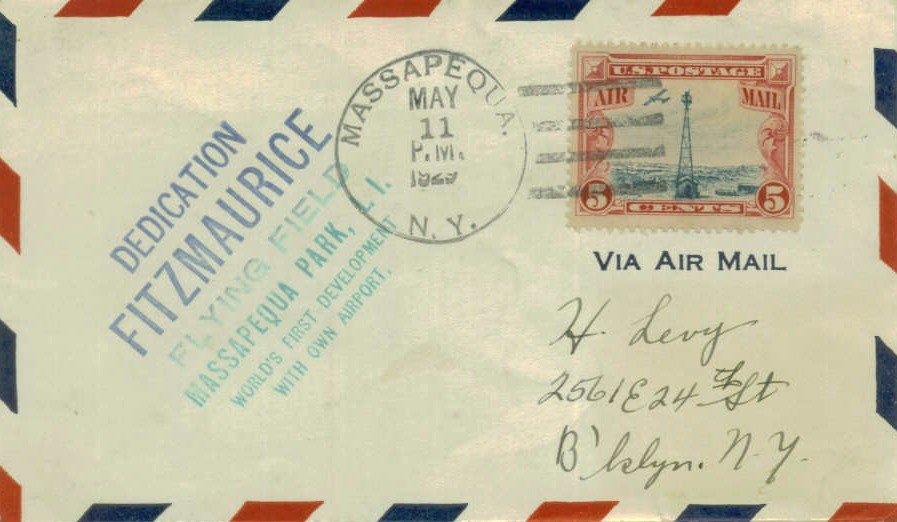
A postmark commemorated the 5/11/29 Dedication of Fitzmaurice Flying Field.
A postmark commemorated the 5/11/29 Dedication of Fitzmaurice Flying Field, described as "The world's first development with its own airport."

A photo from of the 5/12/29 dedication of Fitzmaurice Field.
According to the Massapequa Park website, Fitzmaurice Flying Field was dedicated on 5/12/29.
The field was named after the world-famous Colonel James Fitzmaurice,
copilot of the "Bremen," the first transatlantic flight from east to west.
A crowd estimated at 100,000 people visited Massapequa Park that day.

An article from the Daily News, covering the 5/12/29 dedication of Fitzmaurice Flying Field.

Fitzmaurice Field, as depicted on the 1930 "Rand McNally Standard Map of New Jersey With Air Trails" (courtesy of Chris Kennedy).

A circa 1930s photo (courtesy of Chester Hartwell) of a sign promoting a “hangar site purchased by the Airoscript Corp.
for the immediate erection of a 10 plane hangar, Fitzmaurice Field, Advance Aircraft Corp.”.
Fitzmaurice Field was not yet depicted on the November 1931 NYC-Albany Air Navigation Map.

The earliest aeronautical chart depiction which has been located of Fitzmaurice Field was on the August 1932 NY Sectional Chart.
It depicted Fitzmaurice as a commercial/municipal airport.

A circa 1930s aerial photo looking northeast at Fitzmaurice Field (the open rectangular area).
Note the grid of newly-constructed streets which had already begun to surround the field,
but the blocks within the streets were still filled by pine trees, not houses.

A circa 1930s photo of several monoplanes & biplanes in front of the hangar marked “Fitzmaurice Field” (courtesy of Sam Berliner).
The 1938 Aviation Facilities in NY State (courtesy of Bob Parmerter) described Fitzmaurice Flying Field as a 30 acre field having a 1,500' grass runway & one 100' x 80' hangar.

A 10/2/42 aerial view looking west at Fitzmaurice Field (from the National Archives, courtesy of Brian Rehwinkel)
depicted Fitzmaurice as a rectangular grass field with an airport circle marking in the center & a hangar at the north end.
Note the grid of streets adjacent to the west side of the field, but the blocks within the streets were still filled by trees, not houses.
The April 1944 US Army/Navy Directory of Airfields (courtesy of Ken Mercer)
described Fitzmaurice Field as having an 1,800' unpaved runway,
Fitzmaurice Field was no longer listed among active airfields in the 1945 AAF Airfield Directory (courtesy of Scott Murdock),
but it may simply have been overlooked as a relatively minor airfield.
Chris Bobka recalled, “My old instructor, Tom Murphy, I think was the manager of Fitzmaurice Airport after the war.”

A circa 1946-51 photo of the "Gyroport" facilities of the Gyrodyne Company at Fitzmaurice Field.

Fitzmaurice Field was depicted as a commercial/municipal airport
on the August 1946 NY Terminal Aeronautical Chart (courtesy of Tim Zukas).
Perhaps the most interesting chapter in the life of this little-known airfield came in 1946,
when helicopter pioneer Peter Papadakos bought the assets of the bankrupt Bendix Helicopter company & founded the Gyrodyne Company of America.
A small hangar facility was leased by Gyrodyne at Fitzmaurice Field,
and it was there that the Gyrodyne Model 2B compound helicopter was developed
and eventually performed demonstrated flights for seven Air Force pilots.

The 1947 USGS topo map depicted Fitzmaurice Field, along with a dizzying array of other general aviation airports,
almost all of which are long-gone.

A 1947 USGS topo map depicted Fitzmaurice Field as a rectangular property, with a single hangar along the north side.

A 1948 photo (courtesy of Sam Berliner) of Paul Kotze & his WW1 Thomas Morse S4C Scout in front of the Fitzmaurice Field hangar.
This particular Scout had been continuously based on Long Island since it was purchased as surplus at Mitchel Field in 1923.
From the 1920s through the 1950s, Paul Kotze of Merrick barnstormed the metropolitan area performing at many air shows.
Equipped with its original Marlin machine gun, it was one of the best preserved World War One fighters in the country.

A photo of damage caused to planes at Fitzmaurice Field from an 11/25/50 storm (courtesy of Charles Feldman).
By 1951 the growing Gyrodyne Company purchased land for a dedicated airfield & production complex in nearby St. James,
and relocated from Fitzmaurice Field to what became known as the "Flowerfield" site.

The last aeronautical chart depiction which has been located of Fitzmaurice Field was on the July 1952 NY Sectional Chart.
It depicted Fitzmaurice Field as having a mere 1,700' unpaved runway.

The last photos which have been located of Fitzmaurice Field were a pair of circa 1953 photos by Walter Winicki (courtesy of Robert Mott of the Bayport Aerodrome Society).
According to Robert Mott, the picture is “from around 1953 just prior to the field closing.
[The picture] is of a rare WW1 Thomas Morse Scout that belonged to local pilot Paul Kotze who hangared it at Fitzmaurice.
The 2 men are Tom Murphy the field manager & his father. That plane now hangs in the Cradle of Aviation Museum at Mitchell Field.”

A circa 1953 photo of Fitzmaurice Field by Walter Winicki (courtesy of Robert Mott of the Bayport Aerodrome Society).
According to Robert Mott, the picture “is of a Warner engine Great Lakes biplane. Tied down in the background is Walter Winicki’s Fleet 2.”
Fitzmaurice Field reportedly closed in 1953. Ironically, the airport was apparently a victim of the development that it was intended to attract.
Fitzmaurice Field was no longer depicted on the January 1953 NY Sectional Chart.

The last photo which has been located which shows any trace of Fitzmaurice Field was a 1953 aerial view.
The 2 unpaved runways were still recognizable, and hangars still remained standing on the west side of the field.
But construction had already begun on a school which would cover the southern portion of the former airport.
The site of Fitzmaurice Field eventually became the location of the McKenna & Hawthorn public schools,
and it was labeled as Hathorn School on the 1954 USGS topo map.
A 1980 aerial view showed that the 2 schools had completely covered the site of Fitzmaurice Field,
with not a trace remaining of the little airport.

A 1995-2014 photo of a historical plaque placed in 1995 at the site of Fitzmaurice Field.

As seen in a 5/4/09 aerial photo, the site of Fitzmaurice Field was covered by 2 schools & dense housing, with no remaining trace of the airfield.
The site of Fitzmaurice Field is located at the intersection of Roosevelt Avenue & Smith Street.
The names of several nearby streets bear homage to the former airfield, including Fitzmaurice Street & Lindbergh Street.
____________________________________________________
Long Island Aviation Country Club, Hicksville, NY
40.738, -73.52 (East of New York, NY)

A 6/29/29 photo of a TAT Ford Trimotor visiting Long Island Aviation Country Club on its Opening Day (courtesy of Mark Hess).
According to an article by John Fleischman in the 2/99 issue of Air & Space / Smithsonian Magazine,
this airfield was founded by an elite group of fliers who formed what they thought would be
the first of a string of aviation country clubs that would extend from coast to coast.
A national committee had been formed in April 1928 to issue charters,
and at one point, 114 such clubs were supposedly in the works.
The Long Island Aviation Country Club was co-founded by Darwin Adams, according to his obituary (according to Raya Koren).
Charles Lindbergh was a charter member of the Aviation Country Club in 1929.
He was brought in by its first president, Charles Lanier Lawrance,
who'd designed the Wright J5C Whirlwind air-cooled radial engine for the Spirit of St. Louis.
Lindbergh, who had just married Anne Morrow that May, taught his bride to fly at the club.
The club's treasurer was another giant of the aeronautics industry, Chance Vought,
and the board was fleshed out with society types, such as Cornelius Vanderbilt Whitney
and Reginald Langhorne "Peter" Brooks, a band leader & a superb young pilot (he was also the nephew of Lady Astor).
According to Mark Hess, “Hicksville Aviation Country Club opened on 6/29/29.
It was also known as the Long Island Aviation Club.
It was funded by F. Trubee Davison, Assistant Secretary of War for Aeronautics.”
The earliest photo which has been located of Long Island Aviation Country Club
was a 6/29/29 photo of a TAT Ford Trimotor visiting on its Opening Day (courtesy of Mark Hess).
An article entitled “Aviation Country Club on Long Island is Dedicated” appeared in the 7/6/29 issue of Air Transportation (courtesy of Noah Rechtin).
It said “Hicksville: A flying country club formed under the nation plan of the Aviation Country Clubs Inc. opened at this city on June 31
and will be known as the Long Island Aviation Country Club.”
The 1929 opening of the Aviation Country Club turned out to be very unfortunate timing, as the stock market crashed 4 months later.

Long Island Aviation Country Club Airfield, as depicted on the 1929 Washington-NYC Air Navigation Map #3.
The Sportsman Pilot wrote in 1929: "The Long Island club is no longer a test tube. It may have been an experimental device at first.
Now it has been elevated from the laboratory. It has become a beacon for guidance of other club units...
The Hicksville club has not contented itself with fair-weather flying & tea at the clubhouse, skeptical suspicions to the contrary notwithstanding."

A 1920s aerial view looking southeast at the hangar & clubhouse of the Long Island Aviation Country Club.
It may have still be under construction in this photo, as the hangar did not yet have its eventual double-arch roof.

A set of undated photos from a 1929 magazine article showing the Long Island Aviation Country Club clubhouse, hangar, and several planes (courtesy of Mark Hess).
According to an article in the 2/14/30 Long-Islander newspaper (courtesy of Mark Hess),
“The club obtained the use of approximately 200 acres of land for a flying field.
The field lies between Woodbury Road & the L.I. Railroad, adjacent to the farm of Mr. Blyman.
Louis Mussel, who will soon have his pilots license, is very kindly going to give free flight instruction to all club members.
Joseph Byrne, an engineer, is the clubs chief technical instructor.”

The earliest map depiction of the Aviation Country Club which has been located
was on the 1930 "Rand McNally Standard Map of New Jersey With Air Trails" (courtesy of Chris Kennedy).
For all the snobbish overtones, the Long Island club was set up for serious flying. A huge hangar was built, 200' wide by 60' deep.
Until the Second World War, 2 mechanics were on duty every day with 4 helpers to gas up the airplanes with high-octane fuel,
push them onto the line, and hand-prop the engines.

An undated street map depicted the Long Island Aviation Country Club as a mostly rectangular property with a small angular extension on the northwest corner.

The earliest Sectional Chart depiction which has been located of the Long Island Aviation Country Club was on the August 1932 NY Sectional Chart.

An undated aerial photo depicted the Long Island Aviation Country Club as a rectangular grass airfield with a few small buildings along the south side.

The 1934 U.S. Navy Aviation Chart (courtesy of Chris Kennedy)
depicted the Long Island Aviation Country Club as consisting of a rectangular-shaped field.
The Airport Directory Company's 1937 Airports Directory (courtesy of Bob Rambo)
described the "Long Island Aviation Country Club" as having a sod rectangular landing area, measuring 2,200' x 1,500'.

The earliest photo which has been located of the Long Island Aviation Country Club was a 1937 aerial view,
showing a large number of single-engine monoplanes & biplanes in front of a substantial hangar alongside a grass airfield.
Alan Reddig recalled, “My father, James Reddig, who was Grover Loening's Assistant Chief Engineer,
was an early member, and he had many fond memories of the Club.
I have Charles Lindbergh's autograph in the form of his pledge card
for one of the club's annual Christmas gift fund collections for the club's staff.
My father said that one of the last times he saw Lindbergh at the club
was when, a few day's after the Lindbergh baby had been kidnapped,
Lindbergh landed at the club to refuel before flying on with some police on board
to follow up on a tip that the baby might be somewhere in New England.
Dad said that everyone kept a respectful distance as Lindbergh went about checking out the plane
for the hop over Long Island Sound while the ground crew was fueling it.”

A 1930s aerial view looking north at the double-arch roof hangar of the Long Island Aviation Country Club, with 1 single-engine biplane visible at right.

A 1930s photo of the Goodyear blimp “Mayflower” at the Long Island Aviation Country Club.

A 1930s photo of de Havilland DH-60X Moth cn 547 NC5359 on amphibious floats in front of the Long Island Aviation Country Club hangar.

A 1/15/37 magazine ad for Hicksville's Gillies Aviation Corporation (courtesy of Alan Reddig),
noting their sales of Grumman, Waco, Fairchild, Stinson and Beechcraft airplanes, and the Fleetwings “Sea Bird”.
Alan noted, “My father [James Reddig] designed the Fleetwings Sea Bird.”

A 1937 photo by Alfred Eisenstaedt of the stainless steel Fleetwings Sea Bird F-4 NX16793 C/n F-401 at Hicksville Aviation Country Club.

A 1937 photo by Alfred Eisenstaedt of brand-new Fairchild 24H NC16871 C/n 3200 in front of the Hicksville Aviation Country Club hangars.
The Fairchild had been built that same year in nearby Farmingdale.

A 1937 photo by Alfred Eisenstaedt of Lockheed Electra 10A NC20Y C/n 1076 in front of the Hicksville Aviation Country Club hangars.

A 1937 or later aerial view (courtesy of Alan Reddig) looking northwest at the Long Island Aviation Country Club, showing 6 aircraft.
Alan Reddig observed, “The Vanderbilt Motor Parkway crossed the image from left to right.
The Parkway refused to allow the Club to build direct access to it from the Parkway, so the Club had to build a private access road from Jerusalem Avenue (to the east), which ran behind the Club’s hangars & parallel to the Parkway.
Nonetheless, when nonmembers flocked to view the Club’s flying activities, they would pull off the Parkway just over the fence from the clubhouse.
The ersatz 'parking lot' & the ruts leading to it from the Parkway are clearly visible in the photo.
The image was published in an issue of 'The Sportsman Pilot'; published after 1937 because a story on the back of the page references Bessie Owens’s flights in Europe/Asia/Africa in 1936-37.”
The 1938 Aviation Facilities in NY State (courtesy of Bob Parmerter) described the Aviation Country Club of Long Island Airport as a 2,200' x 1,400' rectangular sod field with 1 hangar.

A circa 1939 aerial view (courtesy of Bob Levittan) of Long Island Aviation Country Club.
The original caption read, "The latest types of private planes assembled on the flying field of the Aviation Country Club at Hicksville, L.I.
on June 30 for the club's 4th annual private Demonstration Air Meet.
An article (courtesy of Bob Levittan) described the club as follows:
"The Aviation Country Club, which is at Hicksville, is the swankiest of its kind in the country.
There are dozens of other flying clubs in the U. S., the most active ones lying west of the Alleghenies.
But most of them use commercial hangars & airports.
Often enough they consist of a group of enthusiasts who own a secondhand Waco & take off from a cow pasture.
The Aviation Country Club, however, counts 175 wealthy flying members.
Of these, 76 own their own planes & most of the rest are licensed pilots.
The Club's swimming pool, tennis courts & clubhouse (with 4 bedrooms) are frills.
The members really pay their $250 initiation fee & the $150/year dues
because the Club offers useful facilities for their planes:
a landing field, a big hangar, mechanics, fuel & oil.
It has a flying instructor, just as another country club would have a golf pro. It rents & sells planes.
Every now & then, it stages an air demonstration, comparable to an invitation golf match,
to which plane makers send their products & pilots."

A circa 1939 aerial view (courtesy of Bob Levittan) of Long Island Aviation Country Club.
The original caption read, "Aviation Country Club at Hicksville, L.I.
is the only one which boasts clubhouse, tennis court, swimming pool as well as hangar."

A circa 1939 photo (courtesy of Bob Levittan)
of several planes at the Aviation Country Club, including Stinson, Waco, and Fairchild.

A circa 1939 photo (courtesy of Bob Levittan) of Long Island Aviation Country Club.
The original caption read, "Members & guests of Aviation Country Club watch a Luscombe monoplane fly at air demonstration.
In formation is a Lockheed."

A circa 1939 photo (courtesy of Bob Levittan) of Long Island Aviation Country Club.
The original caption read, "The hangar at the club is a major reason for becoming a member.
Here 20 fair-sized planes can be stored at once.
Mechanics offer complete repair service, keeping an active watch on all members' planes,
giving them a thorough overhauling every 25 flying hours."
In nearly 20 years of flight operations, the Long Island Aviation Country Club never had a serious accident resulting in injury - not even at the annual airshow.
Instead of death-defying stunts & hell-for-leather pylon races,
manufacturers used the show to put on dignified exhibitions of their latest products.
The Flying Committee's 1939 invitation to manufacturers made the tone of the event clear.
"Each demonstrator will be asked to demonstrate his ship in the air for approximately 5 or 6 minutes.
The Committee will permit no stunting, excessive pull-offs & climbs or unorthodox maneuvering,
the demonstration being purely to show off the ship's best qualities.
It is important that each demonstrator realize that he is not in competition & also that no sales approaches be made."
The chance to present the best aircraft to the best people was irresistible to those in the business (many of whom belonged to the club anyway),
and the shows were hugely successful - too successful in some ways.
Club members & demonstrators were issued entry ribbons, but keeping the ordinary people of Hicksville away was difficult.
They lined the roads & trespassed on the airfield for a glimpse of the amazing craft on display or flying by.
In 1939, the club had TWA's "stratosphere laboratory plane" & a trio of Goodyear blimps,
as well as flybys from Pan Am's Sikorsky S-42 Bermuda Clipper flying boat & the Douglas DC-4 prototype.
The crowds, both beribboned & uninvited, were enthralled.
From the beginning the club was a perfect place to fly, recalled former member Betty Gillies.
It had 100 acres, most of it an "all directions" grass landing field in the midst of an endless plain of potatoes.
In case of a forced landing, the potato fields were a great reassurance, said Gillies.
Betty's first ship was a de Havilland 60 X Moth.
She bought it from Grover Loening, who had the airplane shipped from Britain.
His aeronautical engineering firm put it on floats, and Bud Gillies, Betty's husband, was Loening's test pilot.
When Loening was done, Loening sold the Moth to Betty. She put it back on wheels.
"We were in the business," Gillies explained matter-of-factly, "so we had the airplanes."
The club's mix of status, wealth, and insider connections produced some unusual scenes on the flightline.
The club newsletter noted in August 1938 that "Mr. Roy Grumman is now keeping his new G-32A in the hangar.
It is a 2-place conversion of the Navy F-3-F fighter with an 830 HP Cyclone.
It can climb to 12,500 feet in 5 minutes."
Imagine a modern day "Mr. Grumman" rolling up at a general aviation field in a civilian version of his company's Navy F-14 Tomcat.
The same issue noted that Mr. Howard Hughes had dropped by the club at the conclusion of his record 3 & a half day around-the-world flight
and had been ferried back to Newark Airport in the club's Stinson.

A 6/30/40 photo by James Reddig (courtesy of Alan Reddig) of a rare TWA Douglas Sleeper Transport (predecessor of the DC-3) at the Long Island Aviation Country Club.
According to Alan Reddig, “This was one of the 'Family Day' events at the Aviation Country Club in Hicksville.
TWA gave members & their families short hops around the area in this DC-3.
It was on this occasion, in this aircraft, that my sister had her 1st airplane ride.
We also have some 16mm home movies of the event, and it’s clear from her reaction
that she was just as excited about the piece of chewing gum the TWA attendants gave each child as they deplaned as she was about the ride itself.”

A 6/30/40 photo by James Reddig (courtesy of Alan Reddig) of a Piper Cub on straight floats in front of the Long Island Aviation Country Club hangars.
Jim Grant observed in 208, “This J3 is a rare J3P model that Piper built with a Lenape Papoose radial engine.
They built just 27 of them & 3 still exist on the FAA registry, including this one, N20280, now registered to an Ingrid Zimmer-Galler of Jefferson MD.”

A 6/30/40 photo by James Reddig (courtesy of Alan Reddig) of a Grumman flying boat & several other general aviation aircraft at the Long Island Aviation Country Club.
Alan Reddig reported, “It was taken during one of the Club’s events variously known as 'Industry Day' or 'Family Day.'
Dad, who was a member of the Club, designed the all-stainless-steel Fleetwings Sea Bird, which can be seen in the background at the left of the photo.”

A circa 1940s response card for the Long Island Aviation Country Club’s annual appeal for its Christmas Bonus fund to be distributed to “Club & Hangar Employees & Staff”,
notably with Charles Lindbergh’s autograph (courtesy of Alan Reddig).
Alan Reddig observed, “Although it’s post-card-size (5-3/4x3-3/8 inches), and addressed to 'Col. Chas. A. Lindbergh, Lloyd Neck, Huntington, N.Y.' on the reverse,
it clearly did not go through the mail; there was no postage stamp or postmark applied.
He probably picked it up at the Club, filled it out, and handed it back in.
At some point, it was folded vertically down the middle, but is in otherwise excellent condition.”
WW2 seemed to help the club in the first months; flying lessons were in high demand.
Barbara Kibbee Jayne was hired by Bud Gillies early in 1942 as the club's chief instructor.
He'd flown up to Troy, New York, where Jayne had just qualified
as the first woman instructor in the new Civilian Pilot Training Program, just to talk her into it.
After she reported for work in Hicksville, there weren't enough hours in the day. She taught 7 days a week, dawn to dusk.
"All kinds of people went out & learned to fly.
To this day, I can't think of anything more thrilling than a first solo. It was just you & God."
Despite the workload, teaching flying at the club was fun for Jayne in ways that it never was after the war.
In 1942 aviation fuel was not yet being rationed,
and members could still fly up to Nova Scotia to pick up salmon or down to the Chesapeake Bay to hunt ducks.
Some club members joined the Civil Air Patrol & were sent out to monitor the coast,
where they "spotted quite a few submarines off the island," Jayne recalls.
Over time, the fabric-covered biplanes were joined by high-wing monoplanes such as the Fairchild Ranger,
and then the first all-metal sport aircraft, such as the Ryan S-T.
These & other models are the signature airplanes of what historians now call the Golden Age of Aviation.
Other aircraft based at or visiting the club included the Beech 17,
Bellanca Skyrocket, Lockheed 10, Boeing 247-D, and Grumman G-21.

An undated magazine ad for Hicksville's Gillies Aviation Corporation (courtesy of Alan Reddig).

A 10/1/42 aerial view looking north at the Aviation Country Club Airport from the 1945 AAF Airfield Directory (courtesy of Scott Murdock)
depicted the field as an open grass area.
As the war continued, the club found it harder & harder to retain good help.
Jayne says Grumman would lend mechanics to the club for a day or an afternoon.
By then, the club's wartime flying days were numbered.
Jayne herself was spending more & more time test flying production aircraft at Grumman.
Many of the club's women members had gone into the service as ferry pilots.
Jayne is not sure exactly when the club suspended operations for the duration of the war,
but almost her last memory of the club was of a party there -
not a high-society event but a wedding thrown by the Polish refugee couple who served as the live-in housekeeper & cook.
The April 1944 US Army/Navy Directory of Airfields (courtesy of Ken Mercer)
described the Aviation Country Club as having a 2,400' unpaved runway.
The 1945 AAF Airfield Directory (courtesy of Scott Murdock) described the Aviation Country Club Airport
as an 80 acre irregularly-shaped property within which were 2 sand & sod runways, with the longest being the 2,400' east/west strip.
The field was said to have a single 200' x 60' brick & wood hangar, and to be privately owned & operated.

A June 1946 photo (courtesy of Gerry Masher) of a Vultee BT-13B/SNV-2 NX60496 & the sole example built of the 1934 Waco S3HD
at what was described only as “a country club on Long Island” (presumably Hicksville).
This is the last photo which has been located of the Hicksville airfield.
John Ricciotti reported in 2013, “The 1934 Waco S3HD was ordered & bought by Miles Vernon whose address at the time was 1 Wall St, NY, NY.
I purchased it last month. It was last rebuilt in 1964 and is in immaculate condition today.
The S3HD was the only civilian version built of Waco's military fighter bomber.
The S3HD has a Pratt & Whitney R985 Wasp Junior engine. It is quite a performer.”

The front & back of an undated matchbook (courtesy of Richard Sloan) with the logo of “The Aviation Country Club” - was this the Long Island Aviation Country Club?

The August 1946 NY Terminal Aeronautical Chart (courtesy of Tim Zukas)
depicted the Hicksville "Aviation Country Club" as a commercial airfield.
The 1947 USGS topo map depicted Long Island “Aviation Country Club” Airfield, along with a dizzying array of other airfields,
almost all of which are long-gone.

The 1:24,000 1947 USGS topo map depicted Long Island “Aviation Country Club Airport” as an open area with 2 small buildings along the south side.
Former airfield worker Alfred Merrill did not get back to Long Island to visit his parents until the spring of 1948,
only to be told the club had just closed permanently.
Standing outside his parents' house in Hicksville, he found the silence strange.
There were no small aircraft taking off from the club airfield.
On another visit, Merrill drove over to see for himself.
"The place had been bulldozed & they were building Levittown," he recalls.
"The buildings were gone. What happened to all our planes I can't say, but everything was gone."
For some, that's the final irony of the Aviation Country Club of Long Island: It's buried under Levittown.
What was once an elite social club in pre-war America was sold off for post-war America's most famous mass-housing development.
For former members like Betty Gillies, the memory of the club's end was painful.
"That horrible time," she said. "Those little houses. Hundreds of them."
The club had fallen victim to rising land values.
While Hicksville was charmingly rural in 1929, by the late 1940s it was about to become solidly suburban.
And as the houses closed in, it became dangerous to operate an airfield.
When William Levitt offered $2,200 an acre, the club ceased flying in May 1948 & began looking for a new home.

The last aerial photo which has been located of the Long Island Aviation Country Club was a 9/1/48 USGS aerial view.
It depicted the buildings along the south side of the grass airfield.

A circa 1940s photo of the Long Island Aviation Club hangar looking west from the Motor Parkway.

The last depiction which has been located of the Country Club airfield was on the January 1950 NY Sectional Chart (courtesy of Mike Keefe).
It depicted the Hicksville "Country Club" airfield as having a 2,300' unpaved runway.
The club planning committee found a new site in 1950, a small private airport at Commack.
The members, however, had lost interest, and that August, 90% voted to dissolve the club forever.
The Long Island Aviation Country Club Airfield was no longer depicted on the July 1950 NY Sectional Chart.
A “FOR SALE” advertisement in the 2/25/50 Newsday (according to Richard Sloan) listed the Aviation Country Club of Long Island hangar & clubhouse for sale to the highest bidder.
The 3/23/50 Newsday (according to Richard Sloan) said the Aviation Country Club of Long Island had been sold to Levitt & Sons for $175,000, with the club to vacate by the end of April.
“Planes are still flying out of the field, and will until the 11th hour.”
The 4/5/50 Newsday (according to Richard Sloan) said the Levitt & Sons started staking out about 500 plots of the former Aviation Country Club of Long Island, each one measuring 60’ x 100.’
It was announced on the previous night that the clubhouse was sold to the family of Mrs. John Kraft,
who said it would be re-located & would probably be rebuilt into 2 or more homes. Bids were being received for the sale of the hangar.
The Aviation Country Club hangar was reportedly reassembled in Bethpage & used to manufacture pre-fabricated sections of the Levitt homes,
and then served for years as a perfume factory, then a pickle works, and finally a tuxedo warehouse.
Local historians say parts of other club buildings were trucked away & incorporated into 5 private homes.
A 1953 aerial photo showed the site of the Long Island Aviation Country Club Airfield to be occupied by dense housing,
with not a trace of the airfield still recognizable.

A circa 2012 photo of the former Aviation Country Club hangar as it was relocated to Revere Avenue & Lexington Avenue in Bethpage.

A 2012 aerial view looking north at the former Aviation Country Club hangar as it was relocated to Revere Avenue & Lexington Avenue in Bethpage.

A 2017 aerial photo shows no trace remaining of Long Island Aviation Country Club,
but the alignment of the adjacent Long Island Motor Parkway on the south side of the airfield site is still recognizable.
Today a street in Hicksville called Pilots Lane is essentially the only sign that the Aviation Country Club of Long Island ever existed.
____________________________________________________
Grumman Bethpage Airfield (BPA), Bethpage, NY
40.75, -73.495 (West of Republic Airport, Long Island, NY)

Grumman's Bethpage Airfield, as depicted on the November 1938 NY Sectional Chart.
This was the factory airfield of the Grumman Aircraft Corporation,
which relocated from Farmingdale after purchasing 120 acres of land in Bethpage in 1936.
Thousands of aircraft were eventually produced at the factory.
Grumman's Bethpage Airfield was not yet depicted on the April 1938 NY Sectional Chart.
The earliest aeronautical chart depiction which has been located of Grumman's Bethpage Airfield was on the November 1938 NY Sectional Chart.

A 1938 aerial view looking northwest at the Grumman Bethpage airfield showed it to be an irregularly-shaped grass field with a factory on the east side.

A circa 1938 aerial view looking east at Grumman's first Bethpage factory, Plant 1, on the east side of their airfield.


A 4/10/40 photo by Rudy Arnold of the sole prototype of Grumman's XF5F-1 Skyrocket C/n 1442 at the Bethpage plant, in its original configuration (short nose, no prop spinners).

A 1940 photo of the sole prototype of Grumman's XF5F-1 Skyrocket being run up at the Bethpage plant, after modification to nose & added spinners.

A 1940 photo of Grumman Widgeon amphibians under assembly in the Bethpage plant.


A 10/1/42 aerial view looking southeast at Grumman Airport from the 1945 AAF Airfield Directory (courtesy of Scott Murdock)
depicted the field as having 2 paved runways.
Grumman's Bethpage Plant 3 was built from scrap steel from the New York City El specifically for the production of the F6F Hellcat.
Mark Ball recalled working at "Bethpage as a production test pilot from November 1943 until September 1945."
He flew everything from F6F Hellcats, F7F Tigercats, F8F Bearcats, to Widgeon amphibians.
Mark recalled that the primary runway was repaved & lengthened by 1,000' in 1945,
a process which involved temporarily operating from shortened portions of the main runway,
and at one point led to operating solely from the much shorter crosswind runway.
While this was fine for the smaller F6F & amphibians,
it wasn't very comfortable for the twin-engine F7F Tigercat fighter,
with its much longer runway requirements.

F6F Hellcats are assembled on Grumman's Bethpage production floor in 1944.

An 11/12/44 photo of Grumman XF4F-8 Wildcat BuNo 12228 at Grumman Aircraft Engineering Corporation Bethpage.
The 1944 US Army/Navy Directory of Airfields (courtesy of Ken Mercer)
described Grumman Bethpage Field as having a 5,400' hard-surfaced runway,

A 1945 photo of rows of Grumman F6F Hellcats being readied for delivery from the Bethpage plant.

A 1945 photo of a Grumman F7F Tigercat at the Bethpage airfield.
The 1945 AAF Airfield Directory (courtesy of Scott Murdock) described Grumman Airport
as a 110 acre irregularly-shaped property within which were 2 blacktop runways runways, with the longest being the 5,400' northwest/southeast strip.
The field was said to have four 140' square brick hangars,
and to be privately owned & operated.
Grumman's Bethpage Plant 2 had a USAAF code of “GR” during WW2.

A 2/2/46 photo of the sole prototype of the Grumman G-72 Kitten II light general aviation plane at Bethpage.
The Kitten was an attempt by Grumman to enter the post-WW2 general aviation market,
but the development project was terminated in 1946, and the Kitten II was used as a company transport until it was retired in the mid-1960s.
Grumman's Bethpage airfield was depicted as a commercial/municipal airport
on the August 1946 NY Terminal Aeronautical Chart (courtesy of Tim Zukas).
Grumman's Bethpage Plant 3 produced a staggering total of 12,275 F6Fs during WW2.
Through the end of 1946, Grumman Bethpage produced a total of 1,768 F4Fs, 364 F7Fs, 144 J2F-5s,
2,293 TBFs, and an unspecified number of F8Fs, G-21As, and G-44s.

A January-June 1946 photo of Grumman G-44A Widgeon amphibian NC86617 C/n 1443 at the Bethpage plant.
The 1947 USGS topo map depicted “Grumman Airport”, along with a dizzying array of other airfields, almost all of which are since long-gone.

A circa 1940s aerial view looking northwest at the Grumman Bethpage airfield.

A 1952 profile of the XF10-1 Jaguar prototype at Bethpage (courtesy of Brett).

A 1952 front view of the XF10-1 Jaguar prototype at Bethpage in 1952 (courtesy of Brett).

A 1953 aerial view depicted Bethpage as having 2 paved runways still in use, with dozens of aircraft on the west & east sides of the field.

A closeup from the 1953 aerial view showing large numbers of newly-built Grumman aircraft on Bethpage's northeast ramp.

The 1953 USGS topo map depicted “Grumman Airfield” as having 4 paved runways & multiple taxiways & ramps.

A circa 1960 photo of a Grumman HU-16 Albatross amphibian parked in front of the Bethpage control tower.

A 1956 photo of S2F-1 Trackers on the Bethpage production line.

In a 1960 aerial view looking northeast at the Bethpage airfield, two runways appeared to still be in use, with a 3rd former runway used for aircraft parking.
In 1962 Grumman won the contract to design & build the Apollo Lunar Module (better known as the LM).
Grumman designed, assembled, integrated & tested the LM at its Bethpage facility.

A 10/5/64 photo at Grumman Bethpage of Astronaut James Lovell, shrouded in a thermal suit over his regular pressure suit, with operable back pack,
as he prepared to check the LEM cockpit for accessibility during the NASA Inspection & Review of the all-metal mockup of the Lunar Excursion Module.
He was also hooked to the “Peter Pan” hoist rig that simulated the 1/6th gravity condition on the moon.
Through 1972 Grumman Bethpage built a total of 25 LMs.
According to Bert Nelson, “The awesome Boeing 'Pregnant Guppy' [was] used to ferry the LEM to Florida.”
Grumman Bethpage Field was described by the 1962 AOPA Airport Directory as having 2 paved runways.
Frank Dioguardi recalled, “I started on the line in Calverton 1962 & worked my way up, with Corky Meyer’s help.
I flew for Grumman 1966-73. I was Flt 73 (Grumman Pilot Number).
Corky Meyer was Grumman Flt 25, Earnest Rorer Flt 65, Dick Bauer Flt 66.”

A 1965 Grumman map of their Bethpage airfield & adjacent facilities.

A 3/29/66 USGS aerial view depicted Bethpage as having 2 paved runways still in use, and a total of 18 aircraft visible on the field.

A 3/14/74 USGS aerial view depicted the Bethpage airfield, with the employee parking lots filled with thousands of cars,
but ironically only a single aircraft was visible parked outside on the field.

An undated view of NASA's Shuttle Training Aircraft (a modified Grumman Gulfstream II) at Bethpage (courtesy of Brett).
Don Vining recalled, “I worked for Grumman Data Systems in Plant 40 (now Briarcliffe College) through most of the 1970s
and enjoyed watching the F-14 perform in several company airshows in Calverton,
but the best show I ever saw was when I watched an F-14 takeoff from the Bethpage air strip around 1976-77.
At that time Grumman was upgrading the electronics in the F-14 in Bethpage & would quietly fly in about 1 jet per month.
A friend of mine who was a flight test engineer in Calverton called one day & told me an F-14 was scheduled to takeoff in a half hour.
So we drove out to the airstrip & literally stood right on the edge as the plane taxied out. The test pilot waved as he went by.
He turned around at the end of the airstrip (right up against South Oyster Bay Road),
lit his afterburners, and did a full-performance takeoff right in front of us!
By the time he reached the halfway point where I think a small tower was located,
he looked like he was going straight up & I could see his wings folding back as he disappeared into the clouds.
The noise was incredible & the air was crackling like when a Saturn V was being launched.
Apparently those test pilots could get away with anything!”

The Grumman Bethpage airfield was still depicted as an active airfield on the 1979 NY TCA chart (courtesy of Bill Suffa).
It was depicted as having 2 paved runways, with the longest being the 6,600' northwest/southeast runway.

The 1979 USGS topo map depicted a total of 3 runways at the Grumman Bethpage Airfield.
A 1980 aerial view depicted a single E-2 & another twin-turboprop on the east side of the Grumman Bethphage airfield, as well as 5 light aircraft (flying club aircraft?).

A 1981 photo of a Space Shuttle wing being removed from a vertical jig assembly inside the Grumman Bethpage factory.
The June 1982 NY Terminal Aeronautical Chart (courtesy of Mitchell Hymowitz)
depicted Grumman Bethpage as having 2 paved runways, with the longest being the 6,600' northwest/southeast runway.
By the time of the 1982 AOPA Airport Directory (courtesy of Ed Drury),
Grumman Bethpage Field was reduced to a single active runway (6,000' concrete Runway 15/33).

An early 1980s photo of a Grumman X-29 experimental forward-swept-wing aircraft being towed at night at the Bethpage factory.
The Bethpage airfield was surrounded by extremely dense development,
leaving insufficient room to operate modern high performance jet aircraft.
For this reason, production & flight test of Grumman's last jet aircraft designs (A-6 & F-14)
were conducted at the newly-constructed Calverton Naval Weapons Plant Airfield further east on Long Island.

The last aeronautical chart depiction which has been located showing the Grumman Bethpage airfield still in operation
was on a 1987 NY Terminal Aeronautical Chart (courtesy of Gwen Shafer).
It depicted Bethpage as having a single 6,600' paved northwest/southeast runway, and a Non-Federal Control Tower.
Anthony Darienzo recalled, “I am retired Air Traffic Controller. I worked for the FAA for 25 years at several facilities on Long Island.
During the mid-1980s, I was the Chief Controller at Republic Airport in Farmingdale.
Non-federally operated control towers must be inspected by the nearest FAA Tower Chief on an annual basis.
The purpose of this inspection is to review the equipment, personnel, facility publications, etc., to determine whether the non-federal control can continue to operate.
On 3/17/87, I inspected the Grumman Bethpage Tower & determined that the facility was operated in accordance with federal mandates
and could continue operations for another year.
I remained at Republic for several more years & never conducted another inspection at Grumman Bethpage.
Irrespective of depiction on any chart, the facility could not have legally operated after March of 1988.
This prohibition would apply to any type of operations, public or private.”
George Morrish recalled, “In 1988/89 I was the commanding officer of The NCPD Air Bureau, based at Grumman, Bethpage.
We had 4 helicopters. They had Bell Jet Ranger & Long Ranger helicopters. We also had a old Bell 47 which couldn't fly.
We flew 2 to 3 one-hour patrol flights daily divided over two 8t hour tours, and responded as necessary for various assignments, mostly medevac.
I also had some pictures of a Super Guppy (a huge blimp-like 4-engine prop driven cargo plane that they used to transport large items from Bethpage) taking off.
As far as I know, it was the last time for that plane at Bethpage. I remember both sides of the Grumman runway lined with people witnessing the event.
It was a foggy day, which didn't make for great shots, but the pictures show corkscrew mist coming off each engine.
I spent 15 great months there with some great Grumman people.”

A 9/27/90 photo by George Morrish at a gathering commemorating the last fixed-wing flight from Bethpage Airfield, an S-2T Turbo Tracker.
George recalled, “I was invited back to witness the last fixed-wing takeoff from that facility.
It was a S-2T Turbo Tracker which was there for an update for the Chinese Nationalist Government.”

A 9/27/90 photo by George Morrish of the last fixed-wing aircraft to fly from Bethpage Airfield, an S-2T Turbo Tracker, with the control tower visible in the background.

A 9/27/90 aerial view by George Morrish looking north at the takeoff of the last fixed-wing aircraft to fly from Bethpage Airfield, an S-2T Turbo Tracker, with hangars visible in the background.
George recalled, “I believe they're the only photos taken that day... at least the ones from above.”

A 9/27/90 aerial view by George Morrish looking east at the last fixed-wing aircraft to fly from Bethpage Airfield, an S-2T Turbo Tracker taxiing southeast on Runway 15.
The sole remaining Grumman aircraft production line (the E-2 Hawkeye) was relocated in the 1990s to St. Augustine, FL.
The Grumman Bethpage airfield was depicted on the December 1993 NY Sectional Chart as an abandoned airfield.

A 1994 USGS aerial view looking northeast showed closed-runway X markings on Bethpage's primary runway. Portions of at 2 other runways still existed.

A 1997 aerial view by Tom Kramer looking southeast at the closed Grumman Bethpage airfield.

A 1999 aerial view looking east at the remains of the Grumman Bethpage Airfield by Philip Kineyko.

A circa 2001-2005 aerial photo looking south at what appear to be former hangars at the Bethpage complex,
with some of the remainder of the runway pavement along the bottom-left.
Carlton Klein reported, “The old Grumman plant still has one significant aviation usage (at least it did in 2001 when I was last there):
it is used as a base for one of Nassau County Police Department's Bell 206L LongRanger helicopters.
I used to live on Eastern Long Island & took the Long Island Railroad into NYC for work everyday;
we would go right by Bethpage & often I would see the helicopter being wheeled out of the hangar on a dolly.
They also had some sort of motorpool there
as there were always several patrol cars in various states of disrepair in a parking lot nearby.”
Tom Kramer reported from an overflight in 2003 that "about a quarter of the runway remains & parts of the main ramp.
Since construction is already completed of the office park (except for a field adjacent to the runway on the eastern side),
I don't think the remaining runway will be torn up completely anytime soon.
They built a road along & over it's western edge & a new water tower is about 100' from it's eastern edge.
Two closed X's are clearly visible."
What a sad end for a historic airfield, where thousands of our country's military aircraft were built & took their first flights.

A 2005 aerial photo by Paul Freeman, taken from a Diamond Eclipse at 8,000 feet, looking northeast at the former Grumman Bethpage Airfield.
As of 2005, the Nassau County Police Heliport (8NY9) is listed as an active heliport on the northeast side of the former Bethpage airfield.
The heliport is listed as having 4 helicopters based at the facility.

A circa 2006-2009 photo (courtesy of Fred Miller) of the 2nd-to-last built F-14D Tomcat (“Felix 101”, BuNo 164603) displayed outside the Bethpage Grumman plant.
Fred reported that Felix 101 was shut down for the last time at nearby Republic Airport on 10/4/06 & trucked to Bethpage for display.

A pre-2007 photo of the remains of a former runway or taxiway at Bethpage.

Two pre-2007 photos of the several former hangars at Bethpage.
Dave Accetta reported in 2007, “Rainbow Cablevision has taken over much of the existing buildings on the old Grumman Bethpage Airport.
They use the active heliport quite often for their Sikorsky S-76s, based out of Farmingdale.
Inside the buildings you will find a massive telecommunications facility that houses the broadcasting center for Rainbow.
Many of the areas are placarded as to what the building formerly housed.
I remember one in particular that mention that the room I was in was where the Grumman section of the Apollo lunar modules were built.”
Ken Thalheimer reported in 2009 that the completed display of the F-14 at Bethpage is “floodlit at night with changing colors.”
He also reported, “In the field by the water tower which is the old main runway a local Honda dealer has built their service department.
A large building with a huge storage lot for new inventory which backs up to the LIRR tracks. The facility was recently completed.”
As of 2009, a portion of the massive Grumman facility was being reused as Grumman Studios,
a “160,000 square foot facility with 7 huge stages, massive storage facilities, acres & acres of paved outdoor space.
The birthplace of the Apollo lunar landing module has given rise to NY’s largest production facility – Grumman Studios.”

A February 2009 photo of an HH-60 Blackhawk fuselage being lifted at Grumman Studios for the filming of the movie Salt.

A circa 2012 floorplan of the “Grumman Studios”, which occupy a portion of the former Grumman Bethpage facilities.

A pre-2013 photo of the Grumman Studios' “Stage 1” at Bethpage.
An article by Peter Garrison entitled “Aftermath: Vectors to ZMB” in the 10/6/17 Flying Magazine described how obsolete data about Bethpage Airfield contributed to a fatal accident:
“The C35 Bonanza, N5946C, was cruising at 6,500' when there was a sudden loud bang from the engine compartment, followed by a smell of oil. The IO-470 sputtered & lost power.
The engine failure took place a few seconds after the JFK Departure controller who had cleared 46C into the New York Class B handed the flight off to La Guardia Departure.
At that moment, the Bonanza’s heading was 282 degrees, and it was making a 142-knot groundspeed against a headwind of 20-25 knots.
The pilot, without declaring an emergency, said, “I’m gonna have to take it down at the closest spot.”
The controller immediately reeled off a list of possibilities: La Guardia, Kennedy, Westchester, Republic Airport.
“OK,” the pilot replied, “Farmingdale is the closest airport, 9 miles. OK, yeah, I’m not going to make Farmingdale.”
Then came a lifeline. “There is a strip about your 10 o’clock & 5 miles,” the controller said. “Bethpage Airport.”
The pilot grasped at it. “Give me this airport,” he said. “I’m not seeing it.”
“There’s a strip right about at your 12 o’clock & 3 miles... The strip is a closed airport, ah, I just know there is a runway there, about 11 o’clock & about a mile and a half now.”
The Bonanza was at 1,400 feet msl. The pilot searched for the runway, but saw only buildings.
“There’s a strip about 1 o’clock & less than a mile,” the controller repeated. “It’s a closed airport; I have no information about it, unfortunately.”
The pilot never found the Bethpage runway. He tried to land on railroad tracks, but luck was not with him.
His right wing struck a barrier at the only grade crossing in the vicinity, and the airplane flipped over & burst into flames.
The pilot died from impact trauma and burns; the passenger survived with serious injuries.”
Garrison continued, “The reason the pilot failed to find the Bethpage Airport was that it had been replaced several years earlier by an industrial park.
The reason the controller vectored him to it was that the nonexistent Bethpage runway was still depicted on his radar screen.
It emerged from the National Transportation Safety Board’s investigation of this accident
that the FAA lacked a formal procedure for ensuring closed airports were purged from the radar video maps used by controllers.
The pilot might still have salvaged the situation by landing on any of several golf courses, or on the parkway that the controller pointed out to him,
if only he had not been led to believe - because of a grotesque & cruel bureaucratic oversight - that a runway lay just ahead.
Pilots reading this account will be relieved to know that the FAA now has a formal procedure for purging nonexistent airports from controllers’ databases.
You have to wonder, though: Why didn’t they think of that before?”

A 2018 aerial view looking northeast showed the former Grumman Bethpage factory building remains, but all traces of the airfield have been erased by redevelopment.
See also:
http://www.lihistory.com/specpio/runway1.htm
http://www.lihistory.com/9/hs9grum.htm
____________________________________________________
Hazelhurst Aviation Field #2 / Mitchel Field / Mitchel AFB, Garden City, NY
40.725, -73.595 (Southeast of La Guardia Airport)

A 1917 view looking south at a biplane flying from Hazelhurst Aviation Field #2.
During the American Revolutionary War this property was known as the Hempstead Plains & used as an Army enlistment center.
In the War of 1812 & in the Mexican War, it was a training center for infantry units.
During the American Civil War, it was the location of Camp Winfield Scott.
In 1898, in the Spanish–American War, it was known as Camp Black.
This field was established in 1917 as Aviation Field #2 just south of Hazelhurst Field
to serve as an additional training & storage base, part of the massive Air Service Aviation Concentration Center.
Curtiss JN-4 Jennies became a common sight over Long Island in 1917 & 1918.
Hundreds of aviators were trained for war at these training fields, two of the largest in the United States.
Numerous new wooden buildings and tents were erected on Field #2 in 1918 in order to meet this rapid expansion.

A USAAC photo of the “Signal Corps Flying School, Mineola”.

"Aviation Field #2" was depicted as an irregularly-shaped outline on the 1918 USGS topo map, along with nearby "Hazelhurst Aviation Field #1".
Hazelhurst Aviation Field #2 was renamed Mitchel Field in 1918,
after John Mitchel, the youngest elected Mayor of New York City,
who perished in a 1918 crash after joining the Signal Corps Army Air Service.


A circa 1920-23 photo of a rare LWF Model H Owl trimotor mail biplane at Mitchel Field, with its unusual twin-boom configuration.
Lewis Layne was killed in a crash of a Curtis Oriole at Mitchel Field on 6/27/1920 (according to Layne Bumgardner).
On 11/27/20 the Pulitzer Trophy Race was held at Mitchel Field - the race consisted of 4 laps of a 29 mile course.
Thirty-eight pilots entered & took off individually.
The winner was Capt. Corliss Moseley, flying a Verville-Packard VCP-R racer, a cleaned-up version of the Army's VCP-1 pursuit plane, at 157 mph.
In October 1923, Mitchel Field was the scene of the first airplane jumping contest in the nation.
During the same year, two world's airplane speed records were established there.

Mitchel Field, as depicted on the 1923 New York – Bellfonte Air Navigation Map #3 (courtesy of David Brooks),
along with the nearby Roosevelt Field & Hazelhurst Field.
In 1924, the airmail service had its inception in experimental flights begun at Mitchel Field.

A 1924 aerial view looking west at the row of WW1-era hangars at Mitchel Field.
Note the roof of each hangar was painted with 1 letter, together spelling out “Mitchel”.

A 10/12/27 photo of a “Line inspection” in front of a Mitchel Field 61st Service Squadron Engineering Department hangar of a Douglas C-1 biplane transport (courtesy of Ford Lauer).
Bernie Shearon noted, “The lower inscription is 'FAID', which would indicate the plane was assigned to the Fairfield Air Intermediate Depot at Wright Field.”

“Mitchel Field Aviation Grounds U.S Govt.”, as depicted on a 1927 Hyde road map (courtesy of Kevin Hale),
along with the nearby “Aviation Field Curtis Aeroplane & Motor Corp.” to the northwest.

The location & layout of Mitchel Field, as depicted on the 1928 Commerce Department Airway Bulletin (courtesy of David Brooks),

A remarkable 3/10/28 aerial view looking northwest at a snow-covered Mitchel Field (courtesy of Ford Lauer).

A 1929 photo of James Doolittle at Mitchel Field, on the occasion of him becoming the 1st pilot to use only instrument guidance to take off, fly a set course, and land (courtesy of Paul Siwulich).
A 1929 NY Legislative Report (courtesy of Tom Heitzman) described Mitchel Field as a 280 acre rectangular property
having a 4,000' x 3,000' sod landing field.

A 1929 photo of a Curtis Pulitzer Racer at Mitchel Field.
Mitchel Field continued to grow after WW1 & a major new construction program was undertaken from 1929-1932,
to turn the temporary wartime facilities into a permanent Army post,
including the construction of housing, warehouses, operations buildings, and 8 massive steel & concrete hangars.
In September 1929, Lt. James Doolittle made the world's first blind flight.
Mitchel Field, as depicted on the 1930 "Rand McNally Standard Map of NJ With Air Trails" (courtesy of Chris Kennedy),
along with the nearby Roosevelt Field & Hicksville Aviation Country Club Airfield.

A 4/3/30 photo of an inspection of Army biplanes at Mitchel Field. Bernie Shearon noted, “The first 7 from the left appear to be Curtiss Falcon observation planes.”

A 1931 aerial view looking west at Mitchel Field (courtesy of Brett) showed a large number of Army biplanes, and a long row of hangars along the north side of the field.
A plaque was erected in December 1931 “Commemorating the site of Aviation Field #2” by the Daughters of the Revolution.

The earliest Sectional Chart depiction which has been located of Mitchel Field was on the August 1932 NY Sectional Chart.

A circa 1930s aerial view looking southeast at Mitchel Field showed the large number of hangars & other buildings.
The airfield still consisted of an open grass area.

A circa 1931-36 photo of a Keystone B-6A biplane bomber of the 1st Bomb Squadron, 9th Bomb Group, at Mitchel Field.
Mitchel Field, as depicted on the 1934 U.S. Navy Aviation Chart (courtesy of Chris Kennedy).

A circa 1930s aerial view looking east at Mitchel Field (courtesy of George Mihal of the Office of Image Archaeology),
showing several twin-engine biplanes parked in front of the row of checkerboard-roofed hangars.

An aerial view looking west at Mitchel Field from The Airport Directory Company's 1937 Airports Directory (courtesy of Bob Rambo).
It described Mitchel Field as having a rectangular 4,000' x 3,000' grass landing area, plus one 2,700' paved east/west runway.
The aerial photo depicted a line of hangars along the northern edge of the field.

An 8/24/37 photo of Douglas O-46A C/n 1532 36-132 at Mitchel Field.

A 1938 aerial view (courtesy of John Voss) looking north at 2 Army Martin B-10 bombers, which had departed from Mitchel Field on the first nonstop transcontinental bomber flight.
Mitchel Field was visible at bottom-left, and Roosevelt Field was visible in the background at top-left.
Bernie Shearon noted, “The B-10s are assigned to the 9th Bombardment Group (Tail Code BI, B=Bombardment, I=9).
The squadron marking on the nose of the plane on the left looks like the bison of the 99th Bombardment Squadron & the consecutive numbers on the tail indicate both are assigned to the same squadron.”

A 1938 aerial view looking east at Mitchel Field during an American Legion convention.

A May 1938 photo (courtesy of John Voss) of a display of the sole prototype of the Boeing XB-15 bomber at Mitchel Field.
The XB-15 was the largest aircraft constructed in the United States up to that point.
Mitchel Field also served as a base from which the first demonstration of long-range aerial reconnaissance was made.
In May 1939, three B-17s, with Lt. Curtis LeMay navigating, flew 620 miles out to sea & intercepted the Italian ocean liner SS Rex.
This was a striking example of the range, mobility, and accuracy of modern aviation.

A 7/6/39 aerial view depicted Mitchel Field during the construction of 2 large concrete runways.
Note several aircraft parked along the hangars along the north side of the field.

A 7/11/39 aerial view looking north depicted Mitchel Field during the construction of 2 large concrete runways (courtesy of John Voss).
Also note Roosevelt Field in the background at top-left.
On 9/21/39 Mitchel Field was struck by the "Long Island Express" hurricane.
Flooding produced water that was over knee-deep, numerous trees were toppled & the glass was smashed atop the traffic control tower.

A 10/9/39 aerial view showed the pace of construction progress at Mitchel Field,
with a 3rd concrete runway having been added between July-October.

A 9/5/40 aerial view (courtesy of John Voss) showed Mitchel Field to have 3 paved runways, a large number of checkerboard-roofed hangars,
and a dozen aircraft parked outside.

A November 1940 photo of two dozen P-40 fighters on the Mitchel Field flightline.
In 1940 Mitchel Field was the location of the Air Defense Command,
a command charged with the mission of developing the air defense for cities, vital industrial areas, continental bases, and military facilities in the United States.
Later, First Air Force, was given the responsibility for air defense planning & organization along the eastern seaboard.
Under its supervision an aircraft patrol system along the coast for observing shipping was placed into operation.

A 1/10/41 aerial view looking northwest at Mitchel Field, with Roosevelt Field visible in the background.

A 1941 photo of Army North American B-25 Mitchell bombers departing from Mitchel Field on an antisubmarine patrol.

A 12/5/41 1940 photo of a Curtiss P-40B Warhawk fighter being refueled at Mitchel Field.
Bernie Shearon noted, “The plane is assigned to the 8th Pursuit Group (Tail Code 8P P=Pursuit).
By 1941, the Air Corps had run out of letters in the alphabet for coding group numbers & used the group number itself tin its tail markings - for Reconnaissance & Observation units, it used the squadron number.
A number as high as 91 would indicate the plane is probably from the highest numbered squadron in the group (in 1941, the 36th Pursuit Squadron).
The cross in front of the national marking is to show which side the plane was assigned to for an exercise.”
During WW2, Mitchel was the main point of air defense for New York City, equipped with 2 squadrons of P-40 fighters.
Mitchel Field was a major source of supply in initial garrisoning & defense of North Atlantic air bases in Newfoundland, Greenland, and Iceland.
From the airfield the planning for the air defense of Nova Scotia & Newfoundland was conducted.
Antisubmarine patrol missions along the Atlantic coast were carried out in 1942 by the United States Army Air Forces Antisubmarine Command aircraft based at Mitchel.
Under the direction of the First Air Force, Mitchel Field became a command & control base for both I Fighter & I Bomber Command.
Tactical fighter groups and squadrons were formed at Mitchel to be trained at AAF Training Command bases
(mostly in the east & southeast) before being deployed to the various overseas wartime theaters.
Additionally, thousands of Army Air Force personnel were processed through the base for overseas combat duty.


A photo (courtesy of Joe Skaptason), captioned “Simple cut-out aircraft decoys being tested at Mitchel Field, NY, 2/23/43.
These decoys cast a partially credible shadow, but they were obviously flat & unreal.”
Joe Skaptason recalled, “During the war the Army camouflaged many facilities & built fake sites that were close to the originals but could be confused from the air.
Mitchell Field had its fake twin to the southeast of the real base.
I am positive that this is the EXACT spot where we played!
It had changed some by the late 1940s but the P-40 decoys where still identifiable.
The large decoy & shadow in the center were gone as were most of the structures but I remember the rest.”
I question if there was an actual decoy airport as I didn't see it but just recall local adults telling me about the decoys to lead the German bombers away from Mitchell.
During 1943, Mitchel Field became a staging area for Consolidated B-24 Liberator bombers & their crews before being sent overseas.

A circa 1940s colorized photo of twin-engine military trainers on the Mitchel Field ramp.

An April or May 1943 photo by Robert Richie of a tail gunner in a Boeing B-17 Flying Fortress bomber at Mitchel Field
The 1944 US Army/Navy Directory of Airfields (courtesy of Ken Mercer)
described "Mitchel, Army" as having a 5,400' hard-surfaced runway.

A Flight Simulator scenery re-creation by Richard Finley looking northwest at Mitchel Field, with Roosevelt Field at the top-left.
Richard noted, “It is amazing those airports could coexist in such close proximity.
When I went on a house hunting trip with my wife for my job at New York Tracon, we stayed at a hotel built on the old Mitchell Field site.
We arrived at night. I got up the next morning & looked out the window of our room and said, 'My God! Those are hangar buildings over there.'
I had no idea we were staying on a historical airport site where Jimmy Doolittle had flown the first instrument approach
and where the first airplane to make air-to-ground radio contact departed.”

A 1945 aerial view looking west at Mitchel Field (courtesy of John Voss).

The 1945 AAF Airfield Directory (courtesy of Scott Murdock) described Mitchel Field
as a 1,420 acre square property within which were 4 concrete runways, with the longest being the 5,400' northwest/southeast strip.
The field was said to have a total of 11 hangars, with the largest being eight 200' x 110' brick & metal structures.
With the end of World War II, returning GIs were processed for separation at Mitchel.

A circa 1945-50s photo of a Lockheed P-80 Shooting Star jet fighter at Mitchel Field.

A 1946 USAAF KS-NY Pilot's Handbook (courtesy of Chris Kennedy)
depicted Mitchel Field as having 4 paved runways, with the longest being the 5,152' Runway 12/30.
In March 1946, the headquarters of Air Defense Command was established at Mitchel Field.
Joe Skaptason recalled of Mitchel Field's decoy to the southeast,
“Following the war (circa 1946/1947) the fake field was enclosed by barbed wire with many no trespassing federal property signs.
The field had dugouts, fake building & wood & canvass P-40s.
That was a FUN place to play & in spite of rumors & warnings we never saw any MPs.
I think it was in Uniondale to the southeast of Front Street & Meadowbrook State Parkway.”
Joe continued, “I do remember (in what was our play area) the wood & canvas structures were in really poor shape.
There was one fascinating area that was underground. There were 2 wood stairways leading down to an octagonal-shaped room.
The room had benches on 6 walls (3 each on either side of the stair openings). In the middle of the room was a bench that one could stand on.
It was directly under an astrodome - a full Plexiglas navigators canopy. We speculated on its use.
Air raid shelter, guard house lookout, navigational training for star sights. etc? Never did find out.”
Paul Hawthorne recalled, “I lived across the street on the Hofstra College campus from 1946-53.
Lots of C-119s a minute or two apart in the evening,
and F-84s often doing extended runup at the end of Runway 5 in the day.
I figured out years later these were probably just-delivered aircraft & the ferry pilots were making sure the bird was ready.
Runway 18/36 was closed before I got there, courtesy of the wartime crash into the college.
I remember several crashes including a C-119 that just cleared Hempstead Turnpike
and crashed into & burned at Havendale Real Estate one evening, right off the end of Runway 23.
A prop blade fell through the roof of one of the temporary faculty housing units (barracks) & landed on a bed.”
Mitchel served as the headquarters of the Continental Air Command starting in 1947.

Mitchel Field, as depicted on the 1947 USGS topo map.

Mitchel Field, as depicted on the 1:24,000 1947 USGS topo map.
With the establishment of the United States Air Force as a separate service in 1947, Mitchel Field was redesignated as Mitchel Air Force Base.

An undated aerial view from the 1948 “This Is Mitchel AFB” (courtesy of Ron Plante)
depicted a large number of transport aircraft on the north side of the field.

A 9/1/48 USGS aerial view showed the proximity of Mitchel Field to Roosevelt Field to the north.

A diagram from the 1948 “This Is Mitchel AFB” (courtesy of Ron Plante) described the buildings along the flight line.

An undated photo from the 1948 “This Is Mitchel AFB” (courtesy of Ron Plante) of the Base Operations Building.

An October 1948 photo of Northrop P-61B Black Widow night fighters of the 2nd Fighter Squadron (All Weather) on the Mitchel ramp.
By 1949, Mitchel was relieved of the responsibility for defending New York City because
of the many problems associated with operating tactical aircraft in an urban area.
From 1949-61, the Air Force Reserve's 514th Troop Carrier Wing was the main operational flying organization at Mitchel AFB,
flying Curtiss C-46 Commandos.
In 1949, the reserve mission was assigned to First Air Force, which was also headquartered at Mitchel AFB.
First Air Force became the command & control organization for supervising the training of the Air Reserve in 15 eastern states & the District of Columbia.

The July 1950 NY Sectional Chart depicted Mitchel AFB as having a 5,700' paved runway.

A 1950 photo of exotic North American F-82 Twin Mustang night fighters at Mitchel Field.
Joe Skaptason recalled, “I grew up in Hempstead & attended California Avenue grade school until spring of 1951 when I went on to Hempstead High.
I was there until we moved in the summer of 1953. The grade school is still there & at the time it bordered the south side of some athletic fields of Hofstra.
There were many fewer building at that time. We had a much better view to the north toward Mitchell.
I was an airplane nut & spent many hours watching the flights in & out of Mitchel Field.
In the 1949 incident I was on the school baseball field at the grade school in the outfield when I heard a funny sounding engine noise.
This was followed by a crash (we more felt it than heard it).
I looked up (looking to the northwest) to see what turned out to be one of the props of the F-82 slowly rotating upward before it arched over and descended towards us.
We later found out from our Scoutmaster who was a volunteer fireman in Hempstead that the Twin Mustang lost an engine at about liftoff,
went through the fence & into a newly completed but as of yet unoccupied real estate office.
One of the pilots was able to clear his canopy & cross over to the other fuselage & manually release the canopy of the other pilot.
He got him out with minor burns. This made a big impression on me & to this day I can still picture the prop in its rise & fall.”
Joe continued, “We lived at the corner of Lincoln Road and Leverich in Hempstead.
This is just to the right of the centerline of Runway 5 & about 1,200 yards from the threshold.
One day under condition of very low minimums a B-25 broke out of the clouds,
grazed the chimney of the house across the street & crashed into an empty lot about three blocks over.
I think it was Beverly street. The B-25 was totally demolished but there was relatively little damage to the house that surrounded the crash site.
It was surmised that at the last instant the pilot put the bird into the tiny space.”
Mitchel Field was the terminus for the last speed record set on Long Island,
a transcontinental speed record of 4 hours, 8 minutes set by Col. W. Millikan in an F-86 Sabre on 1/2/54.
Mitchel Field's 514th Troop Carrier Wing replaced its Curtiss C-46 Commandos in 1954 with Fairchild C-119 Flying Boxcars.

A 1954 photo by William Ebert (used by permission of Colin Ebert)
of a massive Convair B-36 bomber at Mitchel Field's Armed Forces Day airshow.

A 1954 photo by William Ebert (used by permission of Colin Ebert)
of a Lockheed F-94 Starfire interceptor at Mitchel Field's Armed Forces Day airshow.

A photo of a Vought F7U Cutlass at Mitchel Field's 1954 Armed Forces Day airshow,
from the program of the 5/22/55 Mitchel Armed Forces Day airshow (courtesy of John Stanford via Lisa Stanford).

The 1955 USGS topo map (courtesy of John Voss) depicted Mitchel's airfield at its ultimate configuration,
with 4 paved runways (the longest was the 6,700' Runway 5/23) & a large number of taxiways & ramps.

A 5/21/55 photo of CA Air National Guard North American F-86A Sabre 49-1046 C/n 161-40 at Mitchel Field.
CA ANG Lt Jack Conroy flew from Van Nuys, CA, to Mitchel Field & back in 11 hours 26 minutes total elapsed time, making 2 refuelling stops eastbound & 3 westbound.

A 1957 USAF map (courtesy of Joe McCusker) depicted Mitchel Field as having 4 paved runways, numerous hangars, taxiways, ramps, and dispersal pads.

A circa 1950s-60s aerial view looking southeast at Mitchel Field, with only 2 aircraft visible on the extensive ramp.

An aerial view looking north at the static display of numerous military aircraft on Mitchel's ramp
during the base's 1959 Armed Forces Day open house.

A 1960 photo of C-119 Flying Boxcars from the 514th Troop Carrier Wing
being readied for takeoff from Mitchel AFB during Operation Bright Star / Pine Cone III.

The last aeronautical chart depiction which has been located showing Mitchel AFB in operation was on the 1961 NY Local Aeronautical Chart (courtesy of Mike Keefe).
It depicted Mitchel AFB as having 4 paved runways, with the longest being 6,700'.
After several notable crashes (including a P-47 into Hofstra University’s Barnard Hall), public pressure ultimately led to the field’s closure.
The last active unit to be based at Mitchel was the 514th Troop Carrier Wing flying Fairchild C-119 Flying Boxcars.
The 4 runways of Mitchel AFB were still depicted on the January 1961 NY Sectional Chart, but the field was labeled "Closed".
Mitchel's control tower was vacated on 4/15/61, after 43 years of flight operations at this historic airfield.
The property was eventually turned over to Nassau County.

An undated photo of Mitchel's control tower, shortly after it was vacated in 1961.

A 3/8/66 showed the massive airfield to remain largely intact,
although construction was underway on 2 towers on the southwest corner of the runways.

A 6/3/66 aerial view of Hofstra University construction with the Mitchel Field runways & hangars in the background (National Archives photo, courtesy of Ron Plante).

The 1968 NY Local Aeronautical Chart (courtesy of Tim Zukas) still depicted the 4 paved runways of Mitchel AFB,
but indicated that the field was closed.

A circa 1968 aerial view looking west at Mitchel Field.

A still from the 1972 movie 'The Godfather', for which a vintage tollbooth was constructed on Mitchel Field's abandoned Runway 5/23.
Mike L. recalled, “The northeast portion of Runway 5/23, the extended section with the added access road that's now on the campus of Nassau Community College,
was the filming location for the infamous tollbooth scene in the [1972] movie 'The Godfather'.
In the scene, the cars drove up the runway & made that left turn onto the access road, which is where the tollbooth set was built... just right around the bend.
In the film, there were white, curving tollbooth lane lines painted on the tarmac surface; these lane lines were actually still visible there until recently [2012],
when construction was done in the area (or might have been removed for the Goodwill Games).
Also, in the background of the scene in the film, you can see the radio tower that is on the campus of Bishop Kellenberg High School.
I attended Hofstra University in the early 1990s.
I lived in a dorm situated on the old tarmac at the south end of Runway 18/36.
At the time, much of the old tarmac surface was still intact & easily recognizable.”

An undated photo of a hangar at Mitchel, which no longer stands.

View of the remaining portion of Runway 23 in 1998.

The remaining hangar line at Mitchel Field, as it existed in 1998.
The Nassau Community College now covers most of the Mitchel AFB site, with portions of 2 runways still remaining.
A new museum has been established on the grounds of Mitchel AFB, the Cradle of Aviation Museum.

A 2003 aerial view by Stephen Cohen looking southwest along the remains of the runway at Mitchel Field.

A circa 2001-2005 aerial view looking west at the remaining line of former hangars from Mitchel Field.

A circa 2001-2005 aerial view looking east at the remaining line of former hangars from Mitchel Field,
with several aircraft from the collection of the Cradle of Aviation Museum visible in the center.

A 2005 photo by Tom Lenihan of Mitchel Field's Hangar 3, after its recent renovation.
It serves as the Cradle of Aviation Museum's “Donald Everett Axinn Air & Space Museum Hall”.
Mike L. reported in 2012 of the runway segment used for filming a scene from 'The Godfather':
“I was at the location recently; they are doing a lot of parking lot work & other construction there now.
It seems as if that remaining section of the runway might be obliterated soon, unfortunately.”

A 2013 photo by Steve Rocketto of the sign commemorating Mitchel Field, with Hangar 3 in the background.

A 3/1/14 photo by Richard Flagg of Mitchel Field's Hangar 2, reused as the Nassau County Firefighters Museum.

An 8/12/14 photo of a Mitchel Field hangar which awaits restoration.

A 3/26/17 photo by Ron Plante of a Grumman OV-1D Mohawk (built right down the road in Bethpage) in front of Mitchel Field Hangar 3 at the Cradle of Aviation Museum.

A 3/26/17 photo by Ron Plante of a Grumman E-2C Hawkeye (built right down the road in Bethpage) at Mitchel Field's Cradle of Aviation Museum.
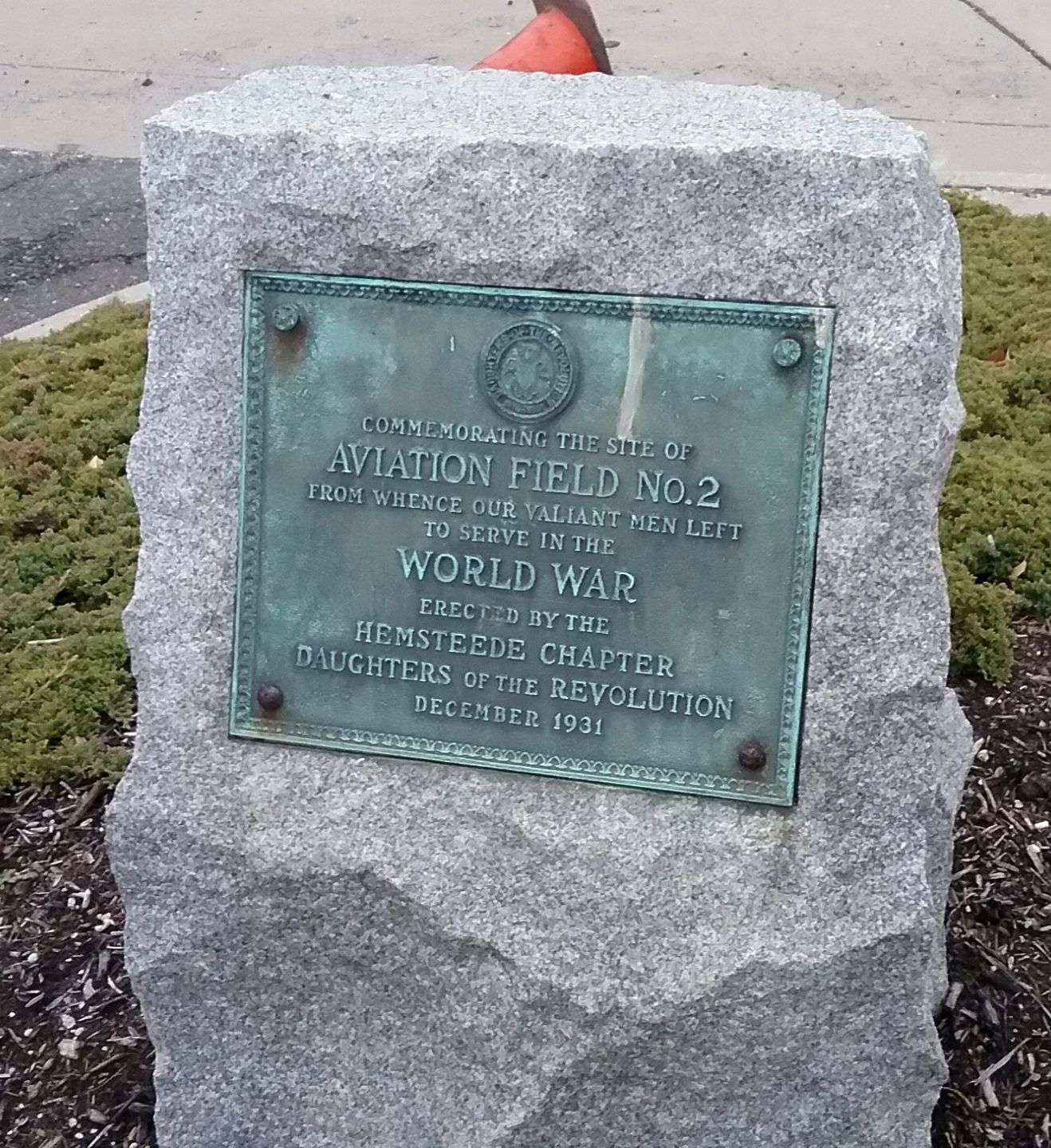
A 3/26/17 photo by Ron Plante of a plaque erected in December 1931 “Commemorating the site of Aviation Field #2” by the Daughters of the Revolution.

A 2018 photo of the plaque situated that year that commemorated Mitchel Field's addition to the National Register of Historic Places.
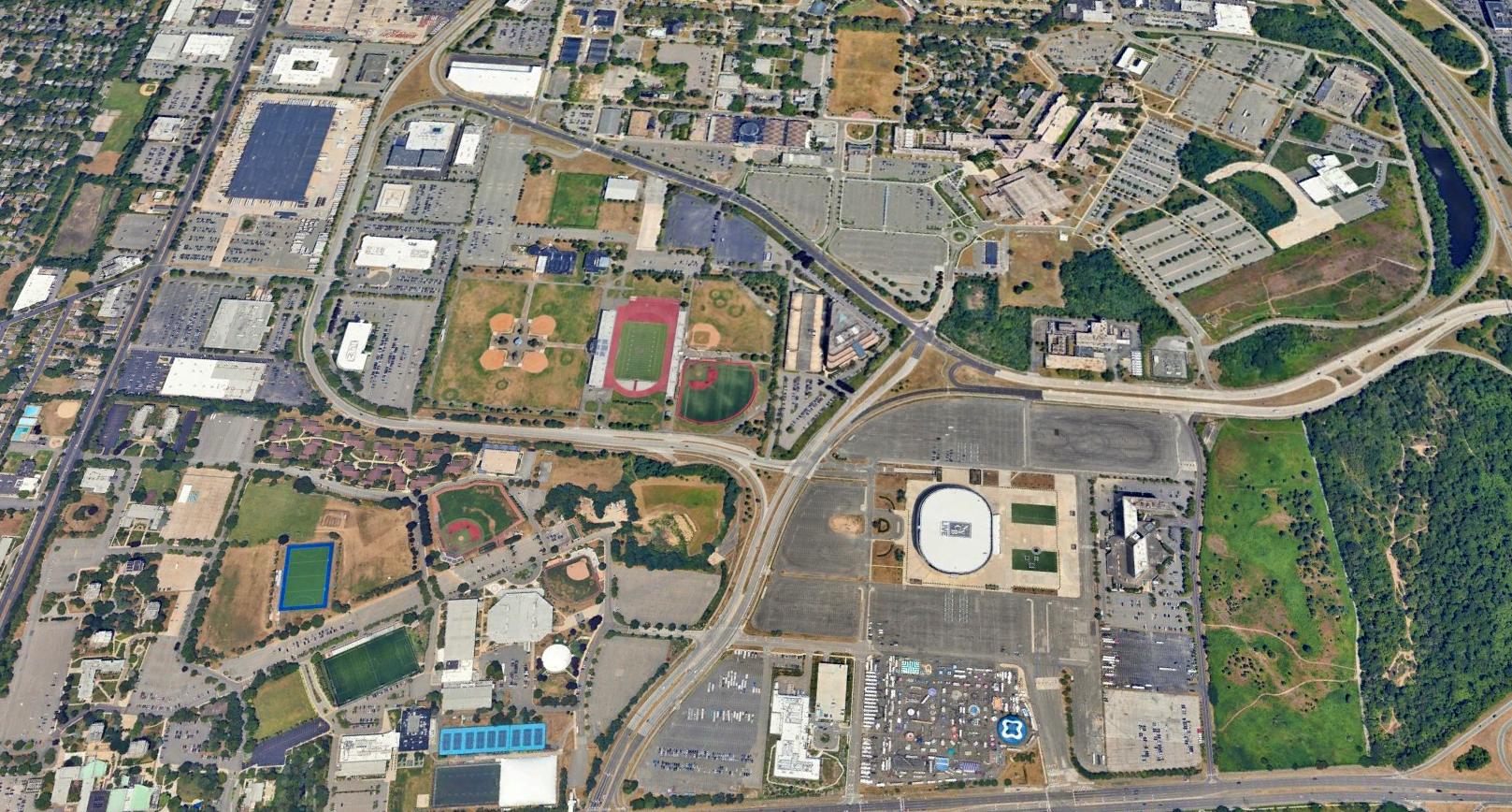
A 2023 aerial view looking northwest at the Mitchel Field site showed the last remaining portions of Runway 5/23 were visible in the NE & SW corners.
See also:
http://pirs.mvr.usace.army.mil/fuds/C02NY064503/21.pdf
http://www.hnd.usace.army.mil/OEW/factshts/factshts/mitchel.pdf
________________________________________________
Or if you prefer to contact me directly concerning a contribution (for a mailing address to send a check),
please contact me at: paulandterryfreeman@gmail.com
If you enjoy this web site, please support it with a financial contribution.
____________________________________________________
This site covers airfields in all 50 states.