Abandoned & Little-Known Airfields:
Florida: Fort Myers area
© 2002, © 2026 by Paul Freeman. Revised 2/25/26.
This site covers airfields in all 50 states: Click here for the site's main menu.
____________________________________________________
Please consider a financial contribution to support the continued growth & operation of this site.
Alva Airfield (added 2/28/16) - Buckingham AAF / Lehigh West / Buckingham Field (revised 3/16/18) - Carlstrom Field (revised 6/16/23) - Casa Ybel Airport / Island Beach Club Airport (revised 7/6/25)
Dorr Field (revised 6/16/23) - Dorr Aux AAF #2 (revised 11/14/19) - Dorr Aux AAF #3 (revised 11/14/19) - Dorr Aux AAF #4 / Bright Hour Ranch Airfield (revised 11/14/19)
Ft. Myers City Airport (added 2/25/26) - Immokalee Intermediate Field (revised 6/16/23) - Lehigh Acres Airpark (revised 6/21/15) - Marco Beach Airport (1st location) (added 5/4/22)
Marco Beach Airport (2nd location) (added 5/4/22) - Myrtle Field / Carlstrom Aux AAF #3 (revised 11/14/19) - Remuda Ranch Airfield / Port of the Islands Airfield (revised 7/7/25)
Southwest Aux AAF #4 (revised 11/14/19) - Wells Aux AAF #2 (revised 11/14/19)
____________________________________________________
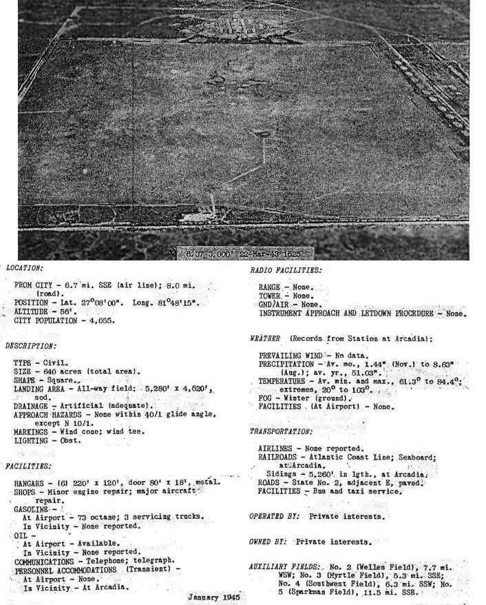
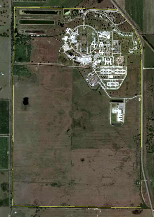
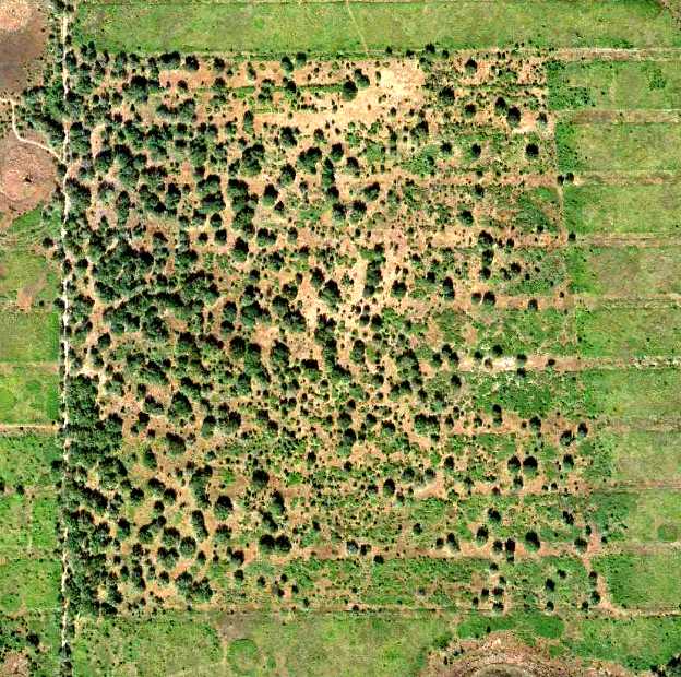
Ft. Myers City Airport, Ft. Myers, FL
26.6313, -81.854 (Southeast of Downtown Ft. Myers, FL)
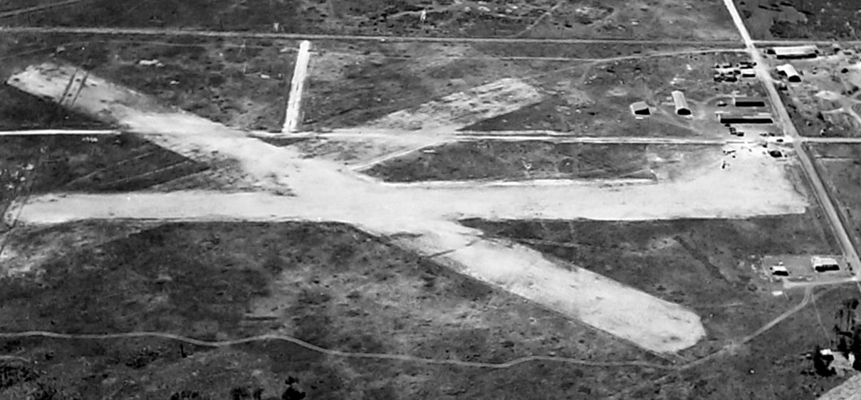
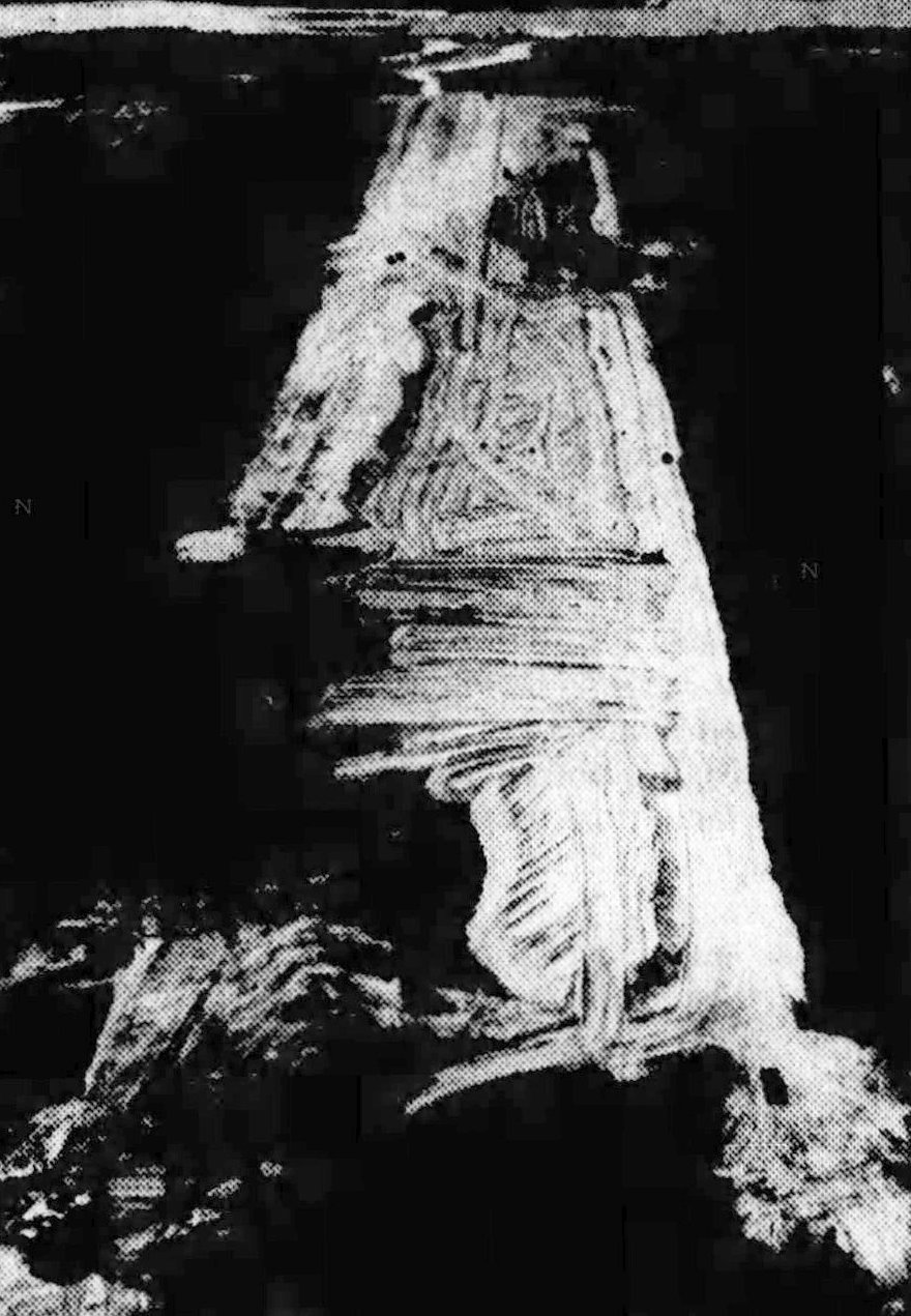
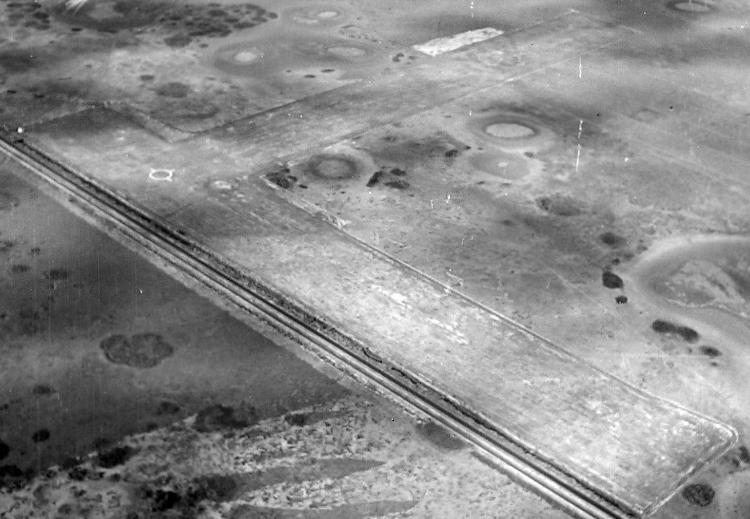
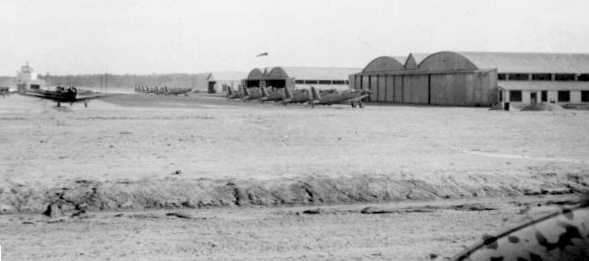
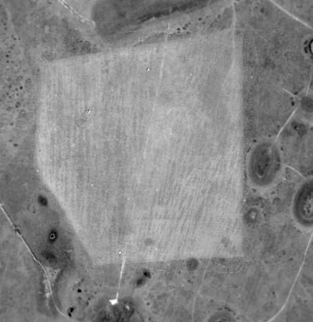
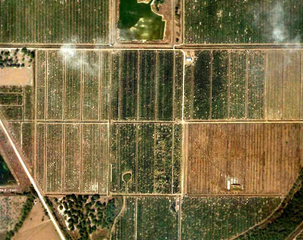
Ft. Myers City Airport, as depicted on a 3/22/43 aerial view looking west (from the National Archives, courtesy of Brian Rehwinkel).
Ft. Myers City Airport was not yet depicted on the July 1940 Miami Sectional Chart.
Brian Rehwinkel reported, “This airport was used for a relatively short period of time during the Second World War to fill in because the city's main airfield - Page Field - was being used by the Army Air Forces.
Although I am not sure when Ft. Myers City Airport was opened, it was most likely in 1942 or early 1943 after Page Field was taken over by the Army Air Forces.
This field was obviously hastily prepared & suitable only for smaller general aviation & was a temporary facility designed to last until the war ended.”
The earliest photo which has been located of Ft. Myers City Airport was a 3/22/43 aerial view looking west (from the National Archives, courtesy of Brian Rehwinkel).
It depicted Ft. Myers City Airport as having 3 unpaved runways, with a few light aircraft near some small buildings on the northwest side.
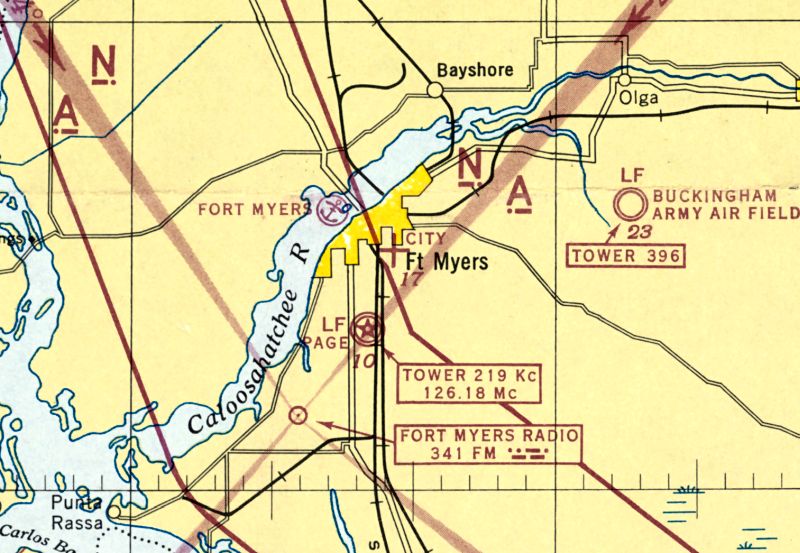
The earliest aeronautical chart depiction which has been located of Ft. Myers City Airport was on the January 1944 Miami Sectional Chart.
It depicted “City” Airport as an auxiliary airfield.
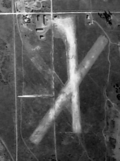
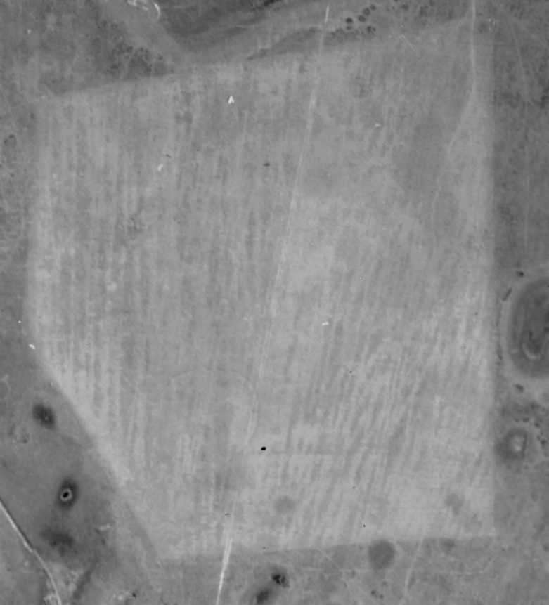
A 1944 aerial view (from the National Archives, courtesy of Brian Rehwinkel) depicted Ft. Myers City Airport as having 3 unpaved runways & some small buildings on the northwest side.
The January 1945 USAAF Airfield Directory (according to Brian Rehwinkel) described Ft. Myers "City Airport" as having 3 sod runways, with the longest being a 2,000' north/south stirp.
The field was said to have 3 hangars & owned by the City of Fort Myers.
The last aeronautical chart depiction which has been located of Ft. Myers City Airport was on the February 1945 Miami Sectional Chart.
It depicted “City” Airport as a commercial/municipal airport.
Ft. Myers City Airport was evidently closed at some point in 1945, lasting no more than 5 years,
as it was no longer depicted on the August 1945 Miami Sectional Chart.
The much larger Page Field had been released to civilian use after the end of WW2, obviating the need for Ft. Myers City Airport.
Brian Rehwinkel reported, “A January 1953 aerial photograph offers no evidence of the field.”
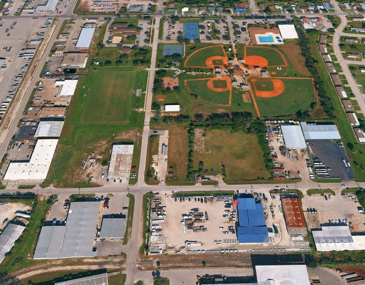
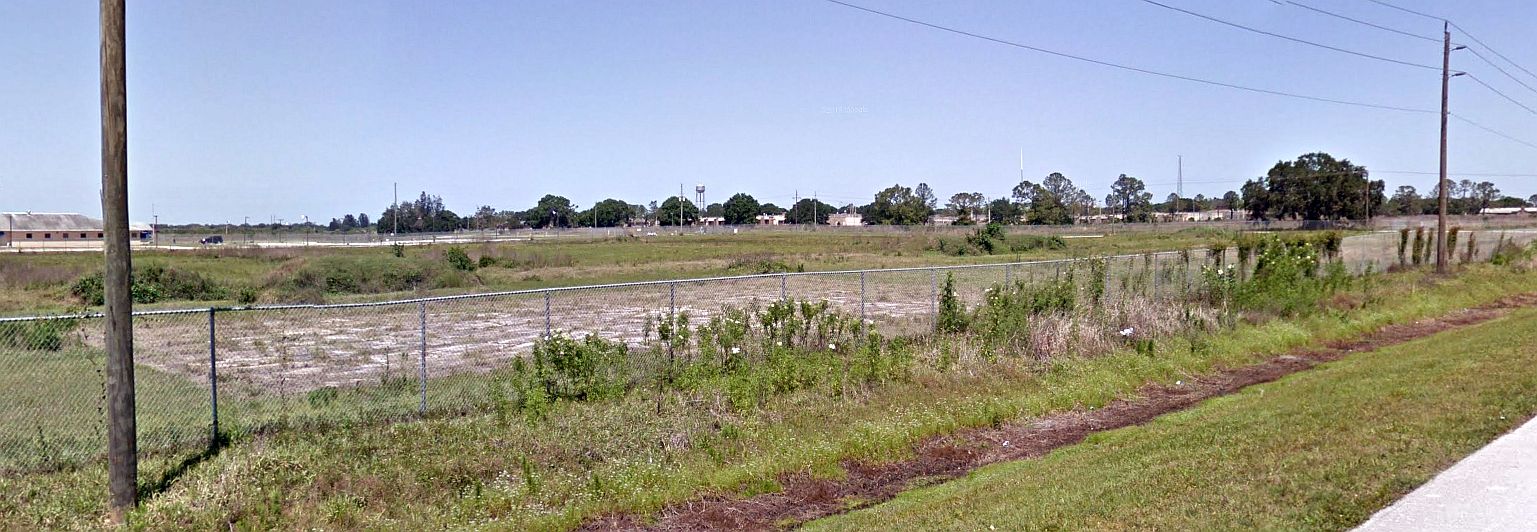
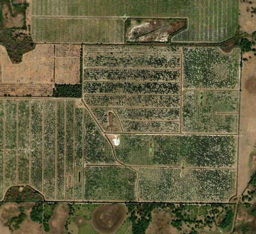
A 2023 aerial view looking north showed no trace remaining of Ft. Myers City Airport.
Brian Rehwinkel reported in 2026, “Today the site of the airfield is occupied by a park complex [Dunbar Park] & some industrial buildings.
So many fast-growing areas (Ft. Myers being no exception) expand so quickly it can be difficult to remember the past. This airfield was a very brief episode in the aviation history of this area.”
____________________________________________________
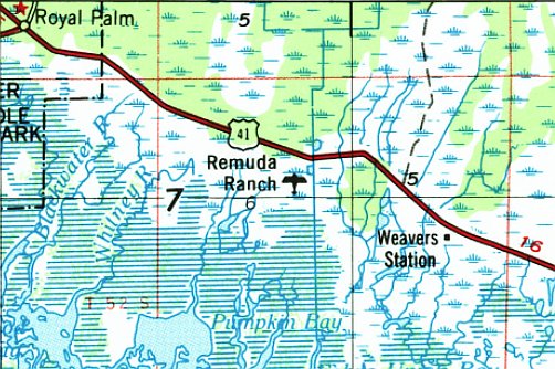
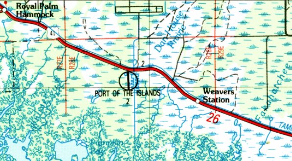
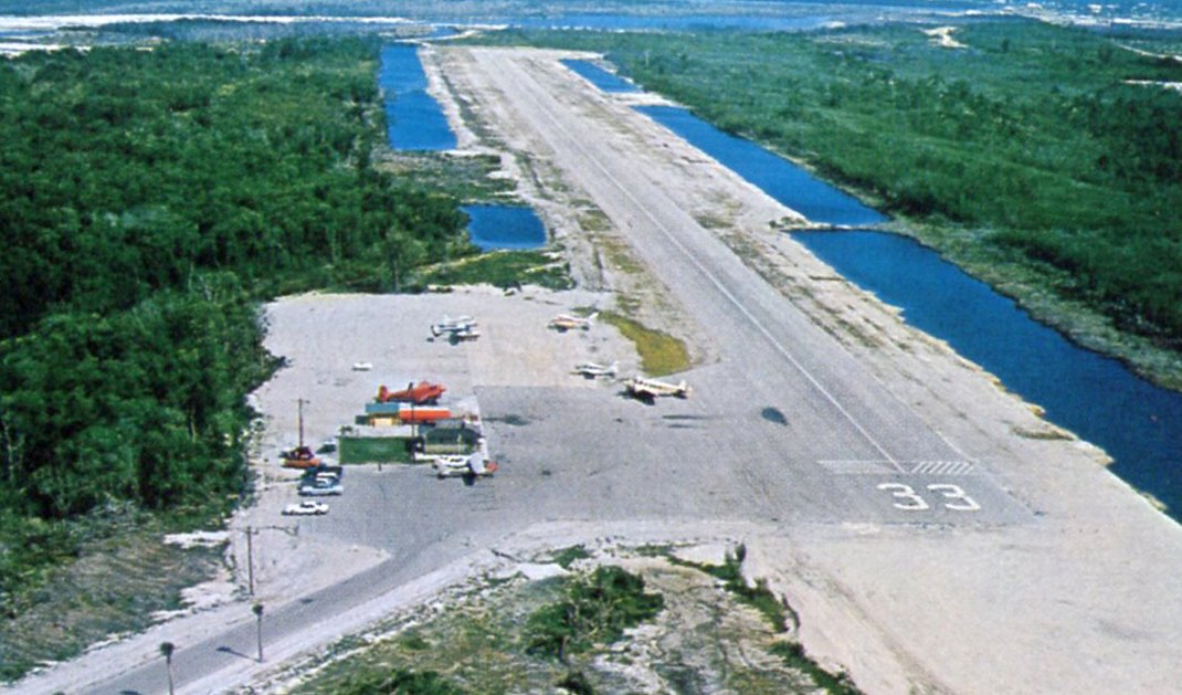
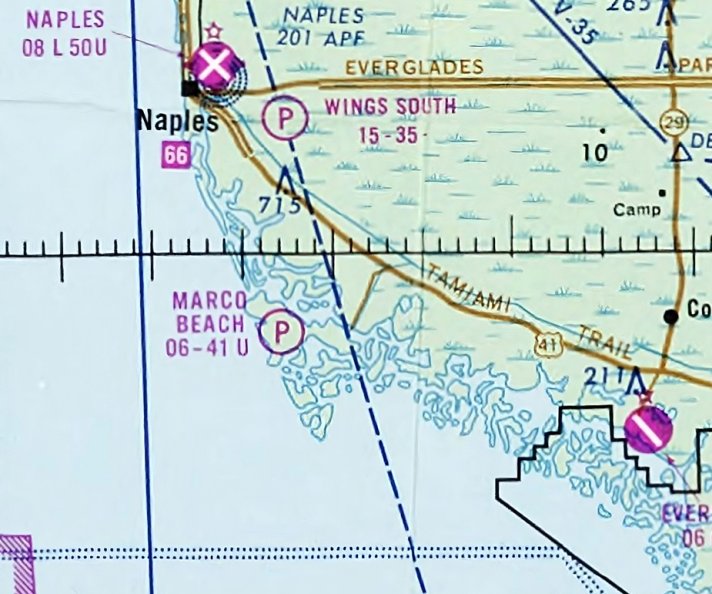
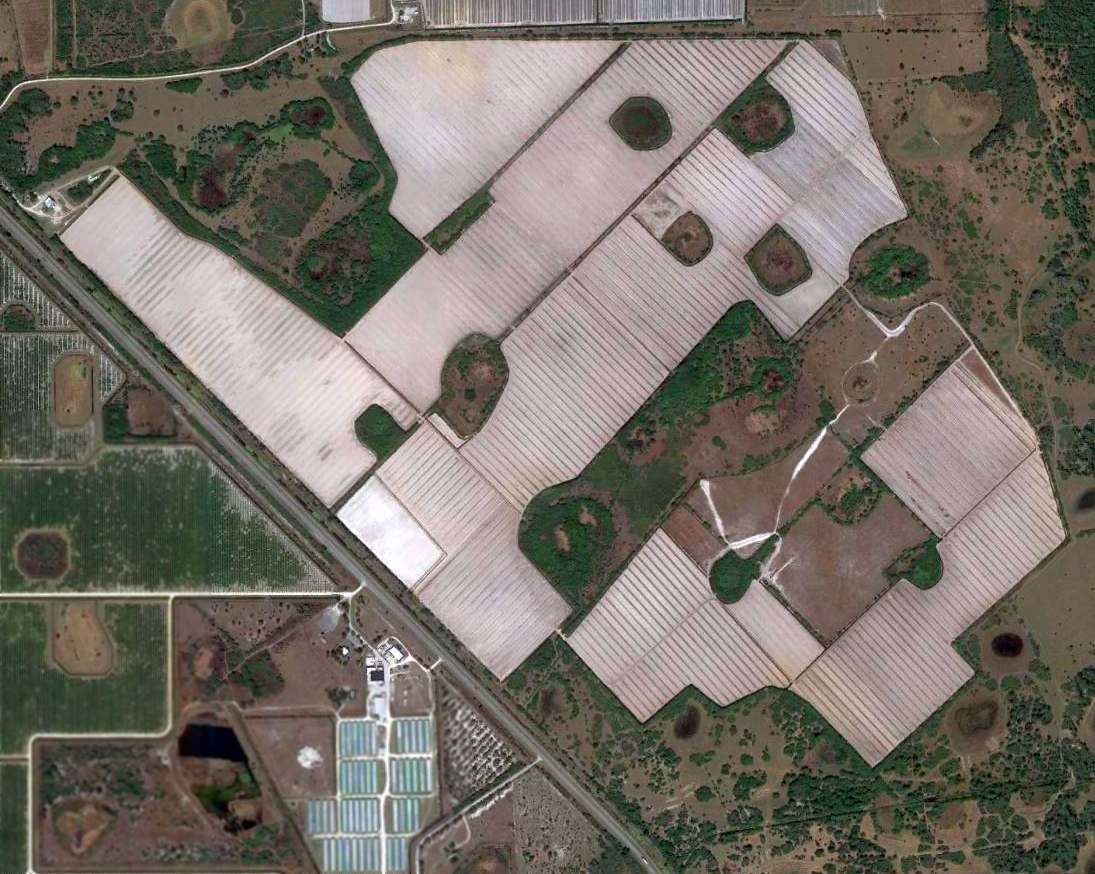
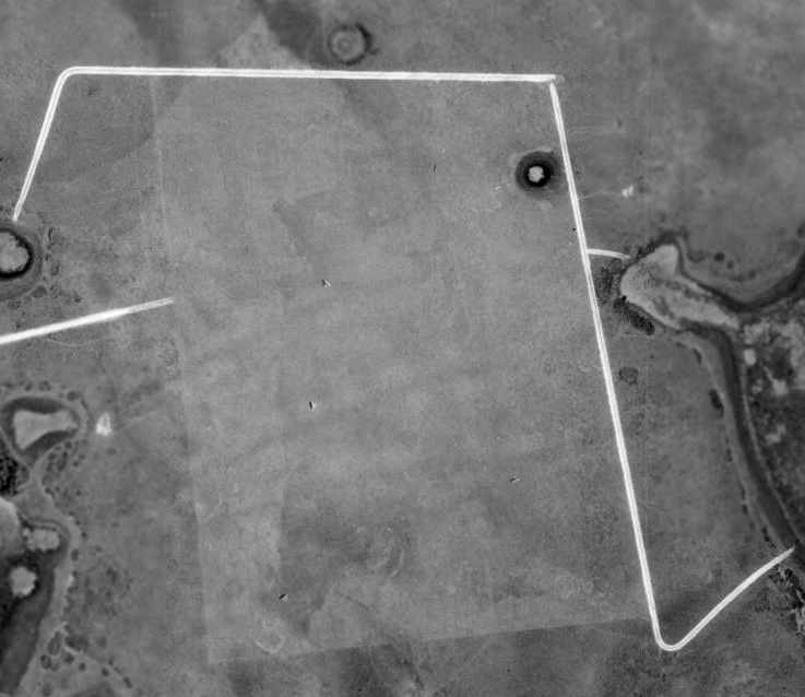
Remuda Ranch Airfield / Port of the Islands Airfield, Naples, FL
25.953, -81.512 (West of Miami, FL)

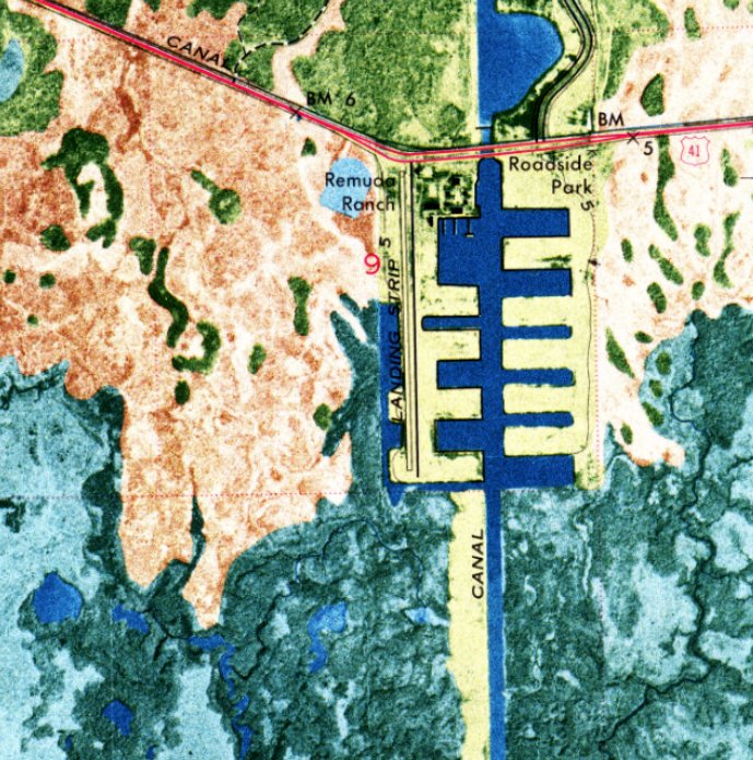
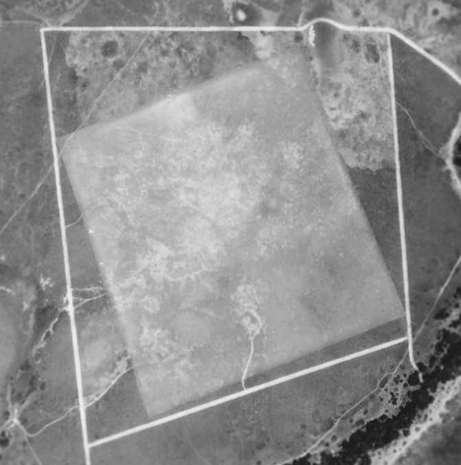
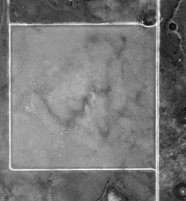
Remuda Ranch Airfield, as depicted on a 10/14/69 USGS aerial photo.
This small airfield was evidently established at some point between 1964-69,
as it was not yet depicted on a 1964 aerial photo.
No airfield was depicted at this location on the 1965 or 1968 Miami Sectional Charts.
The earliest depiction which has been located of Remuda Ranch Airfield was a 10/14/69 USGS aerial photo.
It depicted a single north/south runway, on the western edge of a newly-built residential community.
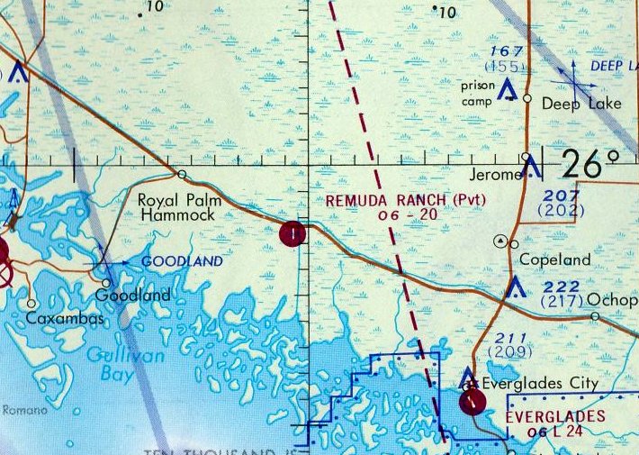
The only aeronautical chart depiction which has been located of Remuda Ranch Airfield was on the 1971 Miami Sectional Chart.
It depicted Remuda Ranch Airfield as a private airfield having a single north/south paved 2,000' runway.
The earliest topo map depiction which has been located of Remuda Ranch Airfield was on the 1971 USGS topo map.
The 1973 USGS topo map depicted Remuda Ranch Airfield as having a single north/south paved runway.
A 1984 aerial photo depicted Remuda Ranch Airfield as having a single north/south runway, possibly paved.
There were no aircraft visible on the airfield.
The Remuda Ranch Airfield was evidently renamed Port of the Islands Airfield at some point between 1971-88,
as that is how it was depicted on the 1988 USGS topo map, with a single north/south paved runway.
Vernon Conly recalled, “I used Port of the Islands Airfield in the late 1980s. It was paved, approximately 3,000' north/south. It served the resort.”
Luca Bencini recalled, “I knew it as Port of the Everglades. I flew in there several times in a Cessna 182 in the 1990s. There was a restaurant as part of the resort.”
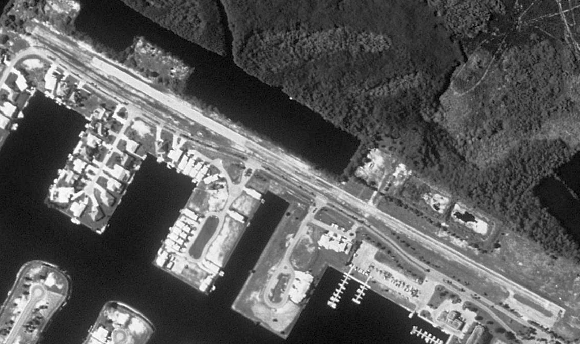
The last photo which has been located showing the Port of the Islands Airfield remaining intact was a 1994 aerial view.
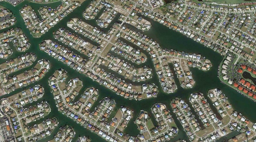
Port of the Islands Airfield was evidently closed at some point between 1994-99,
as a 1999 aerial photo showed several buildings had been built over the southern portion of the runway.
No airfield was depicted at this location on the August 2016 Miami Sectional Chart.
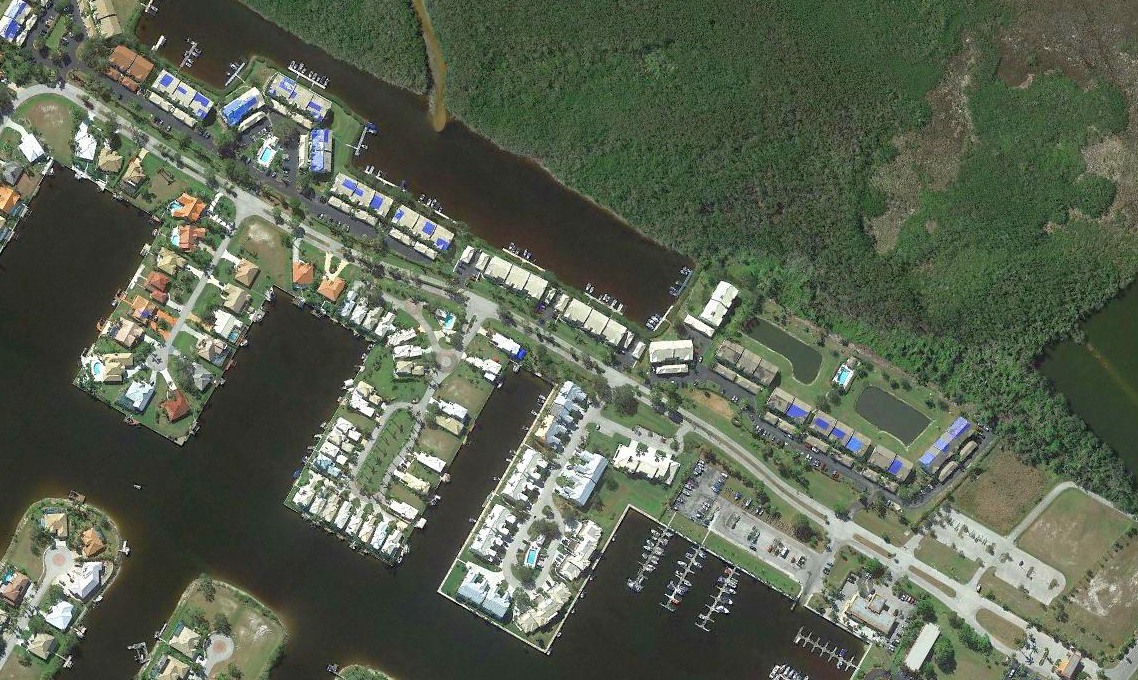
A 20181 aerial view looking southwest showed houses covering the former Port of the Islands Airfield.
Thanks to Vernon Conly for pointing out this airfield.
____________________________________________________
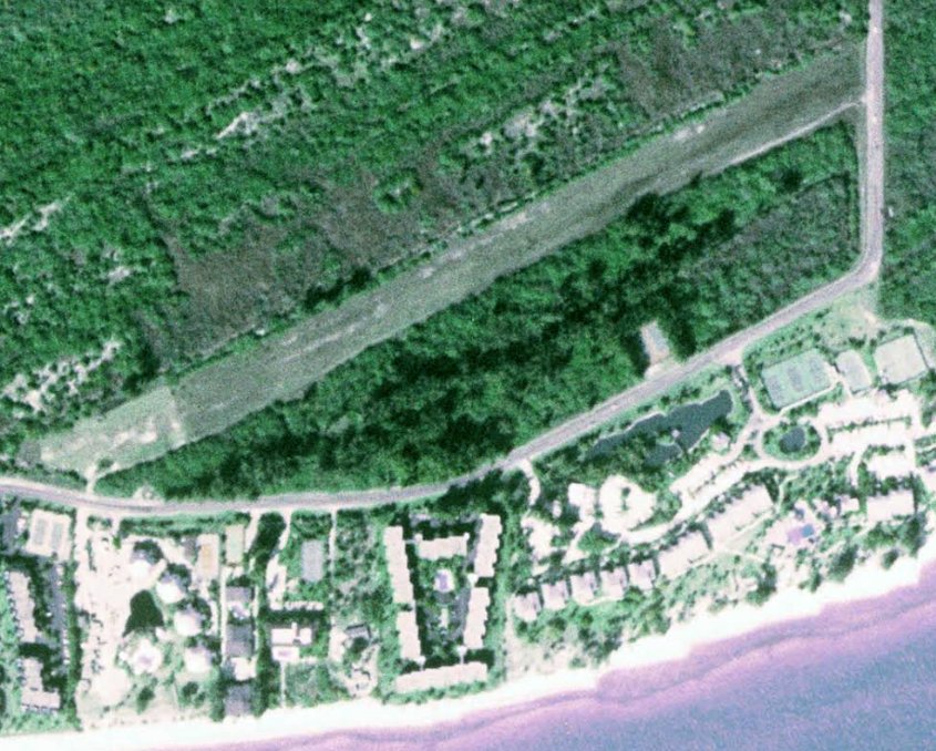
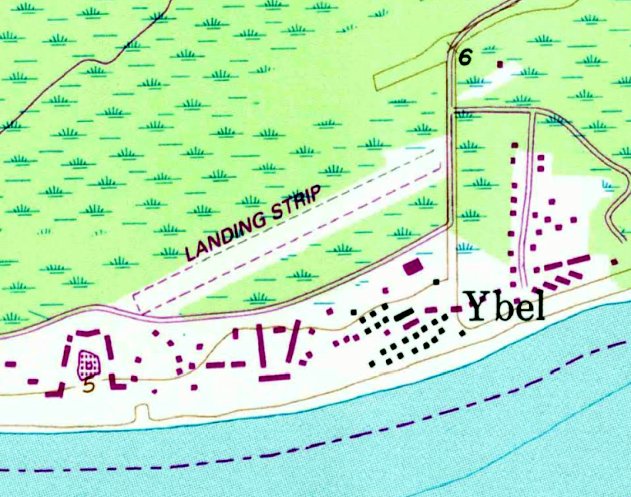
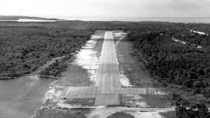
Casa Ybel Airport / Island Beach Club Airport, Sanibel Island, FL
26.427, -82.074 (Southwest of Fort Myers, FL)
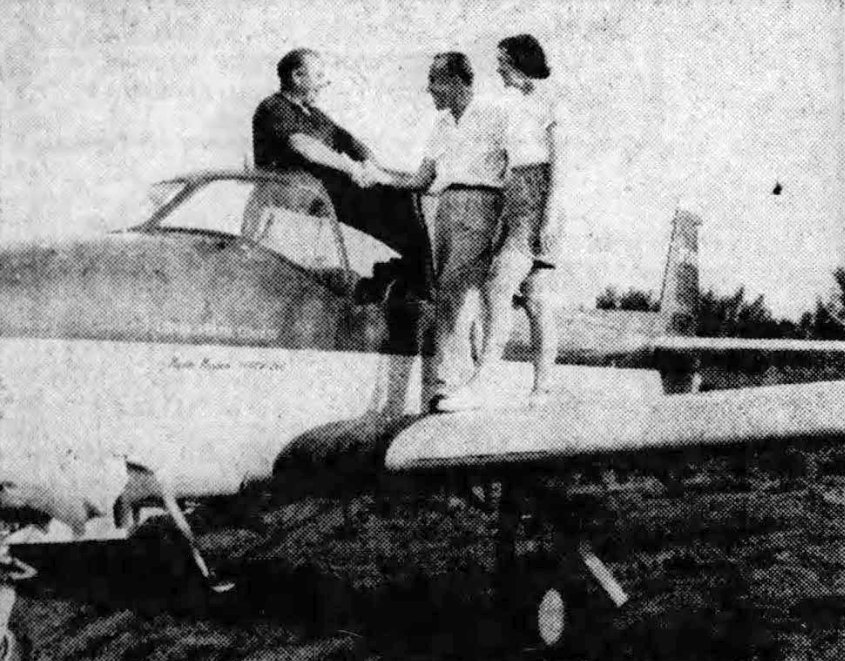
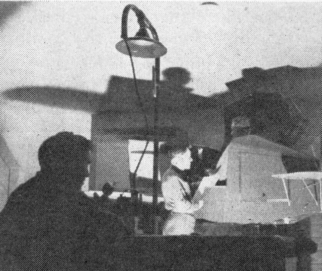
An undated photo from a 10/26/52 article courtesy of David Henderson) showing Mr. & Mrs. Dick Kearns (operators of the Casa Ybel Hotel)
greeting Arnold Larson, pilot of the 1st plane to land on the new Casa Ybel Airport.
A 10/19/52 article (courtesy of David Henderson) entitled “Hotels & clubs opening for season on Sanibel Island” reported,
“The new airstrip & yacht basin are facilities offered by the Casa Ybel hotel.
The airstrip is reported smooth by pilot Arne Larson who landed his 4-passenger private plane there.”
The earliest depiction which has been located of the Casa Ybel Airport was an undated photo from a 10/26/52 article (courtesy of David Henderson)
showing Mr. & Mrs. Dick Kearns (operators of the Casa Ybel Hotel) greeting Arnold Larson,
pilot of the 1st plane to land on the new Casa Ybel Airport.
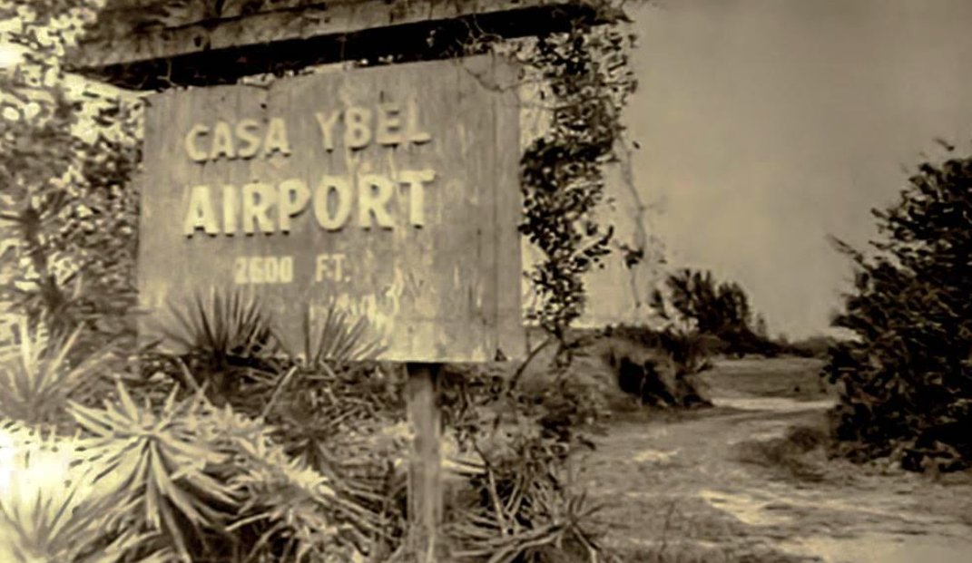
A circa 1950s photo of the Casa Ybel Airport sign (courtesy of David Henderson).
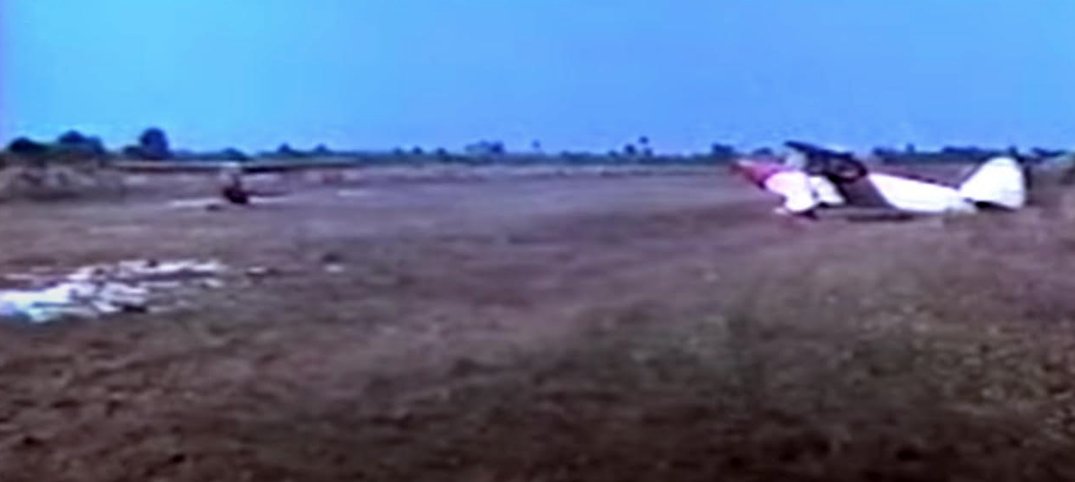
The only images which have been located showing aircraft at the Casa Ybel Airport was a circa 1950s movie “Sanibel Before The Causeway #5” (courtesy of David Henderson),
showing 2 Pipers on an unpaved airfield.
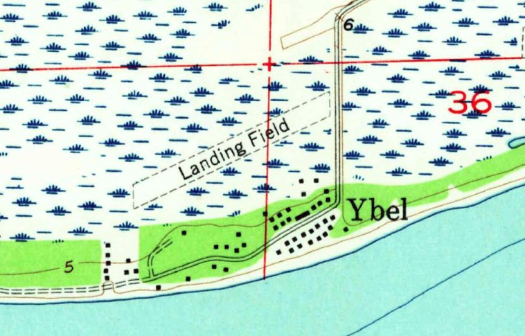
The earliest topo map depiction which has been located of the Casa Ybel Airfield was on the 1958 USGS topo map (courtesy of David Henderson).
It depicted a single unpaved northeast/southwest runway, generically labeled “Landing Field”.
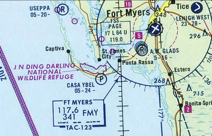
The earliest aeronautical chart depiction which has been located of the Casa Ybel Airport was on the 1969 FL Aeronautical Chart (courtesy of David Henderson).
It depicted Casa Ybel as a private airfield.
A 3/5/72 article (courtesy of David Henderson) reported that the Casa Ybel Hotel had been renamed the Island Beach Club.
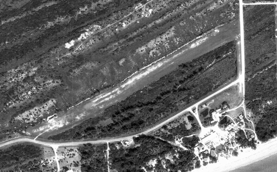
The earliest aerial photo which has been located of the Island Beach Club Airfield was a 3/9/72 aerial view (courtesy of David Henderson).
It depicted a single unpaved northeast/southwest runway. There did not appear to be any buildings or aircraft.

A 1970s aerial view by Mike Jacoby looking northeast on approach to Casa Ybel Airport.
Mike recalled, “My brother & I flew there once or twice in a Cherokee from New Garden, PA. We felt like big-shots taxiing in & tying down there!”
The last aeronautical chart depiction which has been located showing the Island Beach Club Airfield in operation was on the 1976 FL Aeronautical Chart (courtesy of David Henderson).
It depicted Island Beach Club as a private airfield.
The Island Beach Club Airfield was evidently closed at some point between 1976-79,
as it was depicted as “Closed” on the 1979 FL Aeronautical Chart (courtesy of David Henderson).
The last photo which has been located showing the Island Beach Club Airfield remaining intact was a 1984 aerial view (courtesy of David Henderson).
The 1987 USGS topo map (courtesy of David Henderson) depicted the Island Beach Club Airfield in the same fashion as the 1958 topo.
A 1996 aerial view showed that the former Island Beach Club Airfield runway remained recognizable, but 2 houses had been built over the runway at some point between 1984-96.
A 2021 aerial view showed that houses had covered all of the former Island Beach Club Airfield.
Thanks to David Henderson for pointing out this airfield.
____________________________________________________
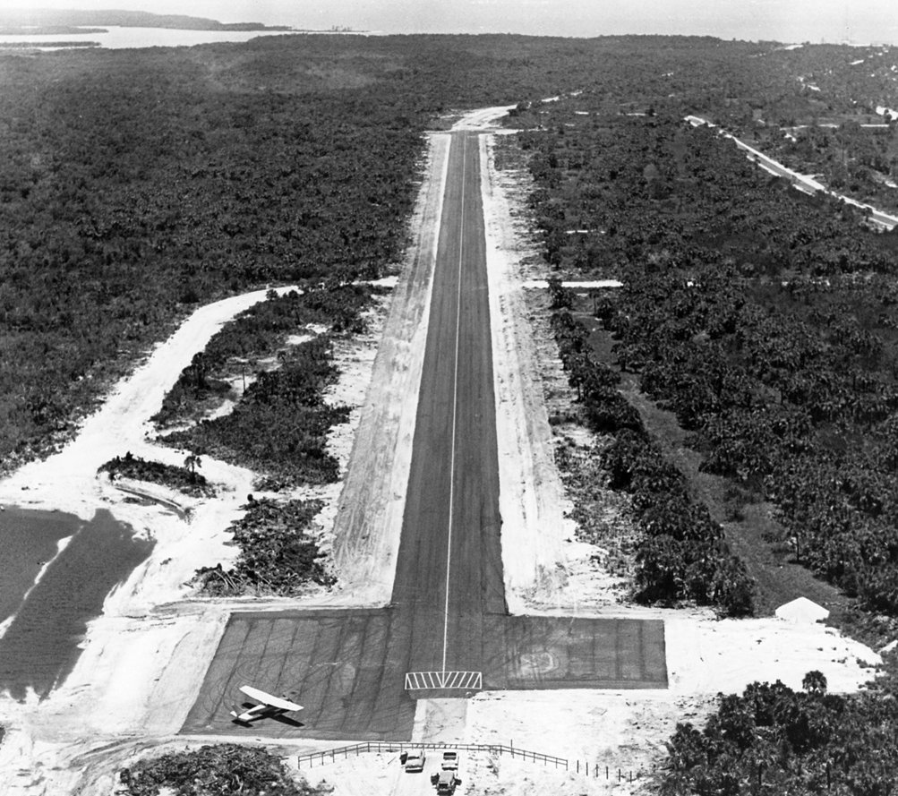
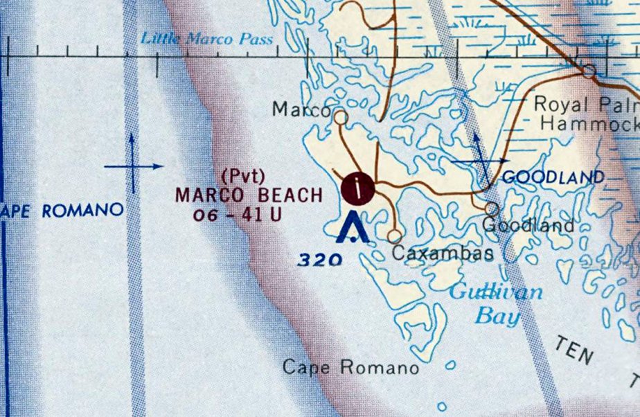
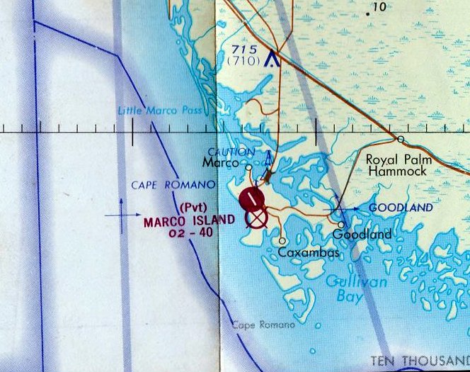
Marco Beach Airport (1st location), Marco Island, FL
25.929, -81.725 (South of Fort Myers, FL)
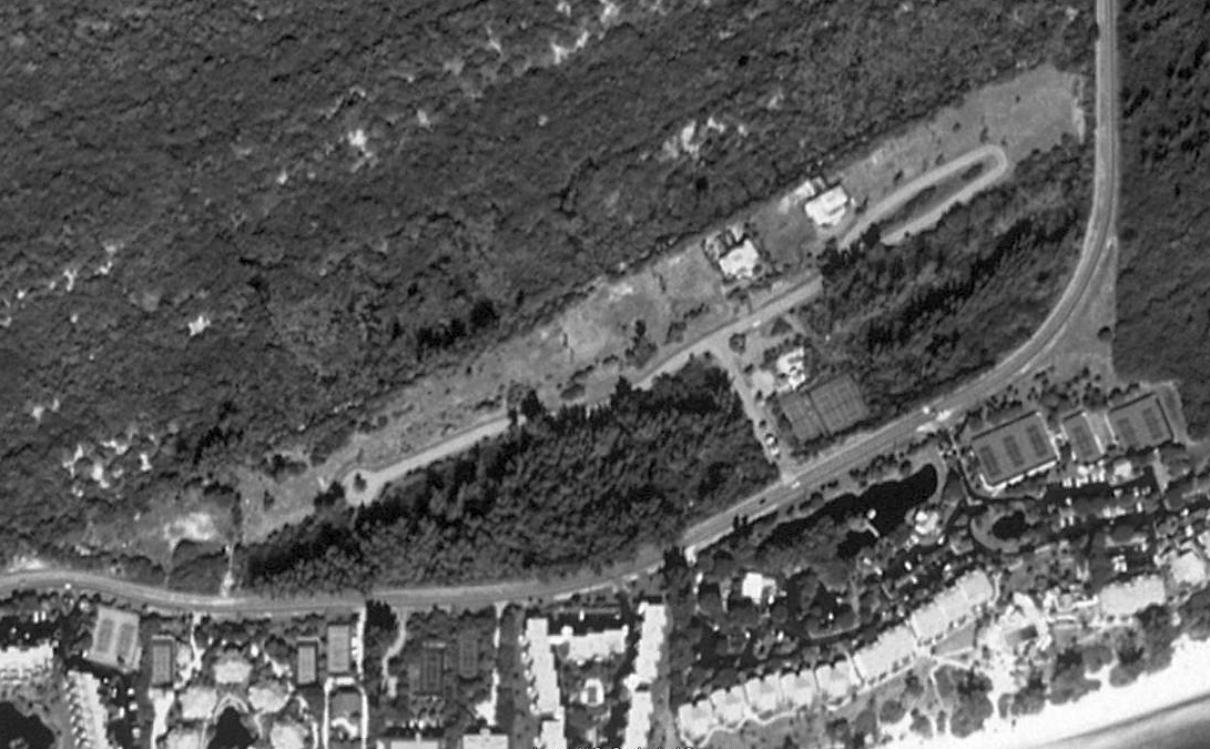
A June 1965 aerial view looking north at the site of Marco Beach Airport (courtesy of the Marco Island Historical Society, via David Henderson).
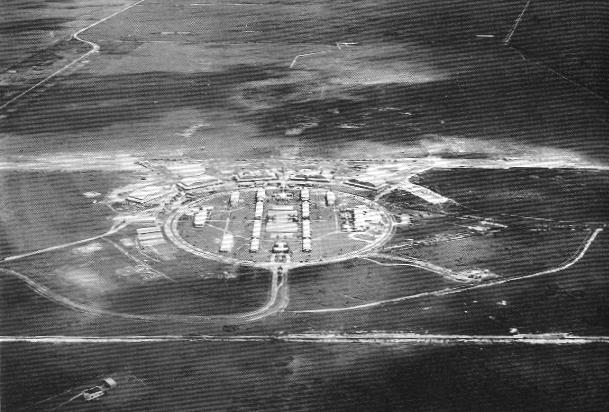
David Henderson reported, “Marco Island is a small barrier island on the Gulf of Mexico in southwest FL, and was home to 2 temporary airstrips, both built in the 1960s.
In 1964, the Deltona Corporation announced a half-billion dollar development plan to transform the 25 square mile tropical island into a high-density resort community.
One of the first projects was the construction of a temporary airstrip, built on a section of road that led to an abandoned Cold War-era missle tracking station.
A borrow pond was dredged at the north end of the strip & provided fill dirt to widen the road into a runway which ran parallel to the beach.
The airport served 2 important purposes for the developers: to bring prospective buyers & tourists to the Deltona sales office & the new Marco Beach resort, both located 2 blocks away.
The airstrip was completed in the spring of 1965.”
The earliest image which has been located of the Marco Beach Airport was a June 1965 aerial view (courtesy of the Marco Island Historical Society, via David Henderson).
It depicted a single northwest/southeast runway.
The earliest aeronautical chart depiction which has been located of the Marco Beach Airport was on the September 1965 Miami Sectional Chart (courtesy of David Henderson).
It depicted Marco Beach Airport as a private airfield having a single paved northwest/southeast 3,200' paved runway.
David Henderson reported, “Naples Airlines added Marco Island as a stop on its Miami - Ft. Myers route on 12/1/65 using vintage Lockheed Model 10 Electras.”
A 1965 aerial view looking south along the Marco Beach Airport runway (courtesy of the Marco Island Historical Society, via David Henderson)
showed 1 single-engine Cessna on the adjacent ramp.
A 1965 aerial view looking southwest at the ramp on the south end of the Marco Beach Airport runway (courtesy of the Marco Island Historical Society, via David Henderson).
David Henderson reported, “The runway was extended to the south by roughly 900' sometime in 1966.”
An undated aerial view from a 9/18/66 article (courtesy of the Marco Island Historical Society, via David Henderson) looking southwest at Marco Beach Airport.
A 1967 aerial view looking south along the Marco Beach Airport runway (courtesy of the Marco Island Historical Society, via David Henderson).
The last aeronautical chart depiction which has been located of the 1st location of the Marco Beach Airport was on the September 1967 Miami Sectional Chart (courtesy of David Henderson).
It depicted Marco Beach Airport as a private airfield having a single paved northwest/southeast 4,100' paved runway.
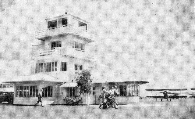
A circa 1968 aerial view looking north at Marco Beach Airport (courtesy of the Marco Island Historical Society, via David Henderson).
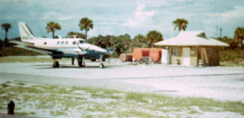
A circa 1968 photo of the Queen Air Queen Air (belonging to the Mackle brothers, heads of the Deltona Corporation development company)
parked next to the Marco Beach Airport terminal (courtesy of the Marco Island Historical Society, via David Henderson).
David Henderson reported, “The airport was closed in the fall of 1968 & operations were moved to a new airstrip located at the center of the island, less than a half mile to the northeast.
The old site was immediately redeveloped into a residential area.”
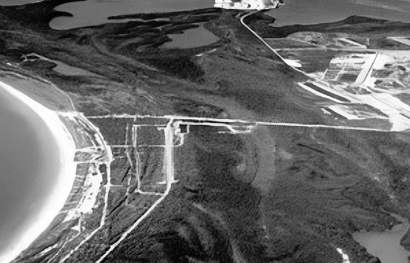
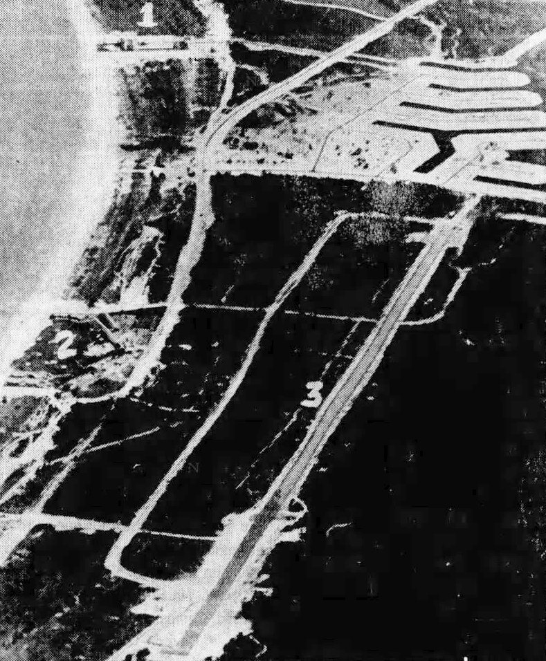
A circa 1969 aerial view looking northwest (courtesy of the Marco Island Historical Society, via David Henderson) at the site of the 1st Marco Beach Airport (highlighted in red)
and the 2nd Marco Beach Airport to the northeast (top-right).
The 1st Marco Beach Airport was depicted as an abandoned airfield on the 1971 Miami Sectional Chart.
A 2018 aerial view looking northwest showed no trace of the 1st Marco Beach Airport, now covered by dense houses along Landmark Street.
Thanks to David Henderson for pointing out this airfield.
____________________________________________________
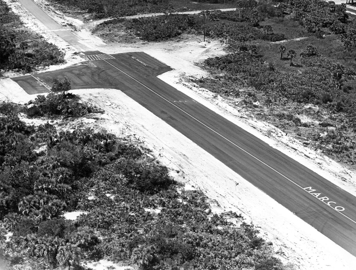
Marco Beach Airport (2nd location), Marco Island, FL
25.945, -81.725 (South of Fort Myers, FL)
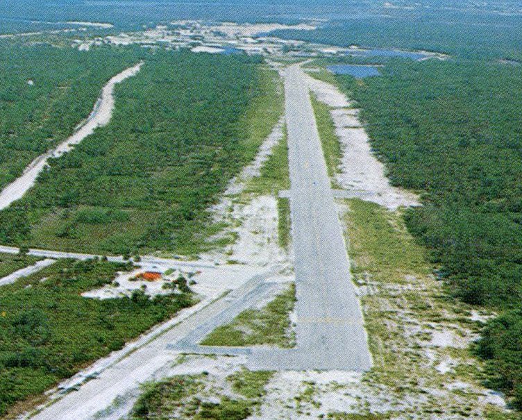
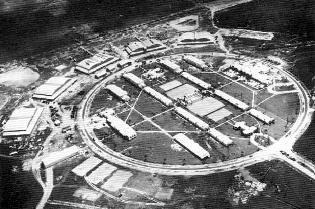
An undated aerial view from a 5/29/68 article (courtesy of the Marco Island Historical Society, via David Henderson) showing the 2nd Marco Beach Airport under construction.
David Henderson reported, “A second airport was constructed on Marco Island in 1968, replacing the temporary runway constructed near the beach in 1965.
The layout of the new airport was virtually identical to the previous one, with a 4,100' runway & a small terminal on the southwest corner of the field.
The runway was built on fill dirt dredged from the runway borders.
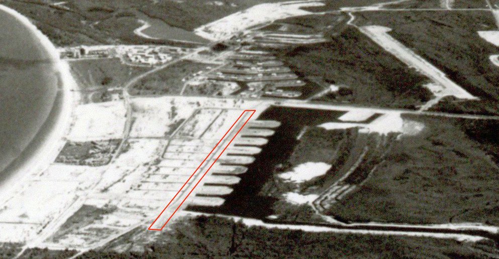
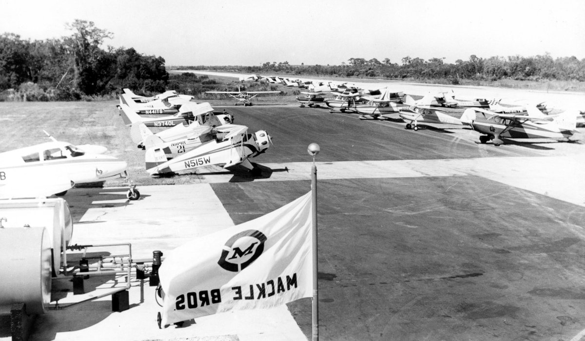
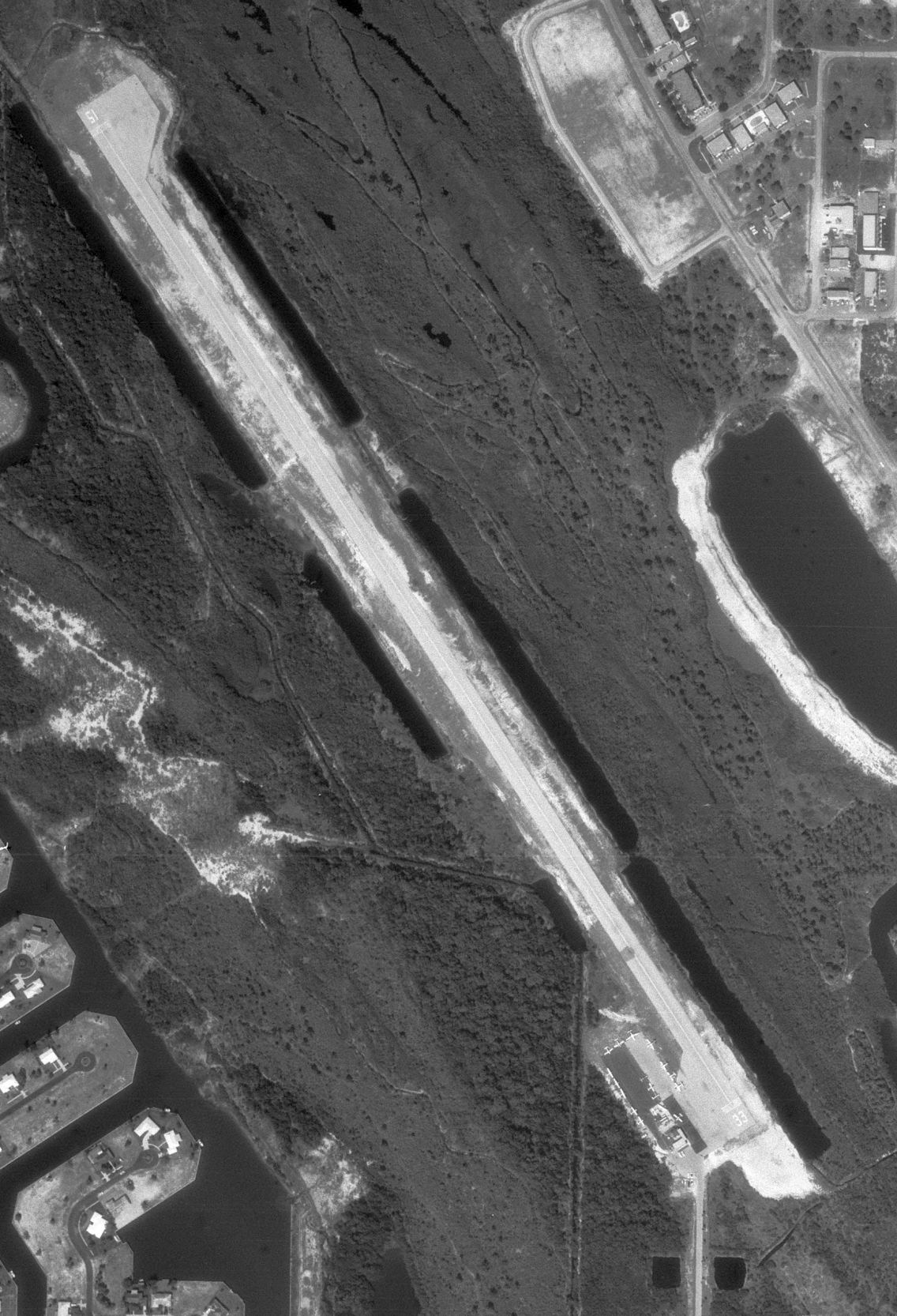
A circa 1968 aerial view looking north at the new 2nd Marco Beach Airport (courtesy of the Marco Island Historical Society),
showing 6 light aircraft parked near a small terminal on the southeast side of the paved Runway 33.
A 12/13/69 aerial view (courtesy of the Marco Island Historical Society) showed the 2nd Marco Beach Airport
to have 13 light aircraft parked near a small terminal on the southeast side of the paved Runway 33.
A circa 1969 photo (courtesy of the Marco Island Historical Society) showed a large number of light aircraft at the 2nd Marco Beach Airport.
David Henderson noted, “The flag in the foreground... The Mackle Brothers were heads of the Deltona Corporation, the primary real estate developer of Marco Island.”
A circa 1969 aerial view looking northwest (courtesy of the Marco Island Historical Society, via David Henderson) at the site of the 1st Marco Beach Airport (highlighted in red)
and the 2nd Marco Beach Airport to the northeast (top-right).

A circa 1970 aerial view looking northeast (courtesy of the Marco Island Historical Society) showed the site of the 1st Marco Beach Airport in the foreground
and the new 2nd Marco Beach Airport at top-left.
The 1971 Miami Sectional Chart depicted the 2nd Marco Beach Airport as having a single 4,000' paved northwest/southeast runway,
and depicted the 1st Marco Beach Airport as an abandoned airfield.
David Henderson reported, “Naples Airlines & Executive Airlines both served Marco Island in the early 1970s.
American Air Taxi (AAT Airlines) inaugurated Marco Island service on 1/6/72 with 3 round trips to Miami using de Havilland DH-114 Herons.”
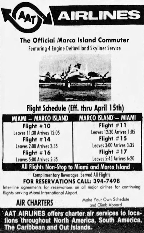
A 1/28/72 schedule for AAT Airlines' service to Marco Island (courtesy of David Henderson).
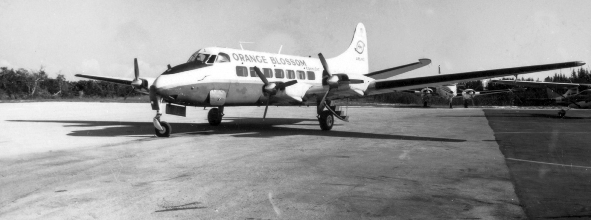
A February 1972 photo by Bryan Donaldson of de Havilland DH-114 Heron N510FW "Orange Blossom Commuter" on the ramp at Marco Beach Airport (courtesy of the Marco Island Historical Society).
David Henderson reported, “The Deltona Corporation formed its own subsidiary airline Marco Island Airways in 1972 to bring tourists to its burgeoning developments.
Flights between Marco & Miami began on 10/1/72 using Beechcraft B-99s.
Deltona also owned the airport & banned other airlines from using the field from that point on.”
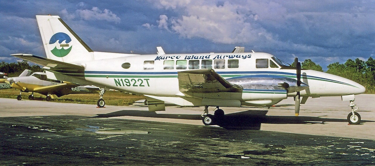
A 1972 photo of a Marco Island Airways Beech 99 (courtesy of David Henderson).
David Henderson reported, “Traffic on the Marco-Miami route was so strong that Marco Island Airways purchased several 40-passenger Martin 404s from Southern Airways to handle the growing crowds,
especially during the peak winter tourist months.
An addition to the original hut-like terminal included a large waiting room.”
A 1973 aerial view (courtesy of the Marco Island Historical Society) showed the 2nd Marco Beach Airport to have
a large number of light aircraft parked near a small terminal on the southeast side of the paved Runway 33.
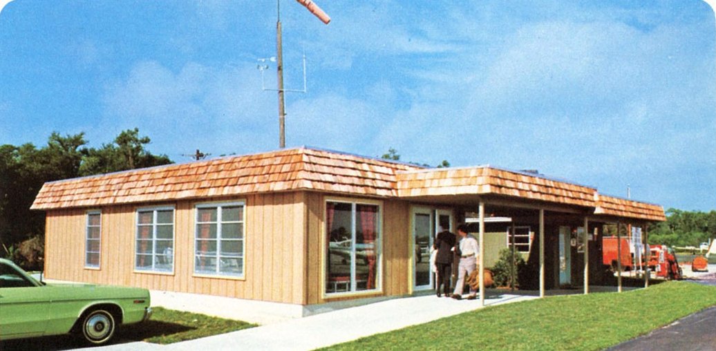
A 1973 photo (courtesy of the Marco Island Historical Society) of the 2nd Marco Beach Airport terminal.
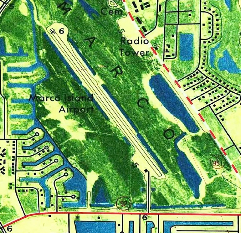
The 1973 USGS topo map (courtesy of David Henderson) showed the 2nd Marco Beach Airport to have a paved northwest/southeast paved runway with a small building on the southwest side.

1975 photo (courtesy of Thresa Todd) of Marco Island Airways stewardesses modeling the latest inflight fashions on the wing of a Martin 404.
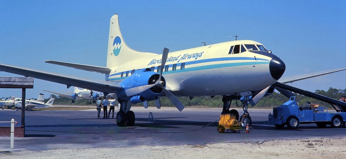
1976 photo (from the Sunshine Skies collection) of Marco Island Airways Martin 404 at the terminal with a 2nd Martin taking off in the background.
David Henderson reported, “Construction of the 3rd (and current) Marco Island airport began on the mainland north of the island in 1972.”
The last aeronautical chart depiction which has been located of the 2nd Marco Beach Airport was on a 1976 aeronautical chart (courtesy of David Henderson).
It depicted Marco Beach Airport as a private airfield having a 4,100' runway.
David Henderson reported, “Marco's 2nd airport closed when the new facility opened in September 1976.
The former airport site was immediately redeveloped as an extensive dredge-&-fill residential area.”
A 1984 aerial photo showed no trace of the 2nd Marco Beach Airport, with the site covered by houses & canals.
A 2018 aerial view looking northeast showed no trace of the 2nd Marco Beach Airport, now covered by houses & canals
Thanks to David Henderson for pointing out this airfield.
____________________________________________________
26.734, -81.701 (East of Fort Myers, FL)
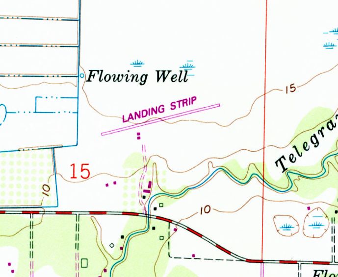
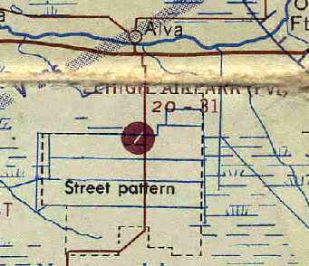
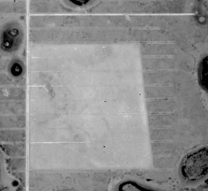
Alva Airfield, as depicted on the 1987 USGS topo map.
Not much is known about this little airfield, including its name.
The Alva Airfield was evidently established at some point between 1980-87,
as it was not yet depicted on the 1974 USGS topo map September 1980 Miami Sectional Chart (courtesy of Mitchell Hymowitz).
The earliest depiction which has been located of this airfield was on the 1987 USGS topo map,
which depicted a single paved northeast/southwest runway, labeled simply as “Landing Strip”,
with 2 small buildings on the south side.
Peter Miller reported, “Alva Airport was privately owned by Dr. Simone; he had a large ranch in that whole northeast corner off Route 78.
He had a Bonanza that he flew out of there. After he passed away, his widow X’d off the runway.”
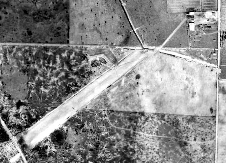
The earliest photo which has been located of the Alva Airfield was a 1994 USGS aerial view looking northeast.
It depicted an 1,800' asphalt northeast/southwest runway, with a ramp & a small hangar on the south side.
Both runway ends were already marked with closed-runway “X” symbols.
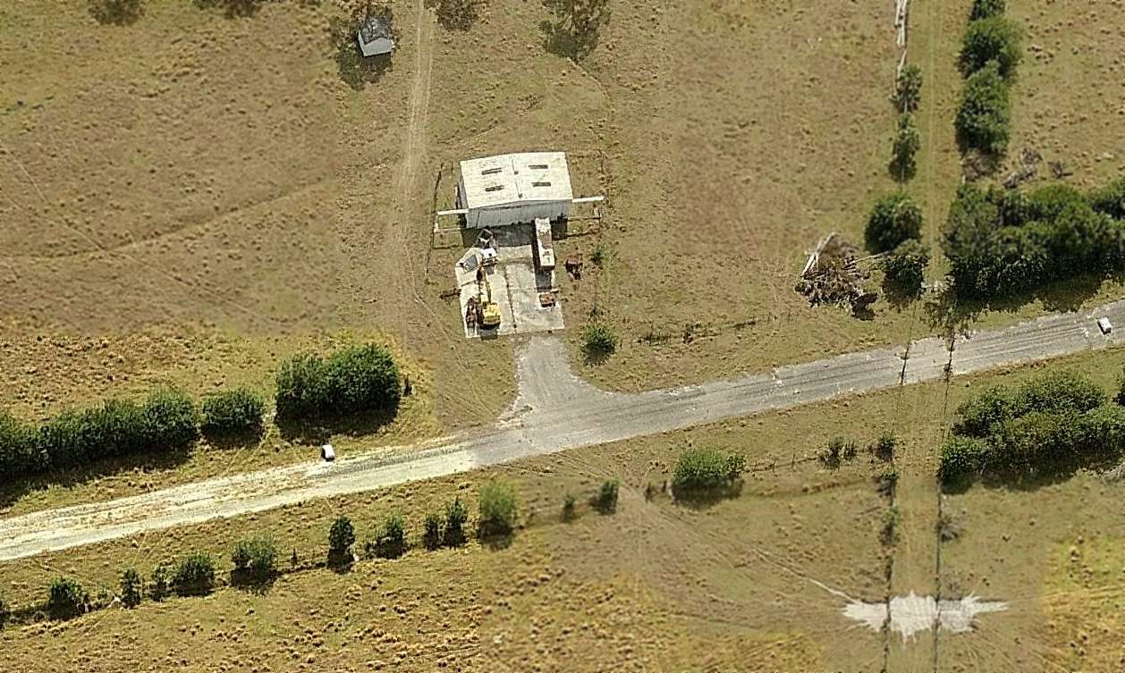
A circa 2010 aerial view looking south at the Alva Airfield showed construction equipment being stored on the ramp in front of the hangar.
The runway remained intact though deteriorated.
A 2014 aerial view looking northeast showed the Alva Airfield to remain intact though further deteriorated.
The site of Alva Airfield is located northwest of the intersection of North River Road & Telegraph Creek Lane.
Thanks to Alex Nelon for pointing out this airfield.
____________________________________________________
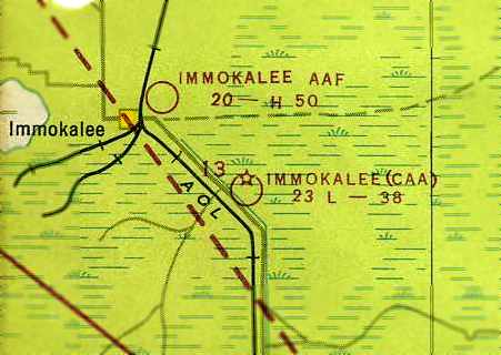
Immokalee Intermediate Field, Immokalee, FL
26.37, -81.355 (East of Fort Myers, FL)
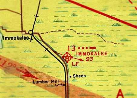
Immokalee Intermediate Field, as depicted on the September 1942 Miami Sectional Chart (courtesy of Chris Kennedy).
This airfield was constructed as one of the Department of Commerce's network of Intermediate Fields,
established for the emergency use of commercial aircraft flying along airways between major cities.
Immokalee Intermediate Field was evidently established at some point between 1938-41,
as it was not yet listed among active airfields in The Airport Directory Company's 1938 Airport Directory (according to Chris Kennedy).
The earliest reference to the field which has been located
was in The Airport Directory Company's 1941 Airport Directory (courtesy of Chris Kennedy).
It described Immokalee as the Civil Aeronautics Administration's Site 13 along the Tampa-Miami Airway.
The field was said to consist of two 3,800' runways in an “L” shape, oriented northwest/southeast & northeast/southwest.
The field was said to have a beacon tower in the northwest corner, but to offer no services.
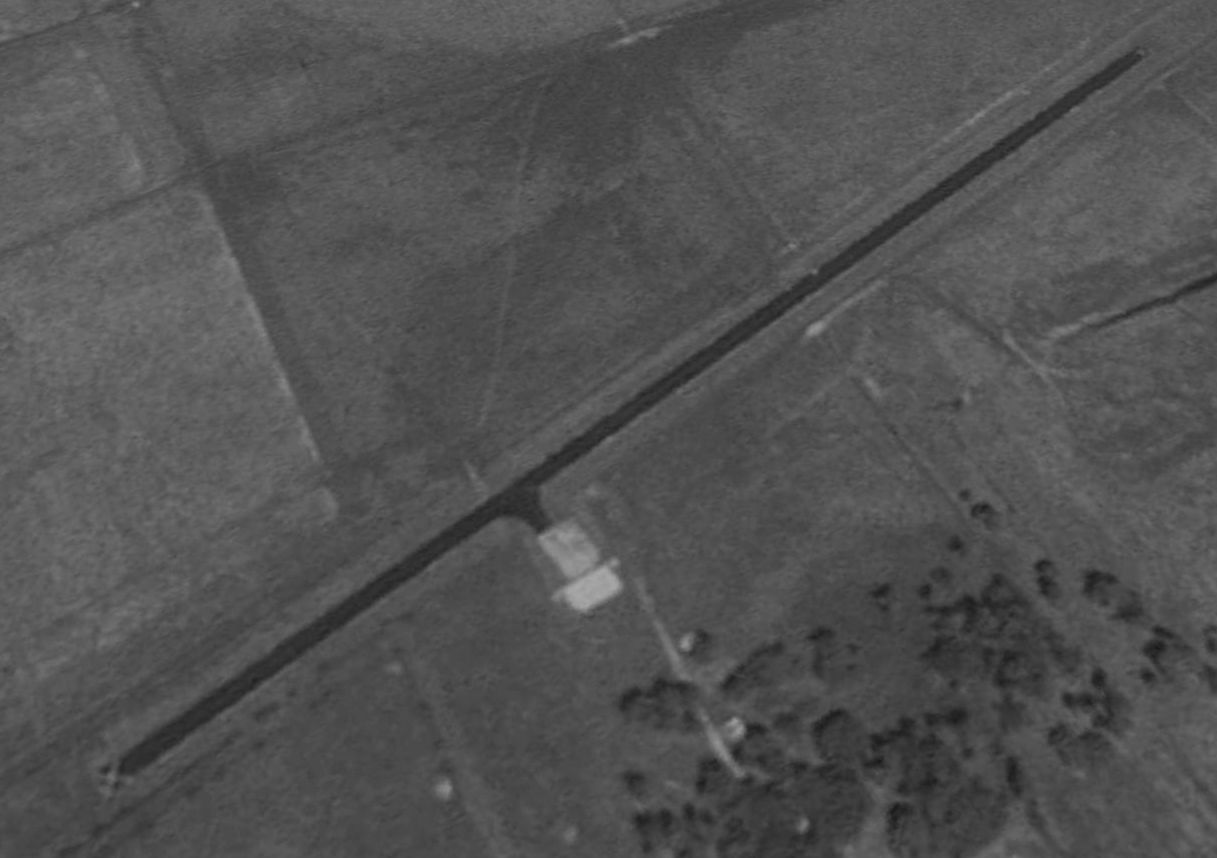
The earliest depiction of the field which has been located was on the September 1942 Miami Sectional Chart (courtesy of Chris Kennedy).
It depicted Immokalee as Site 13.
A 3/21/43 aerial view looking north at Immokalee Intermediate Field (from the National Archives, courtesy of Brina Rehwinkel)
depicted it as having 2 perpendicular grass runways, without any buildings or other improvements.
The 1945 AAF Airfield Directory (courtesy of Scott Murdock) described Immokalee Intermediate Field
as a 81 L-shaped property containing 2 sod runways, 3,770' northeast/southwest & 3,745' northwest/southeast.
No hangars were reported at the field,
which was described as being owned by private interests & operated by the Civil Aeronautics Administration.
The last aeronautical chart depiction which has been located of Immokalee Intermediate Field
was on the August 1947 Miami Sectional Chart (courtesy of Chris Kennedy).
It depicted the “Immokalee (CAA)” airfield as having a 3,800' unpaved runway.
Note that it also depicted the Immokalee AAF to the northwest, which had been constructed during WW2.
The Immokalee Intermediate Field was evidently abandoned at some point between 1947-54,
as it was no longer depicted at all on the August 1954 Miami Sectional Chart (according to Chris Kennedy).
The 1958 USGS topo map depicted a clearing in the shape of Immokalee Intermediate Field's 2 runways, but without any label.
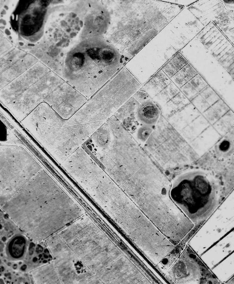
In the 1962 aerial photo (courtesy of Chris Kennedy), the former Immokalee Intermediate Field appeared abandoned,
but the airfield layout remained completely intact & very distinct.
The airfield had 1 unpaved runway running parallel to the road, northwest/southeast, and another oriented northeast/southwest.
There did not appear to be any buildings associated with the airfield.
Nothing at all was depicted at the site of Immokalee Intermediate Field on USGS topo maps from 1984, 1985, or 1988.
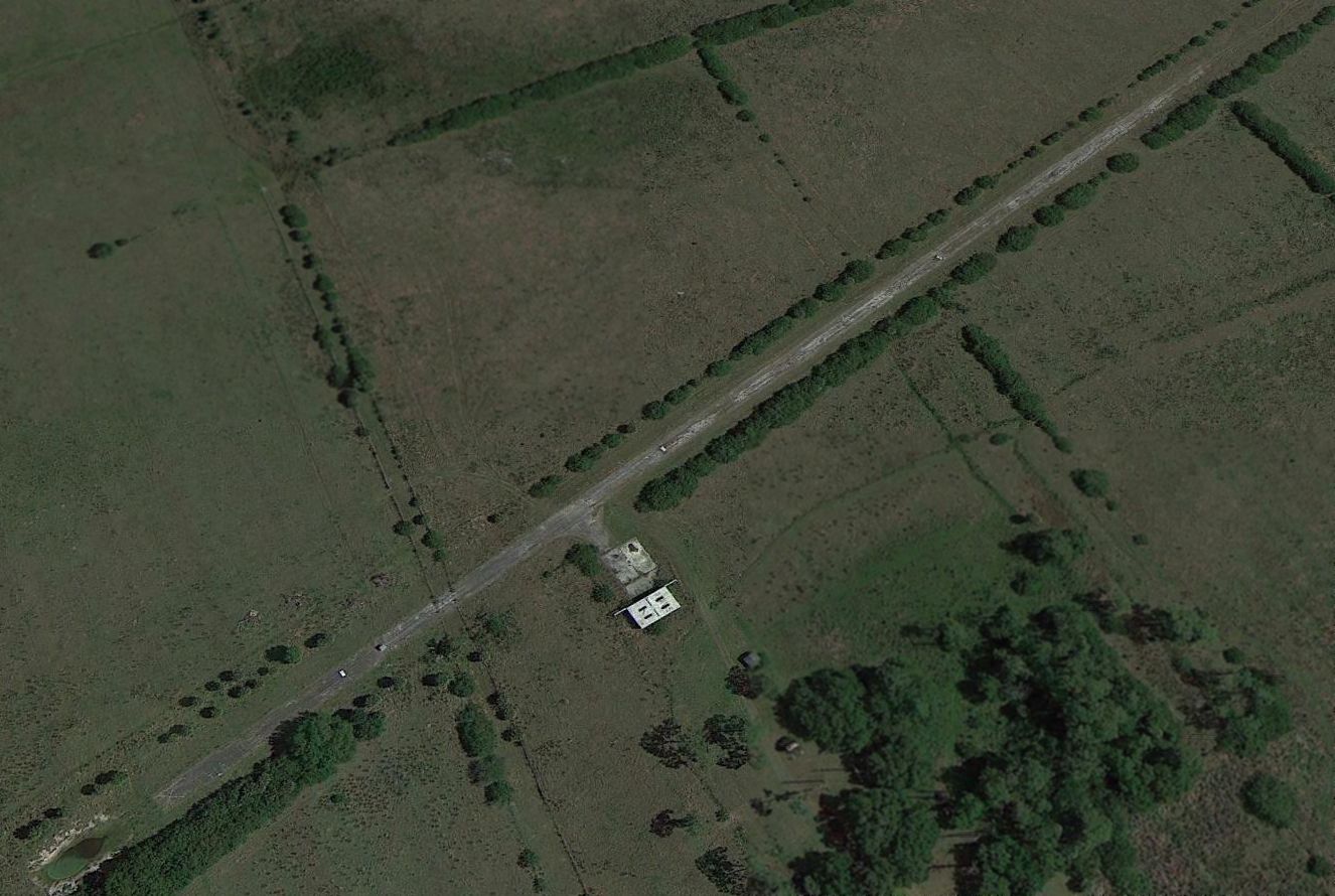
In a 1999 USGS aerial photo, the outline of the former Immokalee runways were no longer recognizable, with the site having been reused for agriculture.
No trace of Immokalee Intermediate Field was recognizable in a 2014 aerial photo.
A 2023 photo looking northeast showed no recognizable trace of Immokalee Intermediate Field.
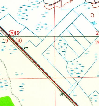
The site of the Immokalee Intermediate Field is on the northeast side of Route 29, 5 miles southeast of its intersection with Route 846.
____________________________________________________
Lehigh Acres Airpark (9X3), Lehigh Acres, FL
26.66, -81.61 (East of Fort Myers, FL)
Lehigh Acres Airpark was depicted on a 1953 aerial photo (from the U of FL Libraries)
as having a single unpaved northeast/southwest runway with a few small buildings on the northeast side.
This small private airfield was evidently built at some point between 1944-53, as it was not yet depicted on a 1944 aerial photo.
The earliest depiction of the field which has been located was a 1953 aerial photo (from the U of FL Libraries).
It depicted Lehigh Acres Airpark as having a single unpaved northeast/southwest runway with a few small buildings on the northeast side.
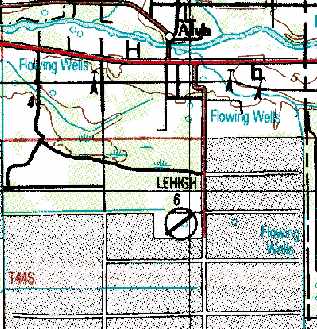
Lehigh Acres Airpark was not yet depicted on the 1956 FL Aeronautical Chart (courtesy of Roger Connor).
A 1958 aerial photo (from the U of FL Libraries) showed Lehigh Acres Airpark had gained a paved runway at some point between 1953-58.
Lehigh Acres Airpark was not yet depicted on the February 1961 Miami Sectional Chart.
The earliest aeronautical chart depiction which has been located of Lehigh Acres Airpark
was on the September 1964 Miami Sectional Chart (courtesy of Chris Kennedy).
The Aerodromes table described Lehigh Acres Airpark as a private field, having a single 3,134' asphalt runway.
The 1973 USGS topo map depicted a single runway, oriented northeast/southwest, labeled simply as "Landing Field".
Ed Drury recalled, “Lehigh Acres Airpark... My mother lived nearby & in the 1970s I landed there often.
It was owned by the Lehigh Corporation, the company who first built the development.
The Unicom was controlled by the corporation-owned motel a few miles away.
You would call them on Unicom & they would turn the lights on for you.
They warned you to buzz the runway before landing to get the deer or human 'lovers lane' people off of the runway.
Every time I landed at night the police would come looking for drug runners.
I think it was the twin-engined plane buzzing the field that alerted the police.
I buzzed the field & landed, as I tied the aircraft down, as usual a police car showed up.
They were very polite & asked if they could look in the airplane. The plane was still unlocked so I let them.
As they were looking, a dark sedan pulled up the perimeter road. Two guys in suits got out about 60' away.
The 2 cops got behind their car & challenged the men. In the end they all had guns out.
The 2nd car turned out to be U.S. Customs. After a few minutes it was all straightened out.
I remember standing behind the airplane & planning to jump I the canal with the gators if any shots came.
In the end I got the cops to drive me to my mother's house.”
"Lehigh" was depicted as a private airfield with a 3,200' paved runway
on the September 1980 Miami Sectional Chart (courtesy of Mitchell Hymowitz).
The 1982 AOPA Airport Directory (courtesy of Ed Drury) described the Lehigh Airport as having a single 3,225' asphalt Runway 5/23.
The remarks said, "Private. Use at own risk."
Ed Drury reported, “There was a hydroponic farm with an entrance tower & operations building that could appear to be an airport operations center.
There were no buildings at all on the field.”
"Lehigh" was still depicted as an active private airfield on the March 1987 Miami Sectional Chart (courtesy of Chris Kennedy).
It was still depicted as the "Lehigh" Airport on the 1988 USGS topo map,
but that doesn't necessarily indicate it was still an operating airfield at that point.
Lehigh Airport was apparently closed (for reasons unknown) at some point between 1987-98,
as it was no longer depicted at all on the 1998 World Aeronautical Chart.
A 1999 USGS aerial photo showed the outline of the former Lehigh Acres runway was still recognizable, although quite deteriorated.
Ted Porter reported in 2004, "It appears that they have been using the grounds for a borrow pit & dumping grounds."
A 2014 aerial photo showed the outline of Lehigh Acres former northeast/southwest runway was still barely recognizable, although heavily overgrown.
Vernon Conly reported that as of 2023, the site of Lehigh Airport is now a public park, Frank Mann Preserve.
The site of the Lehigh Airport is located west of the intersection of Joel Boulevard & East 18th Street.
____________________________________________________
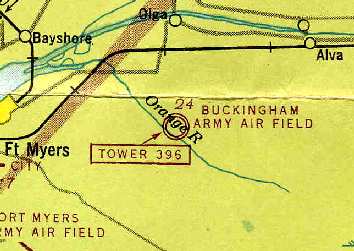
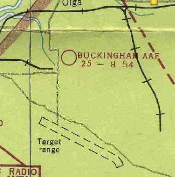
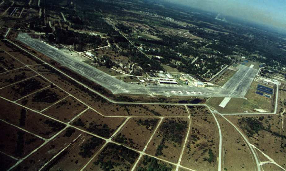
Buckingham Army Airfield / Lehigh West Airfield / Buckingham Field (FL59),
Buckingham, FL
26.64, -81.71 (East of Fort Myers, FL)
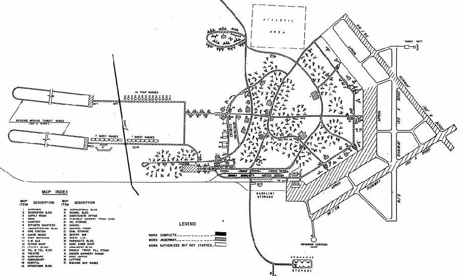
A July 1942 Army Corps of Engineers “Field Progress Report” of the “Buckingham Flexible Gunnery School” (courtesy of Michele McNeill).
Buckingham was a flexible gunnery training base, used to train the gunners who would defend bombers.
It was constructed starting in 1942 at a cost of $10 million on a total of 7,000 acres of swamp land,
which had to be drained with an extensive system of newly constructed canals.
The earliest depiction which has been located of the Buckingham airfield
was on a July 1942 Army Corps of Engineers “Field Progress Report”
of the “Buckingham Flexible Gunnery School” (courtesy of Michele McNeill).
It depicted the airfield as having three 5,000' runways,
of which the northeast/southwest & northwest/southeast strips were under construction
and the north/south runway was “authorized but not yet started”.
Of the massive ramp area, the southern 2/3rds was under construction,
with the northern third also being “authorized but not yet started”.
It also depicted the 2 oval tracks of the “Ground Moving Target Range”, located to the west of the airfield,
as well as nearby skeet ranges & trap ranges.
Training was conducted in both air-to-air & air-to-surface gunnery.
The air-to-air training used a variety of aircraft, including T-6, RP-63, B-17, and B-24s.
For ground-based training, a number of facilities were available,
including the moving target ranges & a number of gunnery simulators.
![]()
A WW2 emblem for the Buckingham Flexible Gunnery School (courtesy of Johnny Signor).
According to Joe Benson, "Most of the B-24's that flew the oil refinery raids over Ploesti, Romania came from Buckingham.
When the mission idea came down, they took most of the crews from Buckingham as they were experienced.
They were in the middle of their frangible bullet training there.
That was where they had a P-39 & a couple of other aircraft with an extra layer of skin
and they fired the bullets right at the aircraft instead of a tow target."
The earliest aeronautical chart depiction which has been located of Buckingham AAF
was on the 1943 Miami Sectional Chart (courtesy of Chris Kennedy).

The cover of a June 1943 Buckingham Army Air Field class book (courtesy of Butch Moran, who reported “My uncle Herbert Bisulk was stationed at Buckingham Field.”)
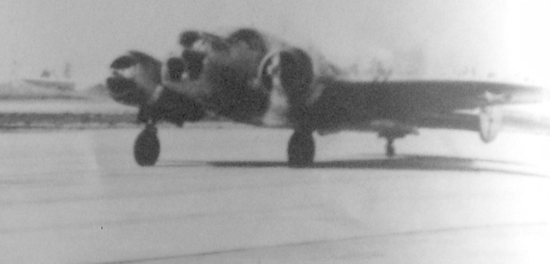
An undated photo of a Beech AT-11 Kansan taxiing on the Buckingham ramp from a June 1943 Buckingham Army Air Field class book (courtesy of Butch Moran).
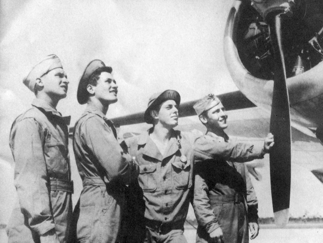
An undated photo of unidentified students examining an aircraft at Buckingham Field, from a June 1943 Buckingham Army Air Field class book (courtesy of Butch Moran).
Buckingham AAF was described by the 1944 US Army/Navy Directory of Airfields (courtesy of Ken Mercer)
as having a 5,000' hard-surface runway.
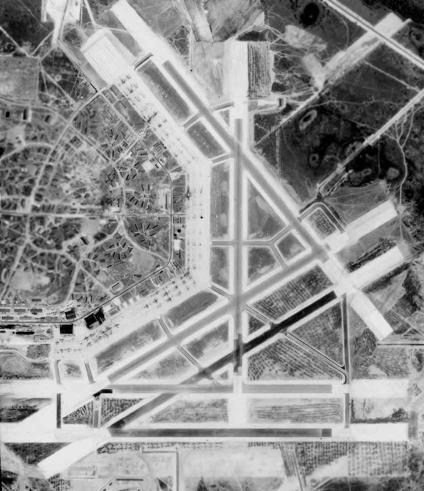
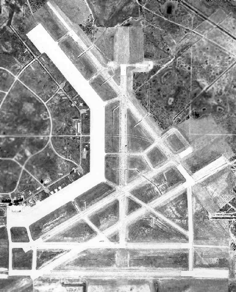
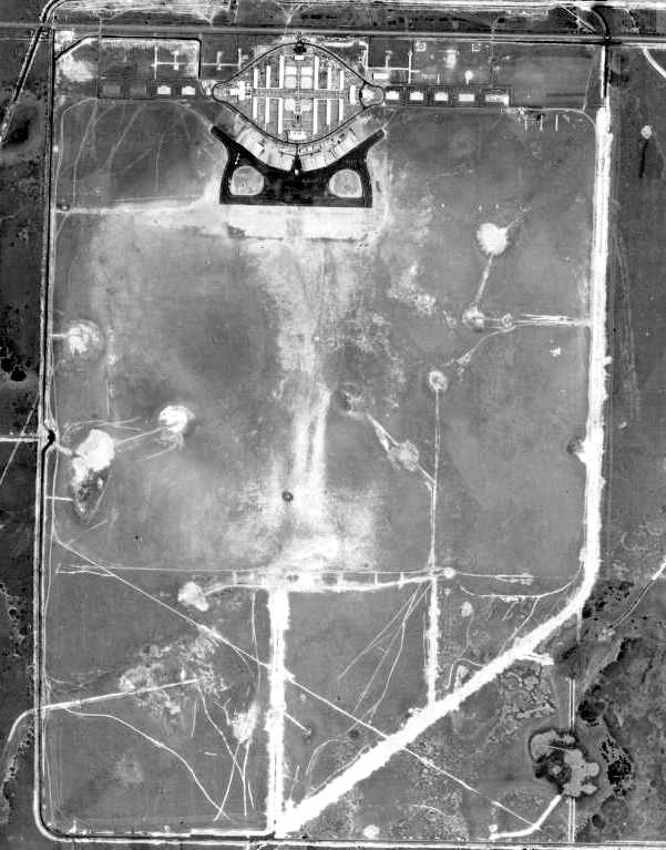
A 4/14/44 US Government aerial photo (courtesy of the FL DOT, via Brian Rehwinkel) of Buckingham AAF,
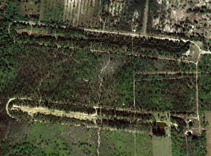
showing how massive the field was in its peak wartime configuration - with a total of 6 large paved runways.
Note the hundreds of buildings in the area to the west of the airfield.
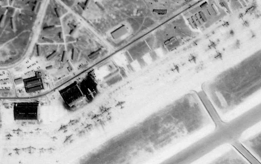
A close-up of B-17 bombers on Buckingham's ramp,
from the 4/14/44 US Government aerial photo (courtesy of the FL DOT, via Brian Rehwinkel).
A 1945 aerial view looking west at Buckingham AAF,
in the field's peak wartime configuration, with 6 runways.
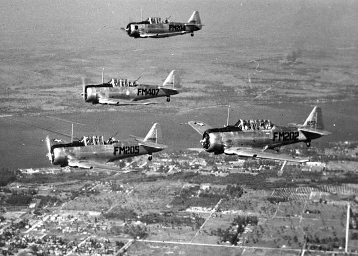
A circa 1945 aerial view of 4 AT-6 Texans flying over the Caloosahatchee River
en route to the Buckingham Flexible Gunnery School's range over the Gulf of Mexico
(courtesy of the Special Collections Department, University of South Florida, via Don Stice).
Three of the AT-6s are carrying flexible-mount machine guns, and the 4th is carrying the tow target.
At its peak Bcukingham housed 16,000 men.
By the end of WW2, the airfield consisted of a total of 6 concrete runways (the largest was 5,800' long), along with a large concrete ramp area.
According to the book "Forgotten Fields of America, Volume III" by Lou Thole,
during WW2 Buckingham Field & its target ranges were comprised of a total of 65,723 acres, and had approximately 700 buildings.
The 1945 AAF Airfield Directory (courtesy of Scott Murdock) described Buckingham AAF
as a 4,420 acre rectangular property containing 4 asphalt 5,000' runways.
The field was said to have 2 hangars (the largest being a 200' x 120' steel structure),
to be owned by the U.S. Government, and operated by the Army Air Forces.
Buckingham closed in 1945, after graduating almost 48,000 aerial gunners.
However, Buckingham AAF was still depicted as an active military airfield on the August 1947 Miami Sectional Chart (courtesy of Chris Kennedy).
The runways were still depicted as being 5,400' long. Note the large target range also depicted south of the airfield.
After the war, the barracks at Buckingham were briefly used as the Edison College, but this closed in 1948.
Most of the buildings of the original base were subsequently removed over time.
A 1/26/53 US Government aerial photo (courtesy of the FL DOT, via Brian Rehwinkel) of the former Buckingham AAF.
In this picture, the pavement of all of the runways (approximately 6 miles of runways) & most of the taxiways had already been removed,
along with hundreds of buildings (including all of the hangars).
The concrete ramp, and a few other concrete foundations seem to be the only thing remaining.
In the words of Brian Rehwinkel, "I don't know how much this base cost to build,
but less than 10 years after it was opened - it was flattened. It borders on the bizarre!"
Buckingham Field was no longer depicted on the 1956 FL Aeronautical Chart (courtesy of Roger Connor).
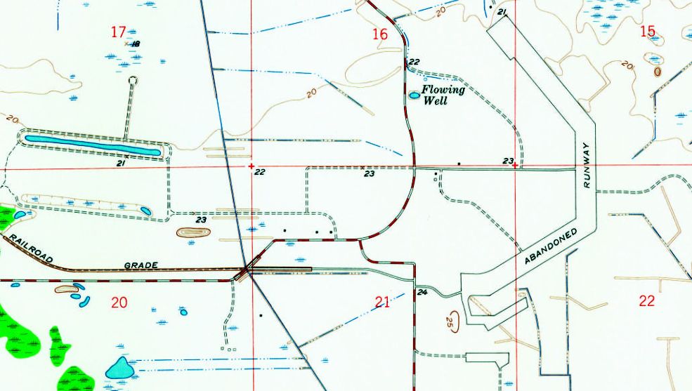
Ironically the 1958 USGS topo map depicted Buckingham AAF's former ramp as an “Abandoned runway”,
but no longer depicted the runways themselves (other than a small portion of the northeast/southwest runway).
Also note the 2 oval tracks of Buckingham's Ground Moving Target Range were still depicted to the west of the airfield.
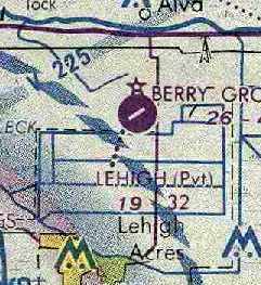
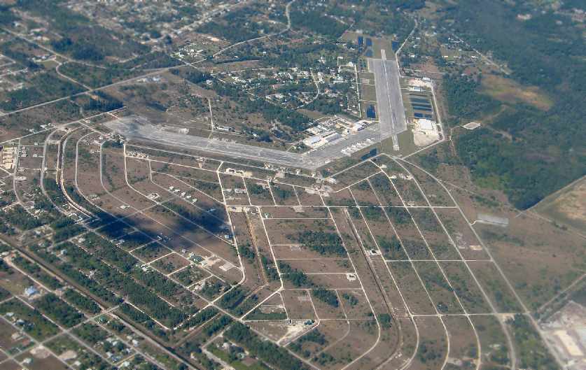
By the time of the September 1964 Miami Sectional Chart (courtesy of Chris Kennedy),
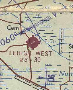
the only 'runway' still depicted at what was then known as "Lehigh West" Airport
was a single 3,000' paved portion of the former AAF ramp.
The remarks in the Aerodromes table said "Runways 14/32 & 18/36 closed."
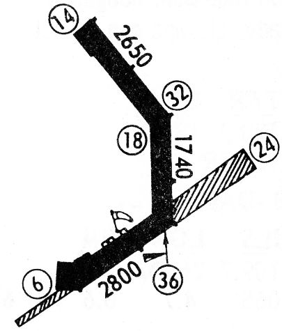
The 1968 Flight Guide (courtesy of Robert Levittan) depicted "Lehigh Acres West" Airport
as having 3 paved runways laid out on portions of the former Buckingham AAF ramp.
A street grid for a planned housing development named Lehigh Acres
was eventually built over the area formerly occupied by Buckingham's runways.
Joe Benson recalled, "In 1976, the runways were gone except for the concrete ends.
Buckingham was one of the few bigger fields that had a pool!
I was over there stomping around in 1976 & it was still there."
The 1978 Miami Sectional Chart (courtesy of Ed Drury) depicted 3 paved portions of Buckingham's former ramp
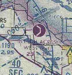
as the runways of the "Lehigh Acres West" private airfield.
The longest runway was depicted as 3,000'.
The March 1987 Miami Sectional Chart (courtesy of Chris Kennedy) depicted the "Lehigh Acres West" Airport
as a private field having 3 paved runways, comprised of portions of the former AAF ramp.
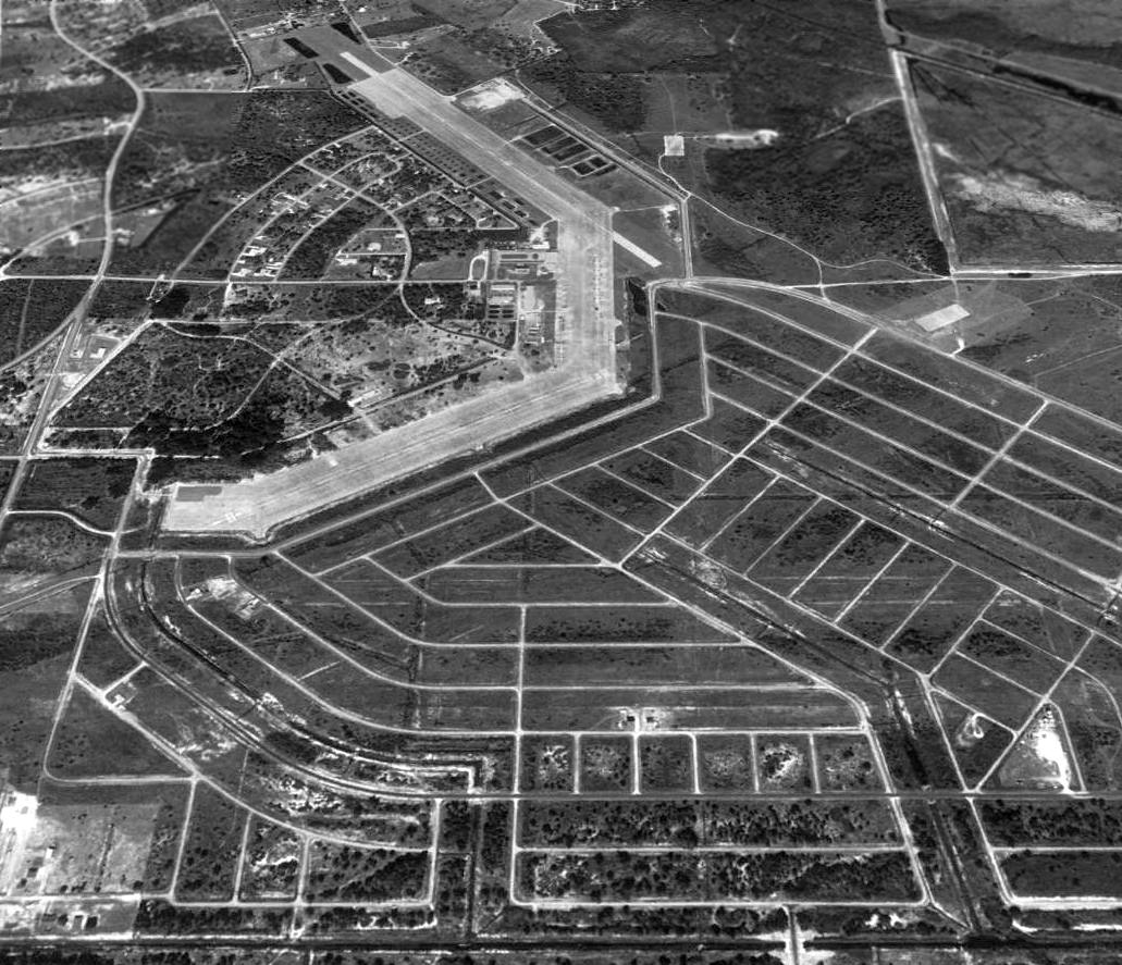
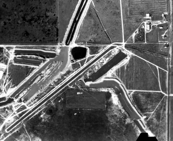
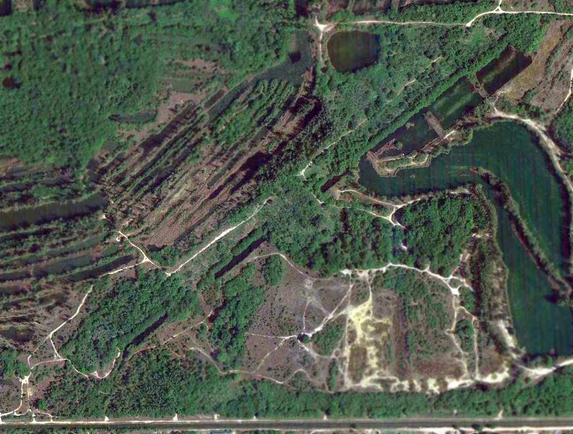
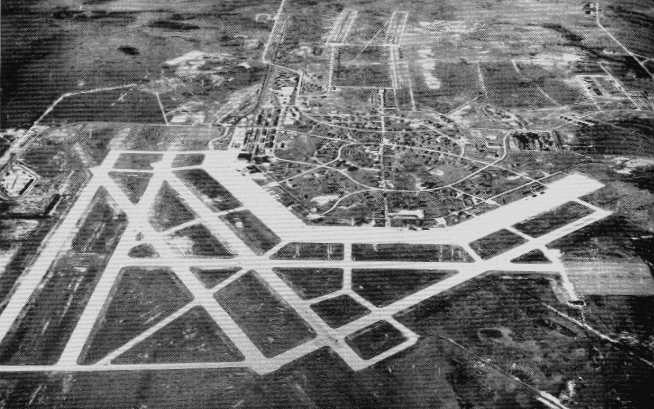
A 1994 USGS aerial view looking north at the remains of Buckingham AAF,
in which street grids had replaced the multiple runways, leaving the former ramp as the sole remaining airfield surface.
A 1996 aerial view by Lou Thole (author of the book "Forgotten Fields of America")
of the ramp areas of the former Buckingham AAF (note the C-47s parked on the ramp).

A 1996 photo by Lou Thole of the overgrown remains
of the foundation of a WW2-era Waller Trainer building at Buckingham.
The street grid built over the location of the former runways remained undeveloped for some period of time,
before eventually being partially filled in with houses.
As of 2000, the northern portion of the ramp continues to be used as a runway.
It is operated as a private field, Buckingham Field Airport,
by the Lee County Mosquito/Hyacinth Control District,
which operates a fleet of 23 aircraft & helicopters (including C-47s & several rare C-117 Super Dakotas).
Portions of the ramp area are also used for automobile racing.
Chris Hulen (Continental Express EMB-145 pilot) overflew the former Buckingham AAF in 2003.
"The field (or what is left of the ramp area) is used by DC-3s for mosquito patrol.
There must have been over a dozen of them parked.
The runways are 14/32 & 6/24, and are on the north & south ends of the former ramp, respectively.
There was not any activity on the Sunday evening that I flew over, but the runways showed signs of use."
A 2004 photo by Steve Dodson looking northwest at Buckingham Field,
showing the area formerly occupied by the original runways in the foreground.
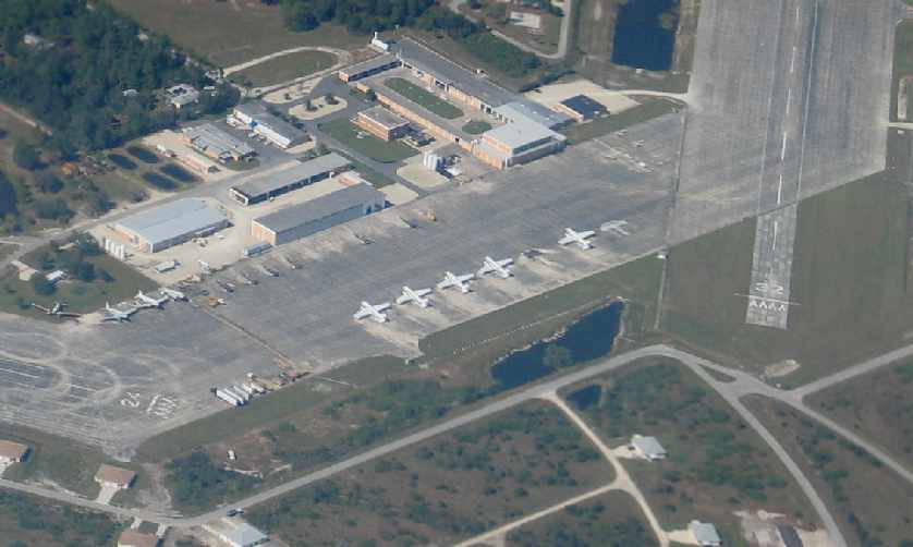
A 2004 close-up photo by Steve Dodson looking northwest at the C-47s on the ramp of Buckingham Field.
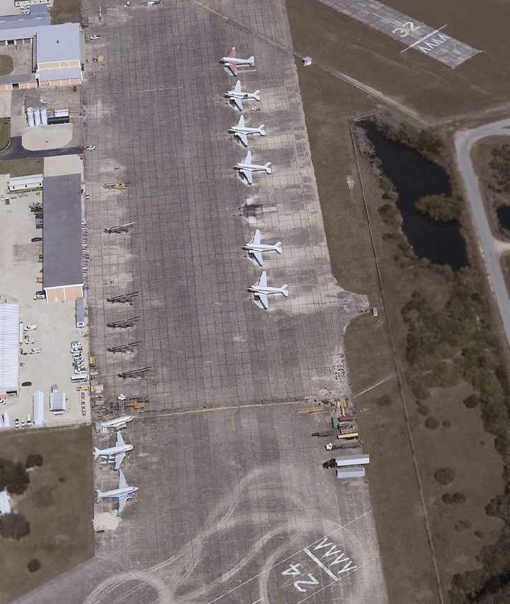
A circa 2000-2005 aerial view looking north along the ramp at Buckingham, showing numerous C-47s & UH-1s.

A 2/14/05 photo of 6 C-47s/DC-3s on the Buckingham ramp.
A circa 2005 aerial view of the remains of the 2 oval tracks of the Ground Moving Target Range, located to the west of the airfield.
Nick Swords reported in 2006 that the southern portion of the former Buckingham AAF
“is now a pilot community with homes & hangars. Funniest thing I ever saw.
Walking down the street & to see a plane make a right turn at a stop sign,
hit the garage door opener (hangar), pull in & close the door. Just as if they had pulled up in their car.”
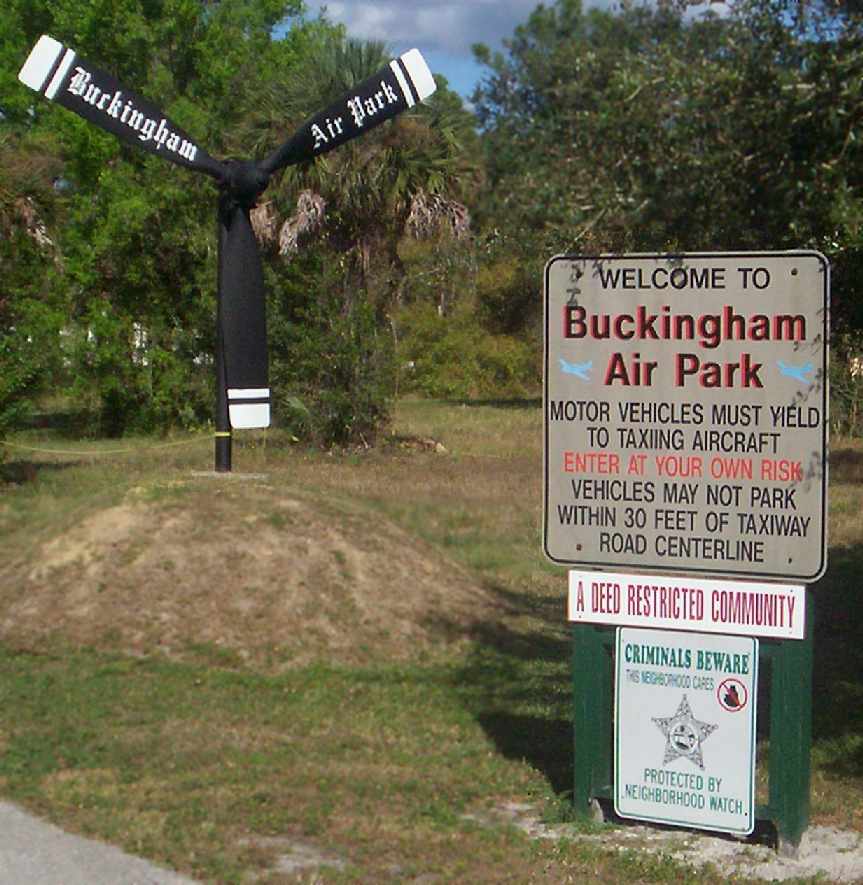
A 2007 photo by Scott Shea of the propeller mounted as a display behind the entrance to Buckingham Air Park.
Scott Shea reported in 2007, “The airport is now called FL59 - Buckingham Field Airport.
My father lives on what used to be an East/West runway (Daniels Lane).
He drove me around the former AAF. Much to my surprise, they have saved the airport & turned it into a beautiful airpark!
There are many aircraft that now call Lehigh Acres its home!
There is a beautifully restored Stearman, many Homebuilts such as RV-6 & RV-7s,
as well as many Cessna & Piper aircraft; a PT-19 is also housed there!
Lee County Mosquito Control still has numerous H-1 Hueys & DC-3s which unfortunately I did not get to see operate.
Lee County Mosquito Control also has an full-size old Bell 47 as a weather vane
which I have not seen in aerial photographs.
The Airpark uses Runway 14/32 (4,046') , however, Runway 6/24 (2,726') is still used & active.
I was not witness to any activity on Runway 6/24 other than automobile races which happen every Saturday, however Runway 14/32 was very active!
My father saw one of the DC-3s buzz Runway 6,
as well as a Huey fly an approach down Runway 6 while I was out doing touristy things for the day,
however Runway 6/24 is very much still used & active!
I watched an auto race on Runway 6/24; the end of the Runway 6 is a stone's throw away from my dad's house.
I also witnessed numerous foundations in the vicinity of the area, some of which are a over a ½ mile from the base.
There is still a 200' x 50' slab of concrete just to the south of Runway 14/32
which was part of one of the former East/West runway which saw some flying action while I was down there!
My father, an avid model airplane builder, flies his radio controlled Slow Stick down there -
minding that it was only a few hundred feet from the approach end of Runway 32!
There are a few modelers who use that slab along with my father to fly model airplanes!
Another thrill was fishing in a pond that overlooked the beautiful DC-3s directly in front of this pond.
The only unpleasant sight/thought, there are 2 known alligators inhabiting this fishing pond!
My attention was more on the surface of the water than the DC-3s!”
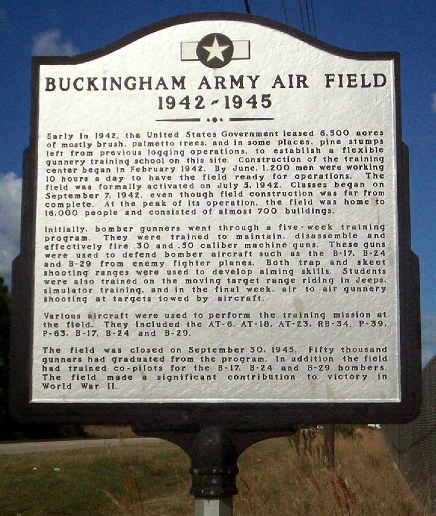
A 2007 photo by Scott Shea of the historical marker commemorating the former Buckingham Army Air Field.
A 2014 aerial view looking north at the remains of Buckingham AAF,
now a considerably shrunken air facility, in which the former ramp now serves as a runway.
Two C-47s of the Lee County Mosquito/Hyacinth Control District are visible on the ramp at the bottom-left.
See also:
"Forgotten Fields of America", Volume II, Lou Thole, p.41.
http://www.swfia.com/aboutairport/history/gunnery.html
http://gulfcoastautocrossers.com/history.html
____________________________________________________
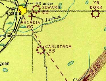
27.13, -81.805 (Northeast of Fort Myers, FL)
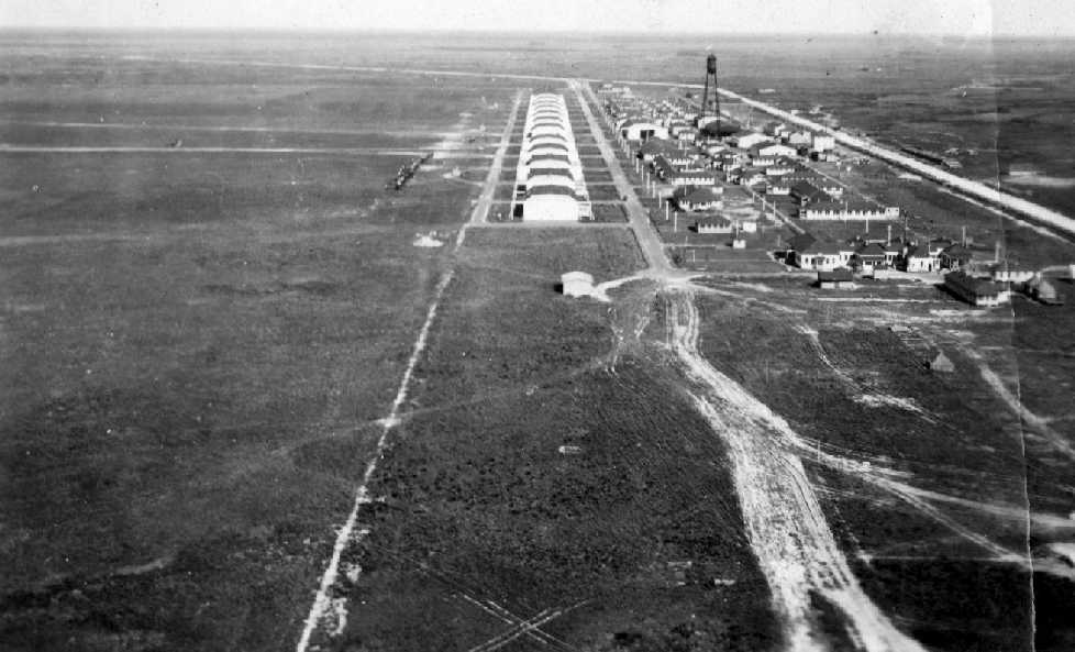
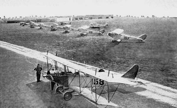
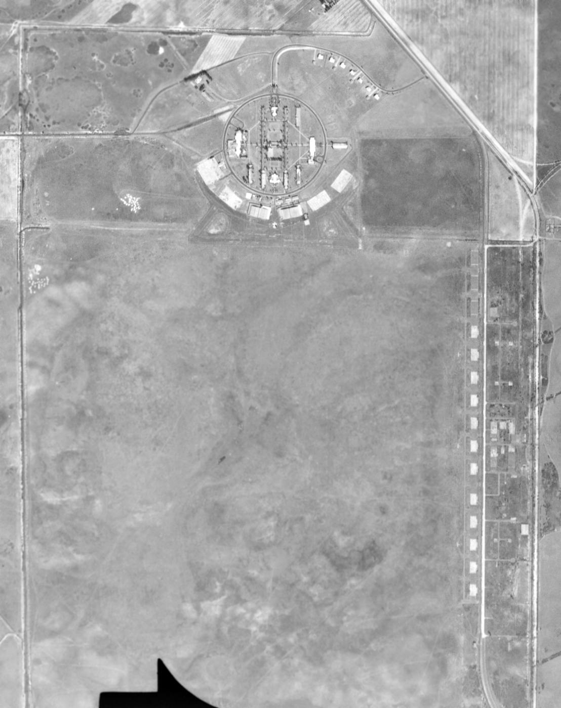
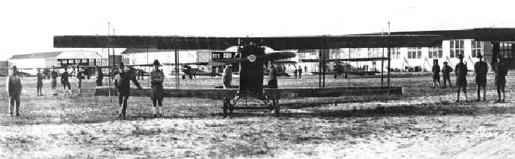
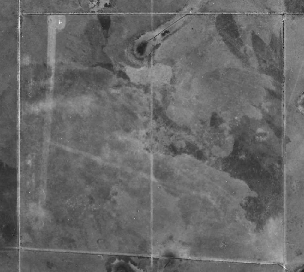
A circa 1917-22 aerial view looking north from an airship at Carlstrom Field (from the photo album of Sgt. Ralph Anderson, courtesy of Jeff Ross),
showing a long row of hangars on the east side of a grass airfield.
Carlstrom Field was established in 1917 to train military pilots for WW1 (according to a 1997 Army Corps of Engineers report).
The airfield facilities consisted of a total of 90 buildings & structures, Including a row of hangars located along a square mile grass field.
This site consisted of a total of 696 acres.
Carlstrom Field was named after pioneering aviator Victor Carlstrom, who was killed in an aircraft accident in Newport News, Virginia in 1917.
An undated aerial view of Calrstrom Field from the booklet “Christmas at Carlstrom Field 1918” (courtesy of Verne Deubler, whose father served at Carlstrom Field during WW1).
The photo depicted a long row of 15 hangars oriented north/south, with additional buildings to the east.
A WW1 era photo of 1st Lt. Harry Haw in front of a Thomas-Morse S-4 Scout single-seat biplane trainer at Carlstrom Field.
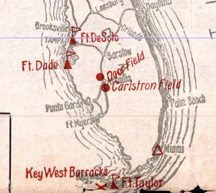
Flying operations at Carlstrom Field were supported by a satellite airfield, Dorr Field, during WW1.
The earliest map depiction which has been located of Carlstrom Field was on the 1919 TIB Military Map of the US (courtesy of Jonathan Westerling).
Note that it misspelled the airfield's name “Carlstron”.
In October of 1919, final testing of an experimental unmanned aircraft (a primitive guided missile)
called the "Kettering Bug" was successfully tested & launched at Carlstrom Field.
An undated photo of biplanes at Carlstrom field.
Carlstrom Field was placed in an inactive status in 1922,
and all of the buildings were sold to private individuals & removed by 1926.
No airfield at all was depicted at the site of Carlstrom Field on the December 1935 Miami Sectional Chart (courtesy of Chris Kennedy)
or the the July 1940 Miami Sectional Chart.
With the onset of WW2, the Carlstrom Field location was chosen to be the site
for a contract flying training school to be run by the Embry Riddle Academy.
A new facility was built adjacent to the remains of the WW1-era facilities.
A postmark commemorated the 4/5/41 Re-dedication of Carlstrom Field.
A photo of the 1941 recommissioning of Carlstrom Field (courtesy of Tim Kirby of www.coconutflyers.com).
John Paul Riddle is the man in the cowboy hat in the center.
The earliest government aeronautical chart depiction which has been located of Carlstrom Field
was on the May 1941 Miami Sectional Chart (courtesy of Chris Kennedy).
It depicted Carlstrom as a
commercial airfield, but with the comment, “Restricted to Air
Corps training.”

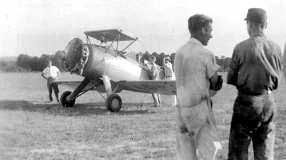
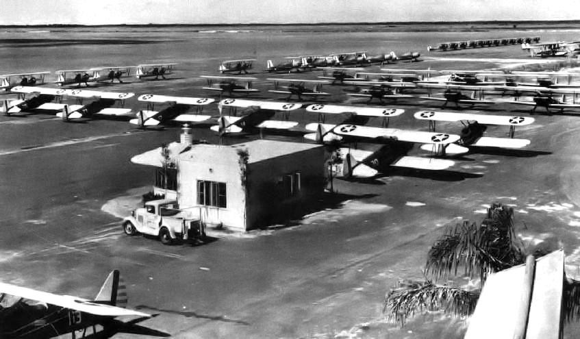
A 1941 aerial view looking north at Carlstrom Field showing a row of Stearman trainers in front of the hangars.
A circa 1941 aerial view looking north at Carlstrom Field (courtesy of David Brooks).
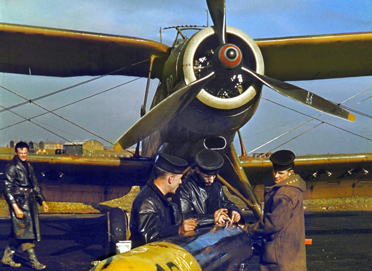
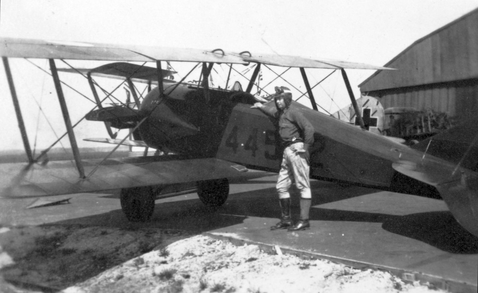
A 1941 photo of Royal Air Force cadets loading a torpedo onto an Albacore during training at Carlstrom Field.
Mark Ball recalled, "I was a flight instructor from October 1941 to October 1943 at Carlstrom Field."
He reported that Carlstrom trained British pilots, while nearby Dorr Field trained American pilots.
Mark also recalled that during the 2 years he was at Carlstrom, the field operated without any fatalities.
A 1942 photo of a Major George Ola in a Stearman biplane trainer over Carlstrom Field (courtesy of David Brooks).
A 1943 aerial view looking south at Carlstrom Field.
The multiple squares along the road in the upper left are the foundations
of the First World War hangars of the original Carlstrom Field.
A 1943 closeup of Carlstrom Field hangars.

A close-up of Carlstrom's hangars & ramp, from a 1943 USDA aerial photo of Dorr Field,
from the Digital Library Center / University of Florida George A. Smathers Libraries (courtesy of Brian Rehwinkel).
Note the large number of planes on the ramp.
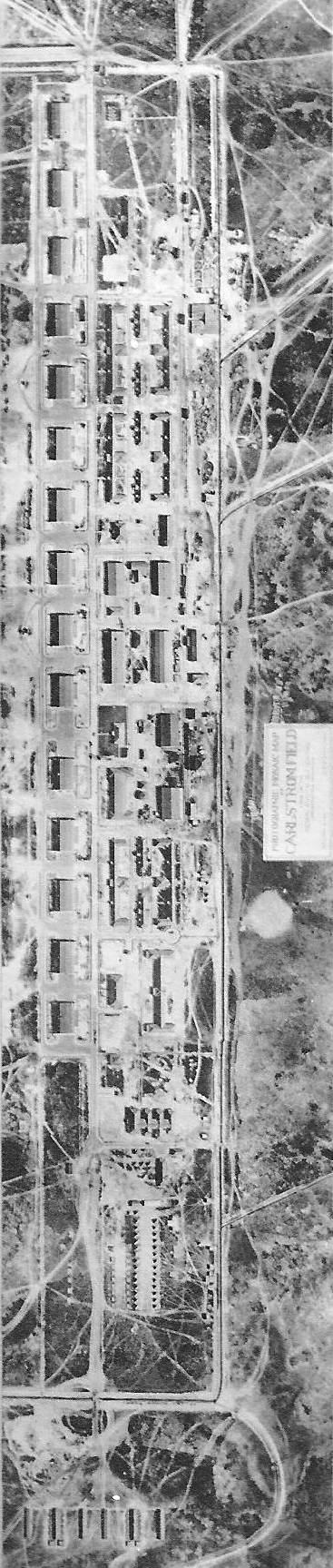
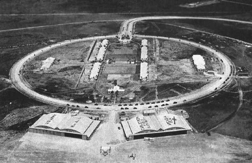
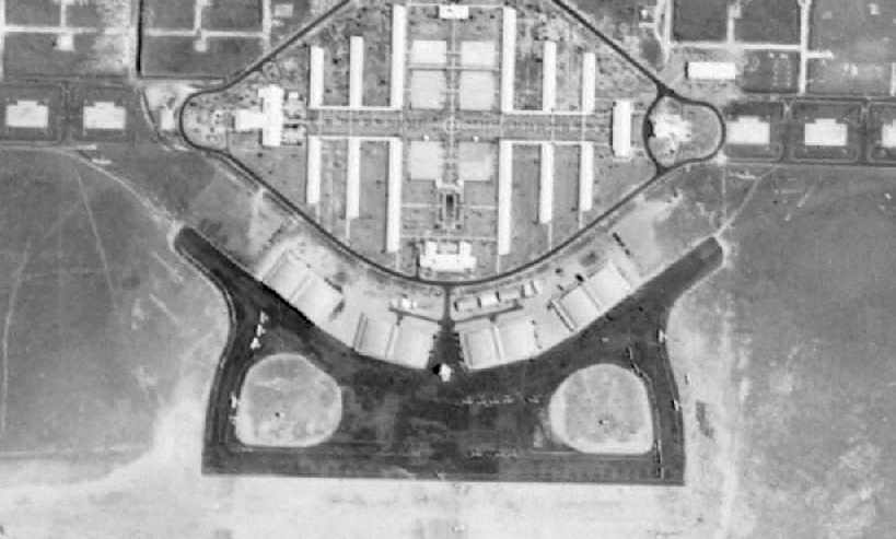
Carlstrom Field had a very unusual layout, with a compact group of buildings located inside a circular road,
with five hangars located around the southern periphery of the road.
No paved runway was ever built - the flying continued to be conducted from the 1 square mile grass field.
Carlstrom Field & a few of its satellite fields, as depicted on the 1943 Miami Sectional Chart (courtesy of Chris Kennedy).
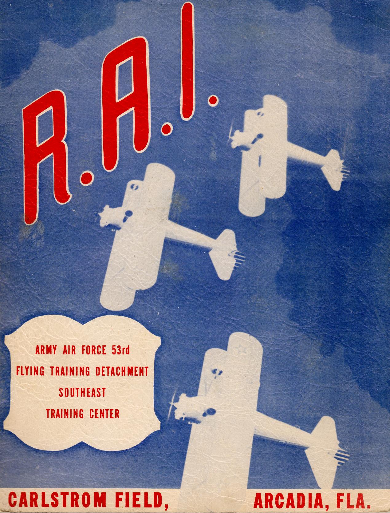
The cover of a 1943 magazine describing the Army Air Force 53rd Flying Training Detachment Southeast Training Center at Carlstrom Field (courtesy of Lisa Stanford).
A circa 1940s photo of a biplane “ground trainer” at Carlstrom Field.
This was an aircraft on which he majority of the upper wing had been removed, so as to prevent it from generating enough lift to become airborne,
to intentionally limit it to ground taxi & runway training.
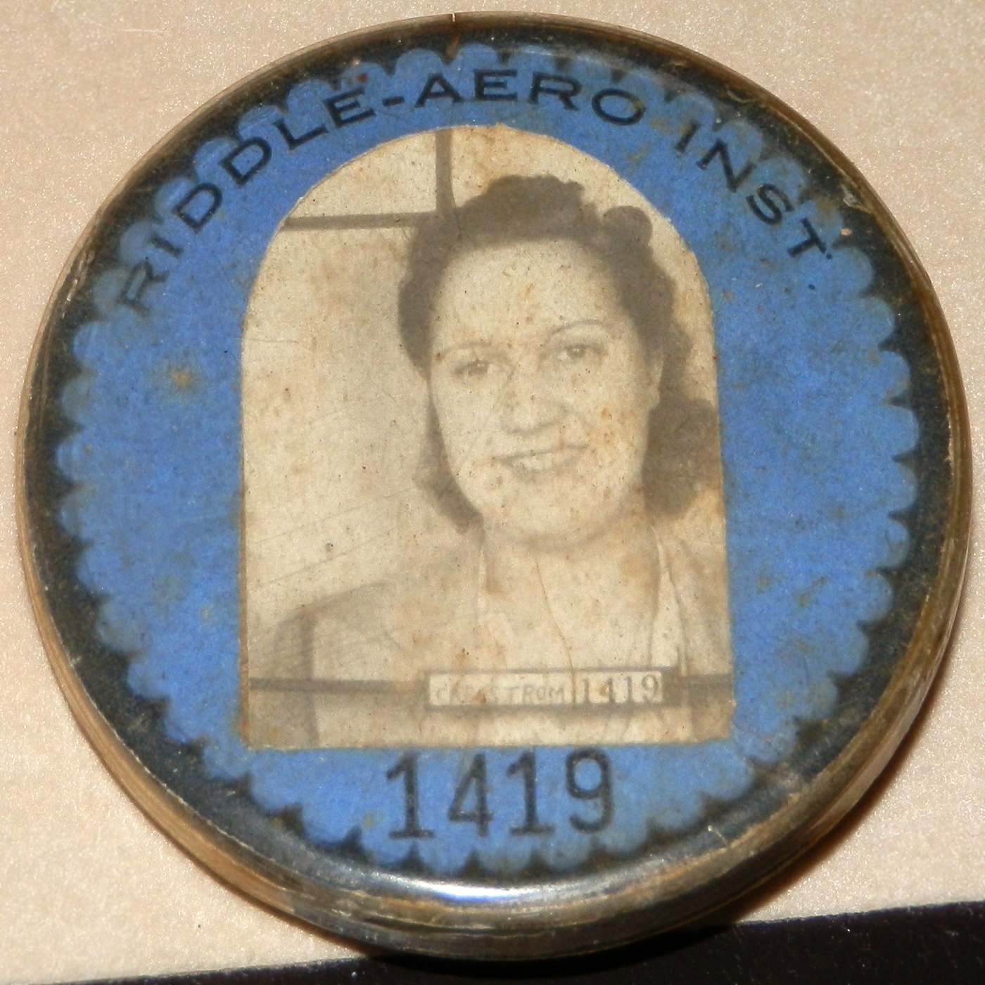
A 2015 photo by Lou Tyson Snyder of her mother, Rosa Mae Sullivan's Riddle Aeronautical Institute 1940s employee badge from Carlstrom Field.
Lou recalled, “Rosa Mae [was a] civilian clerk typist in the Administration Building from 6/12/42 until facility closing.
Her Mother was also employed at Carlstrom as an Entry Gate Guard.
Rosa Mae later married John Tyson, also employed at Carlstrom as an Mechanic/Aviation Metalsmith before he joined the Navy in 1942.
Rosa Mae's Mother & son were employed there as were several other family members.”
Two 1944 photos by John Stanford of biplane trainers at Carlstrom Field (courtesy of Lisa Stanford).
According to Lisa Stanford, “My father [John Stanford] trained for WWII at Carlstrom Field.
He was born in 1924 so he was quite young at the time he was taking flight training.”
Carlstrom Field & its satellite fields, as depicted on the August 1945 Miami Sectional Chart.
Many flight cadets from Great Britain were trained at Carlstrom Field during WW2.
A total of 23 of these British pilots died while at Carlstrom,
and the city of Arcadia dedicated a special area in the city cemetery (Oak Ridge Cemetery) in their honor, where they were laid to rest.
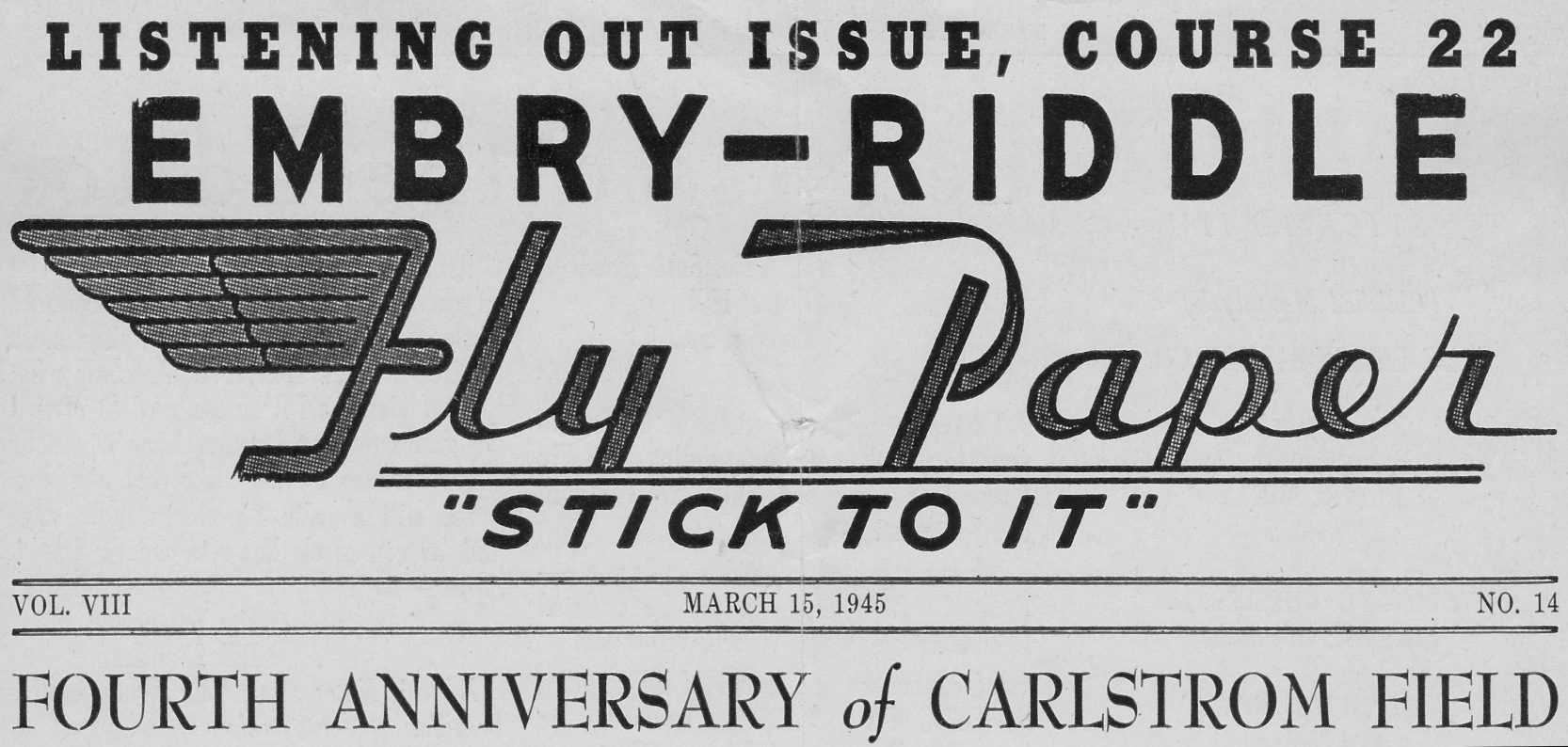
The headline of the 3/15/45 Embry-Riddle “Fly Paper”, commemorating the 4th anniversary of Carlstrom Field (courtesy of Lisa Stanford).
Lisa Stanford reported, “My father was John Stanford; he trained [at Carlstrom] in the 1940s & went on to become a B-24 pilot toward the end of WW2.”
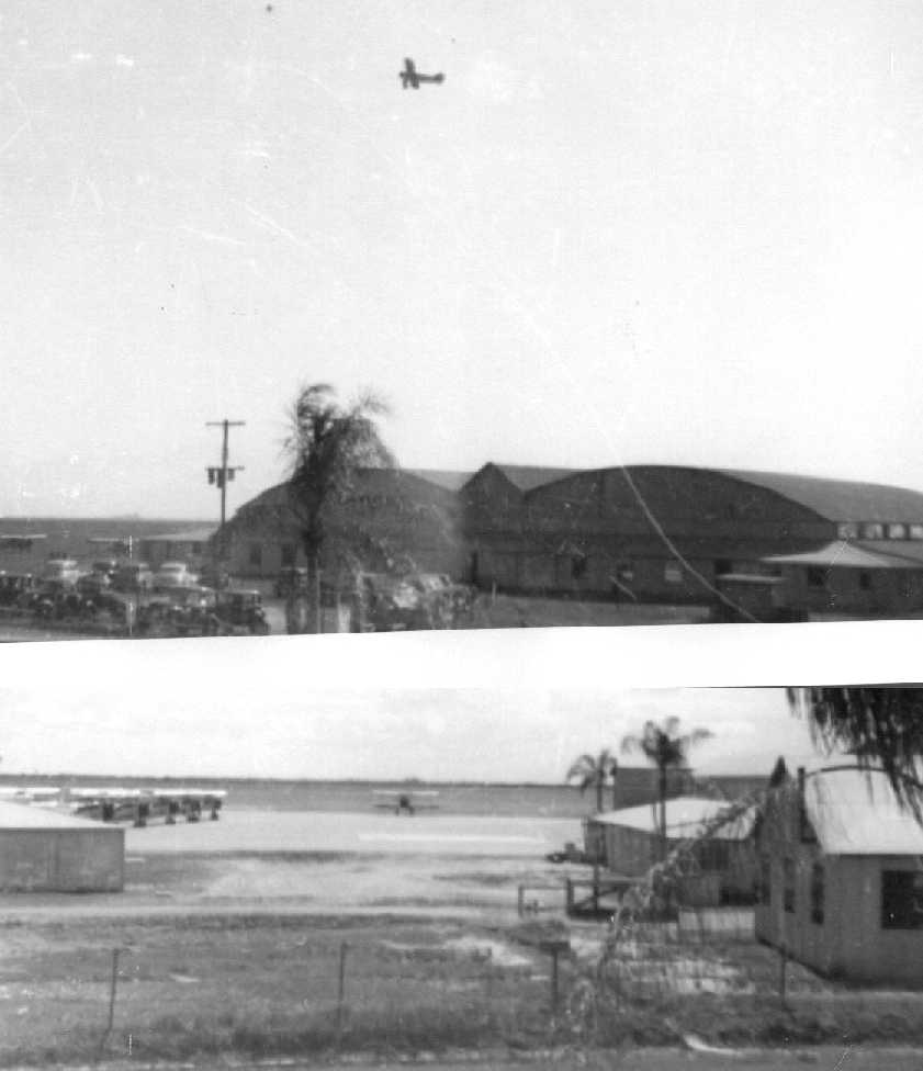
An undated aerial view looking south at Carlstrom Field from the cover of the 3/15/45 Embry-Riddle “Fly Paper” (courtesy of Lisa Stanford),
showing the 6 hangars & a large number of biplane trainers on the north side of the grass airfield.
An undated photo of a Link Trainer (an early flight simulator) being used for flight instruction at Carlstrom Field from the 3/15/45 Embry-Riddle “Fly Paper” (courtesy of Lisa Stanford).
An undated photo of Carlstrom Field's control tower & several biplanes from the 3/15/45 Embry-Riddle “Fly Paper” (courtesy of Lisa Stanford).
Carlstrom's entry in a 1945 Army airfield directory (courtesy of Bob Widner).
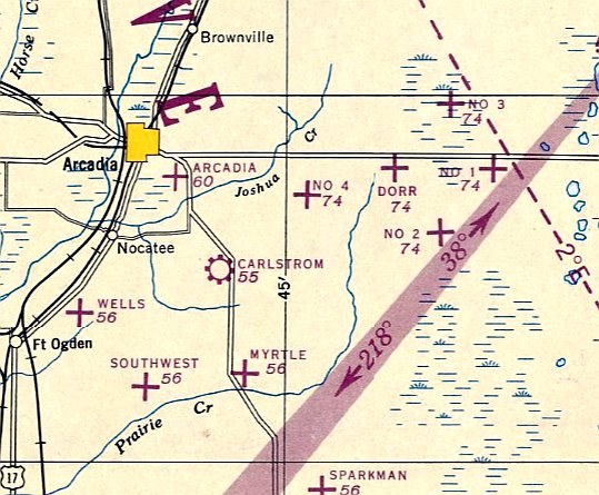
It also listed the auxiliary fields which supported flight training at Carlstrom Field:
Carlstrom Auxiliary #2 (Welles Field), Carlstrom Auxiliary #3 (Myrtle Field), Carlstrom Auxiliary #4 (Southwest Field),
and Calstrom Auxiliary #5 (Sparkman Field) (11.5 miles SSE).
Carlstrom Field turned out the last of its cadets in 1945, and closed later that year.
The last aeronautical chart depiction which has been located of Carlstrom Field was on the February 1947 Miami Sectional Chart.
It depicted Carlstrom as having a 5,300' unpaved runway.
Carlstrom Field was no longer depicted on the August 1947 Miami Sectional Chart.
Both Carlstrom & Dorr Fields were sold to the State of Florida for a total of $1.
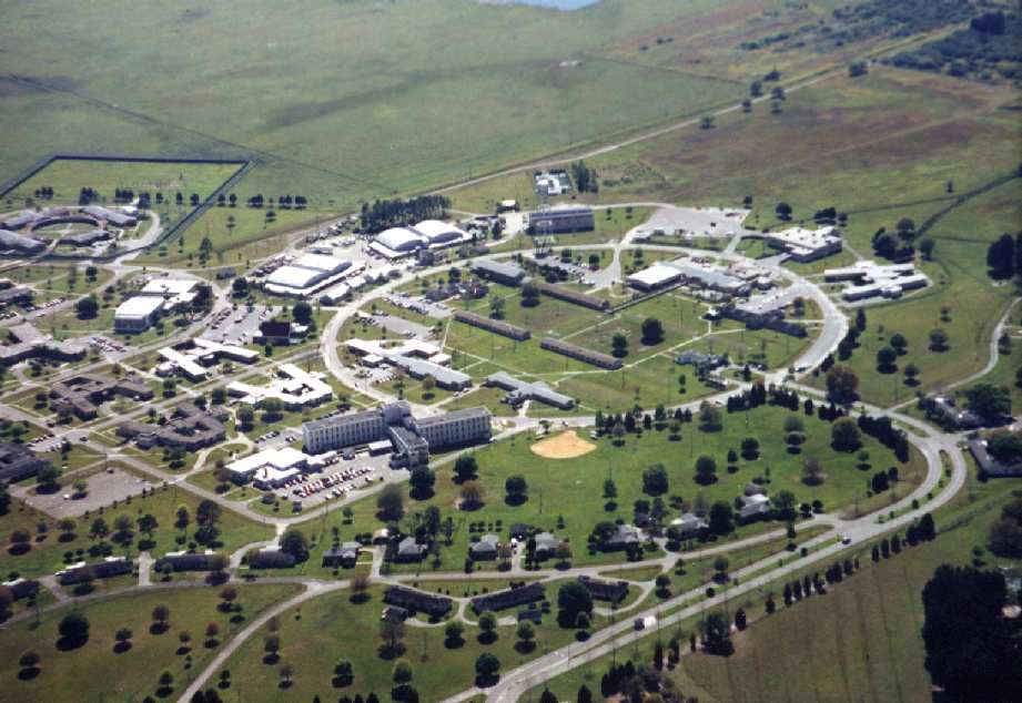
According to Wikipedia, “Carlstrom Field became the site of the G. Pierce Wood Memorial Hospital in 1947.
Many of World War II era buildings remain in use by the hospital, with former 6-plane hangars serving as maintenance buildings.
The band shell, site of dances & other entertainment during the war, remains on the site.”
A 3/3/52 USGS aerial view appears to be the last photo which has been located showing aircraft at Carlstrom Field,
as close inspection reveals what appears to be 3 light single-engine aircraft parked along the row of WW1-era hangars on the east side of the grass airfield.
Carlstrom Field's WW2 buildings were labeled “State Hospital” on a 1957 USGS topo map.
The row of WW1 hangars to the southeast was no longer depicted.
A 1968 aerial photo showed a series of buildings had been constructed to the southeast of Carlstrom Field's WW2-era hangars.
Bill Rose reported that a fly-in & airshow were held at Carlstrom Field to celebrate its 70th anniversary.
According to Hal Thompson, “A landing strip was mowed in the original flying field at Carlstrom Field.
The airshow which featured John Paul Riddle had a fatal accident.
One of the aircraft, doing aerobatics, did a low-level loop, fell directly into the ground and the pilot was killed. I attended this affair.”
According to the FL Aviation Historical Society, “This event occurred on 10/17/87.
The pilot killed was Wayne Fuller, flying an XTRA-230 stunt plane built in Germany.
Ironically, the News Editor bought 2 hot dogs, one for Wayne just before the tragedy.
Wayne stated, 'Once you get acrobatics into your blood you can’t get rid of it.'
He then took-off, scheduled to make 3 rolls while diving from an altitude of less than 1,500', at a 45 degree angle.
He may have lost count as he actually completed 4 rolls & this brought him too close to the ground to pull up.
The event was in celebration of Carlstrom Field’s 70th Anniversary
and the C. Pierce Wood Hospital’s (which is now located on the old field) 40th Anniversary.
Riddle was the guest speaker.”
Bill Rose recalled, “I was approached by the promoter about flying an airshow he was putting together.
I agreed to do so & after many months the details became clear.
Carlstrom Field was celebrating its 70th anniversary & the plan was the mow a section of the site at or near where the runways were originally located
and use that as the runway for the airshow & the display airplanes.
I was asked to fly one of the display airplanes (a replica Fokker Dr-1 Triplane) to Carlstrom and park it for the duration of the event,
then fly it back home to Charlotte County Airport.
I was also flying a Pitts S-1S in a short airshow routine.
I delivered the Triplane to Carlstrom & did several fly-bys along with the other display airplanes, landed & secured the airplane on the show line.
I was then driven to Arcadia Airport where we had staged all the airplanes and pilots prior to the show.
On queue I flew the Pitts to Carlstrom & did my routine, then flew back to Arcadia.”
Bill continued, “After I flew, Mr. Fuller started his routine.
He had taken his airplane to Carlstrom & parked on the show line -
something I was reluctant to do given the crude preparation of the runway & the small tires on the Pitts.
During his routine, Mr. Fuller impacted the ground while doing a multiple snap roll on a 45° down line.
Fortunately I was not there at the time & did not witness the accident.
The accident ended the show & delayed the schedule of events such that the owner of the Fokker Triplane took it back to Charlotte himself
so I could get back to my home airport before dark.”
Bill believes that the grass runway cleared for the airshow
started immediately below south end of Carlstrom's circle of buildings & ran to the southeast.
In the 1994 USGS aerial photo, foundations of First World War hangars were still recognizable along the road on southeast corner of the Carlstrom Field site.
A 1998 aerial view by Lou Thole (author of the book "Forgotten Fields of America"),
looking southwest at the buildings of Carlstrom Field.
A 1998 photo by Lou Thole of one of the remaining hangars at Carlstrom Field.
Lou Thole reported that many WW2-era buildings still remain standing,
including former barracks, the former administration building, and 2 former hangars.
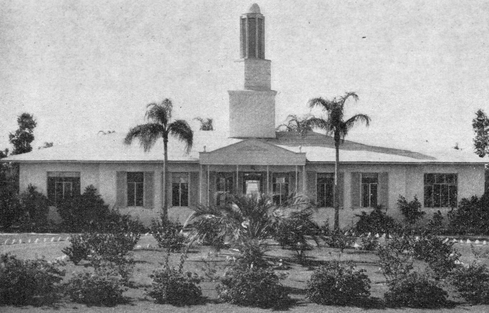
A 1998 photo by Lou Thole of Carlstrom Field's former administration building.
According to Wikipedia, “In 2002, the G. Pierce Wood Memorial Hospital was closed.”
The Carlstrom Field property subsequently was reused as the DeSoto County Juvenile Correctional Complex.
Lou Thole visited the site of Carlstrom Field again in 2003,
but reported that some of the WW2-era buildings were in the process of being torn down.
The outline of Carlstrom Field, as annotated by Chris Kennedy over a 2004 aerial photo.
The DeSoto County Juvenile Correctional Complex on the Carlstrom Field property was closed in 2011.
A 2018 photo looking northwest at the row of concrete foundations of WW1-era hangars on the east side of the Carlstrom Field site.
____________________________________________________
27.203, -81.67 (Northeast of Fort Myers, FL)
A circa 1914-1918 photo of unidentified biplanes at Dorr Field.
Dorr Field was one of 32 Air Service training camps established in 1917 after the United States entry into World War I.
It was named after pilot Stephen Dorr who was killed in a 1917 midair collision,
and was established to support flight training operations at nearby Carlstrom Field.
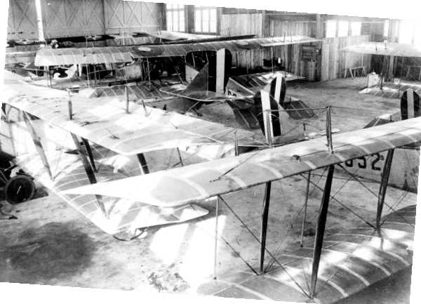
A circa 1914-1918 photo of Curtiss JN-4 Jenny training biplanes inside a Dorr Field hangar.
Dorr Field was closed at the end of WW1 [1918].
The earliest map depiction which has been located of Dorr Field was on the 1919 TIB Military Map of the US (courtesy of Jonathan Westerling).
Dorr Field was no longer depicted on the December 1935 Miami Sectional Chart,
listed in the Airport Directory Company's 1937 Airports Directory (courtesy of Bob Rambo), depicted on the July 1940 Miami Sectional Chart.
Dorr Field was depicted as an “Abandoned Airport” on the May 1941 Miami Sectional Chart (courtesy of Chris Kennedy).
Dorr Field was reactivated on 10/4/41 as one of at least 5 satellite airfields used to support flight training operations at nearby Carlstrom Field,
where the Embry Riddle Academy operated a contract flight training school.
It was assigned to the USAAF East Coast Training Center (later Central Eastern Training Command) as a primary (Level 1) pilot training airfield,
and was operated by Embry-Riddle Corporation under 54th Flying Training Detachment primarily as a training airfield for Royal Air Force flying cadets.
Flying training at Dorr was performed with Fairchild PT-19s as the primary trainer,
but Dorr also had several PT-17 Stearmans & a few P-40 Warhawks assigned.
A 1942 USAAF photo of rows of Stearman PT-17 biplane trainers at Dorr Field (courtesy of David Brooks).
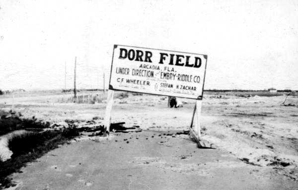
A circa 1942-45 sign for “Dorr Field, under direction of Embry-Riddle Company”.
A circa 1942-45 photo of a row of Vultee BT-13 Valiant trainers at Dorr Field.
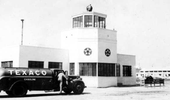
A circa 1942-45 photo of a Texaco fuel truck in front of the Dorr Field control tower.
A circa 1942-45 photo (courtesy of Dallam Oliver-Lee) of Vultee BT-13 Valiant trainers at Dorr Field, showing the control tower & hangars.
The earliest depiction which has been located of the reactivated WW2-era Dorr Field
was on the 1943 Miami Sectional Chart (courtesy of Chris Kennedy).
A 4/16/43 USDA aerial photo of Dorr Field (from the Digital Library Center / University of FL George A. Smathers Libraries, courtesy of Brian Rehwinkel).
The original (WW1-era) layout of the field had apparently consisted of about 14 hangars arrayed in a line along the north end of the field.
By the time of this photo, seven of those original hangars still remained standing.
In the middle of the WW1 hangars, a new complex had been built during the WW2 era,
consisting of a 'lemon-shaped' road in the center of which were constructed a large number of barracks buildings.
Along the south side of this road were 4 arch-roof hangars, and on the south side of the hangars was an asphalt ramp area.
The airfield area (south of the ramp) consisted of a large open grass area.
A close-up of the 4/16/43 USDA aerial photo (courtesy of Brian Rehwinkel) showed about a dozen planes on Dorr Field's ramp.
The 1944 US Army/Navy Directory of Airfields (courtesy of Ken Mercer) described "Dorr, Army" as having a 5,300' unpaved runway.
An undated photo of Dorr Field's Administration Building from the 3/24/44 Embry-Riddle “Fly Paper” (courtesy of Lisa Stanford).

An undated photo of Hangar Inspector Vance Tonkin in front of a North American P-51 Mustang fighter which visited Dorr Field on Field Day,
from the 5/1/44 Embry-Riddle “Fly Paper” (courtesy of Lisa Stanford).
Dorr Field was inactivated on 10/16/44 with the drawdown of AAFTC's pilot training program
and was declared surplus & turned over to the Army Corps of Engineers.
It was eventually discharged to the War Assets Administration (WAA).
Dorr Field & its satellite fields, as depicted on the August 1945 Miami Sectional Chart.
The last aeronautical chart depiction which has been located of Dorr Field was on the February 1947 Miami Sectional Chart.
It depicted Dorr as having a 5,300' unpaved runway.
Dorr Field was no longer depicted on the August 1947 Miami Sectional Chart.
It was evidently not reused for postwar civilian flying, presumably as it was located in too rural of a location.
Both Carlstrom & Dorr Fields were sold to the State of Florida for a total of $1.
The Dorr Field property was eventually reused as the site of the Desoto County Correctional Institution.
A 11/30/50 USGS aerial photo (courtesy of Dallam Oliver-Lee) appeared to show that Dorr's hangars had been removed at some point between 1943-50.
A 3/16/52 USGS aerial photo showed that Dorr's hangars had been removed, with their foundations remaining.
The site of Dorr Field was labeled “State Hospital” on a 1957 USGS topo map.
A 1/26/68 USDA aerial photo (courtesy of Dallam Oliver-Lee) showed the field in an unchanged condition.
A 3/6/78 USGS aerial photo (courtesy of Dallam Oliver-Lee) showed new construction over the site previously occupied by the hangars,
presumably in relation to the property's reuse as a prison.
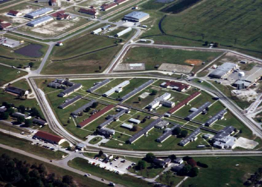
A 1998 aerial view by Lou Thole (author of the book "Forgotten Fields of America"),
looking southeast at the remaining WW2-era airfield buildings on the north end of Dorr Field.
The hangars have been removed, but many of the former WW2-era barracks buildings are still in use.
The foundations of the 4 hangars are visible just beyond the barracks buildings.
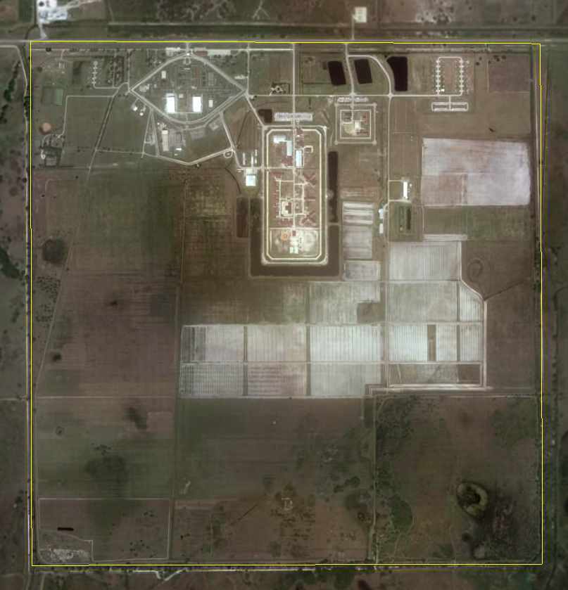
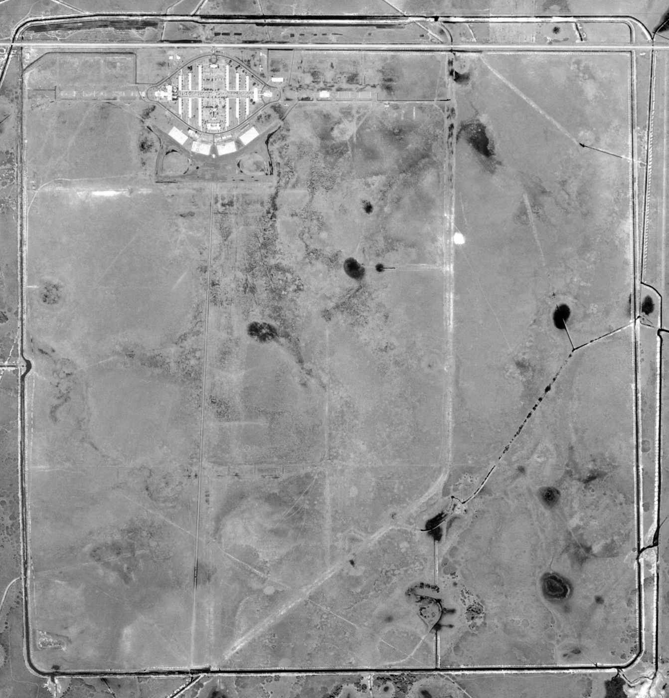
The outline of Dorr Field, as annotated by Chris Kennedy over a circa 2000-2006 aerial photo.
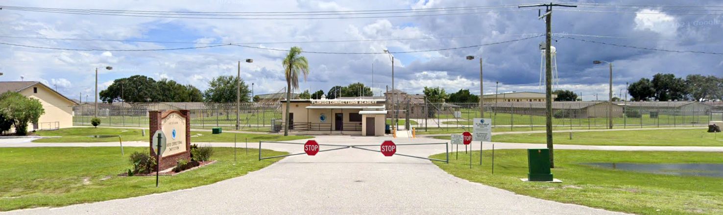
A 2022 photo looking south at the entrance to the Dorr Field site, now the FL Corrections Academy.
The site of Dorr Field is located on the south side of Route 70, eight miles east of Arcadia.
____________________________________________________
Wells Auxiliary Army Airfield #2, Fort Ogden, FL
27.1, -81.92 (Northeast of Fort Myers, FL)
A 1943 USDA aerial photo of Wells Field,
from the Digital Library Center / University of Florida George A. Smathers Libraries (courtesy of Brian Rehwinkel).
Note the presence of at least 2 aircraft, on the northern part of the field.
Wells Field was one of at least 9 satellite airfields which were used during WW2
to support flight training operations at nearby Carlstrom Field,
where the Embry Riddle Academy operated a contract flight training school.
The date of establishment of Wells Field has not been determined.
It was not listed in the Airport Directory Company's 1937 Airports Directory (courtesy of Bob Rambo),
nor was it depicted at all on the May 1941 Miami Sectional Chart (courtesy of Chris Kennedy).
The earliest depiction of Wells Field which has been located
was on the above 1943 USDA aerial photo.
It depicted the field as consisting of an irregularly-shaped grass area, with no buildings or other facilities.
Att least 2 aircraft were seen on the northern part of the field.
The last depiction which has been located still showing Wells Field in use was a 4/16/43 USDA aerial view (courtesy of Dallam Oliver-Lee).
A single aircraft was visible on the north side of the field.
Wells Field was not yet depicted on the February 1945 Miami Sectional Chart.
The only chart depiction which has been located of Wells Field was on the August 1945 Miami Sectional Chart,
which depicted Wells as an auxiliary airfield.
The 1945 AAF Airfield Directory (courtesy of Scott Murdock) described “Carlstrom Field Auxiliary #2 (Welles Field)”
as a 148 acre square property containing a 2,640' square sod all-way landing field.
No hangars were reported at Welles Field, which was described as being owned & operated by private interests.
The date of closure of Wells Field has not been determined.
It parent field, Carlstrom Field, was sold at the end of WW2 to the State of Florida,
but Wells Field may have been abandoned even before then.
It is unknown if Wells Field was ever reused for postwar civilian flying, but it most likely was not.
Wells Field was no longer recognizable on a 12/5/50 USGS aerial view (courtesy of Dallam Oliver-Lee),
with the area having returned to farming.
Wells Field was not depicted at all on the 1957 USGS topo map.
A 1/19/12 aerial (courtesy of Dallam Oliver-Lee) showed the area has been reused extensively for agriculture,
and no recognizable remains of the airfield appear to remain visible.
The site of Wells Field is located northwest of the intersection of Route 17 & Southwest Collins Street.
____________________________________________________
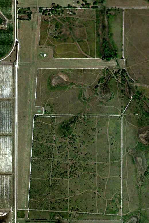
Myrtle Field / Carlstrom Auxiliary Army Airfield #3, Arcadia, FL
27.06, -81.78 (Northeast of Fort Myers, FL)
A 1943 USDA aerial photo of Myrtle Field
from the Digital Library Center / University of Florida George A. Smathers Libraries (courtesy of Brian Rehwinkel).
Myrtle Field was one of at least 9 satellite airfields which were used during WW2
to support flight training operations at nearby Carlstrom Field,
where the Embry Riddle Academy operated a contract flight training school.
The date of establishment of Myrtle Field has not been determined.
It was not listed in the Airport Directory Company's 1937 Airports Directory (courtesy of Bob Rambo),
nor was it depicted at all on the May 1941 Miami Sectional Chart (courtesy of Chris Kennedy).
The earliest depiction of Myrtle Field which has been located was a 4/16/43 USDA aerial photo
from the Digital Library Center / University of Florida George A. Smathers Libraries (courtesy of Brian Rehwinkel).
It depicted the field as consisting of an rectangular grass area (surrounded by a set of perimeter roads),
with no buildings or other facilities.
Two aircraft were visible on the western part of the field.
Myrtle Field was not yet depicted on the February 1945 Miami Sectional Chart.
The only chart depiction which has been located of Myrtle Field was on the August 1945 Miami Sectional Chart,
which depicted Myrtle as an auxiliary airfield.
The 1945 AAF Airfield Directory (courtesy of Scott Murdock) described “Carlstrom Field Auxiliary #3 (Myrtle Field)”
as a 161 acre square property containing a 2,640' square sod all-way landing field.
No hangars were reported at tMyrtle Field , which was described as being owned & operated by private interests.
The date of closure of Myrtle Field has not been determined.
It parent field, Carlstrom Field, was sold at the end of WW2 to the State of Florida,
but Myrtle Field may have been abandoned even before then.
It is unknown if Myrtle Field was ever reused for postwar civilian flying, but it most likely was not.
An 11/30/50 USGS aerial photo (courtesy of Dallam Oliver-Lee) showed the site of Myrtle Field had been reused for agriculture,
and no recognizable remains of a former airfield appeared to remain visible.
Myrtle Field was not depicted at all on the 1956 USGS topo map.
A 12/10/10 aerial photo (courtesy of Dallam Oliver-Lee) showed no remaining trace of Myrtle Field.
The site of Myrtle Field is located on the east side of Route 31, approximately 12 miles southeast of Arcadia, FL.
____________________________________________________
Southwest Auxiliary Army Airfield #4, Fort Ogden, FL
27.05, -81.85 (Northeast of Fort Myers, FL)
A 1943 USDA aerial photo of Southwest Field,
from the Digital Library Center / University of Florida George A. Smathers Libraries (courtesy of Brian Rehwinkel).
Note the presence of what may have been at least 1 aircraft, on the southern part of the field.
Southwest Field was one of at least 9 satellite airfields which were used during WW2
to support flight training operations at nearby Carlstrom Field,
where the Embry Riddle Academy operated a contract flight training school.
The date of establishment of Southwest Field has not been determined.
It was not listed in the Airport Directory Company's 1937 Airports Directory (courtesy of Bob Rambo),
nor was it depicted at all on the May 1941 Miami Sectional Chart (courtesy of Chris Kennedy).
The earliest depiction of Southwest Field which has been located
was on the above 1943 USDA aerial photo.
It depicted the field as consisting of an rectangular grass area (bordered by perimeter roads),
with no buildings or other facilities.
Southwest Field was not yet depicted on the February 1945 Miami Sectional Chart.
The only chart depiction which has been located of Southwest Field was on the August 1945 Miami Sectional Chart,
which depicted Southwest as an auxiliary airfield.
The 1945 AAF Airfield Directory (courtesy of Scott Murdock) described “Carlstrom Field Auxiliary #4 (Southwest Field)”
as a 143 acre square property containing a 2,640' square sod all-way landing field.
No hangars were reported at Southwest Field, which was described as being owned & operated by private interests.
The date of closure of Southwest Field has not been determined.
It parent field, Carlstrom Field, was sold at the end of WW2 to the State of Florida,
but Southwest Field may have been abandoned even before then.
It is unknown if Southwest Field was ever reused for postwar civilian flying, but it most likely was not.
Southwest Field was not depicted at all on the 1956 USGS topo map.
No trace was recognizable of Southwest Field on a 1999 USGS aerial photo.
A 2016 aerial view showed no trace of Southwest Field.
The precise location of the former Southwest Field has not been determined,
but judging by its depiction on the 1945 Miami Sectional Chart,
it would be appear to have been located approximately 6 miles east-southeast of Fort Ogden, FL.
The area has been reused extensively for agriculture, and no recognizable remains of a former airfield appear to remain visible.
____________________________________________________
Dorr Auxiliary Army Airfield #2, Arcadia, FL
27.16, -81.63 (Northeast of Fort Myers, FL)
A 4/16/43 USDA aerial photo of Dorr Aux #2,
(from the Digital Library Center / University of Florida George A. Smathers Libraries, courtesy of Brian Rehwinkel).
Dorr Aux #2 was one of at least 9 satellite airfields which were used during WW2
to support flight training operations at nearby Dorr Field,
where the Embry Riddle Academy operated a contract flight training school.
The date of establishment of Dorr Aux #2 has not been determined.
It was not listed in the Airport Directory Company's 1937 Airports Directory (courtesy of Bob Rambo),
nor was it depicted at all on the May 1941 Miami Sectional Chart (courtesy of Chris Kennedy).
The earliest depiction of Dorr Aux #2 which has been located was a 4/16/43 USDA aerial view
(from the Digital Library Center / University of Florida George A. Smathers Libraries, courtesy of Brian Rehwinkel).
It depicted Dorr Aux #2 as a roughly rectangular grass area, with no buildings or other facilities.
Dorr Aux #2 was not yet depicted on the February 1945 Miami Sectional Chart.
The only chart depiction which has been located of Dorr Aux #2 was on the August 1945 Miami Sectional Chart,
which depicted Dorr Aux #2 as an auxiliary airfield.
The date of closure of Dorr Aux #2 has not been determined.
It parent field, Dorr Field, was sold at the end of WW2 to the State of Florida,
but Dorr Aux #2 may have been abandoned even before then.
It is unknown if Dorr Aux #2 was ever reused for postwar civilian flying, but it most likely was not.
A 11/27/50 USDA aerial photo (courtesy of Dallam Oliver-Lee)
showed the site of Dorr Auxiliary Airfield #2 to remain unchanged, but did not show any sign of recent usage.
Dorr Auxiliary Airfield #2 was not depicted at all on the 1956 USGS topo map.
A 12/28/10 aerial view (courtesy of Dallam Oliver-Lee) showed that amazingly the site of Dorr Aux #2 had changed remarkably little in 67 years.
The roughly square outline of the airfield was still recognizable, along with the east/west lines (?) which run through the property.
The site of Dorr Aux #2 is located approximately 4 miles south of Route 70, 2 miles southeast of the site of Dorr Field.
Thanks to Chris Kennedy for locating the site of the field.
____________________________________________________
Dorr Auxiliary Army Airfield #3, Arcadia, FL
27.26, -81.61 (Northeast of Fort Myers, FL)
A 4/16/43 USDA aerial photo of Dorr Aux #3 (from the Digital Library Center / University of FL George A. Smathers Libraries, courtesy of Brian Rehwinkel).
Dorr Aux #3 was one of at least 9 satellite airfields which were used during WW2
to support flight training operations at nearby Dorr Field,
where the Embry Riddle Academy operated a contract flight training school.
The date of establishment of Dorr Aux #3 has not been determined.
It was not listed in the Airport Directory Company's 1937 Airports Directory (courtesy of Bob Rambo),
nor was it depicted at all on the May 1941 Miami Sectional Chart (courtesy of Chris Kennedy).
The earliest depiction of Dorr Aux #3 which has been located
was on a 4/16/43 USDA aerial photo (from the Digital Library Center / University of FL George A. Smathers Libraries, courtesy of Brian Rehwinkel).
It depicted the field as consisting of an roughly rectangular grass area, with no buildings or other facilities.
A total of 4 aircraft were visible on the field.
Dorr Aux #3 was not yet depicted on the February 1945 Miami Sectional Chart.
The only chart depiction which has been located of Dorr Aux #3 was on the August 1945 Miami Sectional Chart,
which depicted Dorr Aux #3 as an auxiliary airfield.
The date of closure of Dorr Aux #3 has not been determined.
It parent field, Dorr Field, was sold at the end of WW2 to the State of Florida,
but Dorr Aux #3 may have been abandoned even before then.
It is unknown if Dorr Aux #3 was ever reused for postwar civilian flying, but it most likely was not.
A 4/7/50 USDA aerial photo (courtesy of Dallam Oliver-Lee)
showed the field remain unchanged, but did not show any sign of recent usage.
Dorr Auxiliary Airfield #3 was not depicted at all on the 1953 USGS topo map.
A 1/28/58 USDA aerial photo (courtesy of Dallam Oliver-Lee)
showed the field remain unchanged, but did not show any sign of recent usage.
A 3/6/78 USGS aerial photo (courtesy of Dallam Oliver-Lee)
showed the landscape had been completely changed, with rectangular farming fields covering the site of Dorr Aux #3, erasing any trace of the airfield.
The outline of Dorr Aux #3, as annotated by Chris Kennedy over a circa 2000-2006 aerial photo.
The site has been reused for agriculture, with not a trace of the former airfield still perceptible.
The site of Dorr Aux #3 is located approximately 4 miles south of Route 70, 2 miles northeast of the site of Dorr Field.
____________________________________________________
Dorr Auxiliary Army Airfield #4 / Bright Hour Ranch Airfield, Arcadia, FL
27.18, -81.75 (Northeast of Fort Myers, FL)
A 4/16/43 USDA aerial photo of Dorr Aux #4
(from the Digital Library Center / University of FL George A. Smathers Libraries, courtesy of Brian Rehwinkel).
Dorr Aux #4 was one of at least 9 satellite airfields which were used during WW2
to support flight training operations at nearby Dorr Field,
where the Embry Riddle Academy operated a contract flight training school.
The date of establishment of Dorr Aux #4 has not been determined.
It was not listed in the Airport Directory Company's 1937 Airports Directory (courtesy of Bob Rambo),
nor was it depicted at all on the May 1941 Miami Sectional Chart (courtesy of Chris Kennedy).
The earliest depiction of Dorr Aux #4 which has been located
was on a 4/16/43 USDA aerial photo (from the Digital Library Center / University of FL George A. Smathers Libraries, courtesy of Brian Rehwinkel).
It depicted the field as consisting of an roughly rectangular grass area, with no buildings or other facilities.
Remarkably, it depicted at least 2 aircraft on the field.
Dorr Aux #4 was not yet depicted on the February 1945 Miami Sectional Chart.
The only chart depiction which has been located of Dorr Aux #4 was on the August 1945 Miami Sectional Chart,
which depicted Dorr Aux #4 as an auxiliary airfield.
The date of closure of Dorr Aux #4 has not been determined.
It parent field, Dorr Field, was sold at the end of WW2 to the State of Florida,
but Dorr Aux #4 may have been abandoned even before then.
A 11/27/50 USDA aerial photo (courtesy of Dallam Oliver-Lee) & a 3/16/52 USDA aerial photo (courtesy of Dallam Oliver-Lee)
showed the field remain unchanged, but did not show any sign of recent usage.
Dorr Auxiliary Airfield #4 was not depicted at all on the 1957 USGS topo map.
The Dorr Aux #4 Airfield began to be reused as a civilian general aviation airfield at some point between 1952-58,
as a 2/8/58 USDA aerial photo (courtesy of Dallam Oliver-Lee) showed 2 new grass runways on the field,
and a single-engine aircraft parked at the north end of the new north/south strip.
A 1/22/60 USAF aerial photo (courtesy of Dallam Oliver-Lee) showed 3 grass over the former Dorr Aux #4 airfield.
At some point between 1958-60 a much longer unpaved runway
had been established from the southwestern edge of the Dorr Aux #4 airfield onto the adjacent property to the north,
connecting with another new east/west runway on the north side.
A 1/26/68 USDA aerial photo (courtesy of Dallam Oliver-Lee) showed the airfield in an unchanged configuration.
A 3/6/78 USGS aerial photo (courtesy of Dallam Oliver-Lee) showed that a small hangar had been added at some point between 1968-78,
northeast of the intersection of the 2 new runways.
The last photo which has been located showing the Dorr Aux #4 airfield still in use presumably as an airfield
was a 2/29/04 aerial photo (courtesy of Dallam Oliver-Lee).
Aviation use of the airfield presumably ended at some point between 2004-2005,
as a 12/31/05 USGS aerial photo (courtesy of Dallam Oliver-Lee) showed a larger building constructed over the location of the former hangar,
and a road cutting across the east/west runway.
A 12/21/08 aerial photo (courtesy of Dallam Oliver-Lee) showed a pond had been added at the intersection of the 2 newer runways.
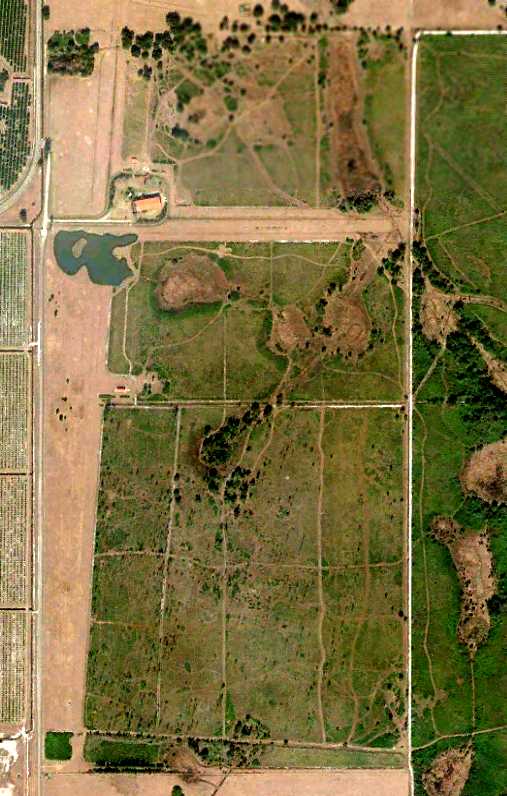
A 12/28/10 aerial photo (courtesy of Dallam Oliver-Lee) showed the outline of the former Dorr Aux #4 airfield on the south end,
and the remains of the 2 newer civilian runways on the northwest side.
As of 2015, street maps labeled the site of Dorr Auxiliary Airfield #4 as Bright Hour Ranch Airport.
The site of Dorr Aux #4 is located 2 miles south of Route 70, six miles east of Arcadia, FL.
____________________________________________________
Or if you prefer to contact me directly concerning a contribution (for a mailing address to send a check),
please contact me at: paulandterryfreeman@gmail.com
If you enjoy this web site, please support it with a financial contribution.
____________________________________________________
This site covers airfields in all 50 states.
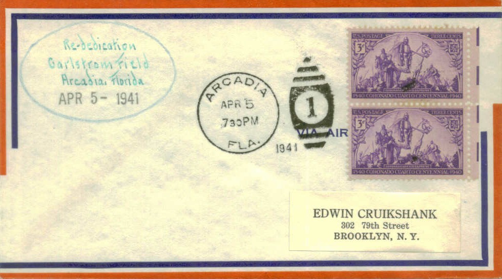