Abandoned & Little-Known Airfields:
Washington: Southern Seattle area
© 2002, © 2026 by Paul Freeman. Revised 2/1/26.
This site covers airfields in all 50 states: Click here for the site's main menu.
____________________________________________________
Please consider a financial contribution to support the continued growth & operation of this site.
Bellevue Airport (revised 1/31/26) - Cedar Grove Airpark (revised 9/1/24) - Issaquah Sky Ranch / Seattle Sky Ranch / Issaquah Skyport (revised 2/1/26) - Kent Airport (original location) (revised 3/26/13)
Lake Airpark (revised 4/18/22) - Valley Airport / Kent Airport (2nd location) / Smith Brothers Airport (revised 4/28/20) - Wax Orchards Airport (added 8/31/25)
____________________________________________________
Wax Orchards Airport (WA69), Vashon, WA
47.4,-122.499 (West of Seattle, WA)
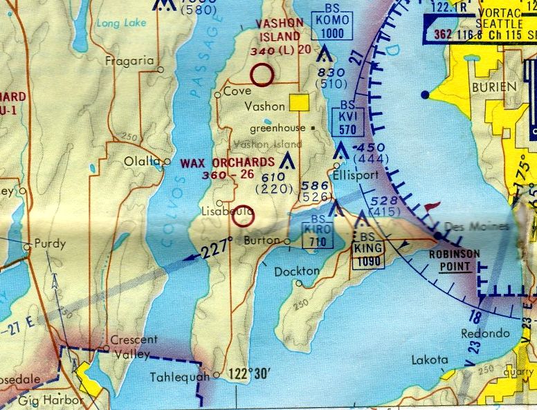
Wax Orchards Airport, as depicted on the February 1973 Seattle Sectional Chart.
This small general aviation airport on an island West of Seattle was evidently established at some point between 1964-68,
as it was not yet depicted on a 1964 aerial photo.
The earliest depiction which has been located of Wax Orchards Airport was on a 1968 aerial photo.
It depicted a single unpaved north/south runway.
Wax Orchards Airport was not yet depicted on the June 1971 Seattle Sectional Chart.
The earliest depiction which has been located of Wax Orchards Airport was on the February 1973 Seattle Sectional Chart.
It depicted Wax Orchards as a public-use airport having a 2,600' unpaved runway.
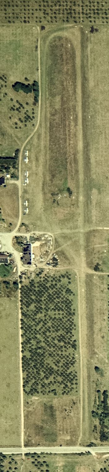
The earliest photo which has been located of Wax Orchards Airport was a 9/5/77 USGS aerial photo,
which depicted it as having a single north/south unpaved runway & 6 light single-engine aircraft were parked on its west side.
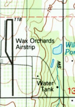
The earliest topo map depiction which has been located of Wax Orchards Airport was on the 1983 USGS topo map.
It depicted “Wax Orchards Airstrip” as having a single north/south runway with a taxiway on the northwest side.
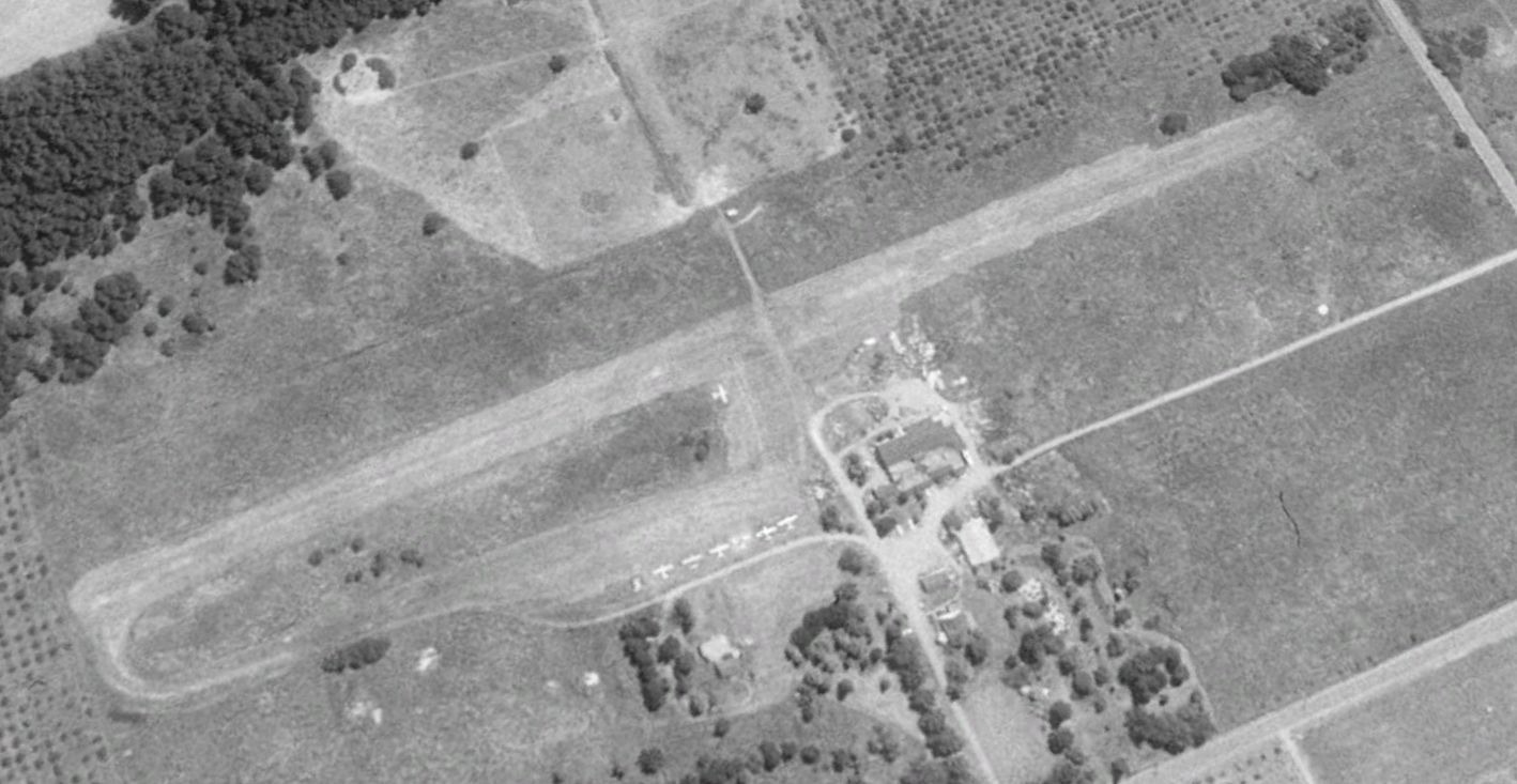
A 1990 USGS aerial view looking southeast depicted Wax Orchards Airport at perhaps its zenith of popularity, with 7 light single-engine aircraft parked on its west side.
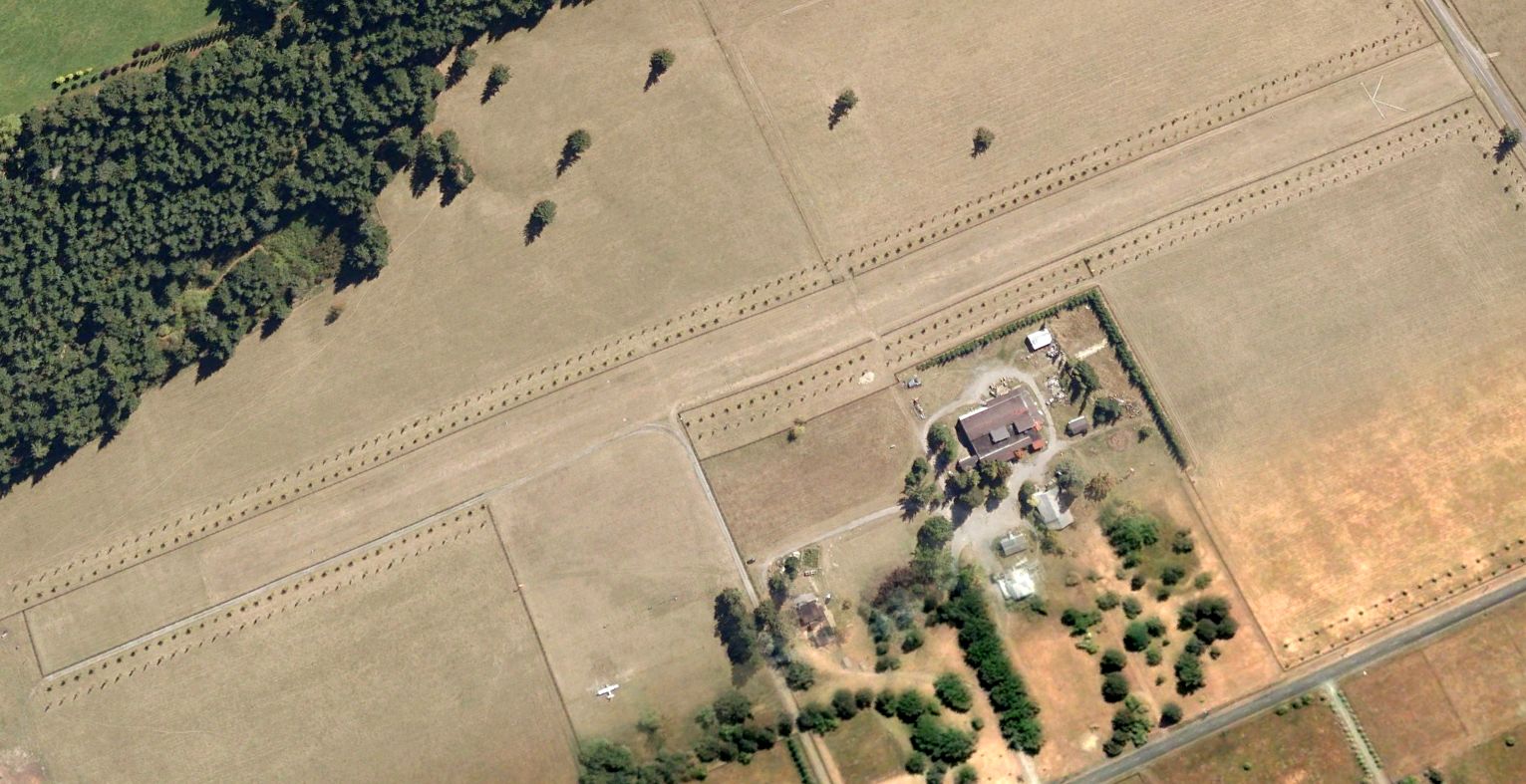
The last photo which has been located showing aircraft at Wax Orchards Airport was a 2007 aerial view looking southeast.
Only 1 light single-engine aircraft remained on the field.
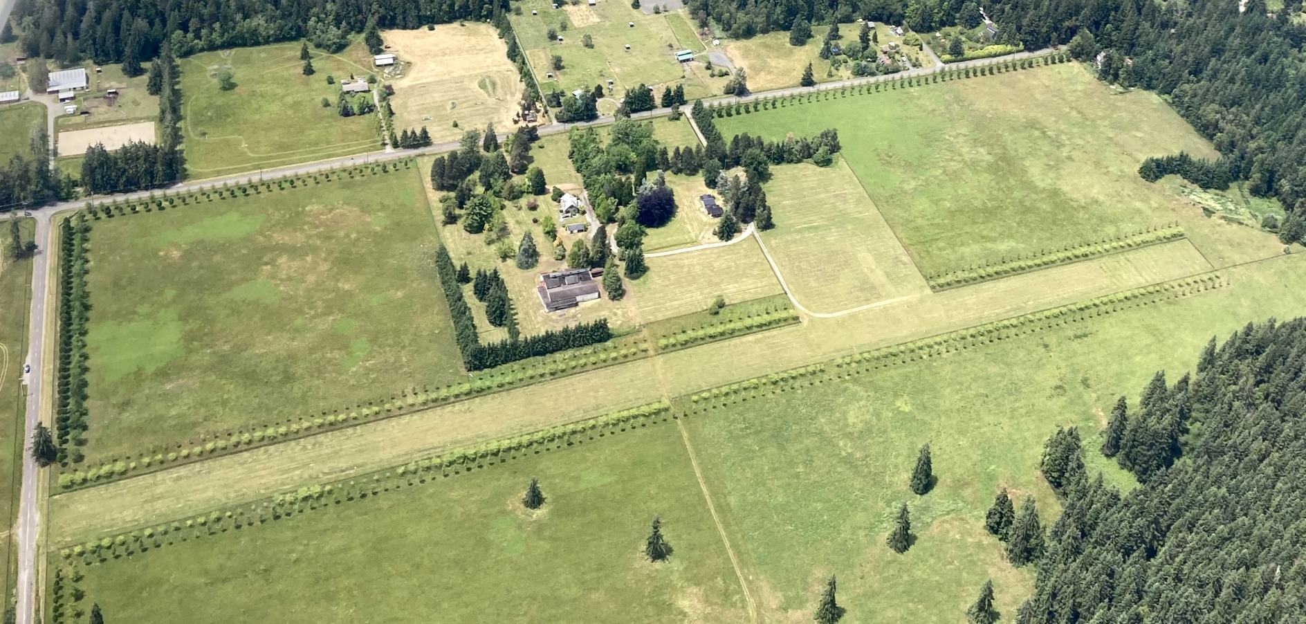
A June 2020 aerial view by Daryl Greaser depicted Wax Orchards Airport as remaining intact, but sadly devoid of aircraft.
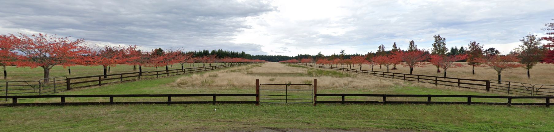
An October 2021 photo looking north showed the former Wax Orchards Airport runway as being fenced off.
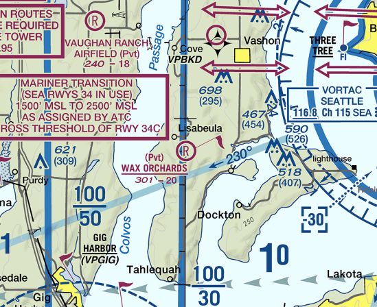
The last aeronautical chart depiction which has been located of Wax Orchards Airport was on the March 2021 Seattle Terminal Chart (courtesy of Daryl Greaser).
It depicted Wax Orchards as a private airfield having a 2,000' unpaved runway.
Wax Orchards Airport was evidently closed (for reasons unknown) at some point between 2021-2022, as it was no longer depicted on the March 2022 Seattle Terminal Chart.
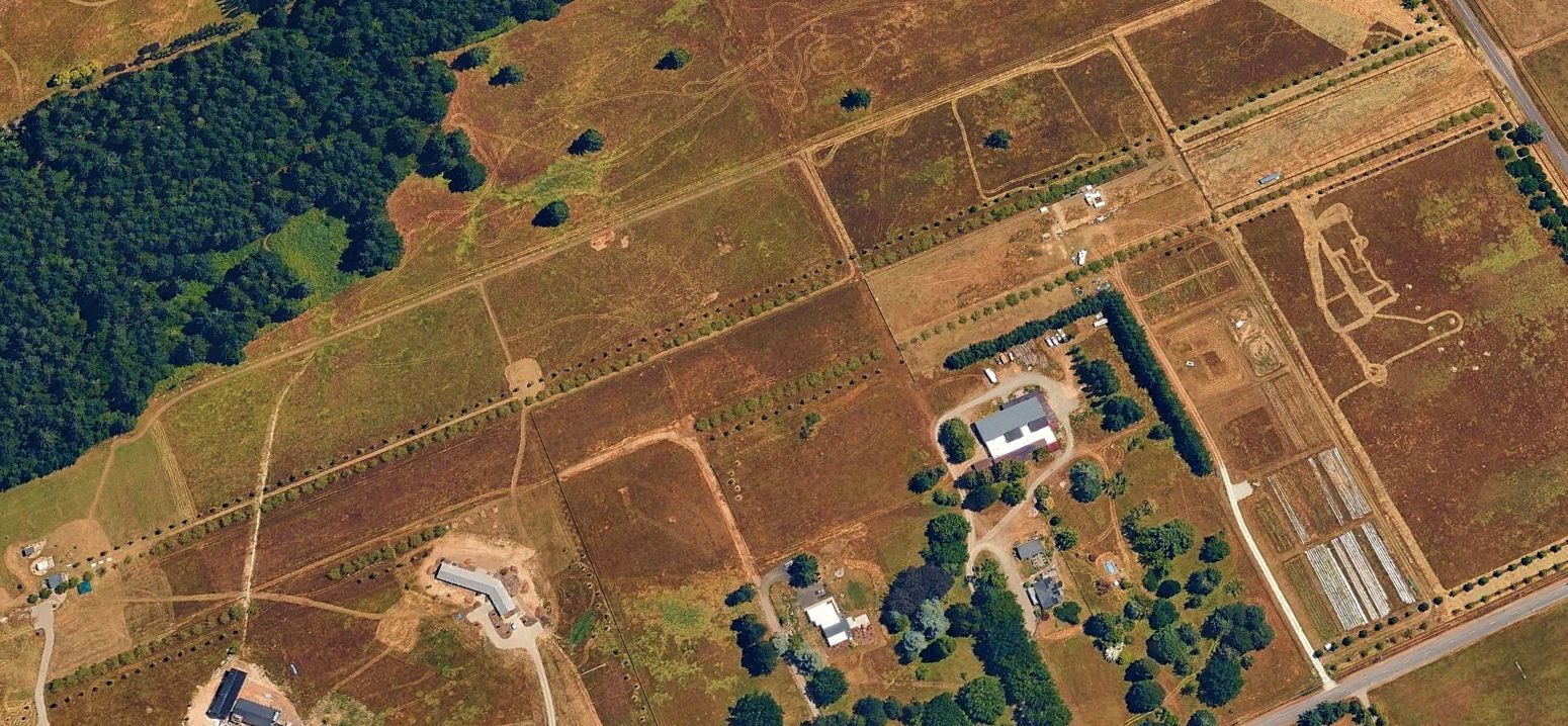
A 2024 aerial view looking southeast showed several small buildings had been built over the center of the former Wax Orchards Airport runway.
Thanks to Daryl Greaser for pointing out this airfield.
____________________________________________________
Kent Airport (original location), Kent, WA
47.37, -122.24 (South of Seattle, WA)

Kent Airport, as depicted on 1920 Army Air Service map (courtesy of David Brooks).
The date of establishment of Kent Airport has not been determined.
The earliest depiction which has been located of Kent Airport was on 1920 Army Air Service map (courtesy of David Brooks).
According to Scott Armstrong, “The airfield was originally started in 1924 by Herb Munter,
Boeing's first test pilot & an all-around interesting guy (taught himself to fly in an airplane that he designed & built himself as a teenager).”
A 1925 Commerce Department Airway Bulletin (courtesy of Jonathan Westerling)
described Kent Airport as an emergency field “used by Boeing Airplane Company”,
measuring 1,600' x 500', having a hangar,
and “Reported by National Aircraft Underwriters Association 1/31/22.”
According to Scott Armstrong, “Apparently the Boeing Museum of Flight has some pictures of Herb Munter's original hangar.
However, his hangars & airplanes burned to the ground in a fire,
and the site returned to pasture for several years until 1928,
when my great-grandfather Duffy & the Becvar brothers started the Kent Flying Service from the same site.
This story is told in a local newspaper clipping from 1928. A very interesting & nostalgic read.”

A circa 1928-31 photo (courtesy of Scott Armstrong) of Scott's great-grandfather, Kent Flying Service co-founder Duffy Armstrong.
According to an article by Linda Wagner of the Greater Kent Historical Society (courtesy of Scott Armstrong),
“In May of 1928 the Kent Flying Service began with George, Chuck, and Lou Becvar along with Lloyd 'Duffy' Armstrong.
The Kent Airport was located on 53 acres near 259th & 78th with 2 sod-surfaced runways & a small hangar.
The business offered student training, passenger flights & advertising (dropping leaflets from the plane)."
According to Scott Armstrong, “In July 1928, the Kent Flying Service acquired a faster & more modern Waco 10 in addition to the aging Jenny.
As of December 1928, the Kent Flying Service had 10 students taking flight lessons,
and was active in dropping leaflets to advertise aviation movies in local theaters.”

A circa 1920s Commerce Department Airway Bulletin (courtesy of Scott Armstrong)
depicted Kent Airport as having 2 perpendicular unpaved runways, measuring 2,200' northwest/southeast & 1,630' northeast/southwest.
A small building appeared to be depicted at the southwest & southwest corners of the airfield.

According to the book “Seattle's Commercial Aviation: 1908-1941” by Ed Davies & Steve Ellis,
“In 1928 the Becvar brothers started Kent Flying Service with this World War 1 surplus Curtiss JN-4H.”

A circa 1928-31 photo (courtesy of Scott Armstrong) of Louie Becvar in the back seat of a Waco 10a biplane marked “Kent Flying Service”.

A circa 1928-31 photo (courtesy of Scott Armstrong) of Louie Becvar, Duffy Armstrong, Chuck Becvar, and George Becvar in front of a Jenny biplane at Kent Airport.

A circa 1928-31 advertisement (courtesy of Scott Armstrong) for the Kent Flying Service.

A circa 1928-31 photo (courtesy of Scott Armstrong) of a Jenny biplane at Kent Airport.

A 6/22/29 Kent Flying Service Aviator's Certificate for Charles Becvar Jr, signed by instructor George Becvar (courtesy of Scott Armstrong).
According to an article by Linda Wagner of the Greater Kent Historical Society (courtesy of Scott Armstrong),
“They ended their business [Kent Flying Service] in 1931 at the height of the Great Depression,
with a clean, safe record – no accidents or injuries.”
Scott Armstrong reported, “According to both Jack Becvar & my grandpa Ron Armstrong,
after the Kent Flying Service folded in 1931, the airfield returned to pasture & the airport was no more.”
Kent Airport was no longer listed among active airports in the 1931 Commerce Department Airway Bulletin #2 (courtesy of David Brooks).
A 1936 aerial photo showed the Kent Airport site remained an open field, on which the faintest traces of the 2 runways could still be perceived.
Buildings at the southwest & southeast corners of the property may have dated from its airport days.
Scott Armstrong reported, “Jack Becvar stated that some years later, the Lynch Furniture Manufacturing Company was located on the site of the airfield.”
A 1940 aerial photo showed the Kent Airport site remained an open field.
The buildings remained at the southwest corner, but the building at the southeast corner had been removed at some point between 1936-40.
A 1964 aerial photo showed 2 large buildings had been built at some point between 1940-64 on the northeast side of the airport property.
The possible airport-related buildings remained at the southwest corner.

Although a 7/5/12 aerial view did not show any obvious trace of Kent Airport, it is possible that some of the small building at bottom-center date from it's airport days.
Scott Armstrong reported in 2013 that the Kent Airport property “now appears to be the site of A-1 Pallets Inc.”
The site of the original location of Kent Airport is located north of the intersection of South 259th Street & 3rd Avenue South.
____________________________________________________
Valley Airport / Kent Airport (2nd location) / Smith Brothers Airport, Kent, WA
47.36, -122.24 (South of Seattle, WA)

Valley Airport, as depicted on the September 1944 Seattle Sectional Chart.
Valley Airport was evidently established at some point in 1944,
as it was not yet depicted at this location on a 1940 aerial photo or the May 1944 Seattle Sectional Chart..
The earliest depiction which has been located of Valley Airport was on the September 1944 Seattle Sectional Chart,
which depicted it as a commercial/municipal airport.
Apparently this airport was only briefly known as Valley Airport -
it shortly became renamed Kent Airport – as it was only a half-mile to the southwest of the location of the 1920s-era Kent Airport.

The earliest photo which has been located of this location of Kent Airport was a 1946 aerial view looking northeast (courtesy of Owen Blauman).
For an airport that may have been less than a year old,
it was amazingly elaborate, with no less than 30 individual hangars along the east side,
and a larger hangar & 2 other buildings on the southwest side.
Over 2-dozen single-engine aircraft were visible on both sides of the field,
which consisted of a grass north/south runway bracketed on either side by parallel perimeter roads.
Owen Blauman recalled, “The Kent Airport was north of current Auburn airport.
My dad said the Smith brothers owned it - local dairy farmers.
They decided to build airplanes at the field for a manufacturer.
He said they build them in a large hangar on the airfield & the the T-hangars across the runway came later.”

A 1946 photo (courtesy of Owen Blauman) looking southwest at 3 Aeroncas & several airport buildings on the muddy southwest side of Kent Airport.
Scott Armstrong reported, “My grandpa Ron recalls that when he was a kid,
his father Duffy (of the Kent Flying Service) kept a Piper J-3 Cub here & took him up for rides from time to time.”

The earliest topo map depiction which has been located of Kent Airport was on the 1949 USGS topo map.
It depicted Kent Airport as having a few small buildings along the southwest side, and a row of many small buildings along the southeast side.
Scott Armstrong reported, “Grandpa Ron confirmed that there was only one grass runway. The lines on the topo map are perimeter roads.”

A 5/28/57 USGS aerial view depicted Kent Airport as having a north/south runway bracketed on either side by parallel perimeter roads.
A row of many small buildings was located along the southeast side.

The earliest aeronautical chart depiction which has been located of Kent Airport was on the April 1959 Seattle Sectional Chart (courtesy of Paul Columbus).
It depicted Kent as a private airfield having a 2,900' unpaved runway.

Kent Airport, as depicted on a 1962 street map (courtesy of Kevin Walsh).
Kent Airport may have gone through a period of temporary closure, as it was not depicted at all on the October 1962 Seattle Sectional Chart (courtesy of Steve Martin).
A 1964 aerial view depicted a total of 17 light aircraft parked on the southeast side of Kent Airport.
A single longer hangar had been added at some point between 1949-64
to the north side of the long row of individual hangars along the southeast side.

The June 1965 Seattle Sectional Chart (courtesy of Ron Kunse) depicted Kent Airport as having a single paved north/south 2,900' runway.

The last aeronautical chart depiction which has been located of Kent Airport was on the 1968 Seattle Sectional Chart.
It depicted Kent as having a single paved north/south 2,700' runway.

The last photo which has been located of Kent Airport was a 9/2/68 USGS aerial view.
Ironically, it depicted Kent Airport at perhaps its zenith of popularity, with a total of 31 light aircraft parked on the southeast side.
The building configuration remained the same as seen in the 1964 aerial photo.

The last topo map depiction which has been located of Kent Airport was on the 1968 USGS topo map.
It depicted Kent Airport as having a north/south runway bracketed on either side by parallel perimeter roads.
The row of many small buildings previously depicted along the southeast side was gone, replaced by only 3 small building & one longer building.
Kent Airport was presumably closed (for reasons unknown) at some point between 1968-69,
as it was no longer depicted on the December 1969 Seattle Sectional Chart.
Kent Airport's former 2 runways were still depicted on the 1976 USGS topo map, but it was no longer labeled as an airport.
All traces of Kent Airport had disappeared from a 1980 aerial photo.
A large industrial building had been constructed over the middle portion of the airport site,
with a railroad line having been built over the eastern portion.

A 7/5/12 aerial view did not show any trace of Kent Airport remaining.
Owen Blauman reported in 2013, “Today the Smith brothers [Kent Airport founders] operate a dairy farm located west of the old airport.”
The site of Kent Airport is located northeast of the intersection of Route 167 & South 277th Street.
____________________________________________________
47.57, -122.19 (Northeast of Renton, WA)

A 1946 aerial view of Lake Airpark (courtesy of Dave Field).
According to Dave Field, a 1936 aerial photo showed this property mostly being used for agriculture.
Lake Airpark was not yet depicted on the April 1945 Seattle Sectional Chart.
Owen Blauman recalled, “Lake Air Park... was located in the Newport neighborhood.
According to my dad, he thought it began when the surrounding area was primarily agricultural & the farmer was a pilot.
It was about a 2,000' unpaved runway. My Dad [Bruce Blauman] had a hangar there.
The approach [from the south] was over the water. With a big unique-sounding radial engine on his surplus WWII plane, he began the approach.
He said there were a couple people in a little fishing boat on Lake Washington near the airfield.
Apparently the fisherman didn’t know there was an airport there. When they saw & heard the airplane heading for them on approach, they jumped overboard.”
The earliest depiction which has been located of Lake Airpark was a 1946 aerial view (courtesy of Dave Field).
It depicted Lake as having a single paved northeast/southwest runway with a parallel taxiway.
Two single-engine planes & a small buildings were visible on the northeast side.

A 1946 photo of Rich Shankland's father Donn Shankland in his Ryan PT-22 N58614 at Lake Airpark.
Rich recalled, “My Dad & me used to hang out at Lake Air in the late 1940s - early 1950s.
He had a couple of planes tied down there: a Cessna 140 N89934 and a Ryan PT-22 N58614.
The PT-22 he bought new (war surplus) for $600.
The fellow propping the engine is either Sterril (Sterrel?) or 'Howdy' Addams (Adams?); 2 brothers who ran the FBO at Lake Air.
The office, snack bar, lounge, etc. are in the building behind.
I remember playing & swimming on the beautiful gravel beach with planes landing (or taking off) overhead.
My dad broke his arm in at least a half-dozen places one time while hand-propping the Ryan.”

The earliest aeronautical chart depiction which has been located of Lake Airpark was on the October 1948 Seattle Sectional Chart (courtesy of Chris Kennedy).
It depicted Lake as having a 2,100' unpaved runway.

A 1940s photo of Bruce Blauman in front of a military surplus Vultee BT-13 at Lake Airpark (courtesy of Owen Blauman).

A circa 1940s photo of 1940 Waco UPF-7 N29300 (serial # 5327) in front of a hangar with “Lake-Air” painted on its roof at Lake Airpark (courtesy of Owen Blauman).
Marilynn Laird reported, “The Waco belonged to my father Mark Hoskins.”

A circa 1940s coupon for an airplane ride from Lake Airpark (courtesy of Owen Blauman).

The 1950 USGS topo map depicted Lake Airpark as a single paved northeast/southwest runway (labeled simply as 'Airfield')
with a parallel taxiway, and 3 small buildings along the northeast side.

The last photo which has been located showing Lake Airpark in operation was a 1953 aerial view looking north (courtesy of Owen Blauman).
It depicted Lake Airpark as having a single paved northeast/southwest runway with a parallel taxiway.
Several light planes & a few small buildings were visible on the northeast side.

The last aeronautical chart depiction which has been located of Lake Airpark was on the April 1955 Seattle Sectional Chart.
It depicted Lake as having a 2,000' unpaved runway.
Lake Airpark was evidently closed at some point in 1955, as it was no longer depicted on the November 1955 Seattle Sectional Chart.

A circa 1950s aerial view of Lake Airpark, annotated to show a proposed Newport Part Site (courtesy of Owen Blaumann).

A diagram from a 9/19/57 newspaper article (courtesy of Lee Corbin) showed a plan for a proposed Newport County Park to be constructed on the site of Lake Airpark,
including a parking lot converted from the “present runway”.
Apparently this proposed park was never built, for reasons unknown.
Owen Blauman recalled, “The property was sold sometime around 1957 or 1958 and Lake Air closed soon after.”
When Lake Air closed, my father tore down a hangar he had built for himself there, and then built his house on Mercer Island from the ground up using the lumber he had salvaged.”
Owen Blauman recalled, “In about 1964, the current canals were cut & the planned neighborhood development, now known as Newport Shores, was built.”
A 1964 USGS aerial photo showed that the site of Lake Airpark had been transformed into a residential neighborhood, with several canals having been cut into the former airport property.
No trace remained of Lake Airpark.

A 7/6/12 aerial view did not show any trace of Lake Airpark remaining.
Owen B. reported in 2013, “Today there are carved canals, homes, yacht moorage & a boat fuel dock” at the site of Lake Airpark.
Rich Shankland reported in 2018, “This is now probably some of the most expensive real estate in the Seattle suburbs, with dock space for your yacht at the door of your house.”
The site of Lake Airpark is located at the terminus of Cascade Key.
____________________________________________________
Issaquah Sky Ranch / Seattle Sky Ranch / Seattle Skyport / Issaquah Skyport, Issaquah, WA
47.55, -122.05 (Southeast of Seattle, WA)

Issaquah Sky Ranch, depicted on the May 1944 Seattle Sectional Chart.
Issaquah Sky Ranch was not yet depicted on a 1936 aerial photo.
According to Linn Emrich's obituary (courtesy of Tom Imrich), “The Issaquah Skyport was originally a farm.
But in 1941, the Navy built a runway to practice landing planes for Pearl Harbor, said Robert Pickering of Issaquah, the land's owner.
According to Issaquah History Online, “Along with partner Al Lockwood, Ab Davies built & founded the Sky Ranch in 1941 out of a love of flying.
It was constructed on land belonging to the Pickering Family, and adjacent to the Pickering Farm.”
Issaquah Sky Ranch was not yet depicted on the 1941/42 Seattle Sectional Charts.
The earliest depiction which has been located of Issaquah Sky Ranch was on the May 1944 Seattle Sectional Chart,
which depicted Issaquah as an auxiliary airfield.
According to Issaquah History Online, “After WWII, former enlisted men could go to flight school on the G.I. Bill, and many of them came to the Seattle Sky Ranch.”
Ab’s wife, Marjorie remembers, “They used to say that if you could learn to fly at the Sky Ranch, you could fly anywhere. It was little more than a pasture.”
According to Issaquah History Online, “Nevertheless, Davies and his partner were training more than 125 young men a month.
The Sky Ranch was the biggest flight training school in the state. While Ab was busy with flight training, Marjorie managed the office.
Things stayed busy after the sun when down too.
The Sky Ranch also served as a night spot - the hangar boasted a restaurant & 'bottle club' (a BYOB bar).
On Saturday nights there was an organist & dancing.”
"Years after the Navy left, Linn [Emrich] came & introduced himself," Robert Pickering said.
"He asked what I was doing with the field. He wanted to know if he could use it for parachuting."
Pickering leased him the land. Mr. Emrich started parachuting & taking up gliders. He did it for 27 years.
"It was so nice back then on summer evenings, sitting there watching the parachuting," said Pickering.
"The divers didn't always land in the field. Some would land in the valley, some in trees in my back yard, some in blackberry bushes."
Pickering fondly recalled spending time with Mr. Emrich at Issaquah Skyport.
His one regret: Mr. Emrich didn't call him the time 5 naked women leapt out of a plane.
The April 1945 Seattle Sectional Chart still labeled the airfield as Issaquah.
At some point in 1945 this airfield was evidently renamed Seattle Sky Ranch,
as that is how it was depicted on the September 1945 Seattle Sectional Chart.

The earliest photo which has been located of Seattle Sky Ranch was a September 1945 aerial view looking north.
It depicted Seattle Sky Ranch as having a single grass north/south runway, with several biplanes & monoplanes visible near a hangar on the west side of the field.

The 1948 Seattle Sectional Chart described Seattle Sky Ranch as having a 2,500' unpaved runway.
According to Issaquah History Online, “The end of the G.I. Bill & steeply rising rent forced the Sky Ranch into bankruptcy in 1951.
The Davies moved to Odessa & started a new business spraying wheat fields, moving some of the Sky Ranch’s 17 planes along with them.”

A 1953 aerial view looking south (courtesy of Owen Blauman) depicted the Issaquah Skyport as having a single grass north/south runway,
with several biplanes & monoplanes visible on the west side of the field.
According to Issaquah History Online, “In 1961, Linn Emrich leased the Skyport & founded the Seattle Sky Sports Club.”
According to its mission statement, the club, a non-profit organization, “encouraged the use of the sky as a playground.”
According to Issaquah History Online, “The Club offered training in parachuting, gliding & ballooning. It also hosted air shows.
Many fans would come week after week to watch the jumps & other sky sports that took place there.”

The 1963 WA Pilot's Guide (courtesy of Ron Dupas) depicted Sky Ranch as having a single 2,000' north/south runway.

A program for the 9/14/63 National Parachute Championships held at the “Seattle Skyport Issaquah” (courtesy of the Issaquah Historical Society).
A1964 aerial view depicted the Issaquah Skyport as having a single grass northwest/southeast runway,
with a few small buildings & one single-engine aircraft on the west side.

A circa 1960s photo of skydiving over Issaquah” from a Seattle Sky Sports Lockheed.
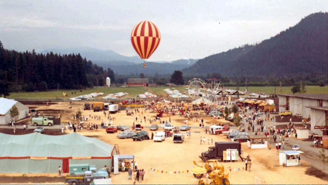
A circa mid-1960s photo of the first Semco balloon over a carnival at Seattle Skyport.
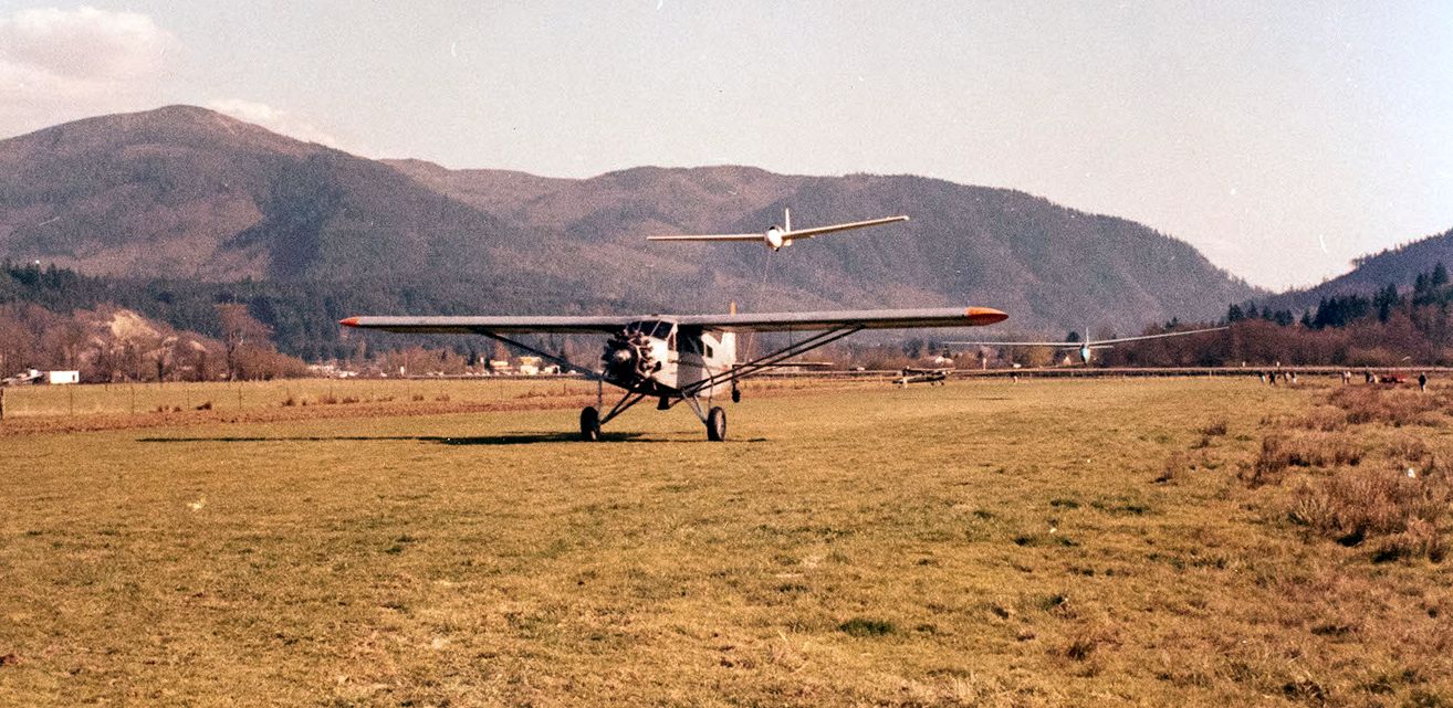
An undated photo of a Fairchild towing a glider at Seattle Skyport.

Seattle Skyport, as depicted on the 1965 USGS topo map.

The June 1965 Seattle Sectional Chart (courtesy of Ron Kunse) depicted Seattle Skyport as having a 2,000' unpaved runway.
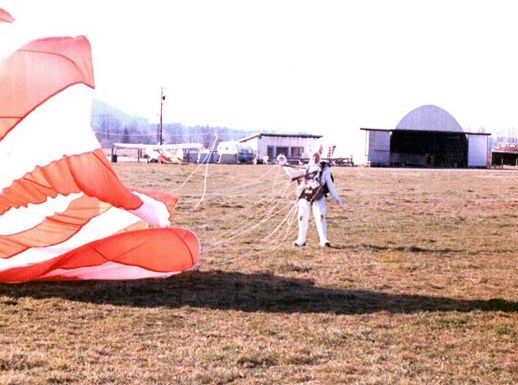
A circa 1967 photo of the Easter Bunny (Ed Thomas) after parachuting into Seattle Skyport.

A 9/3/68 USGS aerial view depicted Seattle Skyport as having a single grass northwest/southeast runway, with a few small buildings on the west side.

The December 1968 Seattle Sectional Chart depicted “Skyport” as having a 2,100' unpaved runway,
and indicated parachuting operations were conducted.
A 1968 aerial view depicted the Skyport in much the same configuration as the 1964 aerial photo.

A beautiful Spring or early Summer 1969 photo by Irv Bjorkheim of a Cessna 172 & 2 gliders at Issaquah.
Ken Sullivan recalled, “It was used as a staging area for gliders, and lots of skydiving, in addition to routine general aviation.
This was in the late 1960s, and I think into the 1970s.”
According to Nick Fowler, “It hosted both light aircraft & gliders -
and was said to be one of the busiest airports in the state on a good weekend.”
It was still depicted as “Skyport” on the 1974 USGS topo map.
According to www.historylink.org, “By the late 1970s, a boom in housing & commercial development in Issaquah began to encroach on the Skyport.
The Pickerings sold their property to a real estate company in 1975.
The new owners continued leasing the airfield to Emrich, but soon sought to terminate the lease,
touching off years of controversy & litigation over the site’s future.”

A February 1978 photo of an unidentified glider landing at the Issaquah Skyport.
A 1980 aerial view depicted the Skyport at perhaps the height of its usage,
with a total of 14 light aircraft seen parked around the west & south sides of the grass runway.
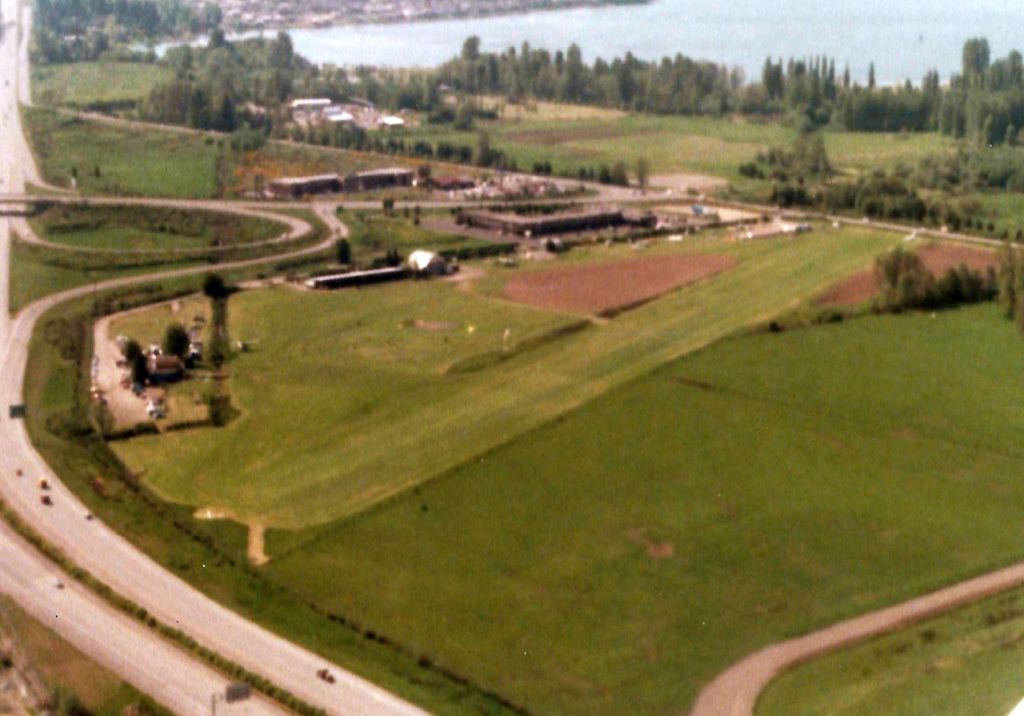
A circa 1981-83 aerial view looking northwest at Issaquah Skyport.

The January 1982 Seattle Sectional Chart (courtesy of Paul Columbus)
depicted Issaquah Skyport as a private airfield having an 1,800' unpaved runway.

The 1983 USGS topo map labeled Issaquah Skyport simply as “Landing Strip”, but depicted it as having a wide northwest/southeast runway,
with several taxiways & a few small buildings on the southwest side.

A 1982 photo by Richard Schweitzer of Bob Schweitzer in front of several gliders at Issaquah Skyport.
Bob recalled, “After high school, I would come down to Issaquah Skyport to learn to fly in the yellow Schweitzer 2-32.
Yes the shorts are too short, it was the 1980s, HA. The soaring school was at the northwest corner of the airfield.
They had both a school & a stunt pilot to take people up and scare them with aerobatics (the silver glider in the photo).
The highest I got to, in altitude, soaring, was 12,000'. I never knew how drafty the cockpit was until that day. So very cold at that altitude.”
Scott McKee reported, “I took my first flying lesson [at Isaquah Skyport] on 3/31/84.”

A 2/2/85 aerial view by Scott McKee looking northwest at a snowy Issaquah Skyport.
Scott McKee reported, “It suggests that the airport operated in all kinds of conditions! [Taken] from the cockpit of our Blanik L-13; Jeff Paul at the controls.”
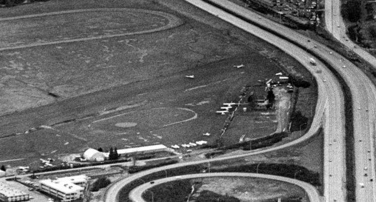
A 1985 aerial view looking east showed at least 8 light aircraft at Issaquah Skyport.

A 4/5/86 aerial view by jump master Mark Scott of an awkward first parachute jump by Scott McKee looking down at Issaquah Skyport.
Scott McKee reported, “At the south end of the runway [bottom of picture], a blue & yellow Schweitzer 2-33 waits for a tow from the Pawnee nearby.
On the ground beyond the jumper's right knee can be seen a surplus Piasecki helicopter on static display, an attraction popular with passing tourists.
Notice the whale-shaped swimming pool on the roof of the Holiday Inn [upper-left]? I'm told that jumpers landed there at least once.”
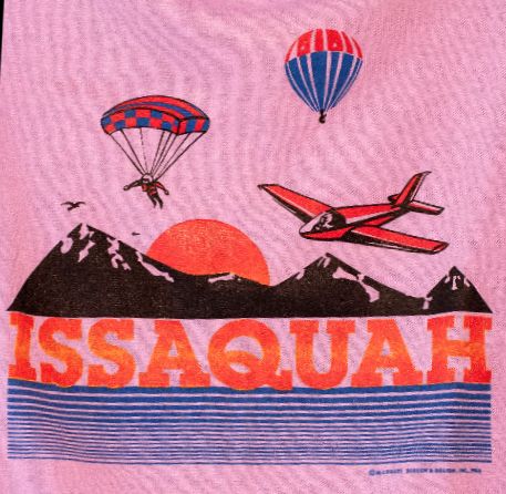
An undated Issaquah Skyport T-shirt.

The last aeronautical chart depiction which has been located of the Skyport was on the January 1987 Seattle Terminal Chart (courtesy of Mitchell Hymowitz).
It depicted “Skyport” as having a mere 1,800' unpaved runway, and indicated parachuting operations were conducted.

The last photo which has been located of the Issaquah Skyport was a 1987 photo of several light planes (courtesy of Owen Blauman).
Scott McKee reported, “I gave the last glider instruction offered at [Issaquah Skyport] on 7/7/87 -
one farewell Biennial Flight Review each for airport operator Linn Emrich & commercial pilot Paul Long.”
According to www.historylink.org, “The legal battle eventually reached the Washington Supreme Court,
which ruled in favor of the property owners, and in 1987 the Skyport’s lease came to an end.
That May, 55% of voters supported a $5.2 million bond issue for the public to buy the Skyport & keep it operating.
However, the bond issue needed 60% approval to pass.
The same month, following 2 years of debate, the Issaquah City Council approved a plan for a business park on the site.”
According to www.historylink.org, “The Skyport was to close on 6/30/87, but Jamey Woodward, the parachute center operator,
went to court, arguing that he had a verbal agreement with the developers to operate through the summer.
However, Woodward chose not to pursue the case, and agreed to vacate by 8am on 7/8/87.
Early that morning, Woodward piloted the plane for his 3 workers to make the final parachute jump,
then flew the final 2 planes off the field shortly before developers Lang Sligh & Dennis Scholl marked it closed.”
According to www.historylink.org, “On 7/8/87, three longtime workers at the Issaquah Skyport,
a center for sky sports for nearly 30 years, make one last early morning sky dive.
After years of controversy over the future of the airfield, located on the historic Pickering farm just north of Interstate 90,
its lease has expired, a bond issue to buy the property & keep the parachute & gliding center operating has narrowly failed,
and the Skyport is forced to make way for a shopping center development.
Shortly after Skyport operator Jamey Woodward flies the last 2 planes from the field ahead of an 8am eviction deadline,
developers Lang Sligh & Dennis Scholl mark large white X’s at each end of the runway, the international sign for a closed airfield.
The Pickering Place shopping center is subsequently built on the site.”
Steve Payne recalled, “I recall a great deal of controversy regarding its closure,
and I remember being sad as I used to love watching the activity as we headed home from points east as the field was located right along Interstate 90.”
According to Linn Emrich's obituary (courtesy of Tom Imrich), “When the area started to develop, the airport closed.
Emrich moved to Camano Island in 1988, shortly after losing the battle with developers to preserve Issaquah Skyport.
A Holiday Inn & Costco now stand in its place.”
A 1990 aerial photo showed new roads covered the Issaquah Skyport site in preparation for further redevelopment,
erasing any trace of the former little airport.
Scott McKee recalled, “Issaquah: It appeared in early versions of Microsoft Flight Simulator,
since it was the first airport east of Boeing Field, where action was likely to start - and also the first one south of Microsoft's Redmond campus.
One could still visit, digitally, long after the airport closed. By [the time of] Windows 95, it was gone.
A 1998 aerial photo showed a shopping center occupying the site of Issaquah Skyport,
according to Ken Sullivan, “a big shopping area, with Lowe's, Costco, etc.”
According to www.historylink.org, “The former Skyport is now (2003) the location of the Pickering Place shopping center.”

An 8/20/11 aerial view showed a shopping center covering the site of Issaquah Skyport.
The site of Issaquah Sky Park is located south of the intersection of Northwest Sammamish Road & 11th Avenue Northwest.
____________________________________________________
Cedar Grove Airpark, Cedar Grove, WA
47.45, -122.05 (Southeast of Seattle, WA)

A 1964 aerial view depicted Cedar Grove Airpark as having a single unpaved northeast/southwest runway.
Cedar Grove Airpark was apparently built at some point between 1936-64,
as it was not yet depicted on a 1936 aerial photo nor listed among active airfields in the 1963 WA Pilot's Guide (courtesy of Ron Dupas).
The earliest depiction which has been located of Cedar Grove Airpark was a 1964 aerial view.
It depicted the field as having a single unpaved northeast/southwest runway.
Several shed/hangars were located on the south side of the field.
There were not yet any aircraft visible on the field, so it might still have been under construction at that point.
Jim Spee wrote, “When an airport closes, its history often closes with it.
Cedar Grove Airpark in Maple Valley, Washington was on the aeronautical charts for just a short time, about 1967-82,
but it had a major role in the aviation lore of western Washington at time when it was a hub of sport aviation.
Cedar Grove Airpark started out as an airstrip on the site of the Queen City Farms pig ranch between Renton & Maple Valley.
The farm had shut down after a hog cholera epidemic in the 1950s. At the time, it was owned by Seattle Disposal Company.
Karl Spee, the founder, chief pilot, and president of Alpine Helicopters was flying a Bell 47 back to Issaquah Sky Ranch
from somewhere in the Cascade Mountains in the summer of 1966 when he spotted the airstrip where there wasn’t one on the map.
He landed & introduced himself to the caretaker, Wayne Yatelin. Wayne was a Caterpillar operator who lived on the property with his family.
He used his employer’s D-9 bulldozer to carve out the airstrip & built a hangar for his Cessna 195.
Karl got the contact information from Wayne & went to see Josie Razori, the president of Seattle Disposal.
Karl & Mr. Razori negotiated rent for half of the 300+ acre property for about $450/month, not including any of the residences.
He could modify the unused buildings as he saw fit but he was not to use the vehicles.”
Jim continued, “I first saw Cedar Grove Airpark during Christmas vacation of 1966.
A light snow had fallen & we took some old skis up to see if we could find a hill.
We drove out Maple Valley highway east of Renton for about 8 miles until we came to Cedar Grove Road.
We got in line behind the garbage trucks headed up the hill to the County Landfill.
Just before their turn, we found a narrow dirt road that climbed west through an alder forest & came out on a plateau about 480' above sea level.
The road was the bumpiest I had ever seen with ridges, washboards & potholes the whole way. If it had not snowed, we would have been buried in dust.
At the top of the hill we came to a gate with a welcoming 'Keep out' sign. Next to the gate was a rundown house.
A little further up was the caretaker's place with the ramshackle hangar for his Cessna 195. We turned a corner & drove along a narrow feed barn with a low roof.
'Those will open up into hangars', Karl told me. At the end of the barn was another building, perpendicular to the long one.
'The shop will go there.' The only hill we found was a gentle slope down to the bottom of a small gravel pit.
Just beyond the gravel pit was a large empty field. When the snow melted, we would learn that it was covered with the bones of hundreds of pigs, culled during the cholera epidemic.
I strapped on some short skis & tried to ski down the slope into the gravel pit, but it the snow was sticky & the slope was too gradual.”
Jim continued, “The airport became my home away from home. I spent endless Saturdays there exploring acres of wilderness & deserted buildings.
The old boiler building looked like something out of a James Bond movie. Seattle Disposal had collected food waste from Seattle restaurants & cooked it there to feed the pigs.
The water tank at the top of the hill that supplied the whole property was filled from a well down by Cedar Grove Road.
It had a float switch at the top that shut off the pump when it was full. Another float rode between 2 rails on the inside of the tank.
It was connected by a pulley to a counterweight that slid up & down between 2 rails on the outside of the tank.
The rails were marked so you could tell how much water was in the tank. Water flowed back down the hill to outlets around the property where water could be directed to the various barns.
The pipes came up through big square openings that were covered with rotten timbers.
It was great fun to crawl down the metal rungs & see who was brave enough to get to the bottom of the dark chasm, which was probably all of 10' deep & about 4' by 4' across.
To a bunch of young boys, it was a treasure trove. Between the barns & scattered around the property were old cars, trucks, tractors, and equipment belonging to Seattle Disposal that no longer ran.
We had a lot of fun sitting in them & pretending they still worked.”
Cedar Grove Airpark was not yet depicted on the 1967 Seattle Sectional Chart or the 1968 USGS topo map.
A 1968 aerial view showed 6 light aircraft parked at Cedar Grove.

The earliest aeronautical chart depiction which has been located of Cedar Grove Airpark
was on the December 1968 Seattle Sectional Chart (courtesy of Chris Kennedy).
It depicted Cedar Grove as a public-use airport having a 3,000' unpaved runway.

A 1970 aerial view looking north (courtesy of Jim Spee) depicted Cedar Grove as having an east/west unpaved runway.
Jim Spee recalled, “Karl hired a 16-year old boy from Des Moines named Steve Goodman who was willing to work for flying time.
Steve would come out every Saturday. He started by helping Karl build a barbed wire fence to keep cows & horses that lived on the old farm off the runway.
The ground was glacial moraine made up of fist size rocks & sand.
A post hole digger wouldn’t work, it just bounced off the rocks, so Steve had to use a metal rod to dislodge them & shovel them out one at a time.
It was back-breaking work, but he wanted to fly, so he put in the hours & eventually worked his way up to a commercial pilot’s license.
Steve shoveled gravel out of the feed barn & wheel-barreled onto the road to create the taxiway. This was before the days of Bobcat loaders.
Once the barns were clear, they started opening up the sides of the barns & knocking out the 3' tall subwalls.
They used old lumber from the other barns to shore up the openings with laminated beams so the roof would not cave in.
Once they were ready, Karl rented the hangars out for $30-$50/month.
His wife, Ricarda Spee, kept track of the rentals using an old ledger from New Paris Dry Cleaning, the business Karl’s father had in the 1940s.
Instead of shirts, pants, skirts, and coats, she wrote in the hangar number, the renters’ contact information & the months of the year so she could mark off when they paid.”
Jim continued, “Karl & his crew built 3 shops on the west end of the airport.
The first one was for helicopters & later became the paint shop, the second was for trucks, and a third for airplanes & helicopters. Each one got a little better equipped.
The main shop eventually had a loading dock with tracks out front that matched the helicopter skids.
The helicopters would land on the track & could be wheeled under the overhanging roof of the shop.
They rigged up a hoist on an I-beam that ran the length of the shop then out over the loading dock.
Using the hoist, the mechanics could lift the entire helicopter to switch from skids to floats.
They could also lift just the rotor & roll it into the shop for balancing or switching out components at the end of their fatigue limit.”

A circa 1970s photo by Jim Spee looking northeast at the Cedar Grove Paint Shop. The small barn to the left was the truck shop.
Jim Spee recalled, “Another row of barns faced the runway. Two of the barns were joined together to form 3 large hangars.
One of Dad's tenants, Mr. MacDowell, was an unemployed carpenter. Karl hired him to build the addition, trading rent for work.
His workmanship was quite good, but he had a pretty bad temper. They built a small tackle shed to hold all the rigging for external loads.
Karl added a line of cable northeast of the barns & used it to tie down his growing fleet of fixed-wing airplanes.
The Chevron distributor sold him a couple of old fuel pumps & a tank so he could sell fuel. He built a pump house to store bulk oil & empty barrels.

A circa 1970s photo by Jim Spee looking west from mid-runway of Cedar Grove at a Bell 47 hovering above a Cessna 172.

A circa 1970s photo by Jim Spee looking south from mid-runway of Cedar Grove at 2 Bell 47 helicopters.
Jim Spee recalled, “The gravel runway at Cedar Grove was pretty intimidating to a lot of local pilots.
They always referred to it as the 'Hog ranch' despite Dad's efforts to market the Cedar Grove name.
Takeoff was usually to the southwest. You aimed the nose of the airplane at the silver roof of the barn on the hill across the valley & poured on the gas.
If you were lucky, you didn't ding your prop on any rocks as you accelerated. Once airborne, the hill dropped away to the Stoneway gravel pit & you turned left over the woods.
Downwind, it was easy to keep the runway in sight. Karl put a windsock at the halfway point, where you put on carb heat.
Even with the end of the runway, you would cut power & start to turn.
The high-tension power lines crossed the northeast end of the runway at the top of a pretty steep slope, so you had to get past those before you could drop too low.
A last-minute sideslip would drop you in over the 2 oil pits. When you got to them, it was time to level off & aim for the narrow strip of runway at the northeast end.
After the first 200' or so, it widened out a little bit. Eventually, Karl hired an earthmover to scrape off a much wider strip in front of the hangars & planted it with some grass.
The grass had a hard time growing in the rocky glacial till. Our Saturday job for several years was to clear off the biggest of the rocks.
I didn't mind too much but my older brother hated this chore & did not like going the airport much as a result (although he later wound up living there!).”

A 1970 aerial view looking northwest (courtesy of Jim Spee) depicted Cedar Grove as having an east/west unpaved runway.
Jim continued, “Alpine Helicopters continued to grow although it did not exactly thrive.
The company eventually acquired over 12 Bell 47 s, 2 Hughes 500s, a Hiller 1100, a Piper Aztec, 2 Cessna 172s, 2 Cessna 150s, and 2 Aeronca Champions.
Karl pioneered the use of helicopters to carry canceled checks across Puget Sound to computer processing centers in Burien, Northgate, and downtown Seattle.
He also used the Aztek to carry canceled checks across the Cascades from banks in several small Eastern Washington towns such as Yakima, Prosser, Walla Walla & Moses Lake.
These were great contracts for keeping pilots employed, but Alpine was no Federal Express. It was under-capitalized & maintenance on the aging fleet was a constant struggle.”

A circa 1970s photo by Jim Spee of Aeronca 7BCM N81724 belonging to Alpine Helicopters taking off from Cedar Grove.

The earliest topo map depiction which has been located of Cedar Grove Airport was on the 1973 USGS topo map.
It depicted Cedar Grove Airport as having a single northeast/southwest runway with a row of buildings along the southwest side.
Jim Spee recalled, “In June 1974, Karl & his oldest son were in a head-on collision with a truck.
He was rushed to Harborview Hospital in Seattle & stayed unconscious until September.
While his wife & employees were able to keep the business going over the summer while he was hospitalized,
his traumatic brain injury meant that he could no longer fly or run the business the way he had before.
Fuel prices skyrocketed & business was slow.”

The January 1977 Seattle Terminal Area Chart (courtesy of Chris Kennedy)
depicted Cedar Grove as a public-use airport having a 1,900' unpaved runway.
Note that it had lost almost half of its runway length in only 9 years.

An 8/17/77 USGS aerial view depicted 6 light single-engine aircraft & 1 helicopter parked on the southwest side of Cedar Grove Airport.
James Foster recalled, “I learned to fly out of Cedar Grove Airport starting in 1979.
I was renting an old Cessna 150 for $12/hour! I miss the old days.”

The 1980 USGS topo map depicted a single northeast/southwest runway, labeled simply as “Landing Strip”.
It also depicted the adjacent Gravel Pit to the west, which would eventually consume the little airport.
A 1980 aerial view depicted a total of 14 light aircraft parked at Cedar Grove Airpark.
The January 1982 Seattle Sectional Chart (courtesy of Paul Columbus) depicted Cedar Grove as having an 1,800' unpaved runway.

Two circa 1982-83 photos by Dan Plute of an Advanced Aviation Cobra ultralight at Cedar Grove Airpark.
Several hangars are visible in the background.
Dan Plute recalled, “I learned to fly in the early 1980s
and the airport was in poor repair with perhaps 12-15 airplanes hangared or tied down at the time.
There was a fellow with a casting operation in the southern-most portion of the complex
that was making rudder-pedals for experimental [aircraft],
and the northern-most 'hangar' had been rented to Stoddard-Hamilton Aircraft (we had been told)
so it may well have been the birth place of the Glasair aircraft.
A fellow by the name of Don Summers & I had that hangar
and operated an ultralight [aircraft] sales operation known as Pacific-Ultracraft for a short time.”
Dan Plute recalled, “Evidently gravel is more valuable than airport revenue
as the area was mined for the gravel to the point where the runway was too short for anything other than ultralight operations.”

A circa 1982-83 photo by Don Summers of Dan Plute in an Advanced Aviation Cobra ultralight at Cedar Grove Airpark,
with a Republic SeaBee visible in the background.

An undated aerial view looking north at Cedar Grove Airpark from the 1983 Washington State Pilots Guide (courtesy of Dan Plute).
It described Cedar Grove as a commercial airport having a 2,500' grass & gravel Runway 6/24 (with a 500' overrun),
and it listed the manager as Paul Hoffman.

The last depiction which has been located of Cedar Grove Airpark was on the 1983 USGS topo map.
Jim Spee recalled, “While he had some interesting tenants, including the founder of Glasair, Tom Hamilton, who built their prototype in one of the shops,
the airport was not making enough money to pay the rent & by the early 1980s, Karl had to close the business & give it up.
Seattle Disposal ran it for a short time before accepting an offer from the Stoneway company to sell the gravel. By the mid-1980s, the buildings & runway were gone.”
According to Dan Plute, “Cedar Grove Airpark was closed sometime around 1985.
Eventually in about 1985 or 1986 the buildings came down.
So many airports have disappeared that I fear for future generations of general aviation pilots.
Soon there will be nothing left!”

Cedar Grove Airpark was still depicted on the January 1987 Seattle Terminal Chart (courtesy of Mitchell Hymowitz),
even though it had reportedly been closed for roughly 2 years by that point.
In the 1990 USGS aerial photo, a gravel pit had covered the site of Cedar Grove Airpark, with all traces of the former airport having been scraped away.
Dan Plute reported in 2007, “Currently Cedar Grove Composting occupies the site.”

In a 2017 aerial photo, the composting operation covered the property, with not a trace remaining of Cedar Grove Airpark.
Jim Spee reported, “As of 2018, the property is occupied by Cedar Grove Composting.
Their Youtube Channel says “Providing Waste Management Solutions to the Pacific Northwest since 1938”
which suggests that it is the descendant of the original Seattle Disposal, so the property has come full circle from using food scraps to produce pork, to creating high grade compost from green waste.
In between, a small aviation business thrived there, providing employment & the inspiration of flight to hundreds of people.”
The site of Cedar Grove Airpark is located north of the intersection of Cedar Grove Avenue Southeast & 217th Avenue Southeast.
____________________________________________________
Bellevue Airfield (BVU), Bellevue, WA
47.58, -122.13 (Northeast of Renton, WA)

A circa 1945 aerial view looking west at Bellevue Airport (courtesy of Owen Blauman) while under construction.
According to the Seattle times, Arthur Nordoff founded the Bellevue Airfield in 1941, but because of the war it didn't open until 1945.
Nordoff had been an Army aviator during WW1, and his daughter, Nancy Dunnam, flew in the Women's Air Corps during WW2.
Bellevue Airport was not yet depicted on the 1945 Seattle Sectional Chart.
Bellevue Airfield was a 160 acre property.
Its neighbors included a gun club, a turkey ranch, a mink farm, and a garbage dump at the north end of the field.
The earliest depiction which has been located of Bellevue Airport was a circa 1945 aerial view looking west (courtesy of Owen Blauman).
Owen Blauman reported, it was “one of the first pictures of the Bellevue Airport when it was under construction.”
It depicted the field as having a single asphalt northeast/southwest runway.

The earliest aeronautical chart depiction which has been located of Bellevue Airport
was on the October 1948 Seattle Sectional Chart (courtesy of Chris Kennedy).
It depicted the field as having a 2,300' hard-surface runway.

Bellevue Airport was depicted by the 10/12/59 FAA Inspection Report (courtesy of David Field)
as having a single 2,256' asphalt northeast/southwest runway
with a parallel taxiway on the northwest side.
An office building & several hangars were depicted on the southeast side of the field.
The operator was listed as Puget Sound Air Service, and the managers were listed as J.J. Dunnam & A.E. Nordhoff.
A total of 82 aircraft were said to be based at the field.
The 1962 AOPA Airport Directory described the field as having a single 2,250' asphalt Runway 1/19,
and listed the operator as Sound Air Service, Inc.
The 1963 WA Airport Directory (courtesy of Ron Dupas)
depicted Bellevue Airport as having a single 2,256' blacktop northeast/southwest runway
with a parallel taxiway on the northwest side.
An office & several hangars were depicted on the south side of the field.

An undated aerial view looking east at Bellevue Airport from an airport brochure received in 1963 by Martin Snyder.
The brochure described the field as having a single 2,250' asphalt Runway 2/20,
and the photo depicted a large number of T-hangars on the southeast side of the field,
along with a colorful assortment of 17 light aircraft.
Martin recalled, “In July 1963 I flew a Cessna 182 from the Van Nuys (California) to Bellevue to visit with my daughter.
I had all of 164.6 hours flying time so this long cross country trip was a big thrill.”
A 1964 aerial photo depicted Bellevue as a very well-used little airport,
with several dozen light planes parked around numerous hangars along both sides of the single runway.
The June 1965 Seattle Sectional Chart (courtesy of Ron Kunse)
depicted Bellevue Airfield as having a 2,200' paved northeast/southwest runway.
Peter Gatehouse recalled, “In 1965-67 I had a friend with whom I shared a Mooney 20C.
He lived in Bellevue, and through him, I came to know of the field [Bellevue Airport];
on one occasion there was a Vultee BT-13 parked there. ”
The 1967 Seattle Sectional Chart (courtesy of John Voss) depicted Bellevue as having a 2,200' unpaved runway.

A 1068 photo of a Cessna 152 overflying other aircraft & the Bellevue Airport fuel pumps.

A 9/2/68 USGS aerial view showed Bellevue to be a very popular general aviation airport, with several dozen light aircraft parked on the field.

The December 1968 Seattle Sectional Chart (courtesy of Chris Kennedy)
depicted Bellevue as having a 2,100' unpaved runway.
Arthur Nordoff (son of the founder of Bellevue Airport) recalled,
"We never had a control tower, but we had runway lights that operated until 11 at night."
Business often picked up during winter months when fog socked in Renton & Boeing Fields, he said.
"Once when The Beatles were coming to town, teenagers heard a rumor they weren't going to land at Sea-Tac or Boeing," Nordoff said.
"So for an afternoon we had a bunch of giggling teenagers around.
Of course The Beatles didn't come to Bellevue."
Through the 1960s & 1970s flight training was conducted at Bellevue Airfield by Seattle Flight,
which also had facilities at Boeing Field, Everett-Paine Field, and Auburn Airport.
Seattle Flight eventually grew to become the largest flight school in the Pacific Northwest, with a fleet of over 40 Piper aircraft.
Ken Walker recalled, “As a teenager I went past the airport once & there had just been an accident.
There is a grocery store about a ¼ mile west of the end of Runway 2 and somehow, either a power failure or weather,
someone in a Cessna had managed to pilot his plane right through the front door of the store.
I don’t remember if there were any injuries
but it sure looked funny seeing the back end of a Cessna sticking out the doorway of the store.”

An aerial view looking north at Bellevue Airport from the 1971 WA Airport directory (courtesy of Chris Kennedy).
By the early 1970s, Bellevue was a very busy little airport, with a total of 51,000 takeoffs & landings per year.

The July 1974 Seattle Terminal Chart depicted Bellevue as having a 2,300' paved runway.

A circa 1970s photo (courtesy of David Field) looking northeast along Bellevue's Runway 2.

A circa 1979 aerial view by James Foster on final approach for Bellevue's Runway 2.
According to David Field, “In approximately 1979, the property was acquired by Cabot, Cabot & Forbes, a property development company.
They left the airport open for a few years but cut back the service until eventually there was no service or fuel available.”

As seen in a 1980 aerial view, Bellevue was a very well-used airport right up to the very end,
with a total of over 75 light aircraft visible parked on the field.

A circa 1980s photo by Dennis Peterson of his Ercoupe at Bellevue.
Dennis observed, the “Pre-overhaul paint scheme was dirty canary yellow.”

The last photo which has been located showing Bellevue Airport in operation was a circa 1980s photo of Dennis Peterson taxing back into Bellevue in his Ercoupe.
Dennis recalled, “It was a great little airfield & the regulars that hung out there on a daily basis were good friends.”
The 1982 AOPA Airport Directory (courtesy of Ed Drury) described Bellevue as having a single 2,325' asphalt Runway 20/20,
and listed the operators as Bellevue Aviation & Eagle Aircraft Service.
Unfortunately, the rapid development of the surrounding Bellevue area meant that the end was in sight for this little field.
The 1982 AOPA Airport Directory included the note, "Possibility for airport closing spring of '82."
The last aeronautical chart depiction which has been located of Bellevue Airport
was on the January 1982 Seattle Sectional Chart (courtesy of Paul Columbus).
It depicted Bellevue as having a 2,300' paved runway.

Bellevue Airfield was still shown on the 1983 USGS topo map,
which depicted the runway as having a parallel taxiway, and at least 2 hangars situated southeast of the runway.
Bellevue Airport was closed in 1983.

A sad sight for the aviation community – a public notice for the 5/21/83 auction of the Bellevue Airfield buildings.

A 1985 aerial view showed the majority of the Bellevue Airfield runway remained intact, but the hangars had been removed,
and an office building had been built at some point between 1980-85 on the southwest runway end.
Bellevue Airport was depicted as an abandoned airfield on the July 1985 Seattle Terminal Aeronautical Chart (courtesy of Stu Sibitzky).
According to David Field, “Cabot, Cabot & Forbes developed the site with office buildings & hotels.
Some of the property was acquired by the Boeing Company.
For several years they had their computer facilities headquartered there.”

A 1990 USGS aerial view looking north showed that Bellevue Airfield was long gone, as a complex of several office buildings had been built on the site.
However, several lengths of the former runway & its parallel taxiway were still plainly recognizable, just north of the new parking lots.

A circa 2002-2005 aerial view looking west at the northern end of the former Bellevue Airport property
shows that a small segment of the northern end of the runway pavement remained intact.
Ironically, some aviation use of the site lived on, as a new heliport sat just north of the end of the former runway.
It was listed as of 2006 as the “Bellevue Business Park Boeing Company Services Headquarters Heliport” (71WA).

A 2010 photo by Bob Schweitzer of the remnants of the helipad at the site of Bellevue Airport.
Bob reported, “A recent Microsoft building has gone up at the former end of the runway.
The only remaining part of any aviation use is the pad for the heliport but it is out of service too.”

A 2015 aerial view showed that the site of Bellevue Airfield was no longer recognizable as a former airport,
with the only tiny remaining piece of runway pavement remaining being a small section (reused for a short while as a heliport) at the top-right now relegated to serving as a basketball half-court.
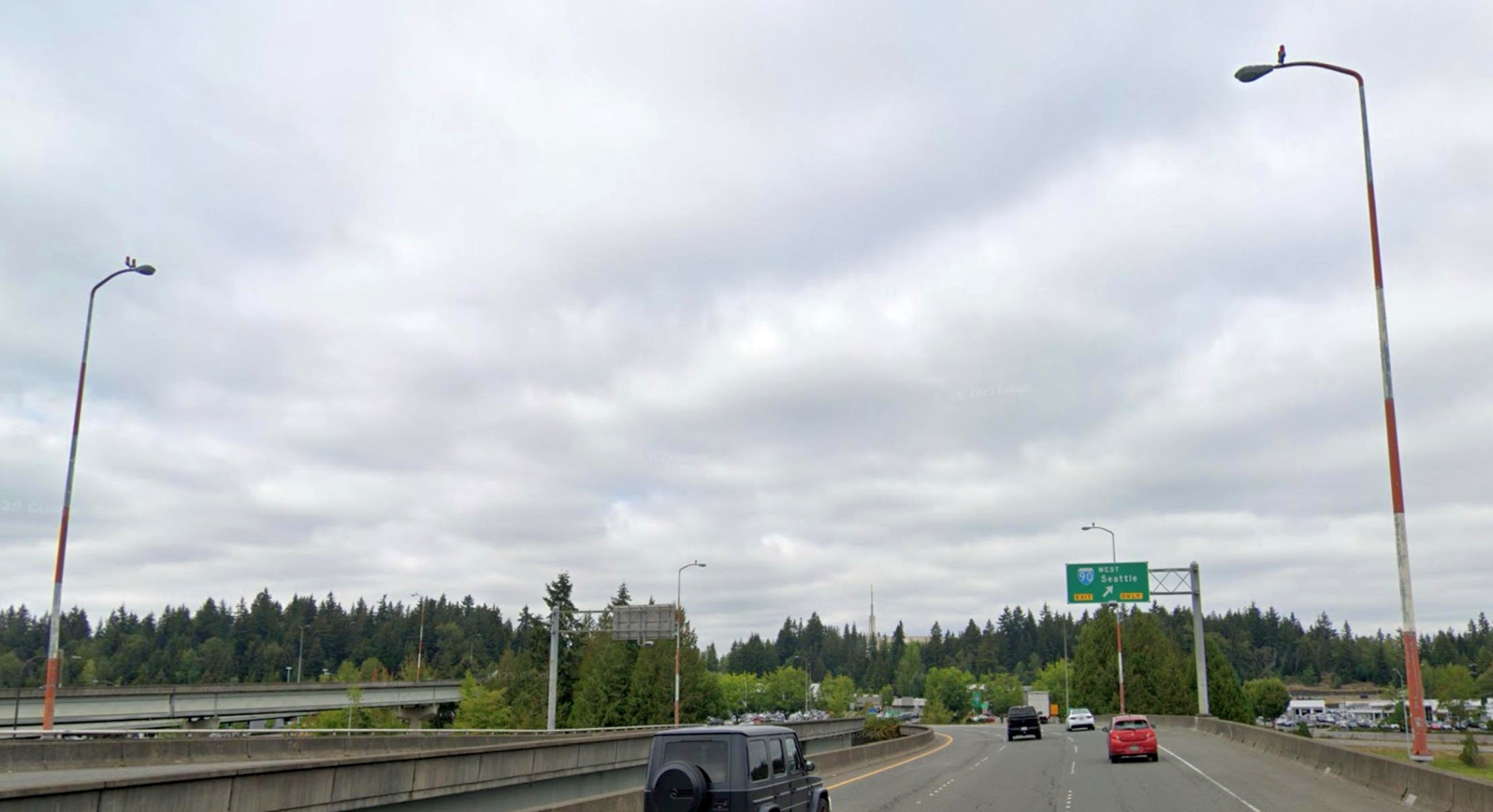
A 2025 photo by James Simms of an odd trace which remains more than 4 decades after Bellevue Airport's closure: aircraft obstacle lights on top of red & white poles at the adjacent I-90 interchange,.
The site of Bellevue Airfield is located north of the intersection of Southeast Eastgate Way & 158th Avenue Southeast, just north of Interstate 90.
____________________________________________________
Or if you prefer to contact me directly concerning a contribution (for a mailing address to send a check),
please contact me at: paulandterryfreeman@gmail.com
If you enjoy this web site, please support it with a financial contribution.
____________________________________________________
This site covers airfields in all 50 states.