
Abandoned & Little-Known Airfields:
Washington: Northern Seattle area
© 2002, © 2026 by Paul Freeman. Revised 7/1/26.
This site covers airfields in all 50 states: Click here for the site's main menu.
____________________________________________________
Please consider a financial contribution to support the continued growth & operation of this site.
(Original) Everett Airport / Ebey Island Airport (revised 7/1/26) - Martha Lake Airport (revised 8/31/25) - North Seattle Air Park (revised 1/11/20)
Seattle NAS / Sand Point NAS (revised 10/30/25) - Sky Harbor Airport (revised 9/1/24)
____________________________________________________
Sky Harbor Airport (S86), Sultan, WA
47.871, -121.793 (Northeast of Seattle, WA)
Sky Harbor Airport, as depicted on the October 1962 Seattle Sectional Chart.
This small grassroots airport was evidently established at some point between 1952-62,
as a 1952 aerial photo just showed forested vacant land
and it was not yet depicted on the April 1957 Seattle Sectional Chart.
The earliest depiction which has been located of Sky Harbor Airport was on the October 1962 Seattle Sectional Chart.
It depicted Sky Harbor as having a 2,000' unpaved runway.

The 1968 USGS topo map depicted Sky Harbor Airport as an unpaved east/west runway, labeled generically as “Landing Strip”,
with 2 small buildings along the south side.

The earliest photo which has been located of Sky Harbor Airport was a 9/2/68 USGS aerial view.
It depicted a single east/west unpaved runway, with a few small buildings on the south side.

The January 1990 Seattle Terminal Aeronautical Chart depicted Sky Harbor Airport as having a 1,900' unpaved runway.

The only photo which has been located showing an aircraft at Sky Harbor Airport was a 1991 USGS aerial view looking northwest.
It depicted Sky Harbor as having an east/west unpaved runway, with a few small buildings & 1 single-engine light aircraft along the south side.

The 1997 USGS topo map depicted Sky Harbor Airport as an unpaved east/west runway, still labeled generically as “Landing Strip”,
with 3 small buildings along the south side.

The last aeronautical chart depiction which has been located of Sky Harbor Airport was on the May 2017 Seattle Terminal Chart.
It depicted Sky Harbor as having a 1,900' unpaved runway.

The last photo which has been located showing Sky Harbor Airport still intact was a 2017 aerial view looking northwest.
The runway & hangar remained intact, but sadly there were no aircraft visible on the field.
According to Bob Bogash, Sky Harbor Airport “closed in approximately summer 2018.”

A sad sight for anyone who appreciates grassroots aviation: a 2018 aerial view looking northwest showed Sky Harbor's hangar removed,
and the property being redeveloped presumably for ever more houses.
Thanks to Bob Bogash for pointing out this airfield.
____________________________________________________
(Original) Everett Airport / Ebey Island Airport, Everett, WA
48.035, -122.18 (Northeast of Seattle, WA)

A 7/26/27 photo (courtesy of Arleigh Movitz) of an Eagle Rock biplane (model undetermined) of Commercial Air Transport Inc. with its crew at the original Everett Airport.
The original airport for the town of Everett was located northeast of the town, on a narrow sliver of land on Ebey Island.
The date of establishment of the original Everett Airport has not been determined.
The earliest depiction which has been located of Everett Airport
was a 7/26/27 photo (courtesy of Arleigh Movitz) of an Eagle Rock biplane (model undetermined) of Commercial Air Transport Inc. with its crew.
It depicted a grass field without any other improvements.

A 4/22/28 photo (courtesy of Arleigh Movitz) of a large crowd attending the dedication of the Ebey Island Airport,
with a row of biplanes in front of a wooden hangar

A circa 1928 photo (courtesy of Arleigh Movitz) of a Ryan B-1 Brougham of Commercial Air Transport Inc. at Ebey Island Airport.

The earliest aerial photo which has been located of Everett Airport was a circa 1928 aerial view (courtesy of Arleigh Movitz) looking west,
which depicted an east/west grass runway on the north side of the island & a hangar on the west end.

A circa 1928 aerial view (courtesy of Arleigh Movitz) looking west at a high-wing monoplane overflying Ebey Island Airport,
showing a biplane parked in front of a hangar on the west side of the grass runways, and another 2 small buildings.

The earliest aeronautical chart depiction which has been located of Everett Airport was on the 1933 Seattle Airway Chart.
It depicted Everett as an auxiliary airfield.

The September 1936 Bellingham Sectional Chart depicted Everett as an auxiliary airfield.
A 1938 aerial view depicted 2 light single-engine planes parked next to the hangar at the original Everett Airport.

The last photo which has been located of the original Everett Airport was a 7/9/41 USGS aerial view.
It depicted Everett Airport as having an east/west grass runway on the north side of the island & a hangar on the west end.
The 1943 USGS topo map depicted 2 buildings on the west side of the Everett Airport site,
but it did not depict the runway or label the airport.
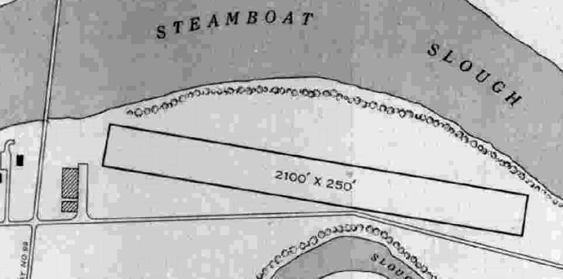
The 1945 AAF Airfield Directory (courtesy of Scott Murdock) described Everett Airport as a 30 acre property having a single 2,100' east/west sod runway.
It was shown to have 2 hangars on the southwest side, to be owned by the City of Everett, but to not be in operation.

The last aeronautical chart depiction which has been located of the original Everett Airport was on the April 1949 Bellingham Sectional Chart.
It depicted Everett as having a 2,100' unpaved runway.
The original Everett Airport was evidently closed at some point between 1949-50,
as it was no longer depicted on the April 1950 Bellingham Sectional Chart.
It had evidently been replaced by the much larger Paine Field a few miles to the southwest,
which had been released by the military & made available for civilian use.
A 1952 aerial view showed the hangar remained standing at the site of the original Everett Airport.
A 1954 aerial view showed the hangar had been removed at some point between 1952-54, but one airport building remained standing.
A 1969 aerial view showed no traces remaining of the original Everett Airport,
with the last building having been removed at some point between 1954-69, and Route 529 having been built through the property.

A 2017 aerial view of the site of the original Everett Airport, overlaid by John Clark to show the location of the runway, taxiway, hangar, and office building.
John noted, “The building foundations are clearly visible to this day with distinctive foliage that does not match the surrounding area.”
Thanks to Arleigh Movitz for pointing out this airfield.
____________________________________________________
North Seattle Air Park, Kirkland, WA
47.73, -122.24 (Northeast of Seattle, WA)

North Seattle Air Park, as depicted on the October 1947 Seattle Sectional Chart.
North Seattle Air Park was evidently established in 1947, as it was not yet depicted on the April 1947 Seattle Sectional Chart.
The earliest depiction which has been located of North Seattle Air Park was on the October 1947 Seattle Sectional Chart.
It depicted North Seattle as having a 2,200' unpaved runway.
According to “Kenmore by the Lake: A Community History” by Mathew Martin, this small general aviation airport,
North Seattle Airpark, was co-owned by Al Menard, and was located on the hill East of Juanita Drive near NE 141st Street.
It provided flight training for would-be fliers through the GI Bill.
The earliest photo which has been located of North Seattle Air Park was a 1948 photo,
which showed 8 single-engine aircraft parked near a small office building.

The 1950 USGS topo map depicted North Seattle Air Park as having a northwest/southeast runway with a few small buildings along the west side.

An undated photo (courtesy of Ed Millman) of Merritt Smythe & Joe Menard in front of 2 Cessna 140s at North Seattle Air Park from “Kenmore by the Lake: A Community History” by Mathew Martin.
Menard was the son of Airpark co-owner Al Menard.
John Pollock recalled, “As a teen following WWII, I personally took rides out of a field atop Finn Hill, east of Juanita Drive at Northeast 145th Street.
I recall this as a north/south grass strip operated by some WWII veterans. I Only had one flight there.”

A 7/1/52 USGS aerial view depicted North Seattle Air Park as having a northwest/southeast runway,
with several small buildings & over a dozen light aircraft on the west side.
According to “Kenmore by the Lake: A Community History” by Mathew Martin,
North Seattle Airpark lasted for a mere 4 years, ceasing operation in 1952.
However it continued to be depicted on aeronautical charts for another 2 years.

The last depiction which has been located of North Seattle Air Park was on the October 1954 Seattle Sectional Chart.
It depicted North Seattle as having a 2,200' paved runway.
North Seattle Air Park was no longer depicted on the April 1955 Seattle Sectional Chart.
A 1964 USGS aerial photo showed the north half of the North Seattle Air Park property had been covered with new houses,
although the southern half of the runway still remained, along with some of the hangars.
North Seattle Air Park was still depicted on the 1967 USGS topo map,
even though it had evidently been closed by over a decade by that point.
A 1968 USGS aerial view showed that a shorter portion of the North Seattle runway still remained, along with at least one small airport building.
But a shopping center had been built over the southern portion of the airport site.
The 1969 USGS topo map depicted streets crossing the site of North Seattle Air Park.
Amazingly a 1990 USGS aerial view showed that one small former North Seattle Air Park building remained standing,
just northeast of the intersection of Juanita Drive & 141st Place.

A 7/5/12 aerial view did not appears to show any remaining trace of North Seattle Air Park.
However, according to Bob Gerrish, “Actually, there are still one or two [former airport buildings] left that are being used as a daycare”, on the northwest side of the site.
The site of North Seattle Air Park is located northeast of the intersection of Juanita Drive & Northeast 141st Street.
____________________________________________________
Martha Lake Airport (S13), Alderwood Manor, WA
47.86, -122.24 (North of Seattle, WA)

Martha Lake Airport, as depicted on the October 1962 Seattle Sectional Chart (courtesy of Steve Martin).
According to an article in the 9/18/10 issue of the Everett Herald, “The Hauter family moved to the farm in 1953.”
Martha Lake Airport was not yet depicted on a 1956 USGS aerial photo (courtesy of Dallam Oliver-Lee).
According to an article in the 9/18/10 issue of the Everett Herald,
“Five years later [1958], Ed Hauter, Sr., bought his Cessna as the family was cobbling together land parcels for their airport.
A barn their dad built was transformed into offices & classrooms for flight training.
The fuel pump was nearby. Hangars could fit 30 aircraft, with tie-down spots for 50 more.
Herbert & her older brother, Ed Hauter, Jr., of Lynnwood, remembered cutting lots of grass with push mowers.
They also fueled & washed airplanes. Things were especially busy on nice, weekend days.”
“My parents worked very hard, and there were always customers around,” said Herbert.
“The whole family life revolved around the airport. We didn't take a lot of vacations because you always had to be running the airport.”
Martha Lake Airport was not yet depicted on the October 1960 Seattle Sectional Chart.
Martha Lake Airport was not yet depicted on the 1962 USGS topo map (courtesy of Dallam Oliver-Lee).
The earliest depiction which has been located of Martha Lake Airport was on the October 1962 Seattle Sectional Chart (courtesy of Steve Martin),
which depicted it as having a mere 1,700' unpaved runway.
The earliest directory reference to Martha Lake Airport which has been located is the 1962 AOPA Airport Directory,
which described the field as having a single 1,700' sod Runway 16/34.

The 1963 WA Airport Directory (courtesy of Ron Dupas) described Martha Lake as a private airfield,
with a single 1,700' sod north/south runway.
A row of T-hangars were depicted on the northeast side of the field,
as well as 2 other buildings (hangars?) east of the runway.
Larry Kohrdt recalled, “I grew up in the area & often walked through the airport property to access Martha Lake.
The runway was paved in 1964.
A mobile home park at the southwest end of the runway was constructed also in the early 1960s that just continued to grow.
Residential homes increased on all sides of the field as well as the outskirts of the lake.”
According to an article in the 9/18/10 issue of the Everett Herald,
During the 1960s, small housing developments sprang up nearby - one house only about 300 feet from the runway.”
“They were concerned about noise, the typical things,” Ed Hauter Jr. said.
According to an article in the 9/18/10 issue of the Everett Herald,
“The airport didn't bring in much money & the family battled the assessor over taxes.”

The Aerodromes table on the 1967 Seattle Sectional Chart (courtesy of John Voss)
described Martha Lake Airport as having a single 1,700' asphalt & concrete runway.
Jim Grant recalled, “In 1968 on a local solo flight I returned to Harvey's to find it covered over by a large cumulonimbus thunderstorm with heavy rainfall.
I decided to fly to Martha Lake to sit it out. This was before my cross-country work & my instructor was impressed with me making the mid-field turnoff on the runway.
The good people at Martha Lake gave me a hand-prop for my return to Harvey's.”

The earliest photo which has been located of Martha Lake Airport was a 9/4/68 USGS aerial view (courtesy of Dallam Oliver-Lee),
which showed a north/south runway, with 2 rows of T-hangars & a dozen light aircraft at the northeast end.

A 1970 photo showed airport founder Ed Hauter at Martha Lake Airport in front of a Cessna 170.

An aerial view looking west at Martha Lake Airport,
from the 1971 WA Airport directory (courtesy of Chris Kennedy).
Note that the runway numbers superimposed on the image (“16” & “34”) are actually on the wrong ends of the runway.

A 1973 aerial view looking south showed Martha Lake Airport to have a single paved north/south runway, with 2 rows of hangars on the northeast side.
According to an article in the 9/18/10 issue of the Everett Herald,
Tragedy struck the family in the early 1970s when Ed Hauter Sr. was killed in a car crash.
About a year earlier, his son had made his first solo flight on his 16th birthday.
Ed Hauter, Jr. flew little after his father's death, but did begin a long career as an aircraft mechanic after high school.
After being widowed, Dorothy Hauter could have shut down the airport.
Instead, she decided to run it while raising 3 children.
An accountant, she had been doing the books & helping run things on the ground.
She got air sickness easily and cared little for flying.”
“She worked really hard to maintain my dad's dreams,” her son said.
Herbert said the social aspect of running the airport probably helped her mom keep going. “She was a tough lady,” she said.

The July 1974 Seattle Terminal Aeronautical Chart depicted Martha Lake as having a 1,700' paved runway.

A circa 1977 photo (courtesy of John Guilmette) of a Beech Sport in front of the Martha Lake Airport pilot shack.
John recalled, “I flew a Beech Sport into Martha Lake (where close friends had a couple planes),
and not having much sense (or experience), I managed to get this dog of a plane into & out of there without killing myself, just weeks after getting my Private License.
It was quite an active airport in those days, although notorious for being.. let's say.. a difficult airport.
A lake at one end & trees at the other, and a road emerging from the trees right at the threshold of the north end.
There was a cut-out in the trees north of the road & it was 'needed'.
We all knew if anyone was to lose an engine departing to the south, the Lake would be the best place to put her down in a hurry.
Which would also be quite a show for the folks sitting at the big windows of Martha Lake Tavern, directly at the south end of the Lake...
with a perfect view of the departures, and a great place to get a burger & a beer after flying.
I believe the Tavern got plowed under for new custom homes, of course.”

A circa 1977 photo (courtesy of John Guilmette) of a stylish 1970s group at Martha Lake Airport “in front of the frighteningly underpowered Beech Sport”:
John Guilmette, Dotty Hauter (airport owner), Greg, Kieth, Russ, and Bruce.
John recalled, “There aren't many pics of Dotty, and she was wonderful to all of us &e the airport one of the most 'looked after' small airports around.
Two of our gang gave flight instruction there & we all pitched in the keep the 'Pilot Shack' in order & stocked w/ coffee & sodas.
We all pumped our own gas & paid at Dotty's house, about 40 yards east of the pilot shack.”

A circa 1977 photo (courtesy of John Guilmette) of a Luscombe 8A at Martha Lake Airport.
John Guilmette recalled, “There was a rash of fuel thefts for a period,
and the thieves would throw the gas caps of the planes they ransacked into the bushes & they stole some radios.
These kids (we assume) were regularly stealing the gas out of the planes parked just south of the pilot shack & somewhat secluded, and we were all getting mighty miffed.
Well, three of us decided we'd stay all night in the pilot shack & see if we could apprehend any of these guys.
So with some blankets, a fifth of scotch & one guy's black powder revolver, we camped out in wait.
It's a darn good thing we didn't catch any of these guys that night.
Lord knows what mayhem might have ensued.”
The 1982 AOPA Airport Directory (courtesy of Ed Drury) described Martha Lake Airport as having a single 1,700' asphalt Runway 16/34,
and listed the services available as flight instruction & plane rental.

The last photo which has been located showing aircraft at Martha Lake Airport was a 1990 USGS aerial photo.
The airport appeared to be well-used, with a total of at least 24 aircraft visible parked outside,
in addition to 2 long rows of T-hangars on the northeast side of the airport.

The January 1990 Seattle Terminal Aeronautical Chart (courtesy of Mitchell Hymowitz) depicted Martha Lake as having a 1,700' paved runway.

A 1998 photo (Copyright Jason McMahon, used with permission, via Jason Evart)
of Martha Lake's Runway 16, seen behind a nice Cadillac convertible.
According to an article in the 9/18/10 issue of the Everett Herald,
“The day [Dorothy Hauter] died in 1998, she spent several hours talking about flying with a man at the airport. She was 77.
Her children tried to run the airport without her before giving up.”
“By that point it was kind of run down, so we spent quite a bit of time cleaning things up & trying to get back on track,” her son said.
Norman Kellar recalled that "I used to fly in & out of it a lot. The last time I was in there was 1999 in a Cessna 172."

The last aeronautical chart depiction which has been located of Martha Lake Airport was on the June 1999 Seattle Sectional Chart.
It depicted Martha Lake as having a 1,700' paved runway.
According to an article in the 9/18/10 issue of the Everett Herald,
“In 2000, the Hauter heirs accepted an offer from the county for $3.6 million.
The price for 30 acres was about a half-million dollars less than a major developer's pending offer.
Another sister still lives on a portion of the land not sold to the county.
The family is happy the park recognizes a piece of local aviation history.
Some day, they'd like to see a plaque or other historical information.”
“It's very important to us,” Ed Hauter Jr. said. “There's going to be something here to remember our folks by.”

In the June 2002 USGS aerial photo (taken shortly after the field's closure), all of Martha Lake Airport's infrastructure was still present,
with closed-runway "X" markings painted liberally along the runway & even the taxiways.
A sad sight for a nice little airport.
However, note that one single-engine aircraft still remained on the field (just south of the hangars) – apparently “stranded”.
A 2003 aerial photo (courtesy of Dallam Oliver-Lee) showed the Martha Lake Airport hangars had been removed.
Martha Lake Airport was no longer depicted on the June 2005 Seattle Sectional Chart.

The "Preferred Alternative" of what is planned for the site of Martha Lake Airport, from the Snohomish County Government.
Unfortunately, this isn't what we pilots would "prefer" for the site, is it?

A 2006 photo by Ron Smith, looking along the remains of the Martha Lake runway.
Ron reported, “Except for the hangars that have been removed, the rest of it is still intact though in sad condition.
Along the west edge of the field there is a mobile home park where the back yards open directly onto the property.”

A circa 2005-2006 aerial view looking north at the north end of the former Martha Lake Airport.
The hangars on the northeast side were evidently removed at some point after 2002.
Note the airplane-shaped wind indicator still remaining, just south of the hangar foundations.

A 2008 photo by Carlos DeMoss looking south along Martha Lake's abandoned Runway 16.
This is the same perspective as the 1998 photo.
Carlos reported, “While standing in the middle of the runway, it was so quiet with just a cold wind blowing,
I could swear I heard aircraft warming up & taxiing.”

A 2008 photo by Carlos DeMoss of the former Martha Lake Airport operations building, reused for storage.

A 2008 photo by Carlos DeMoss of Martha Lake's wind direction indicator & windsock pole.

A 2008 photo by Carlos DeMoss of the “X” on the north end of the abandoned Martha Lake runway.
Carlos reported, “If you look closely you can see the number 34.”

A 2008 photo by Carlos DeMoss of a sign across the street from the north end of the former Martha Lake Airport.
We lost a perfectly good general aviation airport so that the property could become a park, and 8 years later the park still has not happened.
So the net result: no airport, and no park.
A 4/30/09 aerial photo (courtesy of Dallam Oliver-Lee) showed the Martha Lake runway & taxiways still remained, though deteriorated.
A 6/29/09 aerial photo (courtesy of Dallam Oliver-Lee) showed the Martha Lake runway had been completely removed, with the site scraped clean.
A 6/11//11 aerial photo (courtesy of Dallam Oliver-Lee) construction for the new park covering the site of Martha Lake Airport.
According to Cameron Landry, “The park opened on 10/9/10. The park's name is Martha Lake Airfield Park.
A parking lot has been built near the site of the old hangars.
A cul-de-sac now exists in the northwest corner of the old airport.
The airport operations building & wind direction indicator still remain.”

A 5/4/13 aerial view (courtesy of Dallam Oliver-Lee) shows the park which has covered the site of Martha Lake Airport.
The airport operations building remains on the east side, the only remaining element of the airport.
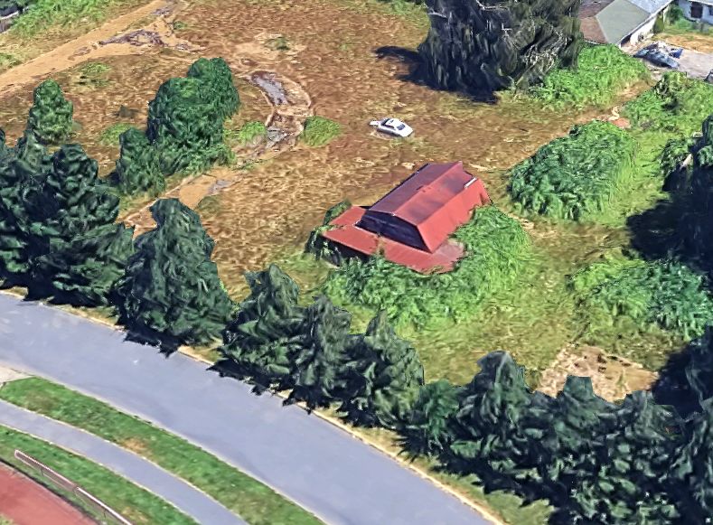
A 2025 3-D aerial image looking northeast at the former Martha Lake Airport operations building, sadly the last remaining vestige of this grassroots airport.
The site of Martha Lake Airport is located northwest of the intersection of Lakeview Road & 2nd Avenue West.
Thanks to Norman Kellman & David White for pointing out the closure of Martha Lake Airport.
____________________________________________________
Sand Point Airfield / Naval Air Station Seattle (KNEJ), Seattle, WA
47.68, -122.25 (North of Seattle Tacoma International Airport, WA)

In the late 1910s, the King County commissioners began acquiring small farms on this peninsula along western shore of Lake Washington,
according to the website of Seattle Parks & Recreation.
In 6/19/20, a ground-breaking ceremony was held for King County's first airfield that included a symbolic tree cutting & the first aircraft landing on the site.
Purportedly, Bill Boeing flew his first airplane from the field.
The earliest depiction of the Sand Point airfield which has been located
In 1923, the U.S. Army leased the field from the Navy & shipped a sheet-iron hangar
(which eventually became known as Building 1) from California & erected it at Sand Point.
In 1924, aircraft squadrons of the "Battle Fleet" established a camp at Sand Point.

A 1924 photo of one of the Douglas World Cruisers at Sand Point.
On 4/6/24, four Army Douglas World Cruiser biplanes, named Boston, Chicago, New Orleans and Seattle, departed Sand Point to conduct the world's first aerial circumnavigation of the globe.
The lead aircraft crashed in Alaska on April 30, and the other 3 aircraft continued west across Asia
The 3 surviving aircraft returned to Seattle on 9/28/24. The flight covered 23,942 nm, with total flight time of 371 hours.

On 9/28/24 photo of the 3 surviving Douglas World Cruisers upon their return to Sand Point (courtesy of Tom Imrich).
A World Flight reception was held at Sand Point, with an estimated public attendance of 40,000.

A March 1925 photo of a metal hangar at Sand Point which had been furnished by the Army & erected by King County.
In September 1925, King County Commissioners authorized clearing of a 2,640' landing strip followed by grading, leveling and sowing in grass.
Pilots seeded the runway to give it a more reliable turf surface, which nevertheless turned to mud in the winter & dust in the summer.
Clarence Blethen of The Seattle Times paid for piping to be laid & for ditches to be dug divert water runoff.
In 1926, Sand Point was still no more than a series of farms, a field served as a runway,
the station commander worked out of a farm house (Imbree residence), and Naval Aviation Cadets were billeted in a chicken house.
In mid-1926, King County jail inmates were used to clear trees & undergrowth to expand the airstrip.
In October 1926, the Carkeek family sold Carkeek Park to King County,
which in turn deeded the entire peninsula (approximately 411 acres) to the U.S. Navy for developing a Naval Air Station.

On 9/13/27, a visit by Charles Lindbergh & his aircraft, the “Spirit of St. Louis”, drew an estimated public attendance of 50,000 to Sand Point.

A 9/13/27 photo of Charles Lindbergh & his aircraft, the “Spirit of St. Louis”, at Sand Point.

A circa late-1920s/early-1930s aerial view looking south at the Naval Air Station runway & seaplane base,
showing a dozen aircraft parked along the runway.
Buildings 2, 5A, 5B, 5C, 5D, 9, and 20 were constructed in 1928-29.
In 1929 a seaplane runway was constructed near the shore of Pontiac Bay.
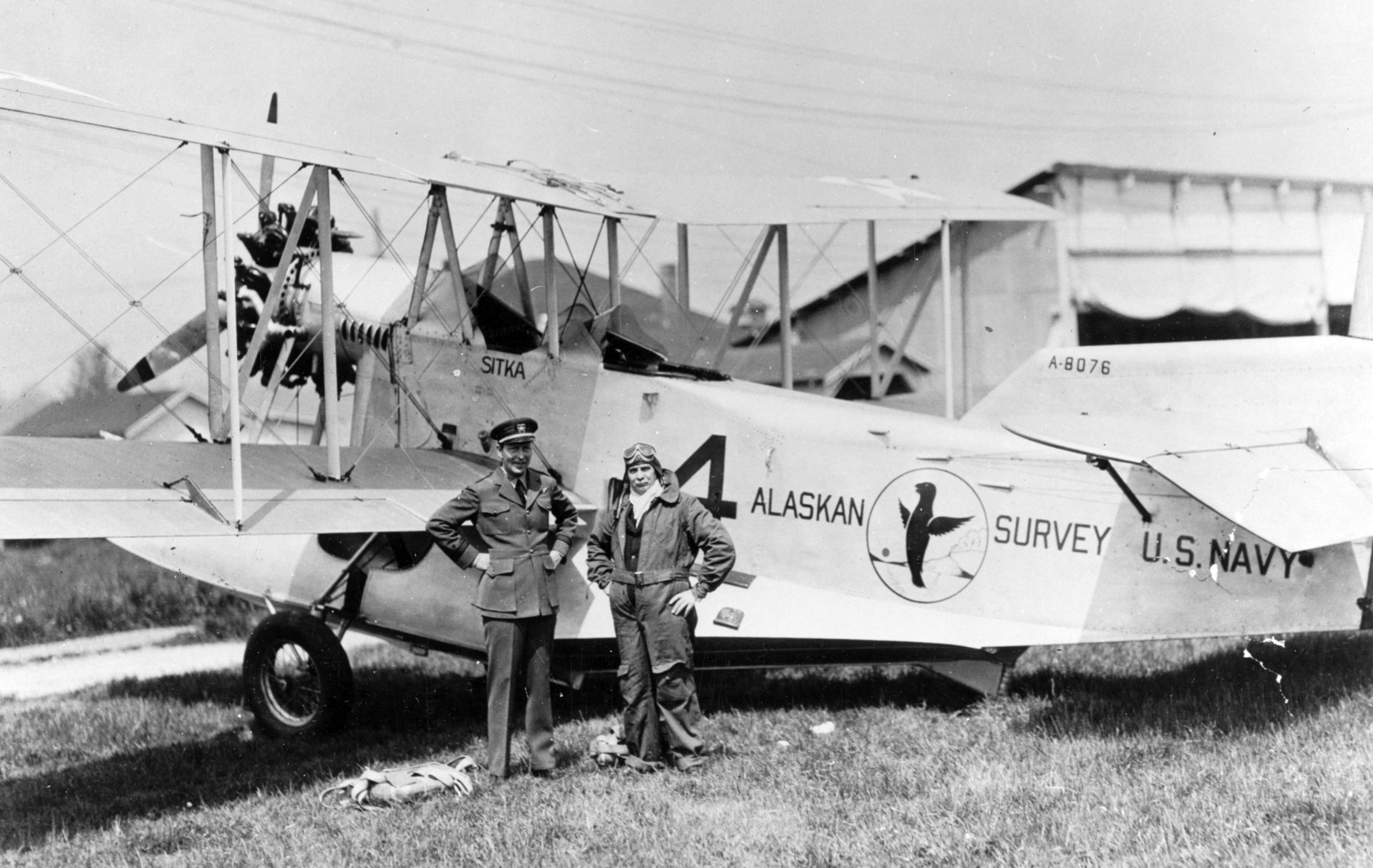

The earliest map depiction which has been located of NAS Seattle was on a circa 1930 Thomas Brothers map (courtesy of Kevin Walsh).
It depicted the “U.S. Navy Sand Point Air Field”, but with no details.

A 1930 aerial view looking south at Buildings 1, 2, and 9, the seaplane base at Pontiac Bay.

The earliest aeronautical chart depiction which has been located of NAS Seattle was on the 1933 Seattle Airways Chart.
It depicted the “U.S. Naval Air Station” as having an airfield & seaplane base.
In the early to mid-1930s, coordinating with the Works Progress Administration,
the Navy trucked in hundreds of loads of fill to develop expanded landing facilities.
Hundreds of WPA workers covered most of the point's "gently rolling land",
buried what remained of Mud Lake & the marsh, and eliminated Pontiac Bay.
This fill material was graded & much of it covered with a slab of concrete for landing strips.

The earliest Sectional Chart depiction which has been located of NAS Seattle was on the September 1934 Seattle Sectional Chart.
It depicted the “U.S. Naval Air Station” as having an airfield & seaplane base.

An 8/27/35 aerial view looking southeast at NAS Sand Point.

A 1936 plan for the “Municipal Seaplane Base at Sand Point” depicted a hangar, administration building, and a future hangar.
Buildings 6, 15, 18, 19, 21, 25, 26, 27, 29, 30, 31, 41, 330, 331, and 332 were constructed in 1936-39.

A circa 1930s photo of a Douglas RD-2 amphibian VJ-1F 1-J-1 at NAS Sand Point.
In 1937 Pontiac Bay (approximately 2.7 acres) was filled in to construct Building / Hangar 27 & its adjacent tarmac.

A 1937 view of 4 Consolidated PBY Catalina flying boats on the Sand Point ramp, with several others on the water in the background.
In 1939 Commander A. W. Radford noted in a memo that grading of the airfield involved more than 1,500,000 cubic yards.
According to http://www.sandptnavsta.org/Sikorsky.html, “In 1939, Pan American Airways began Clipper service to Alaska
from the county park land at Matthews Beach, just north of Sand Point Naval Station.
Pan Am also used Sand Point hangars & runways.”

From August 1940 - September 1941, a total of 5 runways were paved with asphalt
(the longest being 3,700', the other four being 3,000').

A 1941 aerial view looking north at the Sand Point runways while under construction, with the existing hangars visible at the top-left.
By November 1941, the area of the station measured 460 acres.
In 1941 many new barracks were constructed, "the product of months in which tractors & bulldozers moved earth night & day."
By 1941 the urban development of surrounding Seattle had come close enough to the base
that aircraft were no longer permitted to carry live bombs.
By 1942 the size of the station had increased to 471 acres.
The base turned into an air transport & ship staging area for Western Pacific operations during WW2.
It also continued to be used for training, with schools for aviation metalsmiths, machinists & radiomen.
At times, Boeing used the field.
Sand Point also had an outlying field during WW2: Kitsap County Airport (7.5 miles southwest of Bremerton), later to become Bremerton National Airport.
In 1943 the main runway was lengthened to 5,050'.

A 6/30/44 plan of NAS Seattle showed the extensive aviation infrastructure at the base.
During World War II, NAS Seattle's peak work force encompassed 7,400 military & civilian personnel.

A circa 1940s photo of a Navy Curtiss SB2C-5 Helldiver of Attack Squadron 5A after performing a wheels-up landing at NAS Sand Point.
The 1945 AAF Airfield Directory (courtesy of Scott Murdock) described Seattle NAS
as a 471 acre irregularly-shaped property within which were 5 bituminous runways, with the longest being the 5,050' NNW/SSE strip.
The field was said to have 6 hangars, with the largest having a 320' x 31' door,
be owned by the U.S. Government, and to be operated by the Navy.

A circa 1940s photo of a Goodyear FG-1D Corsair from NARTU at NAS Sand Point.

A 1946 aerial view looking south at NAS Seattle (National Archives photo).
By 1946, 4,600 Navy, Marine Corps, and civilian personnel called Sand Point home or worked on the base.

The October 1946 Seattle Sectional Chart depicted NAS Seattle as having a 5,100' paved runway, a control tower, and an adjacent seaplane base.
In 1947 rumors spread that NAS Seattle was to be closed due to the impending creation of the independent U.S. Air Force.
During the years following WW2, the Navy was choosing its permanent post-war bases.
Many closed because they couldn't meet the requirements of the jet age: 6,000' runways were now the minimum standard.
Approach paths had to be suitable for radar-controlled approaches in any weather.
In 1949, the Navy decided that NAS Seattle, the pre-war major naval installation in the Northwest,
was suitable to train Reserve forces and support a moderate number of aircraft,
but could not be expanded as a major fleet support station.
The location of the base, with the length of the runways constrained by Lake Washington, sealed its fate.
It was thus designated a Naval Reserve Air Station. In 1950, the Korean conflict renewed base activity.

A 5/25/51 view of a PBY Catalina amphibian being maneuvered onto ramps at Sand Point (U of WA Libraries, courtesy of Rex Ricks).
Was this an arrangement for moving the planes into the water?
In 1952, the Navy closed the base except for Naval Reserve activities.
The 1953 Master Shore Development Plan for NAS Seattle
estimated the physical plant value at $70 million, and estimated the station size at 450 acres.

A 1953 aerial view looking west at NAS Seattle.

In 1957 Seattle's Comprehensive Plan identified Sand Point Station as a site for a major public park.
The request to create such a park from surplus air base lands was forwarded to the General Service Administration.
The city stated that a general aviation airstrip was totally incompatible with Seattle's plan.
In the late 1950s, rumors spread that jet aircraft might be stationed at NAS Seattle,
which would have required the extension of runways & construction of jet fuel storage.

The 1960 Jeppesen Airway Manual (courtesy of Chris Kennedy) depicted Seattle NAS as having 2 paved runways (5,050 Runway 14/32 & 3,110' Runway 1/19), as well as 2 other abandoned runways.
However, a note said "Runway 19 landing light aircraft only." Buildings (hangars?) were depicted on the west & southwest sides of the airfield.

An early 1960s photo of Douglas R4D-5 39064 in front of a Sand Point hangar.

An early 1960s photo of Douglas A-1E Skyraider 132400 at Sand Point.
By 1963, the size of NAS Seattle was 495 acres.
Carl Sargent recalled, “My father EQCM LeRoy Sargent, established a Seabee Reserve Training Center at Hangar 27 at Sand Point in 1960.
It was the first Seabee Reserve Training center in the country. The facility was commissioned by the secretary of the Navy in 1963. It trained over 500 reservists.”

A 1964 photo by LeRoy Sargent of the exterior of Sand Point's Hangar 27 (courtesy of Carl Sargent).

A 1964 photo by LeRoy Sargent of the interior of Sand Point's Hangar 27 (courtesy of Carl Sargent).
The June 1965 Seattle Sectional Chart (courtesy of Ron Kunse) depicted NAS Seattle as having 3 paved runways, with the longest being 5,000'.
In 1966 the station population included 482 active duty, 1,471 reserve naval personnel, and 318 civilians.

A circa 1960s photo of several aircraft (A-1s, an S-2, a P-2, etc.) at Sand Point.
In 1967 Sand Point gained a Coast Guard Air Station, which was relocated from Port Angeles.

A 8/30/68 USGS aerial view showed a total of 18 aircraft on Sand Point's northwestern ramp, with the largest being 4 Fairchild R4Q Flying Boxcar transports.
In 1969 Sand Point's main runway was resurfaced & extended from the southeast to northwest shore, a length of 4,800', with an estimated cost of $500,000.

The last aeronautical chart depiction which has been located showing NAS Seattle still open was on the December 1969 Seattle Sectional Chart.
It depicted NAS Seattle as having 3 paved runways, with the longest being 5,000'.
In 1970 the Navy announced that it would retain a small portion of Naval Air Station Seattle
and 347 acres would be declared surplus for other purposes.
On 6/30/70 the U.S. Navy deactivated the Naval Air Station, ended all flight operations, and renamed the base as Naval Support Activity – Seattle.
Plans to convert part of the site to a general aviation airport were defeated in a referendum.
Late in its life, Sand Point also was home to Army Reserve helicopter operations.
According to Hooker History, “On 4/1/71, the 92nd Aviation Company (ASH) was consolidated in the US Army Reserve & activated at Sand Point Naval Air Station,
and took over the assets of the 617th Aviation Company at Sand Point Naval Air Station.
On that same date by General Order 139, Headquarters 6th US Army, the 92nd Aviation Company became a Chinook [CH-47] outfit.
The 92nd continued to operate a single OH-23C (floats), and later, four OH-23Ds, as well as 5 OH-13s.”
The 3 paved runways of NAS Seattle were still depicted on the June 1971 Seattle Sectional Chart, but the airfield was labeled as closed.
According to Hooker History, “The first CH-47A, tail number 118, arrived at Sand Point on 12/2/72, flown by Captain Errol VanEaton.
By April 1973 a second CH-47 had arrived. At this time the unit had 20 Officers, 26 Warrant Officers, 124 Enlisted for a total troop strength of 170.
We had 2 CH-47As, 4 UH-1D Hueys, and 1 OH-23C. Twenty-one pilots were CH-47 qualified with 32 Aviators on Flight Status.
Twenty-one Aviators were attached for flight training. There were 16 Crewmembers & 6 Non-crewmembers in the unit.
By the end of 1973 the Hookers had a total of 27 A-model Chinooks assigned to them.”
The 92nd Aviation Company relocated from Sand Point to Paine Field at some point between 1973-84.
Three runways of "Seattle NAS" were still depicted on the 1974 USGS topo map.

The 3 paved runways of NAS Seattle were still depicted on the July 1974 Seattle Terminal Chart, but the airfield was labeled as closed.

An August 1974 aerial view looking north at the abandoned runways during the Gold Cup Hydroplane Race.
The race was held in the waters adjacent to Sand Point, drawing an estimated attendance of 30,000-35,000.
Event parking was held on the remaining airfield tarmac.

A beautiful July 1975 photo of a Blue Angels Douglas A-4F Skyhawk 154176 retracting its landing gear just after takeoff from NAS Sand Point.

A July 1975 photo of a Boeing CH-46D Sea Knight 153325 from the NAS Whidbey SAR detachment seen at NAS Sand Point.
In 1975, a total of 312 Sand Point acres were declared surplus: 117 acres were transferred to NOAA,
and 196 acres were transferred to the City of Seattle for Sand Point Park.
In 1975 the Sand Point Park Master Plan proposed development of a 75-acre Sports Meadow,
tennis courts; neighborhood park; maintenance complex, and restaurant.
Sand Point Park was dedicated in December 1975.
In 1976 the reported "Sand Point Park: A Final Statement on Impact" proposed demolition of structures & runways,
development of a sports meadow & drained playfields,
North Cove Swimming Beach, boating center, and interior circulation system.
In May 1977, the park was renamed in honor of Senator Warren Grant Magnuson.

A 9/5/77 USGS aerial view showed that demolition had begun on Sand Point's runways.
In the late 1970s, demolition was conducted of runways, tarmac and taxiways, encompassing approximately 120 acres.
In the late 1970s, construction begun on the National Oceanic & Atmospheric Administration's
Western Administrative Support Center on a portion of the former Navy property.

The last photo which has been located of an aircraft operating from Sand Point was a 1978 photo of the Goodyear Blimp Columbia.
The former airfield was no longer depicted on the 1979 USGS topo map – it had been replaced by Magnuson Park.
Building 1, which had been built as Sand Point's first hangar in 1923, was demolished by NOAA in the 1970s or 1980s.
A 1980 aerial view showed the runway having been removed, with only an outline of its southern portion still recognizable.

A 1983 photo (courtesy of Lee Corbin) of a Chance Vought F4U Corsair as it was hauled out of Lake Washington. It had ditched off the end of the Sand Point runway & sank in the 1950s.
In 1985 the Naval Support Facility - Seattle housed the offices of the Navy's supervisor of shipbuilding, a recruiting office, and a public-relations office.
The workforce encompassed 1,000 military personnel & 1,182 civilians.
In October 1986 the base was redesignated as Naval Station Puget Sound.
In the late 1980s the "Sand Point Site Development Master Plan, Naval Station Puget Sound" proposed using Naval Station Puget Sound for support facilities.
In April 1991 the Naval Station Puget Sound was recommended for closure under the Base Realignment & Closure Act (BRAC).
Sand Point's former hangars were reportedly used in the 1993 movie “Sleepless in Seattle” as soundstages to film Empire State Building scenes.
The Navy ceased its use of its remaining portion of the base in 1995.
Lee Englund reported in 2003, "all the hangars remain. Most are of all brick construction & first-class."

A circa 2005 aerial photo looking west at former hangars on the north end of Sand Point.

A circa 2005 aerial photo looking west, at the southern-most former hangar at Sand Point.

A 6/19/17 photo by Paul Freeman of the monument commemorating Sand Point's 1924 World Flight, which remains at the former entrance of NAS Sand Point.

An undated photo of the plaque commemorating Sand Point's 1924 World Flight, which remains at the former entrance of NAS Sand Point.

A 6/19/17 photo by Paul Freeman of a former Sand Point hangar, fenced off but in good condition.

A 6/19/17 photo by Paul Freeman of the interior of a former Sand Point hangar.

A 6/19/17 photo by Paul Freeman of a former Sand Point hangar, painted with the Coast Guard logo.

A 6/19/17 photo by Paul Freeman of a former Sand Point hangar.

A 6/19/17 photo by Paul Freeman of a crest at the top of a former Sand Point hangar.

A 2018 aerial view looking southeast at the site of Sand Point NAS.
The seaplane ramp remains, along with a number of hangars & buildings at the northwest side (bottom-left), but only small portions of once-extensive runways remain.

A 6/5/21 aerial view looking southwest at the site of Sand Point NAS by Tim Nelson, author of Jet City Rewind.

A closeup of the Sand Point hangars from the 6/5/21 aerial view looking southwest by Tim Nelson, author of Jet City Rewind.
See also: http://www.vpnavy.com/nasseattle_history.html
____________________________________________________
Or if you prefer to contact me directly concerning a contribution (for a mailing address to send a check),
please contact me at: paulandterryfreeman@gmail.com
If you enjoy this web site, please support it with a financial contribution.
____________________________________________________
This site covers airfields in all 50 states.