Abandoned & Little-Known Airfields:
Northern Vermont
© 2003, © 2026 by Paul Freeman. Revised 7/2/26.
This site covers airfields in all 50 states: Click here for the site's main menu.
____________________________________________________
Please consider a financial contribution to support the continued growth & operation of this site.
Bristol Airport (revised 7/2/26) - Brown Airport / St. Johnsbury Airport (revised 12/29/25) - Champlain Airport (revised 2/21/26)
Fort Ethan Allen AAF (revised 12/4/25) - Missisquoi Airport / Warren Austin Airport (added 12/29/25) - Wood Airfield / Caledonia Airfield (revised 11/18/20)
____________________________________________________
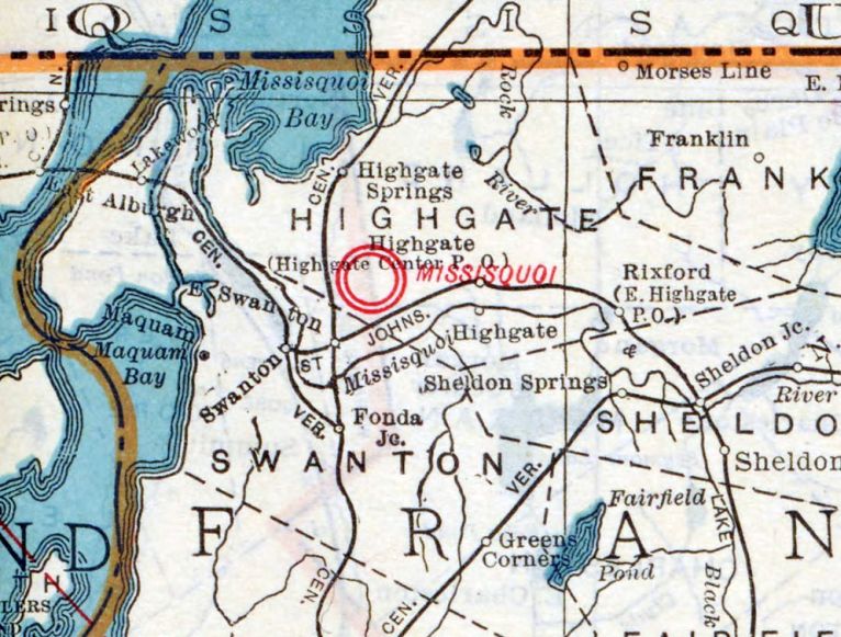
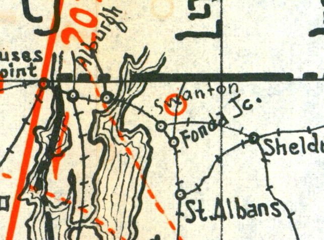
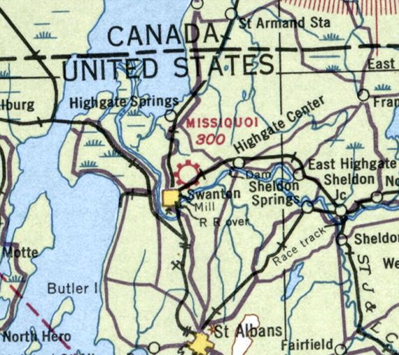
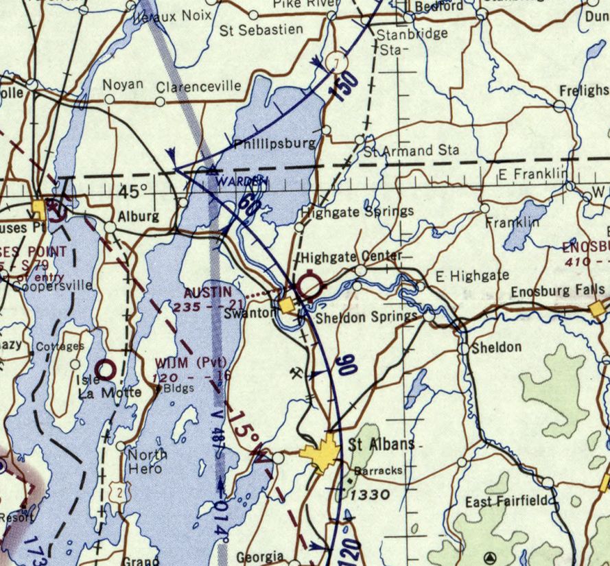
Missisquoi Airport / Warren Austin Airport, Swanton, VT
44.933, -73.088 (Northwest of Boston, MA)
Missisquoi Airport, as depicted on the 1929 VT Air Trails (courtesy of the David Rumsey Historical Collection).
According to a 2019 Franklin County State Airport Resource Identification Report prepared by Hunt & Mead for the VT Agency of Transportation (courtesy of Jonathan Westerling),
“The Swanton Airport has its origins in the mid-1920s, when local residents assisted a struggling pilot who had been forced to land in a farmer’s field near the village.
The pilot was unable to take off again due to the wet surface conditions in the field, and villagers towed the plane to the area known as the 'hempyard', where the sandy soil was better drained.
Several years later, this event served as the inspiration for the selection of this site as a potential new airport.
A group of local flying enthusiasts formed the Missisquoi Airport Corporation in July 1928 & improvement efforts began soon after.
By the summer of 1929 three runways had been laid out (1,450', 1,550', and 1,850') and plans were in progress to construct a circle of white crushed stone as a visual aid.”
The earliest depiction which has been located of Missisquoi Airport was on the 1929 VT Air Trails (courtesy of the David Rumsey Historical Collection).
The Hunt & Mead report continued, “An Esline arched-truss hangar was added in 1930 & served as the main hangar.
Located only a few miles south of the Canadian border, the Missisquoi Airport was officially designated as an international port of entry in 1930, one of 6 border airports in the nation to receive this status.
The formal dedication ceremony on July 25 was marked by an air-meet of military and civilian planes, flying contests, and parachute demonstrations.
Its status as a port of entry, serviced by customs & immigration officials from the nearby Highgate border station, proved a boon to the new airport.”
Missisquoi Airport, as depicted in the 1931 Pilots Handbook (courtesy of Jonathan Westerling).
The Hunt & Mead report continued, “By 1931 the Missisquoi Airport was described as 'the northern gateway for New England air traffic'.
A concrete floor had been added to the new hangar building & the airport was reportedly well regarded by aviators for its size, condition, and efficiency of customs officials.
The airport also offered training through a flight school operated by local pilot Ralph Stancliffe.
The report continued, “The Missisquoi Airport remained privately owned.
The airport land was purchased from the previous owners by Chester Way in 1932 & was leased to the Village of Swanton in 1934.
The federal government provided a $10,000 federal grant to make improvements early that year, including expansion of the main runway to 2,000'.
Federal funding provided $16,000-$20,000 to improve the Swanton facility by 1935.
Regional commercial airline service began to develop in New England in the mid-1930s, and the Boston & Maine & Central Vermont Railroads founded an early carrier that was later known as Northeast Airlines.
By 1933 passenger routes flew between Boston & Barre-Montpelier.
At that time, the Missisquoi Airport received flights inbound from Canada as Swanton was the sole port of entry in the area & provided customs & immigration services.
With the introduction of a daily Boston-Montreal commercial route soon after, Swanton continued to serve as the primary port of entry.”
The earliest aeronautical chart depiction which has been located of Missisquoi Airport was on the 1936 Burlington Sectional Chart (courtesy of Jonathan Westerling).
It depicted Missisquoi as a commercial/municipal airport.
The earliest photo which has been located of Missisquoi Airport was an undated aerial view looking south from the 1937 Airport Directory Company Airport Directory (courtesy of Jonathan Westerling).
It described Swanton Airport as being a 100 acre triangular gravel property having 3 gravel runways, the longest being 2,000' east/west & northwest/southeast, with the note “Runway under construction.”
The Hunt & Mead report continued, “By 1940 the Swanton airport was primarily used by private aircraft & smaller commercial planes.
The CAA designated 3 airports for instruction of non-college fliers in 1940, at the Swanton, St. Johnsbury, and Springfield airports.
As part of the non-college program, Harold Pugh took over management of the Missisquoi Airport in 1940 & opened a branch of Fli Rite shortly thereafter.
Pugh’s training program at Swanton was short-lived, however, and by the fall of 1941 his planes & instructors were needed at the Burlington airport instead.
A branch of the Fli Rite School was revived at the Missisquoi Airport in 1944 under the management of Pugh’s associate Arthur Viens.”
An undated aerial view looking northeast at Missisquoi Airport from the 1944 AAF Airport Directory (courtesy of Jonathan Westerling).
It described Missisquoi Airport as being a 160 acre irregularly-shaped property having 4 sod runways, the longest being 2,000' northeast/southwest & northwest/southeast.
It was described as being owned by private interests, but “Not in operation.”
The Hunt & Mead report continued, “In the postwar period improvements continued at the airport, which property owner Chester Way renamed to honor Senator & Highgate native Warren Austin in 1946.
Under Fli Rite’s supervision, the airport was one of 4r Vermont airfields to receive a National Aeronautic Association award later that year; recognizing good operating practice.
By 1946 the airport had 5 T-hangars in addition to the main arch-truss hangar, and a repair shop was added to the rear of the main hangar that year.
Although airport officials announced plans to build 12 additional hangars for private planes in 1946, a single 120'x100' prefabricated steel hangar was constructed in 1948 instead,
at which time the runways were also lengthened by 1,000'.
The field was considered private by the early 1950s.”
The report continued, “Due to its limited development, flight operations at the Warren Austin Airport were relatively limited.
Use of the airport by international flights was threatened in 1952, when officials looked at stripping the airport of its status as a port of entry.
At the time, the Burlington and Warren Austin Airports were the only 2 port of entries in Vermont though,
as newspapers noted, 'Most pick Burlington, [as Warren Austin] has no paved runways.'
In 1956 a Burlington trucking firm announced plans to build a shipping terminal at the Warren Austin Airport.”
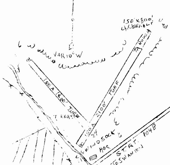
The 1957 VT Airport Directory (courtesy of Jonathan Westerling) described Warren Austin Airport as having 2 turf runways (2,100' northeast/southwest & 1,800' northwest/southeast),
operated & managed by Earl Smith.
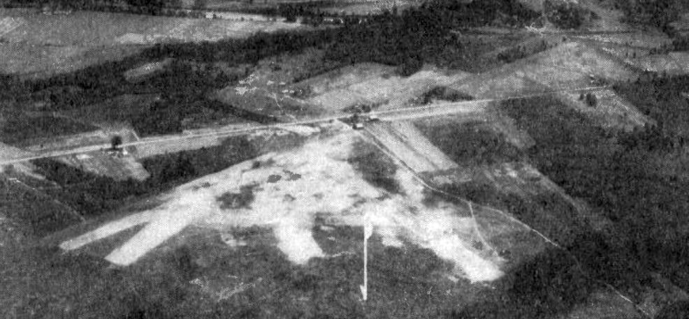
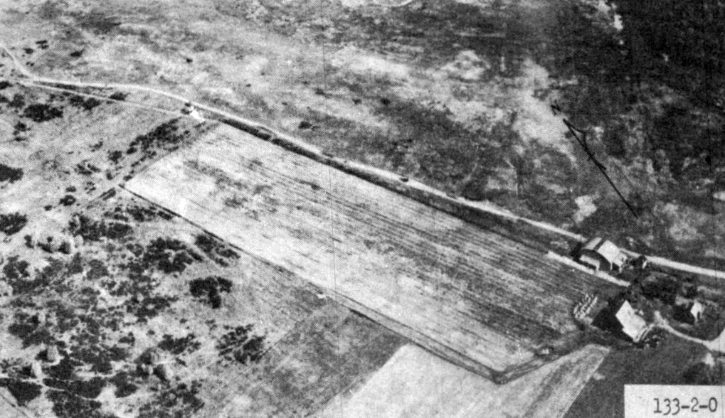
An annotated 1960 aerial view of Missisquoi Airport (from a 2019 Franklin County State Airport Resource Identification Report prepared by Hunt & Mead for the VT Agency of Transportation).
An annotated 1962 aerial view of Missisquoi Airport (from a 2019 Franklin County State Airport Resource Identification Report prepared by Hunt & Mead for the VT Agency of Transportation).
The Hunt & Mead report continued, “The terminal may have never come to fruition or have closed by 1962, when the Burlington Free Press noted that the airport was 'used little.'
That same year a joint Canadian-American military parachute training center was proposed at Warren Austin Airport.
The program operated for only 3 weekends before being discontinued.
By 1963 newspaper accounts described the airport as nonoperational, though it continued to be listed as a privately-owned field open to public use in the biennial report of 1963-1964.
Not wanting to give up a potential money-making asset, business leaders in the nearby Town of Swanton began to push in 1963 for making the airport a publicly-owned facility
and thus eligible for federal funding & allowing for further development.
Initially, business leaders headed by Swanton businessman Floyd Handy sought to make the airport a municipal or county-airport, with local funding provided by the Towns of Swanton, Highgate, and St. Albans.
Because of its larger size & county seat designation, the city of St. Albans was a more logical choice for a county airport.
As a result, St. Albans was reluctant to share in the cost of a county airport located at the Warren Austin site & business leaders there pushed for a St. Albans Airport as an alternative.
In response, Handy and others pushed the idea that it was cheaper to renovate an existing airport rather than build a new one.
They also argued that the new I-89, which was under construction in 1963, would provide adequate & speedy connections between the existing airport & St. Albans.
Also, Chester Way, owner of the airport land in 1964, was willing to sell.
As additional incentive, Handy & other Swanton and Highgate business leaders petitioned the governor to locate a proposed Border Patrol station at the Warren Austin Airport,
hoping that the station would lead to the transfer of Border Patrol planes to the airport, making it more likely to become a municipal or county airport.”
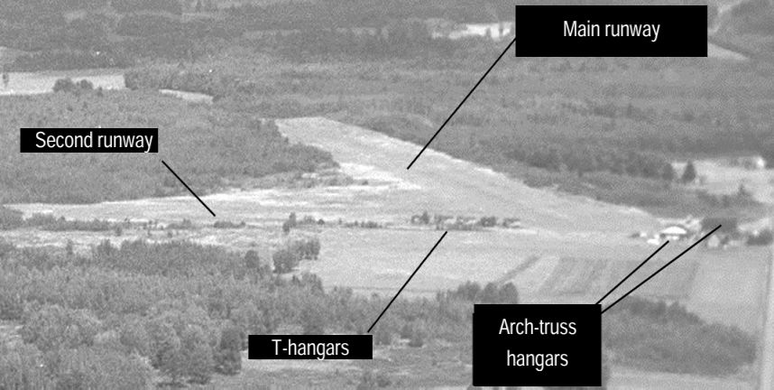
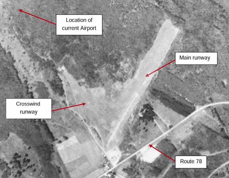
An annotated 1965 aerial view looking northeast at Missisquoi Airport (from a 2019 Franklin County State Airport Resource Identification Report prepared by Hunt & Mead for the VT Agency of Transportation).
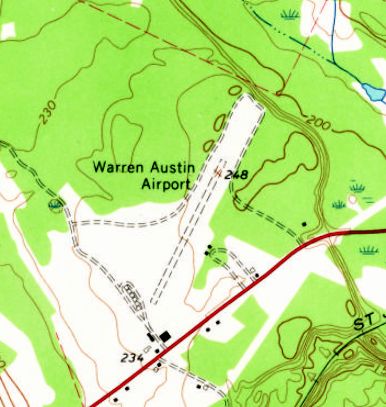
The earliest topo map depiction which has been located of Warren Austin Airport was on the 1965 USGS topo map.
It depicted Warren Austin Airport as having a single unpaved northeast/southwest runway, with 2 small buildings on the east side.
The last aeronautical chart depiction which has been located of Warren Austin Airport was on the April 1965 Burlington Sectional Chart.
It depicted Austin as having a 2,100' unpaved runway.
The Hunt & Mead report continued, “The debate over the future of the Warren Austin Airport shifted in 1966, when the state unveiled the Vermont Regional Airport Plan.
Echoing the 1945-1947 state airport plan, the 1966 plan called for at least 1 publicly owned airport in each county with a paved runway capable of accommodating a twin-engine aircraft.
To accomplish this, the state planned to purchase key municipal airports for $1, which it would then develop, operate, and maintain.
In 1967 the Warren Austin Airport was tentatively chosen as a state-owned regional airport, pending funding for improvements that would allow the facility to handle twin-engine planes.
The approval of this site was likely helped by the fact that, by 1966, Handy had become a member of the VAB.
Disagreements at the state level over funding delayed the development of plans for the new state airport.
For all state airport projects, the FAA would provide half of the funding, with state & local entities making up the other half.
In 1967 the state legislature could not agree on what proportion of the non-federal dollars would come from the state & what proportion from counties, towns, or cities.
A year later state legislators agreed that the state would fund 30 percent of airport development & local entities would fund 20% in addition to the matching funds provided by the federal government.
With a $150,000 grant from the FAA & combined matching contributions from state and local entities, planning of what would become the Franklin County State Airport began in 1969.
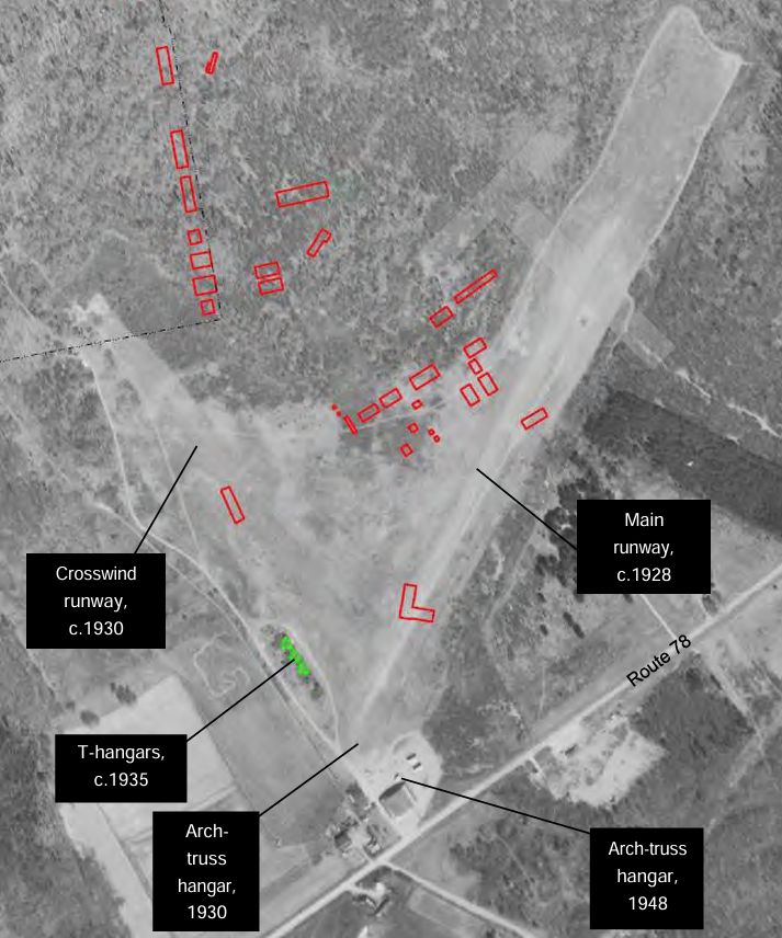
Rather than renovate the existing Warren Austin Airport, planners decided to abandon the old turf runway & hangars & build new runways & structures north of the old airport.”
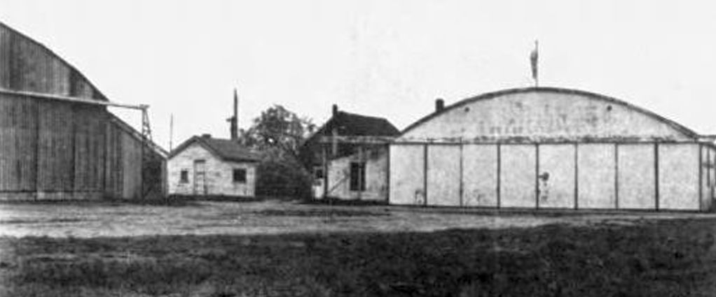
A 1969 photo of 2 arched-truss hangars at Warren Austin Airport before they were moved to the new Franklin County State Airport (from a 2019 Franklin County State Airport Resource Identification Report prepared by Hunt & Mead for the VT Agency of Transportation).
The hangar at left was the 1948 hangar which, after being moved, became the State Hangar and Terminal building in circa 1971.
The shed-roof wing is likely the current terminal & administrative office space.
This hangar was razed circa 1990.
The smaller hangar is the 1930 Esline hangar that was moved circa 1972 & is currently occupied by Prestige Aircraft, Inc.
Warren Austin Airport was presumably at some point between 1969-70, as only the new Franklin County Airport was depicted on the November 1970 Burlington Sectional Chart.
Only the clearing in the orientation of the former runway was still visible in a 1981 aerial photo,
with all other traces having been removed of the Warren Austin Airport.
Only the clearing in the orientation of the former runway was still visible in a 2024 aerial view looking northwest,
with all other traces having been removed of the Warren Austin Airport.
____________________________________________________
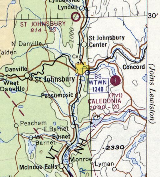
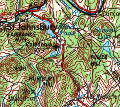
Wood Airfield / Caledonia Airfield, St. Johnsbury, VT
44.4, -71.925 (Northwest of Boston, MA)
Wood Airfield, as depicted on the November 1966 Lewiston Sectional Chart.
This small private airfield was evidently established at some point between 1966-67,
as it was not yet depicted on the April 1966 Lewiston Sectional Chart.
The earliest depiction which has been located of Wood Airfield was on the November 1966 Lewiston Sectional Chart,
which depicted Wood as a private airfield having a single paved north/south 1,800' runway.
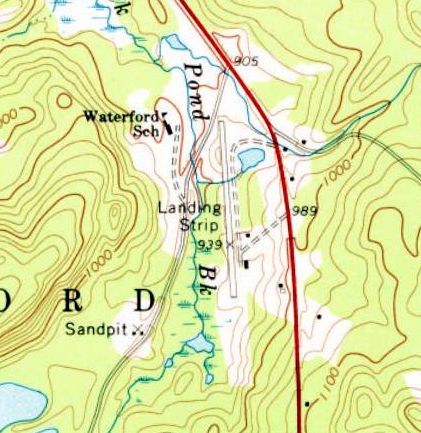
The 1967 USGS topo map depicted Wood Airfield as a single paved north/south runway, generically labeled “Landing Strip”.
According to “Where the Great River Rises: An Atlas of the Upper Connecticut River” by Rebecca Brown (courtesy of Chris Landry),
“Waterford saw a very short paved runway constructed by a concrete construction company.
Its powerful single-engine Cessna routinely landed on highway construction projects throughout VT & NH.”
Wood Airfield was evidently renamed “Caledonia” at some point between 1966-70,
as that is how it was labeled on the November 1970 Burlington Sectional Chart.
It depicted Caledonia as a private airfield having a single paved 2,000' north/south runway.
Caledonia Airfield, as depicted on the 1972 USGS topo map.
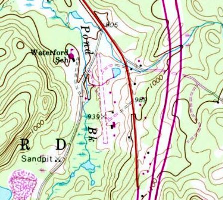
The 1988 USGS topo map depicted Caledonia as an unpaved north/south runway with several small buildings along the east side.
The airfield was not labeled at all.
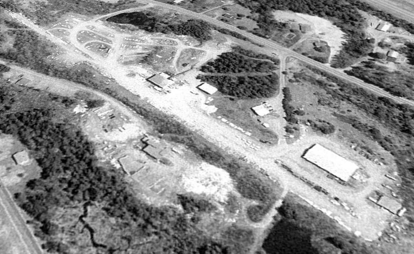
The earliest photo which has been located of Caledonia Airfield was a 1999 USGS aerial view looking northeast.
The airfield had presumably closed at some point between 1970-99, as the runway appeared quite deteriorated.
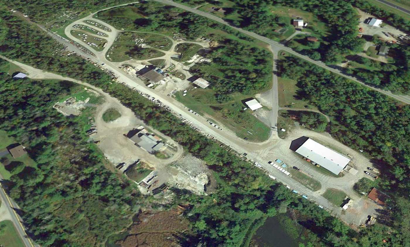
A 2015 aerial view looking northeast showed the Caledonia Airfield runway remained intact though deteriorated, and what appears to be a former hangar remained along the east side of the runway.
Chris Landy reported in 2016, “The company, Calco, Inc., is still there.”
The site of Caledonia Airfield is located south of the intersection of Route 18 & Duck Pond Road.
Thanks to Chris Landry for pointing out this airfield.
____________________________________________________
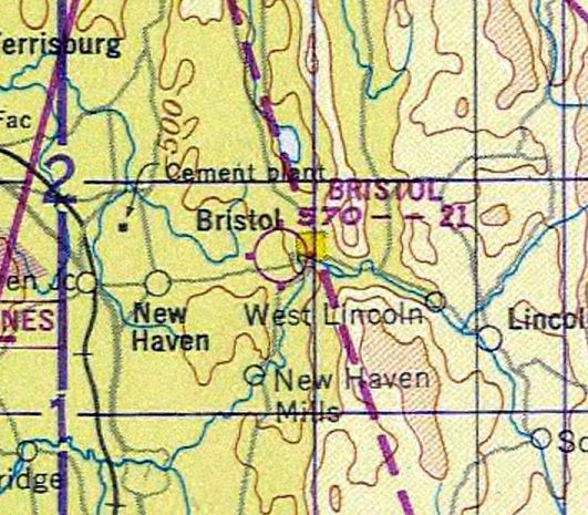
44.135, -73.093 (Northwest of Boston, MA)
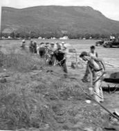
A circa 1930s photo of land being cleared for the construction of Bristol Airport (courtesy of the Bristol Historical Society).
According to Reg Dearborn's article “”History Space: When Bristol had an airport” in the 11/27/15 Burlington Free Press (courtesy of Jim Covington),
“In 1930 an effort was started by the Bristol Vermont Chamber of Commerce under the leadership of Van Patnode to locate a landing field on private land to the north of the Recreation Field.
After considerable work was done on the land that would eventually become the north/south runway pilots began taking advantage of this landing field.
On 1/3/34, members of the Bristol Chamber of Commerce met to discuss securing an airport for Bristol.
An offer had been made to town & village officials through the office of Walter Cleveland of Montpelier, Assistant Director of Airways, to construct an airfield in Bristol.
This was part of a projected program to build airports all over the country by the federal government through the Public Works Administration (PWA).”
Reg continued, “In early January 1934, a group of citizens presented the Selectboard of Bristol
with a petition for a special meeting to authorize the purchase of a suitable site for an airport in Bristol.
At a special meeting held on 1/25/34, it was '... voted to appropriate what money is necessary to purchase land required for use as an airport
and that the selectmen make as good a bargain as possible with land owners.'
This included the land that had been cleared earlier. The eventual total was approximately 55 acres.
This new PWA project was one of the larger ones undertaken by the Selectmen, not necessarily because they wanted an airport, but men could walk to the site.
For most other projects the men had to be transported at the town's expense. In February 1934, the project was approved.
In April surveying was done & 12 men working 3 days a week at 40 cents / hour started work on the east/west runway on approximately 4.2 acres purchased from the Recreation Club.
Improvements were also started on the north/south runway that had been started in 1930.
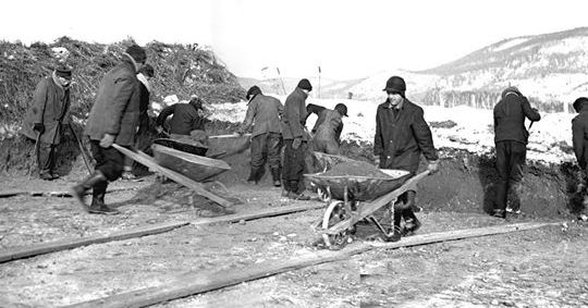
A circa 1930s photo of work crews building the Bristol Airport (courtesy of the Bristol Historical Society).
According to Reg Dearborn's article “”History Space: When Bristol had an airport” in the 11/27/15 Burlington Free Press (courtesy of Jim Covington),
“In April of 1935 the PWA & was replaced by the Works Progress Administration (WPA).
Work continued on the airport with funds from the WPA through 1941.
Work was done with a crew averaging between 16-18 men working mostly with picks, shovels & wheel-barrows.
On 11/30/35 the VT Motor Vehicle Department approved the Bristol Airport to be operated by the town of Bristol as a flying field for commercial purposes.
In 1936, the Bristol Airport Commission was established with George Lathrop as Chairman
and Ridley Norton, George Smith, Foster Whitcomb, Arthur Gove, Lee Landon & William DeCoursey as inaugural members.
On 5/30/36, the official opening of the Bristol Airport was celebrated with an Air Meet sponsored by the Bristol American Legion.
Included was an aerial acrobatics & stunt flying show. Passenger flights were available for $1.50.”
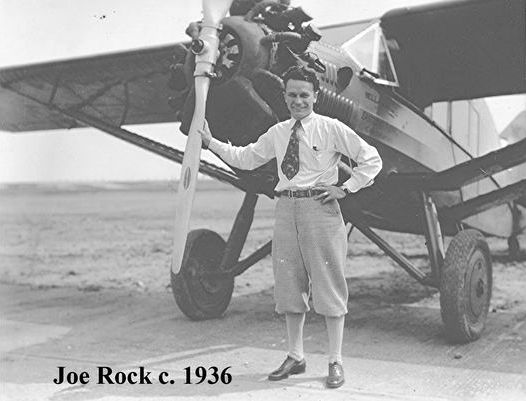
A circa 1936 photo of Joe Rock in front of a Bellanca Skyrocket at Bristol Airport (courtesy of the Bristol Historical Society).
According to Reg Dearborn's article “”History Space: When Bristol had an airport” in the 11/27/15 Burlington Free Press (courtesy of Jim Covington),
“Rock's Flying Service was started in July 1936 after George Lathrop contacted Joe Rock, who was flying for the city of Rutland at the time.
Joe & his wife Cora were persuaded to come to Bristol to operate the new airport.
Cora recalled they 'proceeded to Bristol with a little 37 H.P. Cub Trainer airplane, their Chevrolet & a lot of coura e.'
Cora set up office in the back seat of their car & Joe's shop was the open field with the plane tied to the barbed-wire fence.
Later that first summer the town put up a shack about 9' x 8' for a shop & office.
Soon after this George Lathrop & Ridley Norton constructed a 40' x 50' wood & steel hangar which the Rocks rented.
The Rocks also agreed to pay the Airport Commission 10% of their gross income which they paid weekly.”
The earliest aeronautical chart depiction which has been located of Bristol Airport was on the September 1936 Burlington Sectional Chart,
which depicted Bristol Airport as an auxiliary airfield.
According to Reg Dearborn's article “”History Space: When Bristol had an airport” in the 11/27/15 Burlington Free Press (courtesy of Jim Covington),
“The first winter Cora continued to teach in White River commuting to Bristol on weekends to do the bookkeeping & check that the students kept their logbooks up to date.
By 1937 Joe had traded in his Cub trainer & Cora had cashed in her Teachers Retirement Fund.
They became owners of larger airplanes, both side-by-side & tandem trainers.
In 1937 reports show that 35 students had enrolled for training.
Thirty-one had soloed & 3 had received their private pilots licenses. Students came from all over Vermont as well as Massachusetts.”
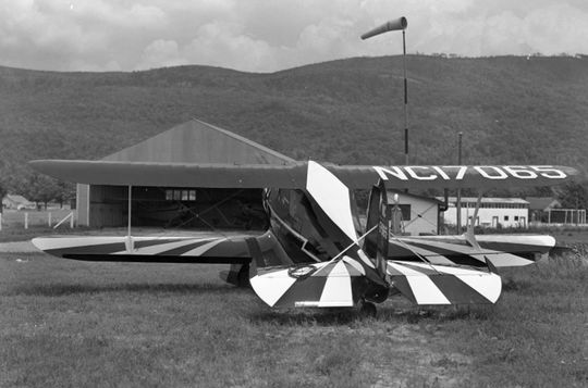
A 7/14/38 photo by George Lathrop of a Beechcraft C17B in front of a hangar & the windsock at Bristol Airport (courtesy of the Bristol Historical Society).
According to Reg Dearborn's article “”History Space: When Bristol had an airport” in the 11/27/15 Burlington Free Press (courtesy of Jim Covington),
“In 1939, Bristol received the first group of students under the Civil Aeronautics Authority (CAA) Training Program.
These were 20 Middlebury College students & included 2 girls.
Cora noted that as this was a new program for the college '…they sent these poor kids up to Bristol at daylight to fly without any breakfast.'
She took coffee & doughnuts to the field every morning so that they could have something to eat before flying.
In 1939, an estimated 63,000 miles of flying originated from the Bristol Airport.
This included 2 emergency trips to the Veterans Hospital in White River Junction.
The Commission also erected an 8' x 18' addition to the office building for the benefit of the public as well as the students.
By 1940, the Rocks were paying $250 to rent the airfield.
They now had 5 planes but with a group of CAA students in the spring & another in the fall another plane was added to handle the increasing number of students.
The 3rd runway in the northwest/southeast direction was also completed.
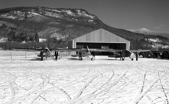
A winter 1940 photo of 3 single-engine high-wing taildraggers in front of a hangar at Bristol Airport (courtesy of the Bristol Historical Society).
According to Reg Dearborn's article “”History Space: When Bristol had an airport” in the 11/27/15 Burlington Free Press (courtesy of Jim Covington),
“In 1941 the new Administration Building was constructed & moved into on Pearl Harbor Day.
After Pearl Harbor Day all airports had to have an armed guard.
The Rocks furnished one for the 12 daytime hours & the town furnished a night guard.
Because a guard had to be armed, Cora Rock, with a .38 Smith & Wesson strapped around her waist took her turn as a guard.
One of the last classes of pilots before the war consisted of 10 college & 10 non-college students.
Among the non-college students were James Bouvier, Lawrence Bouvier, Tom Cushman, Fredrick Eddy, John Smith, Robert Willey, John Cragen, Bill Adams, and Ray Gero.”
A 9/13/42 aerial view looking north from the 1945 AAF Airfield Directory (courtesy of Scott Murdock) depicted Bristol Airport as having an irregularly-shaped grass airfield area.
According to Reg Dearborn's article “”History Space: When Bristol had an airport” in the 11/27/15 Burlington Free Press (courtesy of Jim Covington),
“In 1942 the airport was designated under the Civil Aeronautics Authority (CAA) War Training Service to train reserve Army & Navy students.
The Navy students were trained in conjunction with Middlebury College. That year 120 students completed the flying course.
Pilots continued to be trained under this program until 1944. During that time the airport had about 11 people working as instructors & mechanics.”
The 1945 AAF Airfield Directory (courtesy of Scott Murdock) described Bristol Airport as a 55 acre property having a 3 sod runways, the longest measuring 2,200' north/south.
The field was said to have 3 hangars, to be owned by the Town of Bristol, and operated by private interests.
According to Reg Dearborn's article “”History Space: When Bristol had an airport” in the 11/27/15 Burlington Free Press (courtesy of Jim Covington),
“Between 1941-46 two T-hangars were added to the airfield.
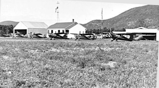
A mid-1940s photo of 6 single-engine high-wing taildraggers in front of the hangars & office at Bristol Airport (courtesy of the Bristol Historical Society).
According to Reg Dearborn's article “”History Space: When Bristol had an airport” in the 11/27/15 Burlington Free Press (courtesy of Jim Covington),
“In 1946 pilot training continued with 30 veterans receiving flight training under the G.I. Bill of Rights.
The Middlebury College Flying Club was also taking flight training here.
Classes were also being held nightly at the airport including Ground School, Civil Air Regulations, Navigation and Meteorology.
Improvements were made to the Administration Building & colored landing lights were installed.
According to the 1946 Bristol Town report it was estimated there were approximately 6,844 takeoffs & landings during 1946.”
The 1948 Burlington Sectional Chart depicted Bristol Airport as having a 2,100' unpaved runway.
According to Reg Dearborn's article “”History Space: When Bristol had an airport” in the 11/27/15 Burlington Free Press (courtesy of Jim Covington),
“In 1949 the Town of Bristol purchased both the large wood & steel hangar from Lathrop & Norton they had erected in 1936 & one of Rock's T-hangars.
Bristol's Ezra Dike purchased the second T-hangar from the Rocks.
In 1949 the Rocks moved a 97' x 26' hangar from Lebanon, NH to Bristol.”
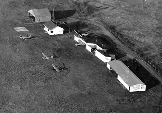
A circa 1950 photo of 4 single-engine light aircraft in front of the hangars & office at Bristol Airport (courtesy of the Bristol Historical Society).
According to Reg Dearborn's article “”History Space: When Bristol had an airport” in the 11/27/15 Burlington Free Press (courtesy of Jim Covington),
“After 1950 business & flights at the airport started to decline.
In 1951 Cora Rock returned to teaching, taking a job in Monkton.”
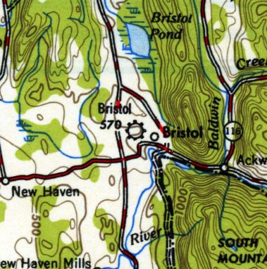
The earliest topo map depiction which has been located of Bristol Airport was on the 1955 USGS topo map.
According to Reg Dearborn's article “”History Space: When Bristol had an airport” in the 11/27/15 Burlington Free Press (courtesy of Jim Covington),
“Because the east/west runway was no longer being used the land that had been purchased from the Recreation Club in 1934
was sold back to the Club in December 1956 for the original purchase price.”
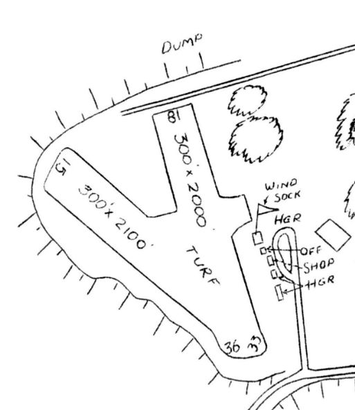
The 1957 VT Airport Directory (courtesy of Jonathan Westerling) described Bristol Airport as having 2 turf runways (2,100' northwest/southeast & 2,000' north/south),
operated by Rock's Flying Service, and managed by Joseph Rock.
According to Reg Dearborn's article “”History Space: When Bristol had an airport” in the 11/27/15 Burlington Free Press (courtesy of Jim Covington),
“In 1958 voters authorized the use of the Administration Building as a Youth Center.
On 10/22/60 Joseph Rock was killed when his plane crashed.
From 1961-64 the Town of Bristol continued to maintain the airport while they searched for an operator for the airfield.
In 1961 a new Airport Commission was authorized consisting of Dewees Brown, William Cardell and James Bouvier.”
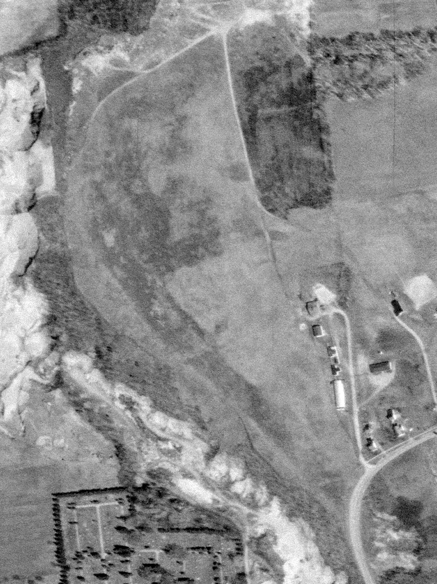
The last photo which has been located of Bistol Airport was a 5/5/61 USGS aerial view.
It showed the airport remained intact, including the grass airfield,
and several small hangars & 1 light single-engine plane were on the southeast side.
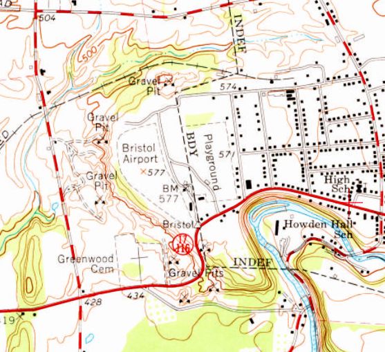
The 1963 USGS topo map depicted Bristol Airport as a very small irregularly-shaped outline with 2 small buildings on the southeast side.
According to Reg Dearborn's article “”History Space: When Bristol had an airport” in the 11/27/15 Burlington Free Press (courtesy of Jim Covington),
“Levi Sturtevent took over the operation of the airport in September 1963.
By 1964 the Bristol Airport was listed as open & operating year round with approximately 100 charter trips & over 300 parachute jumps.
The buildings & runways were cleaned up & about 12 students received flight instruction in 1964.”
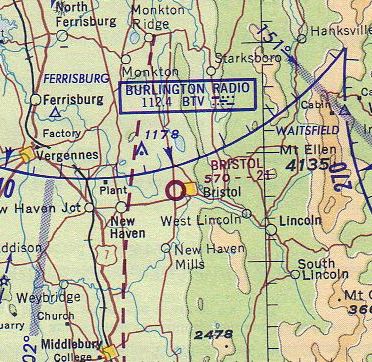
The last aeronautical chart depiction which has been located of Bristol Airport was on the April 1964 Burlington Sectional Chart,
which depicted Bristol Airport as having a 2,100' unpaved runway.
According to Reg Dearborn's article “”History Space: When Bristol had an airport” in the 11/27/15 Burlington Free Press (courtesy of Jim Covington),
“By 1966 use of the airport had again declined & on 11/29/66, the town of Bristol sold the land for $38,000
to the newly formed Addison Northeast Union School District for the location of their new high school.
In the fall of 1968, Mount Abraham Union High School opened on the site where thousands of airplane landings & takeoffs had occurred for more than 30 years.”
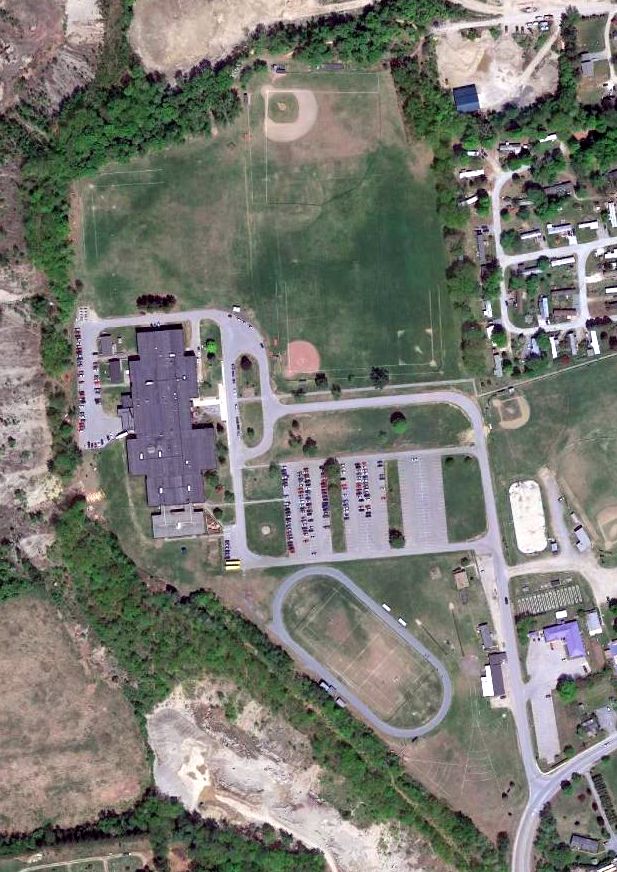
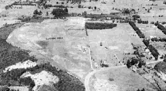
A 2015 aerial view showed the outline of the Bristol Airport property was the sole remaining trace of the little airport.
The site of Bristol Airport is located at the end of Airport Drive, appropriately enough.
Thanks to Jim Covington for pointing out this airfield.
____________________________________________________
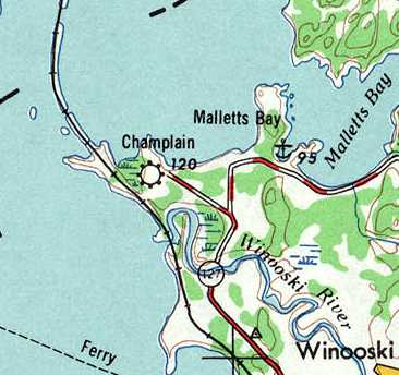
Champlain Airport, Colchester, VT
44.545, -73.282 (Northwest of Boston, MA)
Champlain Airport, as depicted on a 1946 aerial view looking west.
This little general aviation airport was evidently established at some point between 1946-47,
as it was not yet depicted on the June 1946 Burlington Sectional Chart.
The earliest depiction of Champlain Airport which has been located was on a 1946 aerial view looking west.
It depicted Champlain Airport as having 2 unpaved runways with an airport circle marking at the intersection, and a barn on the southeast side.
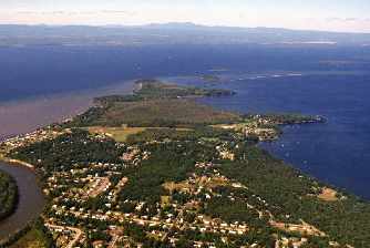
“This little airstrip served the community known as Mallet’s Bay in Colchester just north of Burlington”, according to Jonathan Westerling.
“Mallets Bay started out as a collection of Summer cottages,
and many of its residents would fly into this little airport for their summer stays.”
The earliest topo map depiction of Champlain Airport which has been located was on the 1947 USGS topo map.
The earliest aeronautical chart depiction which has been located of Champlain Airport was on the 1948 Burlington Sectional Chart (courtesy of Roger Connor),
which depicted Champlain as having a mere 1,700' runway.
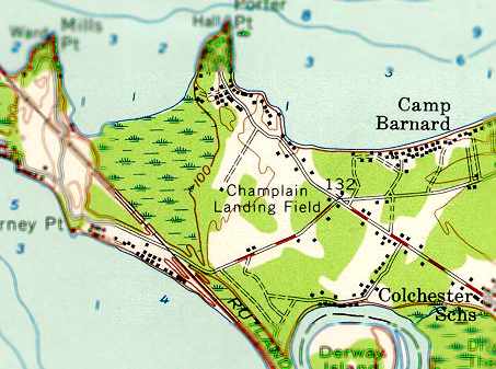
The 1956 USGS topo map depicted “Champlain Landing Field” as an open area, without any other details.
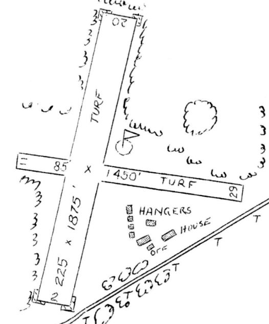
The 1957 VT Airport Directory (courtesy of Jonathan Westerling) described Champlain Airport as having 2 turf runways (1,875' north/south & 1,450' east/west),
operated by Champlain Flying Service, and managed by Charles Brink.
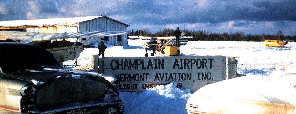
A 1961 photo of Champlain Airport by Doug Riach shows a typically snowy VT scene,
with 3 Pipers, a hangar, and the airport sign.
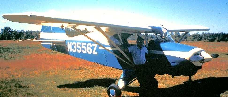
A 1961 photo (courtesy of Doug Riach) of Doug in front of a Piper Tri-Pacer at Chaplain Airport.
 A
A
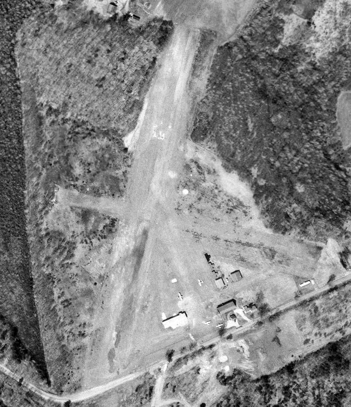
A 4/27/64 USGS aerial view depicted Champlain Airport as having 2 perpendicular grass runways, with 4 single-engine aircraft parked around a collection of hangars on the southeast side.
The 1967 AOPA Airport Directory (according to Jonathan Westerling) described Champlain as having 2 sod runways: 2,000' Runway 2/20 & 1,475' Runway 11/29.
It was said to be attended daily, and had facilities for minor repairs. The operator was listed as Vermont Aviation.
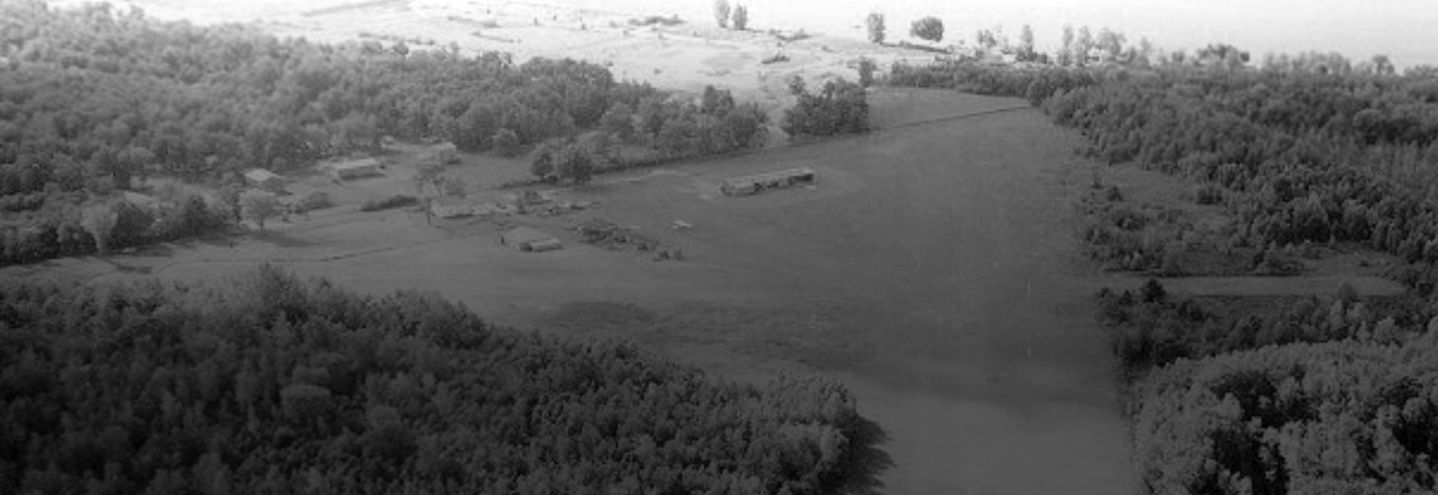
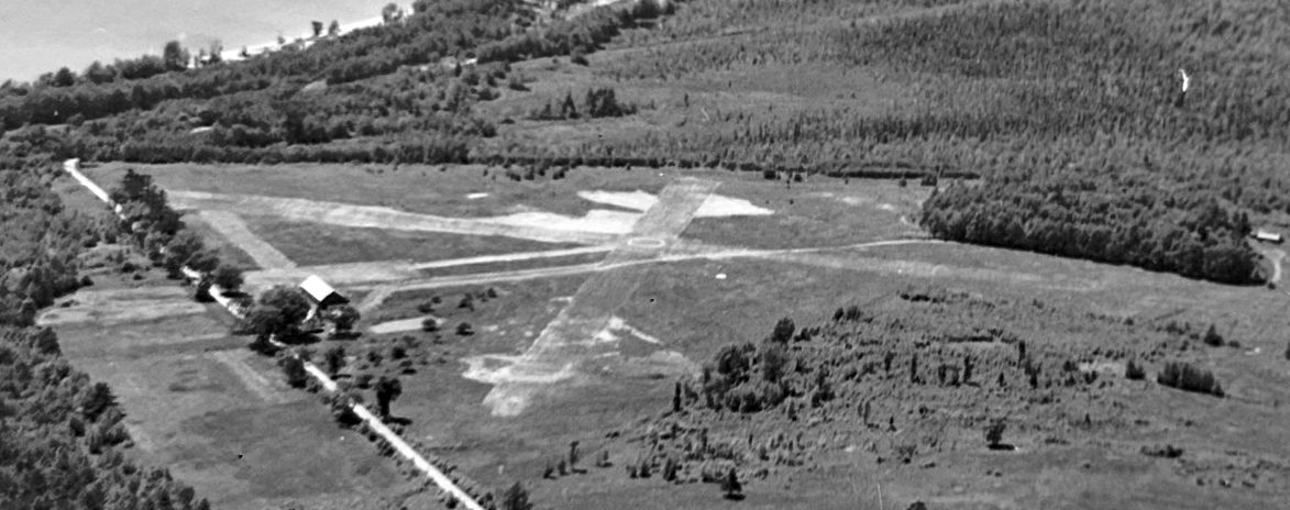
An undated aerial view looking south showing several light aircraft parked near the hangars on Champlain Airport's south side.
Bette Fineman remembered her days at the Champlain Airport:
“I kept my Tiger Moth there... The airport manager Charlie Brink & his wife Virginia
were quite the characters & I knew them between 1978 & whenever the town closed the airport in favor of the park.
The old wood hangar was full of bats as I recall, and in the spring, Charlie sprayed bad stuff at the back & another fellow stood in the open door with 2 tennis racquets,
a grisly but interesting & effective operation.
Both runways were used... I used [the smaller crosswind runway] myself one day when the wind came up & my biplane needed to land pretty directly into it.
That day I was flying rides to benefit the EAA chapter scholarship program & raised over $500 in biplane rides by myself.
One of the rides I gave was to Gracie Pugh, who was over 70 at the time (about 1979 I think that was).
She & her husband started Burlington Airport in the 1920s & Gracie was the first licensed woman pilot in Vermont.
After her flight in the Tiger Moth, she was in tears.”
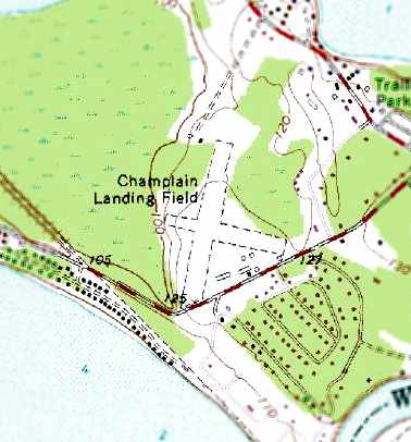
The 1972 USGS topo map depicted “Champlain Landing Field” as having 2 unpaved runways, with several buildings (hangars?) along the south side of the field.
Mitch Loiselle recalled, “Champlain was a great little airport back in its heyday!
I learned to fly off grass there, back in 1975 with a friend’s Cessna 150.”
A circa late-1970s picture of Jon Fineman in his homebuilt “Flybaby” ready for takeoff at Champlain Airport (courtesy of William Schwittek).
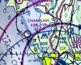
The 1983 Montreal Sectional Chart (courtesy of Jonathan Westerling) depicted Champlain as having a 1,900' unpaved runway.
According to the Vermont Historical Society website, “A rare F2 tornado hit Colchester on 8/8/83.
The storm capsized aircraft at the Champlain Airport & snapped trees 100 feet tall.”
Champlain Airport was evidently closed (presumably due to the storm damage) at some point between 1983-84,
as it was no longer depicted on the September 1984 Montreal Sectional Chart,
nor listed in the 1988 AOPA Airport Directory (according to Jonathan Westerling).
A circa late-1980s aerial view of the site of Champlain Airport by Joseph Melanson of www.skypic.com.
According to Jonathan Westerling, “By the early 1990s the airport had been converted into a park with baseball diamonds, and tennis courts.
Unfortunately for the community & the people that flew there, other than its name 'Airport Park',
there are no other references or plaques commemorating the colorful aviation happenings that occurred there over prior decades.”
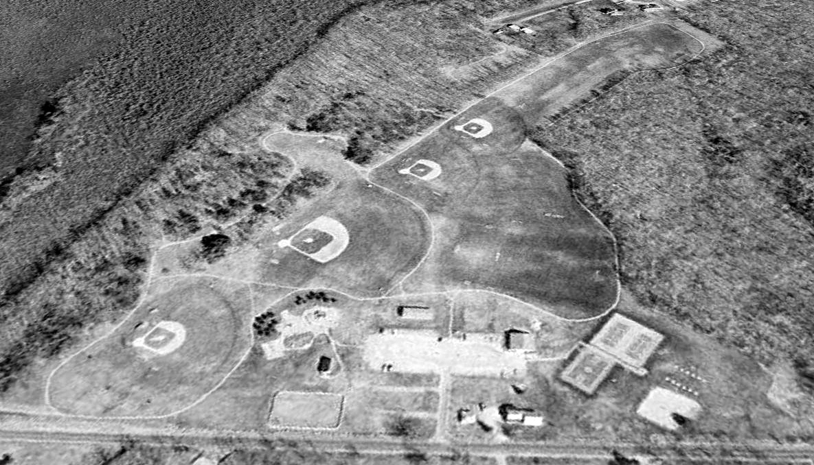
A 1999 USGS aerial view looking northwest showed that the Champlain Airport site had been converted into Airport Park, with the former airfield being converted into baseball fields,
but the north runway end remained clear (at top-right), and at least one of the buildings along the southeast side of the property remained from its airport days.
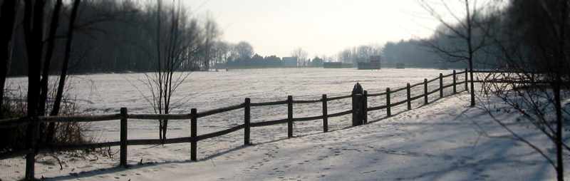
A nice January 2006 photo by Jonathan Westerling of the snow-covered scene looking south along what used to be Champlain's Runway 20.
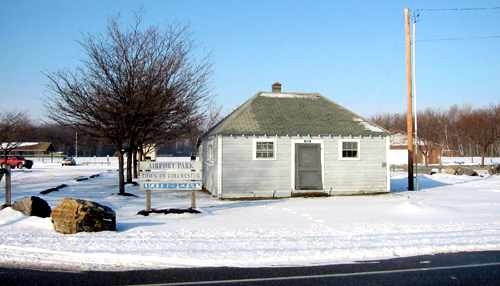
A January 2006 photo by Jonathan Westerling of the entrance to “Airport Park”, showing the former Champlain Airport office building.
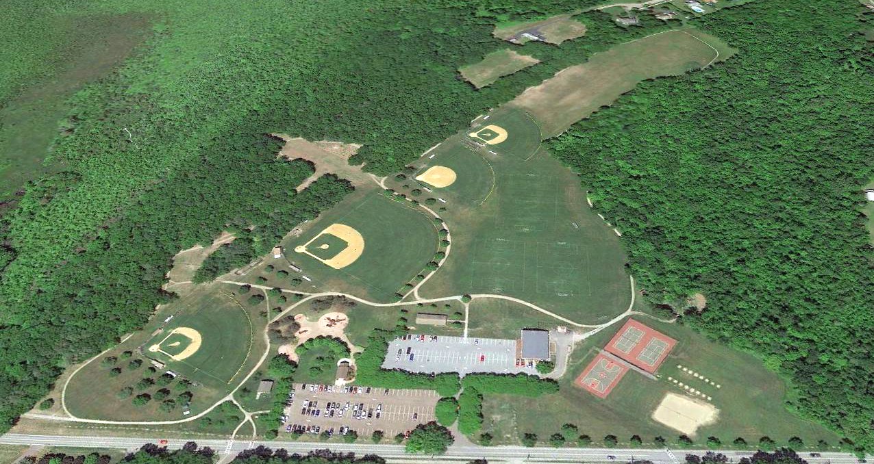
A 2018 aerial view looking northwest at the Champlain Airport site, showing the majority occupied by baseball fields, but the north runway end remaining clear (top-right).
The site of Champlain Airport is located west of the intersection of Colchester Point Road & Pine Meadow Drive.
Thanks to Jonathan Westerling for pointing out this airfield.
____________________________________________________
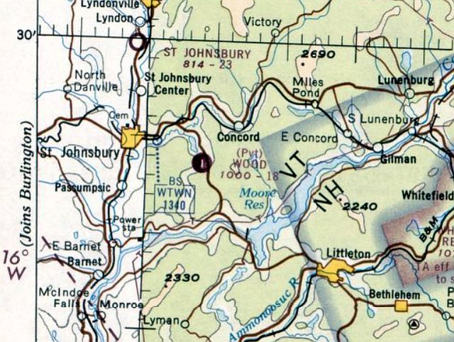
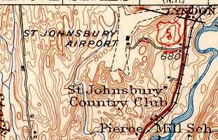
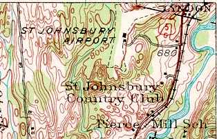
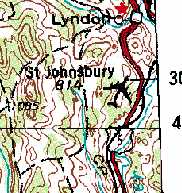
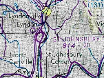
Brown Airport / St. Johnsbury Airport, Lyndonville, VT
44.497, -72.012 (Northwest of Boston, MA)
St. Johnsbury Municipal Airport, as depicted on the September 1936 Burlington Sectional Chart (courtesy of Chris Kennedy).
The date of construction of this small general aviation airport has not been determined.
The earliest depiction which has been located of St. Johnsbury Municipal Airport was on the September 1936 Burlington Sectional Chart.
The Airport Directory Company's 1937 Airports Directory (courtesy of Bob Rambo)
described the St. Johnsbury Municipal Airport as being located 4 miles north of the town.
The field was said to have 2 sod runways: a 2,000' north/south strip & a 1,700' east/west strip, and the field was said to have a hangar.
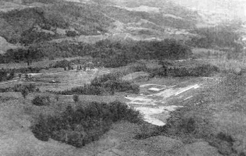
An aerial view looking southeast at the St. Johnsbury Municipal Airport
from the Airport Directory Company's 1941 Airport Directory (courtesy of Chris Kennedy).
The directory described St. Johnsbury Municipal Airport as having 2 sod runways: 2,500' north/south & 1,700' east/west.
The field was said to have a hangar.
“Brown” Airport was depicted as a commercial/municipal airport on the August 1942 Burlington Sectional Chart (courtesy of Chris Kennedy).
A 9/1/42 USGS aerial photo depicted St. Johnsbury Airport as having 2 unpaved runways, with a small hangar to the southeast of the runway intersection.
St. Johnsbury Airport, as depicted on the 1943 USGS topo map.
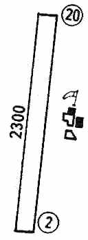
The April 1944 US Army/Navy Directory of Airfields (courtesy of Ken Mercer)
described St. Johnsbury's "Brown" Airport as having a 2,300' unpaved runway.
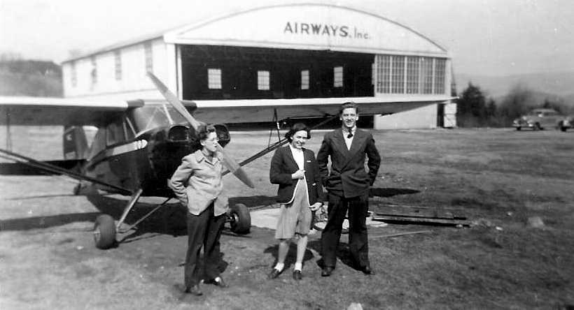
A 1945 photo (courtesy of Chris Landy) of his father (Frank Landry) in front of a taildragger & an “Airways Inc” hangar at the St. Johnsbury Airport.
Chris reported, “My Dad would have been 18 at the time.
He said a bunch of them went to the airport to meet a pilot there - someone they knew, I think - but did not go flying.”
A 1947 aerial photo depicted the St. Johnsbury Airport as having 2 unpaved runways, with a hangar southeast of the runway intersection.
St. Johnsbury Airport, as depicted on the 1949 USGS topo map.
The 1957 VT Airport Directory (courtesy of Jonathan Westerling) described St. Johnsbury Airport as having 2 turf runways (2,300' north/south & 1,800' east/west),
operated by Caledonia Airways, and managed by Carl Remick.
The 1962 AOPA Airport Directory described St. Johnsbury Municipal Airport
as having 2 turf runways: 2,300' Runway 18/36 & a 1,500' crosswind runway.
The field was said to offer fuel, repairs, hangars, and tiedowns, and the operator was listed as Northeast Flying, Inc.
The November 1966 Lewiston Sectional Chart depicted St. Johnsbury Airport as having a 2,300' unpaved runway.
The St. Johnsbury Airport was still depicted on the 1972 USGS topo map
(and depicted with a symbol of a 4-engine swept-wing aircraft, which is quite ironic for such a tiny grass airfield).
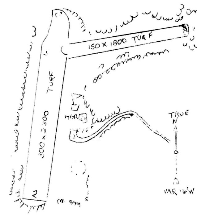
The 1972 Flight Guide (courtesy of Chris Kennedy) depicted St. Johnsbury Municipal
as having a single 2,300' Runway 2/20, with a cluster of buildings (hangars?) east of the runway.
The 1976 AOPA Airports USA directory (according to Chris Kennedy) listed Saint Johnsbury Municipal as having a single 2,300 turf Runway.
"St. Johnsbury" was depicted on the April 1978 Montreal Sectional Chart (courtesy of Chris Kennedy)
as having a 2,000' unpaved runway.
The St. Johnsbury Airport was evidently closed (for reasons unknown) within the next year,
as it was no longer listed in the 1979 Flight Guide (according to Chris Kennedy).
By the time of the 1983 USGS topo map, the St. Johnsbury Airport itself was no longer depicted,
although the distinctly-shaped clearing for the 2 former runways was still depicted.
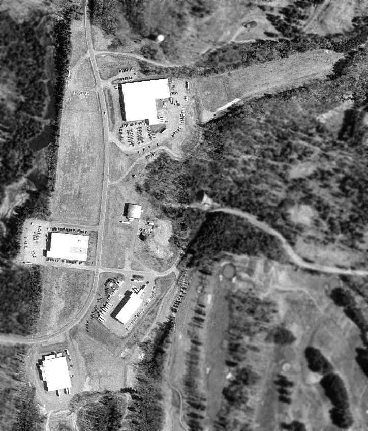
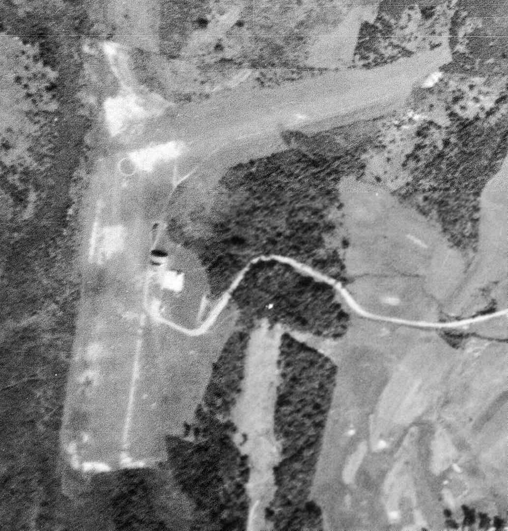
As seen in the 1999 USGS aerial photo, the clearing of the 2 former grass runways was still quite recognizable,
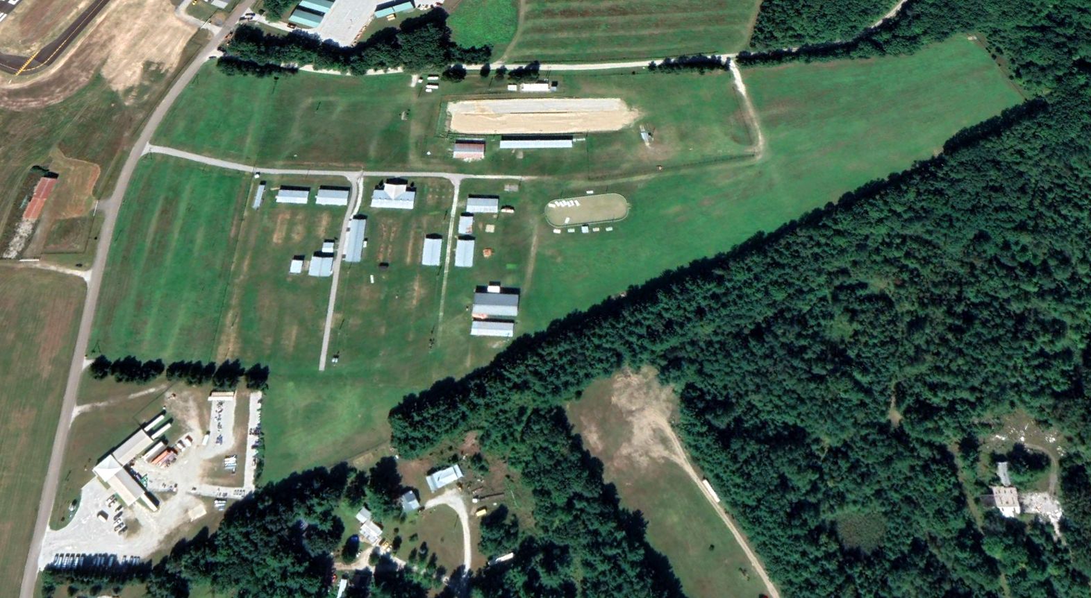
but several large industrial buildings have been constructed over portions of the former runways.
According to Mitch Fournier, "My faded memories tell me that the curved-roofed building in the middle of the image might be the old hangar."
The former St. Johnsbury Airport hangar was evidently removed at some point between 1999-2006,
as a 2006 aerial photo showed that it had been replaced by an industrial building, removing the last trace of the airport.
The site of St. Johnsbury Airport is located west of the intersection of Route 5 & Airport Road,
appropriately enough.
____________________________________________________
Fort Ethan Allen AAF, Burlington, VT
44.504, -73.162 (Northwest of Boston, MA)
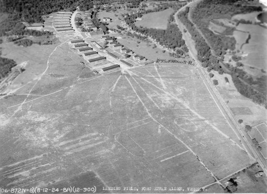
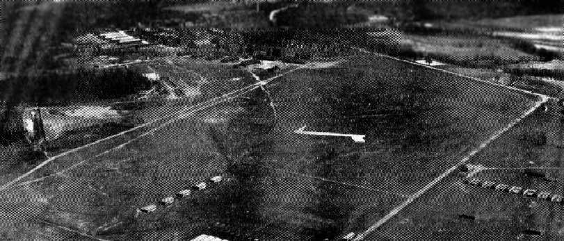
An 8/12/24 aerial view of Fort Ethan Allen AAF (courtesy of Terry Goggin).
The date of construction of this small military airfield is unknown.
Fort Ethan Allen itself was established in 1892, on land once owned by Revolutionary War hero Ethan Allen.
The Fort served as an artillery training base during WW2.
The earliest depiction of Fort Ethan Allen Airfield which has been located was an 8/12/1924 aerial view (courtesy of Terry Goggin).
According to Russ Chmela, a VT PBS documentary in the 1980s said that "the flying field at Ethan Allen was only used during the 1920s & 1930s,
for operating biplanes (types were not given on the program, but they looked like Curtiss Jennies & similar rickety craft).
The highlight of this field's use was during the great flood of 1927
when the aircraft based at Ethan Allen were used to search for missing people lost in the disaster & for aerial photo recon of the flooded areas,
since the areas affected had poor roads leading to them."
According to Brian Lindner, Vermont's first fatal military aircraft crash occurred after a takeoff from Ethan Allen on11/14/27.
“They crashed in Montpelier soon thereafter & Herbert Hoover's personal assistant was killed.
The plane was a U.S. Army PT-1 #27-157. They were attempting to land at the Montpelier Landing Field.”
The 1929 "Rand McNally Standard Map of VT with Air Trails" (courtesy of Chris Kennedy)
depicted Fort Ethan Allen as an auxiliary airfield, measuring 1,800' x 1,500'.
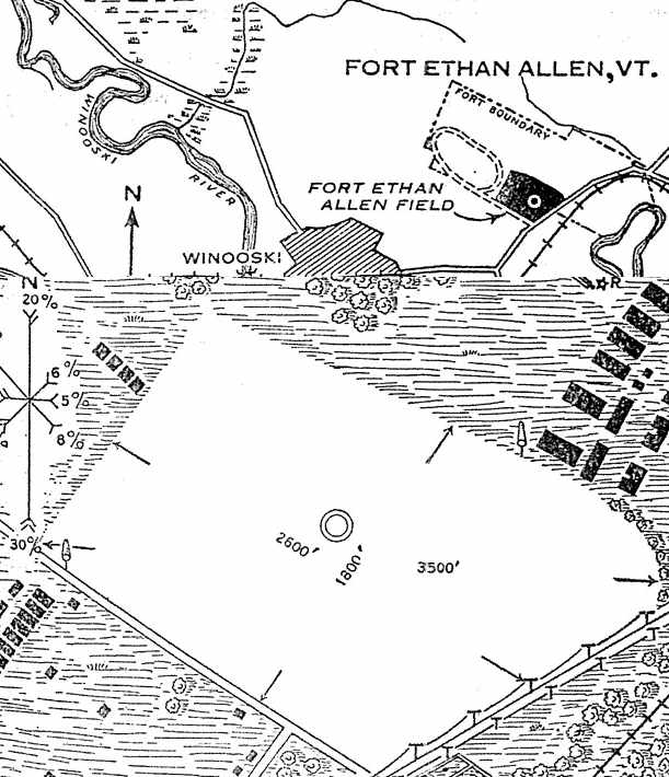
The location & layout of Ft. Ethan Allen Field, as depicted on the 6/3/1930 Department of Commerce Airway Bulletin (courtesy of Jonathan Westerling).
The field was described as consisting of a 67.5 acre rectangular sod field, without any hangars or other buildings directly associated with the airfield.
The earliest aeronautical chart depiction which has been located of Fort Ethan Allen Airfield was on the June 1936 Burlington Sectional Chart.
The 1936 Department of Commerce Airfield Directory (courtesy of Jonathan Westerling)
described “Fort Ethan Allen Field, Army” as consisting of a rectangular sod field, measuring 2,600' x 1,800'.
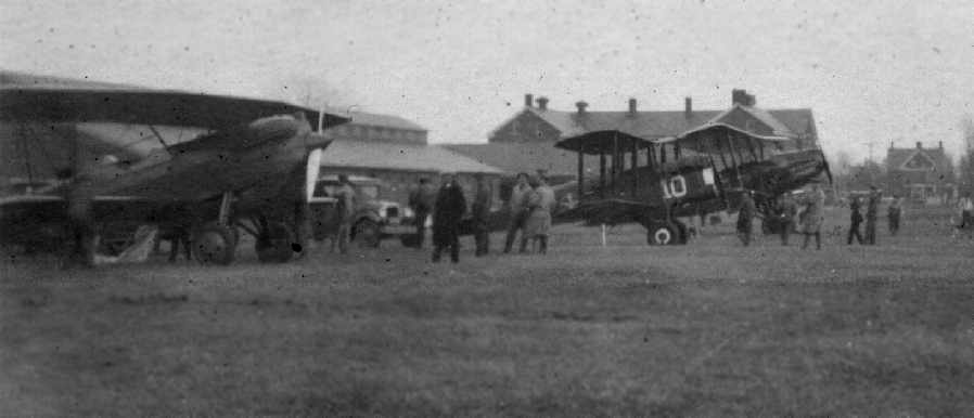
An undated view (circa 1930s?) of several unidentified biplanes at Fort Ethan Allen AAF(courtesy of Shirley Bergeron).
An aerial view looking east at Fort Ethan Allen AAF from The Airport Directory Company's 1937 Airports Directory (courtesy of Bob Rambo).
The directory described Fort Ethan Allen AAF as consisting of a 2,600' x 1,800' sod landing area.
The aerial photo in the directory depicted a row of five hangars on the northwest portion of the field.
According to Russ Chmela, "All routine flying at Ethan Allen was finished before the 1940s."
Although it have been mostly inactive,
Fort Ethan Allen Army Airfield was still depicted on the 1942 Burlington Sectional Chart (courtesy of Chris Kennedy).
According to a history of Fort Ethan Allen, the Fort was declared inactive in 1944,
and was subsequently used as a storage depot for equipment.
USGS topo map 1948.
Forth Ethan Allen was reused as after WW2 by the National Guard.
The airfield was depicted on the 1948 Burlington Sectional Chart (according to Chris Kennedy) as "Ft. Ethan Allen (NG)",
and described as having a 2,400' unpaved runway.
Strangely, "Ft. Ethan Allen (Army)" was depicted as an active airfield on the 1951 Burlington Sectional Chart (according to Chris Kennedy),
yet the remarks in the Aerodromes table on the chart said "Closed".
The field was described as consisting of a single 3,000' unpaved runway.
The last aeronautical chart depiction which has been located of Fort Ethan Allen AFB was on the May 1954 Burlington Sectional Chart.
It depicted Ft Ethan Allen AFB as having a 3,000' unpaved runway.
Fort Ethan Allen AFB was evidently closed at some point between 1954-55,
as it was no longer depicted on the May 1955 Burlington Sectional Chart.
Saint Michael's College & the University of Vermont signed a contract in 1964
which gave them ownership to designated areas of the former Fort Ethan Allen base for educational purposes.
An 8/11/72 USGS aerial photo showed Ft. Ethan Allen's paved ramp still existed, and the grass runway area was still largely clear.
Russ lived near Fort Ethan Allen from 1980-95, and reported that "I passed Ethan Allen many times a week
and did often see helicopters there, mostly UH-1s, Kiowas [OH-58s] and Loaches [OH-6s]."
The site of Fort Ethan Allen AAF was still labeled "Camp Johnson (Nat Guard)" on the 1981 USGS topo map.
The paved ramp of the airfield was still depicted on the 1987 USGS topo map.
However, the Fort Ethan Allen airfield was no longer depicted at all (even as an abandoned airfield) on 1998 aeronautical charts.
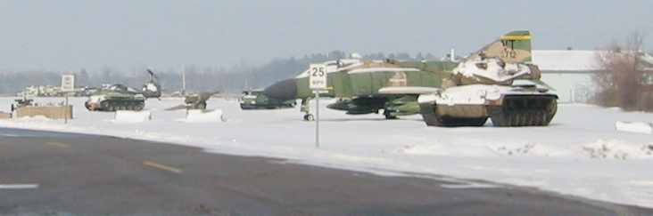
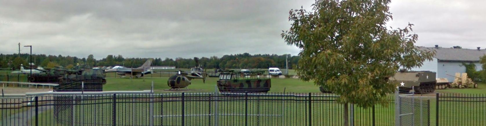
A January 2006 photo by Jonathan Westerling of an F-4 Phantom, UH-1 Huey,
and several tanks just within the entrance to Camp Johnson (as the Ft Ethan Allen airfield site is now known).
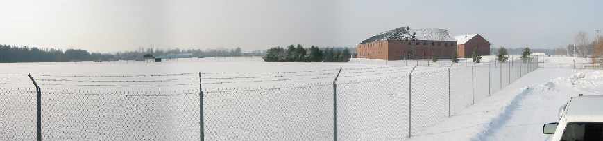
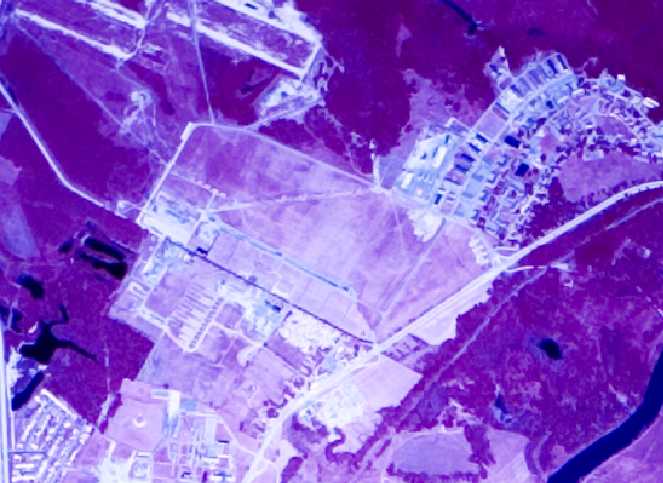
A January 2006 panorama by Jonathan Westerling taken from the northeast corner of the former airfield area at Ft Ethan Allen showed that it remained relatively clear.
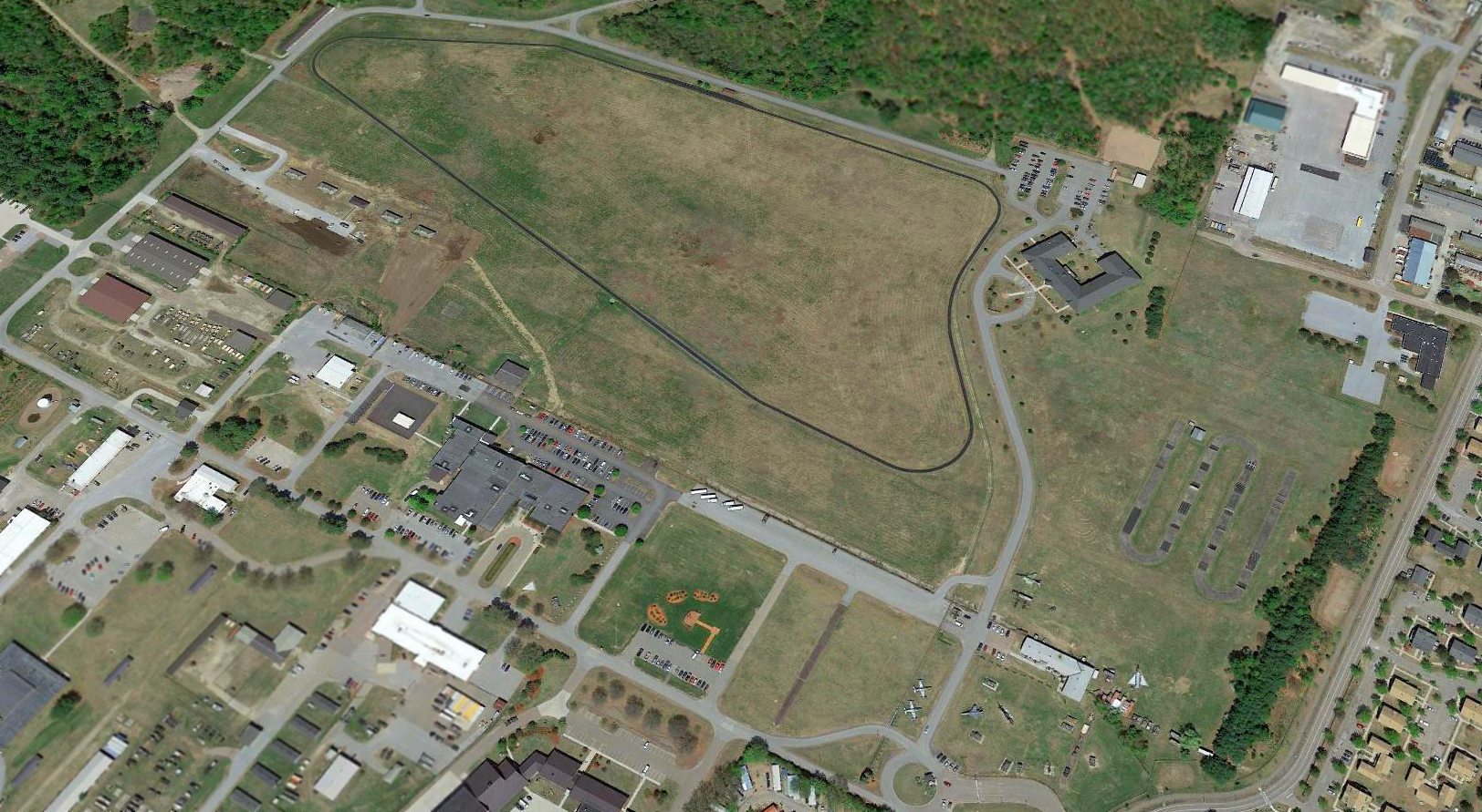
A 2015 aerial view looking north showed the Ft. Ethan Allen AAF paved ramp still existed, and the grass runway area was still largely clear.
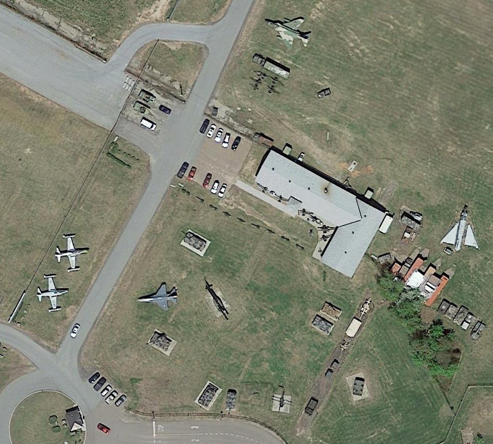
A 2015 aerial view of the static display aircraft at the Ft. Ethan Allen AAF entrance gate,
including an F-4 Phantom, UH-1 Huey, 2 T-33 Shooting Stars, F-16 Fighting Falcon, OH-6 Cayuse, and what appears to be a partially disassembled F-102 Delta Dagger.
A 2018 photo looking northwest at the static display aircraft at the Ft. Ethan Allen AAF entrance gate, now the VT National Guard Library & Museum.
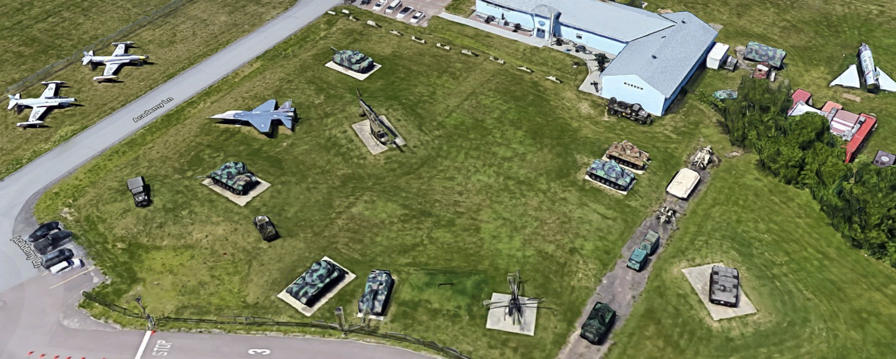
A 2022 3-D aerial image looking north at the static display aircraft at the Ft. Ethan Allen AAF entrance gate, now the VT National Guard Library & Museum.
The site of Fort Ethan Allen AAF is located north of the intersection of Hercules Drive & Academy Lane.
Thanks to Chris Kennedy for pointing out this airfield.
____________________________________________________
Or if you prefer to contact me directly concerning a contribution (for a mailing address to send a check),
please contact me at: paulandterryfreeman@gmail.com
If you enjoy this web site, please support it with a financial contribution.
____________________________________________________
This site covers airfields in all 50 states.