Abandoned & Little-Known Airfields:
© 2002, © 2026 by Paul Freeman. Revised 5/17/26.
This site covers airfields in all 50 states: Click here for the site's main menu.
____________________________________________________
Please consider a financial contribution to support the continued growth & operation of this site.
Campbell Airport (1st location) (revised 11/15/25) - Campbell Airport (2nd location) / Pittsburgh Metro Airport (revised 8/16/19)
Conway Airport / Conway-Pittsburgh (revised 11/7/20) - Greensburg Airport / Pittsburg-Greensburg Airport (revised 5/21/21)
Pittsburgh-McKeesport Airport / Bettis Field / Curtiss-Bettis Airport (revised 11/18/24) - Rock Airport / Pittsburgh Northeast Airport (added 8/8/25)
Wilkinsburg-Pittsburgh Airport / Pittsburgh-Monroeville Airport / Harold Brown Memorial Field (revised 5/17/26)
____________________________________________________
Wilkinsburg-Pittsburgh Airport / Pittsburgh-Monroeville Airport / Harold Brown Memorial Field (4G0/15PA), Monroeville, PA
40.453, -79.775 (East of Pittsburgh, PA)
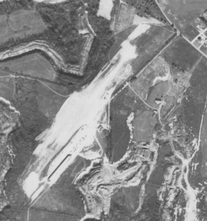
Wilkinsburg-Pittsburgh Airport, as depicted on a 10/27/49 aerial view (from Penn Pilot).
According to its FAA Airport/Facility Directory data, this small general aviation airport east of Pittsburgh was activated in April 1947.
A 1948 aerial view appeared to show Wilkinsburg-Pittsburgh Airport as under construction, with a northeast/southwest-oriented area having been cleared.
According to Wikipedia, Harold & Helen Brown opened Pittsburgh–Monroeville Airport in 1948, and handled the air mail for the Wilmerding Post Office.
However, the airport was not yet depicted on the 1949 Cleveland Sectional Chart.
The earliest depiction which has been located of Wilkinsburg-Pittsburgh Airport was on a 10/27/49 aerial view (from Penn Pilot).
It depicted a northeast/southwest unpaved runway, with 2 long hangars on the south side, and over a dozen light aircraft.
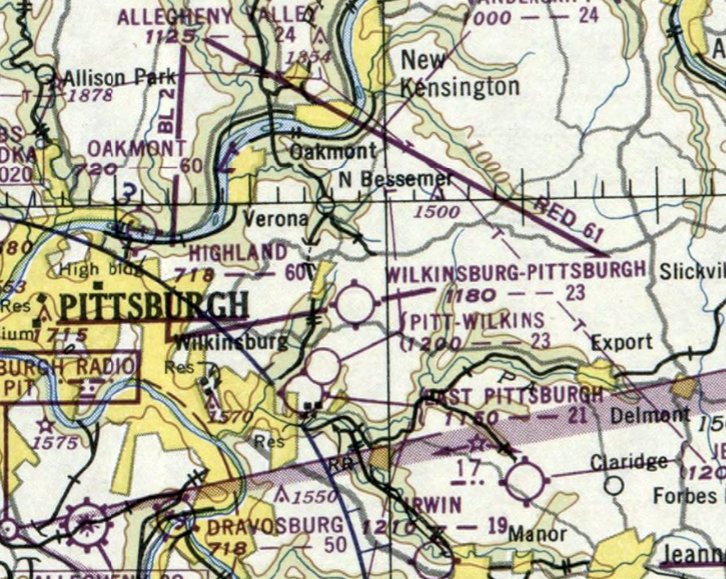
The earliest aeronautical chart depiction which has been located of Wilkinsburg-Pittsburgh Airport was on the June 1950 Cleveland Sectional Chart.
It depicted Wilkinsburg-Pittsburgh Airport as having a 2,300' unpaved runway.
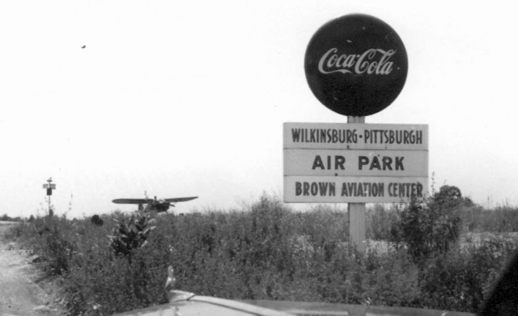
A circa 1950 photo of a sign for Wilkinsburg-Pittsburgh Airport's Brown Aviation Center(courtesy of Jon Ostlund), with a light single-engine taildragger visible in the background.
A 1952 aerial view depicted Wilkinsburg-Pittsburgh Airport as having a northeast/southwest unpaved runway, with 2 long hangars on the southeast side, and 1 light single-engine aircraft.
According to Wikipedia, Pittsburgh–Monroeville Airport had 112 based aircraft between 1952-58.
Tom Imrich recalled, “I used to fly to Monroeville Airport often as a teen, out of Latrobe, Mt. Pleasant, or New Alexandria.
Ralph Tait had his Twin Cessna (WWII era T-50 Bobcat), and later his WW2 surplus Douglas B-26 based there for a bit.
What's not evident in pictures or any FAA description of the airfield, was that the runway had a significant bow in the middle;
it was laterally directionally bent in the middle, with a significant change of direction.
That always made for interesting operations, especially with Ralph's B-26!”
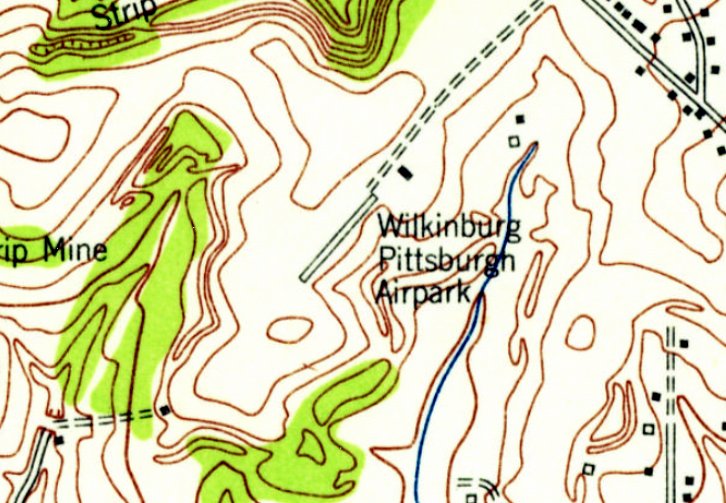
The earliest topo map depiction which has been located of Wilkinsburg-Pittsburgh Airport was on the 1953 USGS topo map.
It depicted Wilkinsburg-Pittsburgh Airport as a northeast/southwest-oriented clearing, but no specific runway was depicted.
One long northeast/southwest-oriented building was depicted on the southeast side, along with a smaller building.
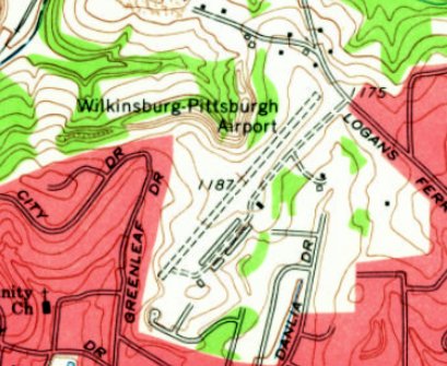
The 1960 USGS topo map depicted Wilkinsburg-Pittsburgh Airport as having a northeast/southwest unpaved runway.
Three additional buildings had been added at some point between 1953-60.
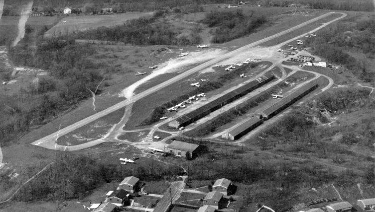
A 1969 aerial view looking north (courtesy of Jon Ostlund) showed that at Wilkinsburg-Pittsburgh Airport had gained a paved runway at some point between 1960-69.
Three rows of hangars sat southwest of the runway, and over 2-dozen light aircraft were visible parked outside.
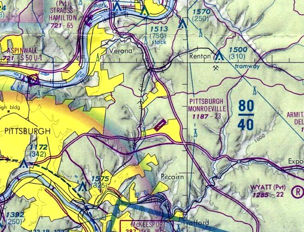
At some point between 1960-73, the airport was renamed Pittsburgh-Monroeville Airport, as that is how it was labeled on the 1973 Pittsburgh Terminal Chart.
It depicted the field as having a 2,300' paved runway.
Bill Rose recalled, “Pittsburgh-Monroeville was where my interest in flying began.
My dad would take my brother & I there to watch the planes come & go.
He was friends with the airport's owner, and we had many offers to go flying.
Surprisingly, as keen as I was on the idea, I could never work up the nerve when the opportunity was there.”
According to former manager Ray Wible, at one point Pittsburgh-Monroeville Airport conducted 2,000 takeoffs or landings per year.
Pilots paid $3 for an overnight stay (on the honor system) to defray the expenses of mowing the grass & maintaining the runway.
The airport hosted a gathering every other year for the Aero Club of Pittsburgh.
The airport buildings also served as the meeting place for the Civil Air Patrol's Cadet Squadron 604.
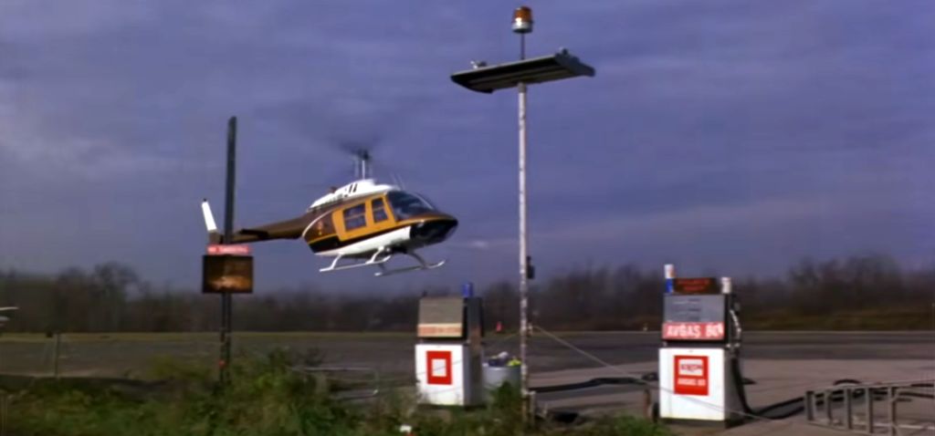
A still from the 1978 cinematic masterpiece “Dawn of the Dead” (courtesy of Matt Franklin) of a Bell JetRanger landing at Pittsburgh-Monroeville Airport fuel pumps.
In 1982 an exterior set of Jordy Verrill's space-grass-covered farmhouse was constructed on a grassy slope behind Pittsburgh-Monroeville Airport's main runway for the 1982 George Romero / Stephen King film “Creepshow”.

A 1993 aerial view looking northwest showed Pittsburgh-Monroeville Airport devoid of aircraft.
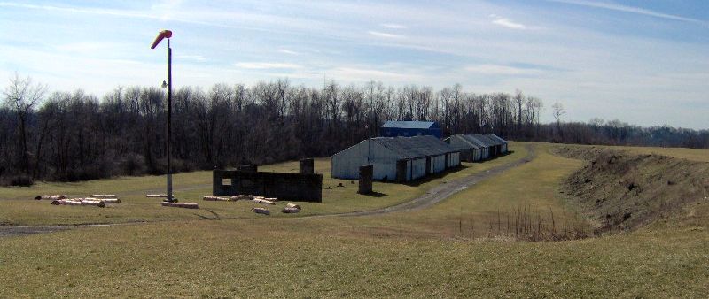
A 2005 photo of Pittsburgh-Monroeville Airport's hangars (courtesy of Jon Ostlund).
Bill Rose reported in 2006, “Pittsburgh-Monroeville Airport has been in decline for many years,
being located within an area that is now densely populated & over-developed with shopping centers.
It has closed for short periods over the last decade due to the condition of the runway & has a rather treacherous reputation with local pilots
(though not entirely earned since most, when questioned, have never put the gear on the runway).
I know the man who manages the field for the owner's widow.”
According to FAA Airport/Facility Directory data, Pittsburgh-Monroeville Airport consisted of 63 acres.
For the year ending 6/12/07, Pittsburgh-Monroeville Airport conducted 5,709 takeoffs or landings, and had 17 based aircraft.
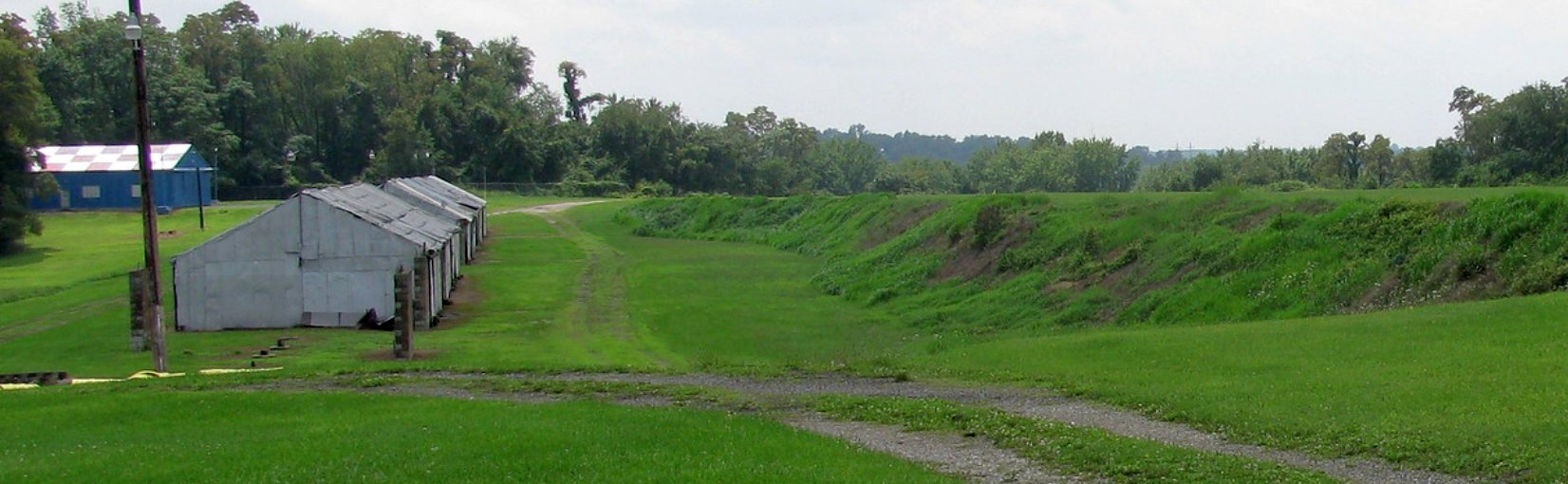
A 7/28/12 photo looking south at Pittsburgh-Monroeville Airport's hangars, with the runway to the right.
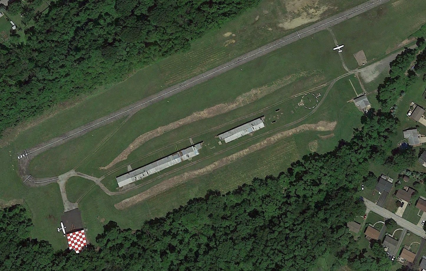
The last photo which has been located showing planes at Pittsburgh-Monroeville Airport was a 2014 aerial view looking northwest.
Two light single-engine planes were seen, 1 parked near the checkerboard-roofed hangar on the south side, and another on the midfield taxiway, perhaps on its way to the runway.
Dave
Weiss reported in 2015, “Monroeville Airport is still in
existence but not used.”
According to Wikipedia, In 2021, Monroeville Airport's office building was severely damaged when vandals lit a fire inside.
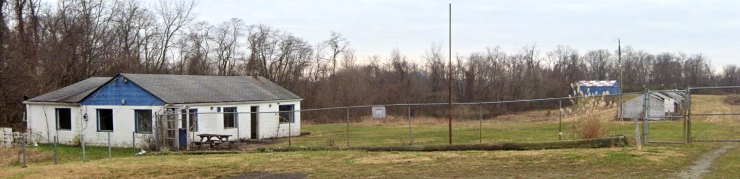
A sad November 2022 photo looking south showed Pittsburgh-Monroeville Airport's office & several hangars.
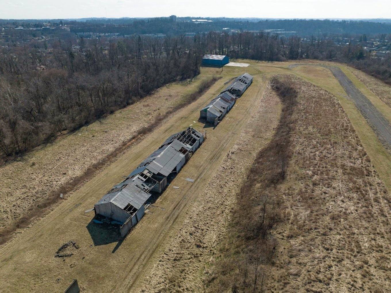
A 2023 aerial view looking south at the long row of Pittsburgh-Monroeville Airport hangars, many with missing roof sections.
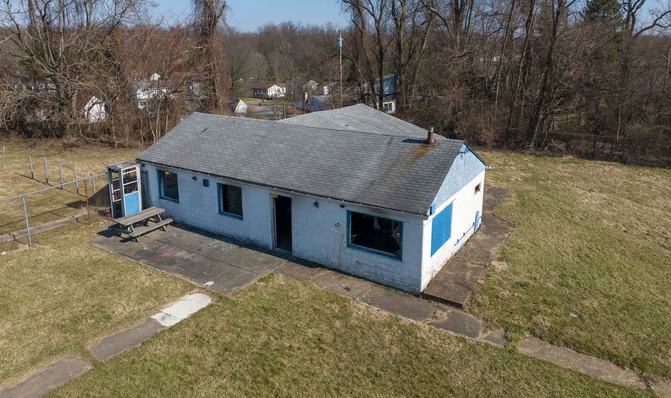
A 2023 photo of Pittsburgh-Monroeville Airport's office.
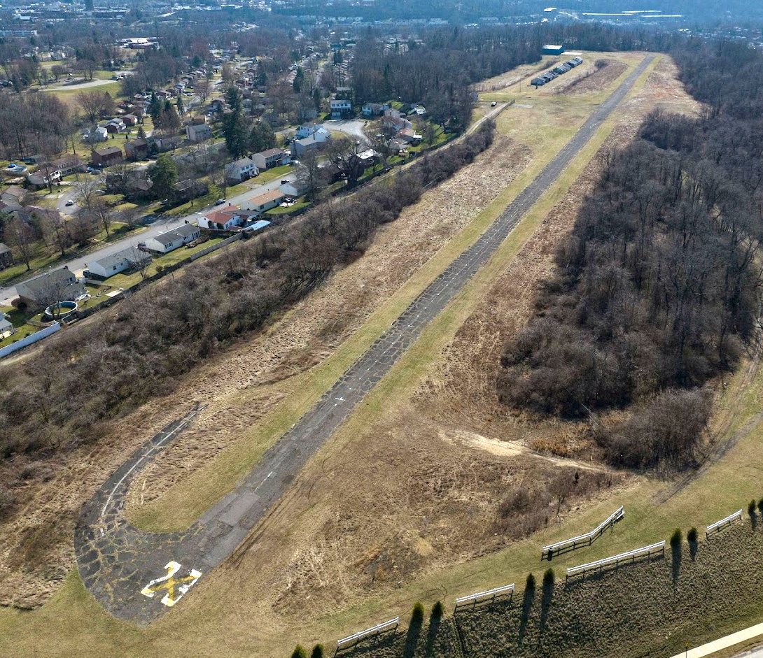
A 2023 aerial view looking south along Pittsburgh-Monroeville Airport's Runway 23.
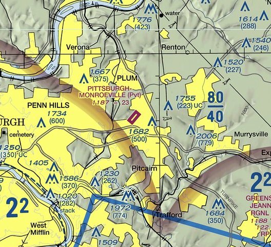
The 2023 Pittsburgh Terminal Chart depicted Pittsburgh-Monroeville Airport as a private field having a 2,300' paved runway.
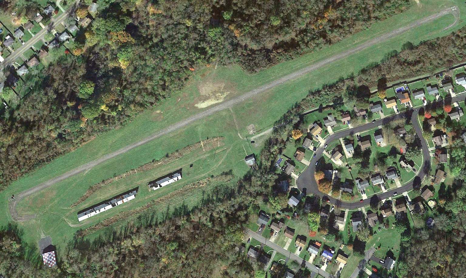
A 2023 aerial view looking northwest showed Pittsburgh-Monroeville Airport as remaining intact though deteriorated.
Ryan Miller reported, “Pittsburgh-Monroeville Airport is slated for closure in FAA records effective 3/23/23.”
Jon Ostlund reported “The airport was permanently closed in 2023.”
According to Wikipedia, in 2023 the airport was sold to Clover Communities Monroeville LLC,
and the airport was razed by CCM – including all hangars, runways, charthouse, and maintenance hangar – to make way for their senior living facility.
As of 2023, street maps labeled the field as Harold Brown Memorial Field, located along Brown's Airport Road, in recognition of the airport's founder.
Jon Ostlund reported in 2025, “Monroeville Airport... all of the hangars [are] removed & the northeast end of the runway has been removed & a new assisted living facility is being built there.
The only building that remains is the farthest-southwest building with the checkerboard roof.”
As of 2026, street maps label the airport site as the location of Logans Ferry Apartments.
Thanks to Ryan Miller for pointing out this airfield.
____________________________________________________
Greensburg Airport / Pittsburg-Greensburg Airport, Greensburg, PA
40.276, -79.512 (East of Pittsburgh, PA)
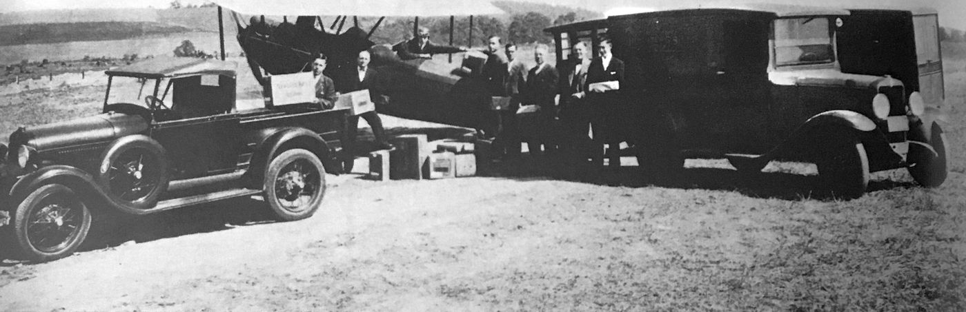
A 9/21/29 photo of Alfred Young posing in the cockpit of his OX5 Challenger after having delivered a shipment of Atwater Kent radios,
the first air freight delivery to the new Pittsburgh-Greensburg Airport (courtesy of Thomas Imrich).
The original airport for the town of Greensburg was located on the southeast side of the town.
The earliest photo which has been located of Pittsburgh-Greensburg Airport was a 9/21/29 photo (courtesy of Thomas Imrich)
of Alfred Young posing in the cockpit of his OX5 Challenger after having delivered a shipment of Atwater Kent radios,
the first air freight delivery to the new airport.
Pittsburgh-Greensburg Airport was not yet depicted on the 1929 USGS topo map (or subsequent topo maps from the 1930s-40s).
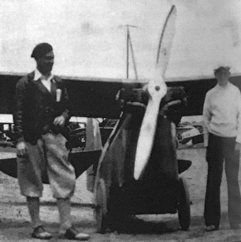
A circa 1920s-30s photo of George Dickson & Frank Fox with an Aeronca OX5 at Pittsburgh-Greensburg Airport (courtesy of Thomas Imrich).

A 1932 photo of Pittsburgh-Greensburg Airport manager Norman “Happy” O'Bryan posing in front of a Main Aviation Ryan, while Dick Copeland reached into the cockpit (courtesy of Thomas Imrich).
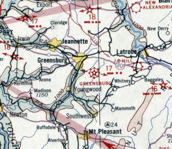
The earliest aeronautical chart depiction which has been located of Greensburg Airport was on the December 1932 Cleveland Sectional Chart.
It depicted Greensburg as a commercial/municipal airport, having CAA Beacon # 17.
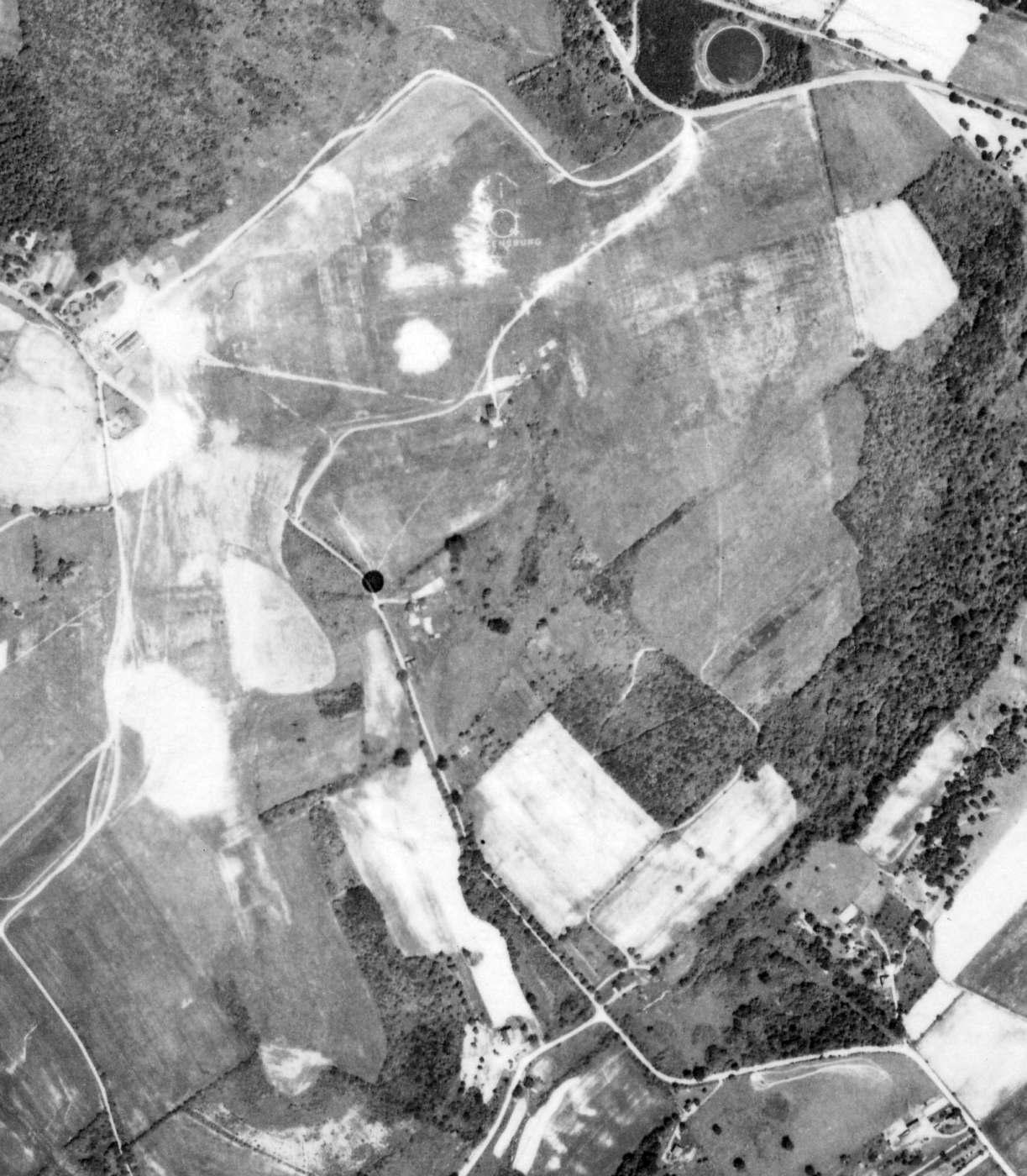
The earliest aerial photo which has been located of Greensburg Airport was a 6/6/39 aerial view.
It depicted Greensburg as having an irregularly-shaped grass airfield,
with an airport circle marking with the name “Greensburg” visible in the center.
A hangar was located on the northwest side, but no aircraft were visible on the field.
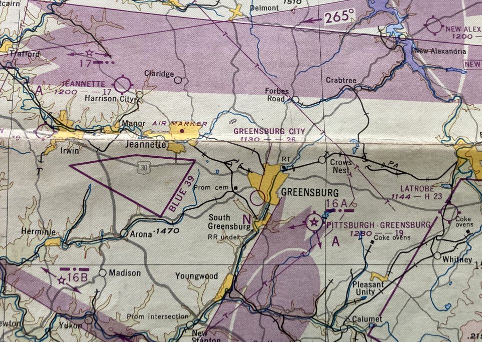
The January 1948 Pittsburgh Local Aeronautical Chart (courtesy of Tom Imrich) depicted Pittsburgh-Greensburg Airport as having a mere 1,900' unpaved runway, but to also have CAA Beacon # 16A.
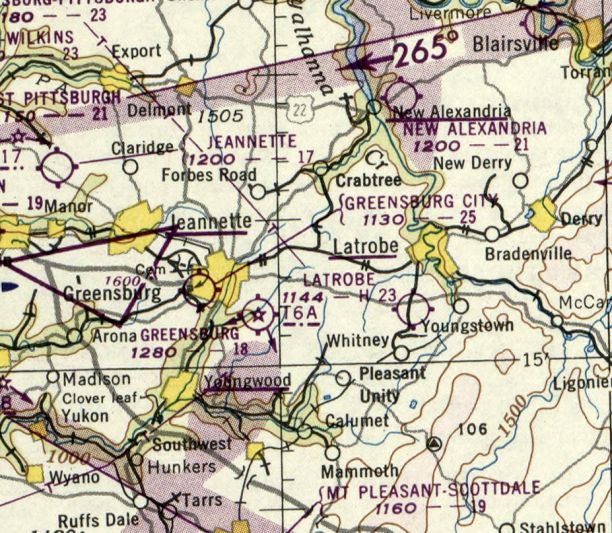
The last aeronautical chart depiction which has been located of Greensburg Airport was on the November 1950 Cleveland Sectional Chart.
It depicted Greensburg as having a mere 1,800' unpaved runway, but to also have CAA Beacon # 16A.
The last photo which has been located showing an aircraft at Greensburg Airport was a 1952 aerial view.
It depicted the airport as having 3 unpaved runways, with a hangar & 1 single-engine light aircraft on the northwest side.
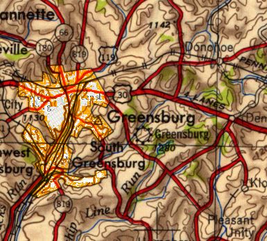
The earliest topo map depiction which has been located of Greensburg Airport was on the 1953 USGS topo map.
Greensburg Airport was evidently closed at some point between 1952-55,
as a 1955 aerial view showed the area of the runways was still clear, but the runway alignments were no longer recognizable.
The hangar remained on the northwest side of the property, but no aircraft were visible.
Ttom Imrich recalled, “Pittsburgh-Greensburg Airport had for a very long time been known to be much to small & too limited in expansion potential
to ever practically serve the evolving airlines, with their new B247s & DC-3s.
It was built on a tiny flat hilltop with steep cliffs at the end of every runway direction.
So that's why it eventually died, when Earl Metzler (its last airport manager) finally closed it down.”
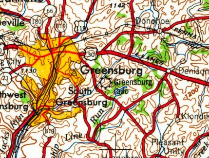
Greensburg Airport was still depicted on the 1959 USGS topo map,
even though it had most likely ceased to operate for at least 4 years by that point.
A 1962 aerial view showed that houses had covered the site of Greensburg Airport,
leaving no trace of the former little airport.
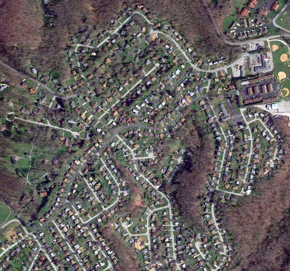
A 2016 aerial view showed that no trace remaining of Greensburg Airport.
The site of Greensburg Airport is located at the intersection of Newport Drive & Old Airport Road, appropriately enough.
Thanks to Thomas Imrich for pointing out this airfield.
____________________________________________________
Rock Airport / Pittsburgh Northeast Airport (9G1), Tarentum, PA
40.604, -79.826 (Northeast of Pittsburgh, PA)
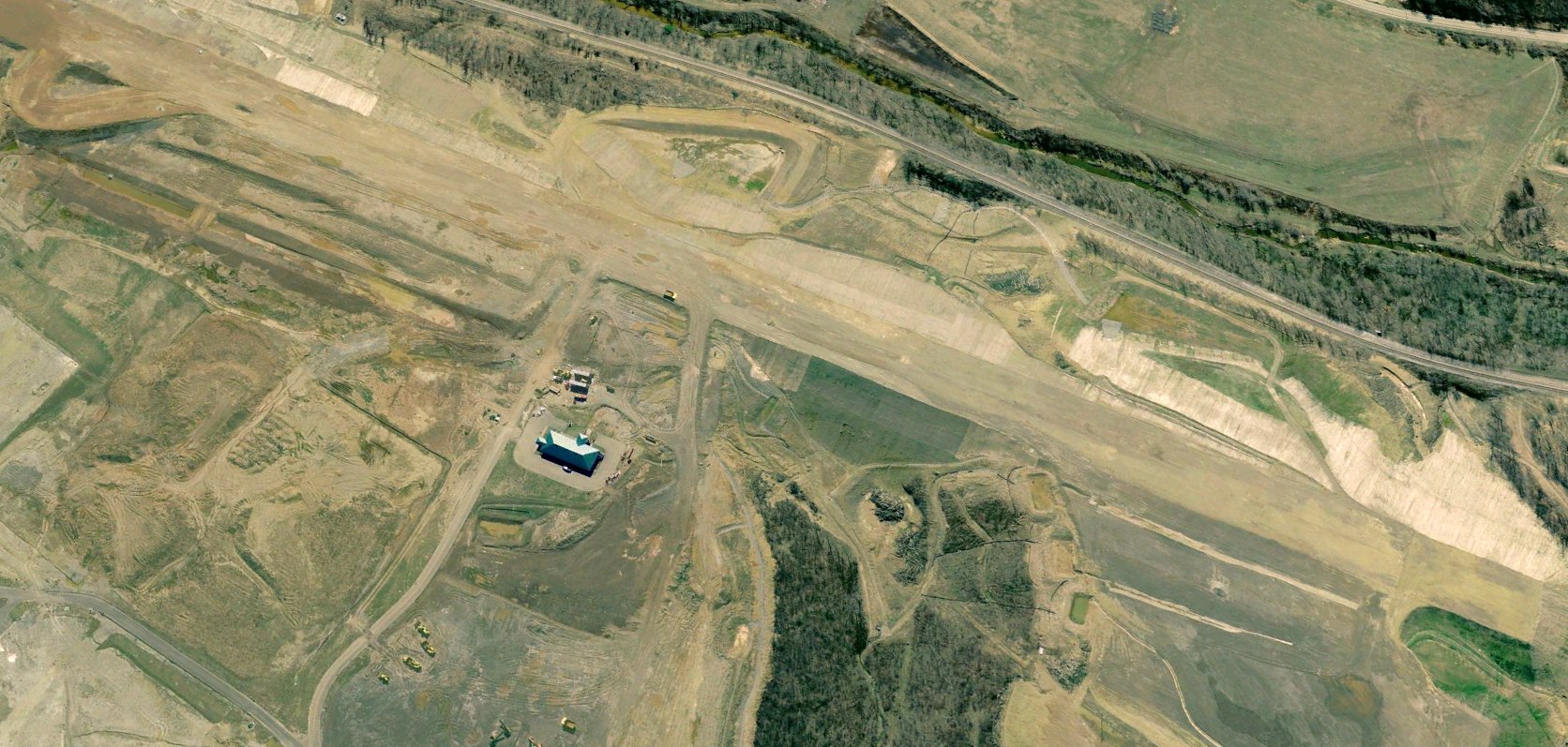
A 2005 aerial view looking southwest showed Rock Airport under construction,
This small general aviation airport was evidently construction at some point between 1993-2004, as it was not yet depicted on a 1993 aerial photo.
A 2004 aerial view showed airport terminal building having been built, and the runway under construction.
It was constructed by local businessman Rock Ferrone, and was immediately adjacent to the former West Penn Airport.
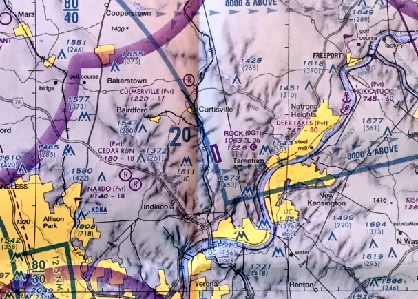
The earliest aeronautical chart depiction which has been located of Rock Airport was on the April 2009 Pittsburgh Terminal Chart.
It depicted Rock as having a single northwest/southeast 3,500' paved runway.
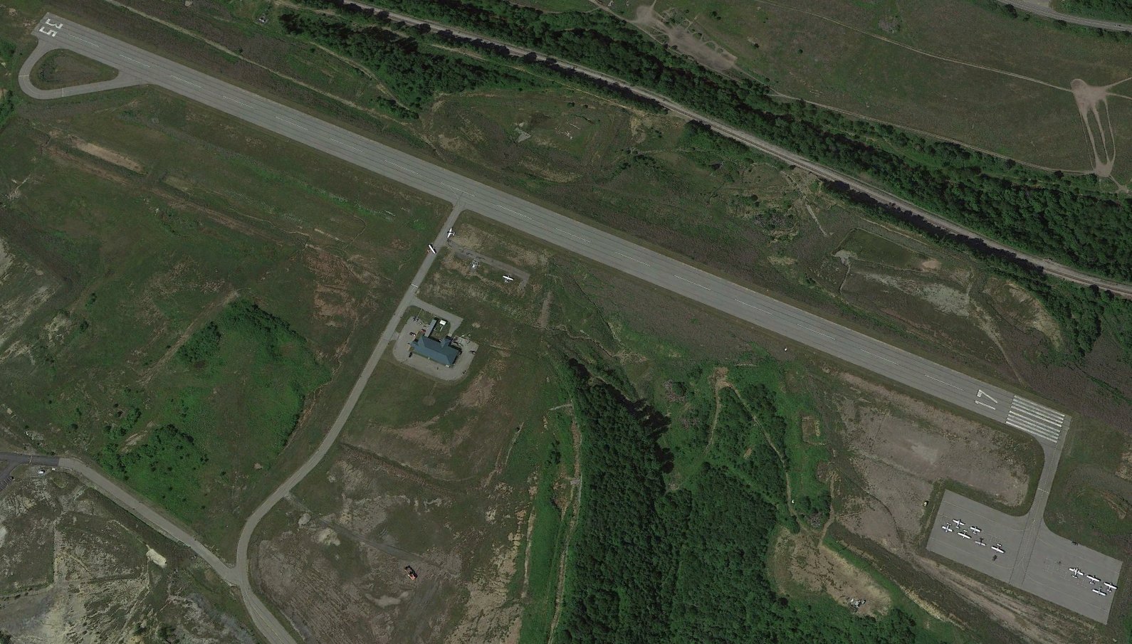
A 2010 aerial view looking southwest depicted Rock Airport perhaps at its zenith of popularity, with a total of 13 light single-engine aircraft visible on its east & northeast ramps.
According to Wikipedia, for the year ending 11/23/11 the airport had an average of 248 takeoffs or landings per month.
At that time there were 20 aircraft based at the airport: 19 single-engine & 1 multi-engine.
According to Jonathan Ostlund, “In 2013 the airport went into bankruptcy & was bought by Alaskan Property Management, with the sale finalized in 2014.”
According to Wikipedia, Pittsburgh Northeast Airport was bought for $9 million in 2014 by Alaskan Property Management, a subsidiary of Management Science Associates.
Pittsburgh Northeast Airport covered an area of 149 acres, and had a single 3,550' asphalt Runway 17/35.
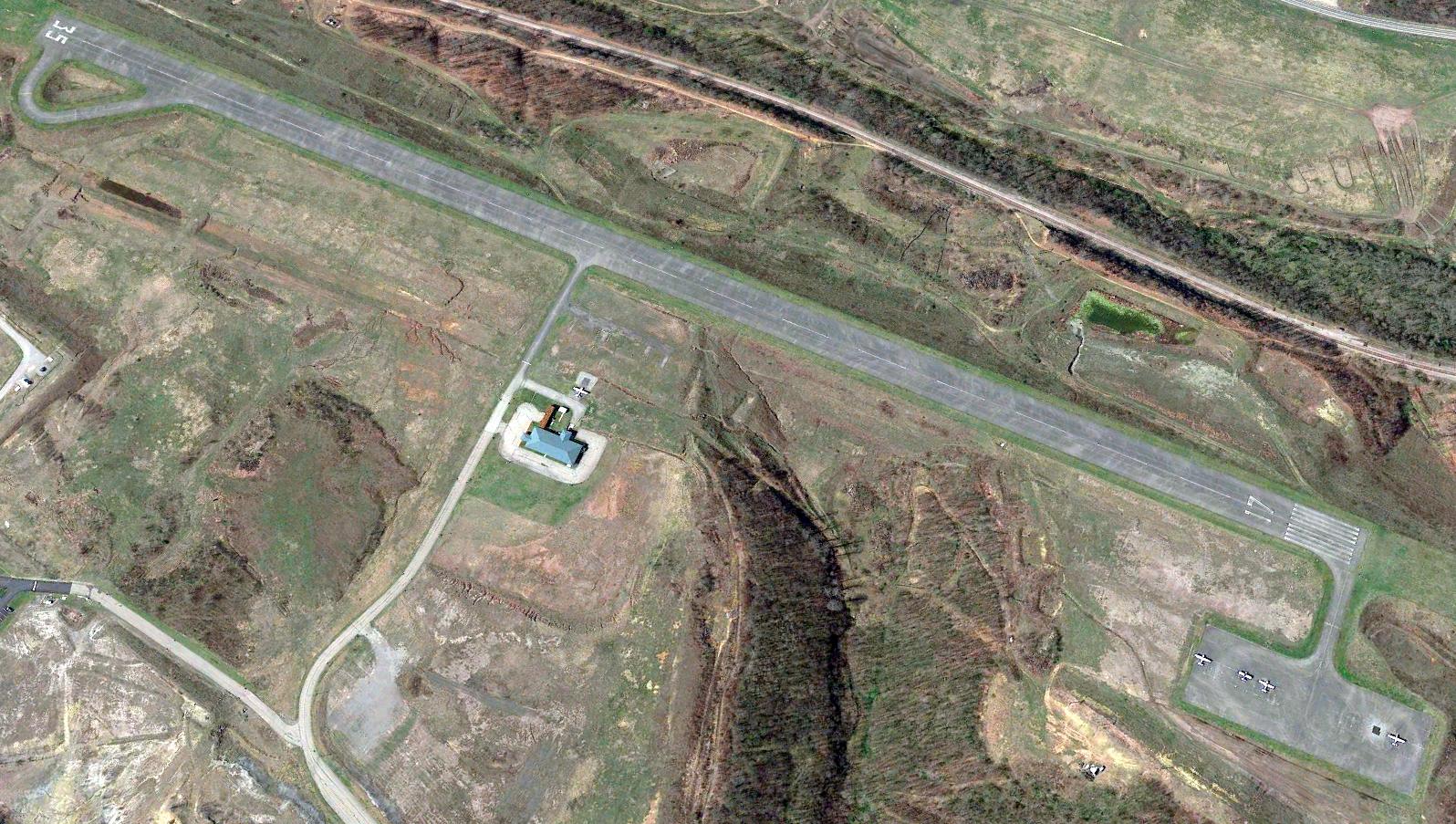
The last aerial photo which has been located showing aircraft at Rock Airport was a 2016 aerial view looking southwest, which showed 5 light single-engine aircraft on its east & northeast ramps.
According to Wikipedia, as of March 2019, no aircraft are based in the facility.
According to Jonathan Ostlund, “In 2013 the airport went into bankruptcy & was bought by Alaskan Property Management, with the sale finalized in 2014.”
According to Jonathan Ostlund, “By 2019, activities had ceased at the airport with no notice of closure.
There has been minimal activity at the airport since.”
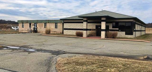
The last photo which has been located showing aircraft at Rock Airport was a May 2019 photo by Jonathan Ostlund, showing a Cessna parked behind its terminal building.
A 2019 aerial view showed Rock Airport intact, but devoid of aircraft.
According to Wikipedia, In 2022, the airport was used by Carnegie Mellon University to test drones.
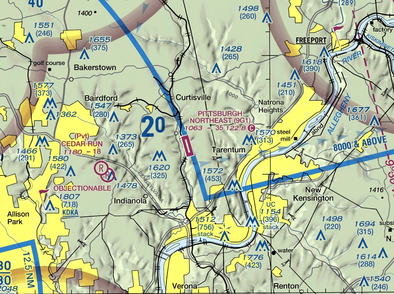
The last aeronautical chart depiction which has been located of Pittsburgh Northeast Airport was on the 2024 Pittsburgh Terminal Chart.
It depicted Pittsburgh Northeast as having a single northwest/southeast 3,500' paved runway.
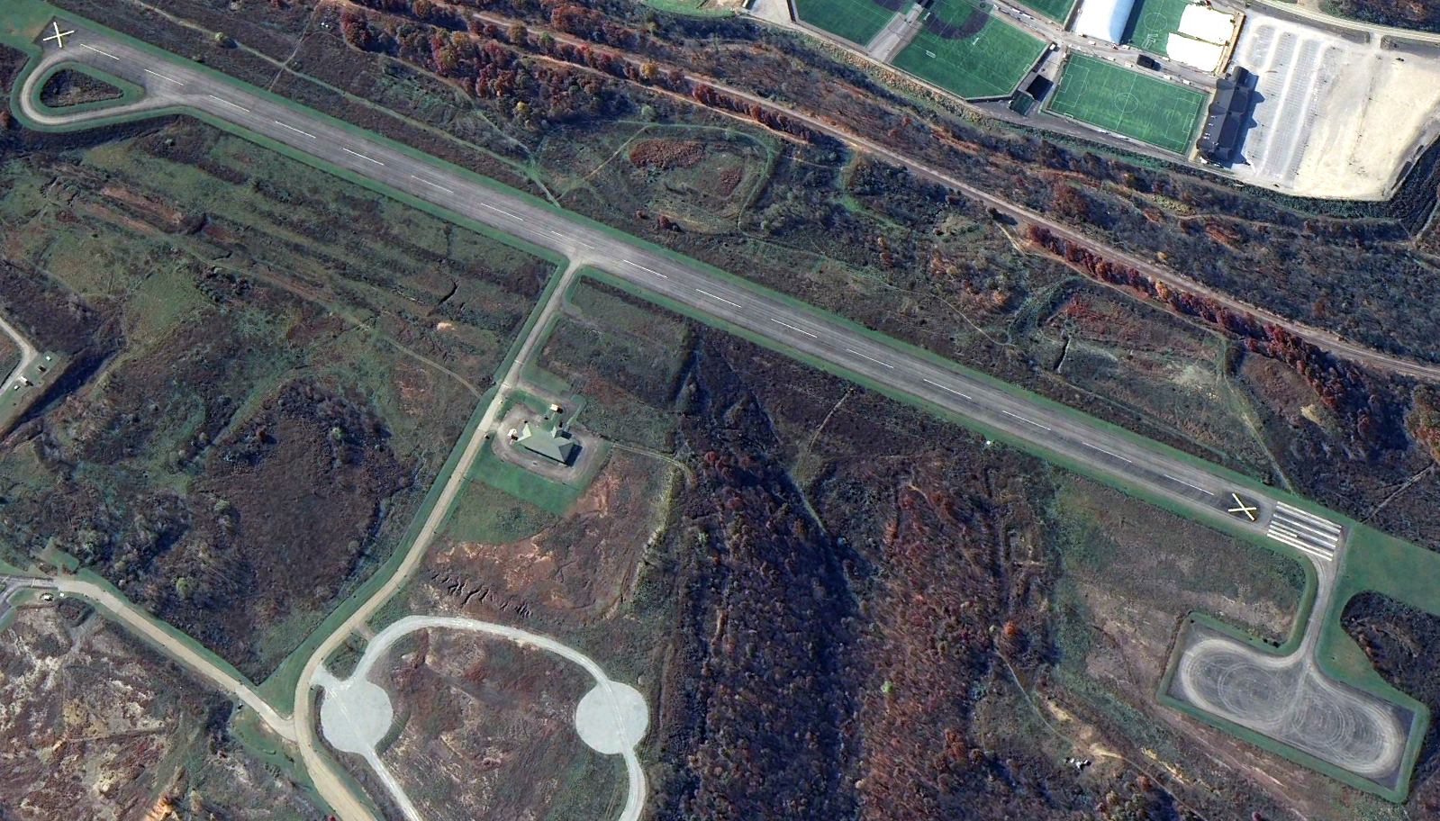
Pittsburgh Northeast Airport was evidently closed at some point between 2024-2025,
as a 2024 aerial view looking southwest showed closed-runway “X” symbols on both runway ends.
Pittsburgh Northeast Airport was depicted as an abandoned airfield on the 2025 Pittsburgh Terminal Chart.
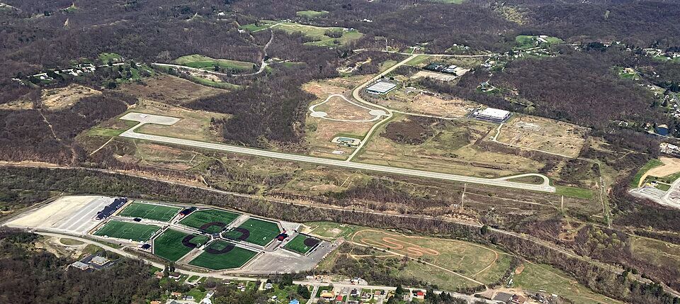
An April 2025 aerial view looking east by Jonathan Ostlund showed Rock Airport to remain intact.
Thanks to Jonathan Ostlund for pointing out this airfield.
____________________________________________________
Conway Airport / Conway-Pittsburgh Airport, Conway, PA
40.67, -80.23 (Northwest of Pittsburgh, PA)
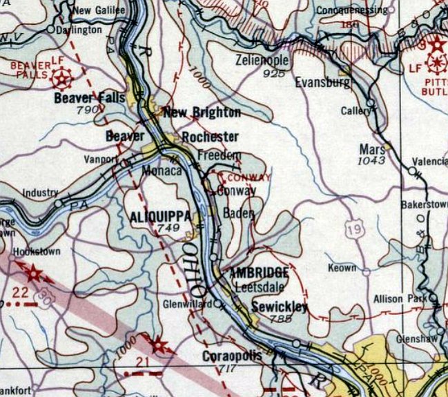
Conway Airport, as depicted on the December 1932 Cleveland Sectional Chart.
According to the Conway Borough website, this small general aviation airport dated back to 1920.
The earliest aeronautical chart depiction which has been located of Conway Airport was on the December 1932 Cleveland Sectional Chart.
It depicted Conway as a commercial/municipal airport.
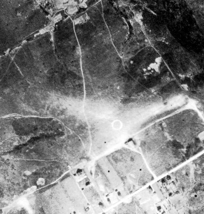
The earliest photo which has been located of Conway Airport was an 11/9/38 aerial view (fromPenn Pilot).
It depicted the field as having 2 grass runways of approximately 1,300' in length.
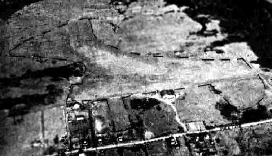
A 10/21/43 aerial view looking north from the 1945 AAF Airfield Directory (courtesy of Scott Murdock)
depicted Conway Airport as having 3 unpaved runways, with several buildings along the south side.
Ken Hendrickson recalled, “I worked as a lineboy at Conway Airport from 1944 (14 years old) through 1948 then as an instructor on the GI bill till 1950.
I had a GREAT career that all started at Conway as a lineboy shortly after my 14th birthday at $5/week & 2 hours of flying.”
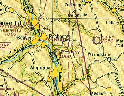
The June 1945 Cleveland Sectional Chart (courtesy of Dick Merrill) depicted Conway as a commercial/municipal airport.
The 1945 AAF Airfield Directory (courtesy of Scott Murdock) described Conway Airport
as a 70 acre rectangular property having 3 sod runways, the longest being the 1,500' northeast/southwest & east/west strips.
The field was said to have a single 70' x 50' iron hangar,
was described as being owned by Beaver County, and operated by private interests.
A 1947 aerial view showed 7 light aircraft parked around one small building on the south side of the field.
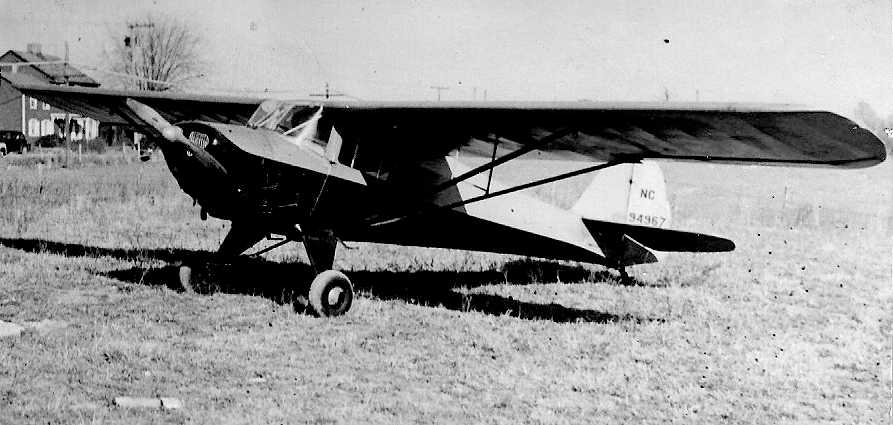
A 1947 photo by Ken Hendrickson of Taylorcraft “94967, one of 4 Taylorcrafts we brought from Alliance OH when we moved the factory.
Ben Mauro sold it to 8 of us for $1600 ($200 apiece) for helping to move the factory.
The selling price back then was $2,200.”
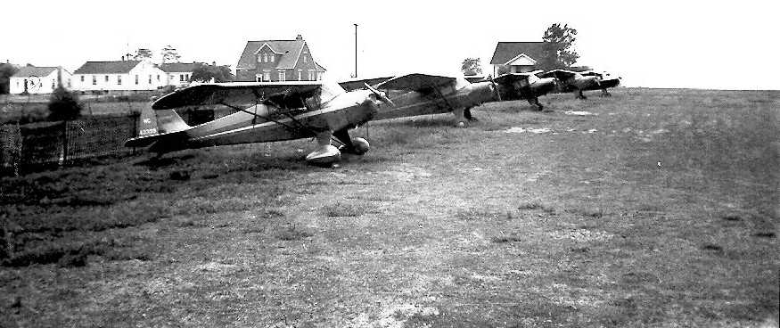
A 1947 photo by Ken Hendrickson looking west at 5 Taylorcrafts at Conway Airport.
In 1949 C.G. Taylor bought the assets of Taylorcraft from the former company, and started a new company Taylorcraft, Inc. at Conway.
The company re-started production of the BC-12D Traveler & the BC-12-85D Sportsman.
The company produced few aircraft & the type certificates were sold to Univair & production was halted.
Ken Hendrickson recalled, “I helped move the Taylorcraft factory from Alliance Ohio (which Ben Mauro the owner of Conway had purchased, I believe it was late 1946 or 1947).
Jack Gilberti was the aircraft engineer at Taylorcraft at Conway.”
The Taylor Aircraft Company headquarters moved to Connellsville, PA in 1950.
A 1952 aerial view showed 3 light aircraft parked on the south side of the field.
The 1953 Cleveland Sectional Chart depicted “Conway-Pittsburgh” as having a 1,900' unpaved runway.
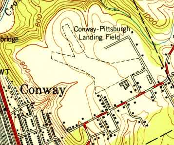
The 1953 USGS topo map depicted “Conway-Pittsburgh Landing Field” as having 2 unpaved runways with the hangar on the southeast side.
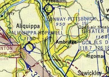
The January 1955 Cleveland Sectional Chart (courtesy of Chris Kennedy) depicted “Conway-Pittsburgh” as having a 1,900' unpaved runway.
According to Richard Finley, the Taylor Aircraft Company ceased operations in Conway in 1956.
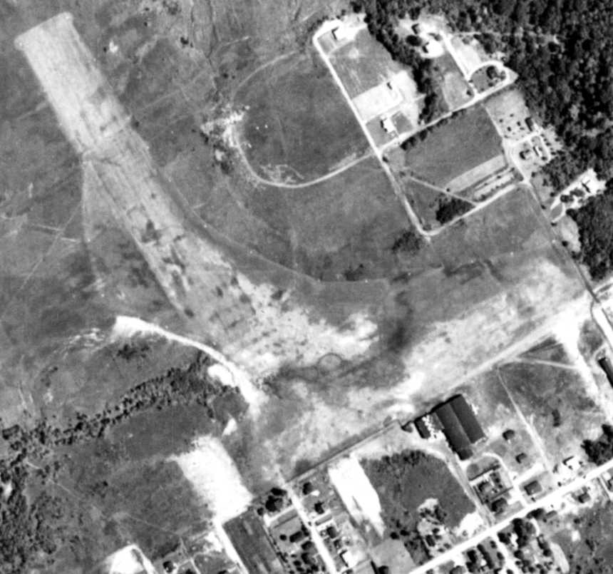
A 6/3/58 aerial view (fromPenn Pilot) depicted Conway Airport as having several grass runways.
A single light plane was visible next to the buildings on the south side.
This presumably was the Taylorcraft plant, but the buildings hardly looked big enough for aircraft production.
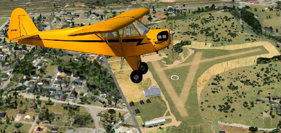
A Flight Simulator scenery re-creation by Richard Finley of a Cub overflying Conway Airport.
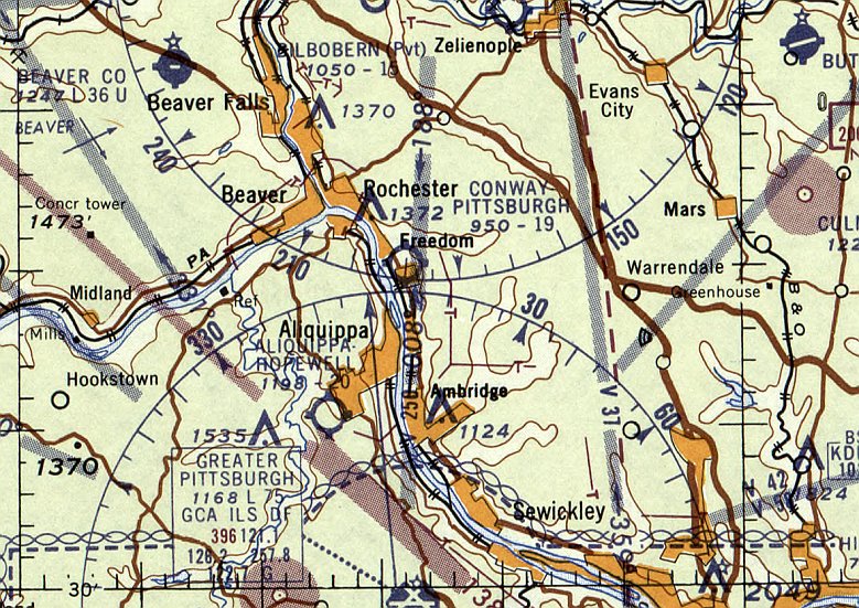
The last aeronautical chart depiction which has been located of Conway Airport was on the was on the July 1960 Cleveland Sectional Chart.
It depicted “Conway-Pittsburgh” Airport as having a 1,900' unpaved runway.
According to Richard Finley, the manager of Conway Airport was Joe Rabassi.
The airport closed (for specific reasons unknown) in 1961.
According to Richard Finley, “After the airport closed, the hangar served as a grocery store then flea market.”
Conway Airport was no longer depicted on the May 1965 Cleveland Sectional Chart.
A 1969 aerial view showed that houses had been built over the western portion of the runway,
but the hangar remained intact.
According to Richard Finley, “The hangar was destroyed by a fire in the mid-to-late 1980s.”
The 4/7/93 USGS aerial photo showed the foundation of the hangar as the only remaining trace of Conway Airport.
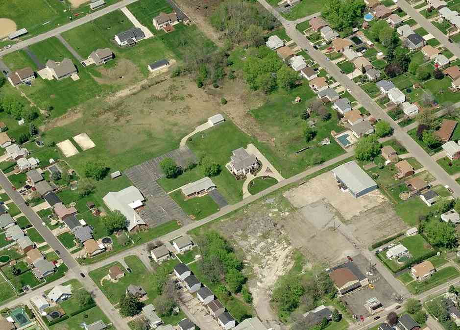
A circa 2005-2010 aerial view looking north at the site of Conway Airport.
What appeared to be pavement at the bottom of the photo is actually the remains of the hangar foundation.
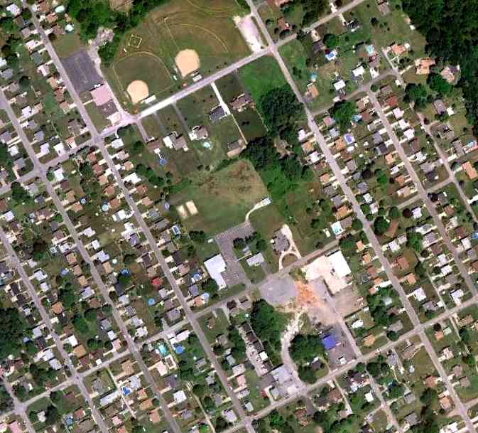
A 7/3/10 aerial view showed the foundation of the hangar as the only remaining trace of Conway Airport.
According to the Conway Borough website, as of 2011 the location of the hangar was “the present site of Albert’s Heating behind the Shank’s convenience store.
Some of Conway’s streets were laid out following the taxi and runways for the airport, including Highland Avenue & Foote Streets.”
The site of Conway Airport is located west of the intersection of Highland Avenue & Sampson Street.
____________________________________________________
Pittsburgh-McKeesport Airport / Bettis Field / Curtiss-Bettis Airport / Pittsburgh-Bettis Airport, Pittsburgh, PA
40.36, -79.9 (Southeast of Downtown Pittsburgh, PA)
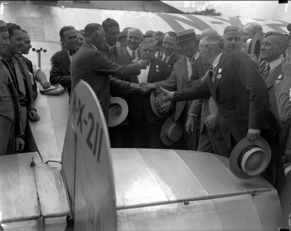
An 8/3/27 photo of Charles Lindbergh's arrival at Bettis Field.
This airfield was originally known as the Pittsburgh-McKeesport Airport.
An early Mifflin Township resident, Barr Peat, lived quite near to the end of a field where early barnstorming aviators would land.
One day a plane landed in the field, and the grass was so high that the pilot did not see a tree stump & crashed his plane on landing.
This planted the seed into Barr Peat’s mind that there ought to be an airport around here somewhere.
When Barr Peat looked down from this grassy meadow at the top of the hill he noticed a big beautiful pasture directly below.
This 144 acre property was owned by Harry Neel. Barr Peat contacted Neel, who was a personal friend, and made a deal in 1924 to allow planes to land on his property.
This began a 25 year span for the flying field.
Airplane rides were sold for a small charge, and aerobatics were performed for the thrilled spectators who began to appear.
Soon other planes arrived & the site started to look like an airport.
Crowds assembled every weekend to the field to take rides & watch all the excitement the early aviators had to show.
While the thrills of flying went on, Barr Peat continued working on his dream of an airport.
Barr Peat scraped some money up to have the field graded.
Sam Brendel put a "couple of thousand dollars" into supplying the field with aviation fuel & oil.
The first airshow at this fledgling airfield was promoted in 1925 with the help of Congressman Clyde Kelly.
The U.S. Army Air Corps brought transports, bombers, and pursuit planes.
There was parachute jumping & an air race.
Elmer Best stated, "It was on a triangular course, about 15 miles around.
One pylon, about 30 feet high, was at the intersection of Homestead-Duquesne Road & Brierly Lane."
Sightseeing rides & air show thrills were becoming a regular thing for many residents.
They could take flying lessons from Bob Trader’s flying school.
Aviation was catching on in the area at the Pittsburgh-McKeesport Airport, as it was known at that time.
Aviators began using the field more & the Airways Tavern was built across from the airport.
In 1925, with some other small buildings on the field & grading completed,
the Pittsburgh-McKeesport Airport Company announced the opening of the field to the public.
Attending this grand affair was Lt. Cyrus Bettis & the Army Air Corps.
The airport was managed by Barr Peat who welcomed spectators to inspect the facilities.
The opening also included the announcement that the field would become the base of operations
for air mail service under government contract.
Barr Peat & Cliff Ball were very anxious & willing to progress. They knew that the business was there.
It was up to Cliff Ball to buy the equipment & he was continuously looking for new equipment.
When Ball bought airplanes in those days they were "bare-bone" & a lot of other things had to be purchased.
They were interested in getting the airmail service started.
In 1925 the Kelly Air Mail Act provided that private carriers could bid on airmail contracts.
The nation’s first contract was awarded to Clifford Ball Airlines.
The contract was for the 120 miles between Pittsburgh & Cleveland.
Due to some equipment & financial problems the airmail service did not start until 1927.
Cliff Ball Airlines did announce a passenger service between Pittsburgh & Cleveland.
Fares were $15 one-way & $25 round trip for a one hour twenty-minute flight each way.
Aviation during the Twenties was highlighted by barnstorming & air racing.
Lt. Cyrus Bettis, of the U.S. Army Air Corps,
won the Mitchell Trophy for air racing in 1924 & the Pulitzer Trophy in 1925 with a world record flying speed of 249 mph.
He also represented the Army in air shows around the country.
In 1926 Lt. Bettis was en route from Philadelphia to Selfridge Field in Michigan,
leading a formation of 3 Army airplanes.
Near Bellefonte, PA they encountered a heavy fog & Bettis hit the treetops & crashed into Jack’s mountain.
After he regained consciousness, Bettis crawled to a road several miles away.
He was rescued & taken to Walter Reed Hospital.
He seemed to be recovering from his wounds, but 14 days later he died when complications set in.
To honor this great aviator the airfield was renamed as Bettis Field in 1926.
Roscoe Turner came to Bettis Field with what was at the time the largest biplane in the world, a Sikorsky twin-engine bomber.
In 1927, the first airmail was received & sent out on Cliff Ball Airlines. Ball had purchased 9 biplanes.
At least one of these, the Miss Pittsburgh, survives today in Rhinebeck, NY.
The blue & silver craft, carrying the mail in a front baggage area, flew daily from Pittsburgh to Cleveland.
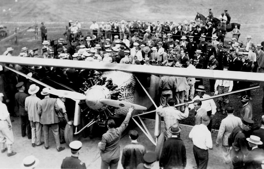
Charles Lindbergh lands the "Spirit of St. Louis" at Bettis Field in 1927.
Also in 1927, Charles Lindbergh landed at Bettis, in the course of his goodwill tour of the world in the Spirit of St. Louis.
The airfield was packed that day.
"The streets were lined with people all the way through Lincoln Place" recalled Walt Godleski.
At the airport the Spirit was put in a hangar sideways, because it would not fit in the largest hangar otherwise.
Ken Scholter, remembered that the stipulation for Lindbergh’s appearance was the Spirit had to be hangared.
"We greased some boards & slid the wheels along them into the hangar," recalled Scholter.
Col. Lindbergh left at noon the next day as a crowd of 30,000 cheered him.
T.J. Stefanic recalled, “My father lived nearby & was at the TWO Lindberg landings.”
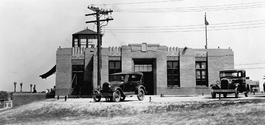
A circa 1920s photo of the Bettis Field terminal building.
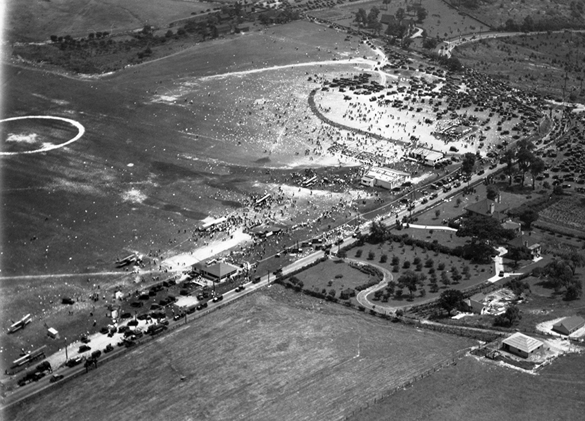
A circa 1928 aerial view of aircraft & spectators at Bettis Field (from the book Bettis: Where Pittsburgh Aviation Took Off, by Brian Butko & Sue Morris, HHC Detre L&A, Ball Collection).
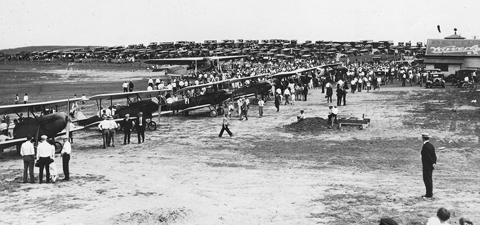
A circa 1928 aerial view of aircraft & spectators at Bettis Field (from the book Bettis: Where Pittsburgh Aviation Took Off, by Brian Butko & Sue Morris, HHC Detre L&A, Scholter Collection).
In 1928 the National Elimination Balloon Races were held at Bettis Field.
According to reports more than 150,000 people jammed the field, the largest crowd ever to witness an air event in Pittsburgh.
The 14 entrants got the weather go-ahead & lifted off at 6 p.m.
Within a half hour a thunderstorm brewed & the balloons were caught.
A number of them were struck by lightning & went down.
Army balloon # 3 was hit near Youngwood, PA, and Lt. Paul Evert died in the crash.
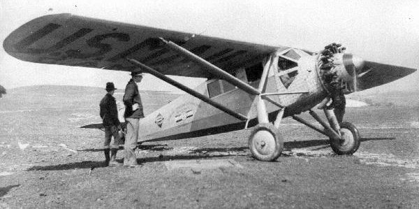
A 1928 photo by Cliff Ball of a Ryan at Bettis Field, with Ken Sheltar at left.
The Ryan was one of several used by Cliff Ball Airlines on the Washington-Pittsburgh-Cleveland route.
In 1928, Barr Peat & Bo Phelan, another investor in the airport company, sold their original shares they purchased for $2,000 for $50,000 each.
In 1929 Ball sold his remaining interests to Curtiss-Wright. Cliff Ball Airlines eventually evolved into Pennsylvania Airlines.
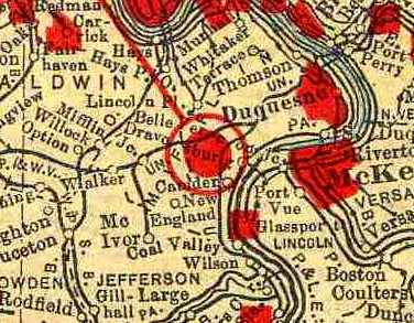
Bettis Field, as depicted on the 1929 Rand McNally "Standard Indexed Map With Air Trails" (courtesy of Chris Kennedy).
It described Bettis Field as being operated by the Pittsburgh-McKeesport Airport Corporation.
The field was described as being 1,650' x 2,500' in size, with a beacon light & landing lights.
From 1929 on Bettis Field began losing some of its glamor.
The depression hit, taking away jobs & money & the novelty of airplanes flying was beginning to wear off.
Bill Wood recalled, “I grew up in McKeesport & my uncle, August (Gus) Becker, owned & operated the Pittsburgh Institute of Aeronautics from 1929.
Gus Becker purchased Bettis Field from Curtis-Wright in 1930 & used the facility from the early 1930s.
Bettis Field was used by the Pittsburgh Institute of Aeronautics
for training aircraft & engine mechanics for work in the civil & military aviation field.
Most civilian graduates were later employed by the airlines operating in the USA.”
Dale Becker recalled, “My father, August Becker, ran the airport from approximately 1930-1946.
I also worked at Bettis Field Airport at the time for my father.”

A 1930 aerial view of Bettis Field.
In 1932 the Allegheny County Airport opened only one mile to the west, and it was at that time the largest airport on record.
Commercial planes & transports moved there, leaving Bettis with small private planes.
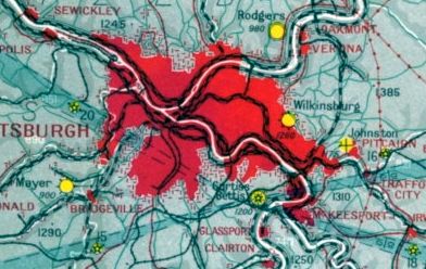
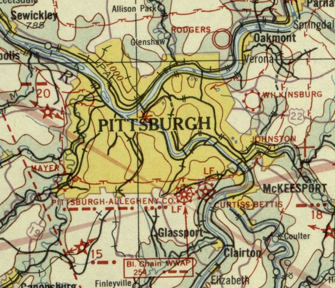
The earliest aeronautical chart depiction which has been located of Bettis Field was on the December 1932 Cleveland Sectional Chart.
It depicted Curtiss-Bettis as a commercial/municipal field.
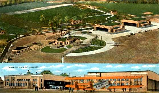
Two undated colorized photos from a postcard sent in 1933 of “Curtiss-Bettis Airport”.
The 1934 Department of Commerce Airport Directory (according to Chris Kennedy)
described "Pittsburgh-Bettis Airport" as being an irregular sod field measuring 2,500' x 2,200',
with 3 hard-surfaced runways in the center of the field, with the longest being an 1,800' north/south strip.
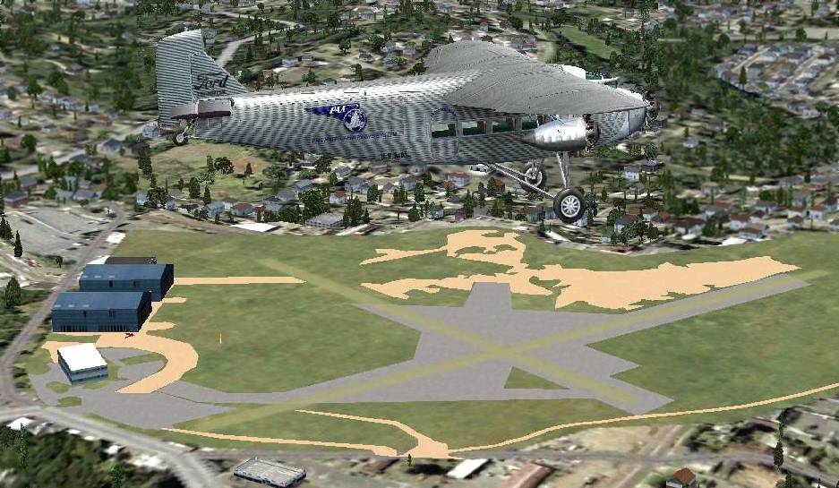
A Flight Simulator scenery re-creation by Richard Finley of a Ford Tri-Motor overflying Bettis Field.
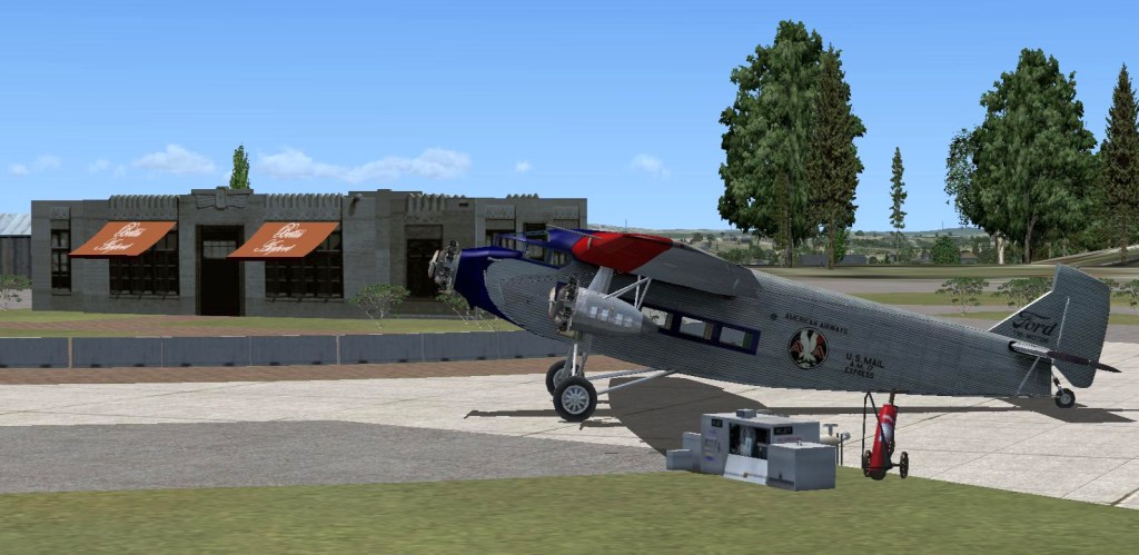
A Flight Simulator scenery re-creation by Richard Finley of a Ford Tri-Motor at Bettis Field.
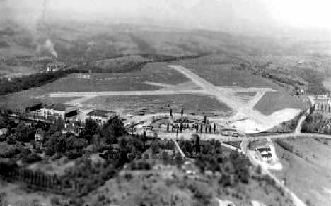
An undated aerial view looking northeast at Bettis Field (courtesy of Dan Almashy),
showing 3 runways, as well as several hangars along the west side of the field.
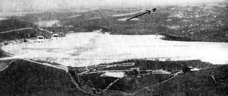
An aerial view looking northwest at Bettis Field,
from The Airport Directory Company's 1937 Airports Directory (courtesy of Tom Beamer).
The directory described Bettis Field as having 3 sod runways, with the longest being the 1,800' north/south strip.
The aerial photo in the directory depicted 2 fairly substantial hangars on the west side of the field,
which were described as having "Curtiss-Bettis" painted on the roof.
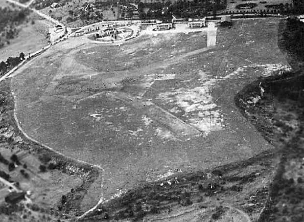
A circa 1930s aerial view looking southwest at Bettis Field (courtesy of Bill Wood).
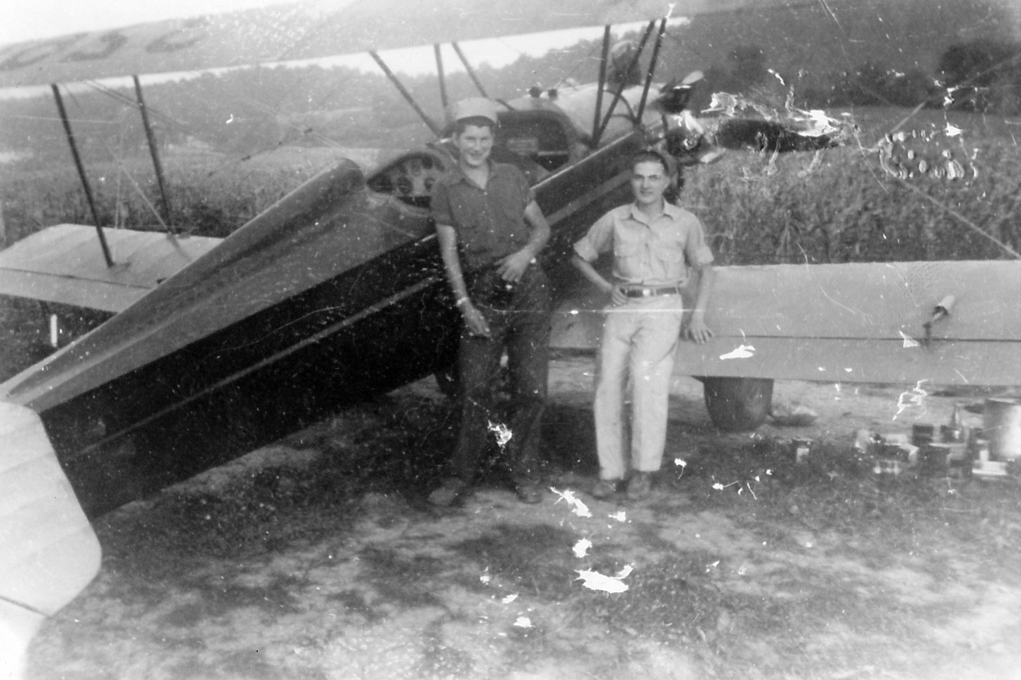
A circa late 1930s photo by Z. Hayducko of a Fleet biplane at Bettis Field (courtesy of T.J. Stafanic).
T.J. Stefanic recalled, “My mother was pursuant to obtaining her private pilots license there in the late 1930s.”
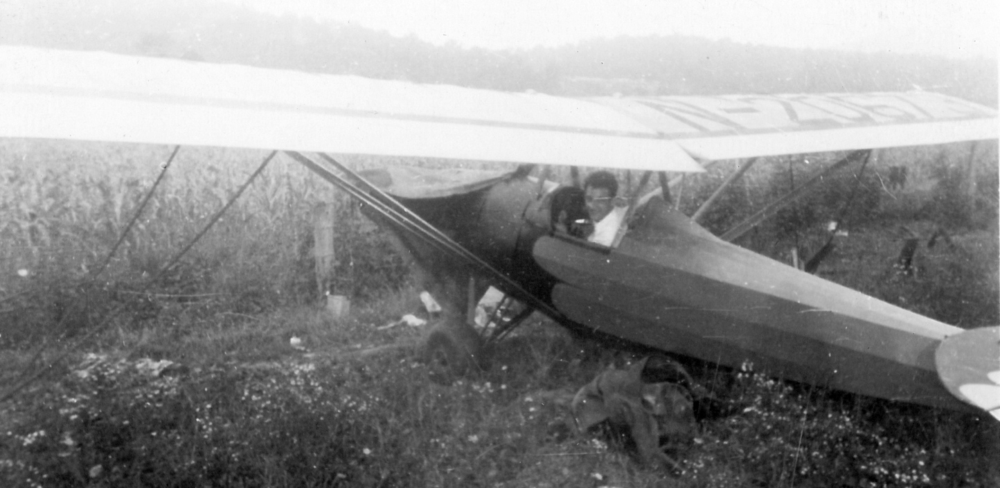
A circa late 1930s photo by Z. Hayducko of a Keiling-Heath parasol monoplane at Bettis Field (courtesy of T.J. Stafanic).
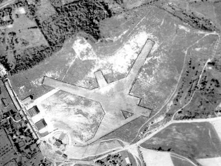
A 10/2/38 aerial view (courtesy of David Brooks) depicted Bettis Field as having 3 paved runways,
with the hangars & administration building along the southwest side of the field.
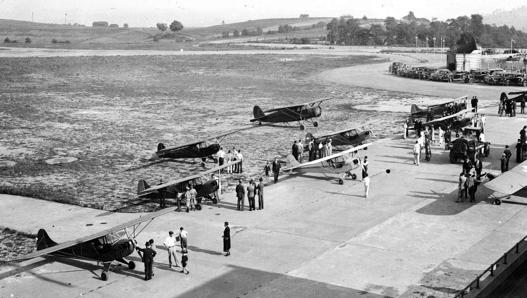
A circa 1930s view of several Piper Cubs on the Bettis ramp (courtesy of Dale Becker), “taken from the top of Hangar #1.”
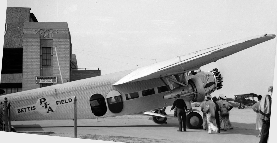
A circa 1930s view (courtesy of Dale Becker) of a Ford Tri-Motor marked “Bettis Field” in front of the 1st hangar.
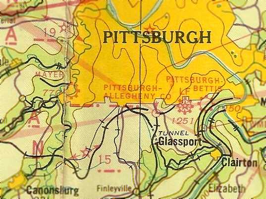
The March 1940 Cleveland Sectional Chart (courtesy of Richard Finley)
depicted Pittsbugh-Bettis as a commercial/municipal field.
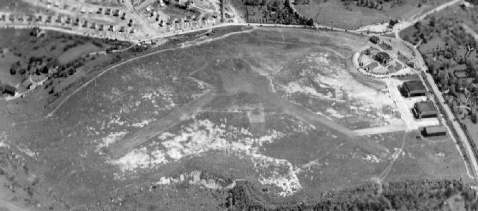
A circa 1940 aerial view by William Mason looking east at Bettis Field (courtesy of Edward Wolf).
Bill Wood recalled, “My father, Bill Wood, was the Pittsburgh Institute of Aeronautics superintendent during most of World War 2.”
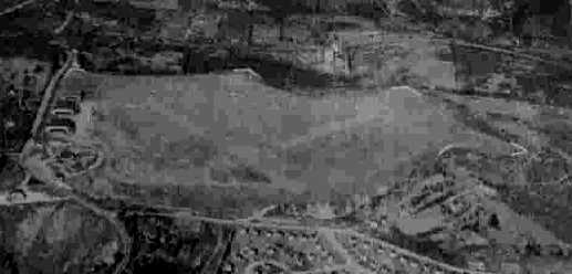
The last photo which has been located of Bettis Field while still operational was a 10/29/43 aerial view looking north
from the 1945 AAF Airfield Directory (courtesy of Scott Murdock).
It depicted Bettis Field as an open grass landing area with 2 hangars along the west side.
Bill Wood recalled, “World War 2 was spent training US Army Air Force mechanics under contract to the War Department.
Classrooms were located in the Pittsburgh Institute of Aeronautics building in downtown Pittsburgh.
Bettis Field had 2 hangars & a number of shops that were used to give practical experience working on aircraft & powerplants.”
The runway at Bettis was evidently paved by 1944,
as the 1944 US Army/Navy Directory of Airfields (courtesy of Ken Mercer)
described Bettis Field as having a 2,500' hard-surface runway.
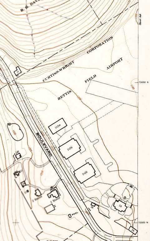
A 1945 Pittsburgh Department of City Planning topo map labeled the property as “Curtiss-Wright Corporation Bettis Field Airport.”
It depicted the terminal building & 3 hangars, along with a portion of one runway.
The 1945 AAF Airfield Directory (courtesy of Scott Murdock) described Bettis Field
as a 150 acre irregularly-shaped property within which were 2 macadam runways: 2,000' northeast/southwest & 1,535' WNW/ESE.
The field was said to have 2 hangars, the largest being a 125' x 104' brick structure,
and it was described as being owned & operated by private interests.
Bill Wood recalled, “My uncle, August (Gus) Becker, used the facility through 1945,
when Gus sold Bettis & Pittsburgh Institute of Aeronautics to the current owners.”
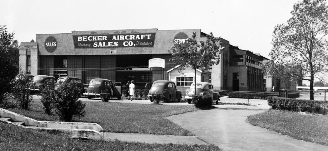
A circa 1940s photo (courtesy of Dale Becker) of the Becker Aircraft Sale Company hangar at Bettis Field.
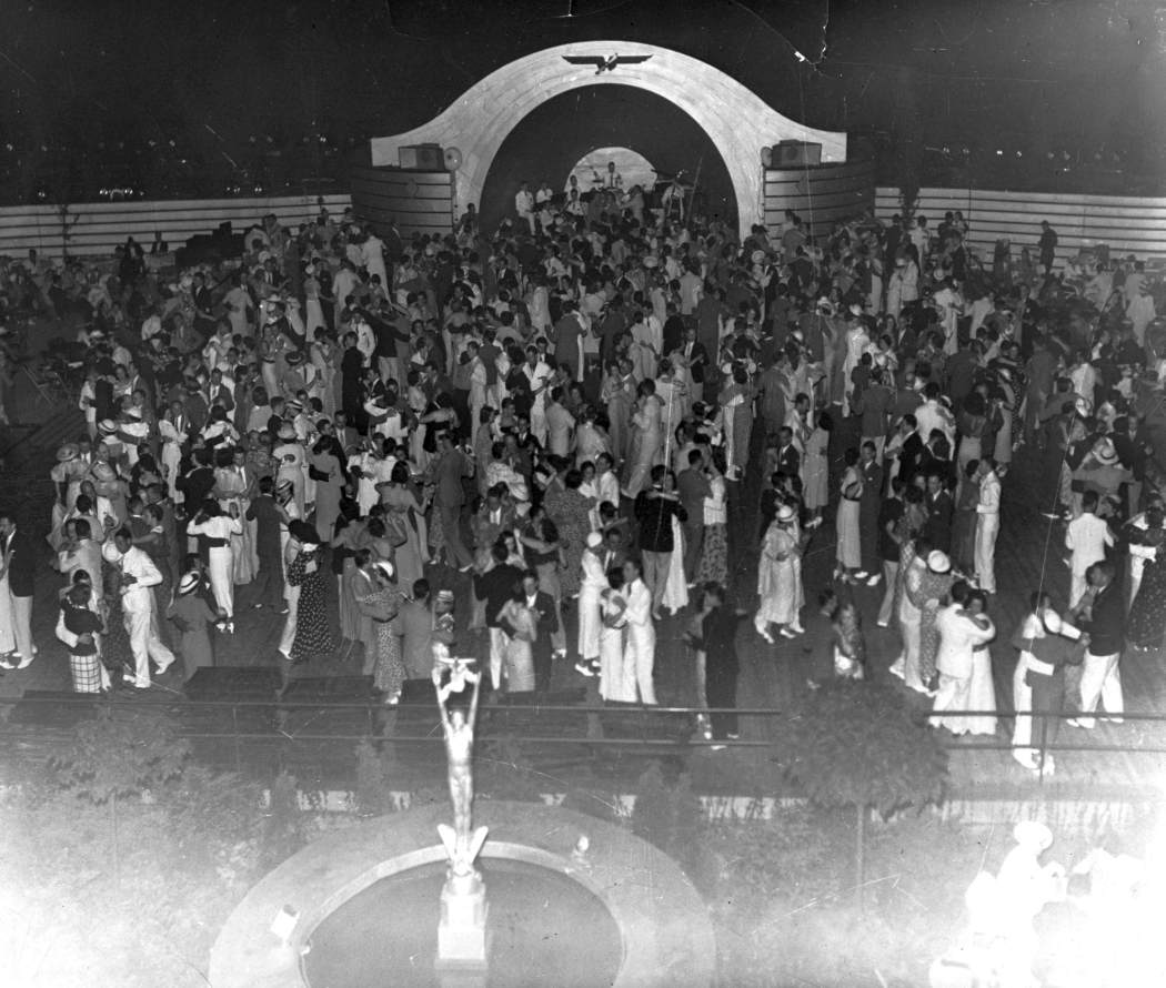
An undated view (courtesy of Dale Becker) “of the dance floor when the Administrative building was turned into a night club called the 'Sky Club'.
Curtiss Wright took a dim view of this as it was not according to lease agreement. It only lasted a short time; 6-10 months.
This was an outside dance floor with band shell in the rear lawn of the Administration building.”
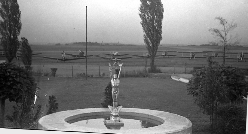
A 1945-46 photo (courtesy of Dale Becker) of the “same location after the Sky Club closed – the statue & bushes were still there.
The picture was taken from the back steps of the Administration building.
The aircraft in the background were government surplus being sold by sealed bid.”
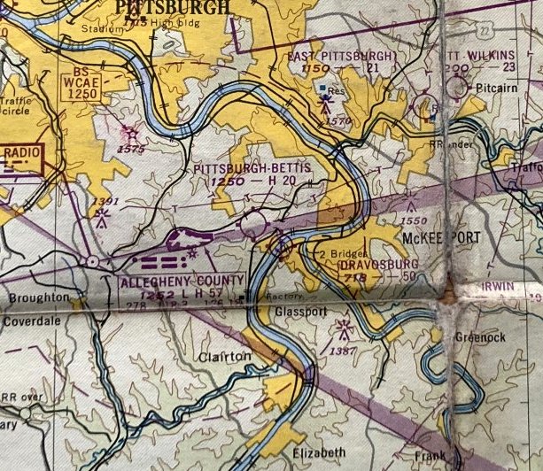
The January 1948 Pittsburgh Local Aeronautical Chart (courtesy of Tom Imrich) depicted “Pittsburgh-Bettis” Airport as having a 2,000' paved runway.
The last photo which has been located of an aircraft at Bettis Field was a 1948 aerial photo,
which depicted a few light aircraft around the terminal at the southwest corner.
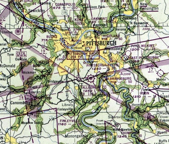
The last aeronautical chart depiction which has been located of Bettis Field was on the January 1949 Cleveland Sectional Chart.
It depicted “Pittsburgh-Bettis” Airport as having a 2,000' paved runway.
Curtiss-Wright reportedly sold Bettis Field to Westinghouse in January of 1949, and Westinghouse closed the field.
The Bettis Field property was redeveloped as the site of the Bettis Laboratory,
which developed naval nuclear propulsion technology for submarines & aircraft carriers.
A 1949 aerial view showed closed-runway “X” markings having been painted on either end of both runways,
and no aircraft were visible on the field, which otherwise remained intact.
Bettis Field was no longer depicted on the December 1949 Cleveland Sectional Chart.
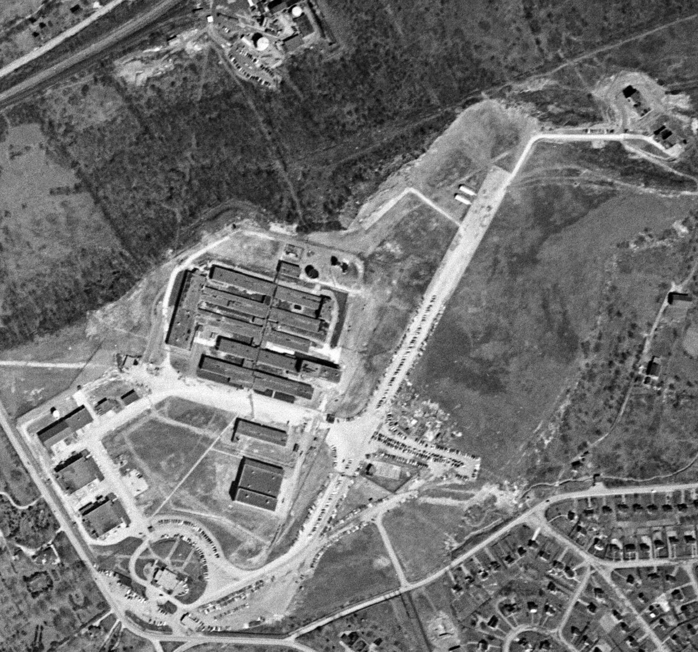
A 4/9/52 USGS aerial view showed that buildings had covered portions of Bettis Field at some point between 1949-52,
but the majority of the northeast/southwest runway remained intact.
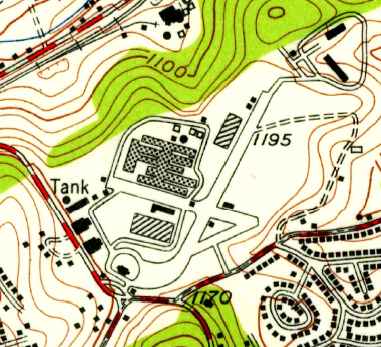
The 1953 USGS topo map showed that 2 of Bettis Field's runways remained intact, but industrial buildings had been constructed on either side of them.
According to Erik Wagner, “The last airplane landed at Bettis long after it closed.
In the late 1950s someone landed a single-engine aircraft there.
Ostensibly, the pilot said it was mistaken identity due to the then-prevalent smoke obscuration.
He thought it was Allegheny County, the large former air-carrier field 1 mile to the West.
Of course, it was, by then, the classified atomic power plant operated by Westinghouse
as Admiral Hymen Rickover's pet project for the US Navy nuclear propulsion project.”
An indication of the sensitivity of the Bettis Laboratory may be seen by examining the 5/29/67 USGS aerial photo,
on which the site of Bettis Field was completely censored,
which has not been seen on any other USGS aerial photos of that era.
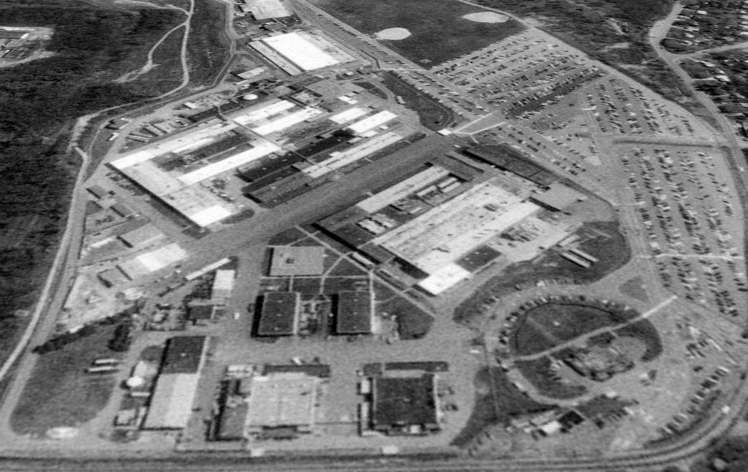
A 1993 aerial view looking northeast showed that 2 former Bettis Field hangars still remained along the west side of the site,
along with the former Administration Building at bottom-right,
and the remains of 2 paved runways (northeast/southwest & northwest/southeast) were still plainly apparent.
The Bettis Laboratory was still open as of 2003, and is operated for the Department of Energy by Bechtel Bettis Inc.
Two large former hangars & the former administration building still remained standing (as of 2003), as part of the Bettis Laboratory.
If you drive by on Pittsburgh-McKeesport Boulevard & look through the fence at the former hangars,
the wings & propellers in cement-relief images are still visible.
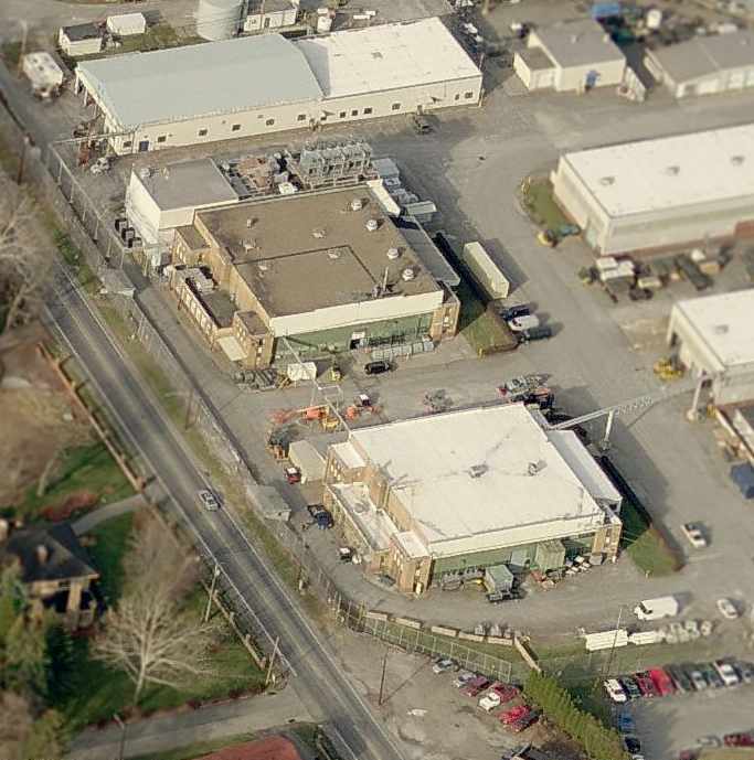
A circa 2006 aerial view looking north at the 2 former hangars which remain along the west side of the former Bettis Field.
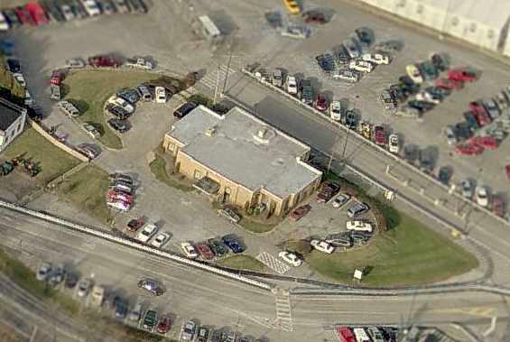
A circa 2006 aerial view looking north at the former Bettis Field Administration Building.
A 2008 aerial view still showed the former Bettis Field Administration Building remaining standing.
A 2010 aerial view showed the former Bettis Field Administration Building had been removed at some point between 2008-2010,
replaced by a parking lot.

A 2017 aerial view looking northeast showed that 2 former Bettis Field hangars still remained along the west side of the site.
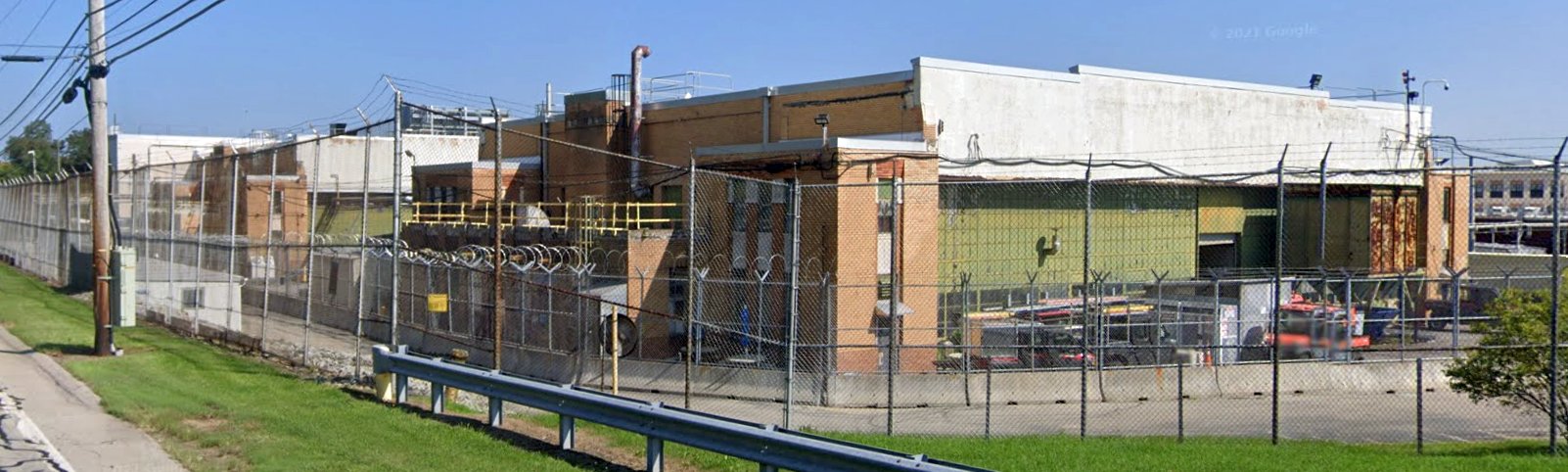
An August 2021 photo looking north at the 2 former hangars which remain along the west side of the former Bettis Field.
The site of Bettis Field is located north of the intersection of Pittsburgh McKeesport Boulevard & Bettis Road,
only one mile east of the Allegheny County Airport.
See also:
http://facweb.stvincent.edu/academics/english/faculty/wissolik/AIRPORTEARLYDAYSPART1/index.htm
http://www.15122.com/MTHS/NEWS/April2002newsletter.pdf
____________________________________________________
Campbell Airport (1st location), Cuddy Hill, PA
40.359, -80.189 (Southwest of Pittsburgh, PA)
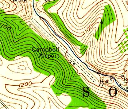
The original location of Campbell Airport, as depicted on the 1960 USGS topo map.
This general aviation airport located down in a valley was named after its owner, Charles Campbell.
Nothing was yet depicted at the eventual location of this airport on the 1953 USGS topo map nor on a 9/29/57 aerial photo.
Jay Gelm recalled of Campbell Airport, “I knew Mr. Campbell Sr when I soloed out of the valley airport in 1958.
It was in operation before it was charted on any maps. Things moved very slowly back then as far as updates on any maps or charts.
When I was there it was already operating as an airstrip before 1958. On or about that time Campbell Sr. was flying a Twin Navion there.
I recall one day he attempted to take off with the nose wheel 'hangar bar' still attached to the nose gear.
He left the airport operation basically to his son Chuck Jr. while he took care of the Campbell Coal Company.
My instructor there was a Pittsburgh pilot named Clark Woodard.
Chuck Campbell Jr. was running the operation down in the valley & sold Champion Aircraft. I purchased a ¼-share in N7512E, a Champion 7AC.
While I was in the process of a Private & Commercial ticket I would at times fly with Chuck to Wisconsin to the Champion factory & ferry a new one back for him.
At that time they were also selling the small Mooney M20 & M21, a very cramped 4-place.
The strip in the valley had what I would call the first VASI 3-light landing system.
They built a box with 3 lights angled up, red to low, green OK, and white high. It worked quite well at night & was there for quite a few years.”
A 1959 aerial view showed 2 light aircraft on the field,
which consisted of an unpaved northwest/southeast strip, with a single building on the southeast side.
Campbell Airport was not yet depicted on the 1960 Cleveland Sectional Chart (courtesy of Mike Keefe).
The 1960 USGS topo map depicted Campbell Airport as having a single unpaved northwest/southeast runway,
with 2 small buildings along the southwest side.
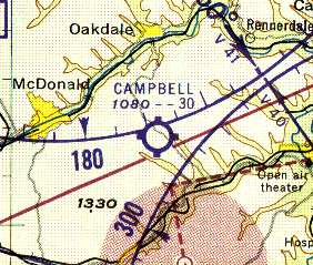
The earliest depiction which has been located of Campbell Airport was on the 1961 Pittsburgh Local Aeronautical Chart (courtesy of Mike Keefe).
It described Campbell Airport as having a single 3,000' "slag" runway.
According to Erik Wagner, "I remember the old runway operating with Chuck Campbell Sr. as owner.”
According to Ray Gelm, “The airplane that Mr. Campbell Sr. flew there was a Navion twin conversion. I rode around the pattern one time with him in it."
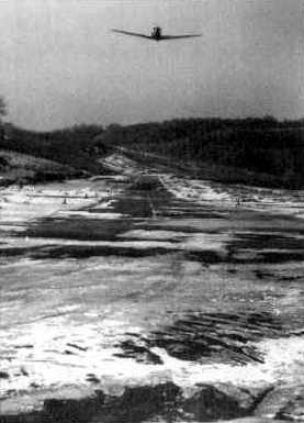
A 1962 view along the runway of Campbell Airport, with a plane overhead (courtesy of Nina Cotter).
Campbell Airport was described in the 1962 AOPA Airport Directory as having a single 2,500' asphalt Runway 13/31, and the operator was listed as Charles Campbell.
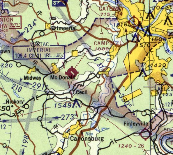
The last depiction which has been located of the original Campbell Airport was on the May 1965 Cleveland Sectional Chart.
It depicted Campbell Airport as having a 2,500' paved runway.
At some point between 1965-67, the original Campbell Airport in the valley
was replaced by a new Campbell Airport along the top of a ridge slightly to the south.
The original runway became the site of Pittsburgh International Dragway, a drag strip.
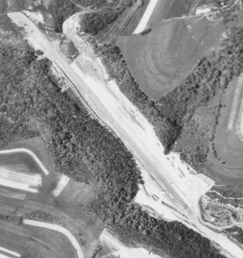
A 5/26/67 aerial photo appeared to show the former runway of the original Campbell Airport after it had been reused as a drag strip.
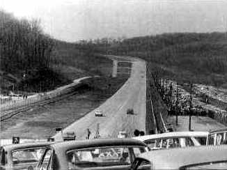
A 1969 view along the former runway of Campbell Airport, reused at the time as the Pittsburgh International Dragway (courtesy of Nina Cotter).
The Pittsburgh International Dragway closed in 1976, and the former Campbell Airport property has presumably been abandoned since that time.
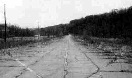
A recent (1980s?) view along the former runway of Campbell Airport, after the closure of the Pittsburgh International Dragway (courtesy of Nina Cotter).
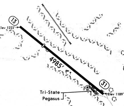
The airfield layout of Pittsburgh Metro Airport, from a 1994 airport directory, showing both the original runway (at the top), and the later runway (center).

A 2025 aerial view looking northeast showed the original Campbell Airport runway to remain intact though deteriorated.
The site of the original Campbell Airport is located west of the intersection of Route 50 & Route 978.
____________________________________________________
Campbell Airport (2nd location) / Pittsburgh Metro Airport (8G4), Cuddy Hill, PA
40.35, -80.18 (Southwest of Pittsburgh, PA)
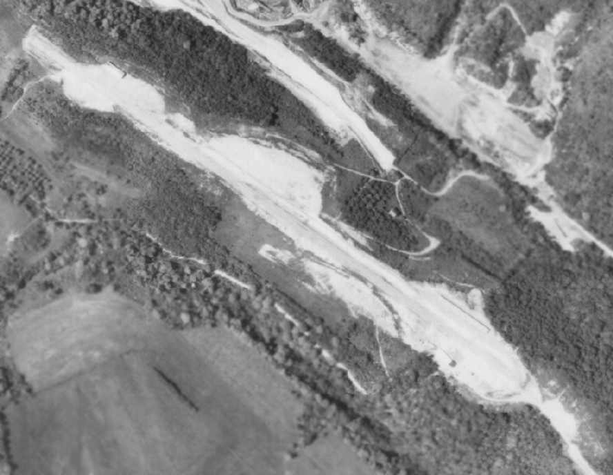
A 5/26/67 aerial photo appeared to show the site of the 2nd location of Campbell Airport
shortly after it began operation at its new location (or while it was still under construction).
At some point between 1962-67, the original Campbell Airport in the valley
was replaced by a new airport with a single paved runway along the top of a ridge slightly to the south.
The earliest depiction that has been located of the 2nd location of Campbell Airport was a 5/26/67 aerial photo.
It appeared to show the site shortly after it began operation at its new location (or while it was still under construction),
with a single paved northwest/southeast runway,
and a few small buildings along either side of the southeast end of the runway.
A 1969 aerial view showed a well-used airfield, with over a dozen aircraft, including at least 2 twin-engine aircraft.
Kimberlee Campbell reported, “I am the daughter of the owner, Charles Campbell Jr.
Actually, my grandfather was not much involved ever in the running of the airfield, or of the dragstrip;
it was mostly my father, who sold Mooneys, then MU-2s, and later Swearingen Merlins, and finally Piper Cheyennes.
I myself flew out of the upper airport, and got my license there as a young woman.”
Jay Gelm recalled, “Not too long after being built, a very high wind or microburst sent almost all the parked aircraft over the hill.”
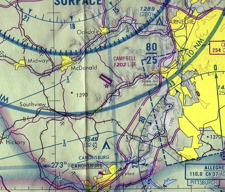
The earliest aeronautical chart depiction which has been located of Campbell Airport
was on the May 1975 Pittsburgh Terminal Aeronautical Chart (courtesy of Mitchell Hymowitz).
It depicted Campbell as having a 3,600' paved runway.
The 1976 Pittsburgh Local Aeronautical Chart (courtesy of Mike Keefe)
depicted Campbell Airport as having a 3,600' paved runway.
Kimberlee Campbell reported, “The airport did continue to function after the death of my father in 1978;
however, the climate for business was not kind in the early 1980s - you may remember the incredible rates on loans back then -
and my mother was unable to continue to run the airport.
By the time of the 1982 AOPA Airport Directory (courtesy of Ed Drury), Campbell's runway had been lengthened to 5,000',
and the operators were listed as Campbell Air Midwest, Pittsburgh Corporate Aircraft Service Center,
and Piper Corpac Service Center.
According to Erik Wagner, "The new runway was extended to 5,000' because Campbell sold Mooney MU-2s
and later opened Cheyenne Air Center (Corpac) to sell Cheyennes.
I remember the old runway operating with Chuck Campbell Sr. as owner."
According to Chris Kennedy, Campbell Airport was described in the 1986 Flight Guide
as having a single 5,000' "rough" paved Runway 13/31.
By that time, the former runway was no longer depicted on the diagram.
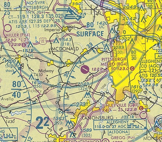
At some point between 1986-93, Campbell Airport was renamed Pittsburgh Metro Airport,
as that is how it was labeled on the October 1993 Detroit Sectional Chart (courtesy of Ron Plante).
It was depicted as havng a 5,000' paved northwest/southeast runway.
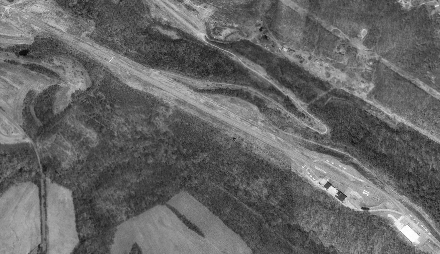
A 1993 USGS aerial view looking north depicted Pittsburgh Metro Airport as having a total of at least 13 aircraft parked on the field,
and 2 hangars sat at the southeast end of the runway.
The lettering "PGH METRO" was painted on the runway in front of the hangars.
The airfield layout of Pittsburgh Metro Airport, from a 1994 airport directory,
showing both the original runway (at the top), and the later runway (center).
The operators were listed as Pegasus Aviation, Pittsburgh Metro Airport, and Tri-State Helicopter.
According to a pilot who once flew out of the field, Pittsburgh Metro Airport was purchased at an unknown date by developers,
who stopped maintaining the airport (fuel service, etc.)
and began to run large trucks back & forth along the runway (to access the large hangar for storage purposes).
At that point the state provided the option of stopping the trucks or closing the airport.
Pittsburgh Metro Airport was closed in 1994-95.
According to Erik Wagner, "Pittsburgh Metro (Campbell Airport) went into foreclosure
and was purchased by a developer who had little interest in airplanes.
After he could not get permission to do what he wanted,
he was unable to make a deal to reopen the airport."
In the late 1990s a small group of local pilots made a pitch to purchase the airport & reopen it,
as they had secured funding for replacing the runway & other improvements from state & local government.
However, the pilots were unable to come to financial terms with the owner-developer,
so the deal was terminated.
Given Pittsburgh Metro's relatively close proximity to PIT,
and the continuous appearance of radio towers around the population base,
it doesn't appear as if the airport will ever become a viable GA facility again.
Kimberlee Campbell [daughter of the former airport owner] reported,
“To me, and after all of my father's work to build up that airport, it was very sad to see that it is no longer used.”
An account of the recent status of the former airport was provided by local pilot Jonathan Goodish,
who visited the site in the late 1990s.
The old airport entrance is located just off of Route 50.
The entrance is in a valley, and there is a long, winding asphalt road which leads to the airport at the top of the hill.
An old illuminated sign remained with some of the lettering for "Pittsburgh Metro" still visible,
but not enough to identify the entrance.
However, an old aircraft-tamper warning sign did remain at the entrance, making the field easy to identify.
About halfway up the entrance road there appeared to be grading from where a hangar once stood on the hillside.
At the top, there were 2 smaller hangars & one larger hangar.
One of the smaller hangars still had a "King" avionics sign on the side.
The runway ran along a ridgeline at the very top of the hill,
and still existed complete with a rusted windsock skeleton & faded "PGH METRO" lettering.
The runway existed but was cracked & somewhat overgrown.
When Goodish overflew the airport site in 2000, there appeared to be trailers lined up along the entire length of the runway.
Myles Lilley reported that in an aerial photo from 2002,
"it seems that the trucks that were parked on the runway at Pittsburgh Metro Airport were gone."
Myles Lilley reported in 2006, “I visited the old Pittsburgh Campbell / Metro Airport last week
and it still has storage trailers on the runway.
The runway markings are visible & even my 5 year-old son recognized the old buildings as an airport.
It would still be a nice airport (if I hit the lottery).
Right now a screen printing business, a landscaping company and the storage company occupy the land.”

A circa 2007 aerial view looking west at the west side of the site of Pittsburg Metro Airport,
including the former hangars, and the Runway “31” markings & “PGH Metro” lettering which remain evident on the former runway.
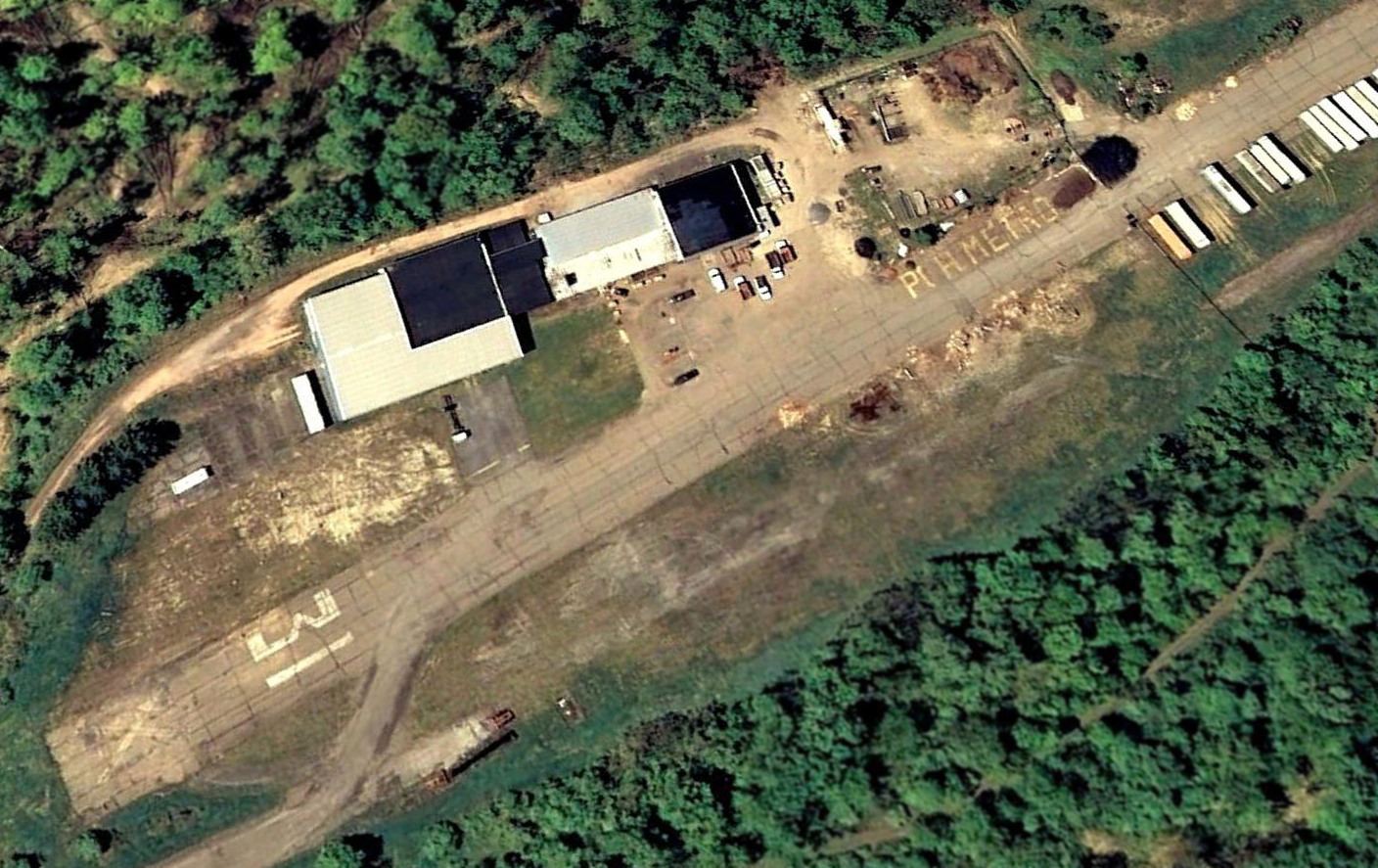
A 2007 aerial view looking southwest showed the Runway “31” markings & “PGH Metro” lettering which remain evident at the site of Pittsburgh Metro Airport.
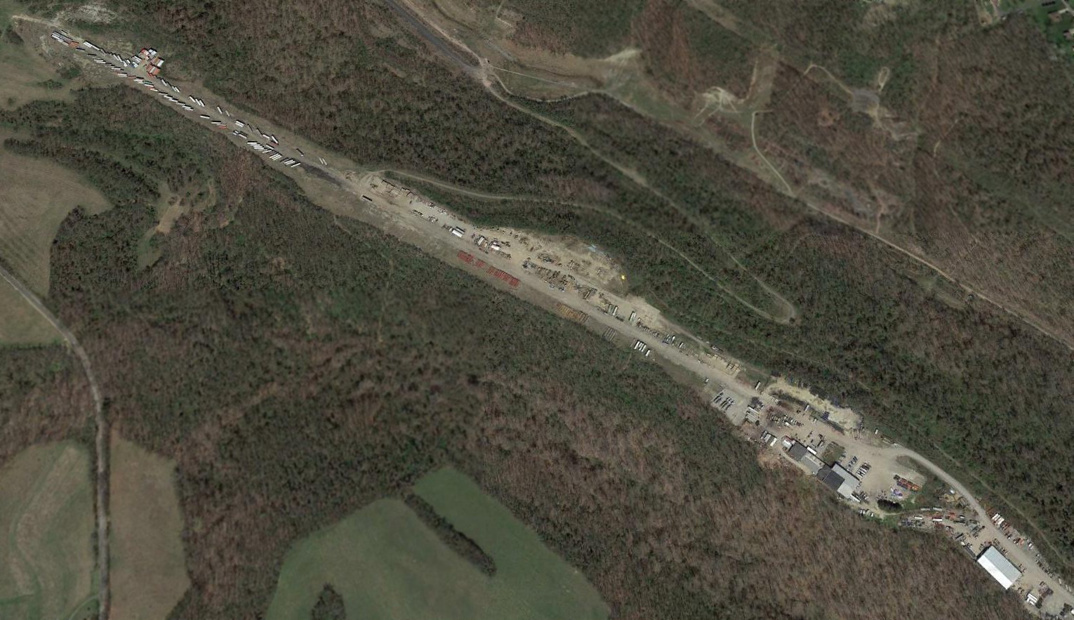
A 2016 aerial view looking north showed the former Pittsburgh Metro Airport runway & hangars remained intact, with trucks lining the former runway.
Pittsburgh Metro Airport is located west of the intersection of Route 50 & Route 978.
____________________________________________________
Or if you prefer to contact me directly concerning a contribution (for a mailing address to send a check),
please contact me at: paulandterryfreeman@gmail.com
If you enjoy this web site, please support it with a financial contribution.
____________________________________________________
This site covers airfields in all 50 states.