Abandoned & Little-Known Airfields:
Georgia: Northern Atlanta area
© 2002, © 2025 by Paul Freeman. Revised 11/22/25.
This site covers airfields in all 50 states: Click here for the site's main menu.
____________________________________________________
Please consider a financial contribution to support the continued growth & operation of this site.
Cline Ranch Strip (revised 3/18/22) - Cobb Airport / Cobb Air Park / South Cobb Airport (added 3/17/22) - Cole Field (revised 11/22/25) - Mathis Airport / Mathis Field (revised 11/28/23)
Parkaire Field (revised 8/16/24) - Stone Mountain Britt Memorial Airport (revised 11/28/23)
____________________________________________________
Cobb Airport / Cobb Air Park / South Cobb Airport, Atlanta, GA
33.869, -84.591 (Northwest of Downtown Atlanta, GA)
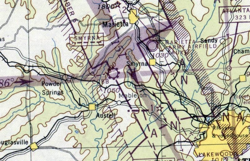
Cobb Airport, as depicted on the April 1946 Birmingham Sectional Chart (courtesy of David Henderson).
Cobb Airport was not yet depicted on the October 1945 Birmingham Sectional Chart.
David Henderson reported, “Located on 40 acres along Austell Road between Marietta & Mableton, Cobb Airport was opened on 3/15/46
by pilots Roy Manning, Herbert Hunter and T.G. Shaw, who was also the airport business manager.”
The earliest depiction which has been located of Cobb Airport was on the April 1946 Birmingham Sectional Chart (courtesy of David Henderson).
It depicted Cobb as a commercial/municipal airport.
David Henderson reported, “A June 1946 Marietta Journal article reported that 17 aircraft were based at Cobb Airfield at the time:
6 Taylorcrafts owned by the airport along with 11 private aircraft including Piper Cubs, a Stinson, a Stearman, Fairchilds and additional Taylorcrafts.
Flight training & student flights evidently kept the airport busy in the early years.
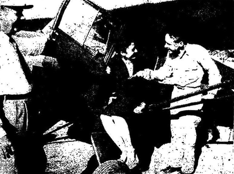
The earliest photo which has been located of Cobb Airport was an undated photo from a June 1946 article (courtesy of David Henderson)
of instructor Bill Brannen congratulating 21-year-old Nora Sentell after her first solo flight.
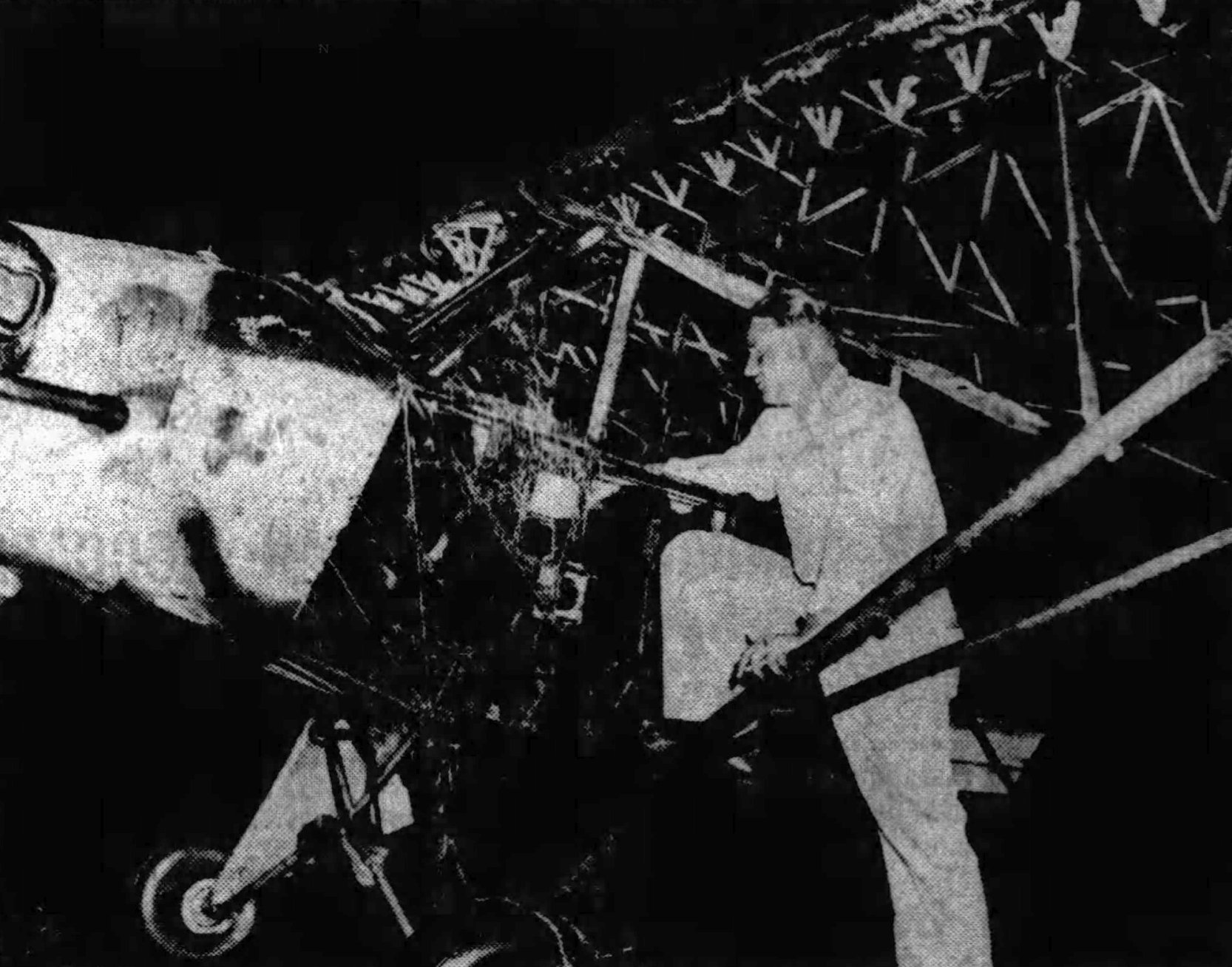
An undated photo (courtesy of David Henderson) of W.A. Reed surveying his Piper Cub after a 5/27/48 lightning strike at Cobb Airport, which burned the fabric off, leaving only the frame.
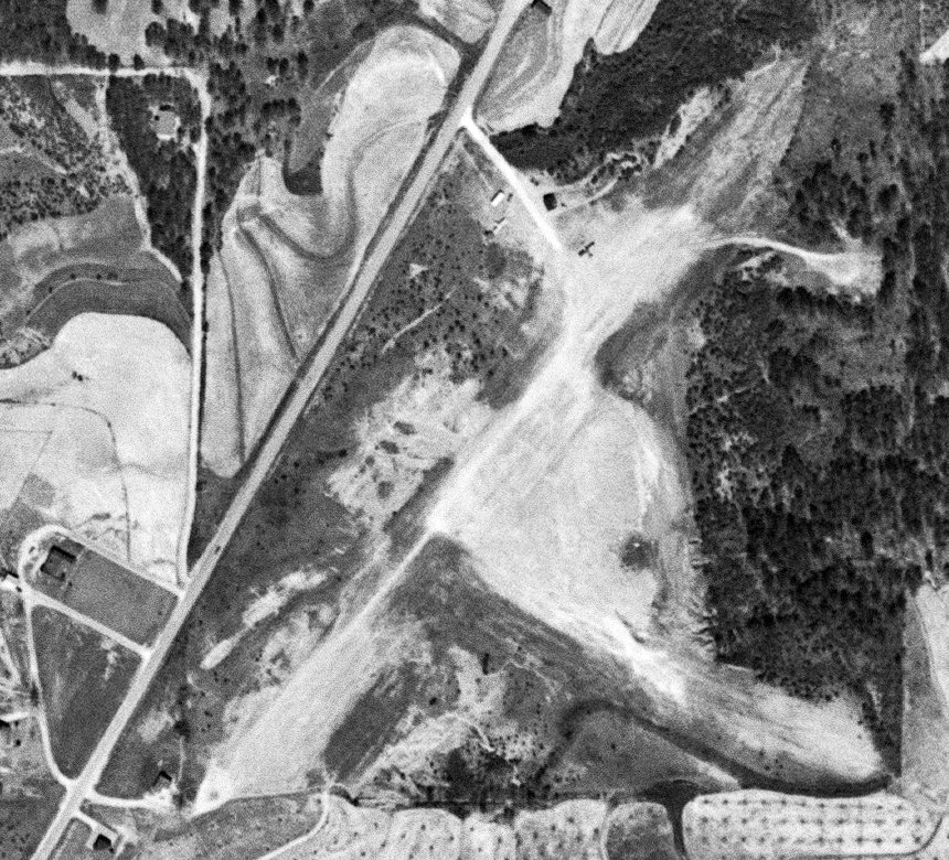
The earliest aerial photo which has been located of Cobb Airport was a 1952 aerial view (courtesy of David Henderson).
It depicted Cobb as having 2 unpaved runways, with 2 light single-engine planes parked near a few small buildings at the north end.
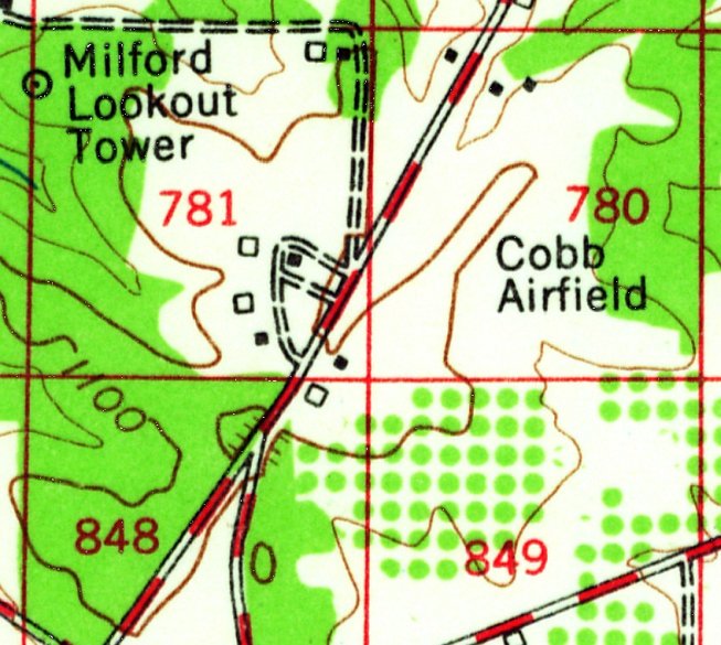
The earliest topo map depiction which has been located of Cobb Airport was the 1954 USGS topo map (courtesy of David Henderson).
It depicted Cobb Airfield as an open area, with no runways depicted, and a few small buildings at the north end.
David Henderson reported, “As development began to surround the field during the 1950s, airport neighbors complained of constant noise,
revving engines, 'enormous' dust clouds, dangerously low aircraft, declining property values & unauthorized tree cutting along property lines.
In 1958, the Cobb Superior Court temporarily restricted airport activity following a lawsuit from the owners of the neighboring orchard
who claimed the airfield was damaging its property and commercial operations.
Cobb County opened the nearby McCollum general aviation airport in 1960,
with a 4,000' paved runway & modern facilities, and it seemed that Cobb Airfield's days were numbered.”
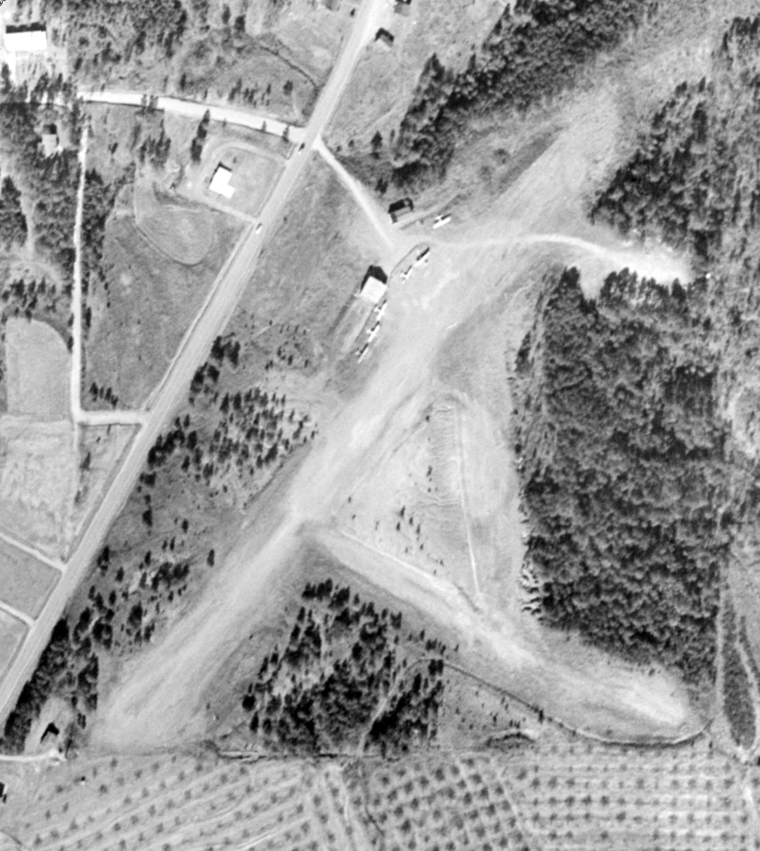
The last photo which has been located of Cobb Airport was a 1960 aerial view (courtesy of David Henderson).
The runway & building configuration was the same as depicted in the 1952 photo, but the number of aircraft visible on the field had increased to 6.
David Henderson reported, “During the early 1960s, flight instruction continued at the field,
cadets from the Civil Air Patrol regularly trained during evenings & occasional skydiving exhibitions were held on weekends.”
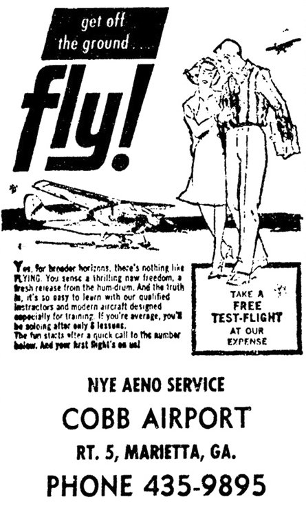
A 1961 advertisement for Cobb Airport's Nye Aero Service (courtesy of David Henderson).
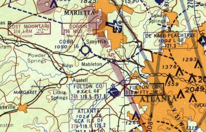
The last aeronautical chart depiction which has been located of Cobb Airport was on the February 1961 Birmingham Sectional Chart (courtesy of David Henderson).
It depicted Cobb as having a mere 1,600' unpaved runway.
David Henderson reported, “Following years of decline, the airport was closed sometime in the mid-1960s.”
Cobb Airport was evidently closed at some point between 1961-65, as it was no longer depicted on the April 1965 Birmingham Sectional Chart.
David Henderson reported, the Cobb Airport property “was sold in 1967 to make way for the Marbro Twin Drive-In Theatre which held its grand opening 12/20/68.”
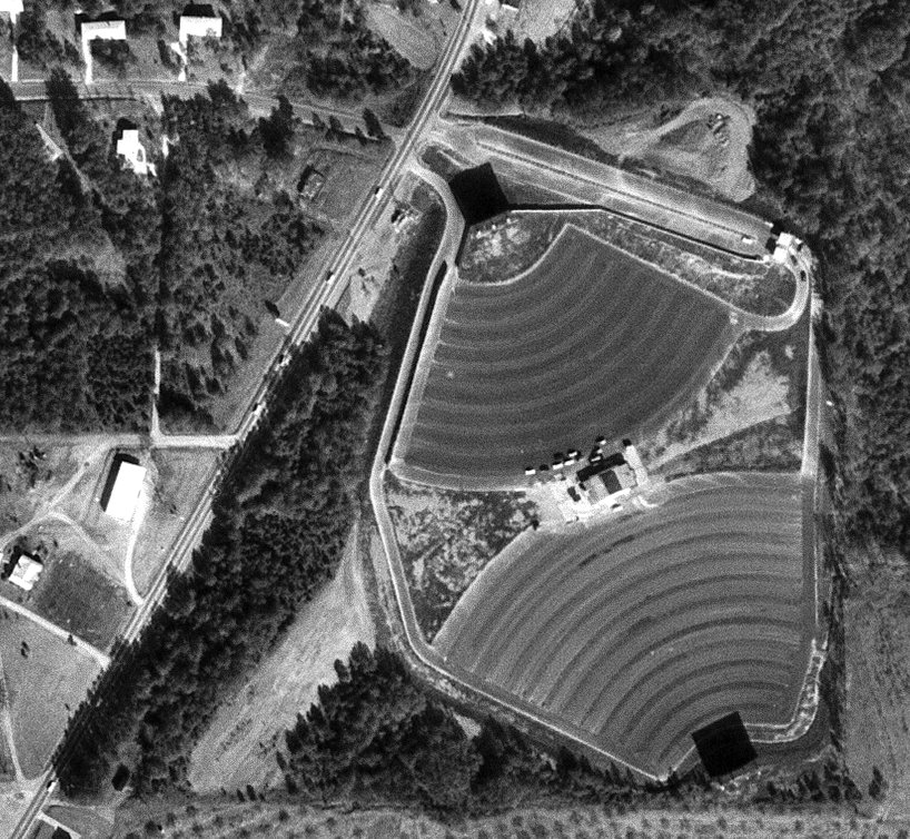
A 1968 aerial view (courtesy of David Henderson) showed the Marbro Twin Drive-In Theatre occupying the majority of the Cobb Airport site, but a small portion of the southwest runway end remained clear.
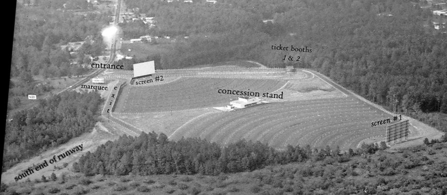
A 1968 aerial view looking north (courtesy of David Henderson) showed the Marbro Twin Drive-In Theatre occupying the majority of the Cobb Airport site, but a small portion of the southwest runway end remained clear.
David Henderson reported, “The Drive-In lasted until 1987 when it was replaced by a shopping center & apartments.”
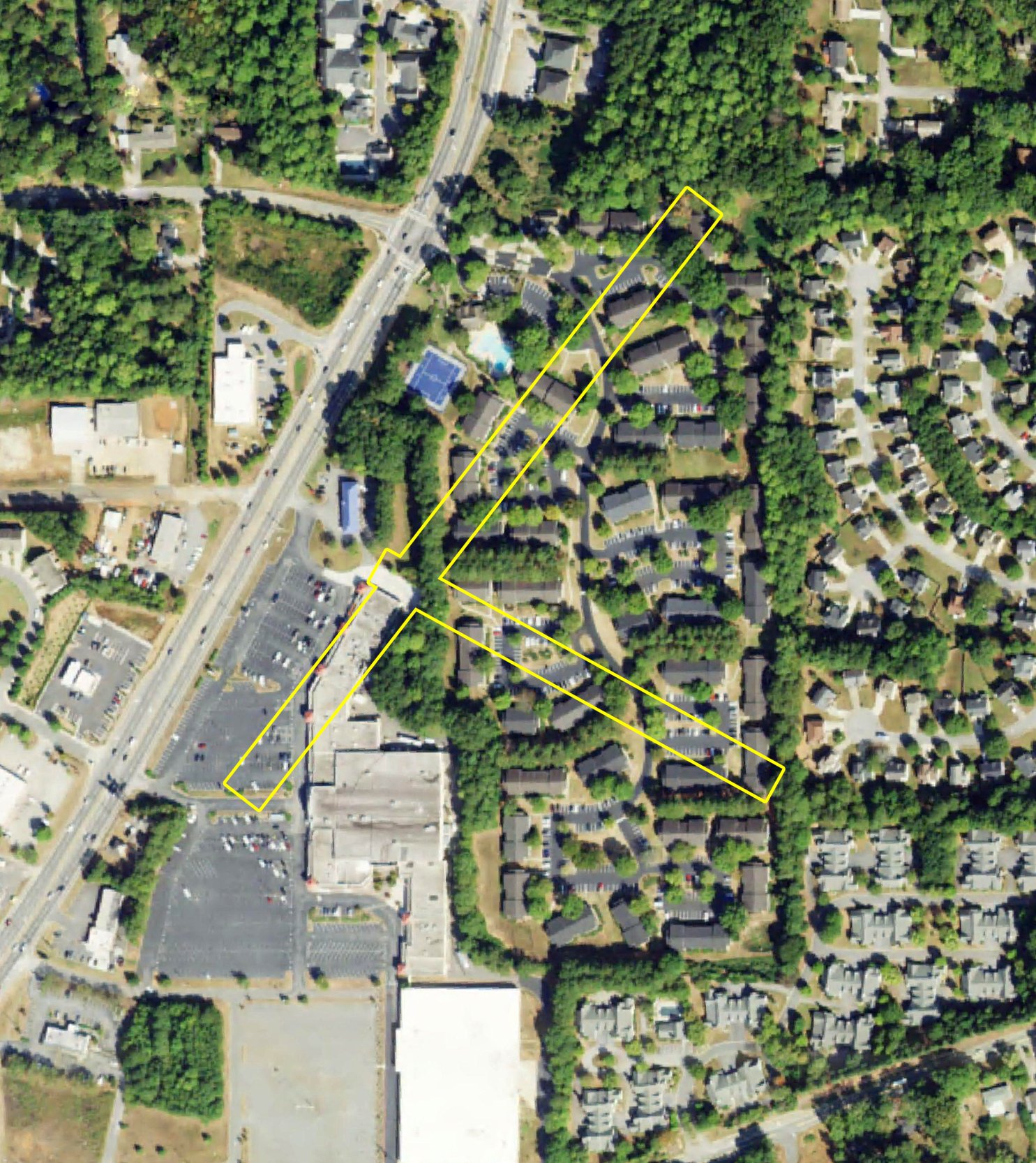
A 2019 aerial view looking north, annotated by David Henderson to show the site of the Cobb Airport runways. No trace of Cobb Airport appeared to remain.
Cobb Airfield was located at the current-day intersection of Austell Road & Station Club Drive.
Thanks to David Henderson for pointing out this airfield.
____________________________________________________
Mathis Airport / Mathis Field (84A, GA27), Suwanee, GA
34.1, -84.162 (Northeast of Atlanta, GA)
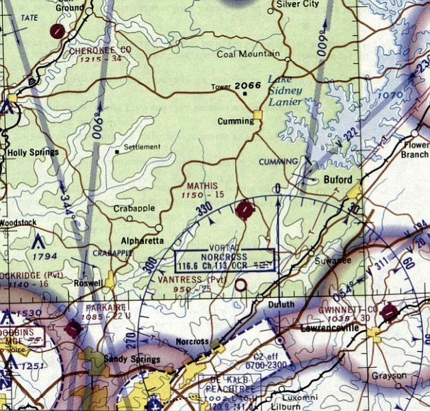
Mathis Airport, as depicted on the August 1967 Chattanooga Sectional Chart.
No airfield was yet depicted at this location on a 1955 aerial view or the 1959 Atlanta Local Chart.
According to Wikipedia, “L.G. Mathis founded Mathis Airport in 1959 as a privately-owned / public-use airport.”
The earliest depiction which has been located of Mathis Airport was a 1963 aerial view,
which depicted it as having a single unpaved northeast/southwest runway, with 1 row of hangars & 1 light single-engine plane on the east side.
Mathis Airport was still not yet depicted on the February 1967 Chattanooga Sectional Chart.
The earliest aeronautical chart depiction which has been located of Mathis Airport was on the August 1967 Chattanooga Sectional Chart,
which depicted Mathis as a public-use airport having a single 1,500' paved northeast/southwest runway.
According to Wikipedia, “In 1979 L.G. Mathis & Patrick McLaughlin began Mathis Airpark as a fly-in residential community adjacent to the airport.”
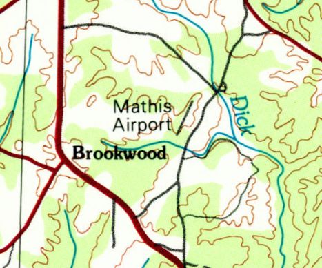
The earliest topo map depiction which has been located of Mathis Airport was on the 1981 USGS topo map,
which depicted it as having a single northeast/southwest runway.
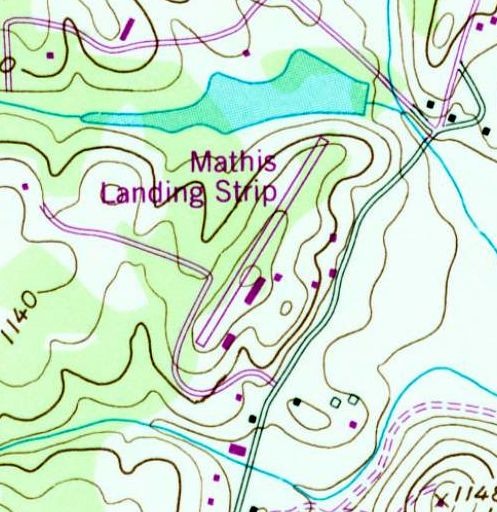
The 1985 USGS topo map depicted “Mathis Landing Strip” as having a single northeast/southwest runway,
with several small buildings on the east side,
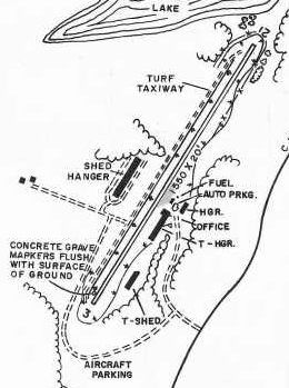
The 1985 GA Airport Directory (courtesy of Charlie Evans) depicted Mathis Airport as having a 1,550' Runway 3/21 with hangars on both sides.
According to Wikipedia, “In 1985 L.G. Mathis sold half of the airport to his brother, C.J.”
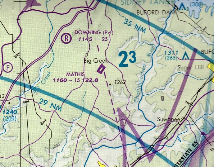
The September 1986 Atlanta Terminal Aeronautical Chart (courtesy of Stu Sibitzky) depicted Mathis as a public-use airport having a single 1,500' paved northeast/southwest runway.
According to Wikipedia, “In 1990 C.J. Mathis bought the remaining half of the airport. In 1992 C.J. sold the airport to 7 Oaks, LLC.”
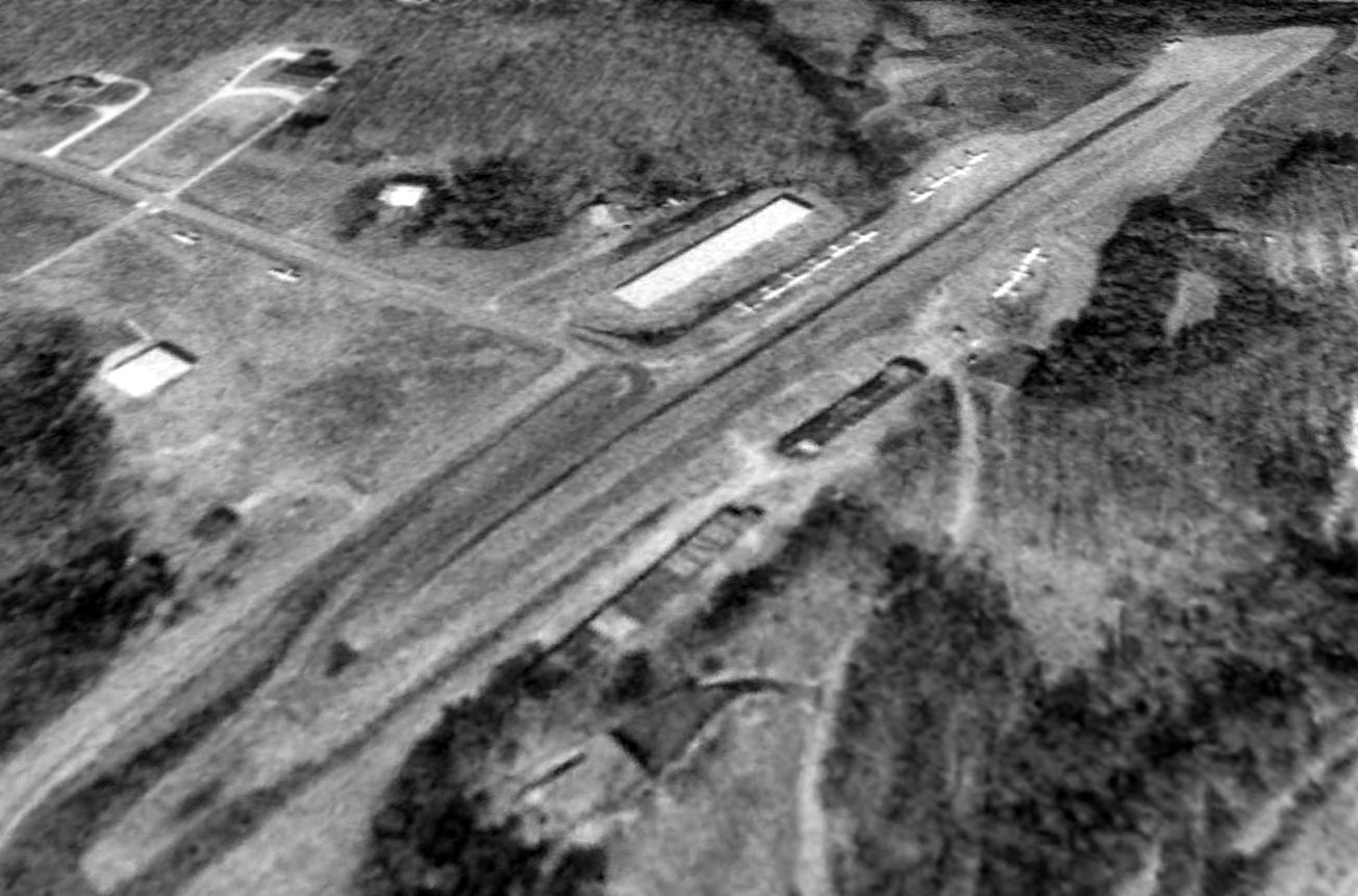
The earliest photo which is available of Mathis Airport was a 1993 USGS aerial view looking northwest. It depicted a total of 15 light single-engine aircraft parked on the airport.
According to Wikipedia, “In 1995, 7 Oaks LLC sold the airport back to C.J. Mathis.”
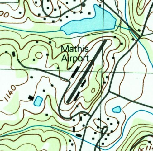
The 1999 USGS topo map depicted Mathis Airport as having a single northeast/southwest runway,
with several rows of hangars on either side of the runway.
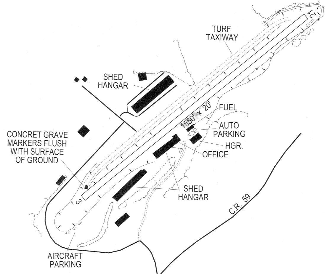
The 2001 GA Airport Directory (courtesy of David Henderson) depicted Mathis Airport as having a 1,550' Runway 3/21, with hangars on both sides.
Note also the depiction of this little airport's most unique feature: “Concrete grave markers flush with surface of ground”.
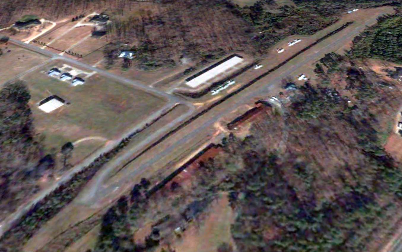
A 2004 aerial view looking northwest depicted a total of 10 light single-engine aircraft parked on either side of the Mathis Airport runway.
According to Wikipedia, “In June 2004 C.J. sold the airport (11 acres) & an adjacent subdivision lot (4 acres) in the airpark to Flyboy Aviation Properties LLC (Flyboy Aviation).
In 2004, Flyboy Aviation expanded the airport in many ways: tore down the original wooden hangars & cinder-block FBO,
added 17 new metal T-hangars, built a new club house, widened & lengthened the asphalt runway, asphalted taxiways & hangar aprons.
From 2004-2009, Mathis was home to Experimental Aircraft Association Chapter 1415,
but in 2009 this chapter moved to Air Acres airport in Woodstock, GA.”
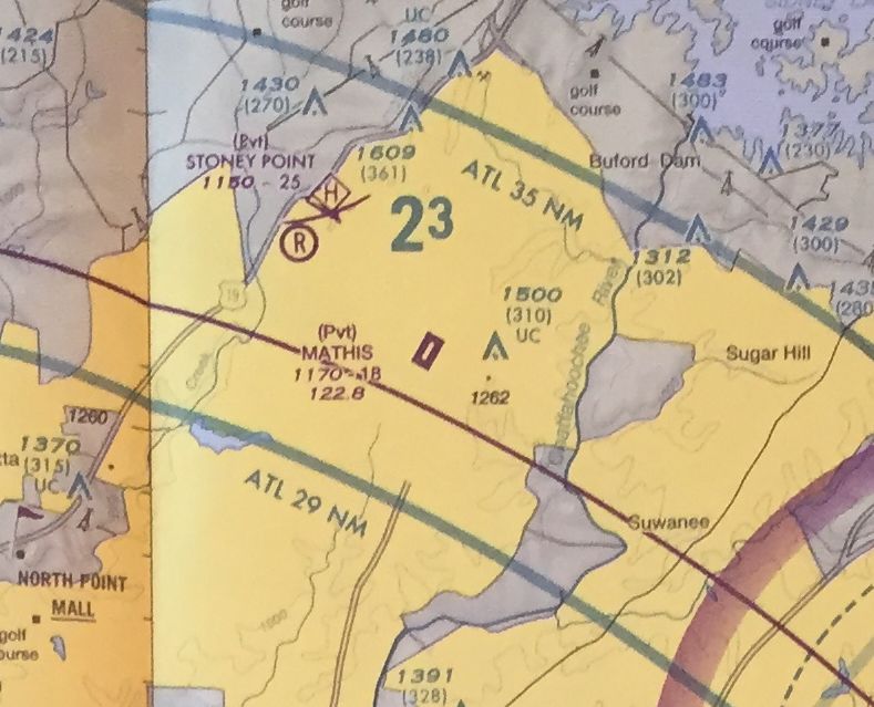
The last aeronautical chart depiction which has been located of Mathis Airport
was on the March 2009 Atlanta Terminal Aeronautical Chart.
It depicted Mathis as a private airfield having a single paved northeast/southwest runway.
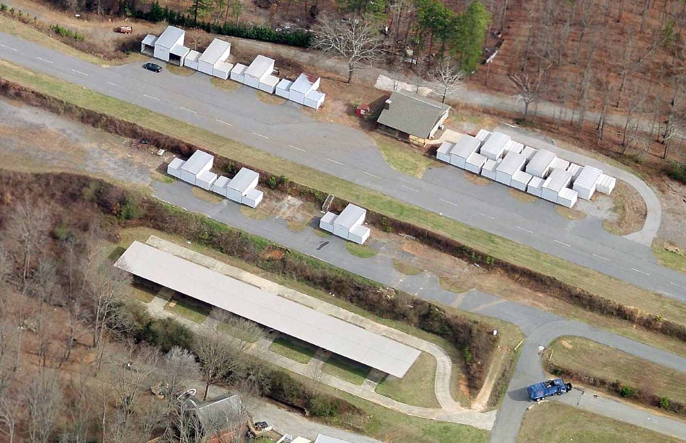
A circa 2010 aerial view looking east showed a considerable number of T-hangars at Mathis Airport, but no aircraft.
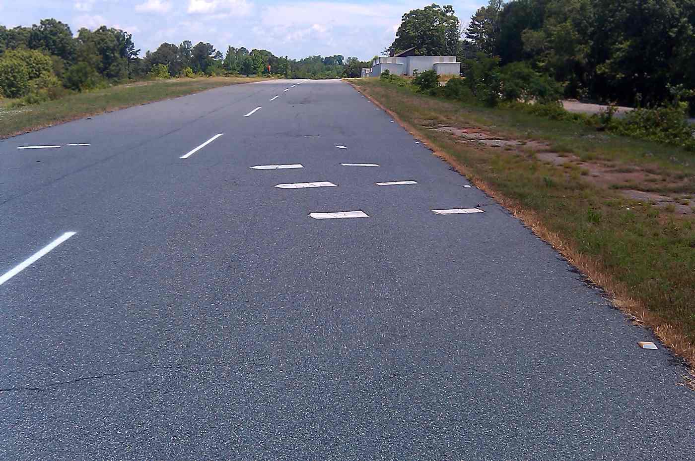
A 2013 photo looking along Mathis Airport's runway, showing perhaps a unique feature – headstones for graves which were flush with the runways surface.
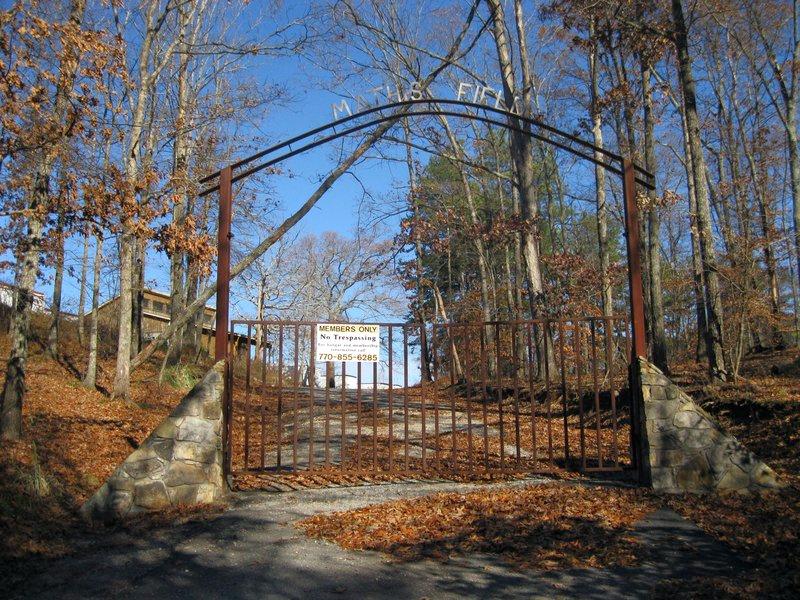
A circa 2014 photo of the entrance gate to Mathis Field.
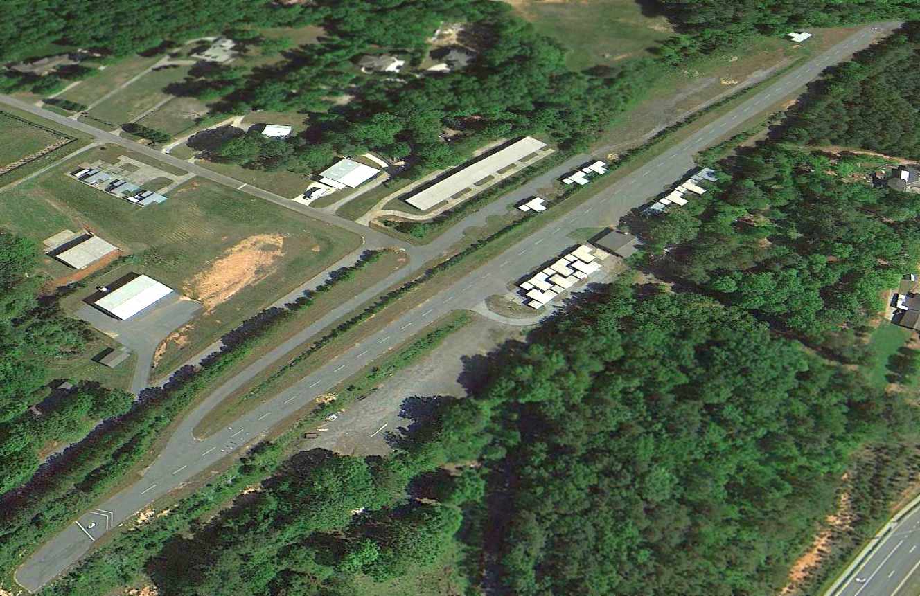
A 2014 aerial view looking northwest showed Mathis Airport remained intact, though devoid of aircraft.
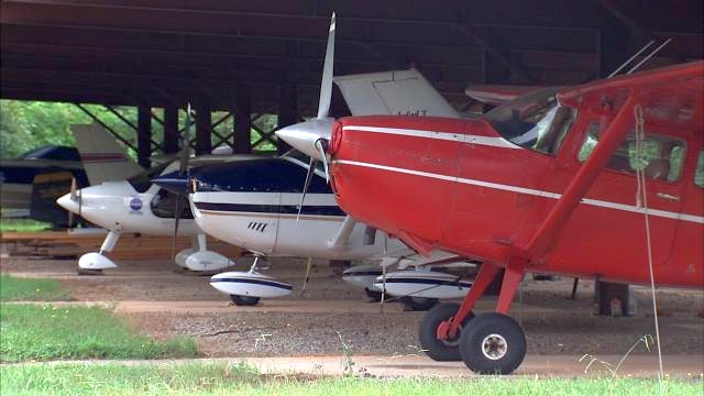
A circa 2014 photo of several planes under a shade hangar at Mathis Airport.
According to its FAA Airport/Facility Directory data, Mathis Airport had an 1,800' asphalt Runway 3/21, and consisted of 11 acres.
According to Wikipedia, “In October 2014 the airport was closed, all hangars [to be] removed & the land [to] be converted to built houses on the property.”
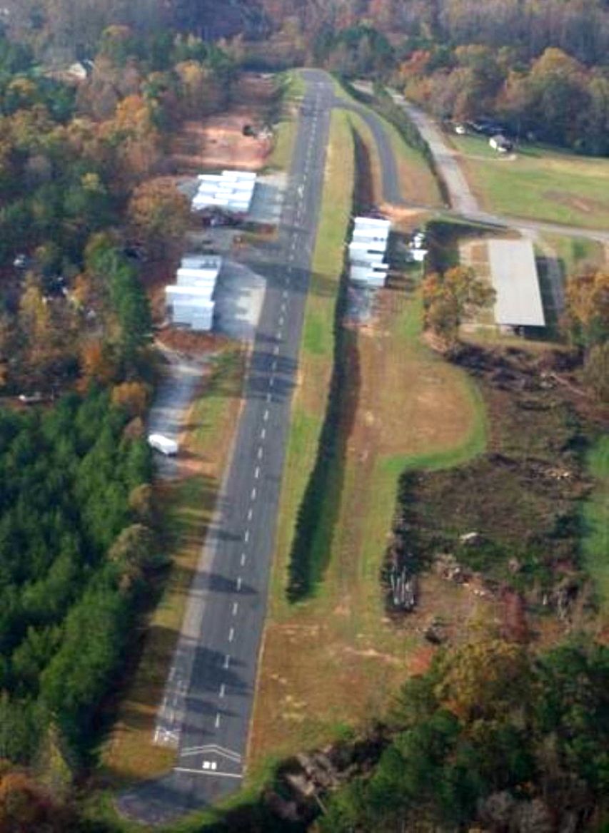
An undated (2015 or earlier) aerial view looking south along the Mathis Airport runway.
Marc Obensahin reported in 2015, “The property is terraced; Mr. Mathis had to do some work to get that runway in there. And it's not a lot.
A coworker said he went up there, years ago, so his son could see the planes & asked someone he met if they gave flight lessons.
The guy said this wasn't the kind of place [where] you wanted to learn to fly.”
Chet Myerson used a UAV on 5/25/15 to record the scene at Mathis Airpark, showing that most of the hangars have been removed,
and yellow closed-runway “X” symbols painted on the runway.
Chet reported, “For 40+ years & a ton of aviation heritage, Mathis Airport in Forsyth County is no more!
The land developers finally got it. In it's heyday (early 2000) it became a member club aerodrome & I flew in there often my the light sport aircraft we were representing.
Soon to be a subdivision, here is a last look at some real aviation history.”
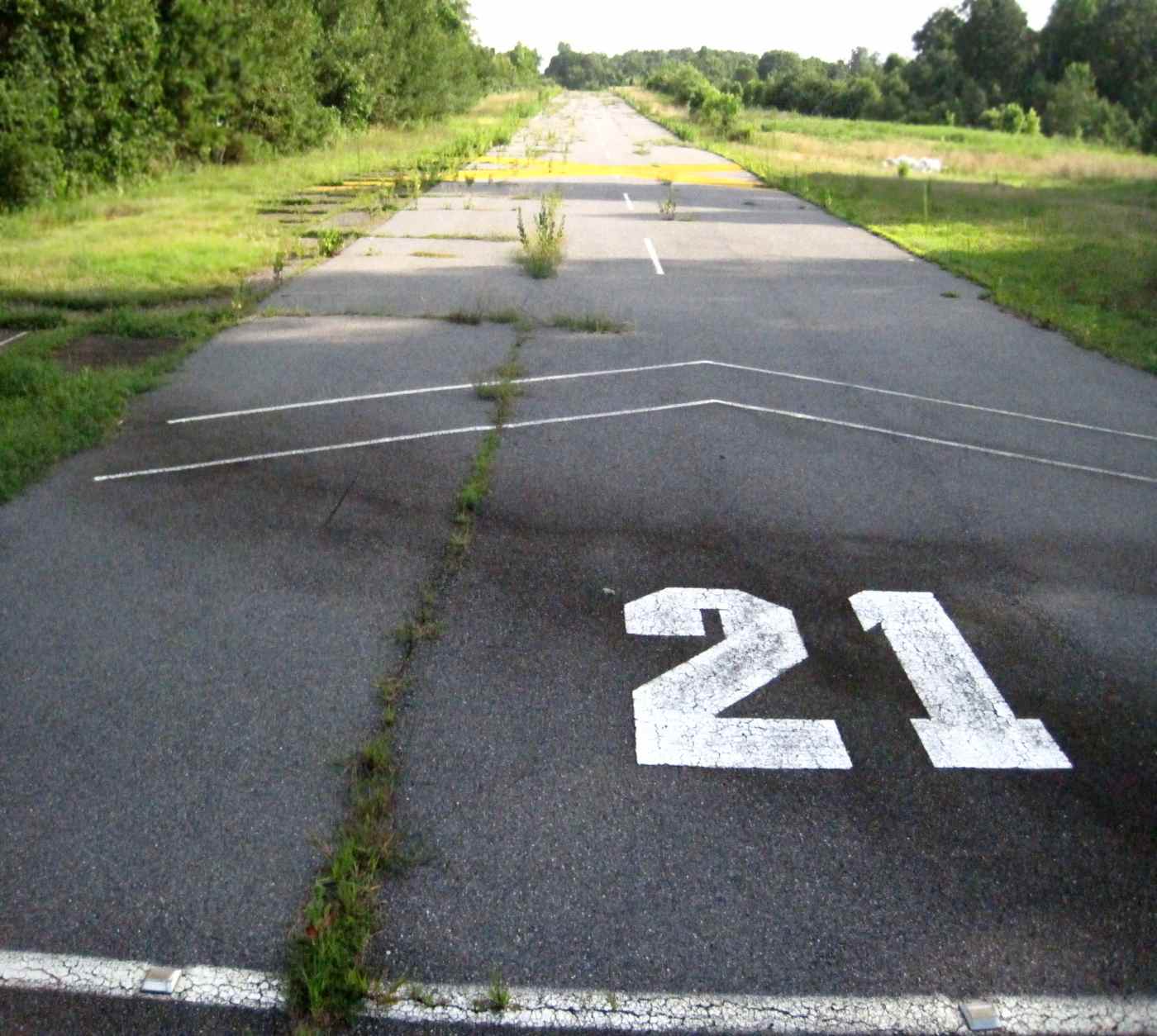
A 7/5/15 photo by Marc Obenshain looking south along Mathis Airport's Runway 21.
Marc observed, “This leaves Forsyth county with a couple of private grass strips, which I'm sure our hyper-development trend will eventually push out, as well.”
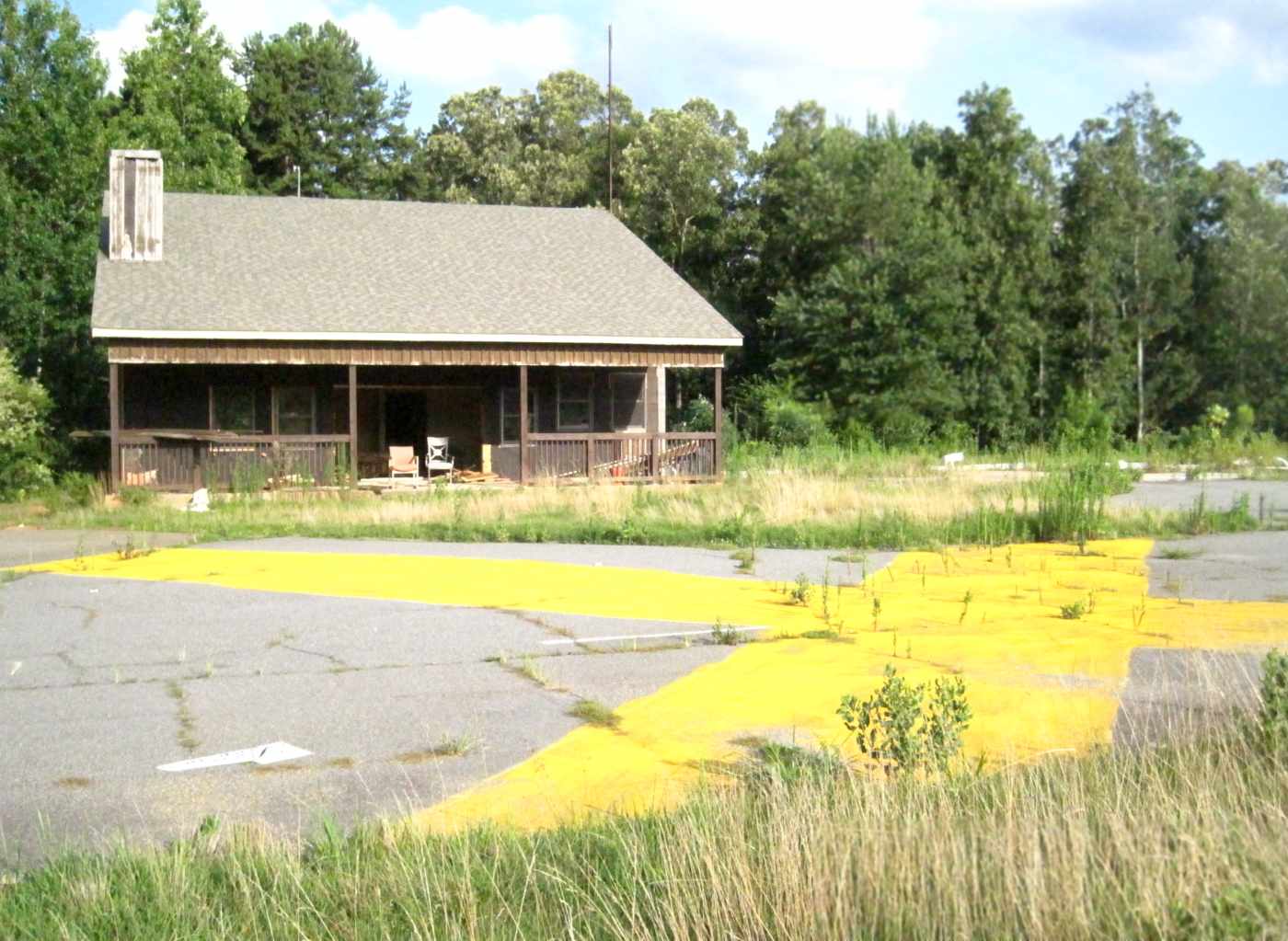
A 7/5/15 photo by Marc Obenshain of the former Mathis Airport clubhouse, with the closed-runway “X” symbol in the foreground.
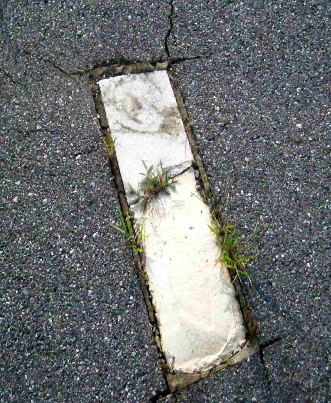
A 7/5/15 photo by Marc Obenshain of Mathis Airport's most unique feature – a grave marker embedded in the runway.
Marc observed this is the “most Northern grave marker - no markings, half missing, half filled with concrete.”
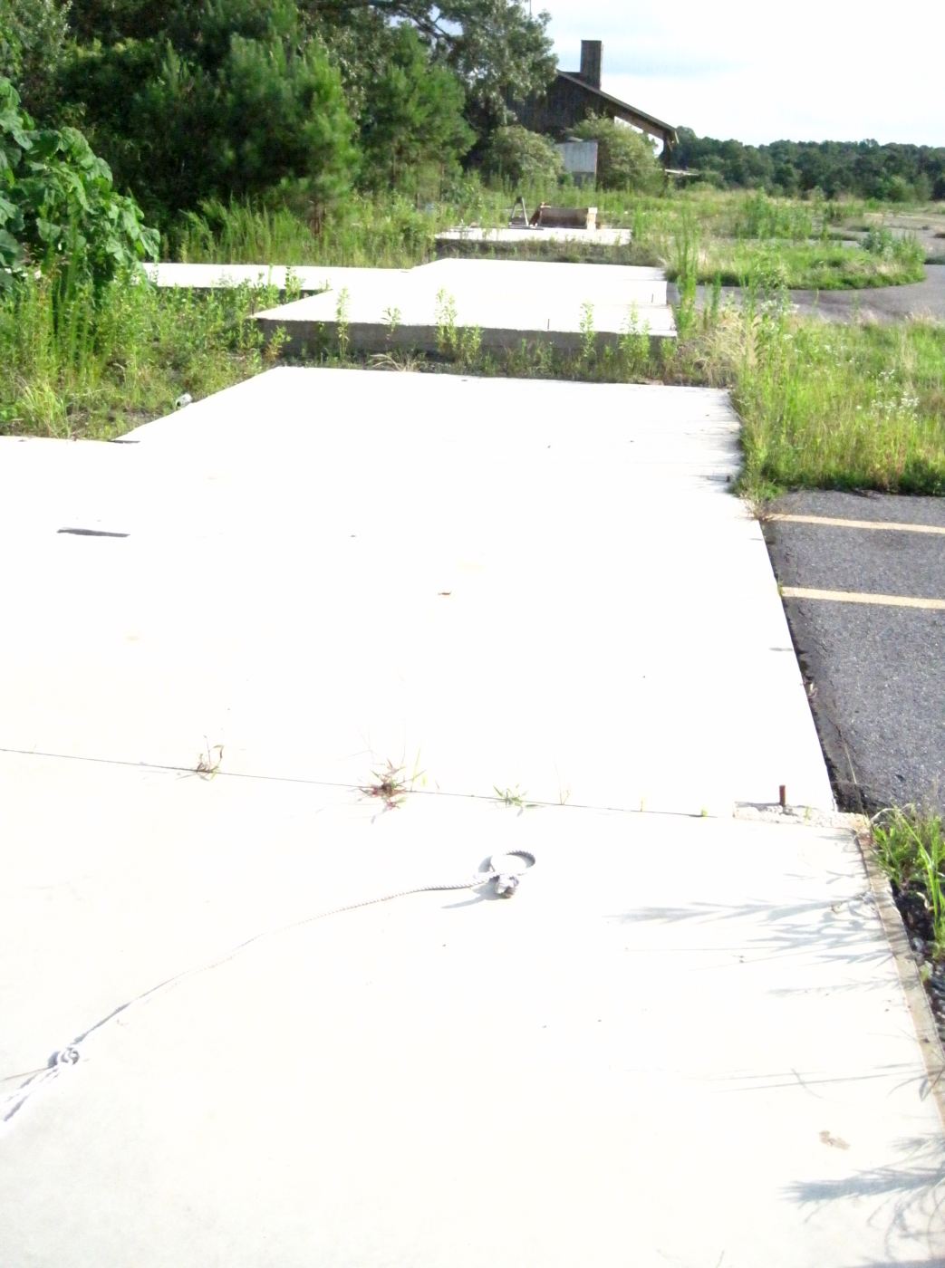
A 7/5/15 photo by Marc Obenshain of Mathis Airport, “Facing South over T-hangar foundations to the North side of the clubhouse.”
A later 2015 aerial view showed construction starting on the Mathis Airport property to build houses.
A 2017 aerial view showed all traces of Mathis Airport had been removed, with houses & streets having been built on the site.
Mathis Airport is located at the northern terminus of Mathis Airport Drive.
Thanks to Marc Obenshain for pointing out this airfield.
____________________________________________________
Cline Ranch Strip (GA81), Social Circle, GA
33.618, -83.782 (East of Atlanta, GA)
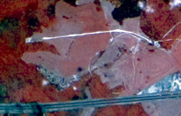
A 1974 infrared aerial photo of Cline Ranch Strip (courtesy of David Henderson).
No airfield was yet depicted at this location on a 1962 aerial photo, the 1966 USGS topo map, or the September 1968 Savannah Sectional Chart.
The single runway airfield was evidently constructed at some point between 1968-74.
David Henderson reported, “Cline Ranch Strip was a private grass airstrip located between Covington & Social Circle, about 35 miles east of Atlanta.
A 1974 infrared aerial clearly showed the runway. It appears as a white stripe north of Interstate I-20.”
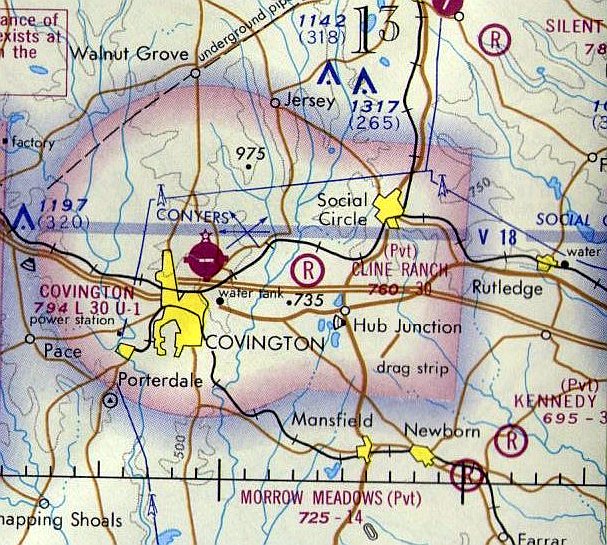
The earliest aeronautical chart depiction which has been located of Cline Ranch Strip was on the 1974 Atlanta Sectional Chart.
It depicted Cline Ranch as a private airfield having a 3,000' unpaved runway.
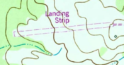
The 1986 USGS topo map depicted Cline Ranch Strip as a single unpaved east/west runway, labeled simply as “Landing Strip”.
David Henderson reported, “In a 2/12/88 aerial photo, the runway appears as an extension of the road leading to the airport.
A building that may have served as a hangar is just south of the field.”
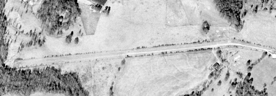
The last photo which has been located showing Cline Ranch Strip still relatively intact was a 2000 aerial view (courtesy of David Henderson).
David Henderson observed, “Trees were beginning to sprout along the runway edges. The runway still appeared to be in good condition.”
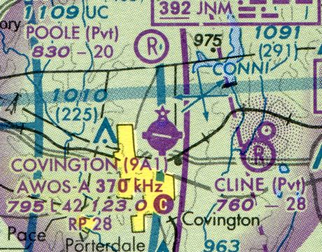
The last aeronautical chart depiction which has been located of Cline Ranch Strip was on the September 2003 Atlanta Sectional Chart (courtesy of David Henderson).
David Henderson observed, it depicted “the runway length as 2,800', down from 3,000' on the 1978 chart.”
David Henderson reported, “By 2005 [an aerial photo showed] the airport was being transformed into the River Cove subdivision with single family houses on multi-acre lots.”
Cline Ranch Strip was no longer depicted on the March 2009 Atlanta Terminal Chart.
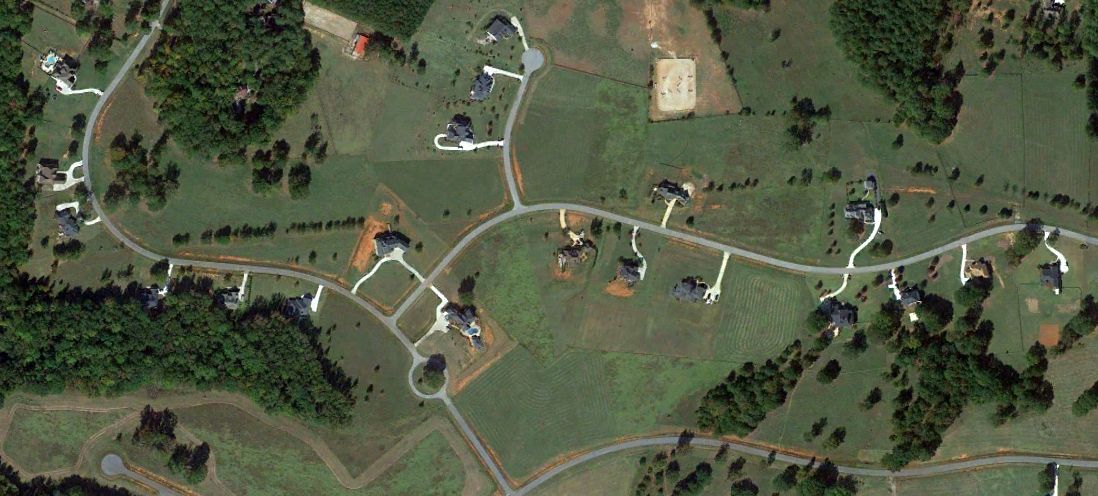
A 2011 aerial view (courtesy of David Henderson) showed that houses covered the site of Cline Ranch Strip, but the alignment of the runway was still barely recognizable.
The site of Cline Ranch Strip is located at the intersection of River Cove Road & River Cove Meadows.
____________________________________________________
Cole Field / Coles Field (GA88), Stockbridge, GA
33.637, -84.207 (Southeast of Atlanta, GA)
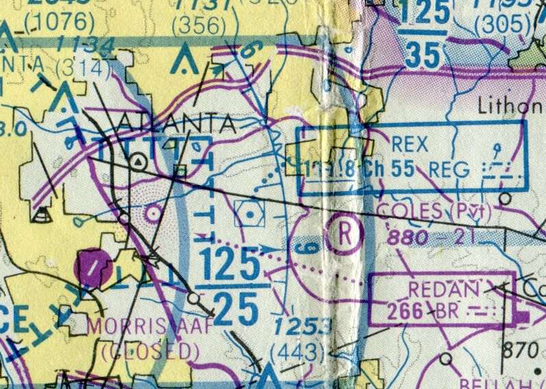
Coles Field, as depicted on the 1978 Atlanta Sectional Chart (courtesy of David Henderson).
Jim Daigneau reported, “Ed Cole grew up on a farm in south Fulton County.
He was featured in the winter, 2020 edition of the Henry County Magazine, from which this information was taken.
After serving in the Merchant Marine & Air Force, Ed & his wife Ruth bought land just south of Panola Road in the mid-1960s.”
Cole Field was not yet depicted on a 1972 aerial photo or the 1975 Atlanta Terminal Aeronautical Chart (according to Jonathan Westerling).
Jim Daigneau continued, “Fortunately, Ed’s father had a beloved D-9 Caterpillar bulldozer. Ed remembered that his father used a compass to help cut the northeast-southwest runway out of the trees.
With a creek running just north of the runway area, there was a fair amount of leveling to do also. Ed remembered that his father had backed into something with the bulldozer.
There were magnesium parts that caught fire & nearly burned the vehicle to the ground.
Fortunately the fire department was able to extinguish the fire, but not before it had caused extensive damage.
Ed helped with the restoration, and with much work & skillful welding, brought the old dozer back to a productive life.”
Jim continued, “Ed remembered that getting the FAA to recognize his airport in the 1970s was a challenge.
There were many pasture runways, especially on the south side of Atlanta, and the FAA likely didn’t want to be bothered.
He said he got a little 6 inch ruler & a pen, went to the county & drew the runway on a county map, basically editing the official plat.
When the FAA said they wouldn’t recognize his airport, he showed them it was right there on the plat.
That’s when it was added to the Sectional chart noted as a private field at 2,100' in length.”
The earliest aeronautical chart depiction which has been located of Cole Field was on the 1978 Atlanta Sectional Chart (courtesy of David Henderson).
It depicted Coles as a private airfield with a 2,100' unpaved runway.
The earliest photo which has been located of Cole Field was a 1978 aerial view.
It depicted Cole Field as having 2 unpaved northeast/southwest runways, with 2 light single-engine aircraft on the northwest side.
There were no buildings on the field.
Cole Field was not yet listed in the 1978 AOPA Airport Directory (according to Jonathan Westerling).
The earliest airfield directory listing which has been located of Cole Field was in the 1979 AOPA Airport Directory (courtesy of Jonathan Westerling).
It described Coles Field as a private airfield having 2 turf runways: 2,100' Runway 8/26 & 1,200' Runway 4/22.
Jim Daigneau reported, “The Coles were very active in EAA Chapter 468.
As an EAA pilot, Ed restored & built small general aviation airplanes both on his own & with the EAA group. Over time, Ed owned an Aeronca Champ & Aeronca Chief.
He built & flew an RLU-1 Breezy homebuilt. Rogers Martin remembered that Ed repurposed Cessna 120 wings for the Breezy.
Ed delighted in giving rides in the Breezy as it was literally 'breezy'.
It would fly at 60 mph & there was no cockpit: the tandem seats were bolted to keel spar & the pilot & passenger were open to the breeze.
When Ed was president, Chapter 468 built a Pietenpol Air Camper but sold the airframe before it was completely finished.
Mary Cole Braun remembered that Ed & her brother built a BD-5 their basement.”
Jim continued, “Ed also was a flight instructor & said that teaching some of the homebuilt aircraft was a special challenge since some models had but one seat.
He remembered a young man had bought a single seat ultalight but had no flying experience. Ed told him to first get used to taxiing & slowly increase speed.
Then, he should get just airborne & fly in ground effect for a bit to get the feel of the controls. Good progress was made & the young pilot was ready to fly.
Ed remembered telling him not to fly too far from the field because everything looked different from the air & trees obscure many landmarks that are easily seen from ground level.
The pilot assured Ed that he was very familiar with the area & subsequently got lost. He did eventually find Cole Field & saw a relieved Ed Cole standing by the runway awaiting his return.”
Cole Field was not depicted at all on the 1981 or 1983 USGS topo maps.
The last airfield directory listing which has been located of Cole Field was in the 1983 AOPA Airport Directory (courtesy of Jonathan Westerling).
It described Coles Field as a private airfield having 2 turf runways: 2,100' Runway 8/26 & 1,200' Runway 4/22.
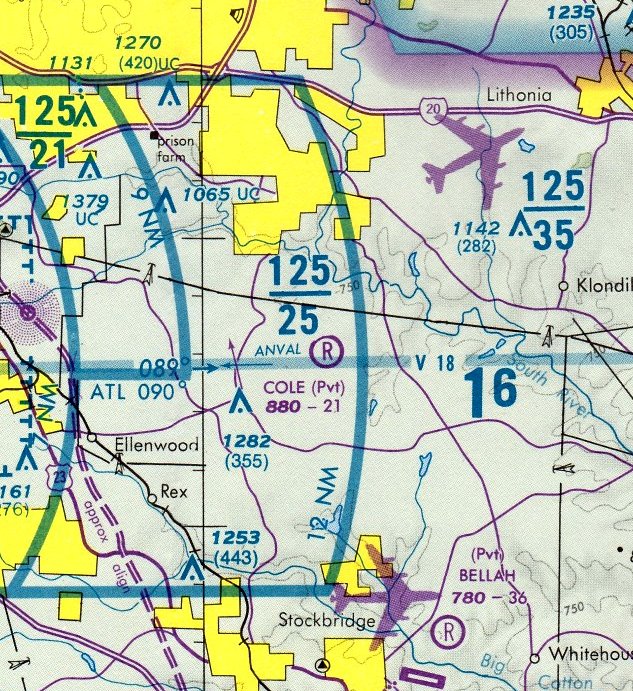
The September 1986 Atlanta Terminal Chart (courtesy of Stu Sibitzky) depicted Cole as a private airfield having a 2,100' unpaved runway.
Cole Field was no longer listed in the 1988 AOPA Airport Directory (according to Jonathan Westerling).
Jim Daigneau reported, “Gloria Barlow remembered that around 1989, she met Bruce Erion, a local reporter at a school event.
At the time, Bruce was the Channel 11 reporter & helicopter pilot (he was also a West Point graduate & Vietnam veteran).
She invited him to fly the 'Channel 11 Alive' helicopter in for the EAA picnic.
He accepted & it was such a success the next year Gloria invited WSB Channel 2 & WAGA Channel 5, Atlanta TV stations with helicopters, to fly in.”
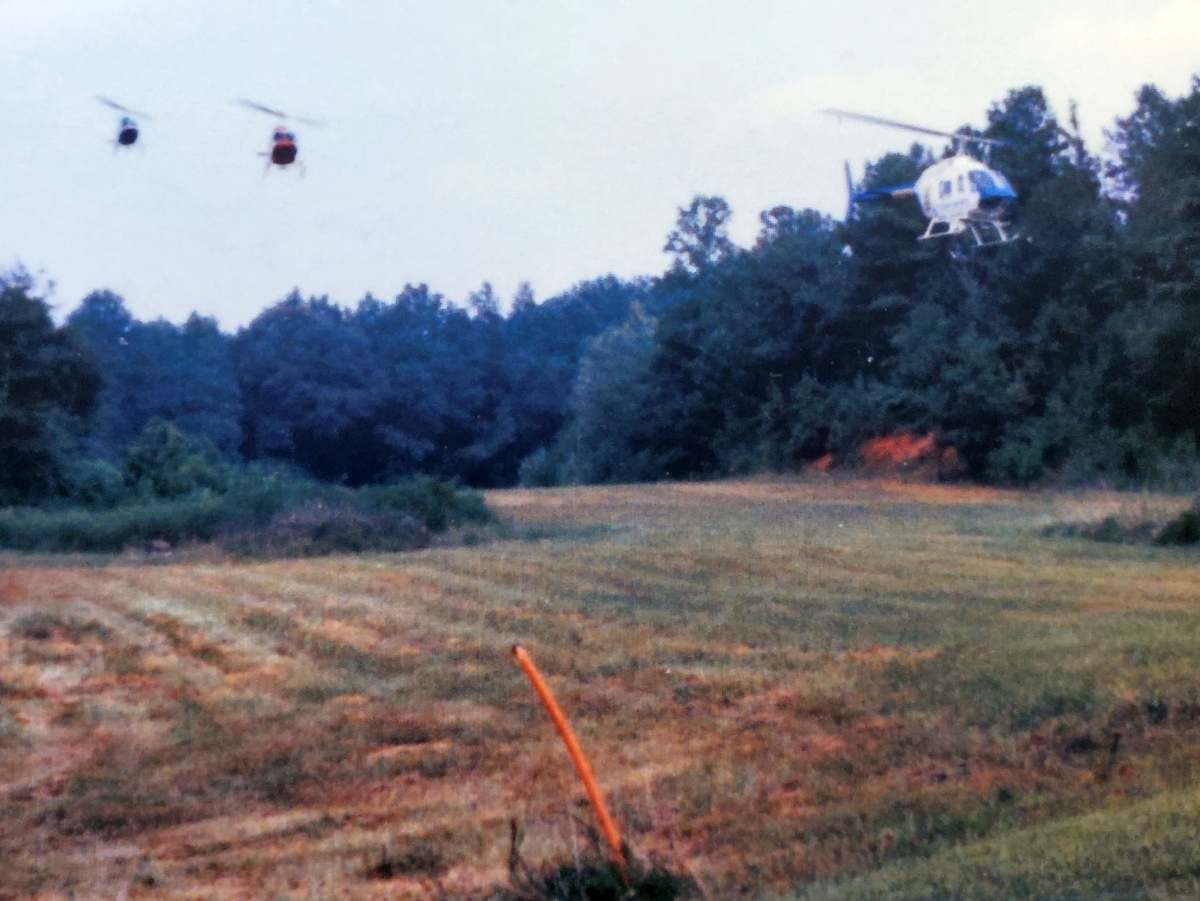
A 1989 photo by Gloria Barlow (courtesy of Jim Daigneau) of 3 Bell JetRangers (news helicopters from Channels 2, 5, and 11) making a formation approach to Cole Field.
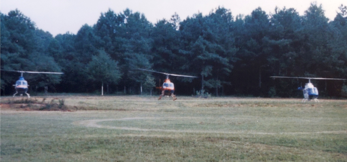
A 1989 photo by Gloria Barlow (courtesy of Jim Daigneau) of 3 Bell JetRangers (news helicopters from Channels 2, 5, and 11) making a formation landing at Cole Field.
Jim Daigneau recalled, “They flew in & landed in formation, conducting a formation bow while hovering just before touching down.”
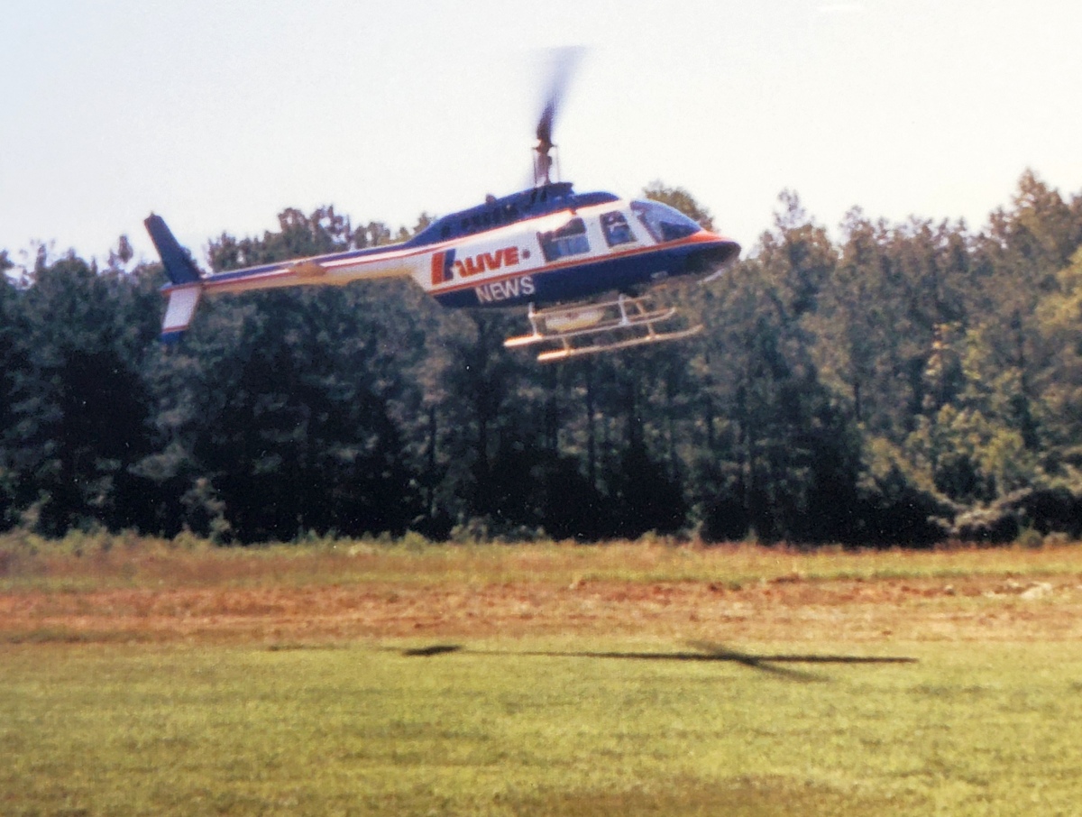
A 1989 photo by Gloria Barlow (courtesy of Jim Daigneau) of the Bell JetRanger from 11 Alive landing at Cole Field.
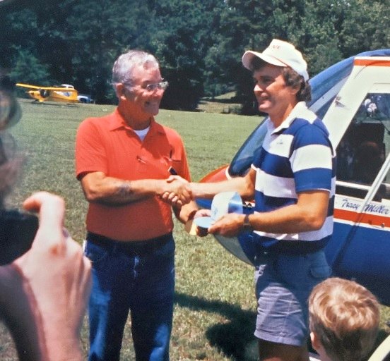
A 1989 photo by Gloria Barlow (courtesy of Jim Daigneau) of Ed Cole presenting Channel 11 reporter Bruce Erion with an EAA ball cap at Cole Field, with Ed’s Cub in the background.
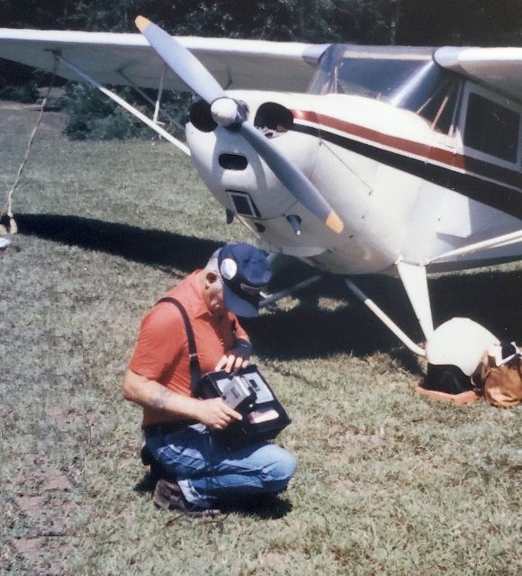
A 1989 photo by Gloria Barlow (courtesy of Jim Daigneau) of Ed Cole with video camera in hand, in front of his Aeronca Chief at Cole Field.
Jim Daigneau reported, “Rogers Martin remembered flying into to Ed’s field to pick up one or two of Ed’s daughters to take them flying.
For one such excursion, Rogers was flying a Cessna 206 for a local construction company & flew into to Cole Field.
Ed was a little concerned that Rogers would not be able to the relatively large airplane safely over the trees.
Rogers said, with a light load, the airplane handled the confines of Cole Field with no problem.
Rogers Martin grew up and flew out of his father’s Sunset Strip, just a few miles to the west of Cole Field.”
Jim continued, “Ed [reluctantly] remembered a story about propping his Aeronca Chief.
He had found a bird’s nest in the intake & cleaned it out before he started up to go flying. He throttled up at the end of the runway to pivot around for takeoff.
As he turned he smelled smoke & immediately cut the mags off to kill the engine. He went out to inspect the engine again but realized it was 'his neighbors were burning weeds.'
Relieved, he went back to turn the mags on but didn’t adjust the throttle. When he pulled the prop through it started up & immediately started to move forward with the extra throttle.
Ed couldn’t get to the door so he just held on to the strut to get one wheel off the ground.
As he drug the airplane around in circles, he looked at the windsock & figured 'if he let go at the right time, the airplane would take itself into the pine trees & not the neighbor’s house.'
It was a good plan: when he let go he was able to get to the door & pull the throttle back & kill the engine. He then 'looked around to see if anyone had seen' the proceedings.”
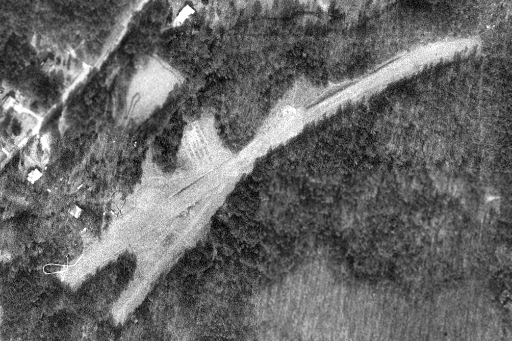
The last photo which has been located of Cole Field was a 1993 aerial view.
The 2 unpaved northeast/southwest runways were still intact, but the airfield may have been closed by that point, as there were no aircraft visible on the field.
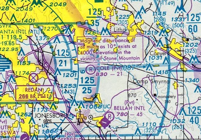
The last aeronautical chart depiction which has been located of Cole Field was on the March 1995 Atlanta Sectional Chart.
It depicted Cole as a private airfield having a 2,100' unpaved runway.
Jim Daigneau reported, “Ed sold the property in 1997. It was quickly converted into the current Waverly Place subdivision: a fate common to many small, private airfields.”
A 1999 aerial photo showed the housing development having erased all traces of Cole Field.
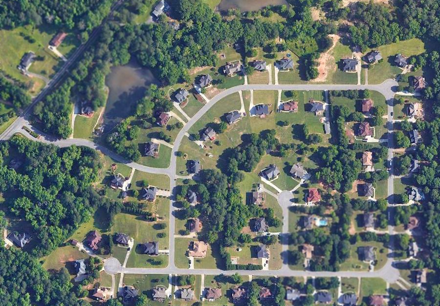
A 2018 aerial photo showed no trace of Cole Field.
Jim Daigneau reported, “Ed & Ruth’s old home is still visible on the south corner of Waverly Boulevard & Panola Road.”
____________________________________________________
33.965, -84.41 (Northeast of Atlanta, GA)
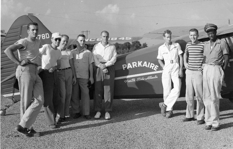
A 1946 photo of a group including Jack Dunn (2nd from right) at Parkaire Field in front of a Stinson Voyager 108-2 which had been newly-painted with the Parkaire logo.
According to the 1966 “Atlanta Metropolitan Region Comprehensive Plan” (courtesy of David Henderson), Parkaire Field was built in 1945.
According to Phil Bonner Jr., "Walt Nix bought the property around 1946 after being a Captain in the Army Air Corps
in which he met a fellow whose dad owned a new company called Piper Aircraft.
Walt became the southeast distributor for Piper & made good money in the aviation boom of the era.”
The earliest photo which has been located of Parkaire Field was a 1946 photo of a group including Jack Dunn
in front of a Stinson Voyager 108-2 which had been newly-painted with the Parkaire logo.
Parkaire Field was not yet depicted on the April 1946 Birmingham Sectional Chart.
Patricia Ovbey Thomas recalled, “I flew out of Parkaire many times as a child of about 7-8 years old in about 1946-50
when Jack Dunn (who became a test pilot for the C-5A) & Pete Davidson were managers.
Bobby Moor, one of 3-4 pilots out at Parkaire, flew out of there & flew my 2 siblings & I
as trade-off for my dad's repair services to maintenance equipment in the shop at the airport.
The shop was full of tools that used air compressors to operate them & Dad, Tim Ovbey, could fix about anything that was broken.
Dad had virtigo & couldn't fly so they took us kids up. My first trip up was in the Red Cherokee!
Bobby was one of the pilots for hire for the planes chartered around the area for trips to from Atlanta & pleasure & entertainment.
The Chattahoochee River would rise & flood over it's many bridges, no Bufford dam at that time,
and folks wanted to come out of Atlanta to their weekend homes
and Parkaire air service became very popular for the doctors & Atlanta store owners who had weekend homes on Bishop's Lake & Mountain Park.”
Patricia continued, “They'd leave Candler Field in Atlanta & fly out to Parkaire.
At that time in my life, I began a love affair for small planes, small airports & anything that flew!
Bobby Moor had a history. He loved to perform & did tail spins over our house for 3-4 years. He'd fly low enough for us to talk.
Jack Dunn went to Lockheed & not sure where Pete Davidson & family went.
The road near Parkaire, Davidson Road was named for Pete, as his house sat over to the side & the road started as his driveway!
Yes, I became an incurable airport & airplane junkie from a bunch of sweet guys
that put up with a little curious girl & her siblngs who were crammed in the back seat of those baby planes.”
Patricia continued, “My brother, Jim Ovbey, who was younger than me; he got to sit in front every now & then, next to Bobby.
We'd take the Piper Cubs out most of the time & one of them had a missing passenger door
and he sat & strapped Jim into that doorless plane & those blue eyes got really big & that head full of blond straight hair swished all around
as he looked & asked hundreds of questions!
Bobby told him 'We use this one to take pictures' Jim, you can see better, also.
Bobby laughed his boyish laugh & revved up that engine as he loved to so we would shutter just a little & he knew that.
He'd ask us if we liked to hear that & we told him it was scarey; that's all Bobby needed because he was nothing but a tease.
When we got airborne, he tipped that doorless plane on its side & told Jim to look out & asked Jim what do you see;
Jim told him he could see the river & some houses. We were at the Chattahoochee.”
Patricia continued, “We lived a mile down on the other side of Johnson's Ferry Road on Roswell Road
and Dad worked in Buckhead at that time & often stopped in at the airfield to see if anything was broken or out of operation before he came home.
Those guys were his buddies & between Dad & Bobby, who were the cutups, there were always tricks on the other guys going on.
Pete & Jack were more serious, more refined, officers & gentlemen of the military, thank you.
So you see why I liked to go up to Parkaire, I loved the laughter of guys,
those deep, loud laughs that tell kids things are all right even with a war going on or just coming to an end, somewhere in the world.”
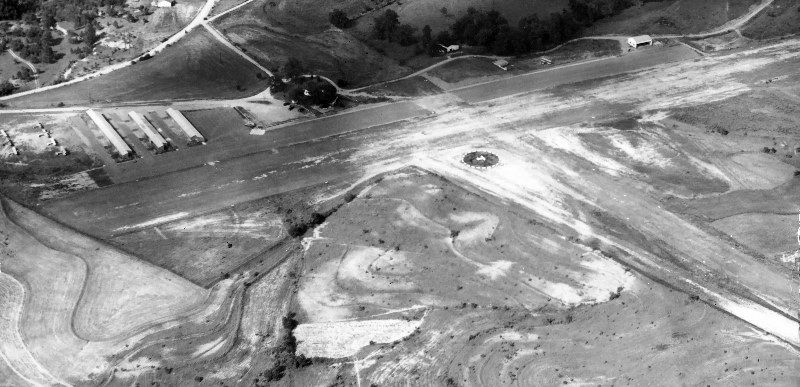
A 1947 aerial view by Jack Dunn depicted Parkaire Field as having 2 unpaved runways, with 3 rows of T-hangars on the northwest side of the field.
Joe Rao recalled, “When I was at GA Tech 1947-51, the Tech flying club flew out of Parkaire.
The aircraft I flew there there were: Ercoupe NC94761, Aeronca Champ NC1650E, Cub J-3 NC40605,
Cub Cruiser NC2824M, Cessna 120 NC2217N, Cessna 140 NC77011, Stearman PT-17 NC1208M (Donated by the Navy).
I know the PT-17 & Champ were owned by the club, the others by the FBO.”
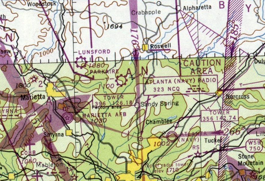
The earliest aeronautical chart depiction which has been located of Parkaire Field was on the October 1948 Birmingham Sectional Chart.
It depicted Parkaire as a commercial/municipal airport.
Alan Dameron reported, “I have a letter & invoice dated 1949 from Parkaire Field listing the owners as Hal Davison & Peter Davison.
Dad kept his Stearman tied down at Parkaire.”
According to Phil Bonner Jr., "Walt Nix was like an uncle to me & taught my dad Phil Bonner to fly there around 1951 or so."
Ed Leonard recalled, “I took flying lessons as a 17-year-old at Parkaire in 1951.
The next year my father bought a Bellanca & kept it at Parkaire.
Walter & Kitty Nix owned & operated the field during the early 1950s.
Although Walt was a licensed instructor, I took my lessons from his 22-year-old employee, Johnny Orr.
The 2,200' main runway was dirt, but there was, of all things, a paved taxiway along its north side.
Once when I was there, a DC-3 (which did not try to make contact by Unicom) wanted to land.
It kept making approaches to the narrow, somewhat obstructed, paved taxiway.
We tried to wave it over to the dirt runway, and finally succeeded.
The 1,800' cross runway was dirt, and had a LARGE tree partly obstructing the south approach.”
Ed continued, “There were several incidents at Parkaire.
The biggest one was a tornado (!) which damaged the T-hangars & several of the planes.
Another was in fall of 1952 when my father was practicing precision landings,
landed short, turned the Bellanca up on its nose, and broke off one of its (wooden) wings. He was not injured.
Flying was exciting (and inexpensive) in the early 1950s!”
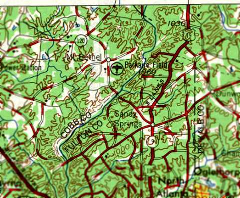
Parkaire Field, as depicted on the 1953 USGS topo map.
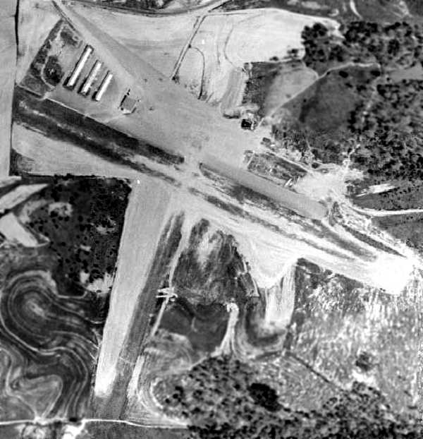
A 1955 aerial view depicted Parkaire Field as having 2 unpaved runways, with 3 rows of T-hangars on the northwest side of the field.
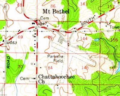
The 1955 USGS topo map depicted Parkaire Field as having 2 unpaved runways.
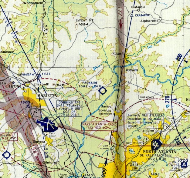
The 1959 Atlanta Local Aeronautical Chart (courtesy of Tim Zukas) depicted Parkaire as having a 2,400' unpaved runway.
In 1959, a meeting was held at at Parkaire Field to reorganize the North Georgia Soaring Society (NoGass).
The Club purchased a Schweizer 2-22 for the sum of $2,000.
A flying fee of 3 cents/minute & a tow fee of $1.00 / thousand feet was established.
The operator of Parkaire, Walter Nix, agreed to let the club operate at Parkaire Field.
Parkaire had evidently gained a paved runway at some point between 1955-60,
as a 1960 aerial view depicted a paved northwest/southeast runway.
Several buildings & hangars had also been added along the north side of the field.
There were a total of a dozen light aircraft visible on the field.
In the Spring of 1962 the North Georgia Soaring Society's 2-22 was flipped & destroyed in a windstorm at Parkaire
and as a result, flying activity by the soaring club was severely curtailed.
In the late Spring of 1962 the NoGass Club & MGSA Club were merged
and continued to operate from Parkaire Field under the MGSA name.
Later members of the club constructed a new airfield at Monroe, GA airport,
and moved their operations there,
as suburban development was beginning to encroach on Parkaire Field.
Parkaire had evidently gained a paved runway at some point between 1954-62,
as the 1962 AOPA Airport Directory described Parkaire Field
as having a 2,200' asphalt Runway 12/30 & a 2,000' sod Runway 18/36.
The operator was listed as Walter Nix.
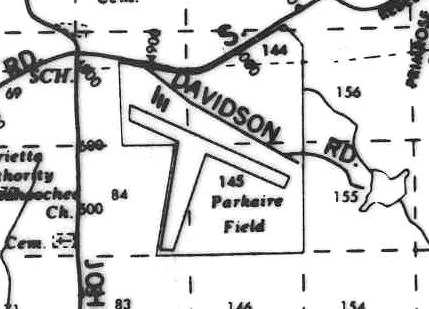
A 1964 street map (courtesy of Robert Brown) still depicted Parkaire as having two runways.
According to the 1966 “Atlanta Metropolitan Region Comprehensive Plan” (courtesy of David Henderson),
“In 1965, these aircraft were reported based at the airport: single-engine, 1-3 places (9);
single-engine, 4 or more places (19).”
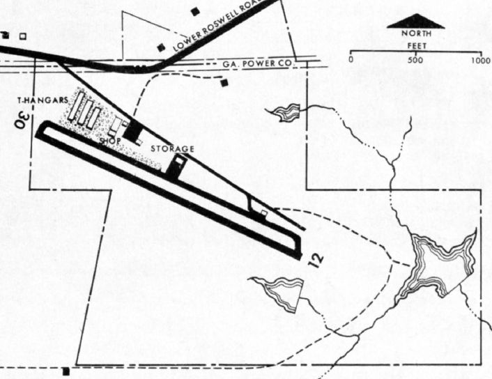
The 1966 “Atlanta Metropolitan Region Comprehensive Plan” (courtesy of David Henderson)
depicted Parkaire Field as having a single Runway 12/30, with T-hangars & a shop on the northwest side.
According to the 1966 “Atlanta Metropolitan Region Comprehensive Plan” (courtesy of David Henderson),
“Parkaire is the oldest of the privately-owned general aviation fields in the region.
In recent years residential subdivision development has begun in the general vicinity of the field.
The 74-acre site is not suitable for airport expansion.
Nearby development prevents runway extension to the west, while to the east the land falls off sharply toward the Chattahoochee River.
The single runway is 2,200' long, with pavement 40' wide;
it & the associated taxiway & apron are in good condition but are not lighted, and the field is attended only during daylight hours.
Although open to the public, Parkaire is maintained primarily as a necessary adjunct to an aircraft distributorship, principal business of the owner.
There is underground storage for 4,000 gallons of aviation gasoline.
The following facilities & services are also available: Major & minor repairs to power plant, airframe, instruments & accessories,
Aircraft services: washing & waxing, Aircraft storage: T-hangars 22 spaces, Tie-down 5 spaces,
Sales of new aircraft, engines, instruments, radios, Sales of used aircraft,
Flight instruction for all ratings available by special arrangement.”
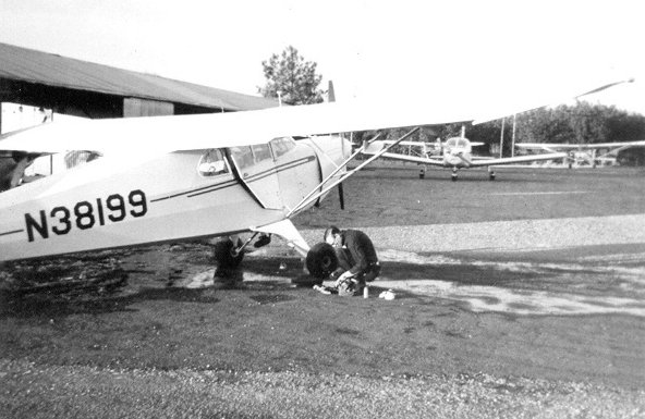
A circa 1968 photo of Roger Truelove & Tom Sieswerda's Piper J-4E Cub in front of a Parkaire hangar.
Tom Sieswerda recalled, “I had a Piper J-4E there in Hangar 2 from 1966-70.
Perhaps 1968 we had Charlie Hillard & Gene Soucy fly in, before the Red Devils.”
Joe Price recalled, “In 1968 I experienced my first small plane flights from its runway
in the local Civil Air Patrol squadron’s Aeronca L-16 & in Noel DeChar’s clipped-wing Piper J-3.”
A 1968 aerial view depicted Parkaire at perhaps the zenith of its popularity,
with over 30 light aircraft visible on the field.
The 1968 Flight Guide (courtesy of Robert Levittan) depicted Parkaire Field as having a single paved 2,200' Runway 12/30,
as well as a parallel taxiway on the north side leading to a long ramp.
A total of 10 buildings were situated on the north side of the ramp.
Andrew Croft recalled, “Parkaire in Marietta.. my Dad used to work on a J3 there that he restored.
I flew in & out of there many times & it could get pretty scary.
here was high-tension power lines on one end & almost a cliff on the other, you would disappear over a hill on take off.
The power lines were lowered with orange balls on them & the last time I was there they still ran across the shopping center parking lot.”
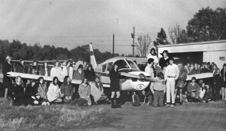
A circa 1970-71 photo (courtesy of Joe Price) of students around an unidentified aircraft at Parkaire Field
from North Springs High School’s 1971 yearbook.
According to Joe, “The American Field Service did its annual spread there in late 1970 or early 1971.”
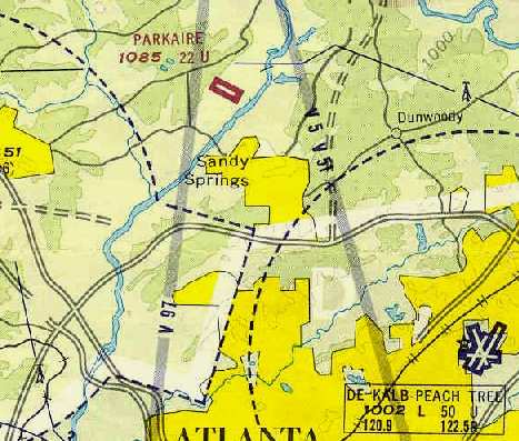
Parkaire was still depicted as an active airfield on the 1971 Atlanta Sectional Chart (courtesy of Robert Brown),
which depicted the field as having a single 2,200' paved runway.
According to Phil Bonner Jr., "Walt Nix… sold the airstrip around 1972."
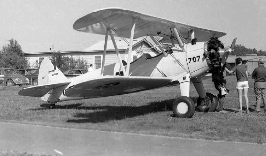
A Summer 1972 photo by Robert Brown of “Gordon Dunnagan's Stearman from PDK visiting Parkaire to shoot landings.
If you've ever been to PDK you'll understand why it wasn't practical to shoot landings in a Stearman there.”
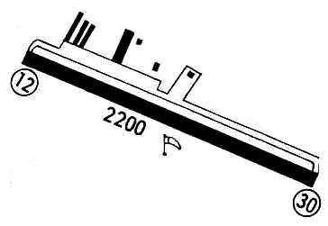
The 1972 Flight Guide (courtesy of Chris Kennedy) depicted Parkaire Field as having a single 2,200' paved Runway 12/30,
as well as a parallel taxiway on the north side leading to a long ramp.
A total of 7 buildings were situated on the north side of the ramp.
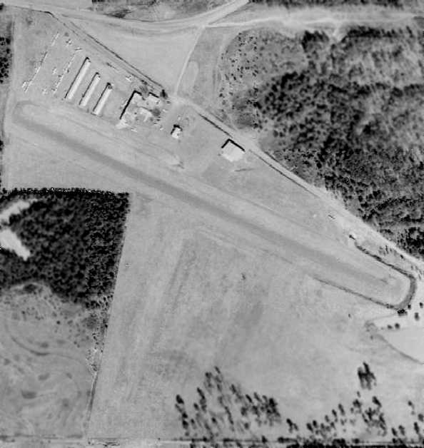
The last photo which has been located showing Parkaire Field in operation was a 1972 aerial view.
A total of 25 light aircraft were parked at the northwest corner of the field.
A 5/17/72 article entitled “Cobb Airport Sold, Homes Due” (courtesy of David Henderson)
described how Sharp-Boyleston Company announced that Parkaire Field had been sold for almost $1 million to Post Properties,
which planned to build 500 condominium units on the land, with development to begin in 6 months.
Parkaire Field was closed at some point during 1972.
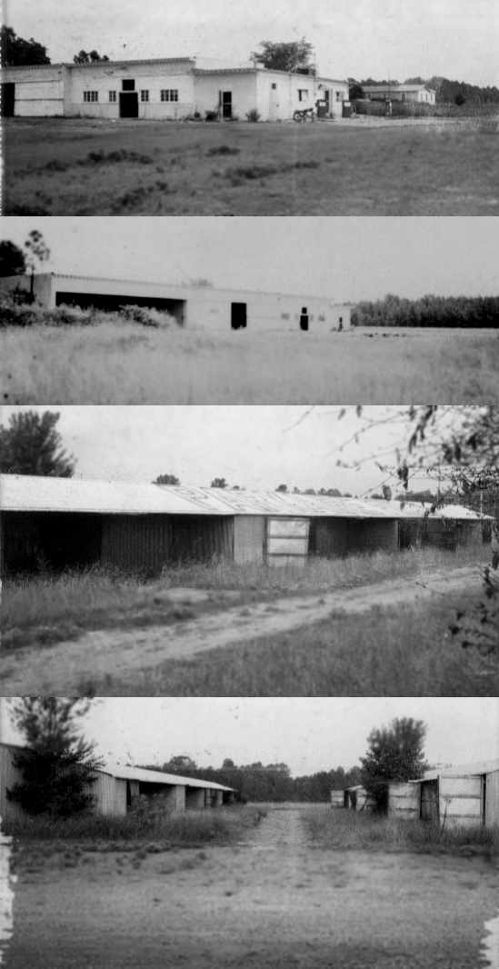
A series of August 1972 photos of the abandoned Parkaire Field by Joe Price.
Joe recalled, “I motorcycled to the site on 8/27/72, shot the black & whites, then had the presence of mind to map the shoot.
The photos show a distinct ghost town quality; the overgrowth suggests it had been abandoned since spring of that year, possibly before.”
The top picture depicted the main operations building.
Joe observed, “The office was on the right next to the fuel pumps. Building 'C' is in the background, but I don’t know what its use was.”
The second picture is of the main operations & maintenance building.
The third picture is of the southern end of Hangar 2 (note “Parkaire Field” painted on the roof. The last picture is of Hangars 1 & 2.
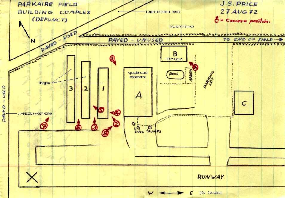
A layout by Joe Price of the arrangement of Parkaire Field as it existed in August 1972.
Patrick Burchins recalled, “Parkaire Field... In 1973, my family moved to Georgia from Florida
and my father was the General Superintendent for Holder Construction on the Parkaire Project.
Between Summer of 1973 & 1974 my dad was in charge of demolishing & new construction
of a mall with an ice skating rink in the middle of it & a Kroger grocery store attached.”
According to Robert Brown, "Parkaire was replaced by Parkaire Mall.
Davidson Rd was the access road to the airport & the runway ran parallel to it.
When the mall was first built, there was a section of runway still visible but the original mall was torn down & replaced by a new one
and the whole area has been developed more."
Parkaire was no longer depicted on the April 1974 Atlanta Sectional Chart (according to Chris Kennedy).
A 1978 aerial photo appeared to show no trace remaining of the airport.
Patrick Burchins reported in 2009, “There is one thing left from the old Parkaire Field.
There are large red cones attached to the high-tension wires for the power company warning the aviators that were landing at the old airport.”
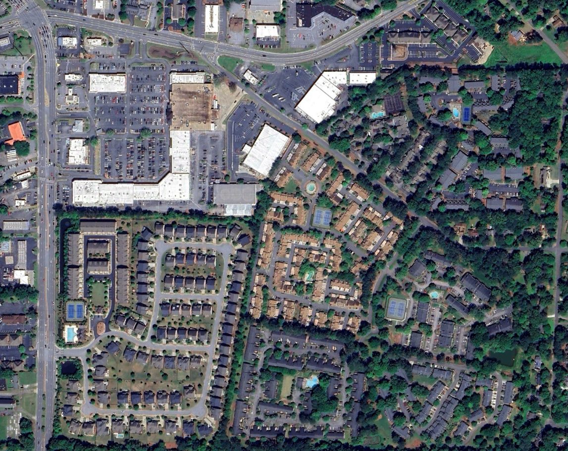
As seen in a 2023 aerial photo, the site of Parkaire Field has been densely redeveloped.
The site of Parkaire Field is located southeast of the intersection of Lower Roswell Road & Davidson Road.
____________________________________________________
Stone Mountain Britt Memorial Airport (00A), Stone Mountain, GA
33.813, -84.12 (East of Atlanta, GA)
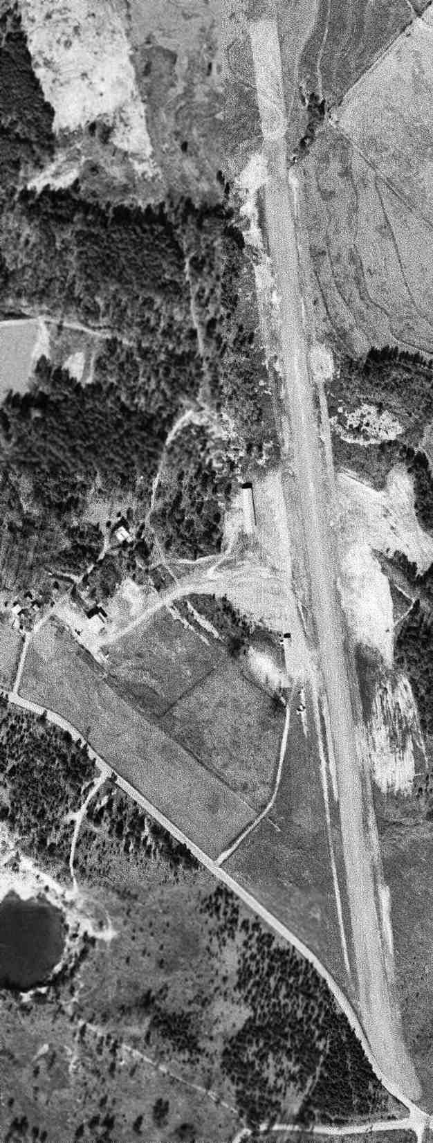
Stone Mountain Airport, as depicted on a 1959 USGS aerial photo (courtesy of David Henderson).
This general aviation airport was not yet depicted on a 1955 aerial photo.
According to the 1966 “Atlanta Metropolitan Region Comprehensive Plan” (courtesy of David Henderson),
“Stone Mountain Airport... was developed in the late 1950's.”
The earliest depiction which has been located of Stone Mountain Airport was a 1959 USGS aerial photo (courtesy of David Henderson).
It depicted Stone Mountain Airport as having a single unpaved northwest/southeast runway,
with a few small hangars & a few light aircraft on the west side.
However, Stone Mountain Airport was not yet depicted on the August 1962 Birmingham Sectional Chart (according to Chris Kennedy).
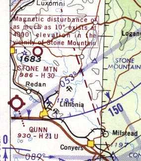
The earliest aeronautical chart depiction of Stone Mountain Airport which has been located was on the 1964 Savannah Sectional Chart (courtesy of John Voss),
which depicted it with a 3,000' hard-surfaced runway.
Doug Rounds recalled, “Stone Mountain Airport... In the mid-1960s I was president of a group that leased the airport from Mark Britt.
There was a 2nd grass/sand runway running along Bermuda Road - you can see where it was by the sand - it began at the south end of the paved runway.
At that time the Stone Mountain golf course was being built & other than that the airport was in the country.
There were a number of Stearmans & a 1929 & 1930s Stinsons based there at the time.”
According to the 1966 “Atlanta Metropolitan Region Comprehensive Plan” (courtesy of David Henderson),
“Low intensity runway lights were programed to be installed in 1965.
These aircraft were reported based at the field in 1965: single-engine, 1-3 places (5); single-engine, 4 or more places (9).”
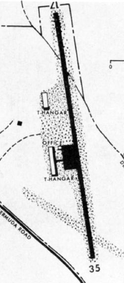
The 1966 “Atlanta Metropolitan Region Comprehensive Plan” (courtesy of David Henderson)
depicted Stone Mountain Airport as having a single Runway 17/35, with an office & T-hangars on the west side.
According to the 1966 “Atlanta Metropolitan Region Comprehensive Plan” (courtesy of David Henderson),
“Access to the field is provided by Bermuda Road, an unpaved rural road leading from a portion of old U.S. Highway 78
(which has been diverted to pass north of Stone Mountain Memorial Park).
The single runway is paved, in good condition (as are the taxiway & apron) & is 2,500' long with a width of 40'; it cannot be extended within existing property limits.
The airport is attended during daylight hours. Aviation fuel is stored in underground tanks with a capacity of 4,000 gallons.
The following facilities & services are also available: Major & minor repairs to power plant, airframe, radio,
Aircraft services: painting, stripping, washing, Aircraft storage: T-hangar 18 spaces, tie-down 50 spaces,
Sales of new & used aircraft, accessories, radios & instruments, Aircraft available for charter – 2, rental – 3, sightseeing – 2,
Flight instruction for all airplane flying ratings: Instructors – 2, Aircraft – 2.”
Travis Britt recalled, “I was raised at the Stone Mountain Britt Memorial Airport (no relation to the name).
My earliest memory of Stone Mountain Airport was as a small child. My father, Benny, was a sky diver & used to jump there.
This would probably have been somewhere around 1967 or 68 that I first remember being at Stone Mountain Airport.
He then restored a PT-19 at Stone Mountain Airport which he completed in 1969.
From that time, I was at the airport almost every day. Stone Mountain Airport is a place that is very dear to my heart.
The reason that it was called Stone Mountain Britt Memorial Airport was to honor the memory of Mamie Britt.
She was the wife of the founder of the airport Mark Britt.”
The 1968 Flight Guide (courtesy of Robert Levittan) depicted Stone Mountain Airport as having a single 2,500' paved Runway 17/35.
A parallel taxiway on the west side of the runway led to a ramp & 2 buildings.
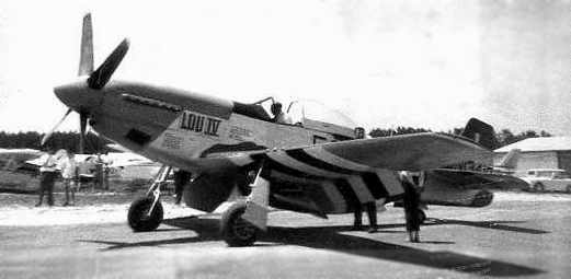
A circa late 1960s photo by Robert Brown of Dave Forrest in his P-51D Mustang passing through Stone Mountain Airport, pictured near the gas pumps.
Dave Forrest recalled, “I also landed there in a FG-1D Corsair.”
According to a 1969 article (courtesy of Robert Brown), a corporation was formed on 4/1/67 to lease Stone Mountain Airport for 20 years with an option to buy.
The purpose of the new operation: “For the enhancement & advancement of tail-draggers.”
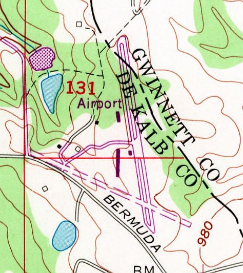
The 1968 USGS topo map depicted Stone Mountain “Airport”
as having a paved NNW/SSE runway with a parallel taxiway, and an unpaved WNW/ESE crosswind runway.
According to a 1969 article (courtesy of Robert Brown), Stone Mountain Airport was described
as having a “narrow, dipping 2,600' hard-surfaced runway faced by a string of high tension wires at one end,
while the world's largest & hardest Omni [Stone Mountain] juts up on one side.”
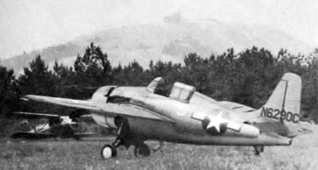
An undated photo from a 1969 article (courtesy of Robert Brown)
showing Mike Rettke's rare flyable FM-2 Wildcat fighter, with Stone Mountain looming in the background.
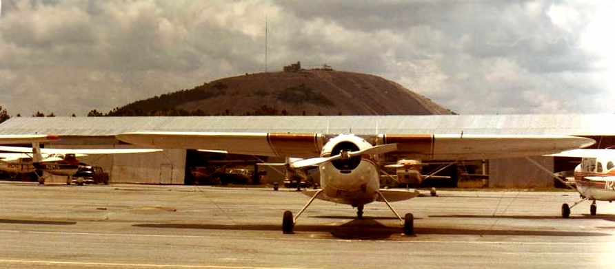
A 1971 photo by Robert Brown of a Cessna 195, N195RE, at Stone Mountain Airport.
Robert remarked, “No prize for guessing how the airport got it's name.”
Edward Shelton recalled, “As early as I can remember, we would go to Stone Mountain & climb to the top.
From there you could see the glider tugs taking off from SMBM so the gliders could float around the mountain for awhile.”
The 1982 AOPA Airport Directory (courtesy of Ed Drury) listed the operator as Stone Mountain Aviation Inc.
According to Travis Britt, airport owner Mark Britt “owned the property until the mid 1980s
when he sold it to a partnership that was trying to save the airport from its eventual demise.
Until this time the airport was always known as Stone Mountain Airport.
Stone Mountain Aviation was the Fixed Base Operator that operated the airport under a lease agreement with Mark.”
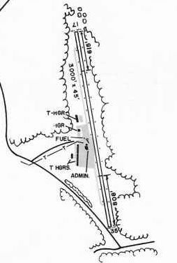
The 1985 GA Airport Directory (courtesy of Charlie Evans) depicted Stone Mountain Airport as having a single 3,000' Runway 17/35,
and an administration building & 3 hangars on the west side.
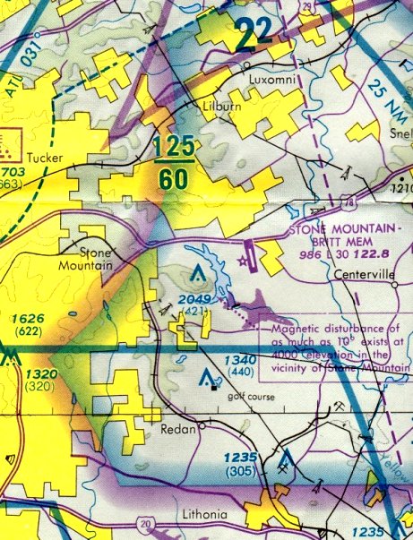
The last aeronautical chart depiction of Stone Mountain Airport which has been located
was on the September 1986 Atlanta Terminal Aeronautical Chart (courtesy of Stu Sibitzky).
It depicted Stone Mountain – Britt Memorial Airport as having a single 3,000' paved northwest/southeast runway.
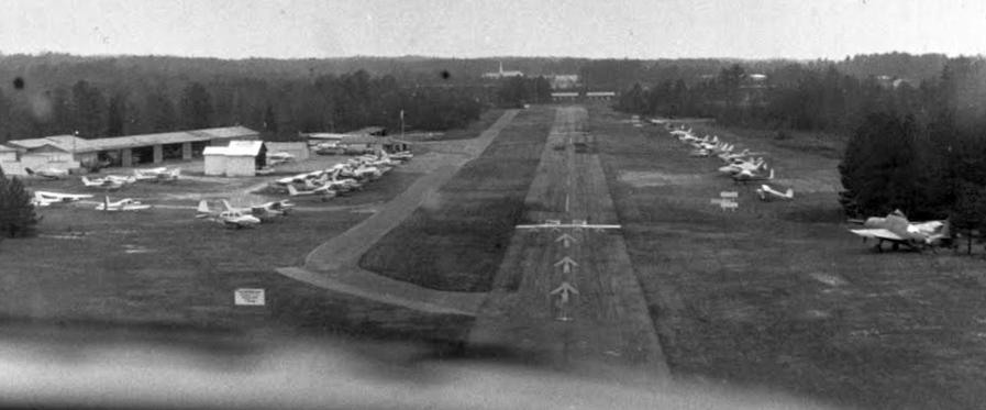
Note the WW2 surplus Grumman TBM-3E Avenger torpedo bomber at far right.
Roy Elks recalled, “Stone Mountain Airport... I first started to hang out at the airfield in mid-1989 & commenced flight training early in 1990 in one of their two 172s (N52741 & N13221).
In March 1991 I based my Piper Archer on the field. I remember with great fondness the pilots based on the field.
There were many true aviators: WW2 pilots, and airline pilots who still found a need to punch through the clouds in their single-engine planes despite choosing flying as a daily occupation.
Along with other private pilots, I learned much from the profuse amount of hangar flying with these very remarkable aviators.
Even during the most adverse winter weather we would sit in front of a crackling wood fire in the old FBO talking about flying.
What marvelous times were had & dear memories remain of Stone Mountain, Brit Memorial Airport.”
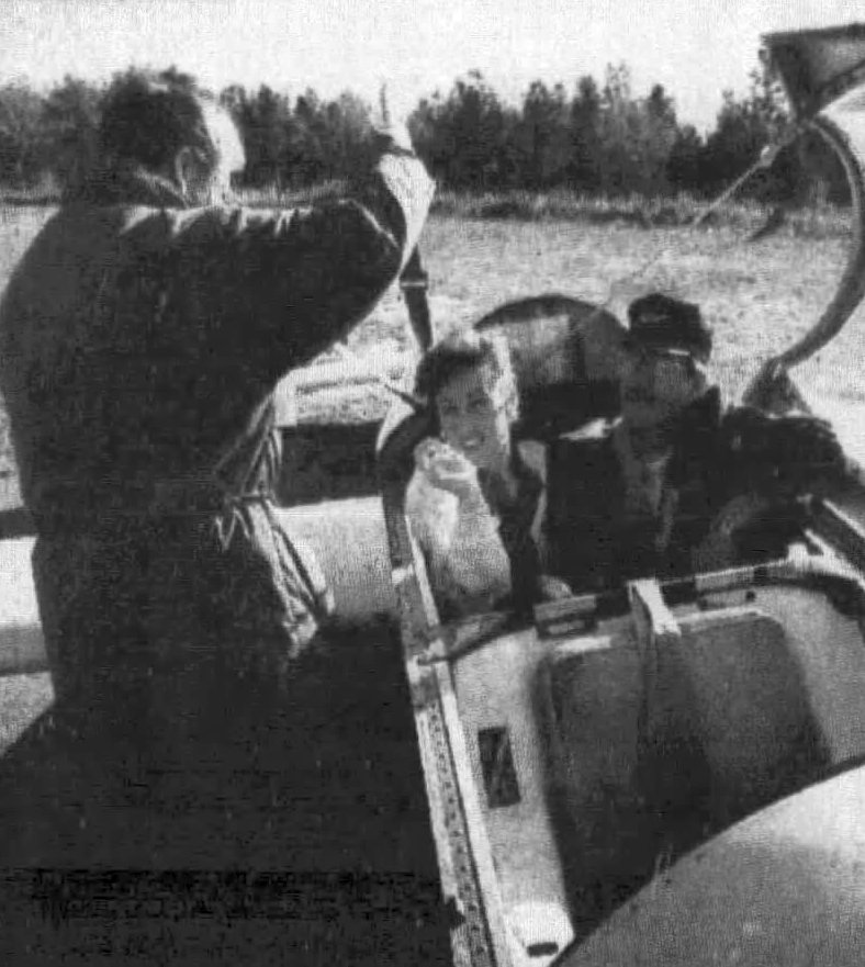
An undated photo from an 11/19/92 article (courtesy of David Henderson) showing glider pilot Ken Sailer loading Kimberly Christianson & Benny Britt for a Schweizer 232 glider flight at Stone Mountain Airport.
Nearby resident David Henderson recalled, “Stone Mountain Airport... Sailplanes were a common sight during the 1990s.
The updrafts created by wind hitting the mountain & the heat rising off of the rock were perfect for sailing.”
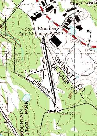
The 1992 USGS topo map depicted Stone Mountain Britt Memorial Airport
as having a runway, parallel taxiway, and several small buildings on the west side.
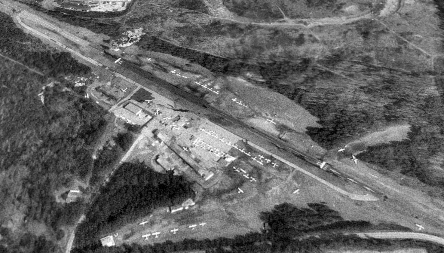
A 1/25/93 USGS aerial view looking northeast at Stone Mountain Airport showed a total of 52 aircraft visible parked outside on the field – obviously a well-used airport.
The field consisted of a single paved 2,700' runway, a crosswind grass runway, taxiways, a ramp & several hangars.
Edward Shelton recalled, “There is a white-roofed building right at the northeast end of the runway.
This is an industrial HVAC equipment manufacturer called Heatcraft.
It was always a little startling to be in their parking lot & seeing a light plane come over the tree line (only barely sometimes) just after takeoff.
The trees masked the sound of the engine until the plane was visible so its arrival was quite a surprise.
The only time I went to the airport itself was the early 1990s. It had fallen out of use, but there were still a few planes there.
In one of the hangars somebody was trying to restore a Dauntless.”
Miranda Skonie recalled of Stone Mountain Airport, “I had my first lesson on New Year's Day 1994, I was 17 years old.
I soloed on 3/26/94. I began working for the FBO in February of that year.
I scheduled the planes, instructors, fueled airplanes, and pretty much whatever needed to be done.
I have very fond memories of the airport & the people that used to hang out there.
I heard so many stories & many of them several times.
I was very sad when the airport did not open back up after the Olympics.
I had hoped to take my kids there someday.”
David Groza recalled, “I started flying back & forth from Stone Mountain Airport in 1994.
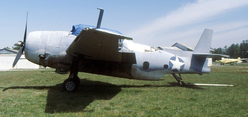
The last photo which has been located showing Stone Mountain Airport still open was a 4/16/95 photo of a WW2 surplus Grumman TBM-3E Avenger torpedo bomber.
David Groza recalled, “I was flying back & forth from Stone Mountain Airport until it closed in 1996 to be turned into a parking lot for the 1996 Olympics!
I remember an old-timer named Bob who I used to hang out with at his hangar, [he] was the last one to leave!
He hated the fact that it was being closed along with all of us who flew out there!
I remember loading up my best friends Cessna 150 & barely clearing the trees on our first cross-country trip to the Oshkosh Air Show!
That was one bumpy short runway & the trees were at both ends which always made for an exciting take off or landing!
My best friend Rob Ketchersid would fly into Stone Mountain Airport every weekend to pick me up so I could fly back with him to his airport.
Then Sunday evening we would fly back & land usually in the dark at the little Stone Mountain Airport.
I remember one night coming in for a landing we used a pair of Russian military-issued night vision binoculars to help us see the runway better.
We even landed there after they had painted a big yellow X on the runway & had already installed light poles all the way down the side of the strip!
We did this to visit our old friend Bob who was the last one to tear down his hangar & move!
We did several low passes to make sure there were no obstacles or anything that would endanger our lives before deciding to land on a closed runway!
That was in 1996 & shortly after that last visit it was turned into a gravel parking lot for the olympics!
We were really sad to see it go & will always remember the fun we had flying in & out of our little airport in the woods next to the giant rock!”
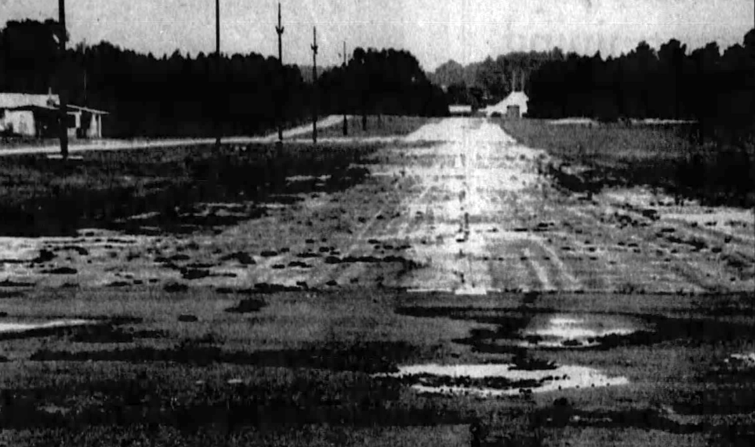
An undated photo from an 8/1/96 article (courtesy of David Henderson) looking along Stone Mountain Airport's Runway 35.
Stone Mountain Airport was closed in 1996, when it was converted into a parking lot
for the tennis & aquatic Olympic events being held at the adjacent Stone Mountain Park.
After the games, the airport owners decided that it would be too costly to reopen the airport,
and the airport site was reused as a parking lot for the Tennis Center.
A 1999 USGS aerial view showed all of the former Stone Mountain Airport buildings had been removed,
although the paved runway & taxiway still remained intact.

A circa 2002-2005 aerial photo looking north at the south end of the former Runway 35,
with the runway markings still visible (although X'd out).
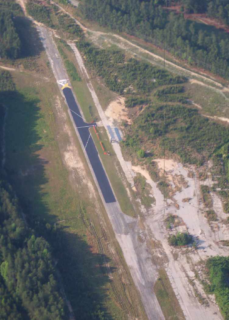
A 2006 aerial view looking south at the south end of the former runway at Stone Mountain, by Graham Watkins.
A small portion of the former runway has been newly repaved,
and a small shelter has been constructed on the former taxiway.
Joerg Wekenborg reported in 2006, “The repaved portion of Stone Mountain Airport's runway
is now home of the Stone Mountain Flyers, a radio-control club flying mostly fixed-wing airplanes.”
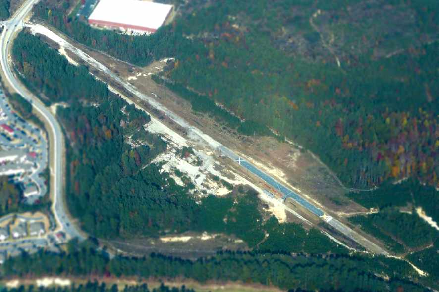
A 2007 aerial view by Robert Morris looking northeast at the remains of the Stone Mountain runway.
A perfectly good general aviation airport, completely going to waste.
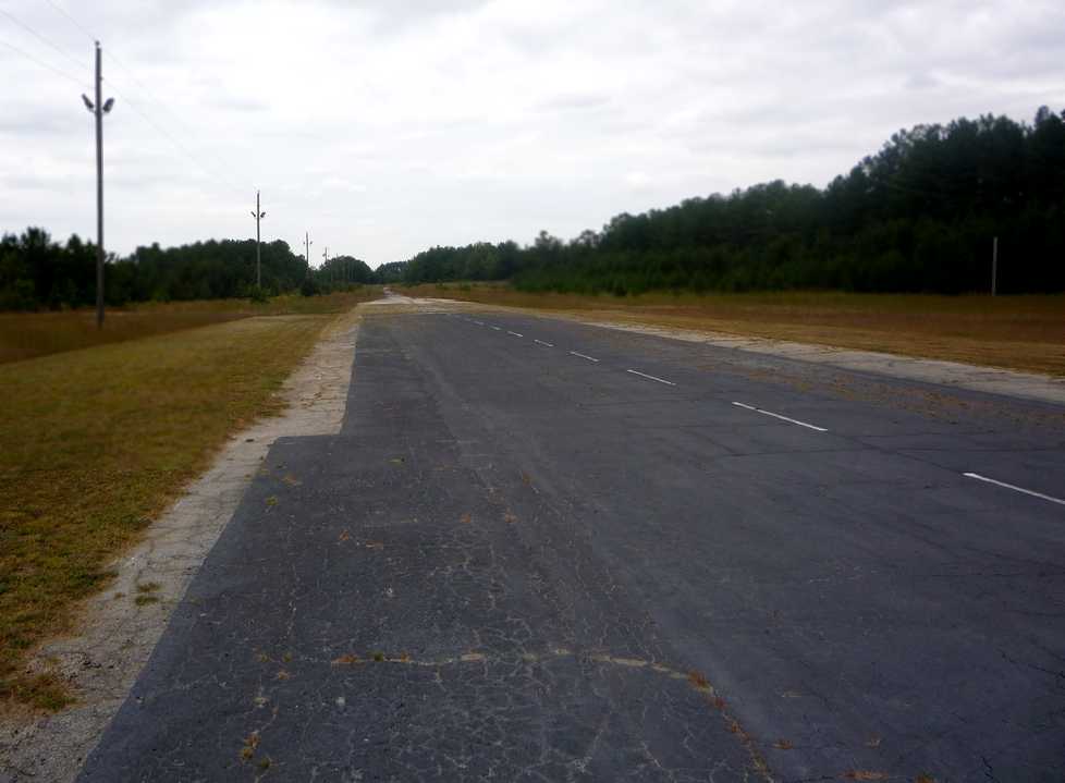
A 2008 photo of the portion of the Stone Mountain runway reused by a model aircraft club.
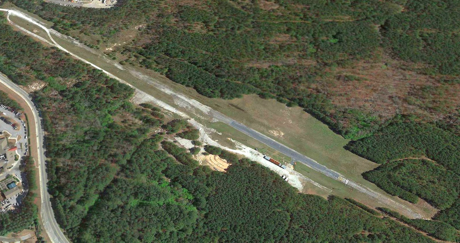
A 2018 aerial view looking northeast showed the site of Stone Mountain Airport remains unredeveloped, with the paved runway intact though deteriorated.
What a shame the property couldn't continue to serve as a grassroots airport.
Thanks to Paulo Santos for information about Stone Mountain.
____________________________________________________
Or if you prefer to contact me directly concerning a contribution (for a mailing address to send a check),
please contact me at: paulandterryfreeman@gmail.com
If you enjoy this web site, please support it with a financial contribution.
____________________________________________________
This site covers airfields in all 50 states.