
Abandoned & Little-Known Airfields:
Arizona: Northwest Phoenix area
© 2002, © 2026 by Paul Freeman. Revised 2/13/26.
This site covers airfields in all 50 states: Click here for the site's main menu.
____________________________________________________
Please consider a financial contribution to support the continued growth & operation of this site.
Coyner Airfield (added 1/10/25) - Fram Field (revised 12/27/22) - Luke Satellite Field #3 / Luke Aux AAF #A1 / Luke Aux AAF #1 / Wittman Field (revised 11/10/23) - Luke Aux AAF #2 / Beardsley Field (revised 12/16/23)
Luke Satellite Field #1 / Luke Aux Field #3 (revised 10/6/21) - Luke Aux AAF #4 (revised 12/1/25) - Pleasant Valley Airport (revised 12/16/23) - Sun City Airfield (revised 11/2/20)
Williams Field / Rex Williams Field / Moseley Field (revised 6/13/23)
____________________________________________________
Coyner Airfield, (AZ60), Litchfield Park, AZ
33.507, -112.475 (Northwest of Phoenix, AZ)
Coyner Airfield, as depicted on a 10/14/77 USGS aerial photo.
This small rural airfield was evidently established at some point between 1971-77,
as it was not yet depicted on a 1971 aerial photo.
The earliest depiction which has been located of Coyner Airfield was on a 10/14/77 USGS aerial photo, which depicted 2 dirt runways.
According to its FAA Airport/Facility Directory data, Coyner Airfield was activated on 12/1/82.
It was a private airfield, having 2 soil runways: 2,800' Runway 5/23 & 1,750' Runway 17/35.

The earliest topo map depiction which has been located of Coyner Airfield was on the 1989 USGS topo map,
which depicted 2 runways, generically labeled as “Landing Strips”.

The earliest photo which has been located showing aircraft at Coyner Airfield was a 1992 USGS aerial view looking northwest.
It depicted 2 dirt runways, with 1 light single-engine plane parked near some small buildings on the east side.

A 3/31/93 photo of Kaman HH-43F Huskie N321WN C/n 25 at Coyner Airfield with an agricultural spray rig.

The earliest aeronautical chart depiction which has been located of Coyner Airfield was on the May 1999 Phoenix Terminal Chart.
It depicted Coyner as a private airfield having a 2,800' unpaved runway.

The last photo which has been located showing Coyner Airfield remaining relatively intact was a 2005 aerial view looking northwest.
Construction to extend Camelback Road had extended across the middle of the north/south runway, cutting its length in half.

A 2011 photo looking southeast at a building remaining on the west side of the Coyner Airfield site.

A 2013 aerial view showed the maximum number of planes seen at Coyner Airfield: a total of 4, including 1 twin-engine aircraft.

The last aeronautical chart depiction which has been located of Coyner Airfield was on the October 2016 Phoenix Terminal Chart.
It depicted Coyner as a private airfield having a 2,800' unpaved runway.

The last photo which has been located showing aircraft at Coyner Airfield was a 2017 aerial view looking northwest.
It depicted 1 light single-engine plane remaining on the field.

A closeup from the 2017 aerial view showing the last aircraft at Coyner Airfield.
Coyner Airfield was evidently closed at some point between 2016-2017, as it was no longer depicted on the 2017 Phoenix Terminal Chart.

A 2021 photo looking southwest at the hangar remaining on the east side of the Coyner Airfield site.

A 2021 photo looking southeast at a truck advertising the reason for Coyner Airfield's demise: The Landings residential development.

A pre2024 photo of the hangar on the east side of the Coyner Airfield site.

A 2024 aerial view looking northwest showed no trace remaining of Coyner Airfield.

A 2024 photo looking southwest at site of the Coyner Airfield hangar.
Thanks to Richard Carlson for pointing out this airfield.
____________________________________________________
Pleasant Valley Airport (P48), Peoria, AZ
33.801, -112.249 (Northwest of Downtown Phoenix, AZ)

Pleasant Valley Airport, as depicted on the 1978 Phoenix Sectional Chart (courtesy of Jonathan Westerling).
Pleasant Valley Airport was not yet depicted on a 1971 aerial photo nor on the June 1977 Phoenix Sectional Chart.
According to its FAA Airport/Facility Directory data, Pleasant Valley Airport was activated in November 1977.
According to the Pleasant Valley Airport website, “Roy Coulliette dreamed of being a pilot after he saw a glider club operating off a dirt highway.
In 1976, Roy moved his Turf Soaring School & began building the Pleasant Valley Airport.”
The earliest depiction which has been located of Pleasant Valley Airport was on the 1978 Phoenix Sectional Chart (courtesy of Jonathan Westerling).
It depicted Pleasant Valley Airport as a private airfield having a 4,000' unpaved runway, and to conduct glider operations.
The June 1981 Phoenix Sectional Chart depicted Pleasant Valley Airport as a private airfield having a 4,000' unpaved runway, and to conduct glider operations.
The earliest photo which has been located of Pleasant Valley Airport was a 1981 aerial view.
It depicted Pleasant Valley Airport as having 3 unpaved runways: 2 parallel northeast/southwest & 1 northwest/southeast.

The earliest topo map depiction which has been located of Pleasant Valley Airport was on the 1981 USGS topo map.
It depicted a generically labeled “Landing Area” as having 3 unpaved runways: 2 parallel northeast/southwest & 1 northwest/southeast,
with a ramp & 2 small buildings on the southeast side.
Duncan Woods recalled, “Pleasant Valley Airport was the home of Turf Soaring School.
It was mostly used for sailplanes, although there were some ultralights there also.
Back in the 1980s, I went there for several ultralight events.
I remember it was still called Turf Soaring School after the move, but I’d never heard the name Pleasant Valley Airport.
They probably changed to that name later on sometime after all the ultralight events.
There always seemed to be a lot of flying going on there; sometimes we’d stop & watch the gliders being towed up or coming back in to land.
Didn’t see many ultralights, though; after the initial flurry of interest died down, fewer ultralights used the field,
although I understand that EAA ultralights Chapter 55 held its monthly meetings at the field.”
A 1985 aerial view still depicted Pleasant Valley Airport as having 3 unpaved runways.
A 1988 aerial view showed Pleasant Valley Airport had gained a 3rd parallel runway, bringing its total to 4 runways.

The earliest photo which is available of Pleasant Valley Airport was a 1997 USGS aerial view.
It depicted Pleasant Valley as having 4 unpaved runways, with a large number of gliders & other small aircraft on the north & south sides.
According to the Pleasant Valley Airport website, “By the year 2000, the Turf Soaring School was recognized as one of the major soaring schools in the country
with 11 gliders, 4 tow planes, and operated over 12,00 flights per year.
Pleasant Valley Airport is also home to Civil Air Patrol Cadet Training Squadron Flight 400, the most active in the US.”

The May 1999 Phoenix Terminal Chart depicted Pleasant Valley Airport as a private airfield having a 4,000' unpaved runway, and to conduct glider operations.
According to its FAA Airport/Facility Directory data, Pleasant Valley Airport had an average of 205 takeoffs or landings per day for the year ending 4/24/08.
It had 14 single-engine aircraft based on the field & 5 ultralights.
The owner was listed as Pleasant Valley Airport Association, and the manager as Rick Brown.
It was described as having 3 parallel dirt/gravel Runways 5/23 L/C/R, and a 2,400' gravel Runway 14/32.
Gary Vacin recalled in 2022, “I landed at the Pleasant Valley Airport 10 years ago”, [circa 2012].

A 2017 aerial view depicted Pleasant Valley Airport as having a healthy number gliders & other small aircraft on its ramp.

The 2021 Phoenix Terminal Chart depicted Pleasant Valley Airport as a public-use airport having a 4,200' unpaved runway, and to conduct glider operations.
Jon Radowski recalled, “I learned to fly gliders & airplanes & soloed both types here at Pleasant Valley Airport.
I have occasionally landed my hot air balloons on the property over the years.”

A 2021 photo looking north at Pleasant Valley Airport hangars, windsock, and airport office.

A 12/20/21 aerial view by Jon Radowski of Apex Balloons looking down from his balloon at Pleasant Valley Airport.

A 12/20/21 aerial view by Jon Radowski of Apex Balloons looking northwest at Pleasant Valley Airport.

A 12/20/21 aerial view by Jon Radowski of Apex Balloons looking south at the hangars & buildings of Pleasant Valley Airport.
Unfortunately, Jon Radowski reported in 2022, “Pleasant Valley Airport has closed operations as of this fall/winter (possibly end of October).
It has been removed from sectional charts & GPS databases & there are large X's made from tires closing all 4 runways.
The land the airport was built on was leased from the AZ State Land Department for many years.
However, the lease was recently not renewed & the current tenants must vacate the property by February 2022.
Most of the hangars on the north side of the field have been disassembled &/or removed already, as well as the RV park on the south side of the property.
I'm quite sad to see it closed.”

A 2021 aerial view depicted Pleasant Valley Airport devoid of aircraft, presumably after its closure.

A 2023 photo looking southwest along Pleasant Valley Airport's former Runway 23.
Thanks to Jon Radowski for pointing out this airfield.
____________________________________________________
Williams Field / Rex Williams Field / Moseley Field, Glendale, AZ
33.502, -112.252 (Northwest of Downtown Phoenix, AZ)

Williams Field, as depicted on the September 1948 Phoenix Sectional Chart.
This little general aviation airport on the west side of Phoenix was evidently established at some point in 1948,
as it was not yet depicted on the March 1948 Phoenix Sectional Chart.
The earliest depiction which has been located of Williams Field was on the September 1948 Phoenix Sectional Chart.
It depicted Williams Field as having a 2,600' unpaved runway.

Williams Airport was depicted as a rectangular property outline on a 1952 street map.
Williams Field was still depicted on the March 1952 Phoenix Sectional Chart.
Williams Field was evidently closed (for reasons unknown) at some point in 1952,
as it was no longer depicted on the September 1952 Phoenix Sectional Chart.
The earliest photo which has been located of Williams Field was a 1953 aerial view.
It depicted Williams Field to have a single east/west runway, with a hangar at the southwest end, and 1 light single engine aircraft.
Williams Field was not depicted on Phoenix Sectionals from 1955/57.

The 1957 USGS topo map depicted Williams Field as having a single paved east/west runway, with 2 small buildings on the west end.

A 1960 photo of Chance-Vought F4U-4 Corsair BuNo 97359 while in storage with Bob Bean at Williams Field / Moseley Field.
This mighty fighter eventually spent 19 years deteriorating outside after being purchased by Bob Bean in November 1957.
Williams Field was not depicted on 1960/61 Phoenix Sectional Charts.

Williams Field was evidently reopened as the Rex Williams private airfield at some point between 1961-65,
as that is how it was labeled on the January 1965 Phoenix Sectional Chart.
It depicted Rex Williams Field as having a 2,500' unpaved runway.
Rex Williams Field was evidently closed (for reasons unknown) at some point in 1965,
as it was no longer depicted on the July 1965 – January 1966 Phoenix Sectional Charts.

Rex Williams Field was evidently reopened as Moseley Field at some point in 1966,
as that is how it was labeled on the July 1966 Phoenix Sectional Chart.
It depicted Moseley Field as a public-use airport having a 2,600' unpaved runway.

The 1966 Phoenix Local Aeronautical Chart depicted Moseley Field as having a 2,500' unpaved runway.

An undated aerial view of Moseley Field (courtesy of Matt Gunsch) showed the field to have a single east/west runway, with a hangar at the southwest end, and a dozen aircraft.
Matt Gunsch recalled, “I live about a mile from where Mosely Field was; it was located on the northeast corner of 91st Avenue & Campbell Road.
Some of the planes on the field are the Mosely Field Corsairs; Bob Bean stored them there after flying them out of Litchfield NAS.”

A May 1970 photo by Hank Rappone of Chance-Vought F4U-4 Corsair BuNo 97359 while in storage with Bob Bean at Moseley Field.
A 1970 aerial view depicted Williams Field at perhaps its zenith of usage, with over 20 aircraft visible on the field.

An August 1971 photo by Jay Sherlock of Navy Chance-Vought F4U-4 Corsair BuNo 97142 (originally from NAS Seattle) at Moseley Field.

An August 1971 photo by Jay Sherlock of Navy Chance-Vought F4U-4 Corsair BuNo 97390 (originally from NAS Olathe) at Moseley Field.

A 1971 USGS aerial photo depicted Williams Field as having a single paved east/west runway, with some small buildings on the west end.

The last aeronautical chart depiction which has been located of Moseley Field was on the June 1972 Phoenix Sectional Chart.
It depicted Moseley Field as a private airfield having a 2,600' unpaved runway.
The last photo which has been located showing aircraft at Moseley Field was a 1973 aerial view, which depicted 4 aircraft on the field.
Moseley Field was evidently closed (for reasons unknown) at some point between 1972-74,
as it was no longer depicted on the 1974 USGS topo map.
A 1974 aerial view showed the Moseley Field runway & hangar remained intact, but the field was devoid of aircraft.
A 1975 aerial view showed the Moseley Field hangar had been removed.
Tom Friedkin purchased the F4U-4 Corsair BuNo 97359 at Moseley Field on 11/19/75; it would eventually be restored & would be featured in the Black Sheep Squadron TV series.
Moseley Field was no longer depicted on the 1977 Phoenix Sectional Chart.
A 1977 aerial view showed Juan Bautista de Anza High School had been constructed over the west side of the Moseley Field property,
erasing the last trace of the little airport.

A 2019 aerial view looking northeast showed no trace remaining of Moseley Field.
Thanks to Matt Gunsch for pointing out this airfield.
____________________________________________________
Sun City Airfield, Sun City, AZ
33.74, -112.26 (Northwest of Phoenix, AZ)

A 2/14/49 aerial view (from the Maricopa County Flood Control District) depicted the airfield as having a single unpaved northeast/southwest runway.
Photo of the airfield while in use has not been located.
This field may have been established during WW2 as a satellite airfield
used to support flight training operations at nearby Thunderbird Field.
The date of this airfield's construction has not been determined, nor any details of its use.
No airfield was depicted at this location on the March 1946 Phoenix Sectional Chart.
The earliest depiction of this field which has been located was a 2/14/49 aerial view (from the Maricopa County Flood Control District).
It depicted the airfield as having a single unpaved northeast/southwest runway,
along with a possible graded aircraft parking area on the southern side.
It is not known if the field was every reused for military or civil flying after the war, but it appears unlikely.

The 1981 USGS topo map labeled the "Landing Strip" as consisting of a single 2,800' runway,
running parallel along the east side of North Lake Pleasant Road.

A 1997 USGS aerial view looking northwest showed the Sun City runway was still barely perceptible on the desert floor, if you know where to look.

A 2019 aerial view looking northwest showed houses had been built over the Sun City airfield site, with portions of the runway still barely recognizable at bottom-left & top-right.
The Sun City airfield is located northeast of the intersection of North Lake Pleasant Road & West Pinnacle Vista Road.
____________________________________________________
33.53, -112.28 (Northwest of Phoenix, AZ)

Fram Field, as depicted on the September 1941 Phoenix Sectional Chart (courtesy of Chris Kennedy).
According to Donalyn Fram Easterday, his grandfather Ray Fram "known as Pops to us, was a special person.
Ray fell in love with flying as a doughboy in France fighting in the trenches.
So after the War [WW1] he returned, married & started learning to fly.
His instructor was Bill Landon & he learned in an Eagle Rock, American Eagle, old engine OX5, water cooled.
He really liked his instructor. His instructor did not carry a club as some did in those days.
The instructor, Bill, was in the front seat & a student in the back.
The student froze holding the stick back keeping the plane in a spin.
If he had had a bat, he could have turned & knocked the student out. So those 2 spun in."
Donalyn continued, "Ray went to South Central Airport, [where] Goldtrap & Lee had a flying service.
They had 3 Monopreps (2-place) & one Monocoup (faster than the Monoprep).
He flew with them & bought one NC111K built in 1928. It had the name painted on it, 'The Spirit of the Depression'.
The inspector did not like it & said paint it out, so he did."
Donalyn continued, "It was a fabric plane, so friends came & moved the chicken pens together to shade the plane.
With Ray's $600 bonus from the War, he hired a Mexican contractor.
Times were tough; labor was 15 cents / hour. Adobe bricks were $25 / 1,000.
Part went to make their house & part of the brick made the hangar.
Ray became a popular instructor pilot on weekends as he had to farm during the week.
Dad said Fram Field was busier on weekends than Sky Harbor was."
Donalyn continued, "Ray's daughter Kay got her pilot's license at 16, and my son, my Dad, would fly to football practice at Peoria
as he had to get the chores done & they only owned a milk truck."
Ray also bought a Portierfield Zepher, a 3570 Portierfield #16498, and a 384H Fairchild KR-34.
Fram Field was not yet depicted on the January 1941 Phoenix Sectional Chart.
The earliest depiction of Fram Field which has been located
was on the September 1941 Phoenix Sectional Chart (courtesy of Chris Kennedy).
Fram Field was still depicted on the February 1943 Phoenix Sectional Chart (courtesy of Chris Kennedy).
Donalyn Fram Easterday said "The government closed the airport during WWII & locked the planes in the hangar.”
Fram Field was not depicted on the March 1945 Phoenix Sectional Chart (courtesy of Ron Plante).
Donalyn Fram Easterday recalled, “After the war [WW2] Ray resumed instructing.”
A directory of AZ Airports in the 5/47 issue of Arizona Highways (courtesy of George Miller),
described Fram Field as having a 2,100' runway.

The earliest photo which has been located of Fram Field was a 2/14/49 aerial view (from the Maricopa County Flood Control District).
It depicted the field as having a single unpaved east/west runway, with a small hangar & 2 small aircraft on the east side of the field.
Brenda Shears recalled, “I am Max Shears' daughter. My father ran his crop dusting business [at Fram Field].
Three of my brothers became cropdusters. I hung around the airport a lot when I was young in the 1950s.”
An article entitled “Duster Heaven” by Harry Gann (courtesy of Brian Baker) in a circa 1957-58 AAHS Journal
said “On 99th Avenue & Glendale Avenue is Fram Field.
Max Shears & Bill Mason have a collection of airplanes that would whet the appetite of any aviation enthusiast.
The December 1957 issue of American Airman had an interesting article about the field.
I have photographed the following Standards there: Jones New Standard D-25 duster, N19155, Wright R-975-11.
New Standard D-25 sprayer, N9194, Lycoming R-690-9. New Standard D-25 duster, N31K, Wright R-975-11.”
Dave Stevenson recalled, “Fram Field... Max Shears was a well-known cropduster.
He had an old adobe hangar, and 5 New Standard D-25s.”

The earliest ground-level photo which has been located of Fram Field was a circa 1950s photo by Brian Baker of a New Standard biplane, with an unusually large exhaust stack.
Brian recalled, “It was parked on the south side of the strip. I only saw 2 of them there, although Gann lists another.”
The number of aircraft visible on Fram Field increased to 8 in a 2/20/59 aerial view (from the Maricopa County Flood Control District).

A circa 1961-64 photo by Jim Lindsay of the BC-12D Taylorcraft, N96020 he co-owned with Donald Lester, at Fram Field, with 2 of Max Shear's cropdusters in the background (courtesy of Fred Lester).
Fred recalled, “Dad parked it at Fram Field. The far cropduster is N19155. My dad learned to fly in 1960. His instructor was Max Shears.
I have more memories of the things in the hangar: an engine laying around the hangar, with crates of new engines, government surplus.
He would change out an engine & put another one in. I know of only 3 planes; one was in the hangar rafters.”
In the 1962 AOPA Airport Directory, the operator of Fram Field was listed as M. B. Shears.
Donalyn Fram Easterday said "The man you have listed as running the airport either sold or gave away the planes.
None of the family was living in the Phoenix area at that time to keep tabs on what was happening."

A 1964 street map (courtesy of Kevin Waslh) depicted Fram Field as having a single east/west runway, with “Limited facilities”.
Michael Grantland recalled, "My grandfather, Richard Comfort,
lived on & operated this air field from the mid 1960s through the 1980s until it was closed down.
My Grandparents lived there for over 30 years while it was Fram Field Aviation.
My Grandfather said he leased the property from Mrs. Fram."
Daniel Gilsdorf recalled, “I spent many years growing up, following Dick Comfort at Fram Field in the late 1960s into the 1970s.
I want to say his wife's name was Trudy, and I think he had a son Wayne. She had a Stanley Steamer and an old J3 Cub stored in the back of the old hangar.
Max Shers' Sanders were parked down the runway to the west. Old Dick was a member of the Sheriff's airport.”

A closeup from a 1970 aerial view, showing Fram Field at its peak of popularity,
with a total of 15 single-engine aircraft parked around a few small buildings on the southeast side of the field.

The January 1971 Phoenix Sectional Chart closeup portion (courtesy of Ron Plante)
depicted Fram Field as having a 2,200' unpaved runway.
The December 1976 Phoenix Sectional Chart (courtesy of Chris Kennedy)
depicted Fram Field as having a 2,200' unpaved runway.

The 1977 Phoenix Sectional Chart close-up portion (courtesy of Ron Plante) depicted Fram Field as having a 2,200' unpaved runway.

The last photo which has been located of Fram Field was a 12/15/79 aerial view (from the Maricopa County Flood Control District).
A dozen small general aviation aircraft were visible parked at the southeast end of the field.

The last aeronautical chart depiction which has been located of Fram Field was on the June 1981 Phoenix Sectional Chart (courtesy of Paul Sibitzky).
It depicted Fram Field as a private airfield having a 2,200' unpaved runway.
In the 1982 AOPA Airport Directory (courtesy of Ed Drury), Fram Field was described as having a single 2,160' dirt Runway 8/26,
and the operator was listed as Fram Field Aviation.
The Notes said, "Private. Use at own risk. Field closed to all students. W end of field may be flooded."

The 1982 USGS topo map depicted Fram Field as having a single 2,600' runway, oriented east/west.
According to Michael Grantland (grandson of Fram Field operator Richard Comfort), "It was closed down in 1984."
Fram Field was no longer depicted on the November 1985 Phoenix Sectional Chart (courtesy of John Voss).
Fram Field was still depicted on the 1988 USGS topo map, but was labeled simply "Landing Strip".

A 1992 USGS aerial view looking northwest showed Fram Field was still intact several years after it had been closed, including the runway & the hangar on the east side.
Fram Field was no longer depicted at all (even as an abandoned airfield) on the 1998 Sectional Chart.
Donalyn Fram Easterday said "Even though the field doesn't exist [anymore],
the property is still in the family & it was a part of aviation history in the area."

An 11/6/13 photo by Chris Kennedy looking west at what appears to be a Fram Field foundation, southwest of the intersection of 99th Avenue & Maryland Avenue.

A 2016 aerial view looking northwest at the site of Fram Field shows no trace remaining of the runway, with the land having reverted to farming.
The last remaining trace of the little airfield is the foundation of the hangar on the east side (bottom-right).
The site of Fram Field is located northwest of the intersection of North 99th Avenue & West Rose Lane,
a half mile east of the present-day Glendale Municipal Airport.
____________________________________________________
Luke Satellite Field #3 / Luke Auxiliary Army Airfield #A1 / Luke Auxiliary Army Airfield #1 / Wittman Field, Glendale, AZ
33.72, -112.53 (Northwest of Luke AFB, AZ)

The earliest photo which has been located of Luke “Satellite Field #3” was an 8/29/42 USAAF aerial view (courtesy of Brian Rehwinkel).
This satellite airfield for Luke Army Airfield confusingly went through an early name resignation,
being first known as Luke Satellite Field #3, then as Luke Auxiliary Field #1.
Luke Satellite Field #3 was built during WW2 as one of a large number of satellite airfields for Luke AAF,
which was the largest single-engine advanced training base in the world during WW2.
According to the "History of Luke AFB" (obtained by David Brooks from the public affairs office at Luke AFB),
"The first [of Luke's auxiliary airfields], appropriately named Auxiliary Field #1, but also known as Wittman,
served as the training site for P-40 operations when Luke Field became too congested with aircraft.
Wittman Field was located 4.5 miles south of the Arizona town with the same name & was activated on 7/1/41."
The configuration of Wittman Field was described as "having 4 runways, three being 300' wide & 4,000' long & built in an equilateral triangle configuration,
with a 300' x 3,600' landing strip bisecting the center.
The 4-runway configuration… cost $300,000 to construct.
Wittman Field facilities were limited to a control tower, crash truck shed & a generator shed. Wittman totaled 709 acres."
The earliest photo which has been located of “Luke Satellite Field #3” was an 8/29/42 USAAF aerial view (courtesy of Brian Rehwinkel).
It depicted the field as having 4 paved runways, with a cluster of small buildings or tents to the northwest.
The east/west runway had the field elevation of “1531” painted in the middle, and the field designation “3” was painted inside a large circle on the eastern end.
By the time of a 12/2/42 USAAF aerial view (courtesy of Brian Rehwinkel), it was captioned as “Aux. Field #A1”.
The physical airfield configuration was unchanged, including the airfield designation of “3” inside a large circle on the eastern end.
Closed-runway “X” symbols were painted on the west & northeast runway ends.
Wittman Field was not yet depicted on the March 1944 Phoenix Sectional Chart.

A 6/7/44 aerial view looking northeast from the 1945 AAF Airport Directory depicted Wittman as having 4 paved runways.

The earliest aeronautical chart depiction of the Wittman auxiliary field which has been located was on the March 1945 Phoenix Sectional Chart (courtesy of Chris Kennedy).
It depicted Wittman "#1" as an auxiliary airfield.
The 1945 AAF Airfield Directory (courtesy of Scott Murdock) described Luke Field Auxiliary #1 (Wittman Field)”
as a 709 acre square property within which were 4 bituminous runways,
with the longest being the 4,000' northeast/southwest, WNW/ESE, and NNW/SSE strips.
The field was described as not having any hangars, and to be operated by the Army Air Force.
According to the "History of Luke AFB" (obtained by David Brooks from the public affairs office at Luke AFB),
"It remained a Luke Field asset through the base’s inactivation in 1946."

The 1947 Gila River World Aeronautical Chart depicted Luke AF #1 as having a 3,900' paved runway.
Luke Aux AAF #1 was listed in a directory of AZ Airports in the 5/47 issue of Arizona Highways (courtesy of George Miller),
which described the field as being unattended, and the longest runway as being 4,000'.

Luke Aux #1 evidently gained a much lengthened northwest/southeast runway at some point between 1947-53 (presumably to support jet aircraft),
as depicted on a 3/31/53 USGS aerial view.
Bob McCutchen reported, “As an oral history from my Dad (Robert McCutchen Sr., a 1950s Thunderbird pilot), the Luke Auxiliary #1 (Wittman Field) was used as the practice field for the early Thunderbirds who flew out of Luke from 1953-56.
Since Luke was a busy field the 3600th Aerial Demonstration Team (the Thunderbirds) used Auxiliary #1 to practice their airshows.”
"Luke AF #1" was still depicted as an active airfield on the 1956 Phoenix Sectional chart (courtesy of John Voss), and described as having an 8,800' runway.
This airfield was apparently one of the last of Luke's many surrounding WW2-era satellite airfields to remain open.
Unlike most of the others, it was still depicted as an active airfield on the 1966 Phoenix Local aeronautical chart (courtesy of John Voss).
The December 1976 Phoenix Sectional Chart (courtesy of Chris Kennedy) depicted Luke AF #1as having 4 paved runways, with the longest being 7,800'.
The Volvo Arizona Proving Ground (automobile test track) was constructed adjacent to the southeast corner of the airfield, opening in 1985.

"Luke AF #1" was still depicted as an active airfield on the 1988 Phoenix Sectional Chart (courtesy of Jonathan Westerling).
It was depicted as having 4 paved runways, with the longest being 7,800'.
Luke Auxiliary #1 was evidently closed at some point between 1988-93, as it was labeled “Closed” on the May 1993 Phoenix Sectional Chart (courtesy of Ron Plante).
Luke Auxiliary #1 had yellow Xs painted along the length of Runway 11/29 on a 1993 aerial view, but it also appeared to have relatively-recent runway markings.

A remarkable composite picture, in which David Brooks has superimposed close-up views of the numerous former Luke auxiliary airfields over the 1996 USGS aerial photo, showing their location relative to Luke AAF/AFB.

A 1997 USGS aerial view looking northeast at Luke Aux #1 showed the upper 3 runways were laid out in the triangular arrangement typical of a WW2 Army Airfield, while the primary runway was eventually further lengthened to 10,000'.
Although officially not an active military airfield, new navigational radio & radar equipment has been installed by the USAF at the Wittman airfield in recent years.
This is a fairly unusual case of an abandoned airfield being reused for practice approaches (which are not continued all the way toward a landing).
Ironically, there are plenty of active airfields which do not have any instrument approaches at all,
while this abandoned airfield has an elaborate set of ground-based instrument approach aids!
According to Lt. Col. Mark Scharf (F-16 ANG pilot, and former F-16 IP at Luke AFB),
"The students at Luke AFB, learning in the initial phases of F-16 training, have to do a number of instrument approaches before their "qualification" checkride.
To relieve some congestion at Luke AFB proper, Aux 1 was equipped with a Precision Approach Radar (PAR) and a localizer/ILS to the abandoned runway.
All approaches are to Runway 11 (from the Northwest). I don't know when this was done, but it's been operating for quite a while.
F-16s departing the MOAs to the northwest of Luke can easily drop into Aux 1 for practice approaches, then continue back to Luke, which is just over the White Tank Mountains.
The runway is not suitable for landing (big warning on the approach plates we use) because of the breakdown & foliage growth."

A 2002 photo by a local AZ pilot of the localizer antenna at Wittman Aux.
He observed, "There are fresh yellow 'X's on the runway, and 2 white 'T's painted about where the runway thresholds should be."

A 2002 photo by a local AZ pilot of a glideslope antenna at the end of Runway 29 at Wittman Aux.

An August 2005 aerial view by Alejandro Diaz looking west at the Wittman airfield, with the facilities of Ford's Volvo Arizona Proving Ground visible at the bottom-left.

A 3/10/19 aerial view by Tim Gagnon looking east at the remains of Luke Aux #1.

An 11/24/22 photo by Kurt Bob looking along the remains of the Luke Auxiliary #1 /Wittman Field main runway, “ery overgrown with small desert shrubs”, but with the runway numbers still visible.

An 11/24/22 photo by Kurt Bob at the site of Luke Auxiliary #1 /Wittman Field.
Kurt observed, “Added during the very end of the field's useful life, the electronics building & tower, 1 mile down Runway 11, is virtually the only structure left on the entire airfield.”
____________________________________________________
Luke Auxiliary Army Airfield #2 / Beardsley Field, Glendale, AZ
33.704, -112.42 (Northwest of Luke AFB, AZ)

An 8/29/42 USAAC aerial view of Beardsley Field (from the National Archives, courtesy of Brian Rehwinkel).
Beardsley Field was built during WW2 as one of a large number of satellite airfields for Luke AAF,
which was the largest single-engine advanced training base in the world during WW2.
According to the "History of Luke AFB" (obtained by David Brooks from the public affairs office at Luke AFB),
"The origination date of [Beardsley Field] is lost to history."
The site consisted of 580 acres that were leased by DoD, presumably at some point after Luke Air Force Auxiliary Field #1, which was acquired in 1942.
The configuration of Beardsley Field was described as "having 4 runways, three being 300' wide & 4,000' long & built in an equilateral triangle configuration,
with a 300' x 3,600' foot landing strip bisecting the center.
The 4-runway configuration… cost $300,000 to construct.
Beardsley Field facilities were limited to a control tower, crash truck shed & a generator shed."
Beardsley also had a 4,000 gallon water tank & a wind tetrahedron.
The earliest photo which has been located of Bearsley Field was an 8/29/42 USAAC aerial view (from the National Archives, courtesy of Brian Rehwinkel).
It depicted Beardsley as having 4 paved runways.

A 6/17/43 aerial view looking east from the 1945 AAF Airport Directory depicted Beardsley as having 4 paved runways.
Beardsley Field was not yet depicted on the March 1944 Phoenix Sectional Chart.

The earliest aeronautical chart depiction of the Beardsley airfield which has been located was on the March 1945 Phoenix Sectional Chart (courtesy of Chris Kennedy).
It depicted Beardsley "#2" as an auxiliary airfield.
The 1945 AAF Airfield Directory (courtesy of Scott Murdock) described Luke Field Auxiliary #2 (Beardsley Field)”
as a 587 acre square property within which were 4 bituminous runways,
with the longest being the 4,000' ENE/WSW, WNW/ESE, and NNW/SSE strips.
The field was described as not having any hangars, and to be operated by the Army Air Force.
According to the "History of Luke AFB" (obtained by David Brooks from the public affairs office at Luke AFB),
"It remained a Luke Field asset through the base’s inactivation in 1946."
The 1947 Gila River World Aeronautical Chart depicted Luke AF #2 as having a 3,900' paved runway.

A 2/14/49 aerial view (from the Maricopa County Flood Control District) depicted Beardsley as having 4 paved runways.
"Luke AF #2" was depicted as an active airfield on the 1956 Phoenix Sectional chart (courtesy of John Voss),
which described the longest runway as being a 3,800' hard-surfaced strip.
According to an Army Corps of Engineers report, after the Air Force completed use of the property, it was sold to a private owner.
The north/south runway was used for drag racing at some time in the past.
Owen Gibson reported “I have movie footage of a race at Beardsley...
the site was listed as 2.5M N/W of Beardsley on Hwy 60/70/89.
This was November 1958 & the track design was listed as 3,400' straights & has that classic triangle look.”
"Luke AF #2" was labeled "Closed" on the 1964 Phoenix Sectional Chart (according to Chris Kennedy).

"Luke AF Aux #2" was depicted as a closed airfield on the August 1971 USAF Tactical Pilotage Chart (courtesy of Chris Kennedy).

A 1997 USGS aerial view looking north showed all 4 Beardsley Field runways remained intact.
According to a 1998 Army Corps of Engineers report, all facilities (except for the runways) have been removed from the site.
The current owner leases the property to a rancher for cattle grazing.

As seen in a 2005 aerial photo looking northeast by Jim Baker of Hikari Photography,
the runways of Luke Aux #2 appear to remain in the same condition as depicted in 1997.

An April 2007 aerial view by John Galban looking southwest at the site of Beardsley Aux #2,
showing that over half of the airfield has been removed for new construction.
John reported, “I was taken by surprise when flying from Phoenix to Kingman last spring & noticed that this old landmark had almost disappeared.”

A November 2009 photo by Chris Kennedy looking north along part of the north/south runway of Luke Auxiliary #2.
Chris observed, “Access is less than ideal. Only a little less than half of this runway is left & this is taken looking north from the south end of the remaining portion.
It's not really recognizable as a runway from this angle, just an area where the bushes are a little smaller.
Ironically, the housing development that was the reason that most of the field was plowed up is mostly just empty streets, as are many of the other ones around here.”

A 2019 aerial view looking north showed much of the site of 4 Beardsley Field had been redeveloped, with only portions of 2 runways remaining on the north side of the site.
____________________________________________________
Luke Satellite Field #1 / Luke Air Force Aux #3, Glendale, AZ
33.631, -112.365 (North of Luke AFB, AZ)

The earliest photo which has been located of Luke “Satellite Field #1” was an 8/29/42 USAAF aerial view (courtesy of Brian Rehwinkel).
This satellite airfield for Luke Army Airfield confusingly went through an early name resignation,
being first known as Luke Satellite Field #1, then as Luke Auxiliary Field #3.
Luke Satellite Field #1 was built during WW2 as one of a large number of satellite airfields for Luke AAF,
which was the largest single-engine advanced training base in the world during WW2.
Luke Satellite Field #1 was evidently built after 1941,
as it was not yet depicted on the September 1941 Phoenix Sectional Chart (courtesy of Chris Kennedy).
According to an Army Corps of Engineers Report, the 656 acre property for Luke Aux #3 was originally acquired in 1942.
According to the "History of Luke AFB" (obtained by David Brooks from the public affairs office at Luke AFB),
"Auxiliary Field Number 3 was simply referred to as Fighter Field.
It was located 12.5 miles west-northwest of Glendale & became a Luke Field asset on 12/1/42."
The airfield configuration of Field #3 was described as "having 4 runways,
three being 300' wide & 4,000' long & built in an equilateral triangle configuration, with a 300' x 3,600' landing strip bisecting the center.
The 4-runway configuration… cost $300,000 to construct.
[Among Luke's auxiliary airfields], Fighter & Goodyear Fields boasted the most facilities,
each having separate buildings for crew chiefs, operations, supply, barracks, pit latrine, crash truck shed, generator shed & a control tower.
Building construction cost totaled $24,500.
Adding the $11,400 cost for the land, Fighter Field at $335,900 was the most expensive purely auxiliary field owned by Luke during the era."
The earliest photo which has been located of Luke “Satellite Field #1” was an 8/29/42 USAAF aerial view (courtesy of Brian Rehwinkel).
It depicted the field as having 4 paved runways, with a cluster of small buildings or tents to the southwest.
The east/west runway had the field elevation of “1204” painted in the middle, and the airfield designation “1” inside a large circle on the eastern end.

A closeup from the 8/29/42 USAAF aerial view (courtesy of Brian Rehwinkel)
showing a single-engine plane on (or overflying) the east/west runway of Luke “Satellite Field #1”.

A 6/17/43 aerial view looking east from the 1945 AAF Airport Directory depicted Luke Aux #3 as having 4 paved runways.
Luke Aux #3 airfield was not yet depicted on the March 1944 Phoenix Sectional Chart.
The earliest aeronautical chart depiction of the Luke Aux #3 airfield which has been located
was on the March 1945 Phoenix Sectional Chart (courtesy of Chris Kennedy).
The 1945 AAF Airfield Directory (courtesy of Scott Murdock) described Luke Field Auxiliary #3 (Fighter Field)”
as a 653 acre square property within which were 4 bituminous runways,
with the longest being the 4,000' northeast/southwest, WNW/ESE, and NNW/SSE strips.
The field was described as not having any hangars, and to be operated by the Army Air Force.
According to the "History of Luke AFB" (obtained by David Brooks from the public affairs office at Luke AFB),
Auxiliary Field #3 remained a Luke Field asset "until surplused on 2/1/46."
The 1947 Gila River World Aeronautical Chart depicted Luke AF #3 as having a 3,900' paved runway.

A 2/14/49 aerial view (from the Maricopa County Flood Control District)
depicted Luke Aux #3 as having 4 paved runways, with a small paved ramp on the southwest side.
The airfield property was conveyed to the City of Phoenix in 1949.
However, the entire property was leased again from the City of Phoenix in 1949
and the air field was reestablished for military use.

"Luke #3 (Army)" was depicted as an active airfield on the 1949 Phoenix Sectional Chart (courtesy of Chris Kennedy).
Top Speed Magazine, 1952, mentioned that the Kluster Busters car club held weekly drag races at Luke Field, Auxiliary #3.
"Luke AF #3" was depicted as an active airfield on the 1956 Phoenix Sectional chart (courtesy of John Voss),
which described the longest runway as being a 3,800' hard-surfaced strip.
The Luke AF #3 military lease was once again terminated in 1957.
The lease release documentation contained a clause prohibiting
use of the land as an airfield as long as Luke AFB is used as an air field.

The last aeronautical chart depiction which has been located showing Luke AF #3 as an active airfield was on the March 1960 Phoenix Sectional chart.
It depicted “Luke AF #3” as having 4 paved runways, with the longest being 3,800'.
"Luke AF #3" was depicted as a closed airfield on the September 1960 Phoenix Sectional Chart.

A 1997 USGS aerial view looking north showed the runways & ramp of Luke AF #3 remained intact though deteriorated.
Three of the runways have been overgrown by vegetation.
The 4th runway is surfaced with asphalt & is used by permitted radio controlled airplane operators.
The City of Phoenix has removed the operations buildings, and no evidence of remaining concrete pads has been found.
The large Sun City West community is adjacent to the airfield to the north.
Nearby resident Jim Kudlinski reported in 2002 that the City of Phoenix recently exchanged the Luke Aux #3 property for another parcel of nearby land.
The new owner intends to develop it into residential housing.
A 2002 aerial photo showed several roads had been built over the southwest portion of the Luke Aux #3 runways at some point between 1997-2002.
Chris Kennedy reported in 2003 that an article described that a baseball stadium & spring training complex had recently been built in Surprise, AZ,
'on a square-mile of desert where Luke Air Force Base's auxiliary field once stood.'
However, it turns out that the baseball complex has actually been built
adjacent to the west side of the Luke Aux #3 airfield, not over the airfield itself.

A 2004 photo by Bret Kepner, looking southwest along a former runway at Luke Aux #3.
The light towers of the baseball complex which has recently been built adjacent to the west side of the airfield are visible on the horizon.
Bret reported, "I parked in the new Kohl's Department Store lot to the north
and walked (freely, I might add) to the northern runway intersection."
Bret observed that the "new massive ballpark complex" had been built adjacent to the west side of the Luke Aux #3 property to the west.

A 2019 aerial view looking north showed that portions of all 4 Luke Aux #3 runways still remained intact,
although a recreational complex had covered much of the southwestern portion of the former airfield.
George Van de Langeryt reported in 2024, “We hold a memorial service at Luke Aux Field #3 yearly on the Saturday before Memorial Day to honor the pilots who never returned after training at Fighter Field.
I give a short history of the field.”
____________________________________________________
Luke Auxiliary Army Airfield #4 / Wickenburg Field, Wittmann, AZ
33.75, -112.63 (Northwest of Luke AFB, AZ)

A 6/17/43 aerial view looking north at “Luke Auxiliary Field #1 (Wickenburg Field)”
from the 1945 Army Air Forces Directory of Airfields (courtesy of Scott Murdock).
This field was built during WW2 as one of a large number of satellite airfields for Luke AAF,
which was the largest single-engine advanced training base in the world during WW2.
This field was also known as "Wickenburg Field" (which could lead to some confusion with Echeverria Field, which was actually located in Wickenburg).
According to the "History of Luke AFB" (obtained by David Brooks from the public affairs office at Luke AFB),
Wickenburg Field (#4) had three 4,000' x 300' runways, and was "built during the period July - August 1942."
However, Luke Aux #4 was not yet depicted on the March 1944 Phoenix Sectional Chart.
The earliest depiction of the Luke Aux #4 airfield which has been located
was a 6/17/43 aerial view looking north from the 1945 Army Air Forces Directory of Airfields (courtesy of Scott Murdock).
It depicted the field as having 3 asphalt runways.
The earliest aeronautical chart depiction of the Luke Aux #4 airfield which has been located
was on the March 1945 Phoenix Sectional Chart (courtesy of Chris Kennedy).
The 1945 AAF Airfield Directory (courtesy of Scott Murdock) described Luke Field Auxiliary #4 (Wickenburg Field)”
as a 640 acre square property within which were three 4,000' bituminous runways,
oriented NNE/SSW, ENE/WSW, and northwest/southeast.
The field was described as not having any hangars, and to be operated by the Army Air Force.
The 1947 Gila River World Aeronautical Chart depicted Luke AF #4 as having a 3,800' paved runway.
Luke Aux AAF #4 was listed in a directory of AZ Airports in the 5/47 issue of Arizona Highways (courtesy of George Miller),
which described the field as being unattended, and the longest runway as being 4,000'.
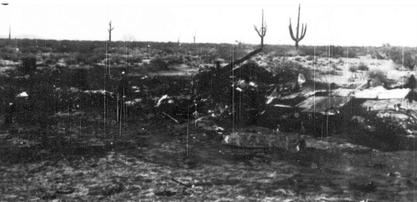
A 12/11/54 photo (courtesy of Bob McCutchen) of the site of the first USAF Thunderbird fatality which occurred when Captain George Kevil crashed his Republic F-84G into the area around Luke Aux #4.

The last aeronautical chart depiction which has been located showing Luke AF #4 still open was on the March 1966 Phoenix Sectional Chart.
It depicted Luke AF #4 as having 3 paved runways, with the longest being 3,800'.
The Luke Aux #4 airfield was apparently closed at some point in 1960,
as it was labeled "closed" on the September 1960 Phoenix Sectional Chart.

"Luke AF Aux #4" was depicted as a closed airfield on the August 1971 USAF Tactical Pilotage Chart (courtesy of Chris Kennedy).
Like Luke Aux #3, the property of this field was apparently transferred to the City of Phoenix,
as it was depicted as "Luke Auxiliary Field #4 (City of Phoenix)" on the 1988 USGS topo map.

A 1997 aerial photo of Luke Aux #4 by Steve Hoza, author of the book "Best Place in the Country".

A circa 2001 aerial view showed that Luke Aux #4 consisted of three 4,000' paved runways arranged in an equilateral triangle,
like the large number of other Luke satellite fields.
The runways remained in fairly decent condition, with no sign of any buildings at the site.
Luke Aux #4 was still depicted as an abandoned airfield on 2002 aeronautical charts.
Steve Hoza reported in 2003 of Luke Aux #4, "This has changed little since I [he took the 1997 aerial photo].
Mike & I have visited this on the ground & the pavement is still in relatively good shape."

As seen in a 2005 aerial photo looking northwest by Jim Baker of Hikari Photography,
the runways of Luke Aux #4 appear to remain in the same condition.

A 2008 photo by Richard Winkler of the remains of a Luke Aux #4 runway.
Richard observed, “The condition of the old airfield is poor.
The runways have been reduced to gravel with the east side runway being almost completely overgrown by brush, which might indicate it was used the least.
The south & west runways are in similar condition, some brush, some garbage discarded by uncaring individuals
but for the most part a darn good option in the event of an emergency landing.
Interestingly, I have spent enough time around WWII aircraft to know the smell of radial engine oil & asphalt
and on the southern most runway, there is still a large saturated area of oil in the gravel/asphalt as if something had sat there for a long period of time.
Maybe my imagination is running wild, but it's neat to think about.”

A 8/10/08 aerial view of the remains of the Luke Aux #4 runways.

A 4/13/15 aerial view by Doug Landers looking southeast at the site of Luke Aux #4.

A 3/10/19 aerial view by Tim Gagnon looking northeast at the remains of Luke Aux #4.
Luke Aux #4 is located northeast of the intersection of West Patton Road & Ogden Road, 6 miles southwest of Wittmann.
____________________________________________________
____________________________________________________
This site covers airfields in all 50 states.