Abandoned & Little-Known Airfields:
Southeastern West Virginia
© 2002, © 2026 by Paul Freeman. Revised 2/15/26.
This site covers airfields in all 50 states: Click here for the site's main menu.
____________________________________________________
Please consider a financial contribution to support the continued growth & operation of this site.
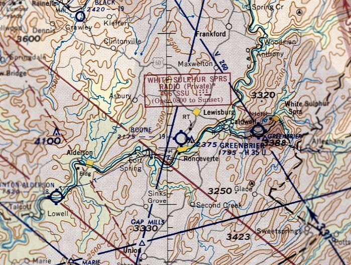
Boone Airport (2nd location) (revised 5/3/22) - Greenbrier Airfield (revised 2/15/26) - Princeton Airport (revised 10/12/25)
Ronceverte Airport / Boone Airport (original location) (revised 3/4/20) - Watoga Airport / Huntersville Airport (added 1/12/23)
____________________________________________________
Watoga Airport / Huntersville Airport, Huntersville, WV
38.097, -80.094 (Northwest of Roanoke, VA)
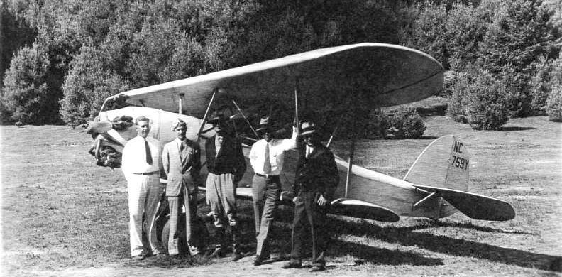
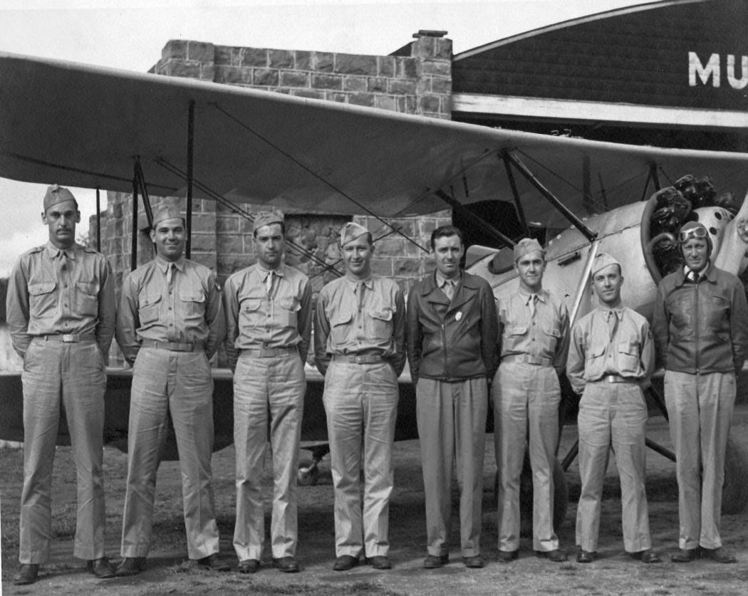
A 9/4/33 photo of 5 men & Bird CK biplane NC759Y at Watoga Airport (from the WV CCC Museum, via John McDonald).
The date of establishment of this small general aviation airport has not been determined.
The earliest depiction which has been located of Watoga Airport was a 9/4/33 photo of 5 men & Bird CK biplane NC759Y (from the WV CCC Museum, via John McDonald).
According to Jim Grant, “N759Y was serial #4020, powered by a 5 cylinder Kinner radial.”
According to The Blue Book of American Aviation, the Watoga Airport was operated by CCC Company 1525 at Camp Watoga, which was engaged in building Watoga State Park.
In a rare level of continuity the same CCC Company worked there from 1933-1942.
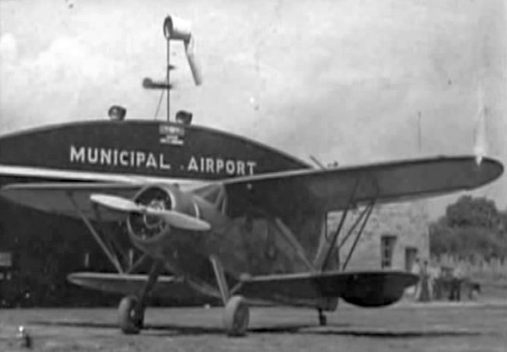
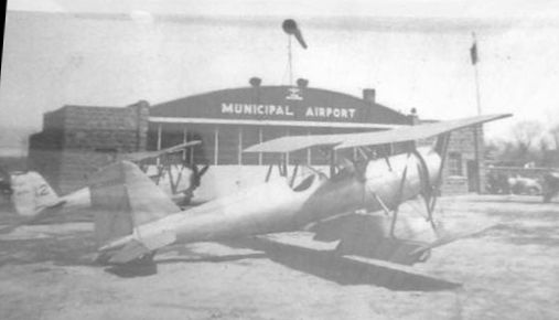
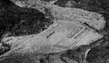
The earliest airport directory reference which has been located to Huntersville Airport was in the 9/1/34 Commerce Department Airway Bulletin (according to John McDonald).
It described Huntersville Airport as an auxiliary airfield located 8 miles southwest of Huntersville, south of Camp Watoga, having a 2,600' sandy clay runway.
The earliest aeronautical chart depiction which has been located of Huntersville Airport was on the November 1934 Huntington Sectional Chart (courtesy of John McDonald).
It depicted Huntersville Airport as an auxiliary airfield.
The last aeronautical chart depiction which has been located of Huntersville Airport was on the November 1942 Huntington Sectional Chart (courtesy of John McDonald).
It depicted Huntersville Airport as an auxiliary airfield.
Huntersville Airport was evidently closed (for reasons unknown) at some point between 1942-44,
as it was no longer depicted on the May 1944 Huntington Sectional Chart (according to John McDonald).
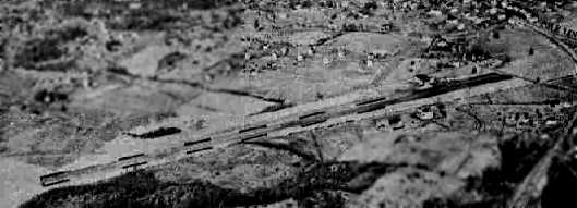
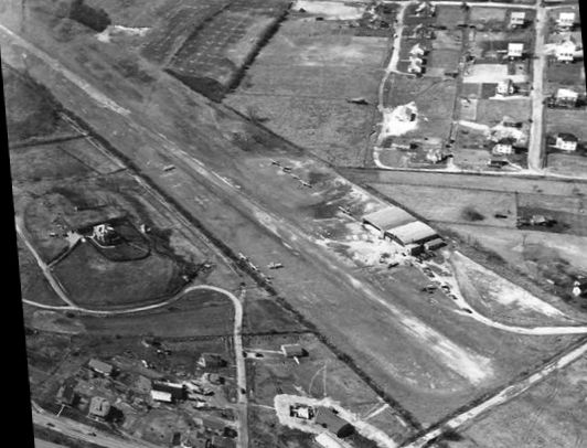
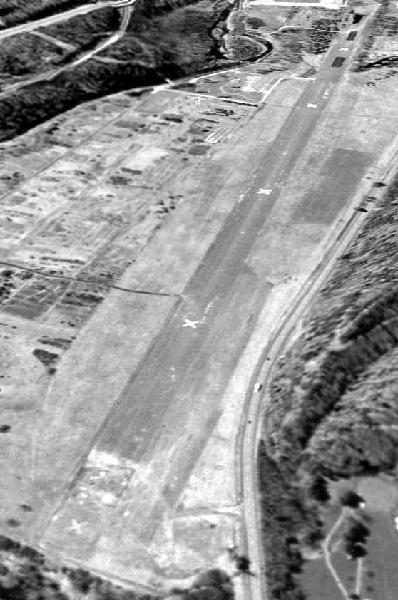
The earliest photo which has been located of Huntersville Airport was a 1957 aerial view.
The airfield appeared to still be in use, as the clearing was maintained, and the northwest/southeast unpaved runway remained quite distinct.
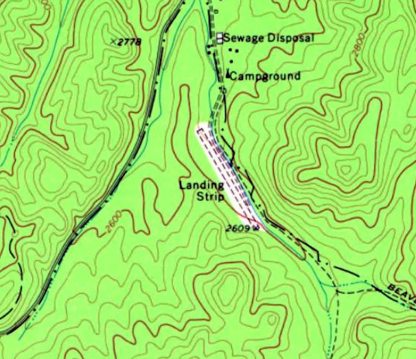
Huntersville Airport may have continued to see some use in at least an unofficial capacity,
as the 1977 USGS topo map still depicted an unpaved northwest/southeast runway, generically labeled “Landing Strip”.
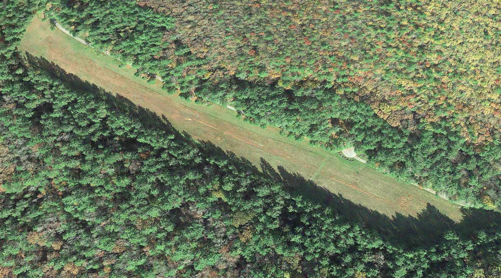
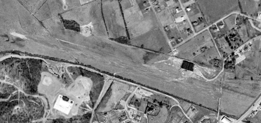
A 2016 aerial view shows the Huntersville Airport runway remains clear & maintained.
Thanks to John McDonald for pointing out this airfield.
____________________________________________________
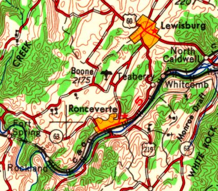
Ronceverte Airport / Boone Airport (original location), Ronceverte, WV
37.763, -80.479 (Northwest of Roanoke, VA)
Ronceverte Airport, as depicted on the April 1944 Winston-Salem Sectional Chart.
This small general aviation airport was evidently established at some point between 1942-45,
as it was not yet depicted on the 1939 USGS topo map or the August 1942 Winston-Salem Sectional Chart.
The earliest depiction which has been located of Ronceverte Airport was on the April 1944 Winston-Salem Sectional Chart.
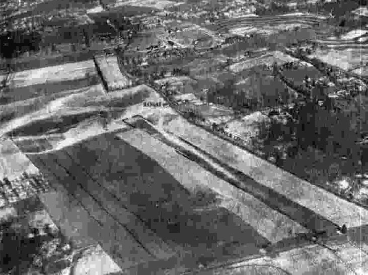
The only photo which has been located of Ronceverte Airport
was a circa 1942-45 aerial view from the 1945 AAF Airfield Directory (courtesy of Scott Murdock).
It depicted Ronceverte as having a single grass runway with one small hangar.
The 1945 AAF Airfield Directory (courtesy of Scott Murdock) described Ronceverte Airport
as a rectangular property having a single 1,800' north-northeast/south-southwest runway.
The field was said to have a single 50' square wooden hangar, and to be owned & operated by private interests.
At some point between 1945-50 the airport was evidently renamed Boone Airport,
as that is how it was labeled on the 1950 Winston-Salem Sectional Chart.
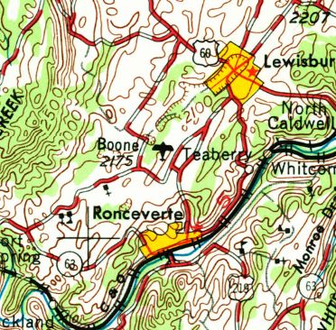
Boone Airport, as depicted on the 1955 USGS topo map.
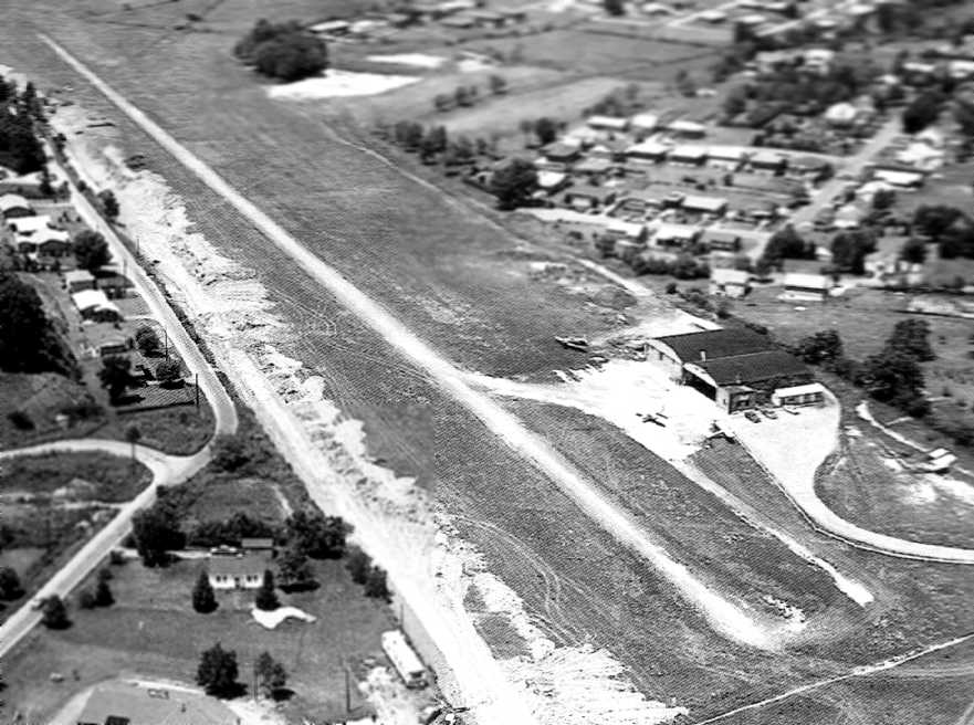
Nothing recognizable as an airfield was depicted at the site of Ronceverte/Boone Airport on a 1957 aerial photo.
The last aeronautical chart depiction which has been located of Boone Airport was on the January 1958 Winston-Salem Sectional Chart.
It depicted Boone as having a mere 1,900' unpaved runway.
Boone Airport was evidently closed at some point in 1958,
as it was no longer depicted on the July 1958 Winston-Salem Sectional Chart.
Although a 2013 aerial view showed no recognizable trace remaining of Ronceverte Airport,
its location was presumably the rectangular grass field in the center of the photo.
The site of Ronceverte Airport is located west of the intersection of Route 37 & Route 219.
____________________________________________________
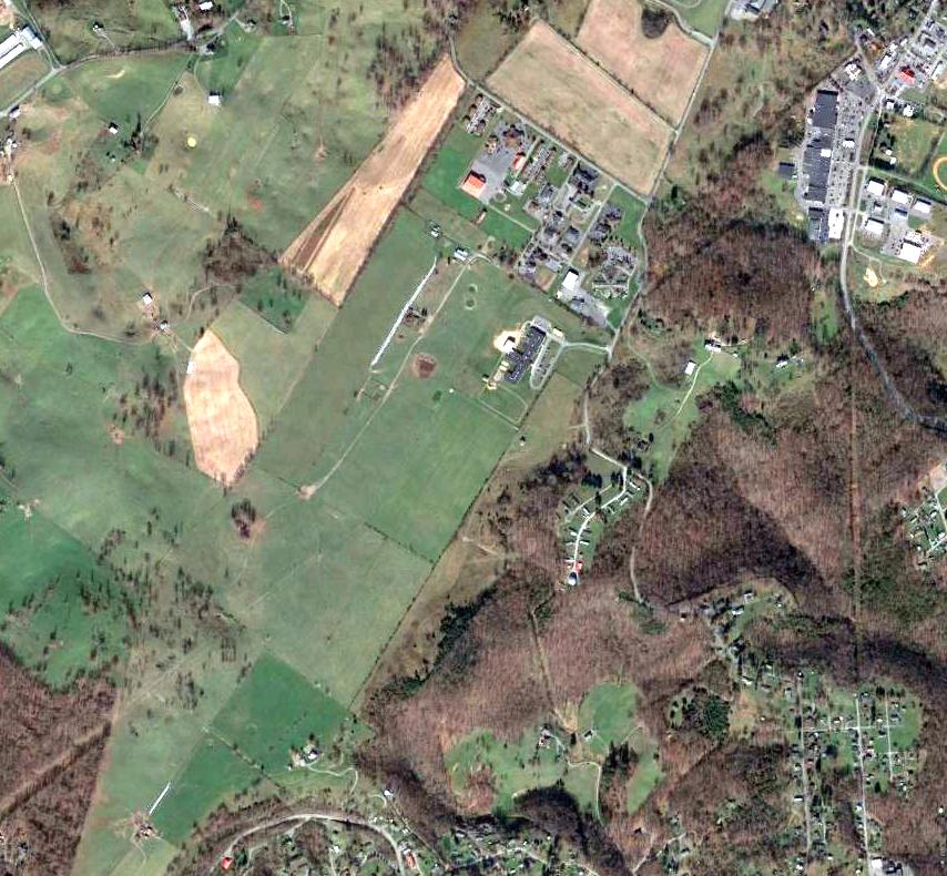
Boone Airport (2nd location), Ronceverte, WV
37.774, -80.475 (Northwest of Roanoke, VA)
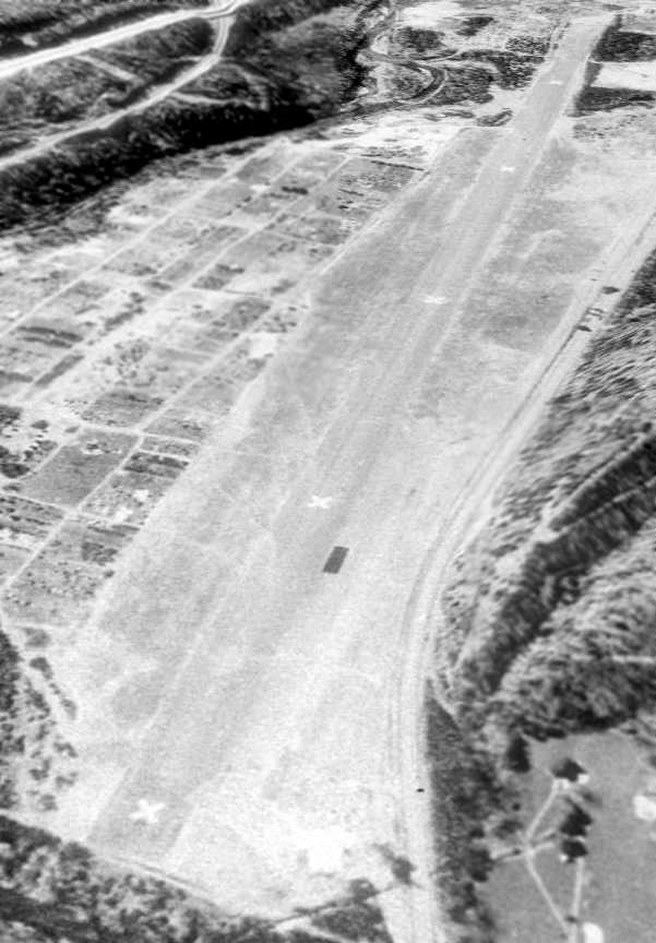
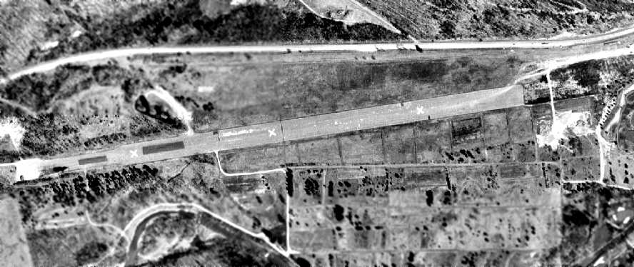
The 2nd location of Boone Airport, as depicted on the 1957 USGS topo map.
Photo of the airport has not been located.
At some point between 1955-57, Boone Airport was evidently relocated from its original location a mile to the southwest,
as that is where it was depicted on the 1957 USGS topo map.
A 1957 aerial view depicted Boone Airport as an open grass landing area, with an airport circle marking along the east side.
Boone Airport was not yet depicted on the January 1961 Winston-Salem Sectional Chart.
The earliest aeronautical chart depiction which has been located of the 2nd location of Boone Airport was on the October 1965 Winston-Salem Sectional Chart (courtesy of Ron Kunse).
It depicted Boone as having a 1,900' unpaved runway.
Boone Airport, as depiicted on the 1966 USGS topo map.
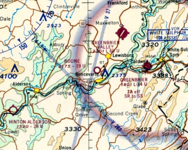
The last depiction which has been located of Boone Airport was on the April 1969 Winston-Salem Sectional Chart.
It depicted Boone as having a 1,900' unpaved runway.
Boone Airport was evidently closed at some point between 1966-71,
as it was no longer depicted on the 1971 USGS topo map, which instead depicted the Greenbrier East High School close by.
Nothing recognizable as a former airfield was depicted at the site of Boone Airport on a 1971 aerial photo.
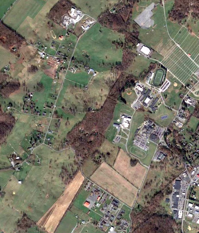
A 2013 aerial view showed no recognizable trace remaining of the 2nd location of Boone Airport.
The site of the 2nd location of Boone Airport is located northwest of the intersection of Route 37 & Route 219.
____________________________________________________
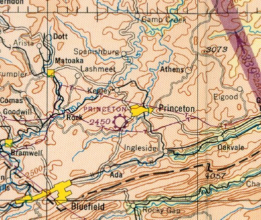
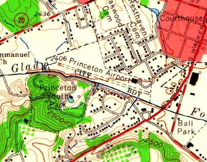
Princeton Airport, Princeton, WV
37.36, -81.11 (West of Roanoke, VA)
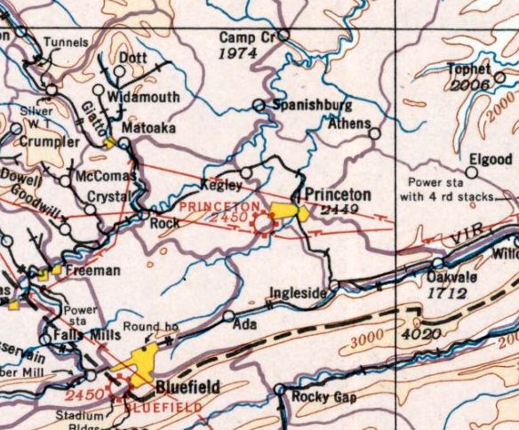
Princeton Airport, as depicted on a the March 1935 Winston Salem Sectional Chart.
The date of construction of Princeton Airport is unknown.
The earliest depiction which has been located of Princeton Airport was on the March 1935 Winston Salem Sectional Chart,
which depicted Princeton as a commercial/municipal airport.
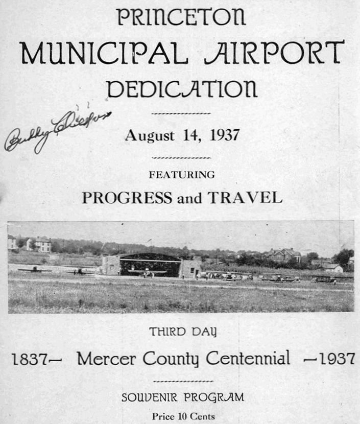
The program for the 8/14/37 dedication of Princeton Airport (courtesy of Rick Harshbarger).
The earliest photo which has been located of Princeton Airport was an undated photo on the program
showing 6 light single-engine aircraft in front of an arch-roof hangar.
The Airport Directory Company's 1937 Airports Directory (courtesy of Bob Rambo)
described Princeton Airport as having 2 runways, with the longest being a 3,800' shale strip.
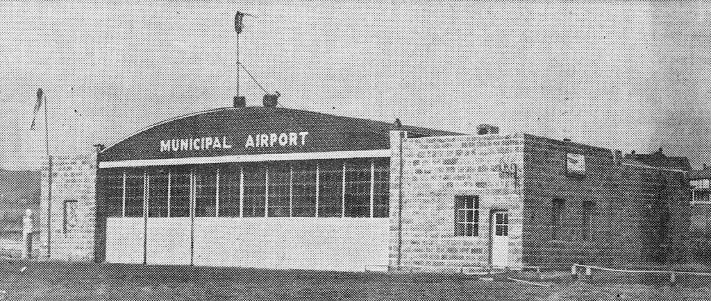
An undated photo of the Princeton Municipal Airport hangar from a 1939 article (courtesy of Rick Harshbarger).
Vic Allen recalled, “My mother & father moved to Princeton in 1939 & both of them soloed out of this airport.”
George Lynch III reported, “My father, George E. Lynch Jr., and Jim Tolly operated the Princeton Airport prior to WWII & during the war.
Eventually, my father (George E. Lynch Jr.) bought out Jim Tolly.”
Bill Mitchem recalled, "My father in 1940 received his pilot's ticket at the Princeton Airfield."
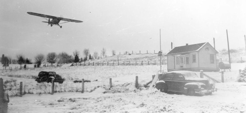
A 1941 photo showed a Piper J3 Cub on short final approach to a snowy Princeton Municipal Airport (courtesy of Rick Harshbarger).
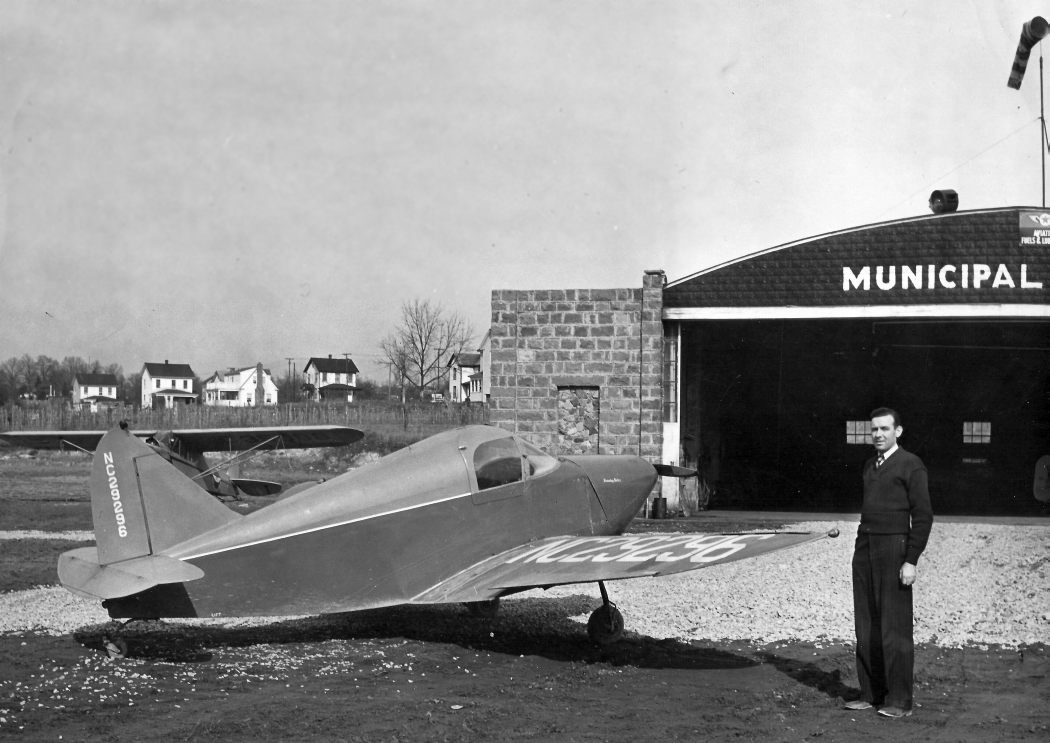
A 1942 photo by George Lynch III of “my father [George Lynch Jr.] standing in front of a Culver Cadet” with the Princeton hangar in the background.
Charlie Bell recalled, “I well remember the old Culver Cadet.”
A circa 1942-45 photo by George Lynch III of “a class of student flyers & my father [George Lynch Jr. standing outside the Princeton Airport hangar.
They had a contract with the government to teach students to fly. Many a student learned to fly out of Princeton.”
A still from a 1943 movie of a Waco in front of the Princeton Airport hangar (courtesy of Rick Harshbarger).
The movie was about Ruth Gwinn, who according to Rick Harshbarger was “the first woman flight instructor in WV.”
A circa 1940s photo of 2 biplanes (model undetermined) in front of the the Princeton Municipal Airport hangar (courtesy of Rick Harshbarger).
A circa 1943-45 aerial view looking northeast from the 1945 AAF Airfield Directory (courtesy of Scott Murdock)
depicted Princeton as having a single northwest/southeast runway, with some buildings on the east end.
Apparently the runway at Princeton had been shortened almost by half by 1944,
the 1944 US Army/Navy Directory of Airfields (courtesy of Ken Mercer)
described the field as having only a 2,000' runway.
The 1945 AAF Airfield Directory (courtesy of Scott Murdock) described Princeton Municipal Airport
as a 36 acre rectangular property within which was a single 2,000' shale east/west runway.
The field was said to have a single 90' x 66' stone hangar,
to be owned by the City of Princeton, and to be operated by private interests.
The March 1945 Winston-Salem Sectional Chart (courtesy of Dick Merrill) depicted Princeton as a commercial/municipal airport.
Doug Ayres recalled, “Louis Lynch was the charter pilot for his uncle, who purchased [Princeton] Airport during WWII when it was used for training pilots.
However, at discharge Louis used his WWII B-25 pilot pay to bail out financially his uncle.
But within a year they did not make enough money to continue the operation, so Louis went to work at a Princeton hot dog stand.”
A circa 1940s photo by George Lynch III of “Jim Tolley & my father [George Lynch Jr.] at the Princeton Airport standing in front of a Waco that they owned.”
Charlie Bell recalled, “The Piper Cub in the background may very well be the one Marvin Grubb & I once flew with Wilson Dunn in a Stinson Voyager to Blacksburg to pick up.”
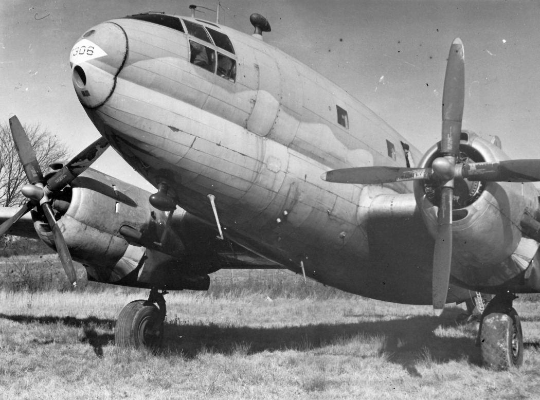
A circa 1940s photo by George Lynch III of a WW2 surplus Curtis C-46 Commando transport at Princeton Airport.
George reported, “George Lynch even flew an old C-46 into Princeton that became the clubhouse of the local Boy Scouts at that time.”
Charlie Bell recalled, “The old C-46 commando was there for a long time.”
George Lynch III reported, “The City of Princeton kept threatening not to renew the lease & turn it into apartment buildings after the war.”
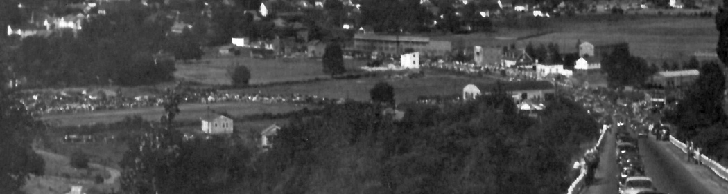
A circa 1950s photo by George Lynch III looking southwest at Princeton Airport showing the crowd gathered for an airshow.
George reported, “George Lynch used to put on airshows out of the Princeton Airport.”
David McKay recalled, "I have vivid memories of playing in the hulk of an old airplane that sat next to one of the 2 hangars at the site.
That was probably in the 1951-52 timeframe. The strip was grass with some gravel as is described.
There we never more than a couple of people around & they didn't bother me as I played."
William Kennedy recalled, “I grew up in nearby Matoaka, WV. I remember the Princeton Airport clearly.
My Mother had a friend who had an airplane there. My first plane ride was from there.
Once he flew over Matoaka real low bouncing his wheels off the flat roof of the Bowling house on Graveyard Hill.
There was also an old WW2 bomber that sat at the end of the runway for many years.
I think the Boy Scouts owned it. It later ended up being painted red & green.”
Vic Allen recalled, “I was born & raised in Princeton & still live there.
As a kid back in the mid-1950s I would often sit on my aunt's back porch, which overlooked the airport, and spend hours watching planes take off & land.
My first helicopter ride was from that airport in the late-1950s.
The helicopter was owned by one of the local bakeries & they were doing a promotion.
I noticed that it was reported to have 2 runways. I can only remember it having one runway.”
Dave Wohlford recalled, “Bob Stewart of Bluefield VA was the helicopter pilot, the chopper owner was Betsy Ross Bakery in Bluefield WV.
It was a Bell 47, the bakery was owned by Mr. Stewart's father-in-law, a Mr. Feuchtenberger.”
A circa 1950s aerial view looking north (courtesy of Rick Harshbarger) depicted a dozen light aircraft on Princeton Airport.
 40.76,
-73.31
40.76,
-73.31
A 3/30/55 USGS aerial view depicted Princeton Municipal Airport as having an unpaved northwest/southeast runway
with 5 single-engine aircraft parked outside next to the hangar on the northeast side.
Eddie Shields recalled, “I took my first airplane ride there with my uncle's PA-12 in 1956. His last name was Croy.”
A circa 1950s aerial view looking northwest along Princeton's runway.
A hangar was seen at the northeastern end of the runway, around which were parked 3 single-engine light aircraft.
A circa 1950s aerial view looking southwest showing Princeton Airport in the background (courtesy of Rick Harsbarger).
Dave Wohlford recalled, “In the late 1950s & early 1960s the place was busy on the weekends & not much went on during the week.
I do not recall ever seeing a night landing in Princeton but I recall there was a rotating beacon on the big stone hangar & smudge pots along the runway.
The opening of the much larger Mercer County Airport near Bluefield dealt a death blow to Princeton around 1961.
In 1961 about a thousand feet of the west end had been X'ed closed for landing.
It was still used for heavy aircraft on takeoff & run out, probably due to the swampy nature of that end of the field at that time.
The runway numbers were 10 & 28.
To aid the pilot in determining the wind direction the Princeton Airport had both a tetrahedron & a windsock.”
The last photo which has been located of Princeton Airport was a 3/17/61 USGS aerial view.
It showed on a single aircraft parked outside next to the hangar on the northeast side.
The 1962 AOPA Airport Directory described Princeton Municipal Airport as having a singe 2,800' shale Runway 9/27,
and listed the operator as Princeton Flying Service.
=
The 1962 USGS topo map depicted Princeton Airport as having a single unpaved northwest/southeast runway,
with a single building on the northeast side.
Frank Grose recalled, "I grew up in the Richlands, VA area, and took flying lessons at Princeton...
the closest FBO that offered them (at an airport we liked).
I remember passing Roselawn Cemetery (and thinking, 'If I crash, I'll be in a place like that' as we passed it).
I remember looking down at the ball fields when on final
(and thinking, 'They think they are having fun, but I'm the one who is having fun').
I remember turning base leg right down over the little valley through which the creek runs.
I remember looking down on Roselawn Cemetery while on downwind."
Frank continued, "The runway was turf, but with finely crushed gravel on the well-used portion.
Princeton had 2 nice hangars, made of grey stone blocks.
In the one next to the office (in which was hanging a large wooden prop from a Ryan Standard) was the shop facilities.
The one to the west is where the airplanes were kept.
The hangars & tie-downs (and the large wind tetrahedron) were on the north side of the strip.
In the 1963 era, two fellows operated the airport... one's first name was Buddy."
According to Lanny, “Buddy's last name was Sessler. His partner in operating Princeton Flying Service was Doug Barger.”
Frank Grose recalled, "These 2 guys built one or more Monocoupes from scratch.
They had a large, heavy jig, into which they clamped all the 4130 tubing before tack welding it together.
Instead of installing a radial engine, as was standard for Monocoupes, they put a flat engine of some type.
The nose looked very 'Piper-ish', but the rest was pure Monocoupe.
As I recall, they sold the first one, had another one flying there, another airframe was out of the jig & being welded up,
and another airframe in the jig being built, the last time I was there.
I've not seen nor heard of a flat-engined Monocoupe since.
These were not EXPERIMENTAL planes, so they must have bought the rights to manufacture them.
I'm sure the jig was something they bought.
My last flight from Princeton was in 1964 with Lake Watkins, my instructor, in Aeronca 11AC Chief N9450E."
Dave Wohlford recalled, “The Princeton airport was closed around 1963.
When the City of Princeton closed it the Honaker family attempted to get the property back.
It had been given to the city for an airport for as long as an airport remained on it.
In the event the airport was closed the deed called for its return to the Honaker's or their estate.
The Family had the copies of the deeds but the city & county could not locate them.
A battle ensued & the city prevailed. It was kept very quiet.
Probably the city attempted to declare eminent domain & the Honaker family could not afford the fight.
I was told this by a former employee of mine who was a member of the Honaker family.
My 86 year old mother was the city clerk for the city at the time this fight took place & she still won't talk about it.”
Princeton Airport was still depicted on the 1964 Winston-Salem Sectional Chart (according to Chris Kennedy).
The last aeronautical chart depiction which has been located of Princeton Airport was on the April 1965 Winston-Salem Sectional Chart.
It depicted Princeton Airport as having a 2,700' unpaved runway.
Dave Wohlford recalled, “As a teenager I had a friend that lived at the west end of the runway.
It remained untouched for a few years after it closed until the city built the hospital about 3/4 of the way toward the western end of the runway around 1965 or 66.
Later they built the City Hall Complex on the eastern end & have used the center area for recreation & city garage up to this time [2013].
The Princeton Airport was no longer depicted on the March 1966 Winston-Salem Sectional Chart.
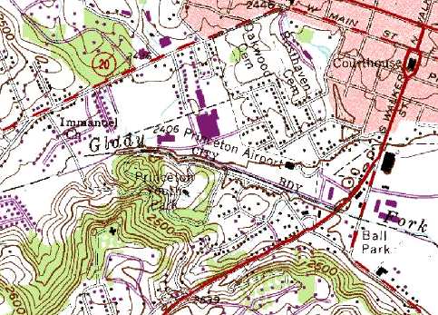
Strangely, the 1979 USGS topo map still contained the label "Princeton Airport",
even though it showed several streets & buildings within the bounds of the former airport.
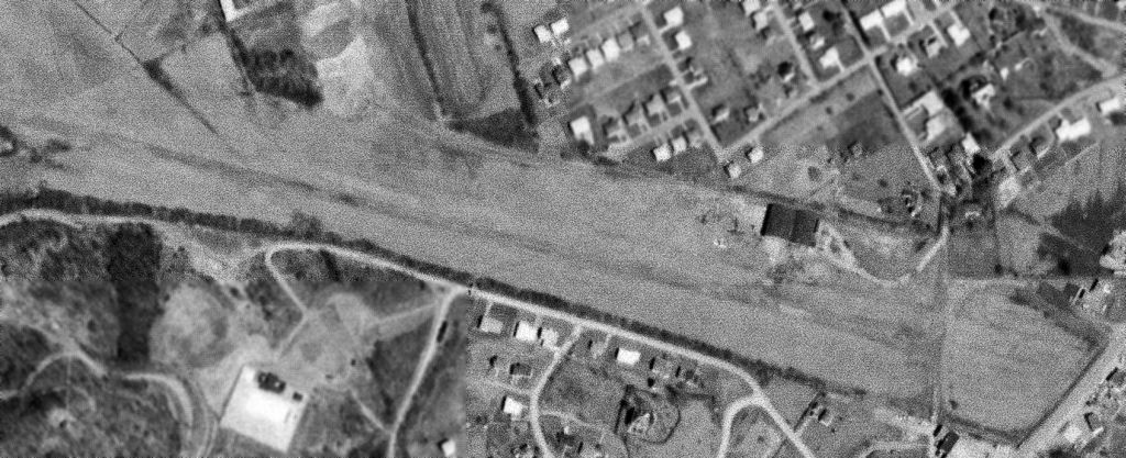
In the 1996 USGS aerial photo of the site of Princeton Airport,
The property had been reused for several large buildings & a parking lot,
but the orientation of the runway remained recognizable, and the former hangar remained standing.
However, a clue to the former occupant of this property may still be seen on the street signs -
as the site is located southwest of the intersection of Route 19 & Airport Drive.
Former Princeton Airport pilot Frank Grose recalled, "I was by the area of the old airport a couple of years ago.
It has changed so much that it was difficult to determine where the runway was. Only the surrounding terrain looked the same."
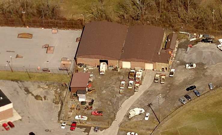
Delbert Whitlow reported in 2006, “The hangar... has been the maintenance department garage for the City of Princeton for probably 30 or 40 years.
In addition to the Princeton Community Hospital & it's huge parking lot,
the airport property is the site of the City Hall, the city's recreation building & softball field.”
K. W. Reed reported in 2007, “The black roofed building that sits just beyond the softball field's center field
is the old hangar that is currently used by the city as a maintenance garage.
Airport Drive is found by following the street off the ball field's right foul line one block north & taking the 1st right.
The large building in the left center of the photo is the Princeton Community Hospital.
The area in the lower left is the Princeton City Park & Pool.”
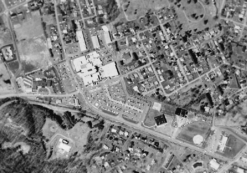
Vic Allen reported in 2008, “City hall is at the east end of the runway & Princeton Community Hospital is on the west end.
The City of Princeton still uses the hangars to maintain city vehicles & equipment.”
A circa 2008 aerial view looking north shows the same dual-arch roof hangar visible in the 1950s photo.
Dave Wohlford reported in 2013, “The 2 hangars are still being used as the city garage.
Morrison Drive was built on the southern side of the runway along the creek bank, to connect the hospital to Courthouse Road (old 460).
You can still find remnants of the old runway in the ball fields if you know where to look.
The runway ended well past the present green houses on the west end.
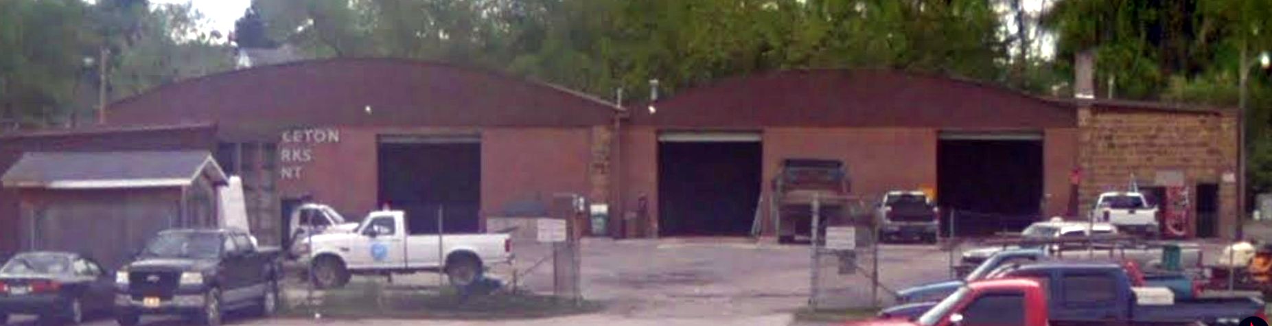
A 2018 photo looking north showed at the former Princeton Airport dual-arch roof hangar, now marked “Princeton Parks Department”.
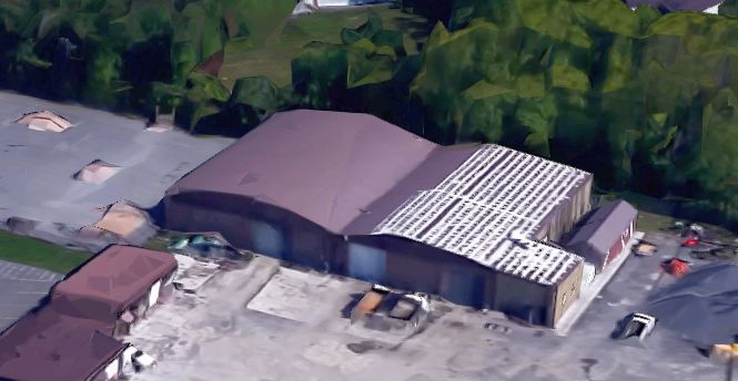
A 2023 3-D aerial view looking north showed the former Princeton Airport dual-arch roof hangar.

A 2023 aerial view showed the hangar remained as the sole remaining element of Princeton Airport.
____________________________________________________
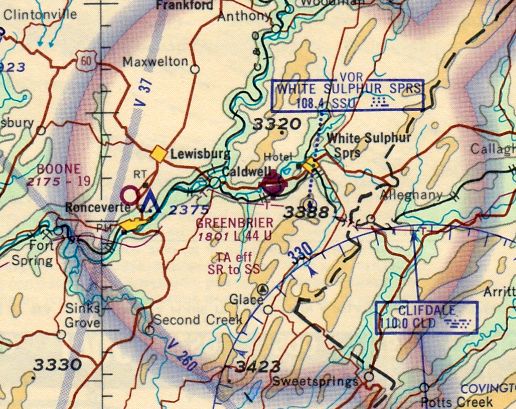
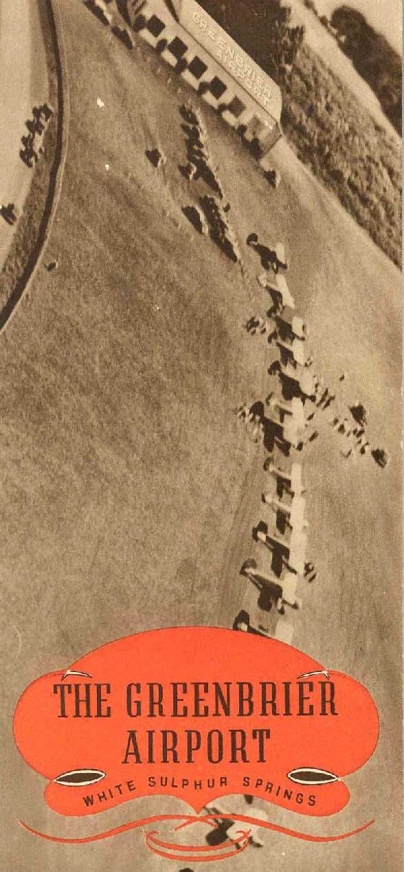
Greenbrier Airport / Greenbrier Army Airfield, White Sulphur Springs, WV
37.777, -80.333 (Northwest of Roanoke, VA)
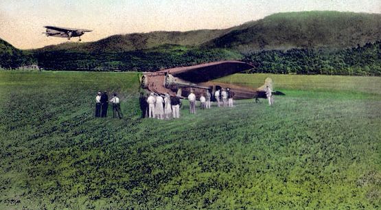
A colorized circa 1932 photo of 2 Fokker TriMotors at the Greenbrier Airport (courtesy of Mark Hess).
The airfield of the prestigious Greenbrier Resort was officially opened on 9/1/30,
according to an article in the 8/24/30 Charleston Gazette (courtesy of Mark Hess).
According to an article in the 6/16/63 issue of the Sunday Gazette-Mail, (courtesy of Mark Hess),
“Even as the country was In the throes of a depression, Greenbrier Airport began operation;
families of wealth & social position locked up their town houses & country estates & flocked to The Greenbrier,
escaping the operating expense involved in their own property, but seeking the mode of life the resort offered.”

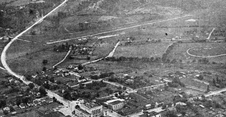
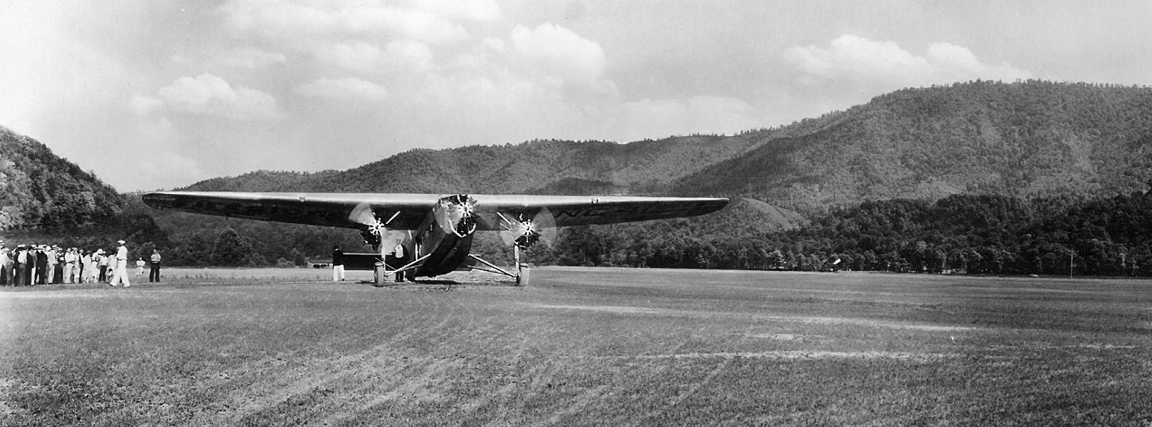
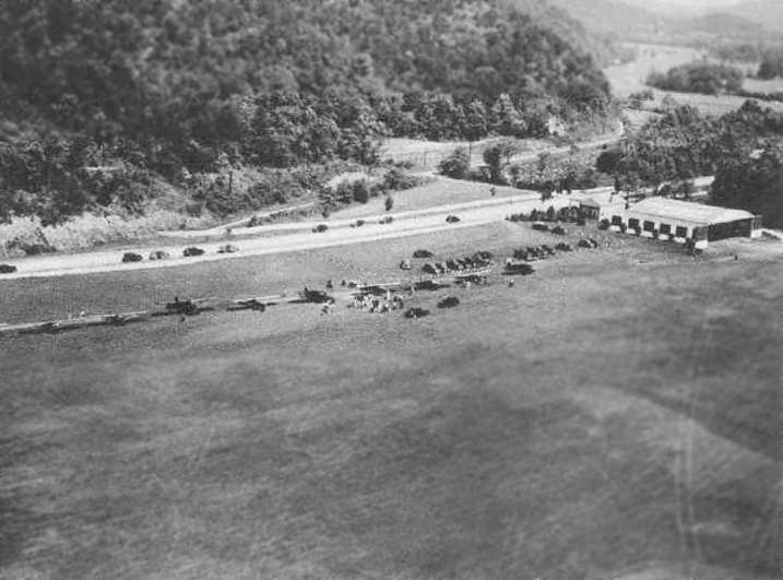
A circa early 1930s aerial view looking northwest at Greenbrier Airport.
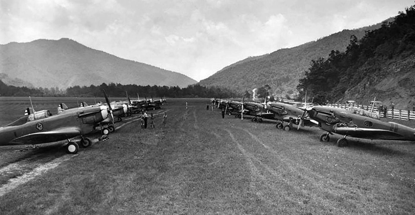
The photo showed parked near the hangar 17 single-engine military biplanes & 1 much larger biplane, and presumably showed the July 1932 visit of the 33rd Pursuit Squadron.
Greenbrier Airport was the location of the first visit of a U.S. Army Air Corps Squadron to a West Virginia Airport in July 1932,
by 18 planes of the the 33rd Pursuit Squadron from Langley Field, VA under command of Capt H. H. George,
according to the 7/7/32 issue of the Richmond Times Dispatch (courtesy of Mark Hess).
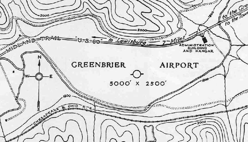
The earliest directory listing which has been located of the Greenbrier Airport
was in the 1934 Department of Commerce Airfield Directory (according to Chris Kennedy).
It described Greenbrier as having an irregularly-shaped turf landing area, measuring 5,000' x 2,500'.
According to Doug Ayres, Greenbrier Airport “became what was known as 'the smoothest grass airport in the world'.
Every famous aviator, from Lindbergh to Doolittle & Earhart used & lauded it.”
The Greenbrier Airport, as depicted on the March 1935 Winston-Salem Sectional Chart.
Chris Kennedy pointed out that the 1935 USGS topo map depicted the 2 hangars of the Greenbrier Airport,
and the open field of the landing area, but the map did not label it as an airfield.
"I guess the map makers didn't recognize it as an airstrip."
The cover of a vintage (1930s?) brochure for the Greenbrier Airport (courtesy of Willard Keeling) depicted a row of planes in front of the hangar.
A circa 1930s photo of a Ford Tri-Motor at Greenbrier Airport (courtesy of Rick Harshbarger).
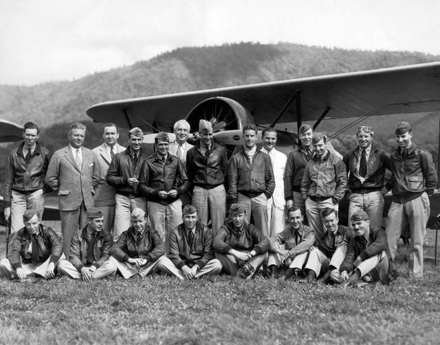
A circa mid-1930s photo of Army Air Corps flyers & Greenbrier Airport staff in front of an unidentified Army biplane (courtesy of Rick Harshbarger).
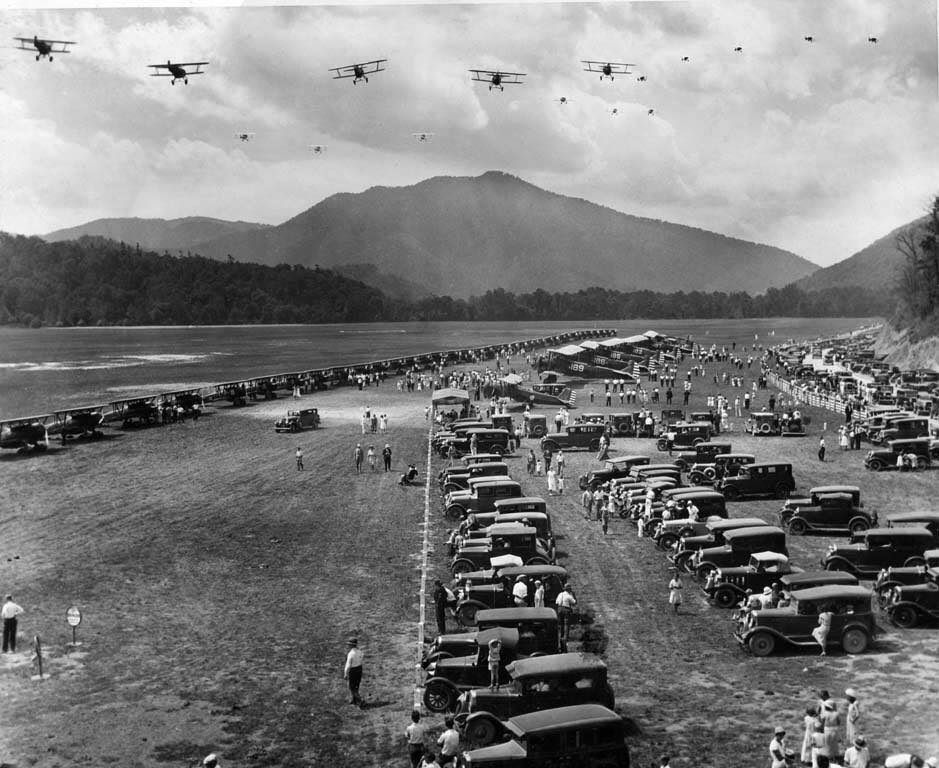
A circa mid-1930s photo of a a large number of Army Air Corps biplanes performing an airshow at Greenbrier Airport.
The Airport Directory Company's 1937 Airports Directory (courtesy of Bob Rambo)
described White Sulphur Springs Airport as having an irregular 5,000' x 2,500' sod landing area.
The aerial photo in the directory depicted a single hangars at the northeast corner of the field.
A circa 1938 photo of a visit of Army Air Corps Consolidated P-30 fighters (identified by Charlie Bell) at Greenbrier Airport (courtesy of Rick Harshbarger).
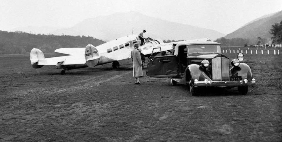
A 1938 photo of a Lockheed Electra at the Greenbrier Airport.
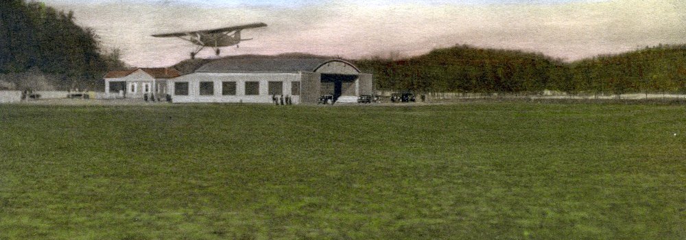
A circa 1930s colorized postcard photo of a high-wing monoplane over the Greenbrier Airport hangar.
A circa 1930s-40s aerial view (courtesy of George Lynch III) looking east at the Greenbrier Airport before it was paved,
with a large grass airfield with an airport circle marking in the center, and the single hangar in the background.
Strangely there were no aircraft visible on the field.
Daniel Weikle recalled, “My Uncle, Wheeler Weikle, started a business called The Greenbriar Air Service.
It was probably late 1930s / early 1940s. Wheeler trained pilots for WWII as a civilian contractor.
My father & Wheeler flew tourists around the Greenbriar Airport in his biplane.
My father told the story about painted rocks marking the runway & how he ran the plane into one of the rocks & damaged the wing.
My father until the day he died searched for a picture of Wheeler’s shack with the Greenbriar Air Service sign.
We have turned Dad’s garage into a 'hangar' complete with windsock & his B-26 painted on the garage door.”
In 1942, the Greenbrier hotel was taken over by the Federal Government, and renamed Ashford General Hospital.
The airfield was taken over by the government & renamed Greenbrier Army Airfield. It was used to support the operations of the hospital.
A circa 1943-45 aerial view looking northeast from the 1945 AAF Airfield Directory (courtesy of Scott Murdock)
depicted Greenbrier Airport as having a single east/west runway.
According to Doug Ayres, “In early 1943 one side of the 500 yard wide, mile long grass 'landing strip' was paved in concrete.
Thus was created a 3,400' long runway on which one-stop flights of then the military version of the DC-4 could make the flight from first England,
then soon after D-Day, France to Greenland and on non-stop to Ashford General.
Only the best Army Air Force pilots could make the landing there, inasmuch as mountains were at both ends.
But, as a 13 year old ‘airplane nut’ I watched with great fascination how these pilots managed to navigate thru a narrow gap between the 2 mountains at the west end,
then literally slip the aircraft almost sideways to lose altitude, managing to ‘stick it’ on the far western end of the concrete runway.
Or, at least somewhere on concrete. For there never was an accident or overrun in its nearly 3 years of service.
Also, not incidentally, the southern portion of the mile-long former grass runway was filled with temporary barracks to house 500 German Prisoners Of War,
who did the grunt work, extremely well, for Ashford General Hospital.
Some returned years later, as hotel guests and/or residents of the United States.”
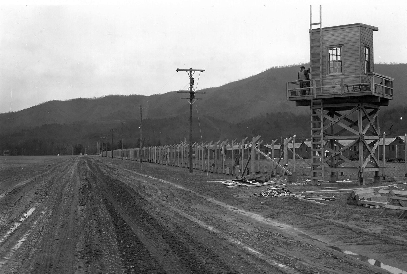
A circa 1943-44 photo looking west along the Prisoner Of War camp on the south side of Greenbrier Airport (courtesy of Rick Harshbarger).
According to Mark Hess, the Prisoner Of War camp at the Greenbrier Airport operated until 1944.
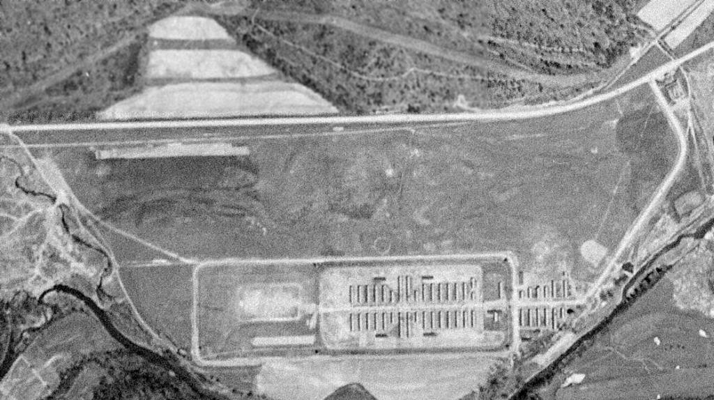
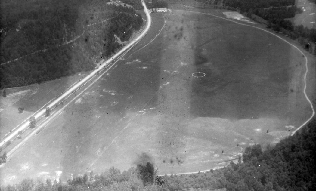
A 4/28/44 USGS aerial view depicted Greenbrier Airport as having a single east/west unpaved runway.
The complex of structures adjacent to the south side of the runway was the a Prisoner Of War camp
whose occupants worked at the nearby Ashford General Hospital during WWII.
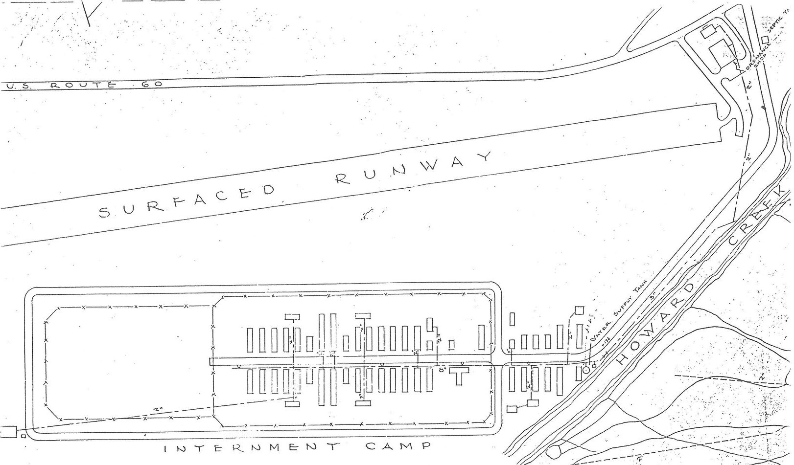
A 1940s plan of the Prisoner Of War camp which was built adjacent to the south side of Greenbrier Airport (courtesy of Rick Harshbarger).
The 1945 AAF Airfield Directory (courtesy of Scott Murdock) described Greenbrier Airport
as a 165 acre irregularly-shaped property within which was a single 3,500' concrete east/west runway.
The field was said to have a single 100' x 80' steel hangar,
to be owned by the U.S. Government, and to be operated by the Army Air Forces.
The March 1945 Winston-Salem Sectional Chart (courtesy of Dick Merrill)
labeled Greenbrier Airport with its wartime designation of “Greenbrier AAF (Aux)”.
Doug Ayres recalled, “Louis Lynch did some charter flying out of the Greenbrier Airport for the long-time owner of the hangar & operation - Oscar Tate.”
The Greenbrier Airport returned to normal civilian operations in 1946.
According to Mark Hess, the buildings adjacent to the south side of the runway
were sold by the War Assets Administration in September 1946.
Presley Melton reported that the Howard DGA-15 (N9125H) he eventually purchased “was owned from 1946-55 by Charles Tate of Greenbrier Airlines.”
The Greenbrier Airport was served for an unknown period by Greenbrier Airlines,
which offered a non-scheduled air taxi service connecting Greenbrier with Roanoke, Charleston & Washington.
The airline was operated by Charles Tate, a former TWA pilot.
In an undated advertisement (courtesy of Willard Keeling), Greenbrier Airlines boasted of a 25 year perfect safety record.
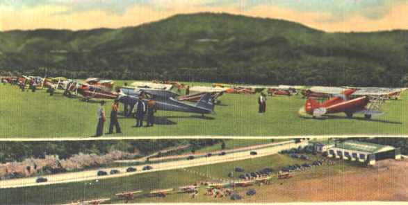
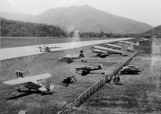
A 1950 aerial view looking at Greenbrier Airport (courtesy of Rick Harshbarger), showing an amazing dozen large aircraft, including DC-3s & several WW2 warbirds.
A DC-2 at the Greenbrier Airport, from a circa 1950s brochure (courtesy of Willard Keeling).
An aerial view looking northeast at the Greenbrier Airport hangar, from a circa 1950s brochure (courtesy of Willard Keeling).
A map of the Greenbrier Airport from a circa 1950s brochure (courtesy of Willard Keeling).
The brochure described Greenbrier Airport as totaling 175 acres, with a 5,000' x 2,500' grass landing area.
A 100' x 82' metal hangar & the administration building were located on the northeast side of the field, along Route 60.
The operator was listed as Tate-Clark Flying Service.
A circa 1950s postcard of the Greenbrier Airport (courtesy of Willard Keeling).
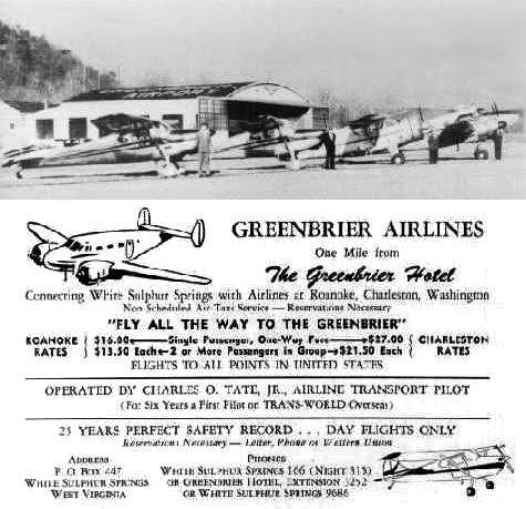
A circa 1950s advertisement for Greenbrier Airlines (courtesy of Willard Keeling),
with several of their aircraft pictured in front of the hangar at the former Greenbrier Airport.
A circa 1950s aerial view looking northwest at Greenbrier Airport, showing 7 single-engine aircraft parked near the hangar.
A circa 1950s postcard aerial view looking west at Greenbrier Airport, with a DC-3 among smaller planes near the hangar.

A circa 1950s aerial view looking east at the Greenbrier Airport hangar & 5 single-engine planes,
photographed by Don Elmore on 8/11/85 from a display inside the Greenbrier Airport.
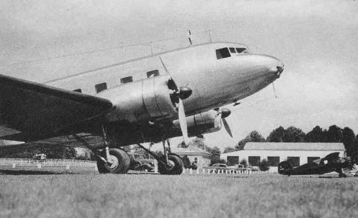
A circa 1950s photo looking west at a lineup of aircraft at Greenbrier Airport, including several DC-3s,
photographed by Don Elmore on 8/11/85 from a display inside the Greenbrier Airport.
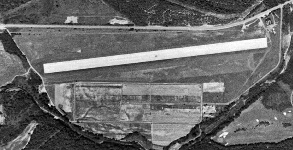
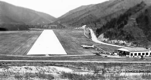
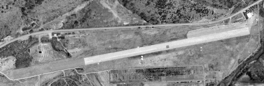
An 8/9/56 USGS aerial view depicted Greenbrier Airport as having a single east/west paved runway,
with 2 light aircraft next to the hangar on the northeast side.
The remains of the WW2 Prisoner Of War camp were still recognizable adjacent to the south side of the runway.
The January 1958 Winston-Salem Sectional Chart depicted Greenbrier Airport as having a 3,5900' paved runway.
A 1993 Washington Post article revealed that construction began in 1959 of a secret bomb shelter underneath the Greenbrier Hotel,
designed to protect the entire US House of Representatives & Senate.
The Greenbrier Airport may have had a role as a support facility for this secret bomb shelter.
Frank Cain reported, "I had the occasion about 1960-61 to meet Charlie Tate, the pilot who flew out of Greenbrier Airport (WVA).
At the time, he flew a Lockheed 10A & a Cessna 180 out of the strip. A very engaging fellow.
I dropped in to refuel (at the time, I was flying a D18 Twin Beech) and got to meet him.
I often wondered whatever happened to his 10A - a remarkable airplane.
It was still the same as it was when it was built in 1937 - all the instruments were original, only the radios were updated -
he had a Narco Mark II "Coffee Grinder" radio in it!"
The Greenbrier Airport's runway was apparently paved by 1962,
as it was described in the 1962 AOPA Airport Directory as having a single 5,000' paved runway.
The first jet to land at Greenbrier Airport was a new 4-engine Lockheed JetStar business jet
which landed at “the newly expanded Greenbrier Airport” in July 1962,
according to the 7/27/62 issue of the Marietta Daily Journal (courtesy of Mark Hess).
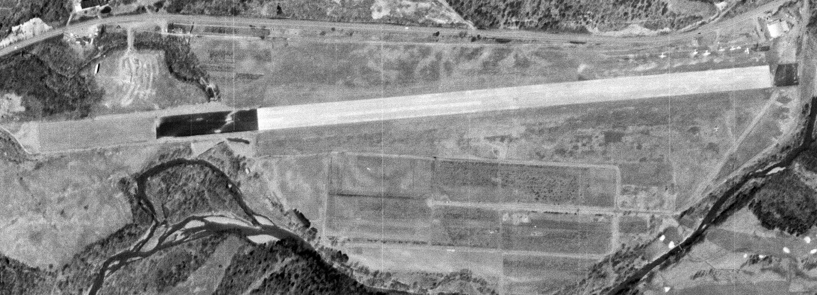
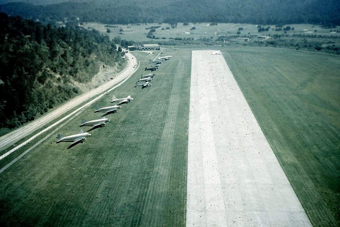
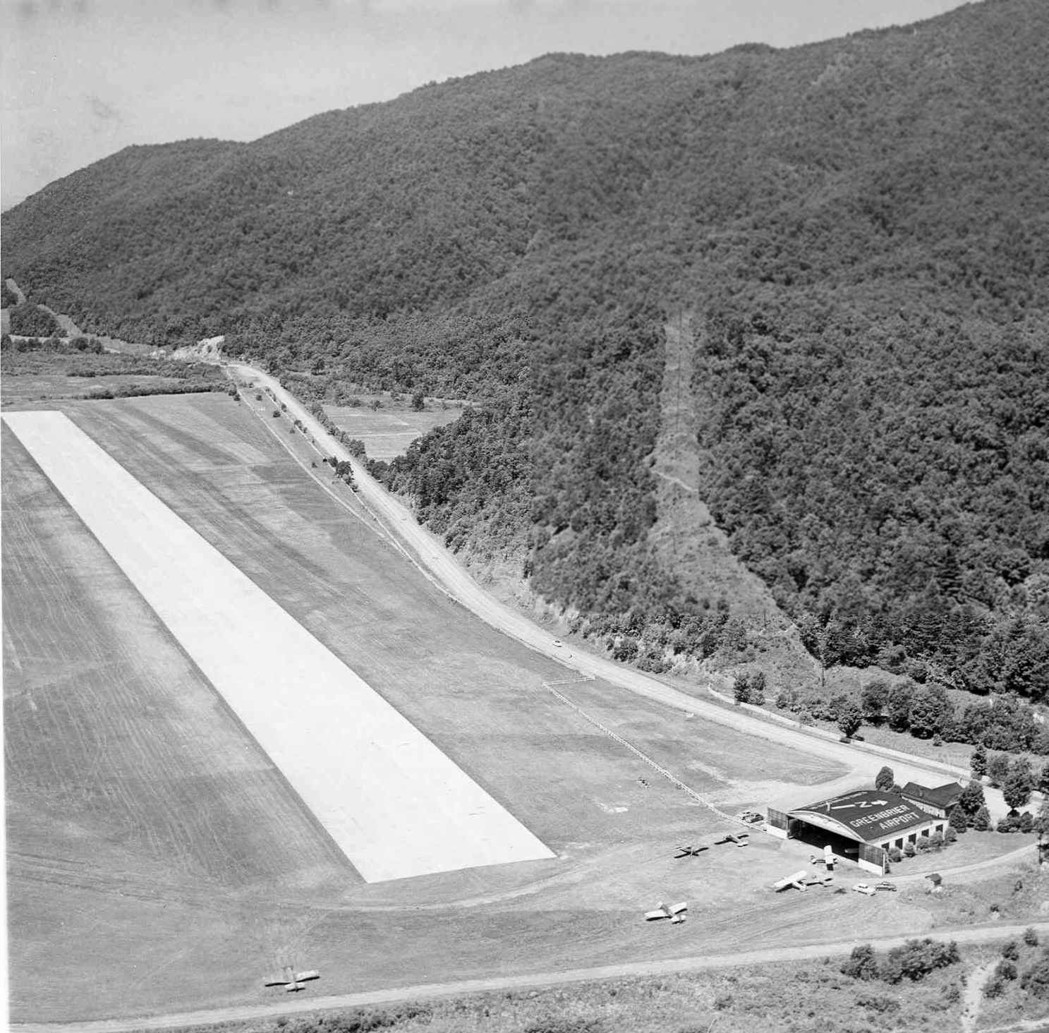
A 3/24/63 USGS aerial view depicted Greenbrier Airport as having its runway lengthened in both directions since 1956.
A total of 7 light aircraft were parked next to the hangar on the northeast side.
The remains of the WW2 Prisoner Of War camp were still recognizable adjacent to the south side of the runway.
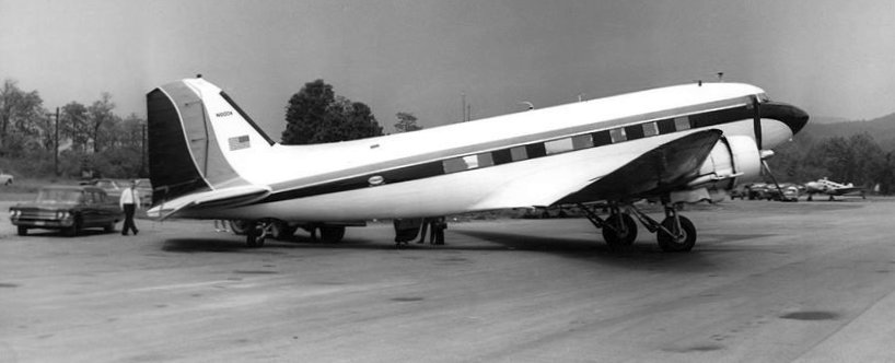
A 1963 photo of a Douglas DC-3 airliner at Greenbrier Airport (courtesy of Rick Harshbarger).
George Lynch III recalled, “My father (George Lynch Jr.) was Oscar Tate’s chief pilot for Greenbrier Airlines at White Sulphur Springs.
I worked there as a lineman from 1963-68 for Oscar Tate. My father taught Chuck Tate, Oscar Tate’s son to fly.
Chuck earned his commercial pilot’s license & became an experienced pilot.
Chuck continued to operate the business at White Sulphur after his father & mine retired.
The business had declined as the Greenbrier was pushing business to Lewisburg & the town became interested is selling the airport property to the Greenbrier.”
Strangely the 1965 USGS topo map still didn't depict Greenbrier Airport at all.
George Parker recalled, “Greenbrier Airport in White Sulphur Springs had a storied history of thousands of people
and many important people who passed through heading to the world famous Greenbrier Hotel.
I vividly remember watching the U.S. Air Force Lockheed Jetstar bringing Vice-President Hubert Humphrey [circa 1965-69]
to The Greenbrier through Greenbrier Airport on several occasions, he really liked the Hotel.”
Rick Claymore recalled, “As an airplane-obsessed kid growing up in Charleston, WV,
this was a regular stop on car trips on Route 60, which passed alongside the runway.
This was in the late 1960s / early 1970s.
We stopped for a few minutes to see what was on the runway, usually a couple high-end private planes.
Once, there was a new Schweitzer 2/33 parked there, fresh out of the box.”
Robert Cooper recalled, “From 1966 through the 1970s I flew many trips into & out of Greenbrier
as a corporate pilot with Texas Gulf Sulphur Company.
First in a Lockheed Learstar, then a Cessna 421 & lastly a Citation 500.
I enjoyed meeting Oscar Tate & there were many interesting incidents in getting in & out when the weather was down.
The company also operated a Saberliner & Jetstars & G1s into Greenbrier.”
Glenn Parker recalled, “The Greenbrier Airport... I used to work there as a lineman in the early- to mid-1970s during the summers while going to college.
The city of White Sulphur Springs owned the airport.
Charles 'Oscar' Tate Jr. managed the airport as well as being owner & chief pilot of Greenbrier Airlines, an air charter - air taxi operation.
Oscar, as he was known, had over 30,000 hours of flight time.
During its heyday, Greenbrier Airlines flew over 10,000 passengers per year using 11 single- & twin-engine piston aircraft,
ranging from Cessna 172 to the Lockheed 12A.
Of course, most of the traffic was for The Greenbrier [Hotel].
It is interesting to note that one of his pilots was a former manager of the old Princeton, WV airport - George Lynch.”
Glenn continued, “The airport had a 5,200' x 150' paved runway, concrete/asphalt.
The largest planes I knew of landing there was (for pistons) a DC-6B and (for jets) the Lockheed JetStar, Gulfstream III, and a BAC-111.
I personally have put in 1,000 gallons of JP-1 in a Gulfstream II & have put in 1,200 gallons in a Convair 580.
Ironically, the busiest day I can remember was on 6/5/68,
the same day that the new Greenbrier Valley Airport in Lewisburg, WV opened for business.
On that day there were 425 operations at Greenbrier Airport, due to simultaneous departure & arrival of 2 large conventions at The Greenbrier.”
In 1968 the much larger Greenbrier Valley Airport was built 6 miles to the northwest, and it would eventually replace the original Greenbrier Airport.
The last aeronautical chart depiction which is available of the original Greenbrier Airport was on the April 1969 Winston-Salem Sectional Chart.
It depicted Greenbrier Airport as having a single 4,400' paved east/west runway.
A 4/16/70 USGS aerial view depicted a dozen light aircraft parked near the Greenbrier Airport hangar.
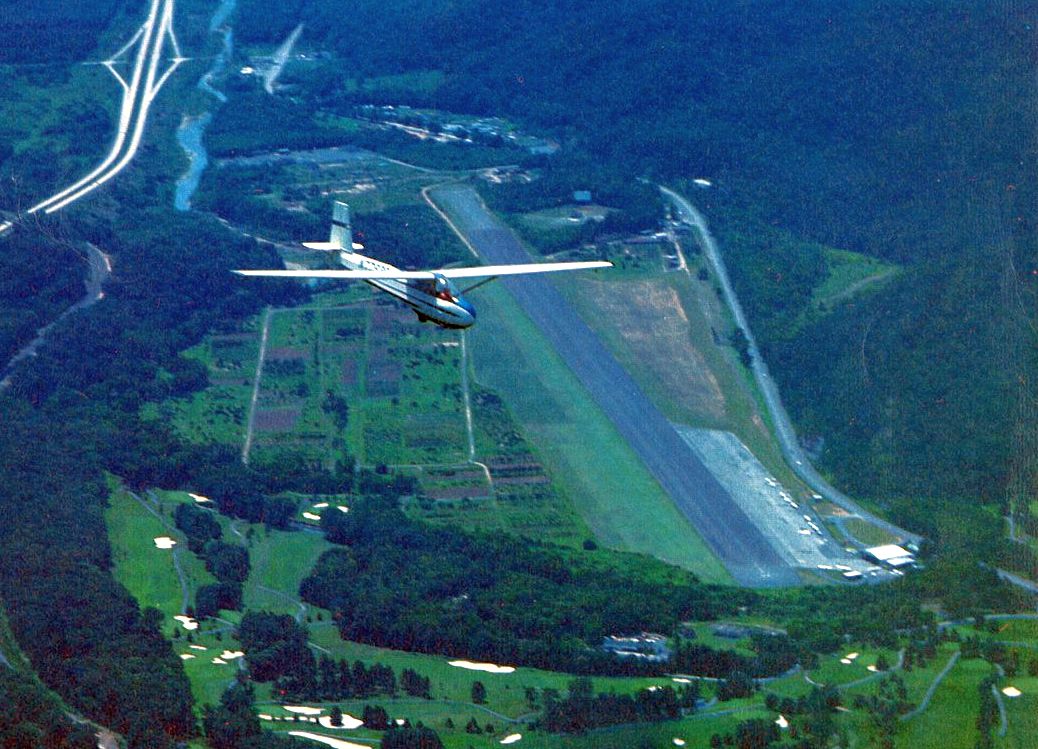
A circa 1970s aerial view (courtesy of Rick Harshbarger) looking west at a glider (model undetermined) over Greenbrier Airport, with several light planes parked on the ramp.
According to Mark Hess, “The last known date of it being opened was in July 1974.”
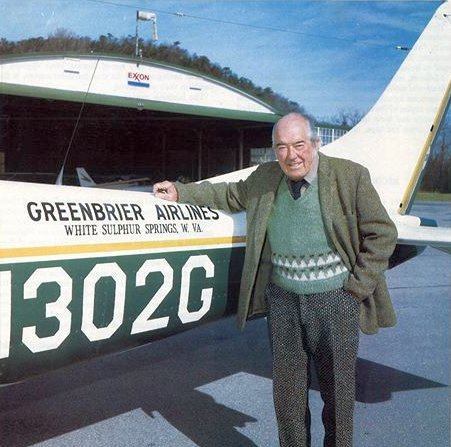
A late 1970s photo (courtesy of Rick Harshbarger) of Oscar Tate & one of his Greenbrier Airlines planes in front of the Greenbrier Airport hangar.
Richard Clarke recalled, “I flew into the Greenbrier Airport in 1978 in a Cherokee. You had to stay sharp to slide in between the hills.
At that time, I think the hangar was gone or pretty derelict, but the Administration building was there & had a bunch of photos of the field's history.
The Electra that had been used to fly people in from the major cities was broken & parked in the area near the Administration building.
The Electra had a chain holding the left landing gear in place, so it looked as if that had something to do with an accident. No one talked of operating it again.”
However, George Lynch III recalled, “Chuck Tate was killed in an accident in approximately 1978.
Soon afterwards, the business closed & the airport was sold to the hotel.”
Asil Ingram recalled, “I grew up in the White Sulphur Springs area
and watched the Greenbrier Airfield or as it was known to us as the Greenbrier Hotel Private Airport.
What caught my attention was the DC-2 pictured on a postcard [above].
That (possibly the same) DC-2 sat parked by the FBO hangar building untill at least December 1981.
Sometime after my departure from WV I found out through correspondence with school friends
that the airport had been closed & was being used as a drag strip for unmodified street cars.
Also through my family which were CSX employees I was told that the sole purpose of the airfield
was to support important government employees who would come to the Greenbrier Hotel.”
The Greenbrier Airport was described by the 1982 AOPA Airport Directory (courtesy of Ed Drury)
as having a single 5,200' asphalt/concrete Runway 8/26.
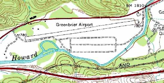
The 1983 USGS topo map depicted the Greenbrier Airport as having a single paved runway, with a single hangar at the northeast corner of the field.
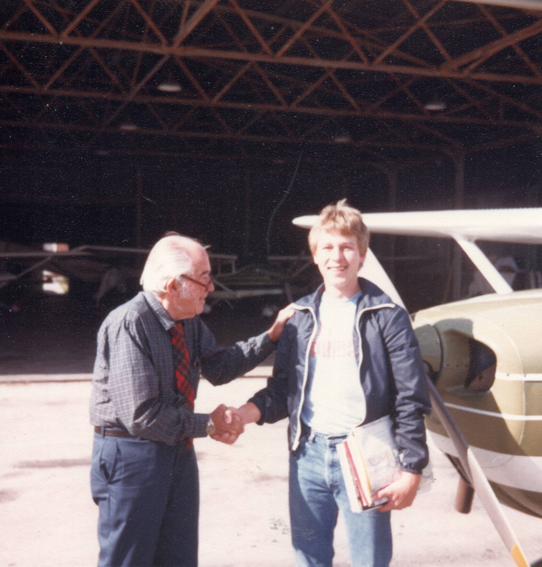
An October 1983 photo of Oscar Tate II congratulating Kevin Swiger for passing his private pilot checkride, in front of the Greenbrier Airport hangar.
Kevin Swiger recalled, “I learned to fly at the White Sulphur Springs Airport back in the early 1980s.
My primary instructor was 'Rocky' Stone, but I did have a few opportunities to fly with Mr. Tate as my instructor & I am so honored to have spent time in an airplane with that man.
I wish now that I had spent more time talking to him about his experiences in aviation. I really miss the SSU airport & still imagine how it was back then as I drive by from time to time.”
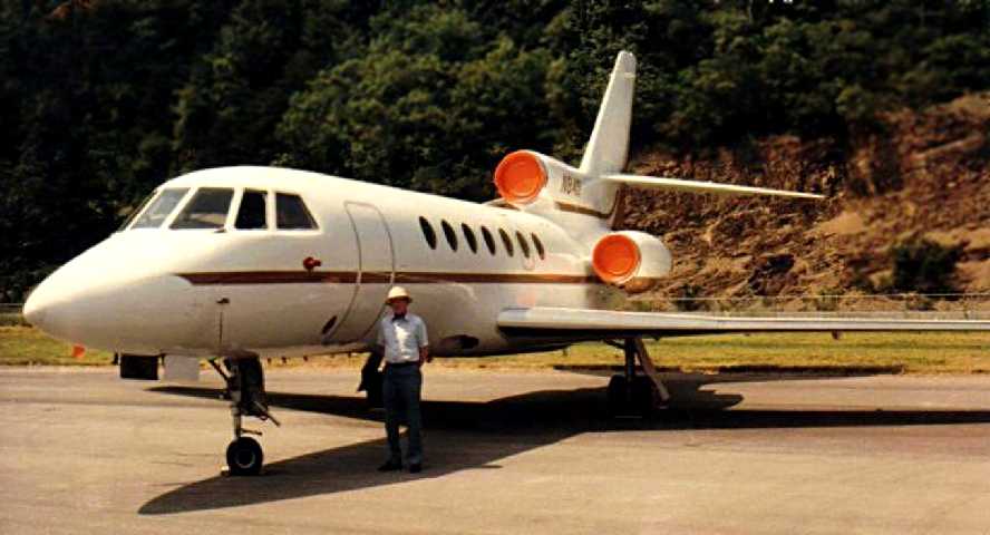
An 8/10/85 photo by Glenn Parker of George Parker in front of a Falcon 50 trijet at Greenbrier Airport, on the occasion of the retirement party of Charles O. "Oscar" Tate, Jr..
George recalled, “There were quite a lot of celebrities there including the head of the VA Dept. of Aeronautics, WV U.S. Senator Jennings Randolph, WV Governor Arch Moore, Jr. & others.”
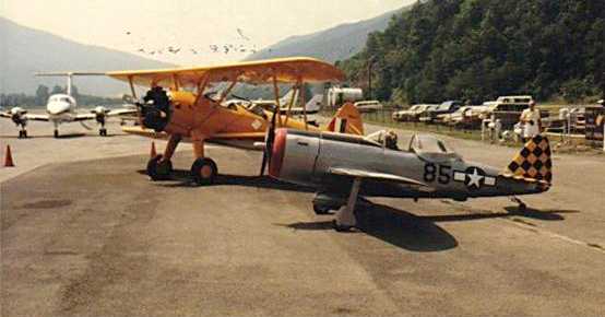
An 8/10/85 photo by Glenn Parker of a Stearman biplane & a subscale homebuilt P-47 replica at Greenbrier Airport,
on the occasion of the retirement party of Charles O. "Oscar" Tate, Jr..
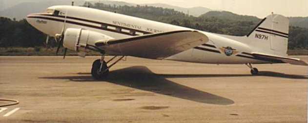
An 8/10/85 photo by Glenn Parker of Don Elmore's DC-3 “Sentimental Journey” at Greenbrier Airport,
on the occasion of the retirement party of Charles O. "Oscar" Tate, Jr..
An 8/10/85 photo by Glenn Parker of a 1939 Lockheed 12A Electra Junior departing Greenbrier Airport.
An 8/11/85 photo by Don Elmore of a 1939 Lockheed 12A Electra Junior in front of the Greenbrier Airport hangar.
According to George Lynch III, “It is a Lockheed 12 that belonged to Oscar Tate & Greenbrier Airlines. The FAA number on the airplane was N1108.”
An 8/11/85 photo by Don Elmore of a Stearman in front of the Greenbrier Airport hangar.
Jessica Tate reported, “My grandfather was Charles Oscar Tate, Jr. ('Oscar'), and my father was Charles Oscar Tate, III ('Chuck').
Both were owners of Greenbrier Airlines operating out of the airport adjacent to The Greenbrier in White Sulphur Springs.
My father was killed in an aircraft accident, returning from a taxi service trip to Dayton OH in a Cessna on 9/1/86.
Conditions were foggy & it seems he had passed the runway & was turning to make his landing when he struck the mountainside about 1/2 mile from the airport.
I was 4 years old. My grandfather had retired by that time. Around the time of my father's death, the airline was transitioning to the larger airport at Lewisburg, WV.
I remember being on the inaugural flight to the Lewisburg airport but if I'm remembering correctly, my father was already deceased by that time.
My mother attempted to manage the running of the airline for a short time but as a high school teacher & newly-widowed mother, she ultimately sold it.
I know my father was not at all happy about the decision to sell/trade the land which ultimately became part of the golf courses.
I remember 'co-piloting' with my father & him giving a tour of the airport & the planes to my preschool class!
I do know flying was his passion & the airline meant so much to him.”
George Parker recalled, “I was at the airport in 1986 when the last Greenbrier Airlines flight departed
to go to their new home at the Greenbrier Valley Airport in Lewisburg.
I have no pictures, I do not remember the date, and, like a fool, I did not secure a memento from the airport!
Oscar Tate's son, Chuck Tate was now running Greenbrier Airlines out of Lewisburg.”
Both the original Greenbrier Airport & the new Greenbrier Valley Airport were listed in the 1986 Flight Guide (according to Chris Kennedy).
According to Glenn Parker, “The airport, because of being surrounded by hills, was most suited for the slower DC-3, Convairs, F-27, Martin 4-0-4 type of aircraft
who were slower & could loose altitude over the valleys before making a turn-in for a final to the runway.
The advent of the jets really spelled for the demise of the airport
because of their higher speed & need for a straight-in approach void of obstacles (hills).
The handwriting was on the wall & the city & The Greenbrier traded land & cash & the Greenbrier Airport was no more!”
Asil Ingram reported, “I contacted Bob Conte, the Greenbrier Hotel historian,
and said he did not know when the last flight out of the airfield was but knew the airport definitely closed in 1986.”
According to Doug Ayres, “In the 1980s a high school classmate of mine who was Mayor
'traded' the now-surplus WWII airfield to The Greenbrier for a new adjacent water treatment plant.
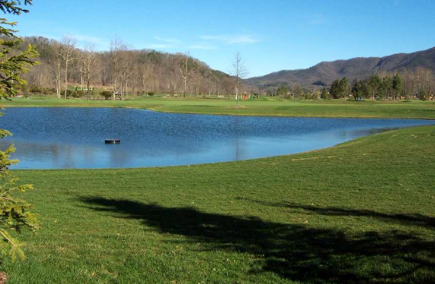
The Greenbrier then built the 18 hole championship class Sam Snead golf course on the former airport.”
The original Greenbrier Airport was closed by 1990, as the 10/26/90 USGS aerial view looking southwest showed the runway to have closed-runway "X" markings painted along it.
The hangar had been removed, but its foundation was still perceptible.
The last photo available showing the original Greenbrier Airport still largely intact was a 3/26/97 USGS aerial view looking southwest.
According to Jonathan Goodish, who recently traveled through the area,
the former Greenbrier Airport was noticeable as a relatively long span of pavement, painted with abandoned runway "X" markings,
and was surrounded by a fence identifying the property as a "Hunting Ground" & "No Trespassing."
CSX Hotels was listed on the signage as the property owner.
A 3/30/00 USGS aerial view looking southwest showed that the eastern third of the Greenbrier runway had been removed at some point between 1997-2000.
Traces of the WW2 Prisoner Of War camp were still recognizable adjacent to the south side of the runway.
Willard Keeling visited the site in 2002, and reported that "the Greenbrier is developing a new golf course on the site of the old airfield.
The site has been completely graded over & planting is now taking place for the new greens.
There is nothing there now that even hints that a airfield was there in the past.
It looks like next spring they will be playing golf on the old airfield."
A 2003 aerial photo showed all traces of the Greenbrier runway having been removed, with golf course construction covering the airport site.
A pretty picture, of a sad sight - a 2003 photo by Willard Keeling of the former Greenbrier Airport, now a golf course.
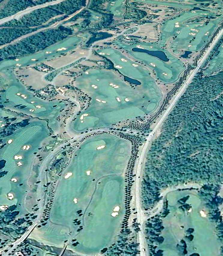
A 7/9/11 USDA aerial view looking southwest showed no trace remaining of the original Greenbrier Airport.
Doug Ayres reported in 2014, “The former POW camp & the mountain to its south now are filled with acreage lots & multi-million dollar homes.”
The site of the Greenbrier Airport is located in between Route 60 & Interstate 64, two miles southwest of White Sulphur Springs.
Thanks to Christopher Stacy for information about Greenbrier.
____________________________________________________
Or if you prefer to contact me directly concerning a contribution (for a mailing address to send a check),
please contact me at: paulandterryfreeman@gmail.com
If you enjoy this web site, please support it with a financial contribution.
____________________________________________________
This site covers airfields in all 50 states.