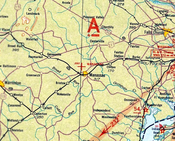
Abandoned & Little-Known Airfields:
Virginia: Prince William & Stafford Counties
© 2002, © 2022 by Paul Freeman. Revised 11/27/22.
____________________________________________________
Please consider a financial contribution to support the continued growth & operation of this site.
Flying T Farm Airfield (revised 5/1/16) - Hartwood Airport (revised 9/1/21) - Libeau Airport / Le Beau Airport (revised 7/10/17) - (Original) Manassas Municipal Airport (revised 1/6/21)
Quantico MCAS Brown Field (revised 10/14/22) - Valley View Airport (revised 8/4/22) - Woodbridge Airport (revised 11/27/22)
____________________________________________________
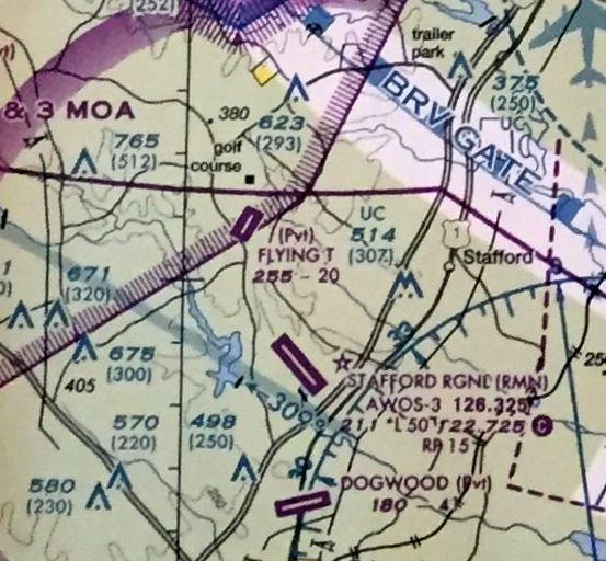
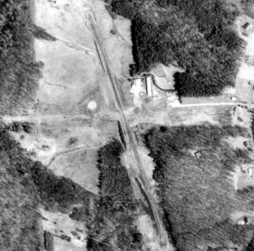
Flying T Farm Airfield, Stafford, VA
38.432, -77.471 (Southwest of Washington, DC)
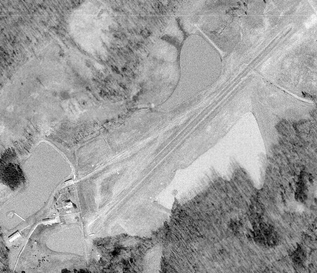
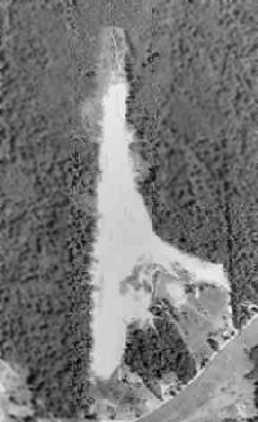
A 3/5/71 USGS aerial view of Flying T Farm Airfield.
Andy Tyler recalled, “My dad built this farm & this 2,000' airstrip with a 2 plane T-hangar in the 1960s to fly our Cessnas (210 & 150) out of.
It was built around 1969 first as a gravel strip then professionally paved.
It was an incredible place to grow up & I had a wonderful childhood there, I was a very lucky young man.”
The Flying T Farm Airfield was not yet depicted on the 1971 Washington Sectional Chart.
The earliest depiction which has been located of Flying T Farm Airfield was a 3/5/71 USGS aerial view.
It depicted a single northeast/southwest runway, with a few small buildings & what appears to be 1 light single-engine plane on the southwest side.
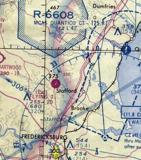
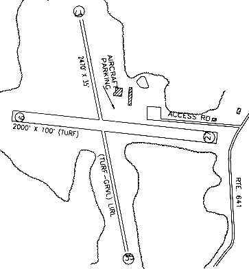
The earliest aeronautical chart depiction which has been located of the Flying T Farm Airfield was on the 1975 Washington Sectional Chart.
It depicted Flying T as a private airfield with a single paved 2,000' northeast/southwest runway.
Andy Tyler recalled, “My Dad was killed when thrown from a horse on the farm & without him my Mother was unable to keep the whole farm
so she sold off the portion with the airstrip & we still own the other half minus the strip.”
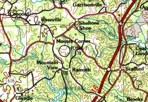
Flying T Farm Airfield, as depicted on the 1989 USGS topo map.
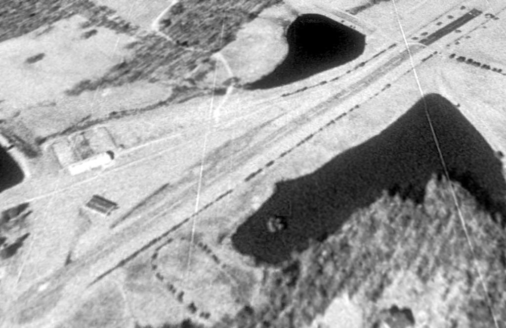
A 1994 USGS aerial view looking north depicted Flying T Farm Airfield
as having a single northeast/southwest paved runway, with a few small buildings on the southwest side.
The February 2009 Washington Terminal Aeronautical Chart depicted Flying T as a private airfield with a single paved 2,000' northeast/southwest paved runway.
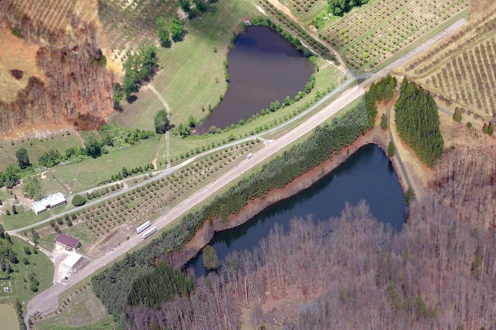
A circa 2010 aerial view looking north depicted Flying T Farm Airfield
as having a single northeast/southwest paved runway, along which a few trailers were parked.
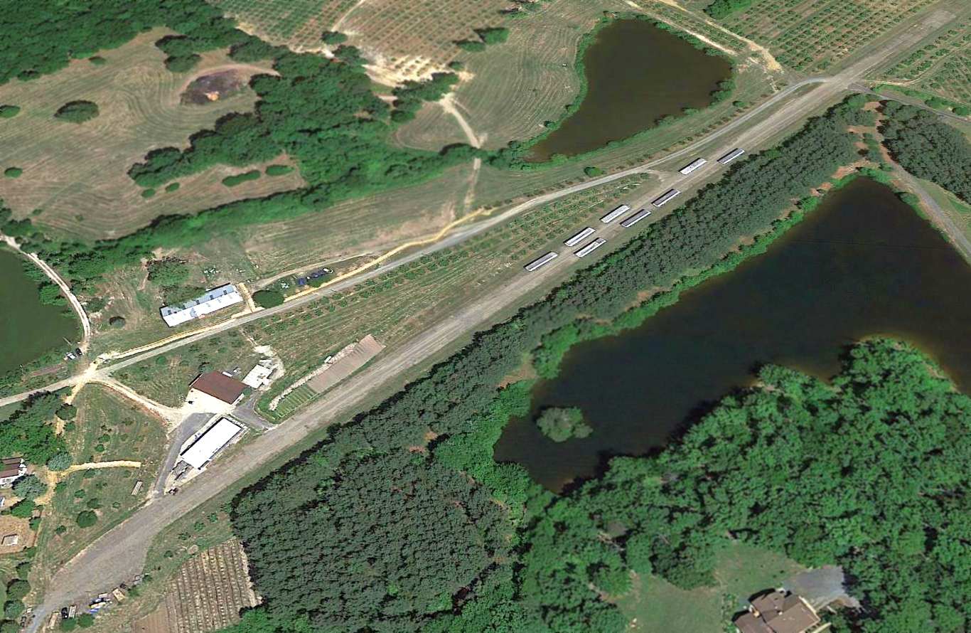
A 2015 aerial view looking north depicted Flying T Farm Airfield as having several trailers parked along its runway.
Andy Tyler reported in 2016, “The place was sold twice since & the farm is used as an orchard, and the former strip, although in fairly good condition, now is used to park trailers & equipment.
I miss it incredibly but things happen & change is inevitable.
Every time I visit what's left of the farm I look over the fence with endless memories & thinking of how great it would be to land my RV at the old homestead.”
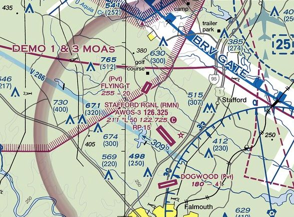
Flying T Farm Airfield continues to be depicted on the 2016 Washington Terminal Aeronautical Chart.
This is really a safety hazard for this airfield to continue to be depicted on aeronautical charts, given that it has not been used for flying in years, and instead has trailers parked along its runway.
Flying T Farm Airfield is located southwest of the intersection of Ramoth Church Road & Courthouse Road.
Thanks to Andy Tyler for pointing out this airfield.
____________________________________________________
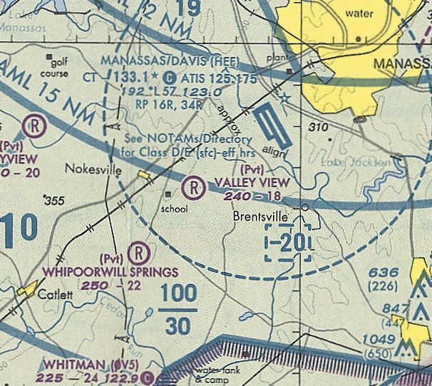
Valley View Airport, Nokesville, VA
38.692, -77.552 (Southwest of Washington, DC)
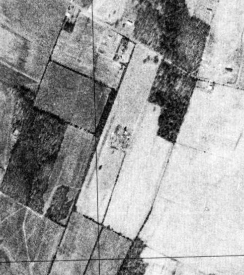
Valley View Airport, as depicted on a 3/9/77 USGS aerial photo.
Not much is known about this apparent former private airfield, other than its name.
The earliest depiction which has been located of Valley View Airport was on a 3/9/77 USGS aerial view,
which depicted a single unpaved northeast/southwest runway, with a cluster of small buildings on the east side.
Valley View Airport was not depicted at all on USGS topo maps from the 1970s through 2015,
nor on the September 1972 Washington Terminal Aeronautical Chart (courtesy of Carl Buick).
The earliest aeronautical chart depiction which has been located of Valley View Airport was on the September 1981 Washington Terminal Chart (courtesy of Ron Plante).
It depicted Valley View as a private airfield having an 1,800' unpaved runway.
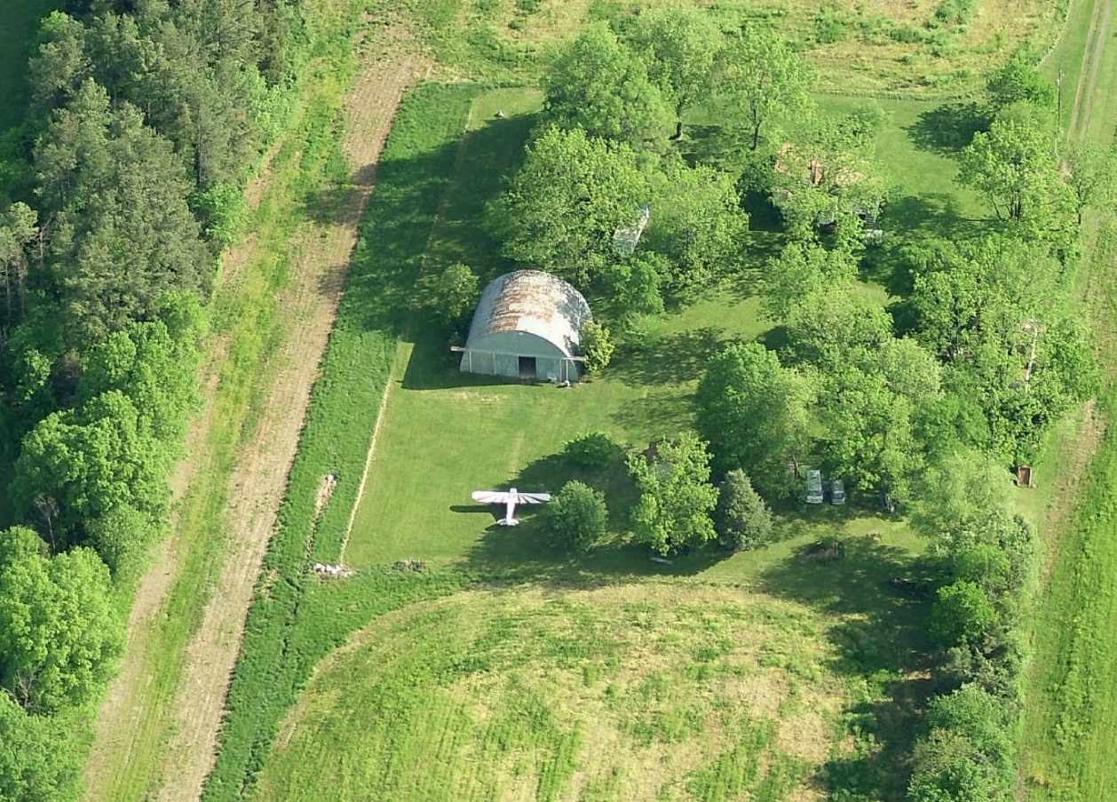
The earliest photo which has been located showing an aircraft at Valley View Airport was a 1989 aerial view looking south (courtesy of Mike Denja).
It depicted 4 light single-engine aircraft parked around the Quonset-hut hangar next to the grass runway.
A 1994 USGS aerial view looking northwest depicted Valley View Airport as having 1 light single-engine aircraft parked north of the hangar.
 0
0
The last aeronautical chart depiction which has been located of Valley View Airport was on the February 2001 Washington Terminal Chart (courtesy of Ron Plante).
It depicted Valley View as a private airfield having an 1,800' unpaved runway.
A 2002 aerial photo showed the 1 aircraft remained parked on the north side of the hangar.
A 2003 aerial photo showed the aircraft had been moved to the south side of the hangar,
a position in which it remained in aerial photos for the next 12 years.
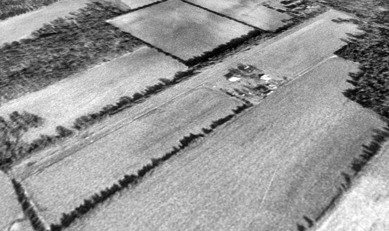
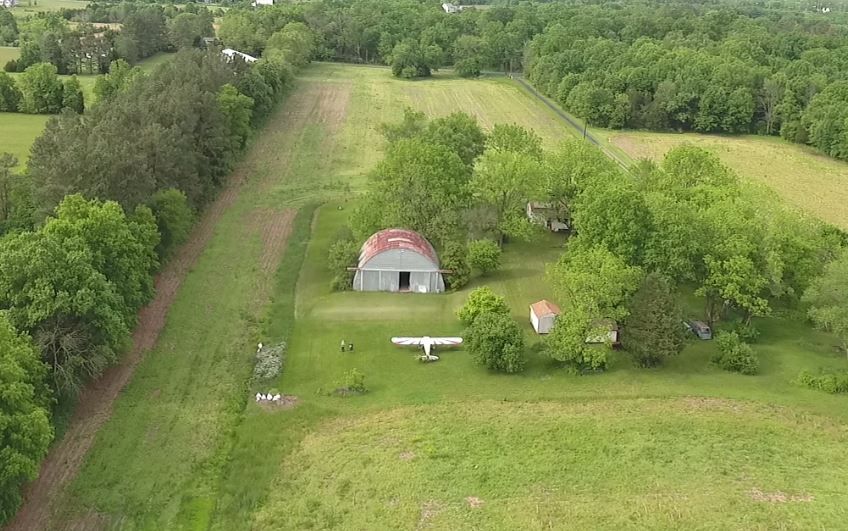
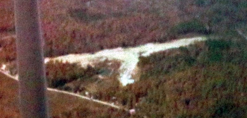
A circa 2010 aerial view looking north showed the Valley View Airport Quonset hut hangar,
with 1 light single-engine taildragger parked to the south.
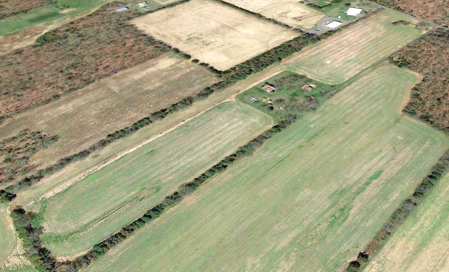
A 2015 aerial view looking northwest showed the Valley View Airport runway remained clear,
and the single-engine aircraft remarked parked in the same spot, on the south side of the hangar.
As of 2015, Valley View Airport was not registered with the FAA, but it was still depicted on street maps.
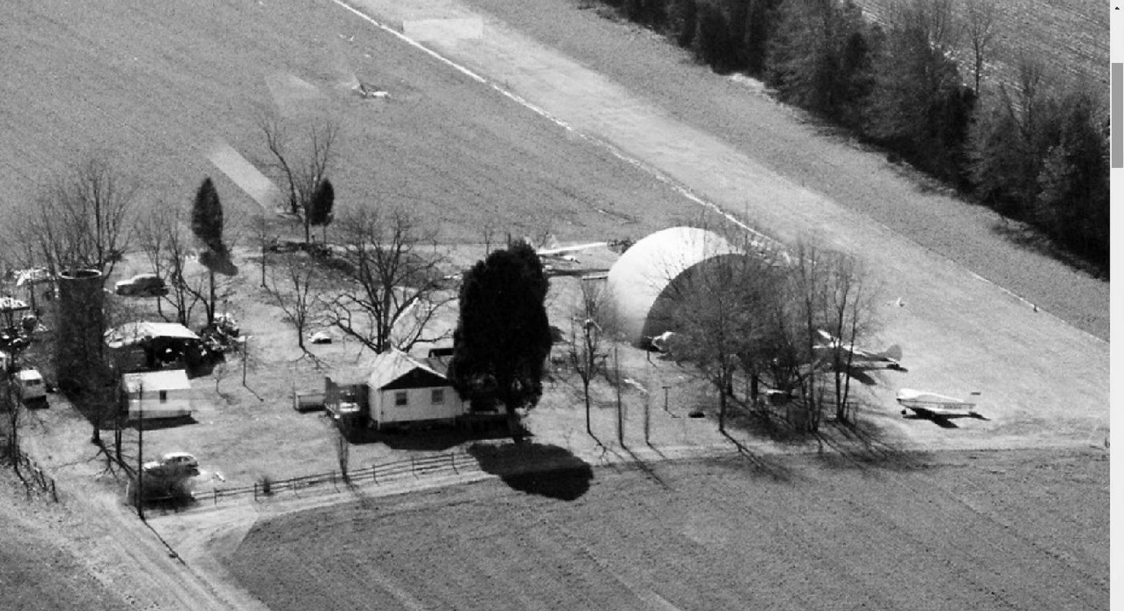
A 5/20/16 aerial view by David Cuff looking north at Valley View Airport, taken from a drone aircraft.
David reported, “I went to Valley View Airport & shot a video of it with a drone.
I talked to the guy who started it on the phone the other day; he's 92 & lives in Florida.
The airplane that has been sitting there for years belonged to a friend of his who passed away.
The logbooks have been lost or are not complete so it can't fly again apparently. It looks all complete.
There's a nice little plane in the hangar. The one outside is a 1946 Cessna 140, N76783.”
A 5/20/16 aerial view by David Cuff looking south at Valley View Airport, taken from a drone aircraft.
Valley View Airport is located southwest of the intersection of Colvin Lane & Arden Road.
Thanks to David Cuff for pointing out this airfield.
____________________________________________________
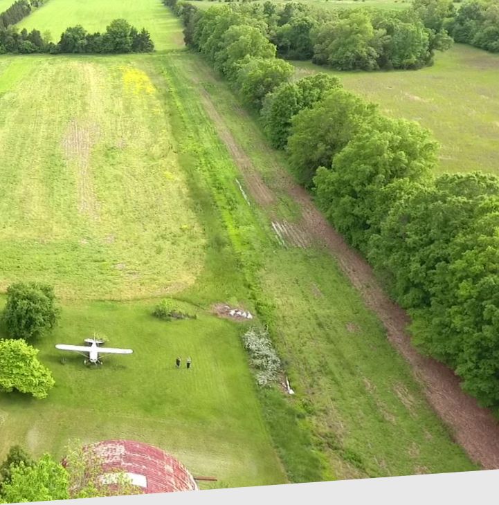
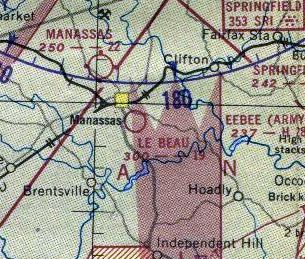
Libeau Airport / Le Beau Airport, Manassas, VA
38.738, -77.458 (Southwest of Washington, DC)
Le Beau Airport, as depicted on the July 1949 Washington Sectional Chart.
According to the 2003 book "Virginia Airports" by Vera Rollo & Norman Crabill (published by the VAHS),
Donald Libeau established an 1,850' private turf field during WW2 on Libeau family land.
Libeau Airport was not yet depicted on the April 1948 Washington Sectional Chart.
Strangely, aeronautical charts & topo maps misspelled the name as Le Beau.
The July 1949 Washington Sectional Chart depicted Le Beau Airport as having a 1,900' unpaved runway.
A 1949 aerial photo depicted Libeau Airport as having a single unpaved northwest/southeast runway.
Two single-engine planes were visible next to a small building on the northeast side of the runway.
The 1951 Washington Sectional Chart depicted Le Beau Airport as having a 1,900' unpaved runway.
A 1952 aerial photo depicted 2 single-engine planes next to a small building on the northeast side of Libeau Airport.
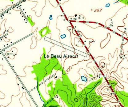
The 1956 USGS topo map depicted Le Beau Airport as having a northwest/southeast runway.
The last depiction which has been located of Le Beau Airport was on the 1956 Washington Local Aeronautical Chart (courtesy of Tim Zukas).
It depicted Le Beau Airport as having a mere 1,800' unpaved runway.
According to the book "Virginia Airports", Libeau Airport closed in 1960 when the property was sold.
A 1962 aerial photo showed that Libeau Airport was still intact, but there were no aircraft visible on the field.
A 1963 aerial photo showed no change in the configuration of Libeau Airport.
A 1964 aerial photo appeared to show that the building on the northeast side of Libeau Airport had been removed.
Libeau Airport was no longer depicted on the September 1972 Washington Terminal Chart (courtesy of Carl Buick).
Chris Libeau reported that his grandfather operated Libeau Airfield.
He recalled, “My uncle, Donald Libeau, built his home on some of the land that was part of the airfield.
I heard mention of the airfield & I used to play around in the old hangar.”
A 1981 aerial photo showed that the site of Libeau Airport remained clear.
A 1994 aerial photo showed that houses had been built over the site of Libeau Airport.
A 2012 aerial photo showed no trace of Lebeau Airport.
The site of Libeau Airport is located west of the intersection of Lake Jackson Drive & Libeau Drive, appropriately enough.
Thanks to David Cuff for pointing out this airfield.
____________________________________________________
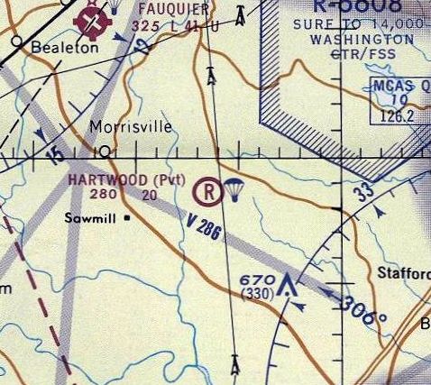
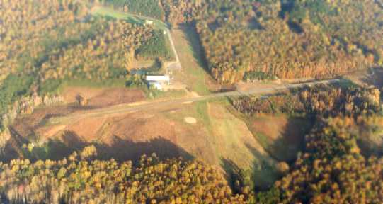
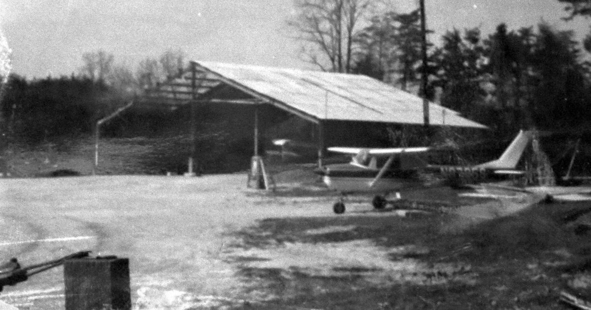
Hartwood Airport (8W8, 3VG7), Hartwood, VA
38.484, -77.612 (Southwest of Washington, DC)
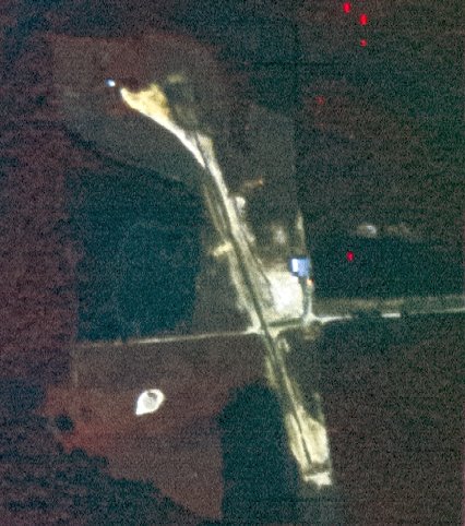
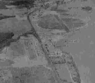
Hartwood Airport, as depicted on a 9/25/70 USGS aerial view.
Yet another small general aviation airport in Northern Virginia lost to more-lucrative land uses.
Hartwood Airport was not yet depicted on a 1952 aerial photo
or the February 1961 Washington Local Aeronautical Chart (courtesy of Scott Kimball).
According to an article in the 3/8/10 issue of the Fredericksburg News,
Hartwood Airport opened in 1969, and was once a base for skydivers.
The earliest depiction which has been located of Hartwood Airport was on a 9/25/70 USGS aerial view.
It depicted Hartwood as having 2 unpaved runways & a hangar on the northeast side.
The Skydive Hartwood logo.
According to the Skydive Hartwood website, “Hartwood Paracenter is a well equipped private facility
located on over 180 beautiful acres only 50 miles south of Washington D.C.
In operation since 1969, Hartwood boasts one of the highest safety records in the industry.
We offer state of the art equipment, comprehensive training, licensed instructors & great facilities for both new & experienced jumpers.
Our experienced staff includes coaches for beginners as well as organizers for group & team Relative Work.
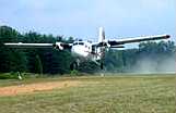
Hartwood owns & operates a DeHavilland Twin Otter & a Cessna 206.”
The earliest aeronautical chart depiction which has been located of Hartwood Airport
was on the 1971 Washington Sectional Chart (courtesy of Ed Francis).
It depicted Hartwood as a private airfield having a 2,000' unpaved runway, conducting parachute operations.
Hartwood Airport was not yet depicted on the 1972 USGS topo map.

The September 1972 Washington Terminal Aeronautical Chart (courtesy of Carl Buick) depicted Hartwood as a public-use airport with a 2,000' unpaved runway.
The 1975 Washington Terminal Aeronautical Chart (courtesy of Ed Drury)
depicted Hartwood as a public-use airport with a 1,900' unpaved runway, conducting parachute operations.
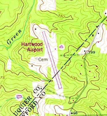
The earliest topo map depiction which has been located of Hartwood Airport was on the 1978 USGS topo map.
It depicted Hartwood Airport as having a single paved northwest/southeast runway, with a single small building on the east side.
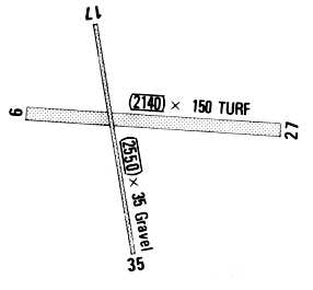
A 1988 airport directory depicted Hartwood Airport as having a 2,550' gravel Runway 17/35 & a 2,140' turf Runway 9/27.
The airport was said to conduct parachute jumping daily, and to have ultralight & glider activity.
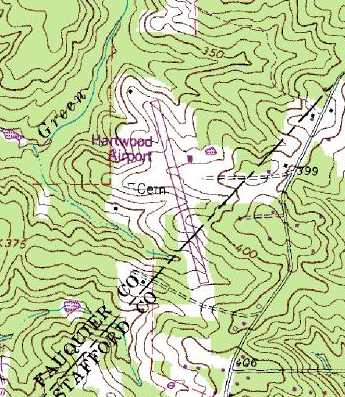
The 1989 USGS topo map depicted Hartwood Airport as having a single paved northwest/southeast runway,
with a single small building on the east side.
An October 1992 aerial view looking east depicted Hartwood Airport to have 2 perpendicular runways, with a hangar on the northeast side.
An undated photo presumably of the Skydive Hartwood Twin Otter at Hartwood Airport.
A 4/2/94 USGS aerial view depicted Hartwood as having a paved northwest/southeast runway,
an unpaved east/west runway, 2 small hangars northeast of the runway intersection,
and 4 light aircraft on the southwest & northeast sides.
The 1998 VA Airport Directory depicted Hartwood Airport as having a 2,470' turf-gravel Runway 17/35 & a 2,000' turf Runway 9/27,
with 2 hangars on the northeast side.
The operator was listed as Hartwood Aviation, and the manager was listed as H.C. Schoelpple.
According to the 2003 book "Virginia Airports" by Vera Rollo & Norman Crabill (published by the VAHS),
Hartwood Airport had 2 turf runways: 2,470' Runway 17/35 & 2,000' Runway 9/27, and parachute jumping.
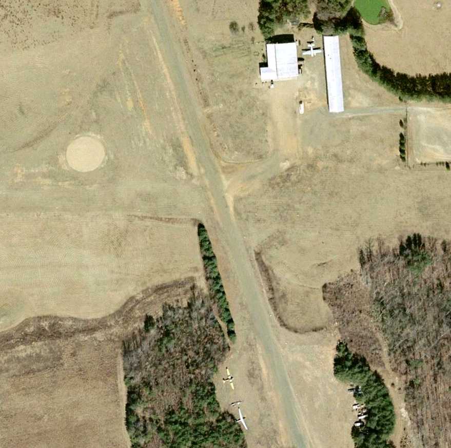
A 1/1/02 aerial view showed 3 aircraft at Hartwood Airport: 2 gliders on the southwest side, and 1 single-engine aircraft next to the hangar.
The airfield facilities appeared unchanged from the 1994 view.
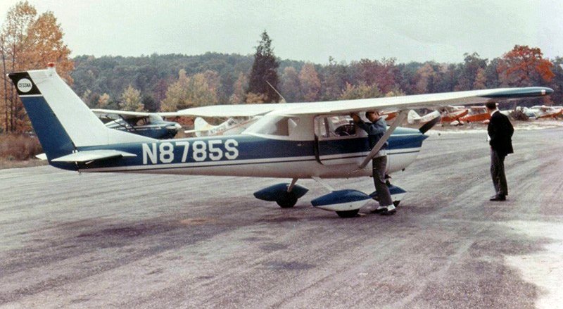
Joe Goodin recalled, “Hartwood Airport... I landed there in a C172 & C182 a few times when it was open.”
Stewart recalled, “Hartwood Field, on 7/27/03, a parachute & gliding center, the site was closed but the following were visible:
N5261G: Cessna 305 Bird Dog, derelict, no wings, on an [equally] derelict trailer. Evidence of front-end damage. Had not moved since previous visit 3 years ago.
N171S: Twin Bonanza, one engine missing. Had not been worked on since last visit 3 years ago.
N1174S: Schweizer SGS-2, resident. The small hangar contained 1-2 aircraft but was inaccessible.”
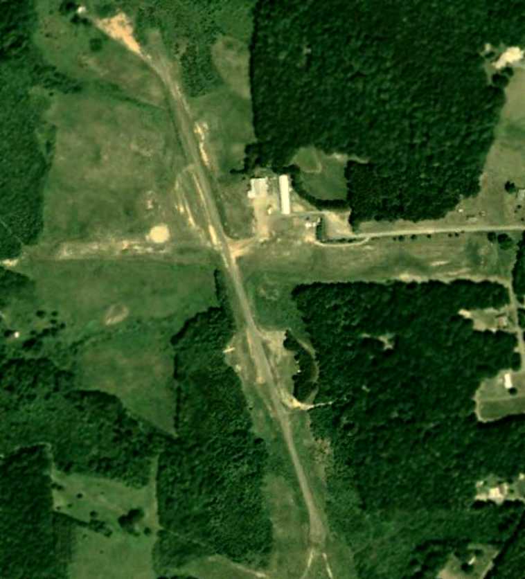
The last photo which has been located showing Hartwood Airport before its redevelopment was a 5/23/06 aerial view.
Only a single aircraft (possibly a glider) was visible on the southwest side of the field.
An article entitled “Hartwood Airport now test area” appeared in the 3/8/10 issue of the Fredericksburg News:
“Planes do not land at Hartwood Airport in Stafford County these days.
The runway looks more like a roadway now, and a toll booth sits on the former taxiway.
It is now a 'test lane' facility operated by Unisys Corp. & the U.S. Customs & Border Protection Agency.
It is home to a simulated international border crossing where technology akin to an E-ZPass is being evaluated for use at border crossings.
The facility just happens to straddle something of a border - the line between Fauquier & Stafford counties off Cropp Road -
and has been operating on the Fauquier side for 3 years.
Unisys plans to expand its operation into Stafford.
The property is zoned for agricultural use in Stafford, which did not allow this sort of use by right or by conditional-use permit.
In a joint public hearing last Tuesday night, the Stafford Planning Commission & Board of Supervisors
unanimously approved a zoning ordinance text amendment & a conditional-use permit
so Customs & Border Protection can expand the test-lane facility at the airport.
Hartwood District Supervisor Gary Snellings said that the permit was written narrowly to allow only this particular use.”
The article continued, “Fauquier officials passed a similar permit in February for the expansion.
Unisys would like to begin construction immediately, so the permit process was expedited in both counties.
Stafford staff recommended approval of the conditional-use permit.
Planning & Zoning Administrator Jeff Harvey said the new use will likely be less intensive than the airport was.”
Note that this is a particular spurious assertion,
as this little grass-runway country airport certainly never had tractor-trailers operating on the property.
The article continued, “According to documents provided to the county,
the site is designed as a full-scale mock-up of a Mexico-U.S. border crossing & is part of an effort to combat drug trafficking in the Southwest.”
"It's very low-key," Snellings said. "It's been there for 3 years & I've never heard anyone complain about it."
Randall Burdette reported in 2010, “Hartwood was a privately-owned public-use airport.
It had numerous problems with obstructions around the airport.
Even though the state (VA) pays 80% of costs to remove the trees,
it can sometimes be costly for an airport owner to maintain a safe operating environment.
When the airport owner was approached with a lucrative offer for a short-term lease,
it gave them some options for a cash influx.
The airport was closed at the owner's request.”
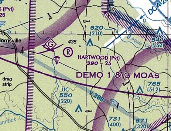
The July 2010 Washington Terminal Aeronautical Chart depicted Hartwood as a private airfield having a 2,500' unpaved runway,
and conducting glider & parachute operations.
Note that Hartwood's depiction as a charted airport on a July 2010 aeronautical chart would appear to be contradicted by the March 2010 article
which claims the airport has been defunct since 2007.
Randall Burdette reported in 2010, “We have submitted Hartwood Airport to be removed from the FAA charts on several occasions.
Hopefully this will be the year it comes off the charts.”
Joe Goodin reported in 2017, “Hartwood Airport... A few months ago, one of the doors to the long narrow hangar was open
and an old AgCat style plane was half-out of the hangar & a guy was wrenching on it.
I struck up a conversation with him & found out that he still flies his plane out of what is left of the east/west turf runway adjacent to the access road.
He doesn't use the plane for crop dusting any more, just pleasure flying.”
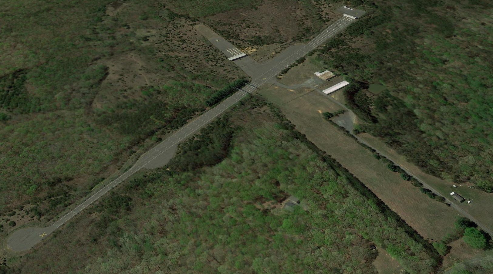
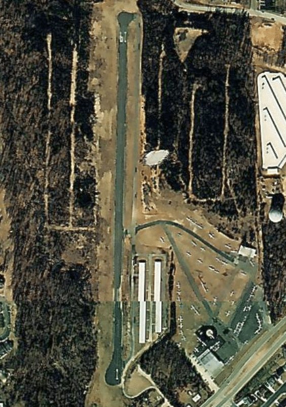
A 2018 aerial view looking northwest at Hartwood Airport shows what has become of this former little country airport – now a border security test site.
Most of the runways have been paved over, but the 2 former hangars remain standing.
The site of Hartwood Airport is located west of the intersection of Dophie Road & Cropp Road.
____________________________________________________
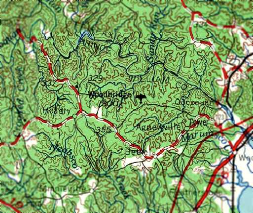
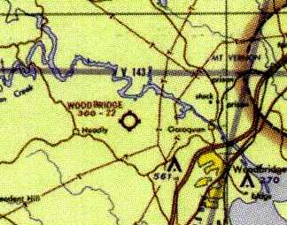
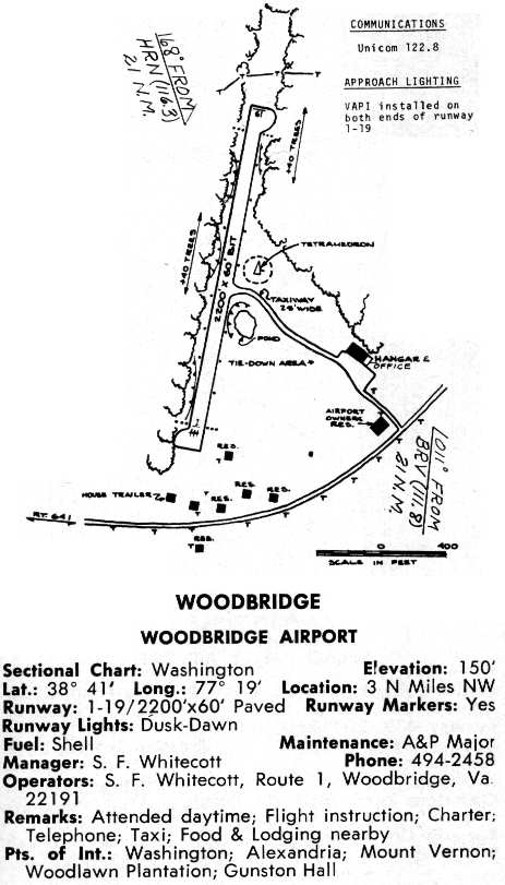
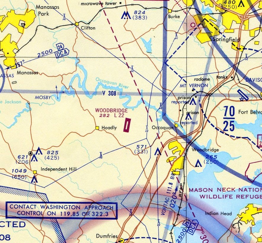
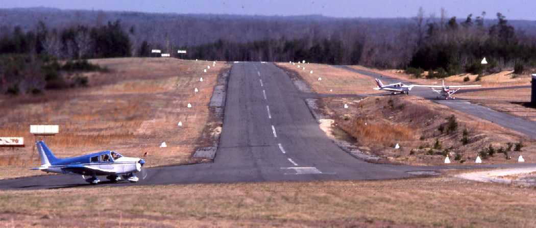
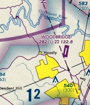
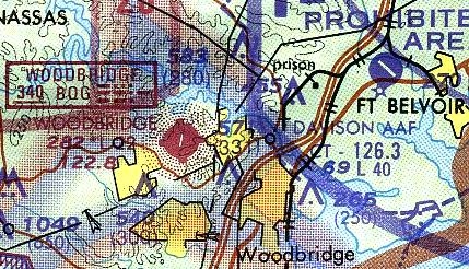
Woodbridge Airport (W22), Woodbridge VA
38.685, -77.32 (Southwest of Fort Belvior, VA)
A 1962 aerial view depicted the Woodbridge Airport as little more than a dirt clearing.
No aircraft, hangars, or other improvements were discernible.
Nothing was yet depicted at the site of the Woodbridge Airport on the 1957 USGS topo map.
According to an article by David Cuff on historicprincewilliam.com (courtesy of Arquimides Cintron),
“In 1959 Steve Whitecoff bulldozed a straight, but not flat section of property behind his house on what then was called the Old Woodbridge Road.
The airport was built in a time when personal aviation was taking off. Thanks to few regulations & pilots returning home after WW2, flying had taken off in the country.”
Woodbridge Airport was not depicted on the 1961 Washington Local Aeronautical Chart (courtesy of Mike Keefe).
The earliest official reference to Woodbridge Airport which has been located was in the 1962 AOPA Airport Directory,
which described Woodbridge as having a single 2,200' dirt runway.
The earliest depiction which has been located of the Woodbridge Airport was a 1962 aerial view.
It depicted the Woodbridge Airport as little more than a north/south dirt clearing. No aircraft, hangars, or other improvements were discernible.
A circa 1960s aerial view looking northwest depicted Woodbridge Airport as a snowy north/south clearing.
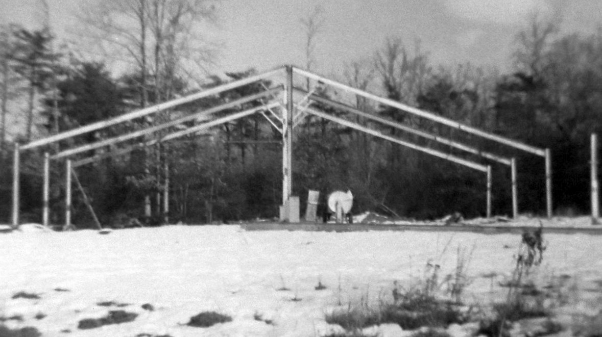
A January 1963 photo showed Woodbridge Airport's Hangar 1 under construction.
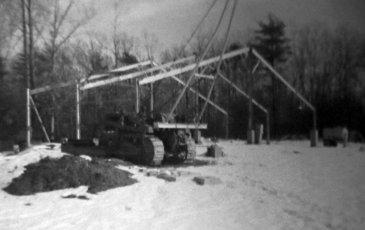
A January 1963 photo showed Woodbridge Airport's Hangar 2 under construction.
A 1963 aerial view showed that 3 light single-engine aircraft were parked on the east side of Woodbridge Airport.
Woodbridge Airport, as depicted on the 1963 USGS topo map.
The earliest aeronautical chart depiction which has been located of the Woodbridge Airport
was on the 1963 Washington Local Aeronautical Chart (courtesy of Mike Keefe).
It described Woodbridge as having a single 2,200' bare runway.
A 1964 aerial view showed that 2 small buildings had been added at some point in the previous year on the east side of the field.
Three light single-engine aircraft were parked on the east side of the field.
The September 1965 Washington Local Visual Navigation Chart
described Woodbridge as having a single 2,200' bare runway.
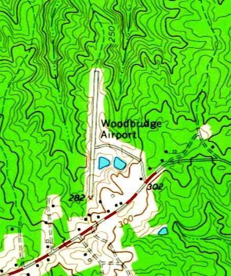
The 1966 USGS topo map depicted Woodbridge Airport as having a single paved north/south runway,
with a few small buildings on the south side.
Note how undeveloped the surrounding area was.
By 1966, the runway had been paved, as the 1966 VA Airport Directory (courtesy of Stephen Mahaley)
depicted Woodbridge as having a 2,200' bituminous Runway 1/19.
The tie-down area was southeast of the runway, and a taxiway led from the middle of the runway to a ramp with a hangar & office along the east side.
A circa late-1960s aerial view from final approach to Runway 19 showed Woodbridge Airport as having a paved Runway 1/19, with light planes parked on the east side,
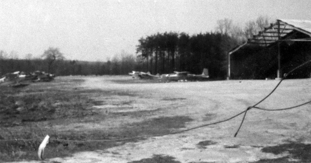
A circa 1960s photo of light planes & a hangar at Woodbridge Airport.
Christian Roberts recalled, “I learned to fly out of W22 in June 1967 using a Cessna150 that the Whitecotts owned.
They has just finished paving the runway.
My Uncle, who was sponsoring me, drove me around to what seems every small airport in VA & deemed W22 as the toughest one he could find,
especially with that dip at the end of the runway.
He said 'You learn to fly & land here, you can land anywhere.' He was right!
After a while landing there was a breeze.”
The airfield configuration at Woodbridge Airport was still the same in the 1968 Virginia Airport Directory (courtesy of Don Thompson).
It listed the operator as S.F. Whitecott.
Jim Lane recalled, “On 6/23/70 I was ferrying a customer's Mooney M-20F N9717M
from Gaithersburg, MD back to my home base Richmond Aviation at Richmond International Airport for maintenance.
Abeam of Woodbridge at 5,000' the airplane suffered a sudden catastrophic engine failure (broken crankshaft).
Fortunately as a current Mooney instructor I was able to make a power-off forced landing at Woodbridge.”
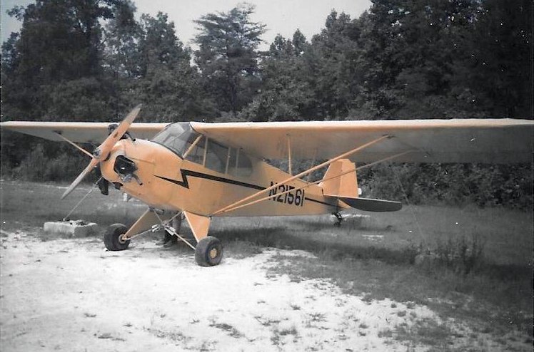
A 1970 photo of a 1938 Piper J3P Cub at a snowy Woodbridge Airport.
According to an article by David Cuff on historicprincewilliam.com (courtesy of Arquimides Cintron),
“Woodbridge Airport continued to survive among the residential development.
The Whitecoff family sold the airport in 1970 to Charles Benn, an Army Air Force veteran who had operated the Washington-Virginia Airport.”
Ned Swartz recalled, “Woodbridge Airport... where I worked for Charles Benn in 1970-71 on weekends,
answering Unicom, writing up tickets for fueling, sometimes helping to tie down planes
and often going with Mr. Benn on a quick air-trip to retrieve a part, deliver a charter, etc.
He was of the Benn family that owned & operated the Washington-Virginia Airport at Bailey’s Crossroads,
and he bought the Woodbridge Airport when that one closed in the late 1960s.
I worked at the Woodbridge Airport on a part-time basis to earn a little extra money for flying
(but more importantly to be around airplanes).
Mr. Benn would let me fly some of his fleet at a good discount
and with lots of free “instruction,” mostly verbal, but occasionally with him as my instructor.”
Ned continued, “I always enjoyed the challenge of flying into & out of Woodbridge.
I remember 1 or 2 storms hitting the airport, which on one occasion literally ripped the wings from a plane
made famous by one of the 'around-the-world' trips for single engine airplanes.
I also remember the several accidents that happened because of the steep & unusual approaches needed for the Woodbridge airport,
and the 'dip' in the south end of the runway.”
The September 1972 Washington Terminal Chart (courtesy of Carl Buick) depicted Woodbridge Airport as having a 2,200' paved runway.
A circa 1970s photo of a Cessna 150 in front of a Woodbridge Airport hangar.
A circa 1970s photo of a Cessna 150 & other light planes at Woodbridge Airport.
Stephen Mahaley (who had a friend whose father had a plane at Woodbridge) recalled
"In later years there was a parallel taxiway & a much bigger ramp, with a larger hangar at the south end of the ramp.
One unusual feature of the airport is that the runway elevation was about 25' below the ramp.
The western end of the taxiway (just before the runway) had a very steep section.
Care had to be taken going down the hill, and it took a few seconds of full power to get up the hill.
The runway itself was hardly level, with a big dip in the southern half that continued uphill to the north."
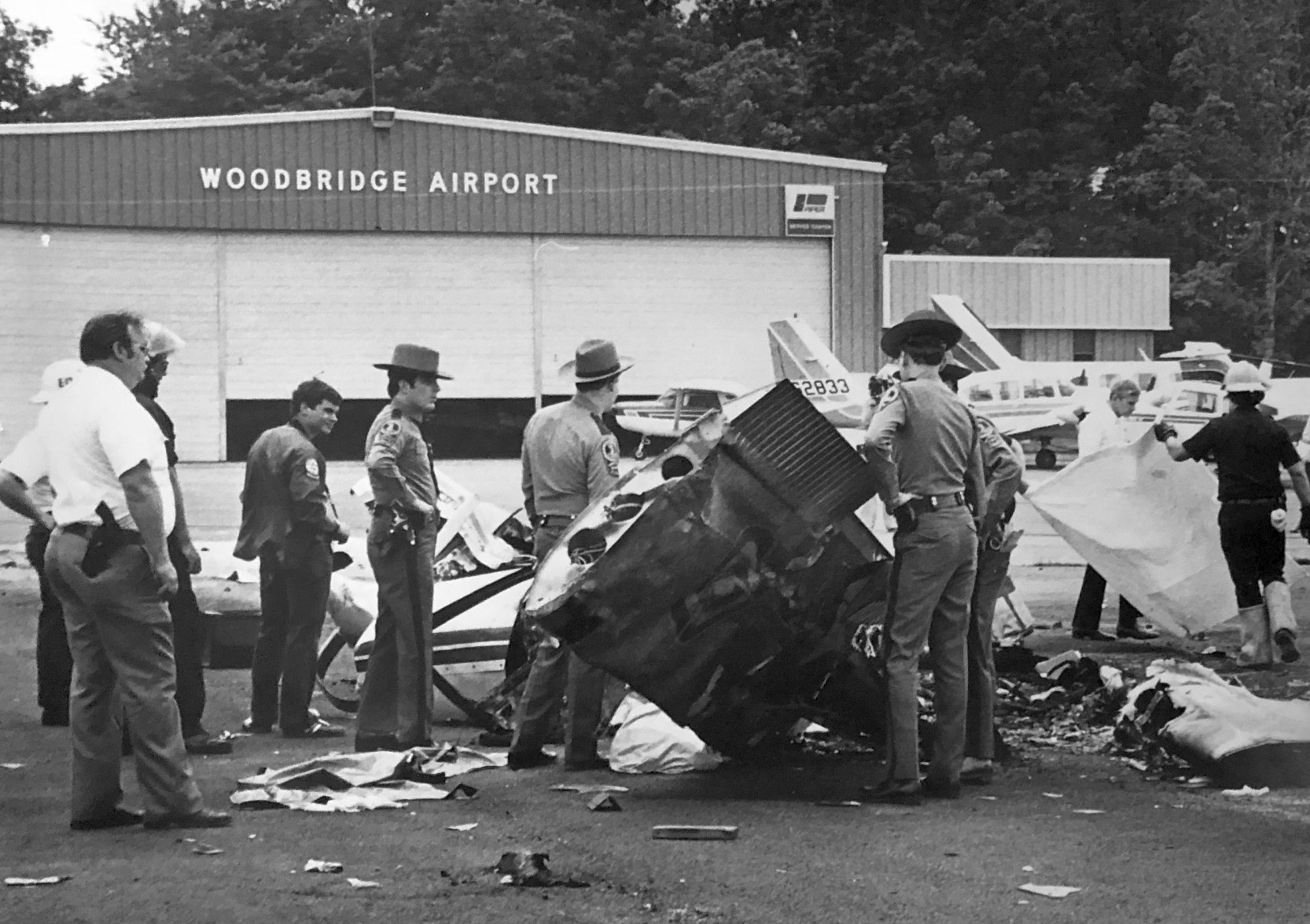
A 1977 photo of police with the wreckage of an aircraft accident in front of a Woodbridge Airport hangar (courtesy of Susan Scaglione).
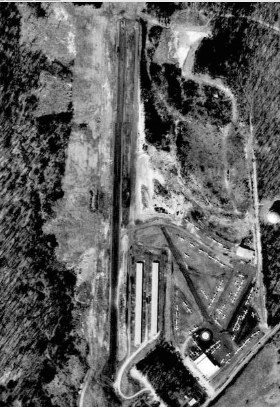
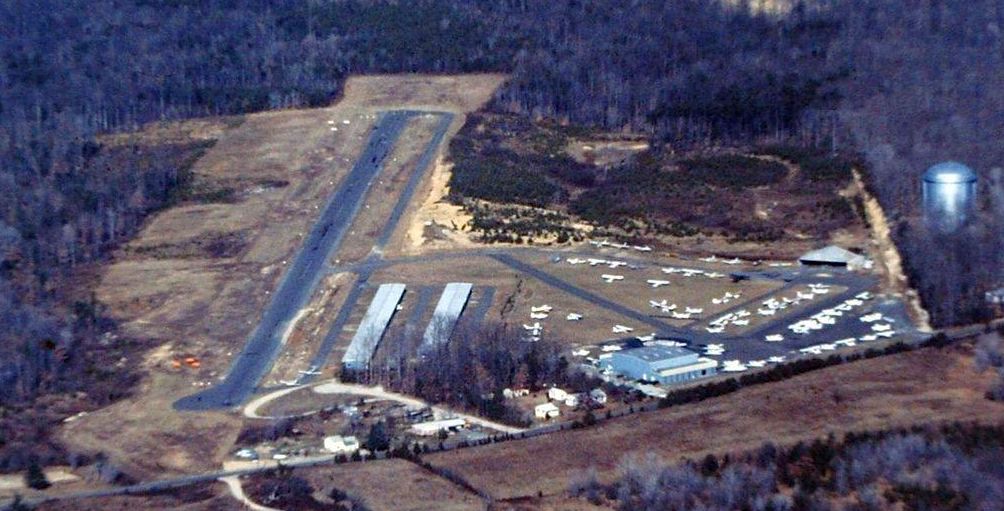
A 1979 aerial view (from the Prince William County Mapper) depicted Woodbridge Airport as a very popular airport, with over 50 light aircraft visible on the field.
A 1980 photo by Charles Kirky looking along Woodbridge's rolling Runway 1, with 2 Pipers & a Cessna prearing for takeoff.
A December 1980 aerial view by Ed Stallknecht (courtesy of Robert Sullivan) looking north at Woodbridge Airport.
According to an article by David Cuff on historicprincewilliam.com (courtesy of Arquimides Cintron),
“In the mid-1970s Ed Stallknecht flew out of the Woodbridge Airport often.
Stallknecht was a local real estate agent who focused on land sales & was known as the 'Flying Realtor'. Stallknecht enjoyed taking pictures.”
The September 1981 Washington Terminal Chart (courtesy of Ron Plante) depicted Woodbridge Airport as having a 2,200' paved runway.
In the 1982 AOPA Airport Directory (courtesy of Ed Drury),
Woodbridge Airport was described as having a single 2,246' asphalt Runway 1/19, and the operator was listed as Woodbridge Airport Inc.
Woodbridge Airport, as depicted on the 1983 Maryland State Aeronautical Chart.
It also depicted that Woodbridge Airport had its own NDB navigational beacon on the field.
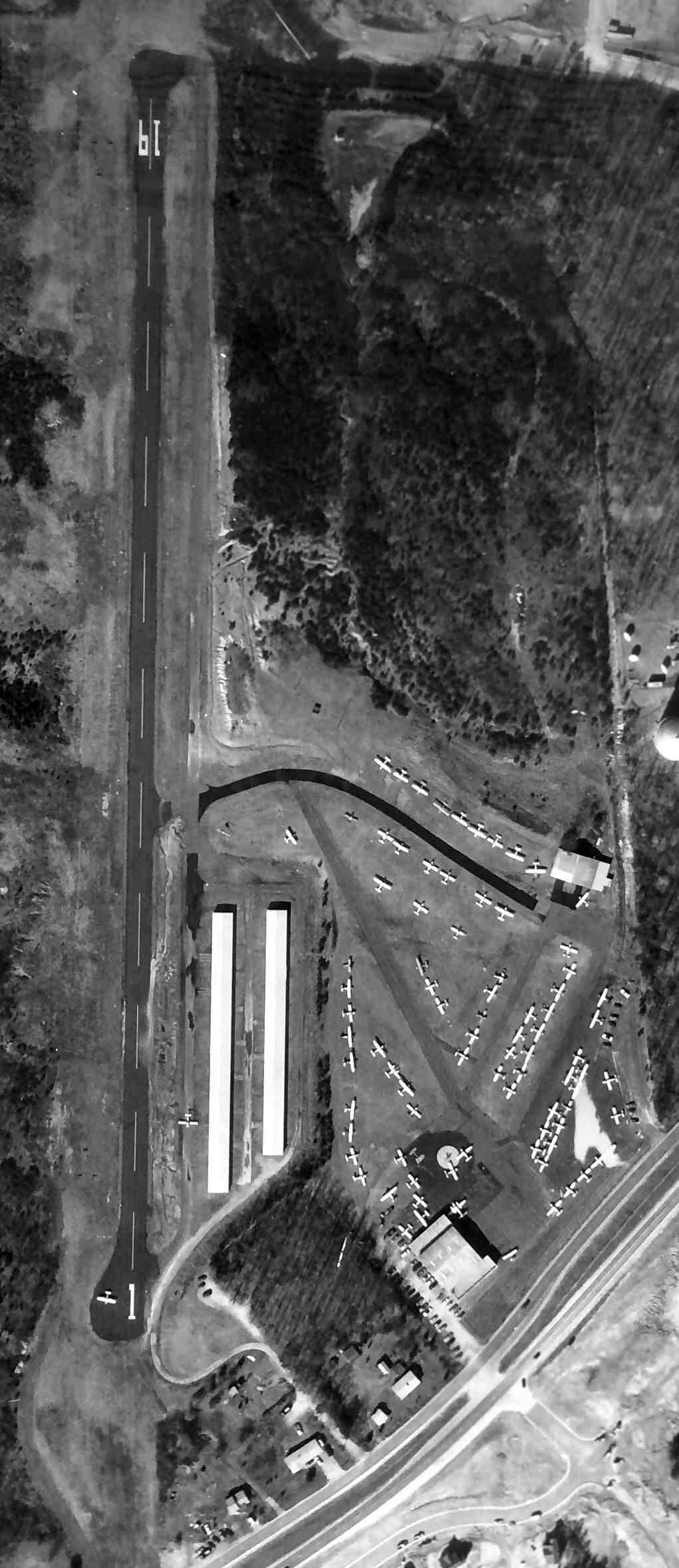
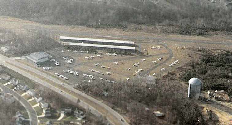
A 1984 aerial view of Woodbridge Airport (courtesy of Ed Eaves via 1984 PWC aerial survey) showed the field as very well-used,
with dozens of light aircraft parked on the southeast side.
The 1984 USGS topo map depicted Woodbridge as having 2 rows of T-hangars along the southeast side of the runway.
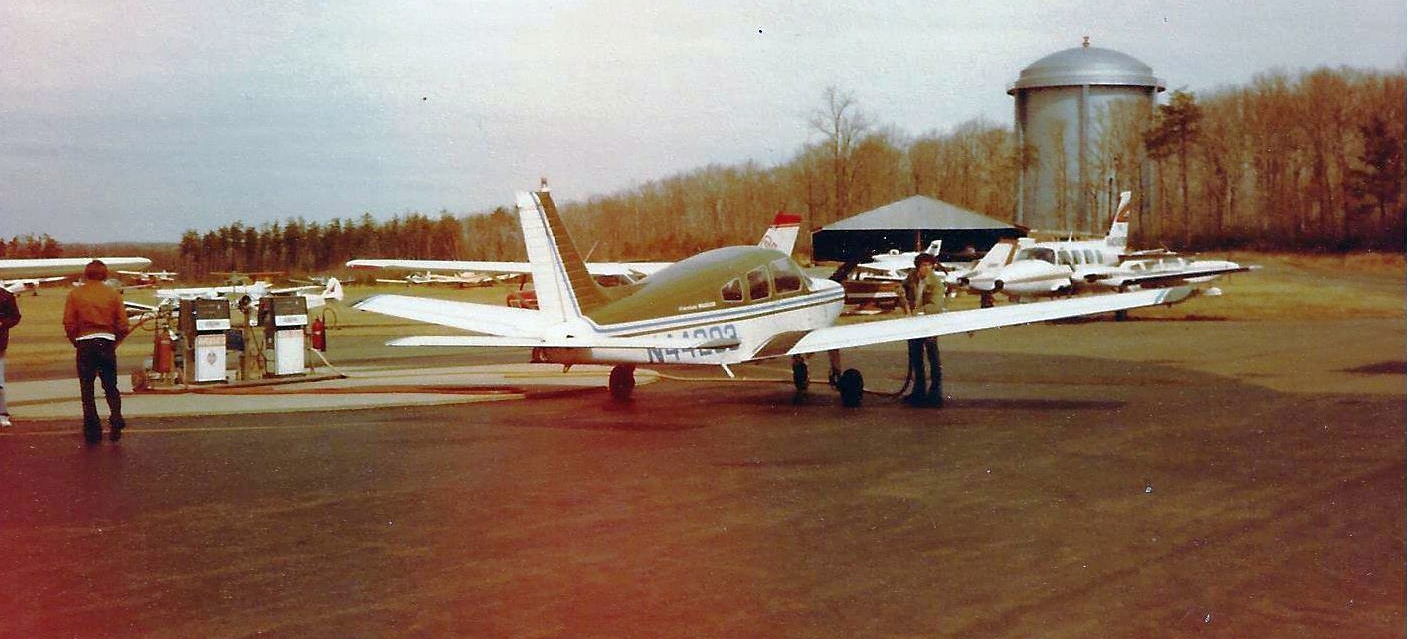
A circa 1984 photo by Frank Fisher of a rental Piper Cherokee being refueled at Woodbridge Airport.
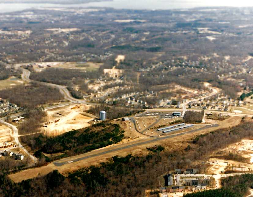
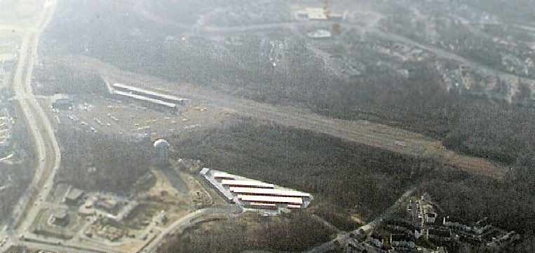
A 3/16/85 aerial view by Kenneth Keeton looking southeast at Woodbridge Airport, showing its proximity to the Potomac River in the background.
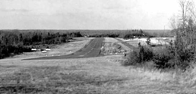
A late-1985 photo by Larry Beaver of Woodbridge Airport, looking north from the shoulder of Old Bridge Road along Runway 1.
A 1986 aerial view by Larry Beaver looking southwest at Woodbridge Airport.
A 1986 aerial photo by Larry Beaver looking southwest at Woodbridge Airport's ramp,
showing several hangars along with dozens of light aircraft.
Larry Beaver recalled, “I learned to fly at W22. My first flight there was on 3/6/86 in a 152 with CFI Don Yoxhiemer.
I stayed in the pattern & did six takeoffs & landings. During my time there I did a little over 140 takeoffs & landings.”
“The airport did have a reputation as being difficult to land & takeoff from.
The runway was only about 50' wide & the dip was quite pronounced.
A friend of mine was learning to fly at nearby Manassas Airport.
His instructor forbade him from landing there [at Woodbridge].
Even after obtaining his PPL he never landed there, even though he lived much closer to Woodbridge than to Manassas.”
“Since I learned to fly there I never saw it as particularly difficult.
I remember that it was a source of amusement for pilots at W22 that others feared to land there.
The reputation of being a difficult airport really was overblown if not undeserved.”
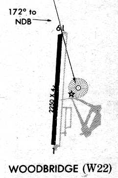
Woodbridge Airport, as depicted on a 1986 NDB-A Approach Plate (courtesy of John Clifford).
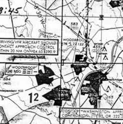
The last aeronautical chart depiction which has been located of Woodbridge Airport was on the March 1987 Washington Sectional Chart.
It depicted Woodbridge as having a single 2,200' paved runway, and an NDB navigational beacon.
The last photo which has been located showing Woodbridge Airport still in operation was a 1987 aerial view (from the Prince William County Mapper).
Ironically, although it showed Woodbridge Airport in its last year, it was perhaps at its zenith of popularity, with over 60 light aircraft visible on the field.
According to an article by David Cuff on historicprincewilliam.com (courtesy of Arquimides Cintron),
“The end for the airport came in 1987 when a commercial development company purchased the property, a year after Charles Benn retired.”
According to the book "Virginia Airports", Woodbridge Airport was closed on 5/31/87, due to rapidly encroaching suburban development.
It's closing was lamented by a nice article in the 6/1/87 issue of the Washington Post.
The article said that 113 aircraft were based at the field during its final year.
Many were expected to relocate to Manassas or Leesburg Airports.
It was said that Woodbridge's tight runway, which was described as being 2,246' long,
with a large dip in the middle & trees at both ends, gave the airport a reputation among pilots for being unforgiving.
"If you could fly in & out of here, you could fly anywhere",
said pilot Hal Blank, who said he bought his home in Lake Ridge to be near the airport & now plans to move.
The article said that "Many of the pilots said that for them, Woodbridge was more than simply a place to park their plane.
They said they often would spend hours in the main hangar, regaling one another with flying stories."
"The sad thing is not so much the airport, it was the people who would come here", said Tom Reich,
an Arlington resident who based his plane at Woodbridge.
The article pointed out that "Between 1974 & last year [1986], more than 1,200 airports closed nationwide,
most of them small, general aviation facilities."
"It's a sad day for general aviation", said Tom Foxworth, a pilot who used to keep his personal plane at Woodbridge.
"You need little airports like this."
Larry Beaver recalled, “I was very disappointed when the airport closed.
I still live in the area & to this day I refuse to shop at the shopping center that replaced it.”
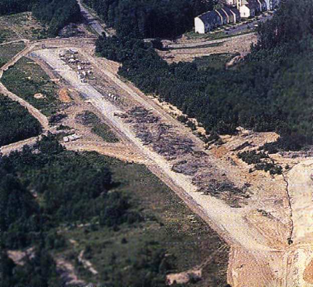
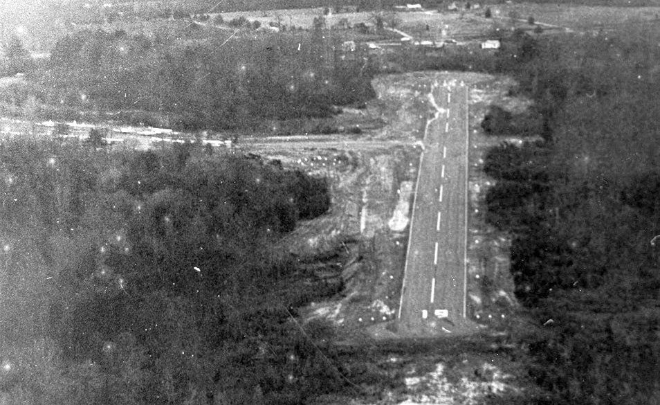
An undated photo of the runway of Woodbridge Airport seen during its demolition.
The cause of its demise is visible in the upper right - new townhouses.
Rick Morgan recalled, "Woodbridge Airport was about 1/4 mile from where I live now -
we moved into the area in '95, apparently just as the last of it was obliterated -
you would never know there had been an airport there now."
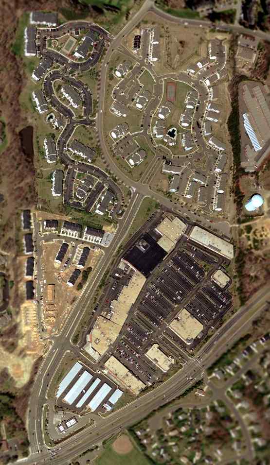
As seen in a 2002 USGS aerial view of the site of Woodbridge Airport,
the southern half of the site had been covered by a shopping center & the northern half was covered by housing.
The water tower which previously held the airport's rotating beacon was still visible on the right edge of the photo.
Larry Beaver reported in 2005, “The water tower is still there today but the beacon was removed a couple of years after the airport closed.”
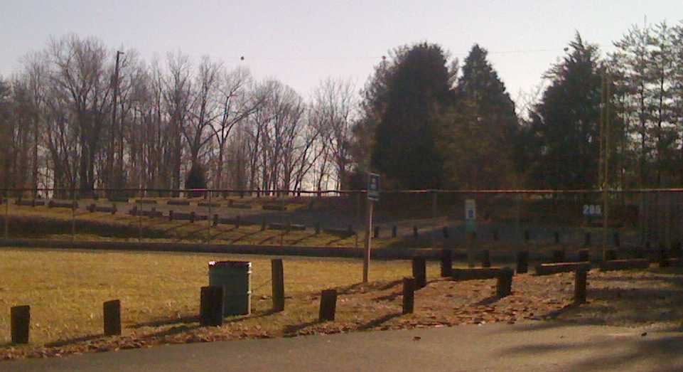
A January 2010 photo by Brent Deen of what was the last trace of Woodbridge Airport.
Brent reported, “I live near the site of the former airfield, and noticed one telltale sign of an airport a few years ago:
orange obstruction marker balls on electrical wires at one end of the old runway.
The runway, of course, is long gone, and 3 of the marker balls were still there, but I recognized them as such immediately.
This wire was on the opposite side of Old Bridge Road, and would have been off the end of Runway 1.”
Brent Deen reported in 2011, “The markers are gone now; the light posts supporting the wires were recently torn down to make way for a Walgreens.”
The Prince William Historical Commission erected a historical plaque in 2019 at the site of Woodbridge Airport.
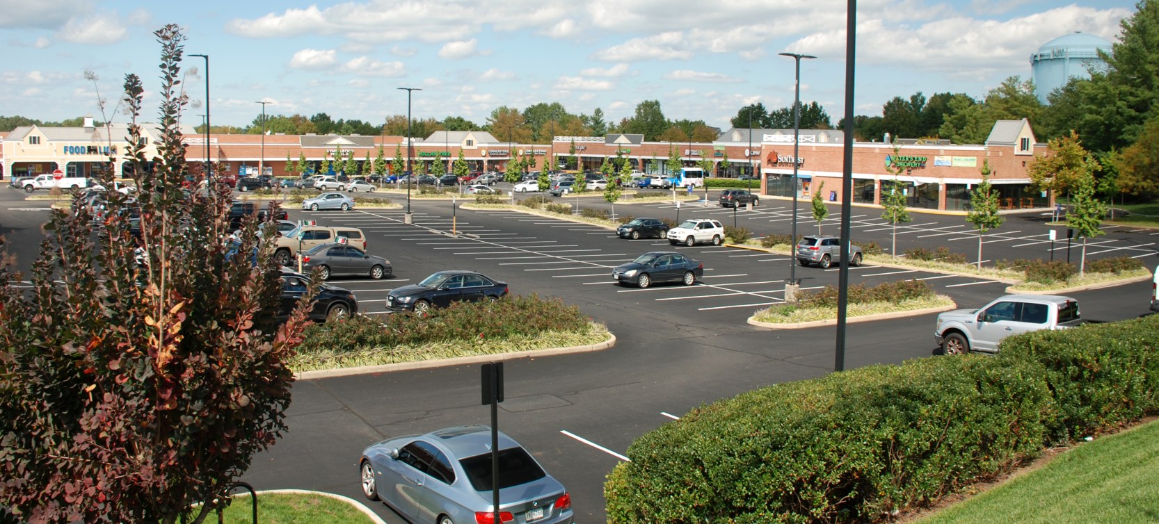
A 9/30/20 photo by Jim Hertsch of the shopping center that occupies most of the site of Woodbridge Airport.
Note the blue water tower in the right background, which was also seen in several pictures of the airport.
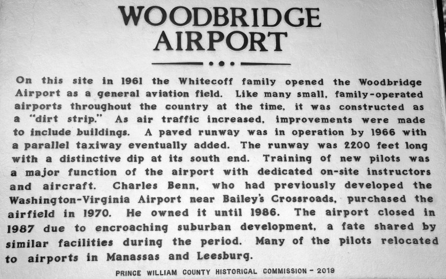
A 9/30/20 photo by Jim Hertsch of the historical plaque erected in 2019 at the site of Woodbridge Airport.
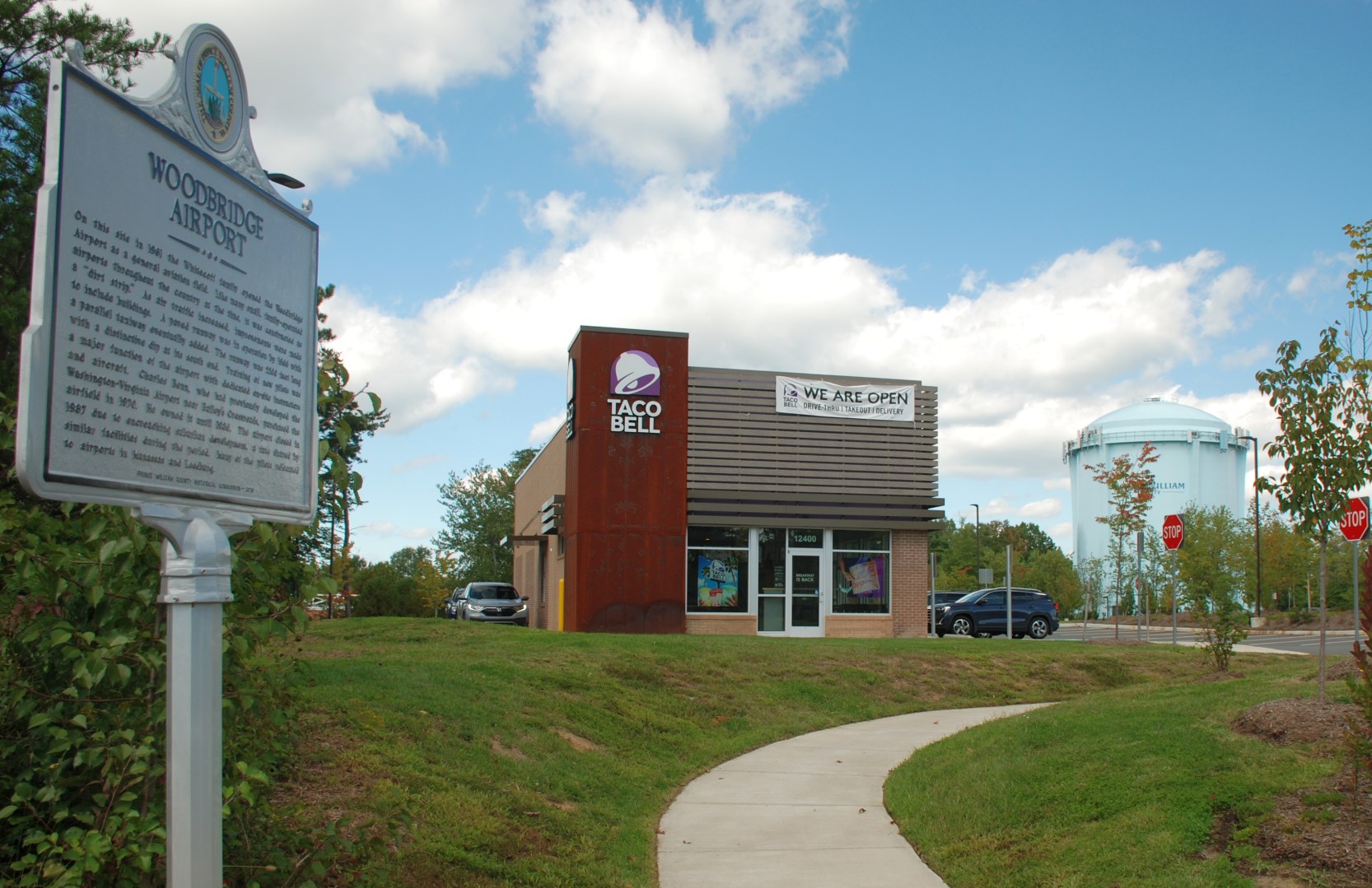
A 9/30/20 photo by Jim Hertsch of the historical plaque & Taco Bell at the site of Woodbridge Airport, and the blue water tower which was also seen in several pictures of the airport.
The site of Woodbridge Airport is located northeast of the intersection of Route 641 & Smoketown Road.
____________________________________________________
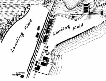
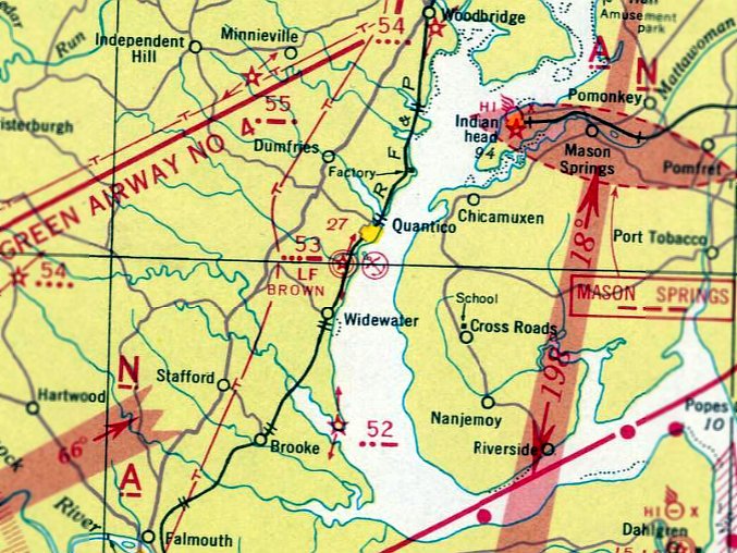
Quantico Marine Corps Air Station Brown Field, Quantico, VA
38.495, -77.315 (South of Washington, DC)
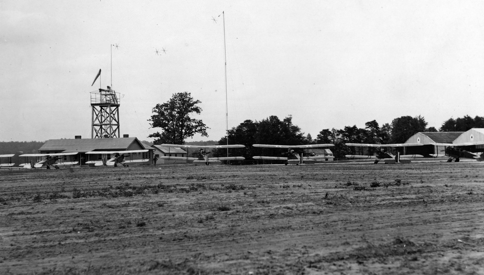
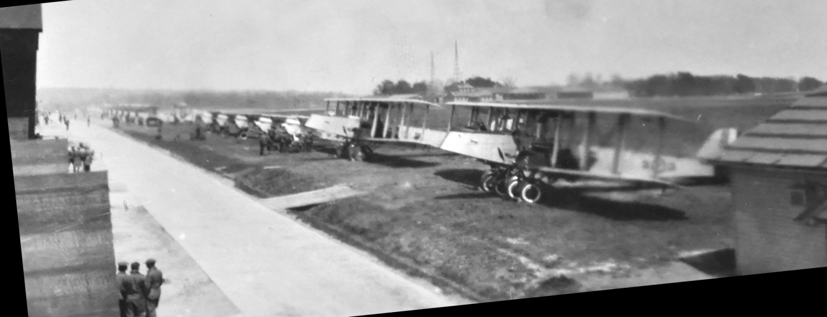
A circa 1922 USMC photo of 7 biplanes, a control tower, hangars, and other buildings at Brown Field.
Marine Corps Base Quantico is well known as the home of Marine Corps aviation,
but it is not well known that the present-day Quantico airfield was actually predated
by not one, but 2 earlier airfields on the base.
Marine Aviation was established at Quantico when a Marine Aeronautical Company was formed in 1918.
The unit initially had 2 kite balloons & 2 free balloons.
They were supplemented later that year by 3 Curtiss R-6 seaplanes & one Curtiss R-9 seaplane.
After WW1, a decision was made to concentrate East Coast Marine Corps aviation units at Quantico.
A parcel of land south of the Chopawamsic Creek was leased in 1919 for the construction of 2 airfields.
Field #1, a 2,000' northeast/southwest strip, was laid out to the east, in between the Potomac River & the railroad tracks.
Field #2, a 2,500' north/south strip, was constructed to the west of the railroad tracks.
Work began on the construction of 3 landplane & 2 seaplane hangars.
Access to the new airfields was complicated by the fact
that vehicular traffic had to take a very roundabout inland route from the airfields to the barracks.
A causeway was eventually built over the creek, providing a more direct route.
By 1920, the aircraft complement at Quantico consisted of the DeHavilland DH-4,
Curtiss JN-4, JN-6, and N-6, plus observation balloons. They were supported by a total of 170 aviation personnel.
In 1921, Quantico Marines conducted an experimental long range flight
from Washington DC to Santo Domino, Dominican Republic & back.
Later that year, several Marines participated in the famous Billy Mitchell bombing raids
on the captured German battleship Osfriesland & other ships off the Virginia coast.
During the return flight, Lieutenant Walter Brown was killed after crashing into the Potomac near the Quantico field.
The next year, the Quantico Fields were renamed Brown Field #1 & Brown Field #2 in his honor.
The earliest photo which has been located of Brown Field was a circa 1922 USMC photo of 7 biplanes, a control tower, hangars, and other buildings.
A 5/1/23 Department of Commerce Aeronautical Bulletin depicted both Brown Field #1 & Brown Field #2,
with several hangars adjacent to both fields.

A circa 1927 USMC photo of an an unidentified man & biplane at Brown Field.
A circa 192s photo of a row of unidentified fighters & 2 larger twin-engine bombers at Brown Field (courtesy of Tom Monroe).
The photo, from an estate sale, was captioned “These are the planes whose motors I overhauled. Taken from the roof of the barracks, Brown Field, VA.”
The earliest aerial photo which has been located of Brown Field was an undated aerial view on the February 1929 V-234 Baltimore-Washington-Norfolk Navy Aviation Chart.
It depicted Brown Field as having 2 grass fields, split by the railroad.
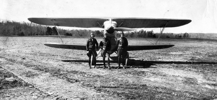
A circa 1929 USMC photo of Lt. Hughes, Brice, and Pugh & a Curtiss Hawk fighter at Brown Field.
The earliest aeronautical chart depiction which has been located of Brown Field was on the February 1929 V-234 Baltimore-Washington-Norfolk Navy Aviation Chart.
In 1930, with new heavier aircraft arriving on the scene,
a project was initiated to replace the small airfields at Quantico
with a new airfield with runways sufficient to operate modern aircraft.
The Chopawamsic Creek was rerouted, eliminating most of the land previous occupied by Brown Field #1,
and land was filled in north of the creek to construct Turner Field (the present-day Quantico Airfield).
The 1931 USGS topo map labeled the site as Brown Field.
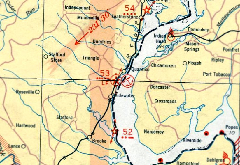
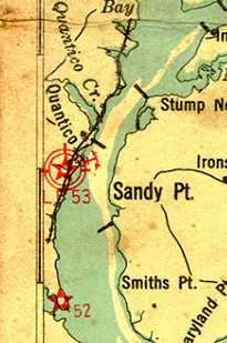
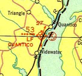
The May 1932 Washington Sectional Chart depicted the Quantico airfield as Intermediate Field Site 53.
A 1930s USMC view of Brown Field #2 in the foreground, Brown Field #1 across the railroad tracks,
and Turner Field (the present-day Quantico airfield) under construction in the background.
A 1930s USMC view of Brown Field #2.
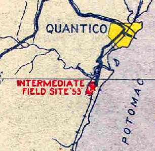
Quantico "Intermediate Field Site 53", as depicted on the 1934 U.S. Navy Aviation Chart (courtesy of Chris Kennedy).
Quantico's airfield & seaplane base, as depicted on the 1935 Washington Sectional Chart.
A circa 1935-40 USMC photo by Buford Stover of a Great Lakes BG-1 dive-bomber biplane landing on Brown Field.
A circa 1935-41 USMC photo by Buford Stover of buildings & hangars at Brown Field.
The hangars at Brown Field #1 were dismantled & moved across the railroad tracks to Brown Field #2,
and Turner Field was dedicated in 1936.
Brown Field #2 was apparently also used as one of the Department of Commerce's network of Intermediate Fields,
established across the country in the 1930s to provide emergency landing sites
for commercial airliners operating along routes between major cities.
The 1/1/1936 Department of Commerce Airway Bulletin
described Quantico as the Department of Commerce's Site 53 along the Atlanta-NY Airway.
The field was said to consist of an irregularly-shaped sod field,
measuring 2,450' north/south.
Hangars were said to be marked with “U.S. Marines”.
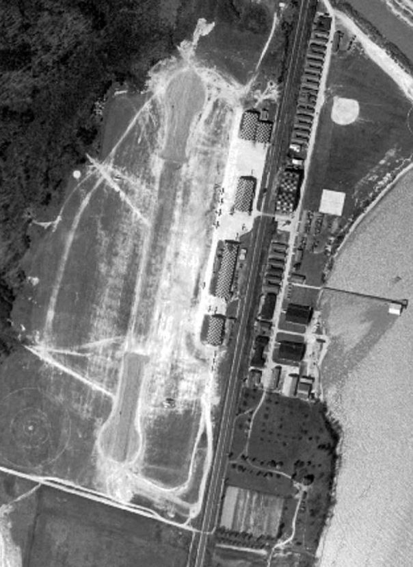
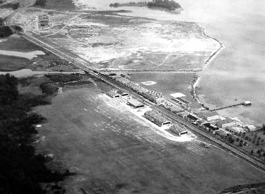
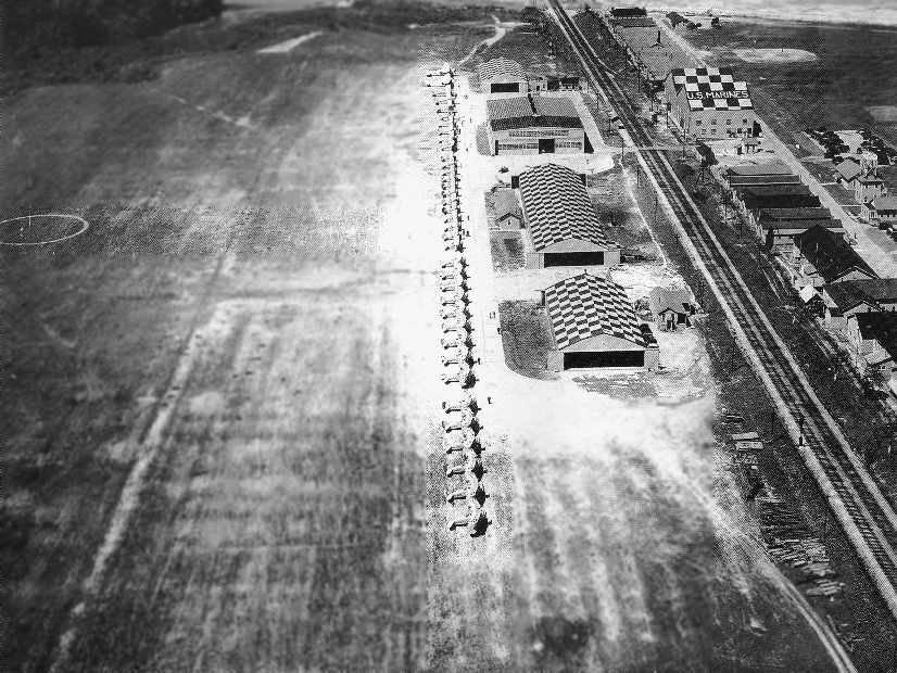
A 1937 aerial view (courtesy of David Cuff) depicted Brown Field as having a north/south runway, with 5 checkerboard-roofed hangars & at least 6 aircraft.
The Airport Directory Company's 1937 Airports Directory (courtesy of Bob Rambo)
described the airfield along the west side of the railroad tracks at Quantico
as the Department of Commerce Intermediate Field "Site 53", along the Atlanta-NY airway.
It was described as having a 2,400' sod north/south runway,
and the hangars were said to have "Marine Corps Quantico, VA" painted on the roof.
"Brown" Field was depicted on the September 1940 Washington Sectional Chart.
By the time of the November 1941 Washington Sectional Chart,
Brown Field was no longer depicted, having been replaced by the nearby Turner Field.
A 1943 aerial view of Brown Field #2 (National Archives photo).
During WW2, the Assembly & Repair Department overhauled a large number of aircraft & engines
in a large building on the northern portion of the former Brown Field #1.
That building eventually became Quantico's present-day Larson Gym.
Brown Field #2 was closed for aircraft operations during the war,
but its runway was used for parking aircraft going through the Assembly & Repair Department.
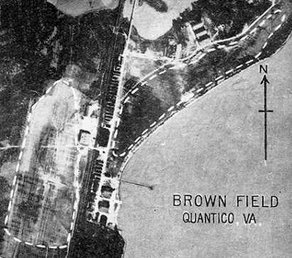
A 9/24/43 aerial view looking north at Quantico depicted Brown Field #2 at the bottom-left, Brown Field #1 at the bottom-right,
and the replacement Turner Field at the top-right.
After WW2, the airfield area at Brown Field #2 was once again used,
to develop the Marine Corps' new tactics in helicopter assault.
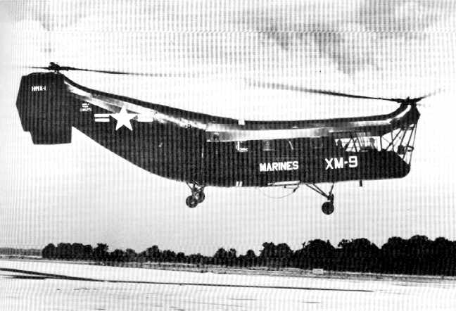
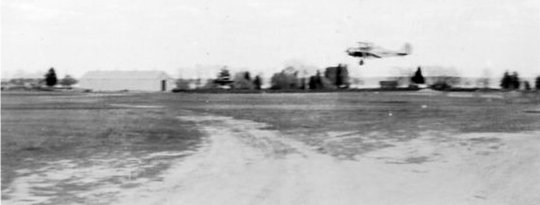
A circa 1947-50s photo of HRP-1 "Flying Banana" landing at Brown Field.
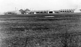
A 1954 aerial view (from the Prince William County Mapper) showed buildings had been built over some portions of Brown Field,
but the row of hangars remained along the east side.
A 1971 aerial photo showed the airfield site & hangars remained largely unchanged.
In the 1980s the remaining 1920s vintage hangars were reused as the location of the Marine Corps Air-Ground Museum,
which held a collection of USMC aircraft.
Paul Freeman visited the museum in the 1980s.
A 1981 aerial photo showed at least 5 aircraft of the Marine Corps Air-Ground Museum on display in between the Brown Field hangars.
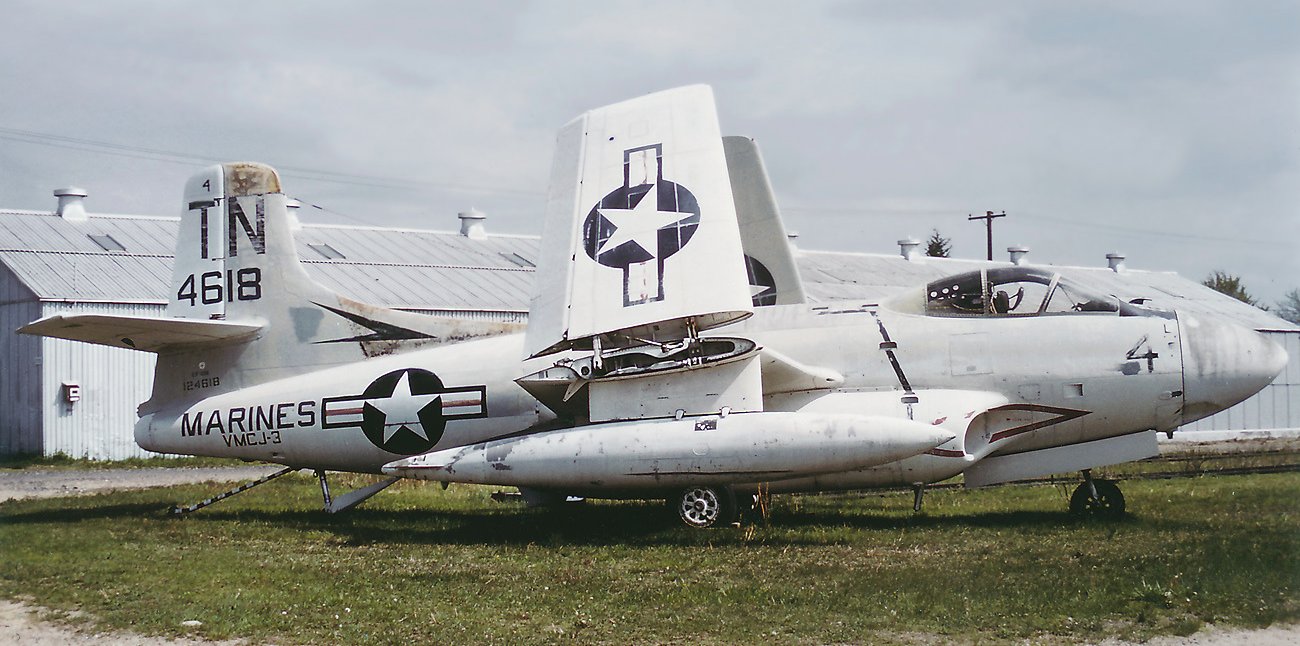
An October 1983 photo of a USMC Douglas EF-10B Skynight, 124618, C/n 7488, part of the Marine Corps Air-Ground Museum collection, in front of a Brown Field hangar.

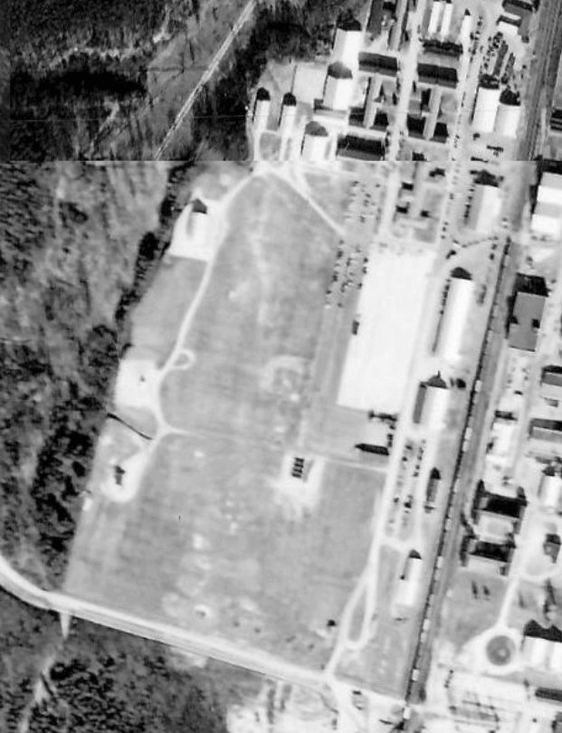
A 1994 USGS aerial photo of the site of Brown Field #2 (west of railroad tracks) & Brown Field #1 (east of railroad tracks).
The end of Runway 2 of the present-day MCAS Quantico Turner Field is at the northeast corner.
Several buildings housing the Marine Corps' Officer Candidate School
have been built along the former airfield area of Brown Field #2.
However, the 1920s era hangars still exist along the west side of the railroad tracks,
and the former Assembly & Repair Department building on the east side still exists as well.
As of 2003, the Marine Corps Air-Ground Museum was closed,
awaiting a move from the Brown Field #2 site to a new location along the east side of Interstate 95.
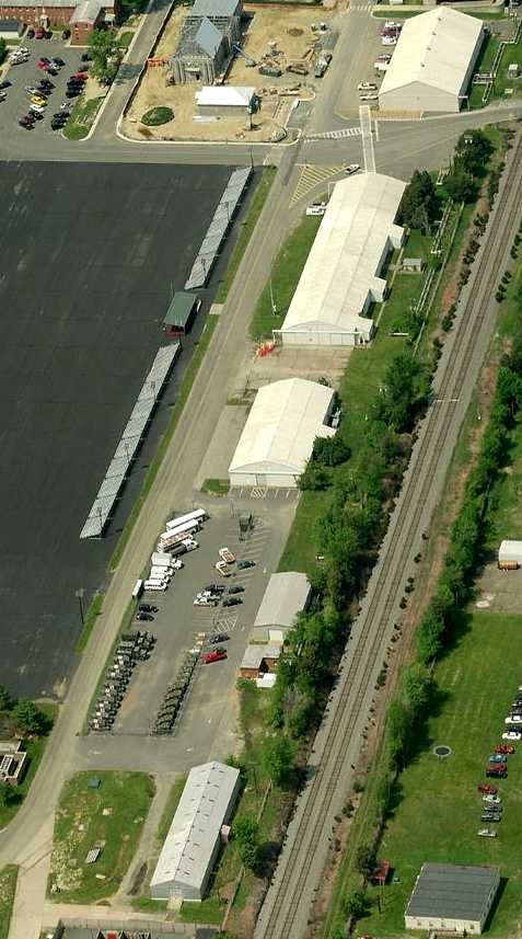
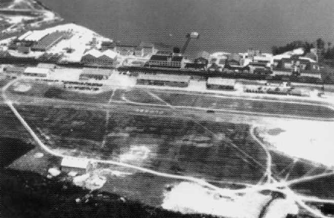
A circa 2010 aerial view looking north at the row of 1920s-era hangars which remain standing along the east side of the site of Brown Field.
Thanks to John Voss for pointing out Brown Field.
____________________________________________________
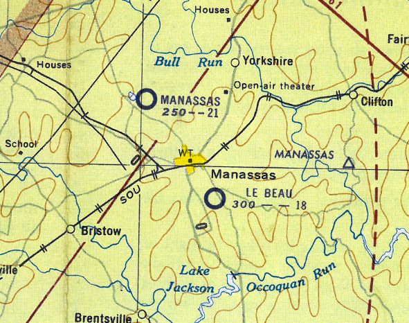
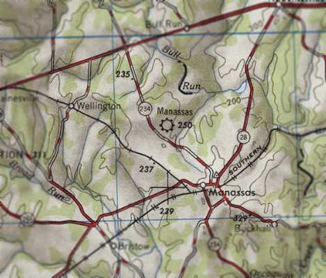
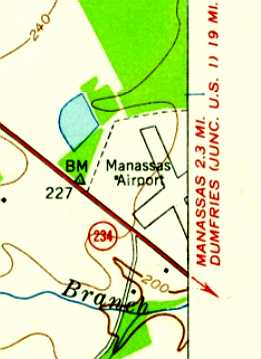
Original Manassas Municipal Airport, Manassas, VA
38.775, -77.5 (Southwest of Washington, DC)
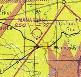
The original Manassas Airport, as depicted on the October 1933 Washington Sectional Chart.
As described on the City of Manassas' web site,
the Manassas Town Council proposed in 1930 that a landing strip be constructed along Route 234 near Manassas.
A group of investors purchased almost 95 acres of land along the northeast side of Route 234
and leased it to the Town in 1931.
Over the next few years an additional 12.6 acres were purchased & several improvements were made at the airport.
Manassass Airport was not yet depicted on the May 1932 Washington Sectional Chart.
The earliest depiction which has been located of Manassas Airport was on the October 1933 Washington Sectional Chart.
It depicted Manassass Airport as an auxiliary airfield located northwest of the town.
The 1934 Department of Commerce Airfield Directory (according to Chris Kennedy)
described Manassas Airport as having 2 sod runways,
with the longest being a 2,100' northeast/southwest strip.
The 1/1/36 Department of Commerce Airway Bulletin
described Manassass Airport as an auxiliary airfield, consisting of a rectangular sod field.
It was said to have 2 runways: 2,100' northeast/southwest & 2,050' northwest/southeast.
The field was said to offer no servicing.
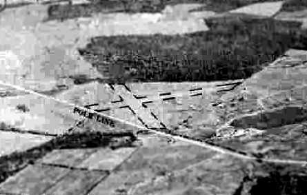
A 1936 aerial view looking southeast at the original Manassass Municipal Airport.
According to the book "Virginia Airports" by Vera Rollo & Norman Crabill (published by the VAHS),
"Fancis 'Hobs' Compton began giving passenger rides in August of 1936."
The Airport Directory Company's 1937 Airports Directory (courtesy of Bob Rambo)
described Manassas Municipal Airport as having two 1,800' runways & a small hangar.
A 4/30/37 aerial view (courtesy of David Cuff) depicted Manassas Municipal Airport as having 2 grass runways, with an airport circle marking at the intersection.
According to the book "Virginia Airports",
"Just before WW2 Bob Ashburn leased space for the Ashburn Flying Service for $35 a month & offered FBO services.
The war temporarily suspended flying & when flying was resumed, there were more restrictions on pilots & on flying."
Manassas Airport was described in the 1944 US Army/Navy Directory of Airfields (courtesy of Ken Mercer)
as having a 2,200' runway.
In 1945 the airport was purchased by the Town of Manassas.
A circa 1942-45 aerial view looking east at Manassas Municipal Airport
from the 1945 AAF Airfield Directory (courtesy of Scott Murdock) depicted the field as having 2 grass runways.
The 1945 AAF Airfield Directory (courtesy of Scott Murdock) described Manassas Municipal Airport
as a 94 acre irregularly-shaped property within which were two 2,100' sod runways, oriented northeast/southwest & NNW/SSE.
The field was said to not have 2 wooden hangars (measuring 50' square & 40' x 27'),
and to be privately owned & operated.
The original Manassas Airport, as depicted on the 1946 USGS topo map.
The 1947 Washington Sectional Chart depicted the original Manassas Airport as having a 2,200' unpaved runway.
According to the book "Virginia Airports", "After the war the 'GI Bill' increased flying at the airport
and a second operator took over, the Manassas Flying Service.
In October 1949 Dudley Watts became airport manager."
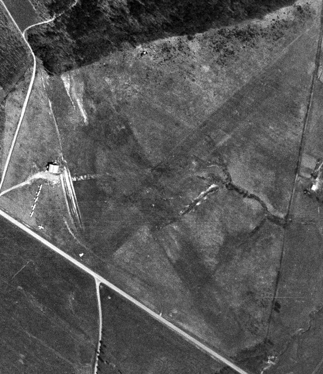
A 4/10/49 USGS aerial view depicted the original Manassas Airport
as having 2 unpaved runways, with a hangar & 6 light aircraft on the west side of the field.
On the 1951 Washington Sectional Chart (courtesy of Mike Keefe),
Manassas Airport was described as having 2 runways, with the longest being a 2,160' unpaved strip.
The 1953 USGS topo map depicted the original Manassas Airport as having 2 runways.
According to the book "Virginia Airports",
"In March of 1955, Charles Kulp became the airport manager
and taught many to fly in subsequent years.
He liked to fly a ski-equipped Piper Cub.
It was here, too, that he perfected his Piper Cub Flying Farmer act & helped put on air shows."
[Charlie Kulp was still performing the 'Flying Farmer' comedy act as of 2003, at the Warrenton Flying Circus.]
The 1956 Washington Local Aeronautical Chart (courtesy of Tim Zukas)
depicted the original Manassas Airport as having a 2,100' unpaved runway.
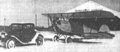
While managing the Manassas Airport, Charlie Kulp purchased & restored a 1929 Fairchild KR-34,
which as of 2006 belongs to the Smithsonian Air & Space Museum
(according to an article by Linda Burdette in the 1/06 issue of the VAHS Virginia Eagles newsletter).
Merton Meade recalled, “The old Manassas Airport was fun, especially when Charlie Kulp ran it.
After we moved to Hyde Field from Beacon Field,
we'd take a couple of Champs to Manassas every weekend to give instruction.
At the time Frank Marshall & Dudley Watts were running the place.
Bob Ashburn also operated out of old Manassas, but that was well before my time.”
On the 1958 Washington Sectional Chart, Manassas Municipal was described as having a 2,200' unpaved runway.
Bill Marshall recalled, “My parents [Frank & Evelyn Marshall] ran the old Manassas Airport from the late 1950s until it moved to the 'new' Manassas Airport.”
"In early 1960 ten new T-hangars were built" (according to the book "Virginia Airports").
According to Paul Bombardier, “The 10 unit T-hangar was built by Paul Bryce of Basye, VA.”
The February 1961 Washington Local Aeronautical Chart (courtesy of Scott Kimball)
depicted Manassass as having a 2,200' unpaved runway.
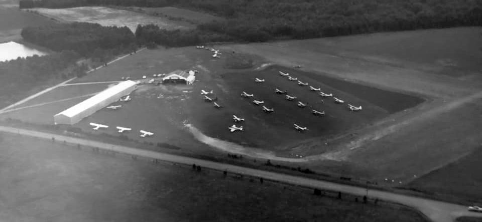
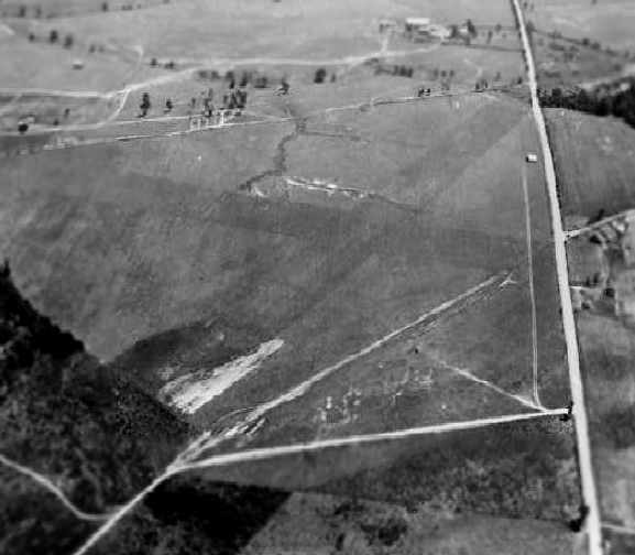
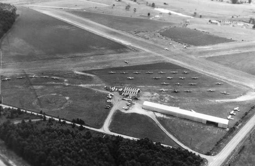
A 1961 aerial view looking north (from the collection of Bill Marshall) depicted the original Manassas Airport
as having 2 unpaved runways, with 2 hangars & 33 aircraft on the west side of the field.
A 1962 aerial view depicted the original Manassas Airport
as having 2 unpaved runways, with 2 hangars & 22 aircraft on the west side of the field.
An undated (circa 1960s?) aerial view by Paul Bombardier looking east at the original Manassas Airport.
Paul recalled, “I worked part time at this airport from 1960-64 as an Airframe & Powerplant mechanic.
At this time, Frank & Evelyn Marshall (Airport Management Inc.) were the operators & managers.
Previously, the operators were Dudley Watts & Charlie Kulp.”
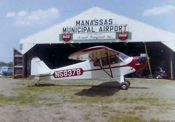
A 1962 photo by Paul Bombardier of a 1946 Piper J-3 Cub in front of the hangar at the original Manassas Airport.
Paul recalled, “The Piper Cub N58378 was owned by Dudley Watts & Charlie Kulp.
I & two friends purchased this aircraft from them in 1961
and rebuilt it from scratch, and then learned to fly in it.”
Due to increased activity at the airport & encroaching housing development,
the Town saw the necessity of moving the airport to a new location.
Property was purchased for a replacement airport in 1963, four miles to the south.
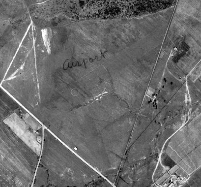
The original Manassas Airport, as depicted on the 1963 USGS topo map.
The original Manassas Airport was described on the 1964 Washington Local Aeronautical Chart (courtesy of Mike Keefe)
as having 2 runways, with the longest being a 2,260' turf strip.
A 1964 aerial view showed a total of 10 light aircraft parked outside at the original Manassass Airport.
The property of the original Manassas Airport was sold to shopping center developers Lindsey & Waldron on 4/17/64.
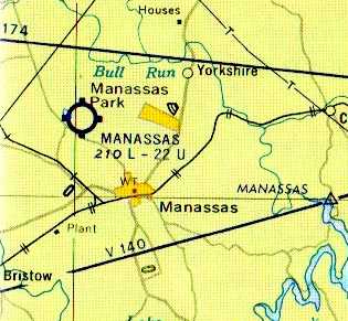
The new Manassas Regional Airport (3 miles to the southwest) was dedicated on 9/20/64,
at which point the old airport presumably was closed.
The 10 newly-built T-hangars at the original Manassas Airport were relocated in 1964 by Paul Bayse to the Winchester Airport,
which was also operated by Frank Marshall's Airport Management.
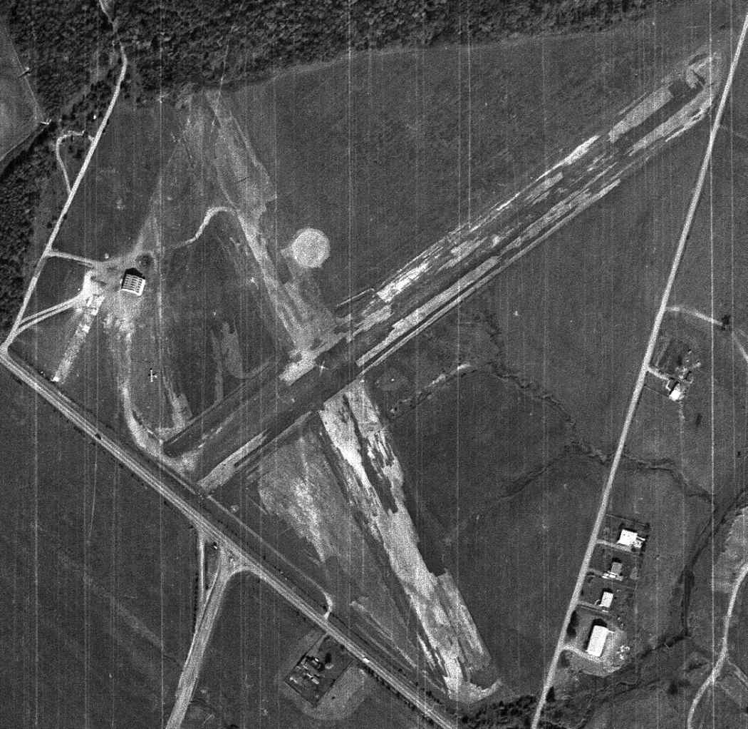
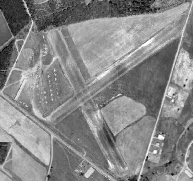
A 10/26/64 USGS aerial view depicted the original Manassas Airport shortly after its closure,
with the row of T-hangars having just been removed, but the main hangar still remained, as well as the runways.
By the time of the April 1965 Washington Sectional Chart,
only the new Manassas Airport (southwest of the town) was depicted - the original Manassas Airport was no longer depicted.
A 1979 aerial view showed that a shopping center had covered the property,
with not a trace still visible of the original Manassass Airport.
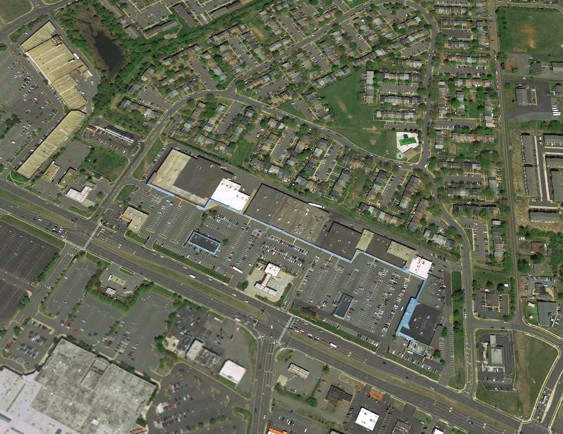
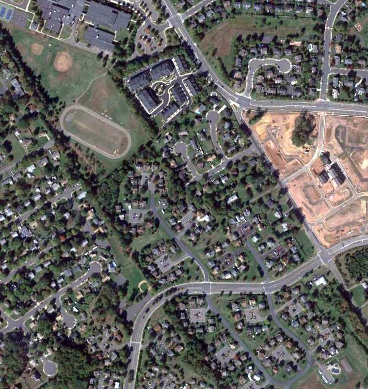
A 2018 aerial view looking northeast at the site of the former Manassas Airport, now occupied by the Manaport Shopping Center & houses.
Not a trace remains of the former airport.
According to Paul Bombardier, “The runway intersection stood right in the center of the townhouses,
and the L-shaped shopping center at the left is where the hangar stood.”
The site of the original Manassas Airport is located on the northeast side of Route 234, directly across from the Manassas Mall.
____________________________________________________
Since this site was first put on the web in 1999, its popularity has grown tremendously.
If the total quantity of material on this site is to continue to grow,
it will require ever-increasing funding to pay its expenses.
Therefore, I request financial contributions from site visitors,
to help defray the increasing costs of the site
and ensure that it continues to be available & to grow.
What would you pay for a good aviation magazine, or a good aviation book?
Please consider a donation of an equivalent amount, at the least.
This site is not supported by commercial advertising –
it is purely supported by donations.
If you enjoy the site, and would like to make a financial contribution,
you
may use a credit card via
![]() :
:
Please consider checking the box to make a monthly donatation.
For a mailing address to send a check, please contact me at: paulandterryfreeman@gmail.com
If you enjoy this web site, please support it with a financial contribution.
please contact me at: paulandterryfreeman@gmail.com
If you enjoy this web site, please support it with a financial contribution.
____________________________________________________
This site covers airfields in all 50 states.