Abandoned & Little-Known Airfields:
Virginia: Loudoun County
© 2002, © 2022 by Paul Freeman. Revised 8/7/22.
This site covers airfields in all 50 states: Click here for the site's main menu.
____________________________________________________
Please consider a financial contribution to support the continued growth & operation of this site.
Birch Hollow Airfield (revised 4/11/15) - Blue Ridge Airport (revised 2/13/22) - Glascock Airport / Glascock Field (revised 3/25/22)
Coonskin Farm Airfield / Goose Hunt Farm Airfield (added 9/27/14) - June Field (revised 8/7/23)
Lipscomb Airfield (revised 5/5/18) - Richardson Field (revised 4/24/22) - Smith Airport (revised 4/11/15)
Strobel Airfield (revised 4/11/15) - Wallace George Field / Godfrey Field / (Original) Leesburg Municipal Airport (revised 2/9/20)
____________________________________________________
Wallace George Field / Godfrey Field / (Original) Leesburg Municipal Airport,
Leesburg, VA
39.113, -77.546 (Northwest of Washington, DC)
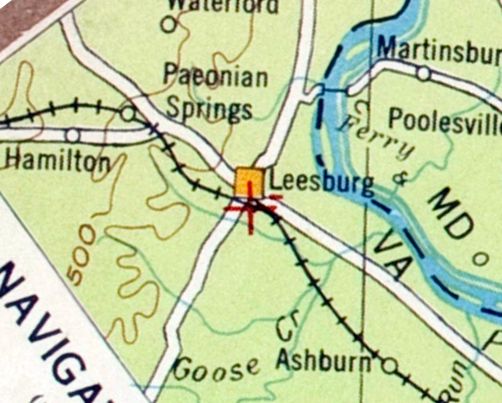
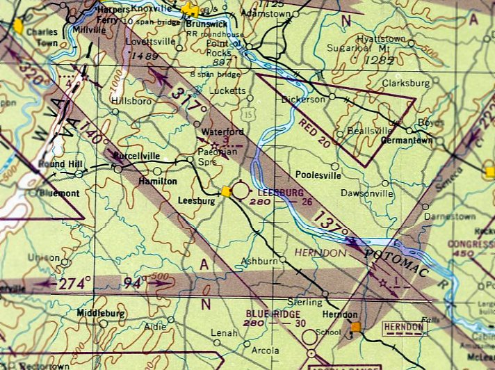
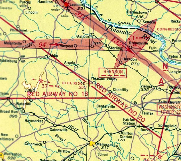
Leesburg Airport, as depicted on the 1929 Air Navigation Map #3.
Leesburg's original airport was originally a cow pasture, located on the south side of Edward's Ferry Road, west of Route 15.
The first plane landed on the field in 1918, when the property was known as the George Farm, owned by Wallace George.
George's stone house was located on the south side of 229 Edward's Ferry Road.
According to the book "Loudoun Discovered", many barnstormers performed on what was known at the time as the "Cow Pasture Airport",
and were most likely the first aircraft to operate in Loudoun County.
As recounted in the book "Within the Iron Gates", rides were sold for an average of $5,
and the highlight of the show would be a parachute jump.
The facilities at the George Farm didn't quite amount to an airstrip,
but was rather a bumpy mowed path through the center of the George property.
According to FAA Historian Theresa Kraus's report “From Cow Pasture to Executive Airport” (courtesy of Dennis Boykin),
“In an airport listing in December 1929, the Aeronautics Branch identified Leesburg as having an auxiliary field.”
The earliest depiction which has been located of the Leesburg Airport was on the 1929 Air Navigation Map #3.
It depicted an auxiliary airfield south of the center of the town,
different from the location of the George Farm Airfield,
but this may have been due to the lack of precision of early aeronautical charts.
The Leesburg / George Farm airfield was not yet depicted on the May 1932 Washington Sectional Chart
nor listed in the 1934 Department of Commerce Airfield Directory (according to Chris Kennedy).
The earliest dated photo which has been located of the Wallace George Farm was a 1937 USDA aerial view.
It did not yet show any recognizable sign of an airfield.
According to FAA Historian Theresa Kraus's report “From Cow Pasture to Executive Airport” (courtesy of Dennis Boykin),
“In the mid-1930s, the Works Progress Administration began providing funds to states to help identify airports for pilots aloft.
The National Airmarking Program in Virginia painted 'Leesburg' on the barn at the George Farm, and his landing strip became known for a while as the Leesburg airfield.
Wallace George died in 1938.”
During WW2, the federal government leased the property, with the intent of developing a more substantial airfield.
A 1942 article in the Loudoun Times Mirror gave details:
"Location at Leesburg of one of numerous airfields being constructed at strategic points throughout the nation
appeared a certainty with the disclosure of an agreement between A.T. Elgin & J.L. Whitted,
representative of the federal government,
for the lease of 15 acres of land on the west side leading from Route 7 to Dry Mill Road.
This could be one of a chain of emergency fields that are being constructed by the Army & Navy along the Atlantic Seaboard."
According to FAA Historian Theresa Kraus's report “From Cow Pasture to Executive Airport” (courtesy of Dennis Boykin),
“Despite the paper’s speculation, the government did not make any improvements to the field.
In 1944, a group of investors bought the George farm hoping to turn the field into a bona-fide airport.”
The News (of Frederick MD) reported that “an airport & hangar will be constructed on a 40-acre plot on the estate of the late Wallace George.
All types of flight training will be offered,” by the Washington Flying Service, which planned to have 22 aircraft at the airport.
James Jones, John Talbot, and G. E. Carlson were listed as sponsors of the project.
Construction work on the airport began in early July 1944.
The Washington Flying Service also managed Washington-Hoover Airport.
A single hangar was built on the George Farm Airstrip during WW2.
There still was no airfield depicted at Leesburg on the 1944 USGS topo map.
According to FAA Historian Theresa Kraus's report “From Cow Pasture to Executive Airport” (courtesy of Dennis Boykin),
“In September 1944, the Washington Flying Service petitioned the State of VA Corporation Commission
for permission to establish a permanent airport at the Leesburg site.
The company had already established a flying school at the field on a temporary basis.
During 2 days of testimony, John Talbot, president of the Flying Service said the airport would be an attractive airpark
with such adornments as a swimming pool & landscaping.
Opponents of the flying school testifying before the commission included Judge J. Alexander,
who argued that the noise caused by low-flying airplanes would be a nuisance & that the airport would create hazards that would lower property values.
Other property owners near the airport contended that the airport constituted a hazard to livestock.
Apparently, the commission voted in favor of the residents & the Leesburg airpark remained undeveloped.”
There still was no airfield depicted at Leesburg on the June 1945 Washington Sectional Chart.
The December 1945 Washington Sectional Chart depicted Leesburg as a commercial/municipal airport on the east side of the town.
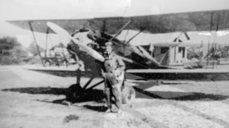
An undated photo of an unidentified pilot in front of a biplane at the original Leesburg Airport.
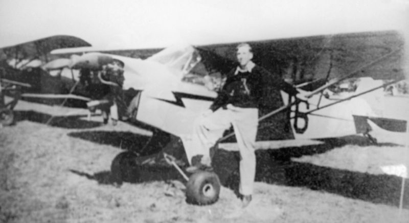
An undated photo of an unidentified pilot in front of a Piper J-3 Cub at the original Leesburg Airport.

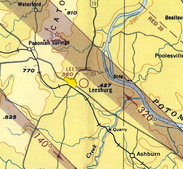
The “Leesburg Airpark”, as depicted on the 1946 USGS topo map.
According to FAA Historian Theresa Kraus's report “From Cow Pasture to Executive Airport” (courtesy of Dennis Boykin),
“The Washington Flying Service’s hopes of creating a thriving airpark never materialized
and, in 1946, the group sold the airfield to Arthur Hyde.
Hyde owned & operated Congressional Airport in Rockville MD & Hyde Field Airport in Clinton MD.
Hyde made no improvements to the field.
However, the Leesburg Airpark appeared on the 1946 Washington Sectional Aeronautical Chart.”
The April 1947 Washington Sectional Chart described Leesburg Airport as having a 2,600' unpaved runway.
Buddy DiZerega, Ross Lipscomb, and Tex Gray held airshows at the George Farm Airstrip in 1947-48.
The move of radio celebrity & pilot Arthur Godfrey to Leesburg brought the town much notoriety,
and he began landing his plane at the George Farm Airfield.
Godfrey began referring to the field as the "International Cow Pasture".
According to FAA Historian Theresa Kraus's report “From Cow Pasture to Executive Airport” (courtesy of Dennis Boykin),
“In June 1950, Godfrey purchased the airport from Hyde.”
A local paper reported that “it was understood that Godfrey plans extensive improvements to the field, used by him in flying to & from his home near Paeonian Springs.”
The airfield became known as Godfrey Field.
Shortly after acquiring the land, Godfrey offered to donate 58 of the 100 acres to the town of Leesburg, including the airport.
The town tentatively accepted the donation contingent on the approval of the town attorney.”
The land, according the transfer, “is to be used as a public airport for 20 years.
Otherwise, the title will revert to Mr. Godfrey. At the end of 20 years, Leesburg would obtain title without restrictions.”
According to FAA Historian Theresa Kraus's report “From Cow Pasture to Executive Airport” (courtesy of Dennis Boykin),
“By this point, the airfield consisted of a single grass strip, which was level for about a thousand feet,
then had a gully followed by a hill & then downtown Leesburg.
There was a single wooden hangar with attached office, concrete apron & gas pumps.
The town formally accepted the donated land & airfield in February 1951.
With town ownership, came opportunity to seek Civil Aviation Administration (CAA) grant money for airport improvements, money not available to a private owner.
The town apparently wanted to seek CAA funding to construct a 3,000' runway. Funding never came through.”
Leesburg Airport was depicted on the January 1951 Washington Local Aeronautical Chart (courtesy of Tim Zukas)
as having a 2,000' unpaved runway.
Leesburg Airport was described on the 1951 Washington Sectional Chart (courtesy of Mike Keefe)
as having 2 runways, with the longest being a 2,000' unpaved strip. The remarks said, "Inactive, usable."
According to FAA Historian Theresa Kraus's report “From Cow Pasture to Executive Airport” (courtesy of Dennis Boykin),
“The field, however, was not inactive, but used primarily by Godfrey.
Godfrey’s fleet included a number of aircraft, including a helicopter & a DC-3.
Soon, the town council found itself dealing with a number of complaints about noise & the rattling of windows as Godfrey took off & landed.”
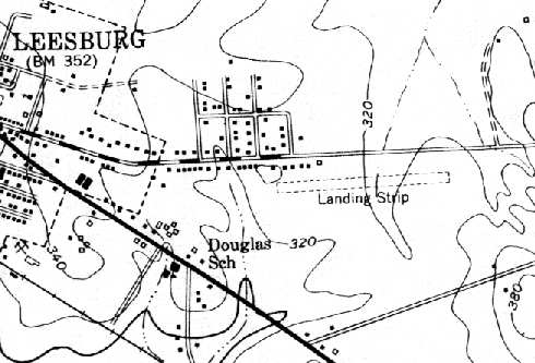
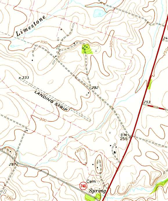
Godfrey Field, labeled "Landing Strip", as depicted on the 1952 USGS topo map.
According to David Pearce, the field had "Not much else except for a lazy ole stupid cat family
who used to steal your food right out of your mouth if you didn't watch them."
He flew into the old field many times during his flight training in 1955-56.
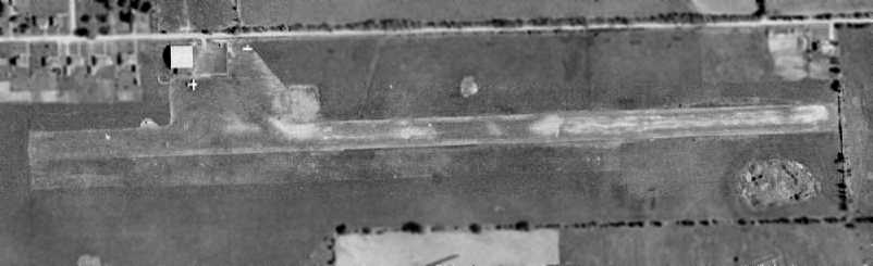
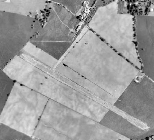
The earliest photo which has been located of the original Leesburg Airport was a 1957 USDA aerial view (courtesy of Dallam Oliver-Lee).
It depicted the field as having a single east/west grass runway,
with the original runway parallel on the south side.
A single hangar was visible on the northwest side, along with 2 light aircraft.
The 1957 Washington Sectional Chart (courtesy of Mike Keefe)
described Leesburg Municipal Airport as having 3 runways, with the longest being a 3,500' turf strip.
A 1958 aerial view depicted Leesburg as having a single east/west grass runway,
with the original runway parallel on the south side.
A single hangar was visible on the northwest side, along with 2 light aircraft.
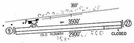
The 1960 Jeppesen Airway Manual (courtesy of Chris Kennedy)
depicted the Leesburg Airport as having a 3,500' Runway 9/27,
with a 2,900' "Old Runway" running parallel on the south side.
A curious note said, "Small aircraft use old runway."
The David Pearce flying school started at Leesburg in 1960,
with "a fleet of one Piper PA-11 Cub, and a Sanderson ground school course."
The February 1961 Washington Local Aeronautical Chart (courtesy of Scott Kimball)
described the original Leesburg Municipal Airport as having a 3,500' unpaved runway.
With the continuing growth of the town of Leesburg,
the airfield which was previously located outside of the town was soon surrounded by it instead.
In 1962 the town council contracted with an engineering firm
to examine alternative sites further out of town for a replacement airport.
A site 2 miles to southeast was eventually chosen for the replacement Leesburg Municipal Airport.
According to FAA Historian Theresa Kraus's report “From Cow Pasture to Executive Airport” (courtesy of Dennis Boykin),
“The town received permission from Arthur Godfrey to sell the 58 acre site with the airfield that he donated to the town, if the town used the proceeds to build a bigger airport.
Tri-State Properties, Inc. & affiliate of Investor Service, Inc., purchased the 58 acre old airport site in October 1962.”
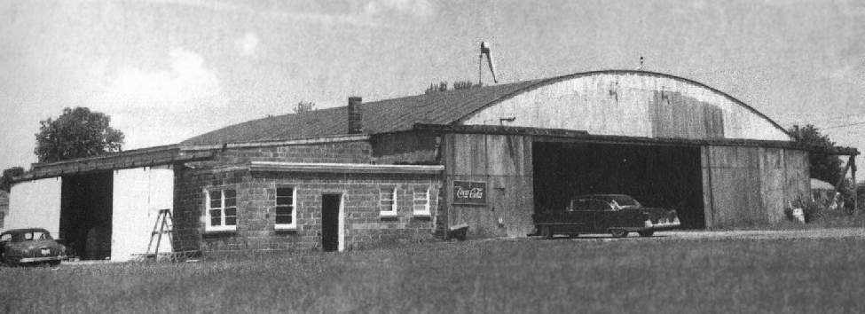
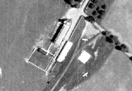
Undated photo of a hangar at Leesburg's original airport.
An undated aerial view looking west at Godfrey Field.
The photo is from the brochure commemorating the inauguration of the new Leesburg Airport,
and had the caption, "Leesburg's growth-antiquated original airport site."
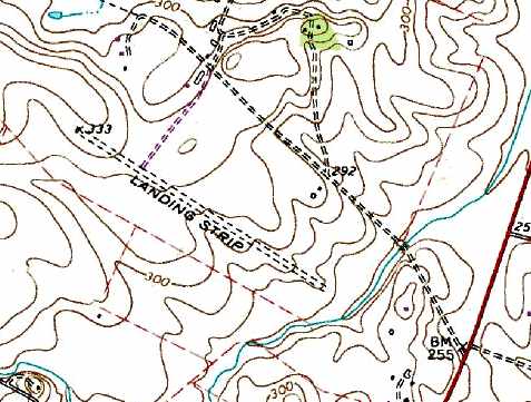
The original Leesburg Airport, as depicted on the 1963 USGS topo map.
Burl Tolley recalled, “The old Leesburg Airfield... My dad learned to fly there in 1963 when I was only 5 years old.
I can remember watching gliders being towed aloft by a Supercub & some parachute jumping that took place there.
What a lot of good memories I'll always cherish from back then.”
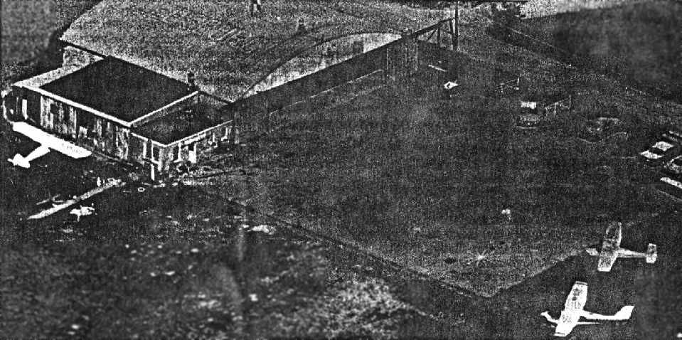
An admittedly poor reproduction of a 1963 aerial view of the hangar & ramp at Godfrey Field, by Sam Legard.
The 1964 Washington Local Aeronautical Chart (courtesy of Mike Keefe)
described the original Leesburg Municipal Airport as having a single 3,100' turf runway.
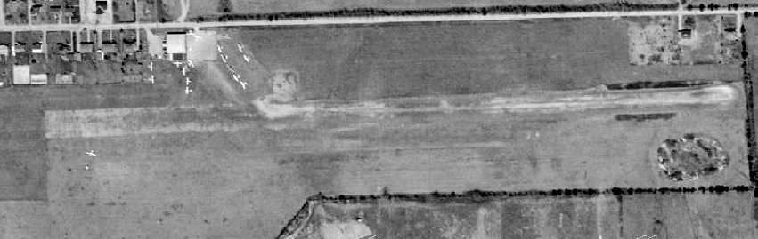
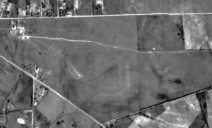
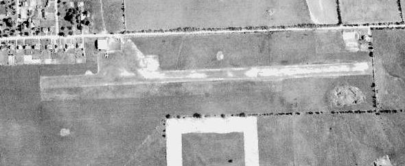
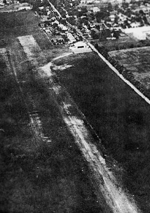
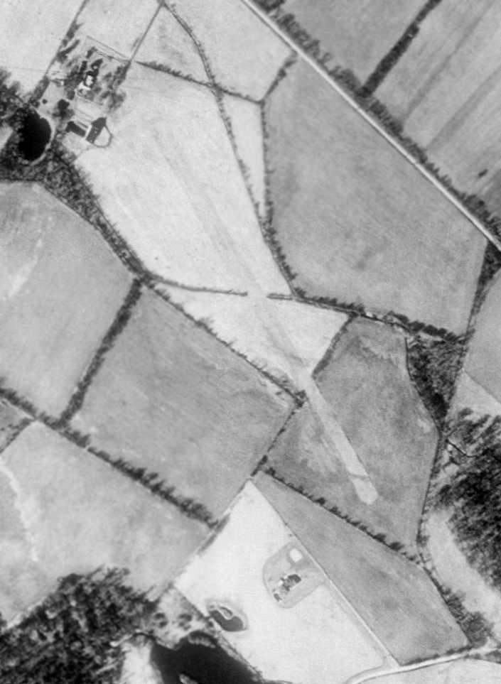
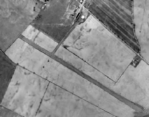
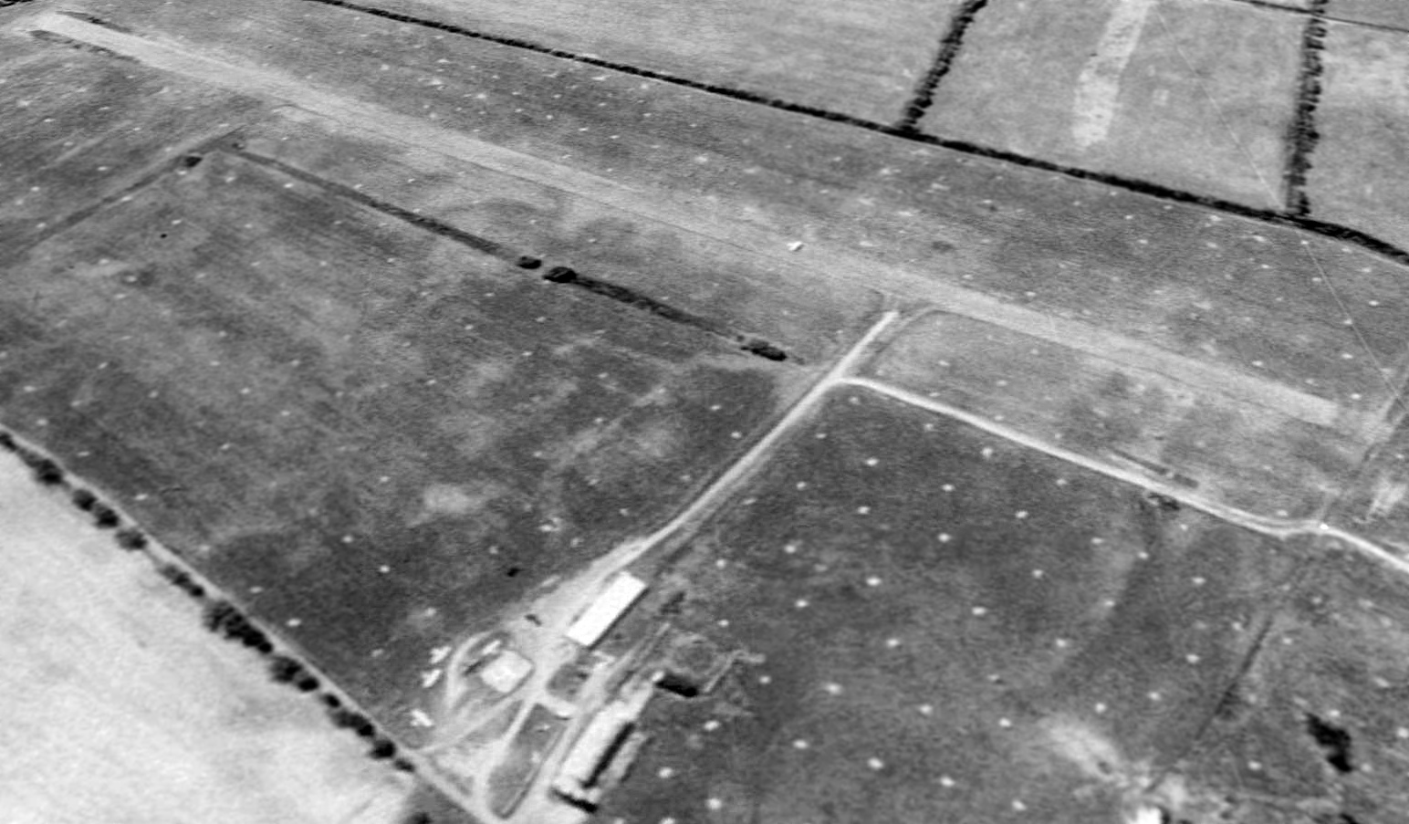
A 1964 aerial view depicted the original Leesburg Airport in its last year of operation.
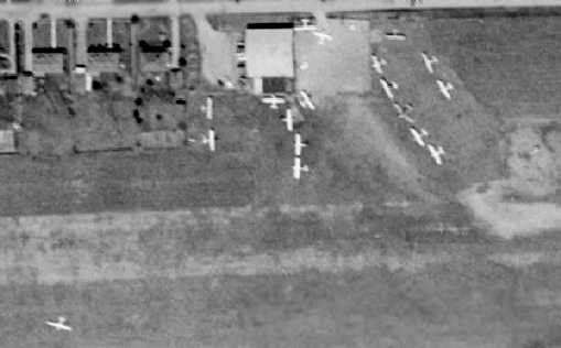
A closeup from the 1964 aerial view of the original Leesburg Airport,
showing a total of 18 light aircraft around the hangar on the northwest side of the field.
The new Leesburg airport was opened in 1964, and the old airport closed in the same week.
The property of the old airfield was sold to a developer, and the proceeds went toward the construction of the new airport.
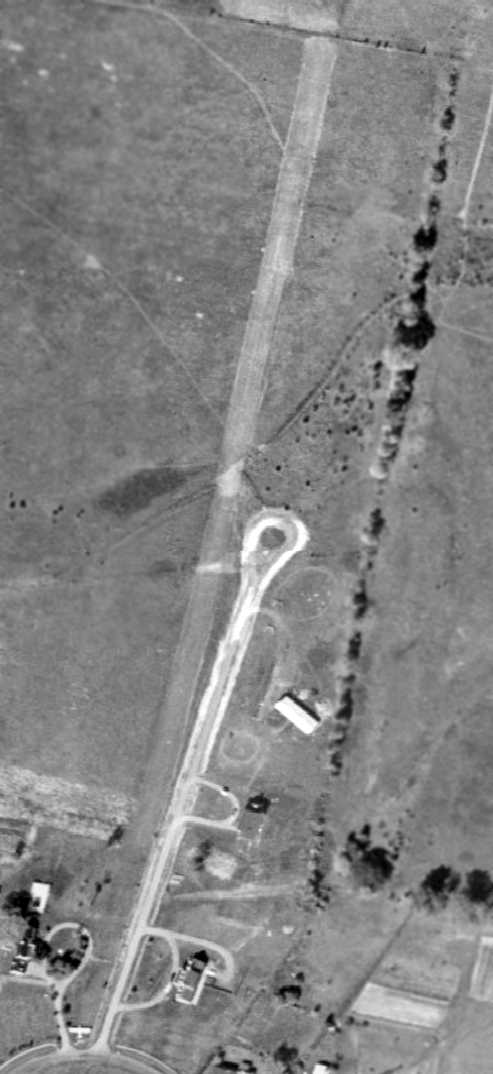
A 4/17/65 USGS aerial view (courtesy of Dallam Oliver-Lee) showed the original Leesburg Airport was still intact, although abandoned.
Only the new Leesburg Airport was depicted on the April 1965 Washington Local Aeronautical Chart (courtesy of John Ferrara)
and the 1968 USGS topo map.
A 4/13/69 USGS aerial view (courtesy of Dallam Oliver-Lee) showed the original Leesburg Airport was still completely intact, although abandoned.
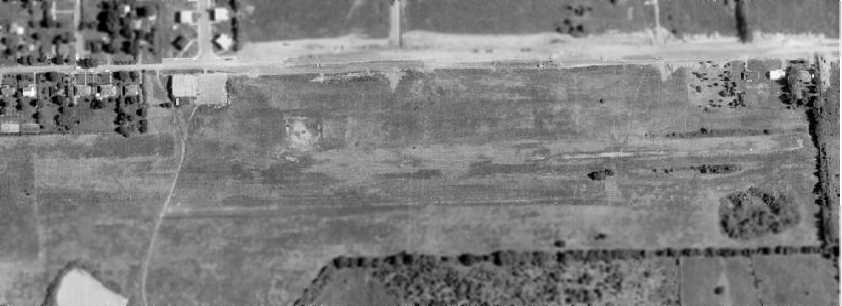
A 1970 aerial view showed the original Leesburg Airport was still completely intact, although abandoned.
A 4/9/72 USGS aerial view (courtesy of Dallam Oliver-Lee) showed that construction had begun of new apartment buildings on the site of the original Leesburg Airport,
although it appears the hangar remained standing.
By the time of a 1974 aerial photo, construction of new apartment buildings had covered the western half of the former runway.
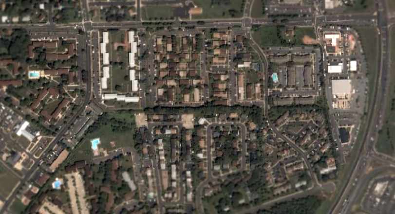
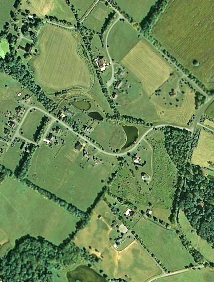
As seen in a 2006 aerial photo, not a trace remains of Old Godfrey Field -
the property along the south side of Edward's Ferry Road
has been heavily developed with apartments & other buildings.
See also: Washington Post, Loudoun News, 11/18/01.
…...................................................................
In 2018, funds were being raised for a memorial to honor the late Stanley Caulkins, a longtime supporter of the Leesburg Airport.
____________________________________________________
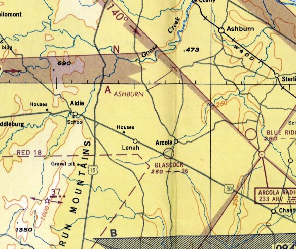
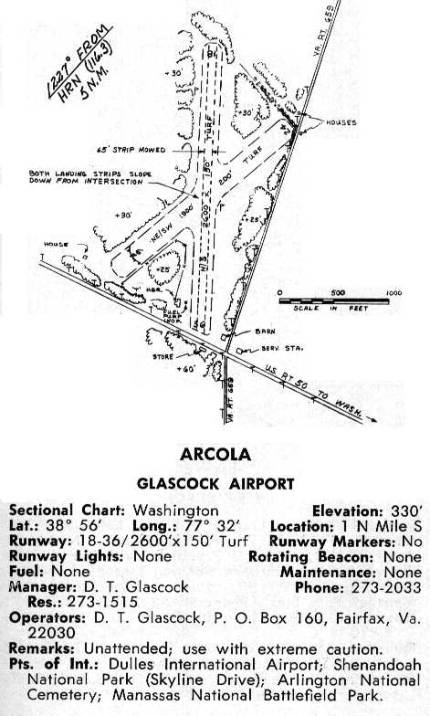
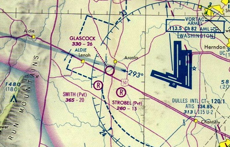
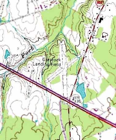
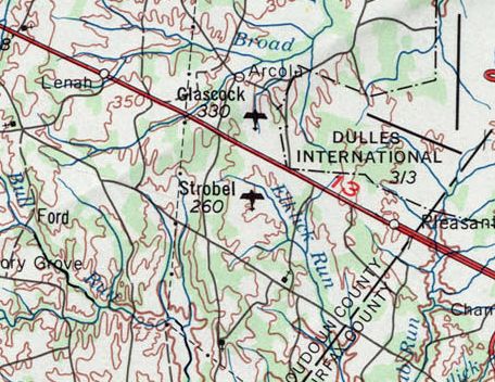
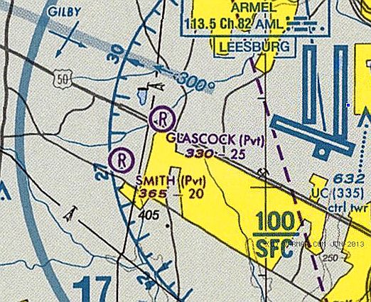
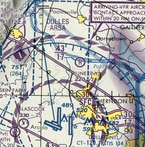
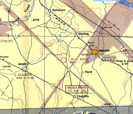
Glascock Airport / Glascock Field (98VA), Arcola, VA
38.942, -77.543 (West of Dulles Airport, VA)
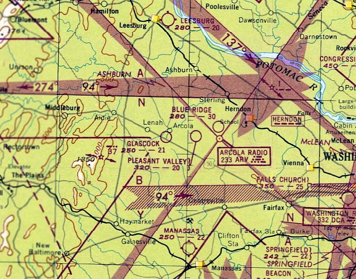
Glascock Airport, as depicted on the April 1948 Washington Sectional Chart.
A 1937 USDA aerial photo (courtesy of Dallam Oliver-Lee) did not yet show any sign of Glascock Airport.
According to the book "Loudoun Discovered" by Eguene Scheel, Glascock Field was laid out by Delmas Glascock in 1941.
Glascock was fascinated by airplanes from an early age, and had always dreamed of owning his own airfield.
He purchased the first 22 acre parcel for his airfield in 1941.
This proved to be unfortunate timing, as the onset of WW2 delayed any further work on the nascent airfield.
Nellie Rutherford, one of Glascock's daughters, recalled, “When [the airfield] was built, I was a little girl.
The family would be out there helping.”
As young man who lived nearby, Forrest “Buddy” Thompson, traded work on the airfield construction project for flying lessons from Glascock.
Thompson worked on the airfield from 1941-42 in exchange for flight lessons from Glascock,
before leaving for military service during WW2.
Glascock purchased his first airplane in the early 1940s - a Piper J-3 Cub.
Glascock Field was not yet depicted at all on the 1943 or 1944 USGS topo maps.
Buddy Thompson went on to earn his wings as a military pilot, and returned to Glascock Airport in 1945.
He gave Glascock Airport's first flying instruction to Delmas Glascock's 13 year old daughter Nellie.
Nellie Rutherford recalled, “I remember flying with my father as a child & then later flying myself as a teenager.”
After the war, Glascock purchased an adjoining parcel of 36 acres in 1946, and graded the north/south runway.
The State of VA issued Glascock Airport an operating license 1946.
However, no airfield at the site was depicted on the 1946 USGS topo map.
According to an article by Lynn Wolstenholme in the 1/2/08 issue of the Loudoun Times-Mirror,
Glascock would fly out of the airport for work.
Johnny Glascock recalled, “I would fly with my dad when he was a bondsman
and he would handcuff [the bail jumper] to me so he wouldn't get away.”
Glascock expanded his stable of aircraft after the war with a Fairchild PT-19 & a Stearman biplane,
and a Stinson 108 Detroiter in 1946.
Thompson took passengers for sightseeing flights in the Stinson, gave flying lessons,
and performed aerobatics in the PT-19 trainer to attract crowds for $5/hour.
The shoulder of Route 50 at the end of Runway 18/36 was the parking lot for the audience.
Glascock Airport was not yet depicted on the October 1947 Washington Sectional Chart.
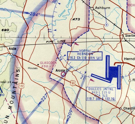
The earliest depiction which has been located of Glascock Airport was on the April 1948 Washington Sectional Chart.
It described Glascock as having 2,100' unpaved runway.
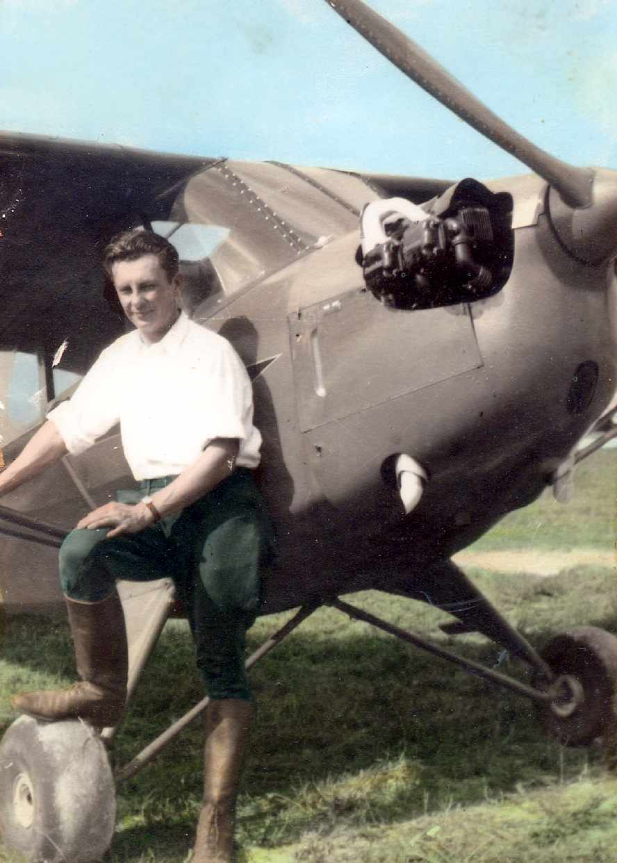
A circa 1940s photo of Delmas “Bill” Glascock in front of one of his first planes (a Piper Cub)
at Glascock Airport (courtesy of Glascock family).
Glascock Airport was described on the 1949 Washington Sectional Chart (courtesy of Mike Keefe) as a 2,100' unpaved runway.
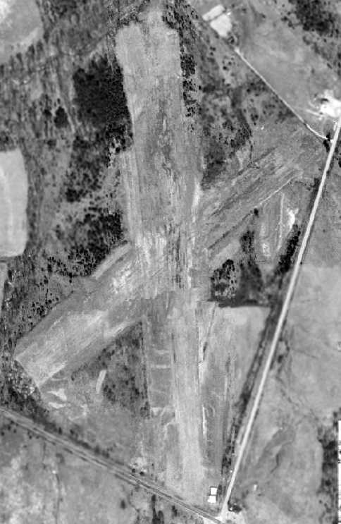
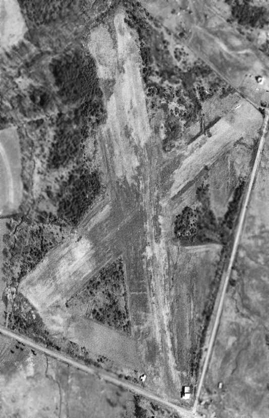
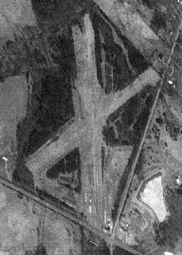
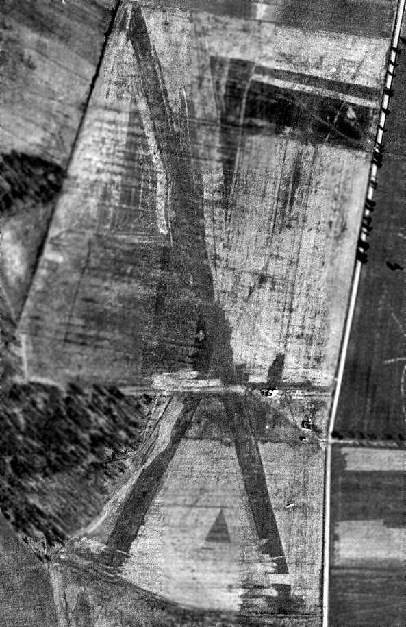
The earliest photo which has been located showing all of Glascock Airport was a 3/21/49 aerial photo.
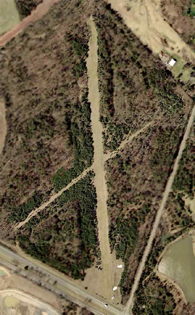
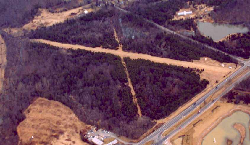
It depicted Glascock as having 2 grass runways.
Note how wide the runways were – they would become noticeably narrower in each subsequent decade.
A broad cleared taxiway also connected the southern end of the 2 runways.
No aircraft were visible on the field, but what appeared to be 2 small hangars were located on the southeast corner.
A 4/10/49 aerial photo showed that a 3rd individual T-hangar had been added on the southwest corner of Runway 36.
A number of local residents learned to fly at Glascock.
The heyday of Glascock Airport was the late 1940s & early 1950s,
when a total of 12-15 aircraft were reportedly based at the tiny field
(but a series of photos from that time period would appear to contradict that assertion).
A 3/30/50 USDA aerial photo (courtesy of Dallam Oliver-Lee) did show any aircraft at Glascock Airport, just the 3 individual hangars.
The January 1951 Washington Local Aeronautical Chart depicted Glascock as having a 2,600' unpaved runway.
Glascock was described on the 1951 Washington Sectional Chart (courtesy of Mike Keefe)
as having 2 runways, with the longest being a 2,600' unpaved strip.
A 3/12/52 aerial photo of Glascock Airport depicted a single-engine aircraft on the northeast end of Runway 24, perhaps preparing to take off.
A 1957 USDA aerial photo (courtesy of Dallam Oliver-Lee) did show any aircraft at Glascock Airport, just the 3 individual hangars.
A 1958 aerial view showed that the 3 small hangars remained on the south end of Runway 36.
Glascock Airport was not depicted on the 1963 USGS topo map.
A 3/19/64 USGS aerial photo (courtesy of Dallam Oliver-Lee) did show any significant differences from the 1958 photo.
The Aerodromes table on the 1964 Washington Sectional Chart (courtesy of John Voss)
described Glascock as having 2 turf runways, with the longest being 2,700'.
A 3/27/65 USGS aerial photo (courtesy of Dallam Oliver-Lee) did show any aircraft at Glascock Airport, just the 3 individual hangars.
The April 1965 Washington Local Aeronautical Chart (courtesy of John Ferrara) depicted Glascock as having a 2,700' unpaved runway.
Note Glascock's proximity to the massive new Dulles International Airport a mere 3 miles to the east.
The largest aircraft to have used Glascock Field was a DeHavilland Twin Otter flown by USAF Col. George Lutz.
It was also visited by Army CH-47 Chinook helicopters.
The 1968 VA Airport Directory (courtesy of Don Thomson) depicted Glascock Field as having 2 grass runways,
and listed the operator as D.T. Glascock.
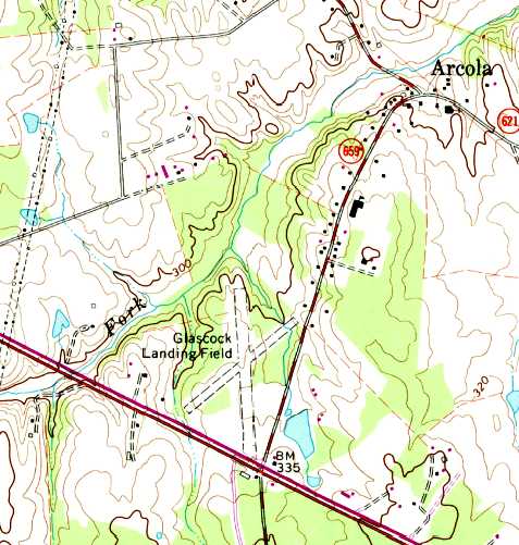
The 1968 USGS topo map depicted “Glascock Landing Field” as having 2 unpaved runways.
A 1969 aerial view did not show any significant differences from the 1965 photo.
A 3/26/72 USGS aerial photo (courtesy of Dallam Oliver-Lee) appeared to depict Glascock Airport with the largest number of aircraft seen in photos of the field,
with 5 or 6 light aircraft parked on the south end.
A closeup of a 1974 aerial photo depicted Glascock Airport showed a total of 4 light aircraft parked on the south side.
The 2 small hangars previously seen at the southeast corner had been removed,
but the individual T-hangar remained on the opposite side of the runway.
The February 1975 Washington Terminal Aeronautical Chart (courtesy of Mitchell Hymowitz).
depicted Glascock as a public-use airport having a 2,600' unpaved runway.
A 1979 aerial view showed that the popularity of Glascock Airport had waned -
there were no longer any aircraft visible on the field,
but the individual T-hangar remained standing on the southwest side of Runway 36.
The September 1981 Washington Terminal Aeronautical Chart (courtesy of Ron Plante)
continued to depict Glascock as a public-use airport having a 2,600' unpaved runway.
A 1981 aerial view did not show any significant differences from the 1979 photo.
In the mid 1980s, a number of ultralight aircraft were based at Glascock,
but the increased air traffic at nearby Dulles International Airport forced their operations to be discontinued.
Glascock is located a mere 2 miles from the end of Dulles International Airport's Runway 30,
well within the inner ring of Dulles' Class B airspace, which makes use of the field a bit of an issue.
The 1990 USGS topo map depicted “Glascock Landing Field” as having 2 unpaved runways.
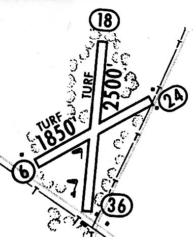
A 1994 airport directory (courtesy of Gwen Shafer) depicted Glascock Field as having 2 turf runways: 2,500' Runway 18/36 & 1,850' Runway 6/24,
but indicated that Runway 6/24 was unusable.
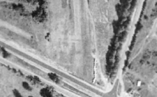
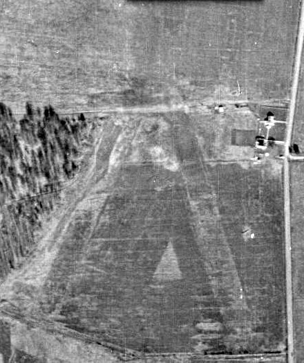
A 1995 USGS aerial view looking west at Glascock Field, with its sole Cessna 150 visible at the southeast end (bottom-left).
As of 1997, Glascock Field was still owned by Delmas Glascock (who was 89 at the time), and managed by his son, Thomas.
Delmas & Thomas Glascock were to be commended for keeping this little slice of VA aviation history alive,
and not allowing it to be converted into yet another development of townhouses.
According to an article by Lynn Wolstenholme in the 1/2/08 issue of the Loudoun Times-Mirror,
airport founder Delmas Glascock passed away in 1999.
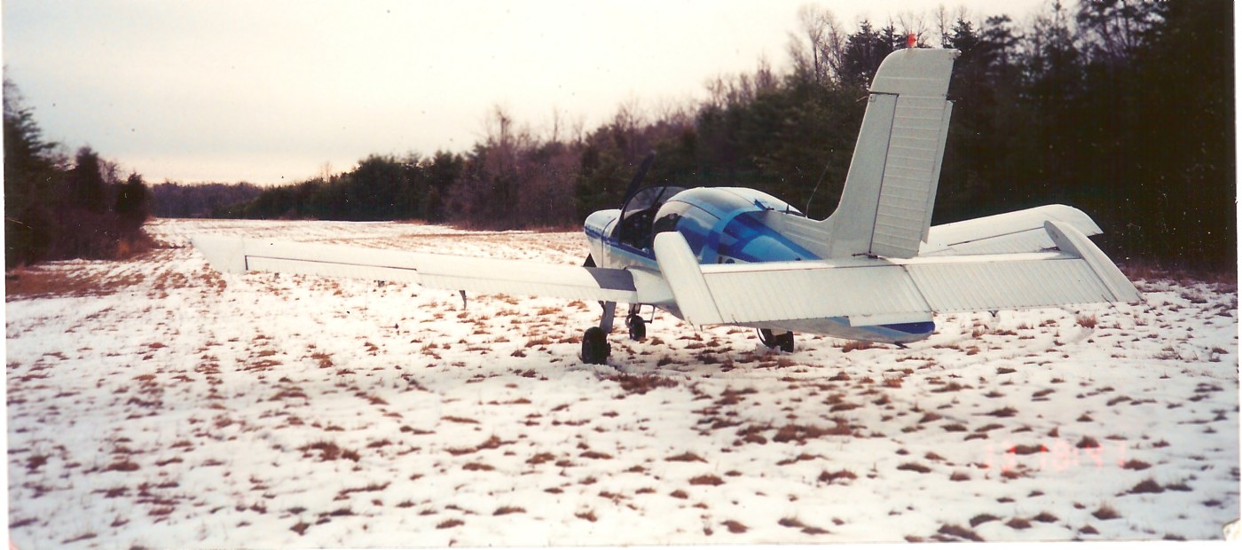
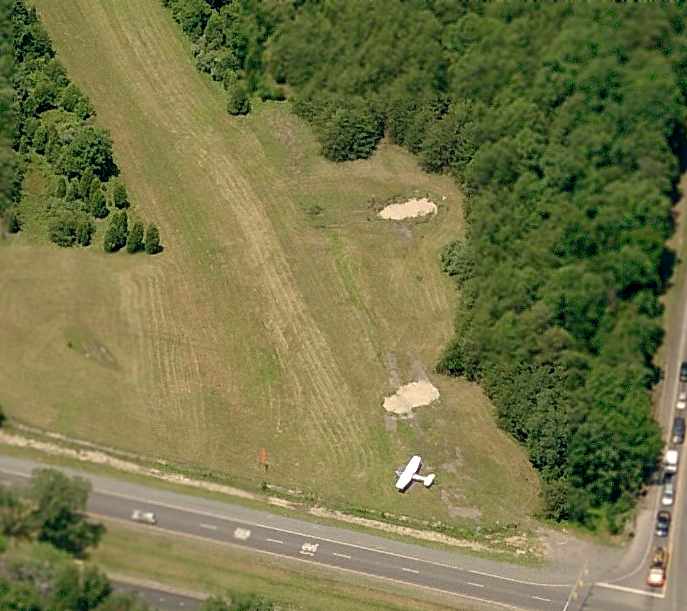
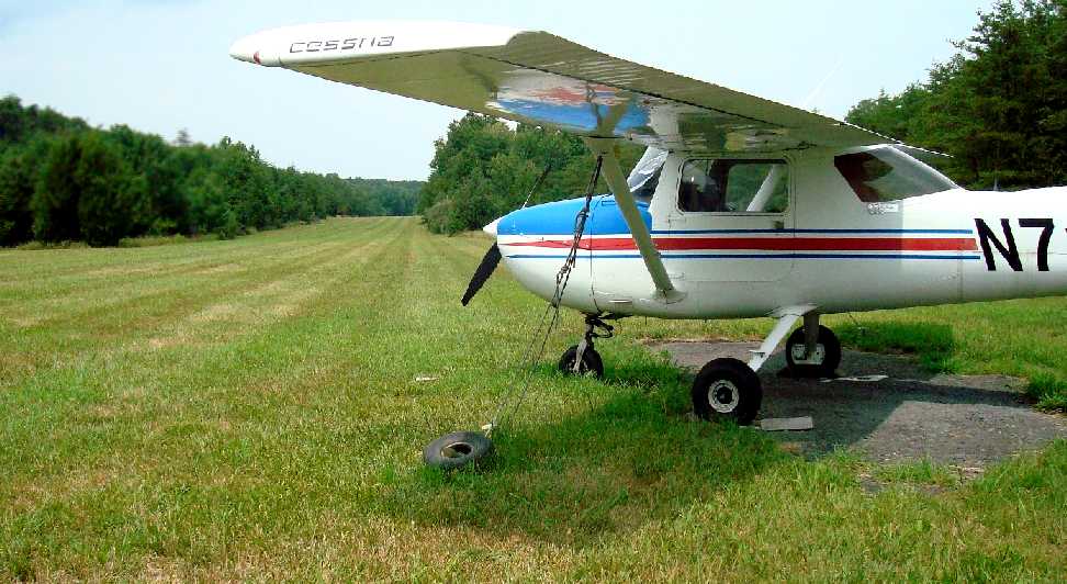
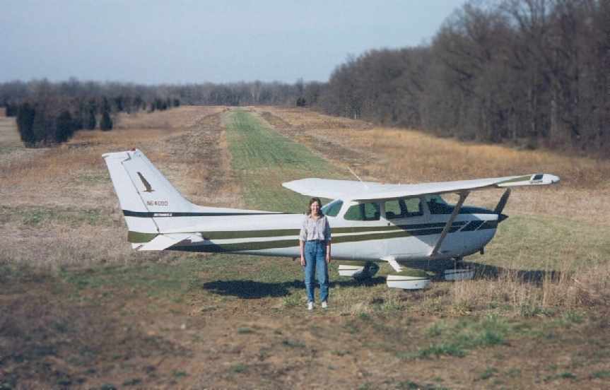
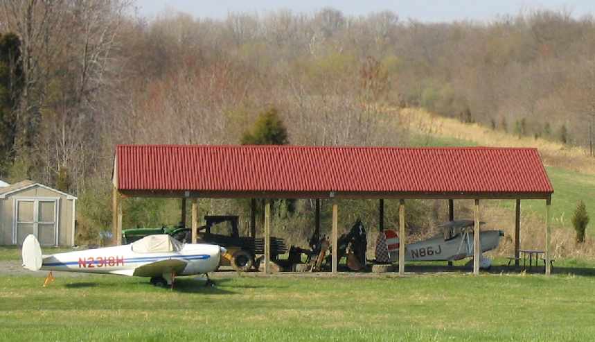
An early 1999 photo by Michael Strutzel of N61BF, his 1972 Socata MS894A Ralleye, “before departing on Runway 18 after a light snowfall. Off to the right was a hunter’s deer stand.
I bought the windsock shown in several photos when my airplane was based there & tied down a few hundred feet north of the Cessna 150 at Runway 18/36’s south end.
The white blocks in several photos looking north on Runway 36, past the Cessna 150, were rather uneven concrete tie-downs.
I recall using sometimes the east side of Runway 6/14’s intersection with Runway 18/36.
Around 8 planes back then were listed on Dulles Control Tower’s letter of authorization (LoA) allowing entry/departure in the Class B’s first ring (which begins at surface)
without Class B clearance or tower contact IF staying <1,400’ from/to the airport’s southwest.
Which I once had to explain to a questioning Dulles controller after being asked to call upon arrival at Manassass.
I moved the Rallye to Manassas by summer 1999 for annual/maintenance & stayed.”
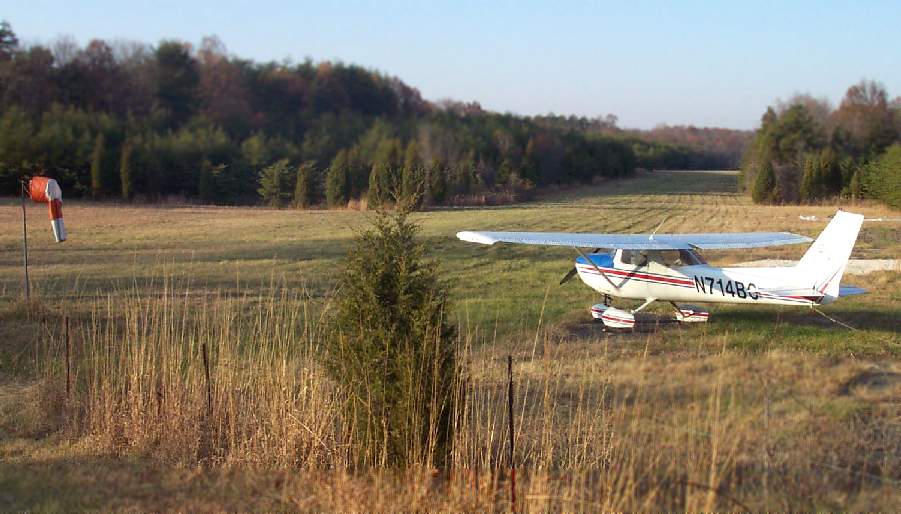
A 2001 photo by Paul Freeman looking north at the sole aircraft based at Glascock,
a Cessna 150 parked at the approach end of Runway 36.
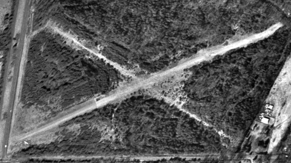
A 2002 USGS aerial view of Glascock Field, with its sole Cessna 150 visible at the south end.
Runway 18/36 was still well-maintained, but the former crosswind Runway 6/24 was progressively narrowed by trees,
and the former taxiway connecting the southern end of the 2 runways had completely overgrown.
As of 2003, Glascock Field was still listed as an active private airfield,
with 2 grass runways, the longest of which was 2,500' Runway 18/36.
A 2004 aerial view looking northeast at Glascock Field by Patrick Hendrickson of Highcamera.com aerial photography.
As of early 2004, the only aircraft on the field was a Cessna 150 (owned by retired USAF Col. Howard Junkermann),
tied down on the south end of Runway 36, only a few feet from Route 50.
According to an article by Lynn Wolstenholme in the 1/2/08 issue of the Loudoun Times-Mirror,
residential developer Van Metre purchased the Glascock Airport property in 2005.
However the airport continued to operate for a few more years.
Nearby resident Mike Rhodes reported in 2005, “The field is still maintained
and I believe the 150 (N714BG) is the sole plane still based there.
I have recently seen someone there working on it
and at times it isn't there so I can only assume it is still active.”
Stephanie Sperling (of Thunderbird Archeology) reported in 2005
that she is “conducting a Phase I archaeological survey on the Glascock property.
I plan on filing the airfield with the Virginia Department of Historic Resources.”
A circa 2006 aerial view looking north at the Cessna 150 still tied up at the south end of Glascock Field.
As of 2007, Glascock was the closest-in private airfield which remained in use in the Northern Virginia suburbs of Washington.
Unfortunately the end appeared to have come for Glascock Airport in 2007.
An article on the front page of the 12/5/07 issue of the Loudoun Times-Mirror was entitled “Two rezonings OK'd”.
It reported that “The Glascock Field at Stone Ridge” application to rezone the Glascock Field property had been approved,
and thus would permit the construction of 276 multifamily dwelling units & 1,310,355 square feet of office space.
The applicant was Glascock Field at Stone Ridge LLC (formerly known as Stone Ridge Community Development III LCC).
This action to rezone the property was somewhat predictable,
as a majority of the pro-development Loudoun County Board of Supervisors had been voted out of office only the month before,
yet the local press reported that the outgoing Board had a number of rezoning applications under its consideration before its term was up.
True to form, ignoring the wishes of the voters (who had replaced them with a slate of new board members opposed to further development),
the lame-duck Board members took advantage of the situation to repay their development-industry campaign contributors.
According to an article by Lynn Wolstenholme in the 1/2/08 issue of the Loudoun Times-Mirror,
the sole remaining plane based at Glascock Field was the Cessna 150 owned by 89 year old Fairfax resident Howard Junkerman.
Howard reported, “I use the field & go up for leisure & travel.”
According to the Loudoun Times-Mirror article, “Eventually the landing strip will be surrounded by 276 homes,
a more than 1-million square foot office park & a hospice center with 2 heliport pads.
Loudoun's Board of Supervisors recently approved Van Metre's rezoning application for the property.”
However, the contention that the Glascock Airport property will be used for a “hospice center” is is contradicted by HCA Healthcare on their website,
in which they say “HCA Virginia today announced plans to develop a new medical campus
on 49 acres of land it has acquired on Route 50 in southern Loudoun County.
HCA Virginia’s 49-acre site is located at the intersection of Route 50 & Gum Spring Road, and adjacent to Glascock Field, an airplane landing strip.
The land is currently undeveloped & is already zoned for outpatient medical facility use.
We plan to develop the property in 2 phases - first, by providing outpatient services, and later by building a hospital.”
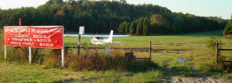
What a sad sight – a 2008 photo by Paul Freeman looking northwest at the Cessna 150 at a beautiful grass landing strip,
but with a sign announcing what the property will shortly become – yet another development of houses.
Pretty soon we can expect to see all of Loudoun County covered up with pavement & townhouses –
what a great quality of life that will bring for future generations.
Heaven forbid we & our elected officials would have preserved a reasonable proportion of greenspace.
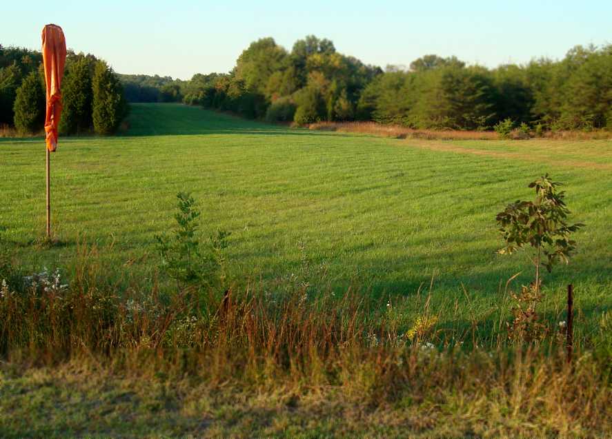
A 2008 photo by Paul Freeman looking north along the Glascock runway, with the windsock in the foreground.
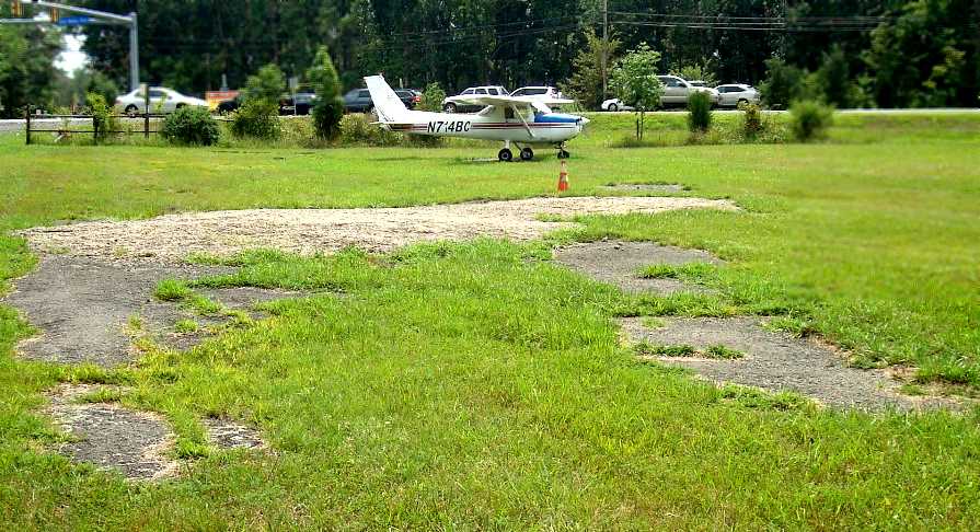
A 2008 photo by Paul Freeman looking northeast at the Cessna 150 parked at Glascock.
What appears to be another asphalt pad (or foundation) sits just north of the Cessna.
The February 2009 Washington Terminal Area Chart depicted Glascock as a private airfield having a 2,500' unpaved runway.
The last aeronautical chart depiction which has been located of Glascock Field was on the 2010 Washington Sectional Chart (courtesy of Jonathan Westerling).
It depicted Glascock as a private airfield having a 2,500' unpaved runway.
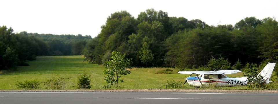
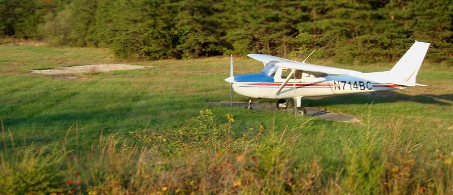
A 7/18/10 photo by Paul Freeman looking north along Glascock's Runway 36, with Cessna 150 N714BC looking ready to go.
An August 2011 photo by Paul Freeman looking north along Glascock's Runway 36.
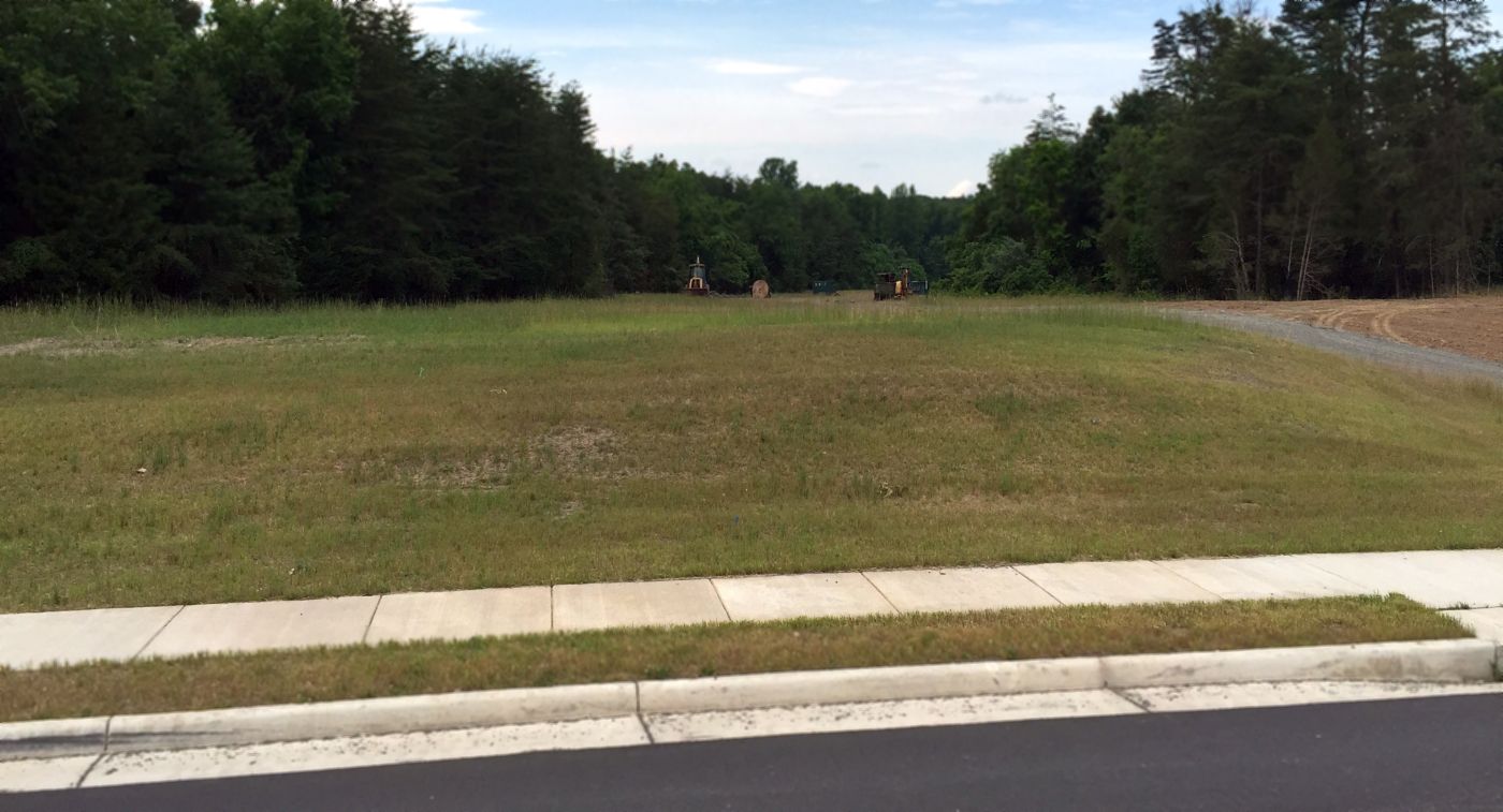
This enigmatic small airfield only a few miles from the Washington beltway remains intact, for now!
The grass is neatly trimmed, and Cessna 150 N714BC appears ready to go.
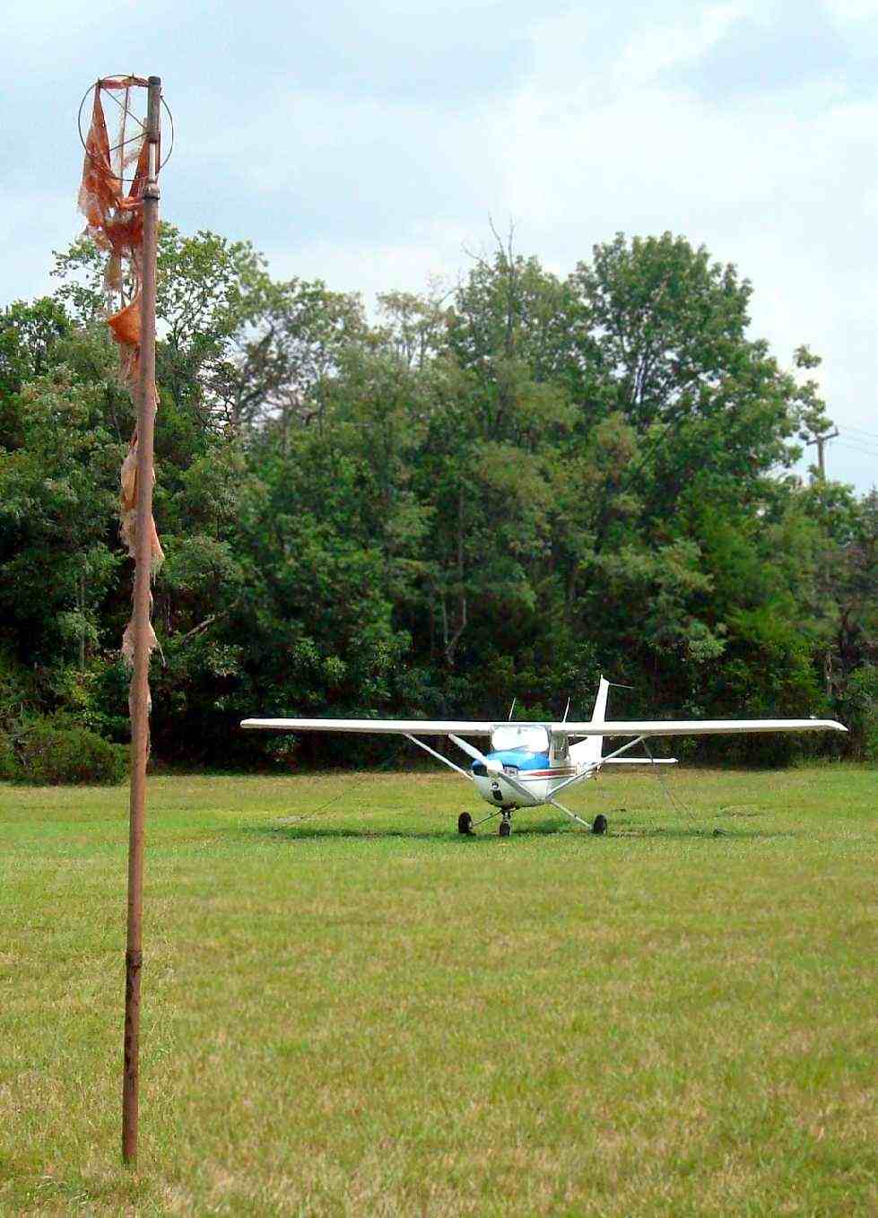
An August 2011 photo by Paul Freeman looking east at Glascock's windsock, looking remarkably tattered compared to 2008.
An August 2011 photo by Paul Freeman looking southeast at what appears to be an asphalt pad (or foundation) just north of the Cessna.
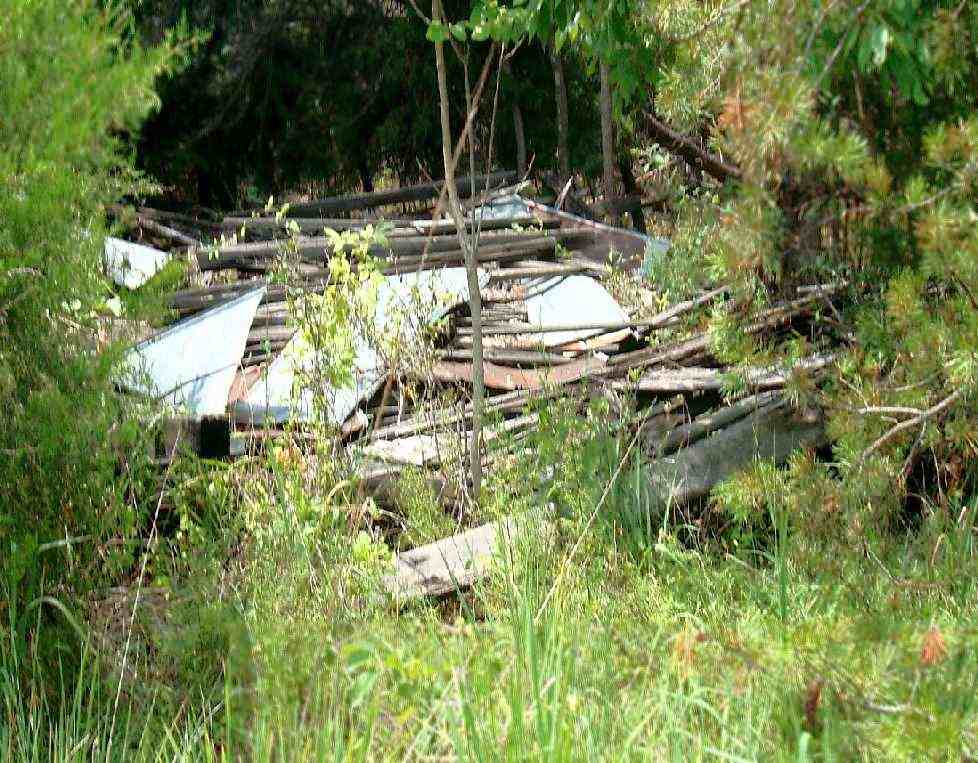
An August 2011 photo by Paul Freeman looking west at debris just inside the treeline on the southwest side of Glascock Field.
This is presumably the remains of the T-hangar seen in the 1974 aerial photo.
Paul Freeman drove by Glascock Field on 10/14/11 & was surprised to see the little Cessna gone, for the first time in years,
and 2 weeks later the field was still empty.
So it appeared perhaps the end had finally come for Glascock Field.
However, apparently this little airfield truly has nine lives,
because Richard Willett reported shortly thereafter, “I drove by Glascock field yesterday [11/22/11] and the Cessna 150 is back!”
The last photo which has been located showing an aircraft at Glascock Field was a 2012 aerial view, which showed the Cessna 150 still parked on the southeast corner.
Unfortunately, Glascock Field's amazing run finally came to an end after 71 years.
Dave Schubert reported on 8/1/12, “After all these years, 98VA - Glascock Airport appears to finally be done.
The lone aircraft N714BC flew out about 2 weeks ago, days ahead of the heavy equipment rolling in.
Heavy equipment was positioned last week at the south end of the airport nearest US Route 50.
Now the equipment has moved to the north end of the runway to begin construction of a new senior citizen community, according to my sources.”
An 8/1/12 photo by Dave Schubert – a sad sight looking northwest along Glascock Field,
showing the former parking area of Glascock's last based aircraft now being prepared for redevelopment.
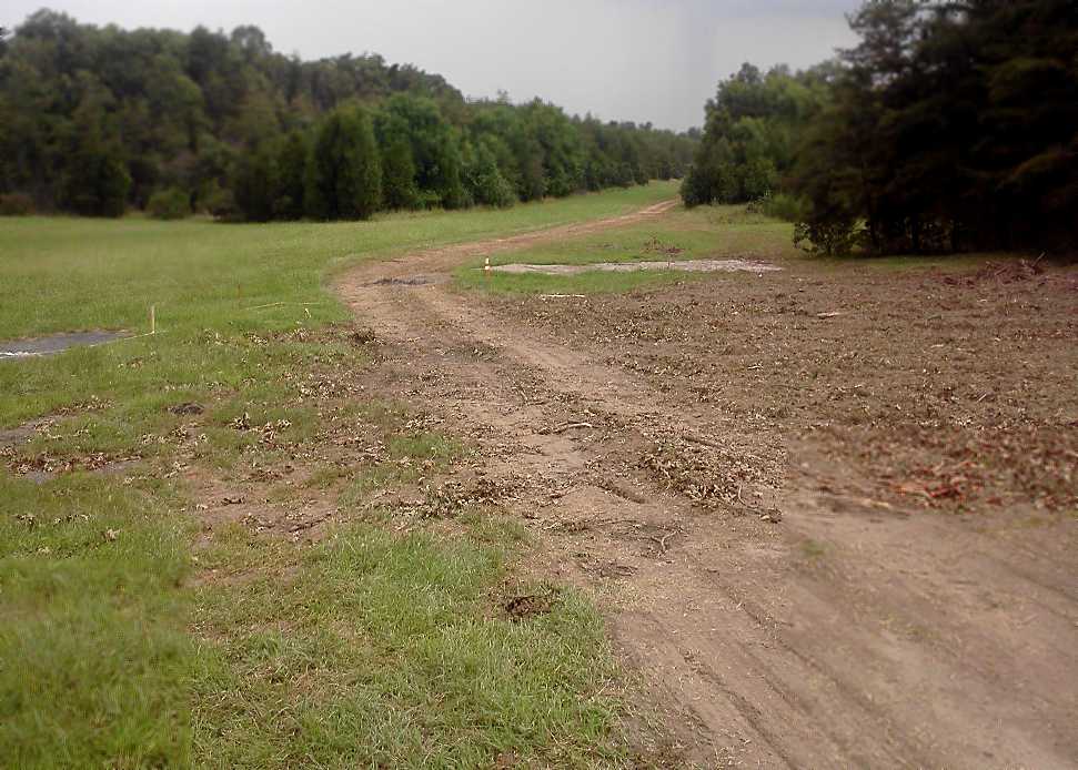
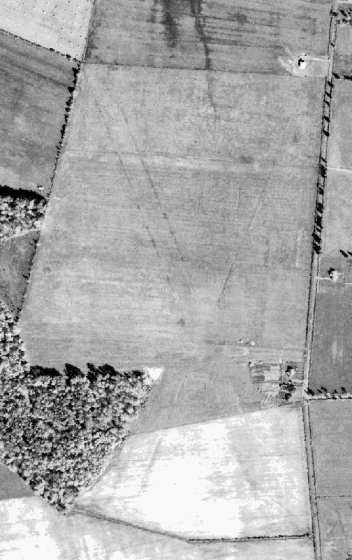
A 10/12/12 aerial view showed construction equipment parked along the north end of Glascock's runway,
and a new path having been cut through the property toward the northwest.
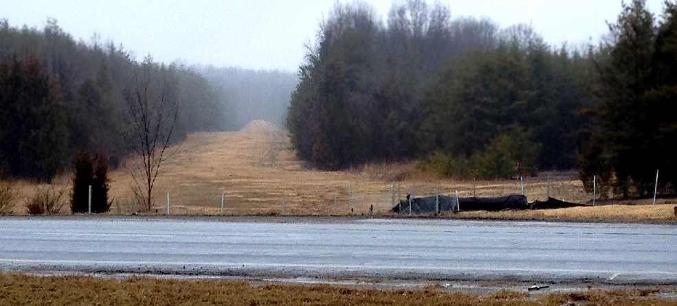
Perhaps the last view seen of a relatively undisturbed Glascock Field: a 2/23/13 photo by Paul Freeman looking north along Glascock's Runway 36,
with its former Cessna already gone, but the runway otherwise remaining intact, at least for a short while.
A chapter in Loudoun County aviation came to an end.
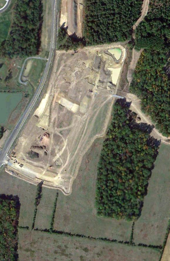
An August 2014 visit to the site of Glascock Field showed the StoneSprings Hospital under construction on the south end of the Glascock Field site.
The last remaining trace was the northern end of Runway 18, which extended toward the north away from a newly-constructed road which bisected the former runway.
A 6/13/15 photo by Paul Freeman looking north from the new Stonesprings Boulevard which bisects Glascock Field,
showing the last remaining trace (for a little while) of the little airport: the northern portion of the former Runway 36.
Glascock Field was no longer depicted on the 2016 Washington Sectional Chart.
A 2020 aerial view looking west, showing Stonesprings Hospital & other buildings having covered most portions of the Glascock Field site.
However, Logan Reuter pointed out that portions of the northwest end of Runway 18 remain clear (the diagonal path running from top-right).
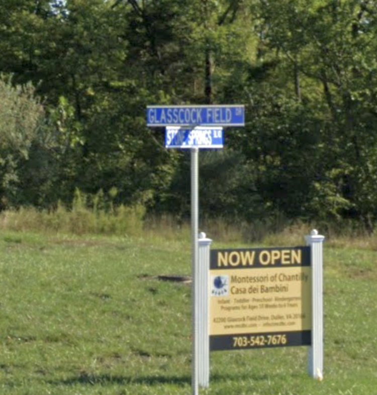
A 2021 photo (courtesy of Logan Reuter) shows that a clue to the history of the Glascock Field site has been preserved via the name of a road built over the northwestern portion, unfortunately misspelled “Glasscock Field Drive”.
The site of Glascock Field is located on the northwest corner of the intersection of Route 50 & Gum Spring Road.
See also: "History of Glascock Airfield" by Howard Junkermann, at the Leesburg Balch Library.
____________________________________________________
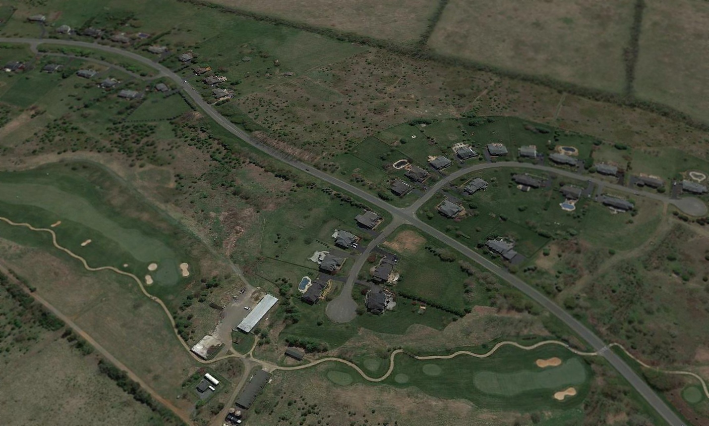
Strobel Airfield, South Riding, VA
38.92, -77.53 (Northwest of Washington, DC)
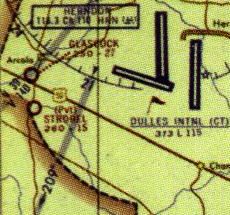
Strobel Airfield, as depicted on the September 1965 Washington Local Aeronautical Chart.
Photo of the airfield while in use has not been located.
This small private airfield located a mere 2 miles southwest of Dulles International Airport
may have been established at some point in 1965,
as it was not yet depicted on the 1961 USGS topo map or the April 1965 Washington Local Aeronautical Chart.
The earliest depiction which has been located of Strobel Airfield was on the September 1965 Washington Local Aeronautical Chart,
which depicted Strobel as a private airfield with a 1,500' unpaved runway.
The only topo map depiction which has been located of Strobel Airfield was on the 1969 USGFS topo map.
The February 1975 Washington Terminal Aeronautical Chart (courtesy of Mitchell Hymowitz)
depicted Strobel as a private airfield having a 1,500' unpaved runway.
Strobel Airfield was evidently closed (for reasons unknown) at some point between 1975-76,
as it was no longer depicted on the 1976 Washington Sectional Chart.
A 1989 USGS aerial photo did not show any recognizable trace of an airfield at the general location of Strobel Airfield,
with several farm fields in the viscinity.
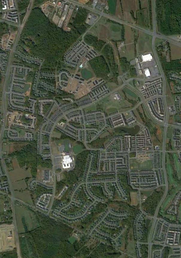
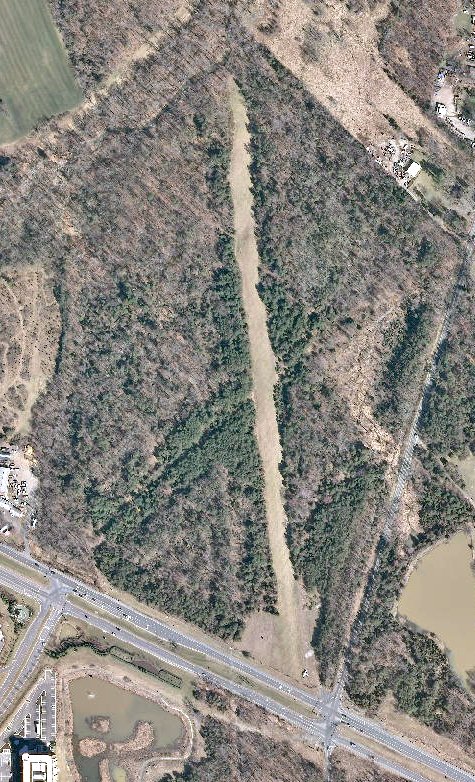
A 2012 aerial view showed the new community of South Riding covering the site of Strobel Airfield.
The site of Strobel Airfield is located southeast of the intersection of Route 50 & Gum Spring Road.
Thanks to Dennis Boykin for pointing out this airfield.
____________________________________________________
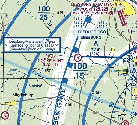
Coonskin Farm Airfield / Goose Hunt Farm Airfield (3VA5), Aldie, VA
39.028, -77.625 (Northwest of Washington, DC)
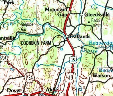
Coonskin Farm Airfield, as depicted on the 1989 USGS topo map.
Photo of the airfield while in use has not been located.
This small private airfield in Central Loudoun County may have been established at some point between 1984-89,
as it was not yet depicted on the September 1981 Washington Terminal Aeronautical Chart (courtesy of Ron Plante)
nor on the 1984 USGS topo map.
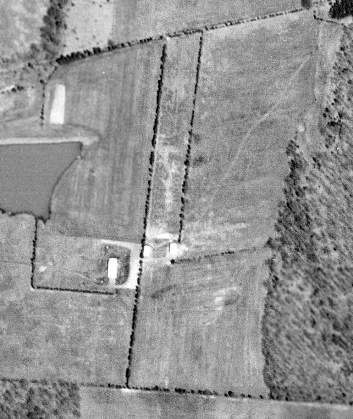
A 1988 aerial photo showed an open field, without any recognizable trace of an airfield.
The earliest depiction which has been located of Coonskin Farm Airfield was on the 1989 USGS topo map.
Coonskin Farm Airfield may have been very short-lived, as it was not depicted on the 1991 Washington Sectional Chart.
In 2008 the airfield was evidently reestablished as Goose Hunt Farm Airfield,
as January 2008 is listed as the activation date of Goose Hunt Farm Airfield in the FAA Airfield/Directory data.
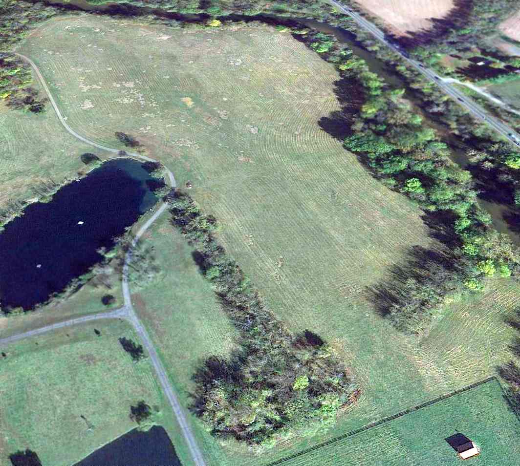
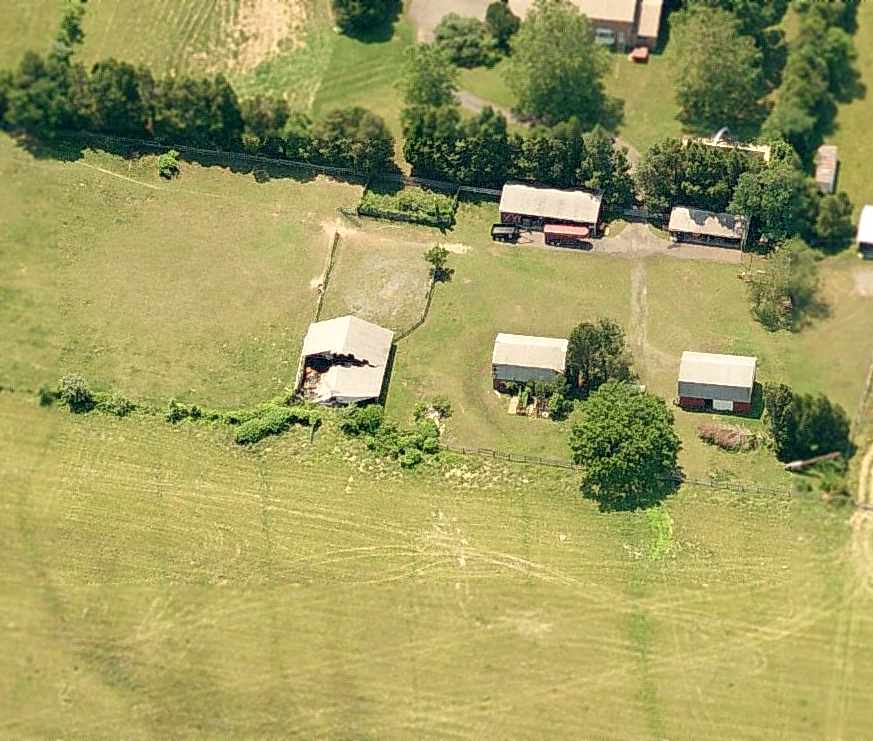
A 2013 aerial view looking north showed a clearing through the trees along the orientation of Goose Hunt Farm Airfield's Runway 17/35.
But there were no aircraft visible or any other recognizable trace of an airfield.
The 2014 Washington Terminal Aeronautical Chart depicted Goose Hunt as a private airfield having a 1,700' unpaved runway.
As of 2014, the FAA Airfield/Directory data described Goose Hunt Airfield
as having a 1,700' turf Runway 17/35, and listed the owner & manager as Neal Nichols.
Dennis Boykin reported in 2014, “Goose Hunt is still listed in the FAA database,
but according to local rumor, it was sold a few years back & the new owners put a fence across it for a horse corral.”
The site of Goose Hunt Airfield is located northwest of the intersection of Route 15 & Oatlands Road.
Thanks to Dennis Boykin for pointing out this airfield.
____________________________________________________
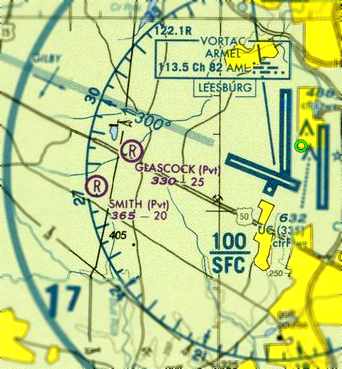
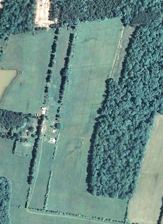
Smith Airport (VG23), Arcola, VA
38.928, -77.563 (Northwest of Dulles Airport, VA)
Smith Airport, as depicted on a 4/13/69 USGS aerial photo (courtesy of Dallam Oliver-Lee).
Smith Airport was a private airfield in what eventually became the fast-growing Northern Virginia suburbs.
A 3/27/65 USGS aerial photo showed the distinctive outline of this north/south grass runway, but did not yet depict any buildings.
The earliest depiction which has been located showing buildings on Smith Airport
was a 4/13/69 USGS aerial photo (courtesy of Dallam Oliver-Lee).
It depicted a total of 3 buildings along the midpoint of the grass runway.
Smith Airport was not yet depicted on the 1970 Washington Sectional Chart (courtesy of Clark Clifford).
According to the FAA Airport/Facility Directory, Smith Airport had an “Activation date” of August 1973.
The earliest aeronautical chart depiction which has been located of Smith Airport
was on the February 1975 Washington Terminal Aeronautical Chart (courtesy of Mitchell Hymowitz).
It depicted Smith as a private airfield having a 2,000' unpaved runway.
Note Smith Airport's proximity to the massive Dulles International Airport a mere 4 miles to the northeast.
Smith Airport was not depicted at all on USGS topo maps from the 1970s or 1980s,
presumably overlooked due to its small size.
The last photo which has been located showing Smith Airport completely intact was a 5/6/06 USDA aerial photo (courtesy of Dallam Oliver-Lee).
It depicted a total of 3 buildings along the midpoint of the grass runway,
but did not depict any aircraft.
A circa 2006-2008 aerial view looking west unfortunately showed the hangar along the Smith runway with considerable roof damage,
and no sign of recent aviation use.
A 12/31/08 VA State aerial photo (courtesy of Dallam Oliver-Lee)
showed that all 3 buildings along the midpoint of the grass runway had been removed.
The August 2007 Washington Terminal Area Chart depicted Smith as a private airfield having a 2,000' unpaved runway.
The last photo which has been located showing Smith Airport still somewhat intact
was a 6/20/11 USDA aerial view (courtesy of Dallam Oliver-Lee).
The runway remained intact, but all of the airfield buildings had been removed..
According to its last entry in the FAA Airport/Facility Directory,
Smith Airport was owned by Clarence Smith & had a single 1,975' turf Runway 1/19.
The end finally came for Smith Airport at some point between 2011-2012, as a 10/12/12 aerial view (courtesy of Dallam Oliver-Lee)
showed the property had been scraped clean in preparation for new construction,
ending the history of this obscure Loudoun County airport.
Oddly, the 2013 Washington Terminal Area Chart continued to depict Smith as a private airfield having a 2,000' unpaved runway,
even though it had ceased to exist in the previous year.
This is a significant safety hazard for the FAA to continue to depict an airfield which in reality now has houses covering the site.
The site of Smith Airport is located northwest of the intersection of Northstar Boulevard & Mattingly Drive.
____________________________________________________
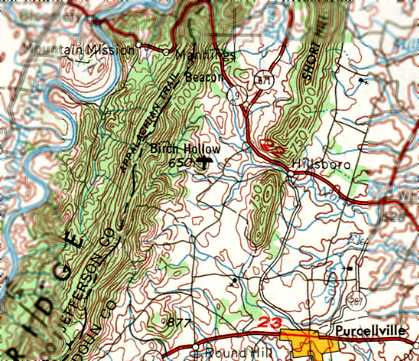
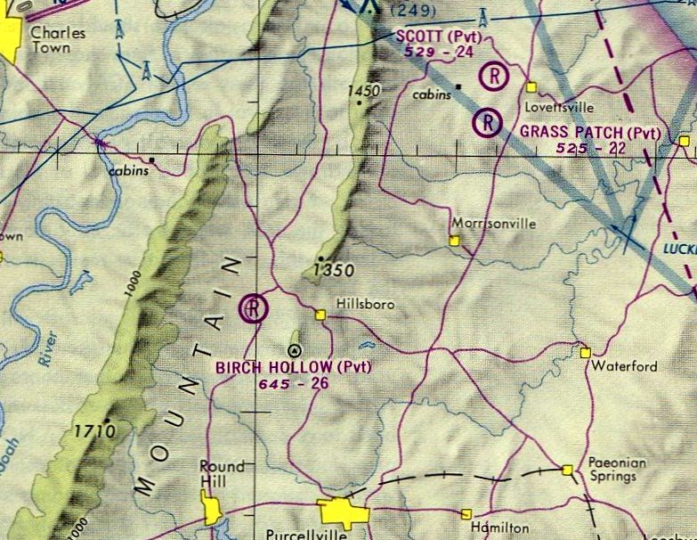
Birch Hollow Airfield, Hillsboro, VA
39.202, -77.76 (Northwest of Dulles Airport, VA)
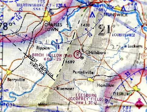
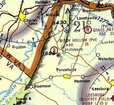
Birch Hollow Airfield, as depicted on the April 1969 Washington Sectional Chart (courtesy of Chris Kennedy).
This short-lived private airfield in the Virginia horse country was evidently built at some point between 1967-69,
as it was not yet depicted at all on a 1957 aerial photo nor on the March 1967 Washington Sectional Chart.
The earliest depiction which has been located of the Birch Hollow Airfield
was on the April 1969 Washington Sectional Chart (courtesy of Chris Kennedy).
It depicted Birch Hollow as a private field having a 2,600' unpaved runway.
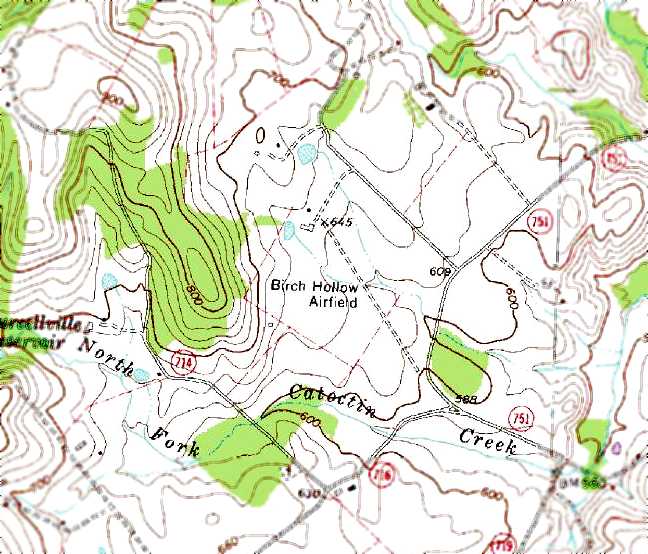
Birch Hollow Airfield, as depicted on the 1969 USGS topo map.
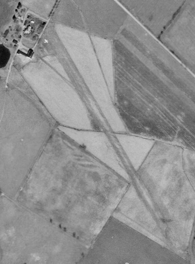
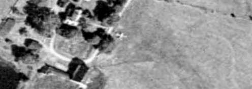
The earliest photo which has been located showing the Birch Hollow Airfield was a 4/19/69 aerial view.
It depicted the field as having a single grass northwest/southeast runway, with one single-engine plane parked next to the buildings at the northwest end.
Kevin Hynes recalled, “When we lived near Hillsboro in Birch Hollow Hamlet,
we were told that the original farm (Birch Hollow Farm) had a private airfield.
The farm was owned by Durette Upton; I believe her husband was the owner of the airfield.”
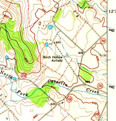
The 1970 USGS topo map depicted the Birch Hollow Airfield as having a single unpaved northwest/southeast runway.
The 1971 Washington Sectional Chart (courtesy of Ed Francis)
depicted Birch Hollow as a private field having a 2,600' unpaved runway.
The last photo which has been located showing the Birch Hollow Airfield while it was in use was a 1974 aerial view.
It depicted one single-engine plane parked next to the buildings at the northwest end of the Birch Hollow runway.
The last aeronautical chart depiction which has been located of Birch Hollow Airfield
was on the February 1975 Washington Terminal Aeronautical Chart (courtesy of Mitchell Hymowitz).
It depicted Birch Hollow as a private field having a 2,600' unpaved runway.
Birch Hollow Airfield evidently was open for less than a decade,
and was closed (for reasons unknown) at some point between 1975-77,
as it was no longer depicted on the 1977 Washington Sectional Chart (according to Chris Kennedy)
or subsequent charts.
The 1981 USGS topo map depicted the Birch Hollow Airfield as having a single unpaved northwest/southeast runway.
The last map depiction which has been located of Birch Hollow Airfield was on the 1984 USGS topo map.
The last photo which has been located still showing the Birch Hollow runway remaining intact was the 1989 USGS aerial view,
but there was no sign of any recent aviation usage.
From 1993-96, the Birch Hollow Farm property was redeveloped into the Birch Hollow Hamlet, a development of 21 houses.
An August 24, 2007 aerial view showed that the site of Birch Hollow Airfield after it had been redeveloped with housing.
The northwest/southeast alignment of the former runway was still apparent,
but several ponds & a road had been built over the site of the runway.
The site of Birch Hollow Airfield is located west of the intersection of Birch Hollow Lane & Cider Mill Road.
Thanks to Kevin Hynes for pointing out this airfield.
____________________________________________________
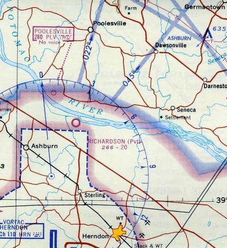
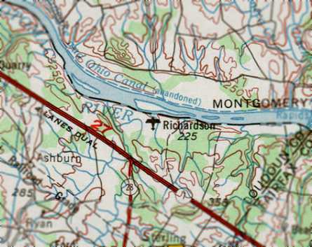
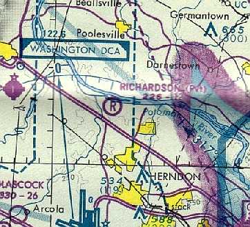
Richardson Field, Broad Run Farms, VA
39.062, -77.432 (North of Dulles Airport, VA)
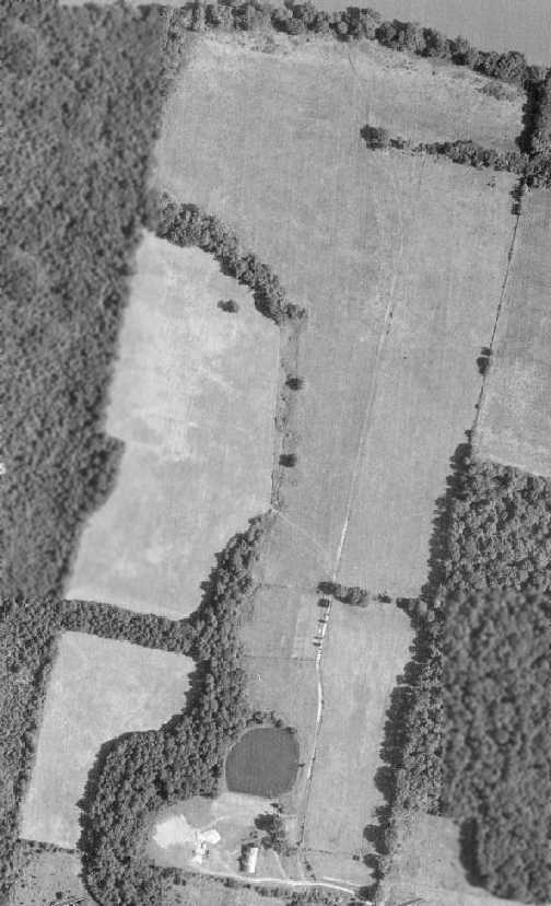
A 1963 aerial view depicted the Richardson Airfield as having a single grass northeast/southwest runway,
with a single Cessna parked next to the southwest runway end.
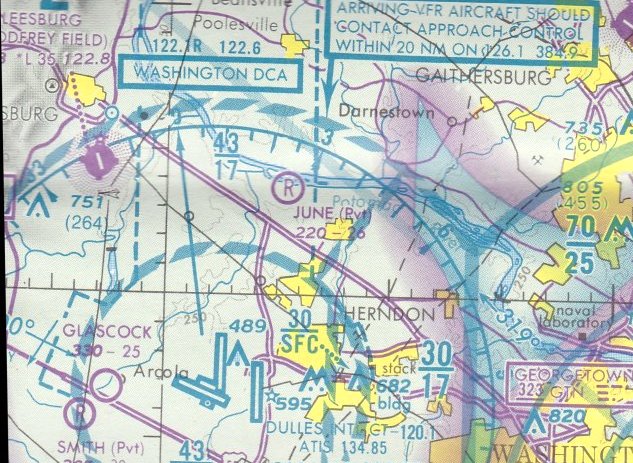
Richardson Field was one of 2 small private grass airfields located in close proximity to each other (June Field being the other),
in what is today a densely developed Northern Virginia suburb.
Richardson Field was apparently built at some point between 1957-63, as it was not yet depicted at all on a 1957 aerial photo.
The earliest depiction which has been located of the Richardson Airfield was a 1963 aerial photo.
It depicted the field as having a single grass northeast/southwest runway,
with a single Cessna parked next to the southwest runway end.
Richardson Field was not yet depicted on the 1963 USGS topo map.
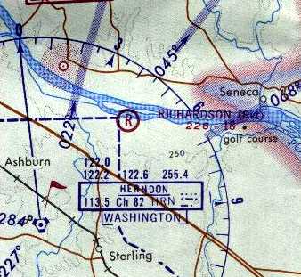
The earliest aeronautical chart depiction which has been located of Richardson Field
was on the 1964 Washington Sectional Chart (courtesy of John Voss).
It described the field as having a single 2,000' turf strip, with the remark "Center of runway often under water."
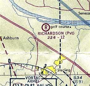
The last aeronautical chart depiction which has been located of Richardson Field in its original Broad Run Farms location
was on the April 1965 Washington Local Visual Aeronautical Chart (courtesy of John Ferrara).
It depicted Richardson as a private field with a 2,000' unpaved runway.
The 1968 USGS topo map did not depict Richardson Field.
The 1969 USGS topo map depicted Richardson Field.
A Sterling resident recalled, “When I was in the 7th grade in 1970, kids talked about the airstrip in Broad Run Farms.
The middle would end up under water because it was a low spot.”
In a 1970 aerial view, the distinct runway seen in the 1963 aerial view was gone,
with an oval-shaped course covering part of the northern site of the runway.
However, the 1970 Washington Sectional Chart continued to depict Richardson Field
as a private field with an 1,800' unpaved runway.
A 1974 aerial view showed that the use of the property for aviation had definitely ended,
as trees had grown along various parts of the former runway.
The 1975 Washington Local Aeronautical Chart (courtesy of Ed Drury) appeared to depict Richardson Field
in a location somewhat further east, which would correspond to the location of June Field instead.
This discrepancy has not been explained. Was Richardson Field relocated to the eventual location of June Field?
The last aeronautical chart depiction which has been located of Richardson Field
was on the July 1976 Washington Local Aeronautical Chart.
It depicted Richardson as a private airfield with a 1,200' unpaved runway.
Richardson Field was evidently abandoned at some point between 1976-81,
as it was no longer depicted on the September 1981 Washington Terminal Aeronautical Chart (courtesy of Ron Plante).

A 2018 aerial view shows that the site of Richardson Field is now unrecognizable as ever having been an airfield.
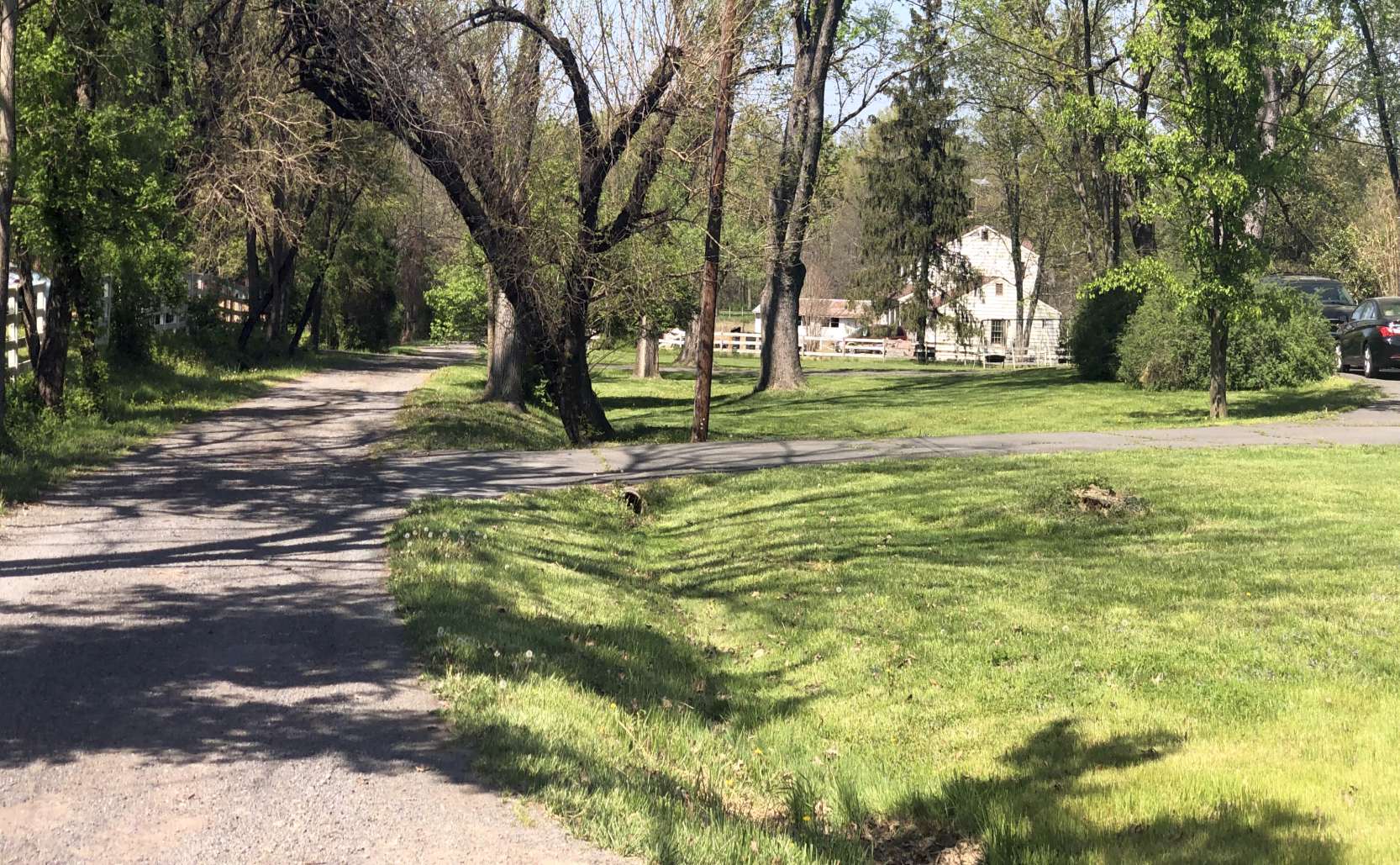
A 4/24/22 photo by Paul Freeman looking north along Bobwhite Lane, showing no trace of Richardson Field.
The site of Richardson Field is located north of the intersection of Dairy Lane & Bobwhite Lane.
____________________________________________________
39.062, -77.415 (North of Dulles Airport, VA)
A 1970 aerial view did not yet depict any specific signs of June Field.
June Field was one of 2 small private grass airfields located in close proximity to each other (Richardson Field being the other),
in what is today a densely developed Northern Virginia suburb.
The 1969 USGS topo map did not depict June Field,
nor did 1970 or 1974 aerial views depict any specific signs of an airfield.
According to the current property owner, Arlin Raney bought the property around 1975.
His original plans included a seaport on the river & 2 runways.
He submitted the proper paperwork with the FAA & started construction.
The airfield was named after his girlfriend at the time.
He did not get a permit form the county, and ran into trouble down the pike when the Countryside development was being built.
He had a very adversarial relationship with the developer of Countryside.
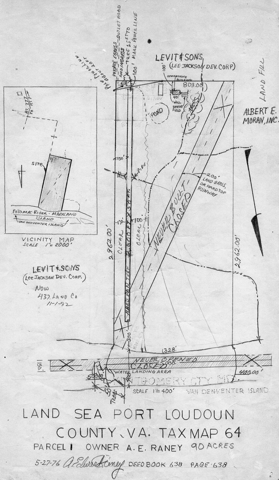
A 5/27/76 Loudoun County Tax Map depicted June Field under the generic name “Land Sea Port”.
It was said to comprise 90 acres, owned by A.E. Raney.
It depicted a 2,600' “hard pan turf” north/south runway, with an Operations Building & a few other small buildings to the southwest.
A “never built” southwest/northeast grass or hardtop runway was also depicted,
along with a “never opened” 5,000' east/west water landing area in the Potomac River to the north.
Mark Williamson recalled, “I spent a couple of days (in 1978) working for the guy who used to own that land.
He was a retired airline pilot & was building a house with the hopes of also building a runway.”
A 1979 aerial view did not show any aircraft on the field.
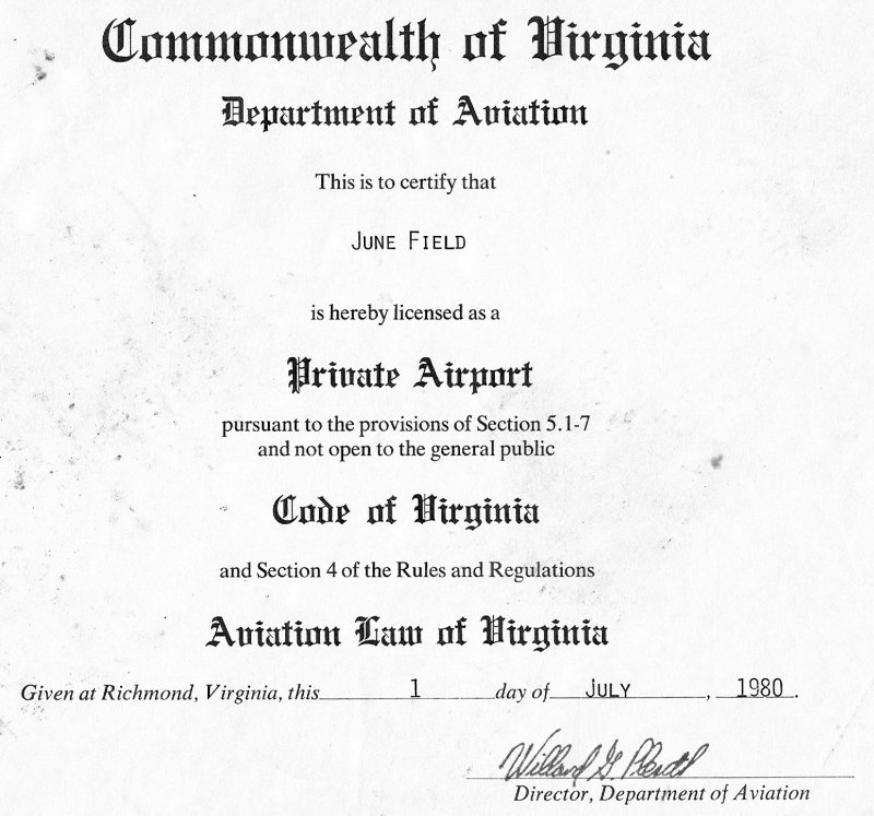
A 7/1/80 VA Department of Aviation Private Airport License for June Field.
The September 1981 Washington Terminal Aeronautical Chart (courtesy of Ron Plante) & March 1982 Washington Sectional Charts did not yet depict June Field.
According to the current property owner, Arlin Raney did get a special exception from the county (in 1983) to operate a private airstrip.
Originally, the runway was 40' wide & had an additional 100' cleared on either side.
There are power lines on the south end.
His exception required no southern departures or northern approaches (due to the homes).
Raney had a fleet tied down at the south end of the strip,
including a Stearman, Decathlon, Aero Commander, Smith Mini, Ercoupe, Cessna 172, and a 337.
The earliest photo which has been located showing aircraft at June Field was a 7/8/83 aerial view.
A total of 3 aircraft were visible to the southwest of the runway.
According to the current property owner, the encroaching development & continual harassment by the developer drove Arlin Raney away.
One day in late 1984 he ferried out all his aircraft.

The earliest map depiction which has been located of June Field was on the 1984 USGS topo map.
The earliest aeronautical chart depiction which has been located of June Field was on the August 1986 Washington Sectional Chart.
It depicted June Field as a private airfield having a 2,600' unpaved runway.
A 1988 aerial view looking northwest at June Field did not show any aircraft on the field.
The last aeronautical chart depiction which has been located of June Field was on the 1989 Washington Sectional Chart (courtesy of Jonathan Westerling).
It depicted June Field as a private airfield having a 2,600' unpaved runway.
June was no longer depicted at all on the 1991 Washington Sectional Chart (courtesy of Mike Keefe) or subsequent aeronautical charts.
The current owner bought the property in 1997.
He recalled, “Arlin Raney was my flight instructor for my first 3 flights.”
He doubts if the County would allow regular usage of the airfield as the Special Exception was limited to Arlin Raney.
The current owner has flown in & out of the strip in a Cessna 172.
A circa 1997 photo of the airfield owner's wife in front of a friend's Cessna 172 at June Airfield.
He recalled, “They were invited, back then there was just a house trailer & the barn on the property.”
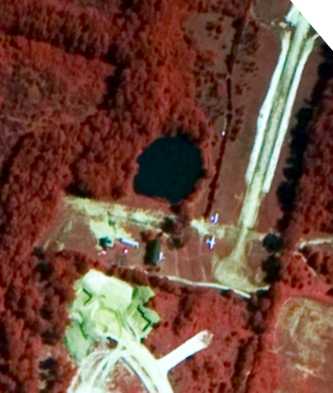
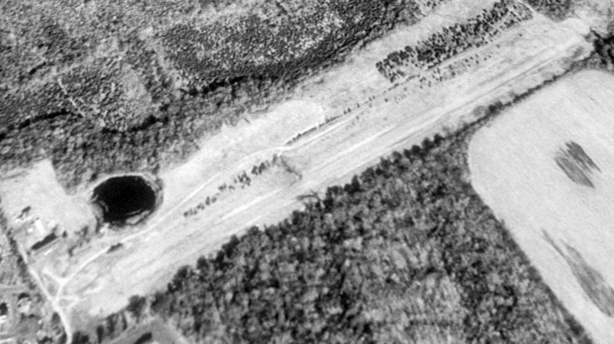
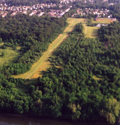
Paul Freeman visited the June Airfield site in 1999, to find the runway still in very good shape,
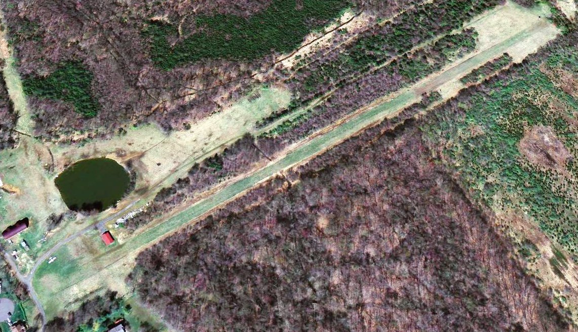
June Airfield is located along the bank of the Potomac River, in a now heavily built suburban area.
The housing development of Countryside abuts the south side of the airfield property,
and the airfield may be seen in between 2 houses at the end of a cul-de-sac.
The airfield consists of a single 2,500' grass runway, approximate alignment 3/21.
A private home sits next to the runway, along with a barn with large doors that apparently served as a hangar.
Aerial view of June Runway 3 taken 5/2000 by Paul Freeman from a Piper Warrior.
USGS aerial photo 2002.
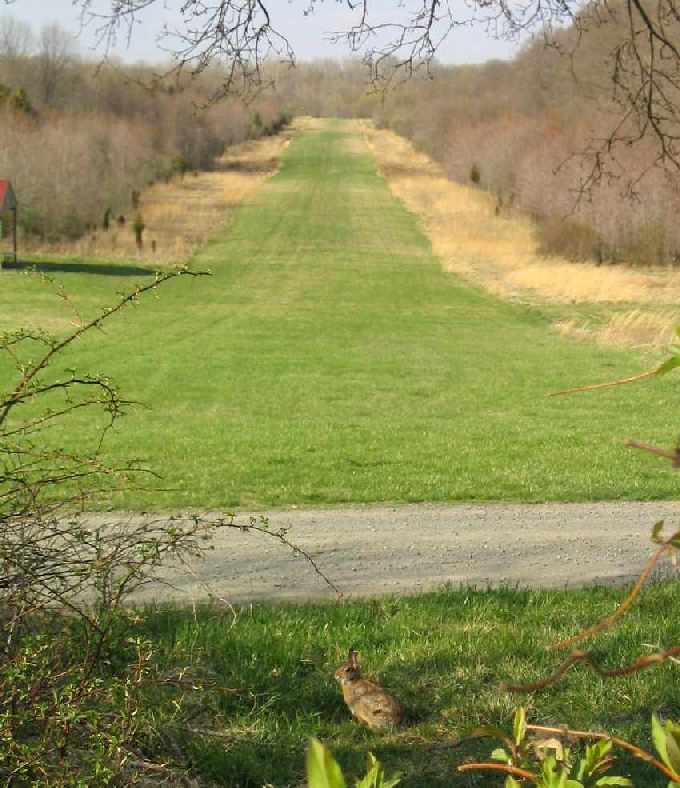
An "airport bunny" surveys the scene at the June Airfield.
Photo by Paul Freeman, 2004, looking north along the runway.
A 2004 photo by Paul Freeman looking north at a 1946 Ercoupe & a 1964 Smith Miniplane at the June Airfield.
As of 2004, these 2 planes were based at June, but were not reguarly flown.
The owner of June Airfield recalled, “In 2004 a [U.S. Government] Blackhawk landed to check out the Ercoupe & the Smith,
I guess they thought they (the airplanes tied up near blue barrels) were a threat of some type.
Since 9/11 not too many pilots are venturing into the ADIZ which is really too bad.”
A 2005 aerial view looking northwest at June Field showed the Ercoupe parked on the southwest end.
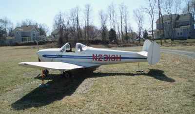
An undated picture looking south at the Ercoupe at June Airfield, from a 2006 advertisement for the plane.
The seller described the plane as “Ercoupe 415-C. Serial # 2943 N-2318H.
Continental C75-6-12, converted to C85 Serial number 3048-6-12.
718 hrs total time since new. All logs since new. Currently registered but has not been in the air since 1968.
Hangared until last year. Of course out of annual. Needs all AD's checked since 1968.
Fabric wings, metal prop, air worthiness certificate. Sport Light Aircraft eligible.
1,260 max take off weight. Electric start. Remember, this aircraft has not been airborne in almost 40 years.
Title search is clean. I registered her in November of 2005.”
The last aerial view which has been located showing an aircraft at June Field was a 2006 aerial view looking northwest, showing the Ercoupe parked on the southwest end.
The owner of June Airfield reported in 2007, “I did taxi the Ercoupe around one day before I sold it & I had quite an audience watching from Selden Court.
In the last 12 months, a Piper Cub dropped in that wanted to land on a grass strip
and a Hughes 500 had to land due to Air Force One being in the vicinity.
The Cub did a full-stop landing & I went down & talked to him for a few minutes.
It surprised me since there is a deer stand on the northwest side of the airstrip at the northern end.
Anyway he made it in & out with no issue.”
The owner of June Airfield reported that as of 2007 he no longer keeps any planes at the field.
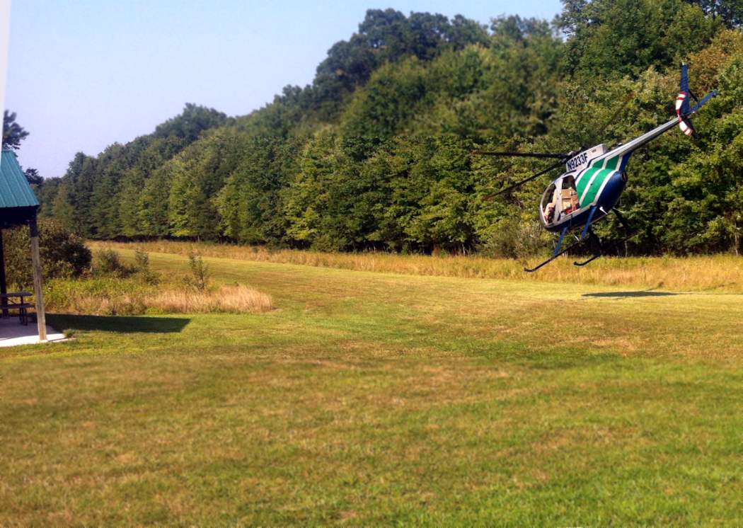
An 8/27/14 picture by Jim Askegren looking northeast at a Hughes 369HS of Bussmann Aviation taking off along June Field's runway after picking up a passenger.
Kevin Bachand reported in 2020, I went to June Field today. There appears to be a gravel road running down the center of the grass runway for its entire length.”
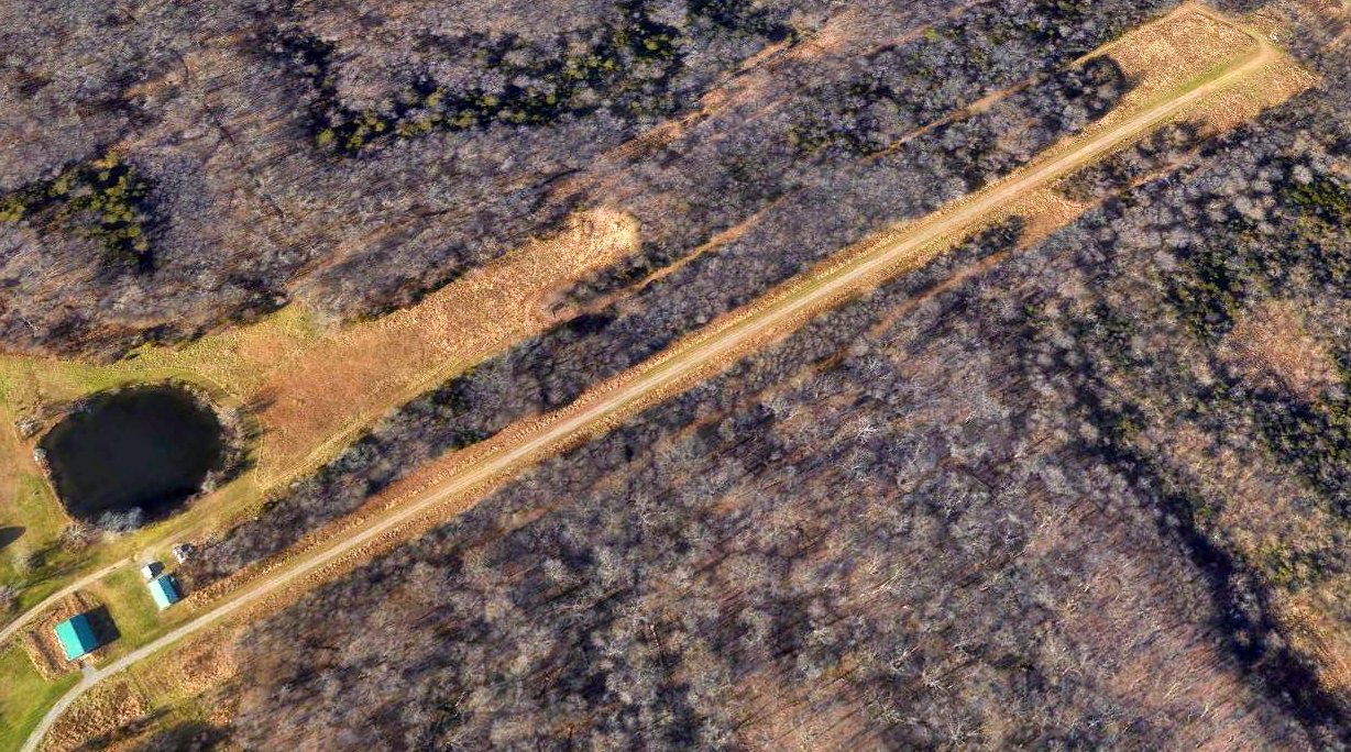
A 2020 aerial view looking northwest showed a gravel road which extends along June Field's former runway.
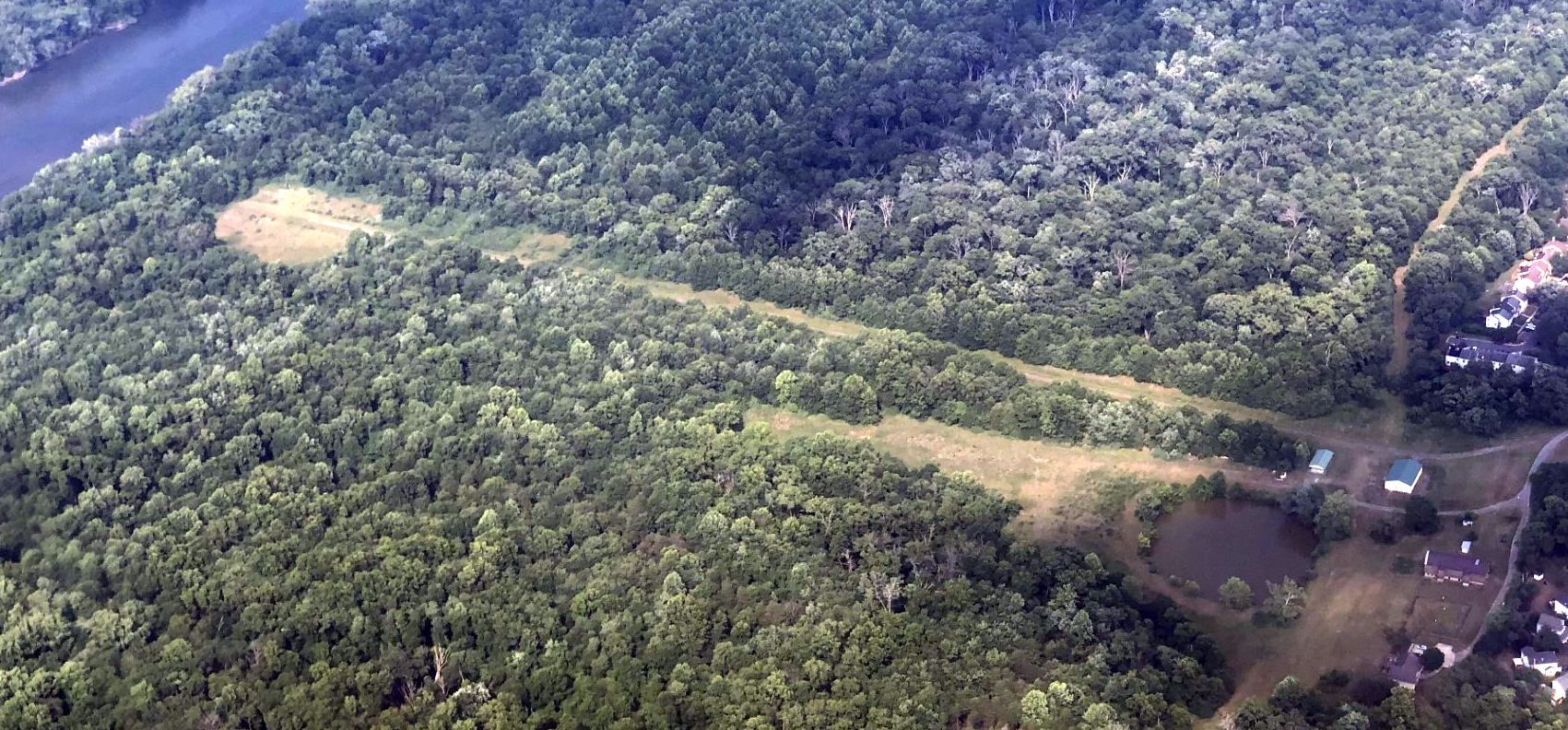
A 6/17/23 aerial view by Paul Freeman looking northeast at the June Field former runway.
In 2024, June Airfield owner Jim Askegren was contacted by the VA Department of Aviation's 2024 Private Airport Survey, and he responded that June Field was no longer in use.
____________________________________________________
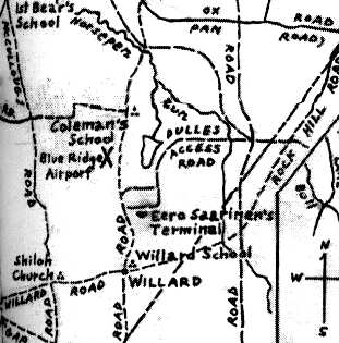
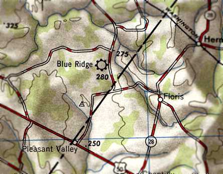
Blue Ridge Airport, Chantilly, VA
38.96, -77.454 (West of Washington, DC)
Blue Ridge Airport, as depicted on the April 1940 Washington Sectional Chart.
Of the millions of travelers who pass through Washington Dulles International Airport each year,
most likely almost none of them are aware that the site was once home to another airport,
established 24 years before the opening of Dulles Airport.
According to the book "Loudoun Discovered" by Eguene Scheel,
Harry Sager leased land for $50 / month from Otho Kirwood to establish an airport.
The field consisted of 2 grass strips, each a half-mile long, in the shape of an "X".
Next to the strips were 2 hangars & the Blue Ridge Flying Club shack.
Blue Ridge Airport was chartered by the U.S. In 1938,
as Loudoun County's first official airport (even though it was predated by Wallace George's field in Leesburg).
Harry Sager wanted to be an airline pilot, and needed to accumulate flying hours.
He initially had 3 aircraft based at Blue Ridge: a Piper J-2 Cub, a J-3, and a Stinson MS8-A.
Buddy Thompson taught flying at Glascock Field,
and performed aerobatics in a WW2 surplus T-19 trainer to attract sightseers for $5/hour.
Blue Ridge Airport was not yet depicted on the January 1940 Washington Sectional Chart.
The earliest depiction of the field which has been located was on the April 1940 Washington Sectional Chart.
However, note that this chart depicted Blue Ridge Airport as an auxiliary airfield in a location somewhat different (south of Route 50) than its eventual location.
Was Blue Ridge Airport originally located south of Route 50, or was this an erroneous depiction?
The September 1940 Washington Sectional Chart continued to depict Blue Ridge Airport south of Route 50.
The location & runway configuration of Blue Ridge Airport (just left of the center),
as depicted on an undated map from the book "Loudoun Discovered".
According to the book, Blue Ridge Airport was located "west of the Sterling Road & a mile north of the Willard Crossroads".
Harry Sager left Blue Ridge for Eastern Airlines in 1941,
and rented out the field to E.C. Germain, the manager of Hybla Valley Airport in Alexandria.
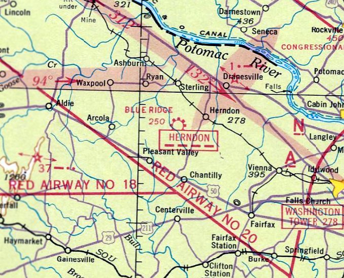
Blue Ridge Airport was depicted in its correct location (north of Route 50) on the November 1941 Washington Sectional Chart.
It had also been upgraded compared to earlier charts by being depicted as a commercial/municipal airport.
Blue Ridge Airport was reportedly closed temporarily in 1942,
due to wartime security decrees that required either a 24-hour guard over all aircraft or the removal of propellers at night.
However it continued to be depicted on 1942-45 Washington Sectional Charts.
The earliest photo which has been located of the Blue Ridge Airport
was an 11/14/43 aerial view looking north from the 1945 AAF Airfield Directory (courtesy of Scott Murdock).
It depicted the field as an open grass area.
Blue Ridge Airport was listed as an active airfield in the 1944 US Army/Navy Directory of Airfields (courtesy of Ken Mercer),
and described as having a 2,400' runway.
Blue Ridge Airport was not depicted at all on the 1944 USGS topo map,
but that may have been due to wartime security concerns.
Blue Ridge Airport apparently reopened as WW2 security precautions were relaxed.
The 1945 AAF Airfield Directory (courtesy of Scott Murdock) described Blue Ridge Airport
as a 77 acre rectangular property within which was a sod all-way landing area, measuring 2,100' north/south by 1,800' east/west.
The field was said to have 2 hangars: 41' x 28' wood & metal, and 40' x 28' concrete block.
The field was said to be privately owned & operated.
Blue Ridge was depicted as a commercial airport on the 1945 Washington Sectional Chart (courtesy of John Voss)
and the 1946 Washington Sectional Chart (courtesy of Mike Keefe).
Blue Ridge Airport, as depicted on the 1946 USGS topo map.
Blue Ridge was still depicted as an active airport on the 1947 & 1949 Washington Sectional Charts (courtesy of Mike Keefe),
and described as having a 3,000' unpaved runway.
The earliest photo which has been located showing aircraft at Blue Ridge Airport was a 1949 aerial view.
It depicted the field as having 2 grass runways in an “X”-shape,
with a few small buildings along the road along the east side of the field.
A closeup from the 1949 aerial view, showing 5 planes at Blue Ridge Airport.
Blue Ridge Airport was described in the January 1950 Washington Sectional Chart Aerodromes table as “Usable for emergency”.
The January 1951 Washington Sectional Chart Aerodromes table described Blue Ridge Airport as "Closed".
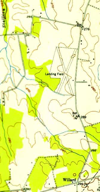
Blue Ridge Airport was labeled simply as “Landing Field on the 1951 USGS topo map,
which may have indicated that it was closed by that point.
It was depicted as having 2 unpaved runways in an X-shape, with one small building to the east of the runway intersection.
The 1951 Washington Local Aeronautical Chart depicted Blue Ridge Airport as having a 3,300' unpaved runway.
Blue Ridge Airport was still depicted on the July 1951 Washington Sectional Chart,
but the remarks in the Aerodromes table on the reverse side of the chart said "Closed".
The field was described as having 2 runways, with the longest being a 3,300' unpaved strip.
Blue Ridge Airport was no longer depicted on the January 1952 Washington Sectional Chart.
The last photo which has been located showing aircraft at Blue Ridge Airport was a 3/12/52 aerial view.
It depicted the field as having 2 grass runways in an “X”-shape,
with a few small buildings along the road along the east side of the field,
and one single-engine aircraft on the southeast side of the field.
A 1953 aerial view depicted the runways & buildings of Blue Ridge Airport (from the Fairfax County Historical Imagery Viewer),
but it was not apparent if the airport was still in operation by that point.
The runways were no longer depicted on the 1955 USGS topo map, although the small cluster of airports buildings still was depicted.
The property was labeled instead as “Dulles International Airport”.
The 2 grass runways of Blue Ridge Airport were still clear on a 1957 aerial view (from the Loudoun County GIS system, courtesy of Jim Askegren),
but the buildings had been removed from the east side of the field, and there were no aircraft visible on the property.
With the increase in Washington area airline traffic, the federal government eventually determined a need for a new international airport for the area,
and Chantilly was chosen as the site.
A total of 9,800 acres were purchased or condemned by the federal government from 1959-61,
including the site of the former Blue Ridge Airport.
Harry Sager proposed naming the new field Blue Ridge Airport, but Dulles Airport was chosen as the name instead.
A 1962 aerial photo showed that the construction of Dulles Airport
had completely eradicated any trace of the former Blue Ridge Airport.
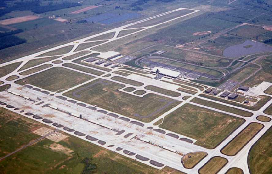
A June 1966 aerial view by Chris Kennedy looking northwest at the site of the former Blue Ridge Airport,
which by then had been covered with the new Dulles Airport.
Interesting, note that only a single airliner was visible anywhere on the massive Dulles ramps,
even though the airport had been open for 4 years by that point.
A far cry from the airport's present level of activity.
Today, the site of the former Blue Ridge Airport is located roughly on the site of the Dulles Air Freight complex,
northwest of the intersection of Autopilot Drive & Aviation Drive,
just northwest of the passenger terminal.
____________________________________________________
Lipscomb Airfield, Leesburg, VA
39.155, -77.553 (Northwest of Washington, DC)
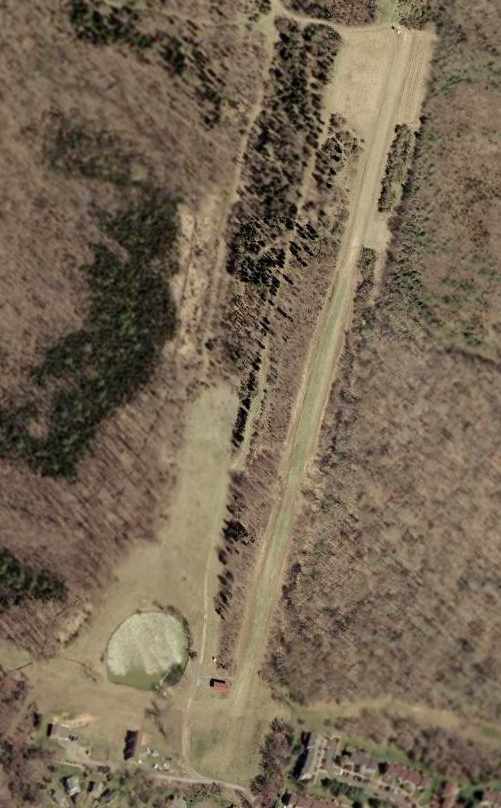
A 1958 aerial view depicted the Lipscomb airfield as having a single grass runway,
with a taxiway leading to several buildings on the north side of the field.
The private airfield of Ross Lipscomb (an early Loudoun County pilot) was located just north of the town of Leesburg.
Lipscomb was known for performing aerobatics at the nearby Wallace George Airfield in Leesburg.
According to Merton Meade, “It was strictly a private-use field on his own farm which, at one time, was as much as 1,500 acres.
He often brought one of his DC-3 ships in & out.
Ross owned East Coast Flying Service which was a charter & non-scheduled operation
which was based at Washington National & at Martinsburg.”
The date of construction of Lipscomb Airfield is unknown.
No airfield at all was depicted at this location on aeronautical charts from 1939/46/49/51/63/64/70,
nor on USGS topo maps from 1946/52/63/69.
As a private airfield, it could have been omitted from aeronautical charts at the owner's request.
The earliest depiction that has been located of the Lipscomb Airfield was a 1958 aerial view.
It depicted the field as having a single grass runway,
with a taxiway leading to several buildings on the north side of the field.
A 1964 aerial view depicted the Lipscomb airfield in an unchanged manner.
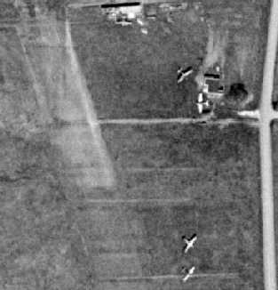
A closeup from the 1970 aerial view depicted 2 light aircraft at the Lipscomb Airfield.
The single northwest/southeast runway of the Lipscomb Airfield was labeled simply as “Landing Strip” on the 1970 USGS topo map.
A 1974 aerial view depicted a single aircraft on the field.
The single runway of the Lipscomb Airfield was labeled simply as “Landing Strip” on the 1981 USGS topo map.
The single 3,800' northwest/southeast runway of the Lipscomb Airfield was labeled simply as “Landing Strip” on the 1984 USGS topo map.
Merton Meade recalled, “My wife & I lived on the Lipscomb farm for about 7 years,
and I taught Ross Lipscomb's son Sam to fly there.
I kept my 2 Taylorcrafts there at the time, and they're both in the aerial photo [the 1988 photo below].
When I endorsed Sam's logbook as being 'ready to solo except for his age'
(he was about 14 or so at the time & I'd taught him to fly in my Taylorcraft... Ross insisted he learn in a conventional gear ship),
Ross then bought Sam a brand new 172! This was in 1984.
Sam soloed for the first time (the first LEGAL solo, that is) on his 16th birthday in February of 1986,
at the farm, and we had a wonderful party that night at the next door farm, Selma Plantation.
Wonderful memories.”
Tony Beck recalled, “We kept the family Aeronca Chief & Taylorcraft on Ross Lipscomb's field at Raspberry Plain.
When I was instructing in the G-109 motor glider out of Leesburg, that was where we did 'off field' landings.”
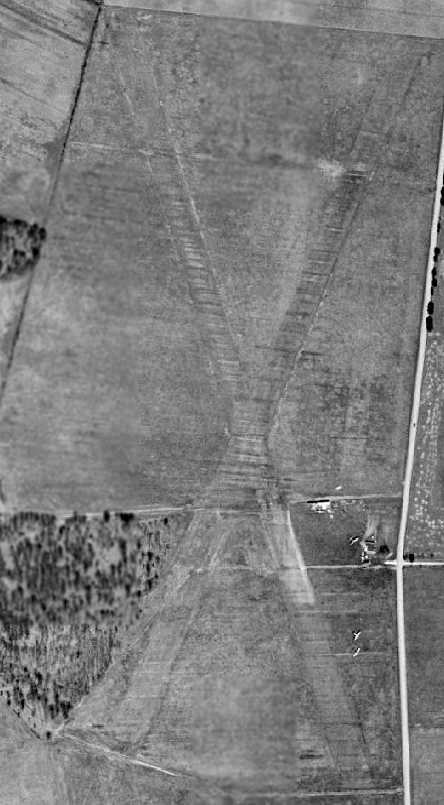
A 4/10/88 USGS aerial view looking south at the Lipscomb Airfield showed it to consist of a single 3,800' northwest/southeast runway.
Note the plane on the runway, southeast of the intersecting taxiway, and the 4 planes parked east of the buildings in the foreground of the picture.
The date of closure of the Lipscomb Airfield has not been determined.
Merton Meade recalled that Ross sold the Lipscomb Farm around 1995, at which point the airfield presumably was closed.
A 1995 aerial photo showed the eastern half of Lipscomb Airfield had had been covered by the Raspberry Falls housing development & golf course,
but the western half of the runway remained recognizable.
A 2003 aerial photo showed houses covering the length of the former Lipscomb Airfield runway.
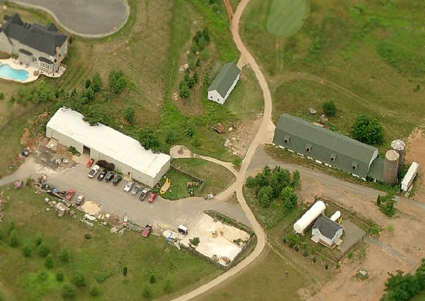
A circa 2001-2005 aerial view looking west at the buildings which remain from the former Lipscomb Airfield,
which are presumably used for maintenance of the present-day golf course which occupies the site.
A 2016 aerial view of the site of Lipscomb Airfield shows that some of the former airfield buildings remain intact on the north side of the property (foreground of photo),
but the former runway has been covered by houses.
Lipscomb Airfield was located on the west side of Route 15, one mile north of the intersection of Business Route 15 & the Route 15 Bypass.
See also: Washington Post, Loudoun News, 11/18/01.
____________________________________________________
Since this site was first put on the web in 1999, its popularity has grown tremendously.
If the total quantity of material on this site is to continue to grow,
it will require ever-increasing funding to pay its expenses.
Therefore, I request financial contributions from site visitors,
to help defray the increasing costs of the site
and ensure that it continues to be available & to grow.
What would you pay for a good aviation magazine, or a good aviation book?
Please consider a donation of an equivalent amount, at the least.
This site is not supported by commercial advertising –
it is purely supported by donations.
If you enjoy the site, and would like to make a financial contribution,
you
may use a credit card via
![]() :
:
Please consider checking the box to make a monthly donatation.
For a mailing address to send a check, please contact me at: paulandterryfreeman@gmail.com
If you enjoy this web site, please support it with a financial contribution.
please contact me at: paulandterryfreeman@gmail.com
If you enjoy this web site, please support it with a financial contribution.
____________________________________________________
This site covers airfields in all 50 states.