Abandoned & Little-Known Airfields:
Eastern Virginia
© 2002, © 2023 by Paul Freeman. Revised 8/5/23.
Click here for the site's main menu. This site covers airfields in all 50 states:
___________________________________________________
Please consider a financial contribution to support the continued growth & operation of this site.
A. P. Hill AAF #2 / Port Royal AAF (revised 6/12/20) - Bland's Wharf Intermediate Field (added 9/15/19) - Burgess Airfield (revised 8/5/17) - Harbor View Airport (revised 8/5/23)
Moss Neck AAF #3 / Pender AHP (revised 2/9/20) - Milford Intermediate Field (added 9/15/19) - Nottingham Field (revised 3/17/18) - Reno Skypark (revised 12/16/22)
Shannon Field (original location) (revised 4/27/18) - Tappahannock Flight Strip / Tapphannock Municipal (revised 6/20/19)
____________________________________________________
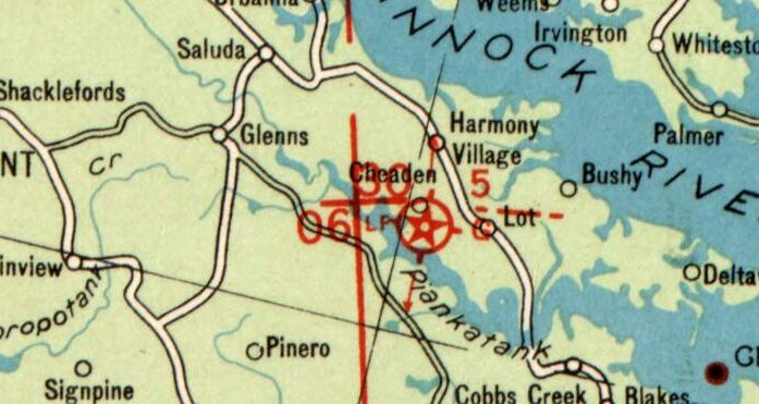
Bland's Wharf Intermediate Field, Freeport, VA
37.55, -76.487 (Southeast of Washington, DC)
Bland's Wharf Intermediate Field, as depicted on the March 1932 AAC Strip Map #4 (courtesy of John McDonald).
Photo of the airfield while in use has not been located.
Bland's Wharf Intermediate Field was not yet depicted on the 1929 AAC Strip Map #4 (according to John McDonald).
It was evidently established at some point between 1929-31, as one of the Civil Aeronautics Administration's network of Intermediate Fields,
which were built along commercial airways between major cities, intended for emergency use by airliners.
Bland's Wharf Intermediate Field was located on the Norfolk-Washington airway.
The earliest reference which has been located to Bland's Wharf Intermediate Field was in the 1931 & 1932 Commerce Department Airway Bulletins (according to John McDonald).
The described Bland's Wharf as the Commerce Department Intermediate Field Site 5 on the Norfolk-Washington Airway.
It was said to be a 50 acre L-shaped sod field with 2 runways, measuring 2,250' north/south & 1,990' east/west.
It had a directional arrow, beacon, boundary, approach, and obstruction lights, but no servicing facilities.
The earliest depiction which has been located of Bland's Wharf Intermediate Field was on the March 1932 AAC Strip Map #4 (courtesy of John McDonald).
It depicted Bland's Wharf as Site 5.
Bland's Wharf Intermediate Field evidently did not last long, as it was no longer listed in the 1933 Commerce Department Airway Bulletin (according to John McDonald).
This may have been due to the Norfolk-Washington Airway seemingly having been rerouted along the Atlanta-New York Airway,
possibly because it cut right between the Dahlgren Proving Ground restricted areas.
Bland's Wharf Intermediate Field was not depicted on the March 1935 Norfolk Sectional Chart or the 1942 USGS topo map.
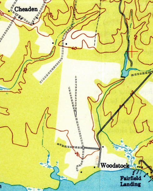
Bland's Wharf Intermediate Field was not labeled on the 1949 USGS topo map,
but it did depict an L-shaped clearing at the location which correlates with the airfield's previous description.
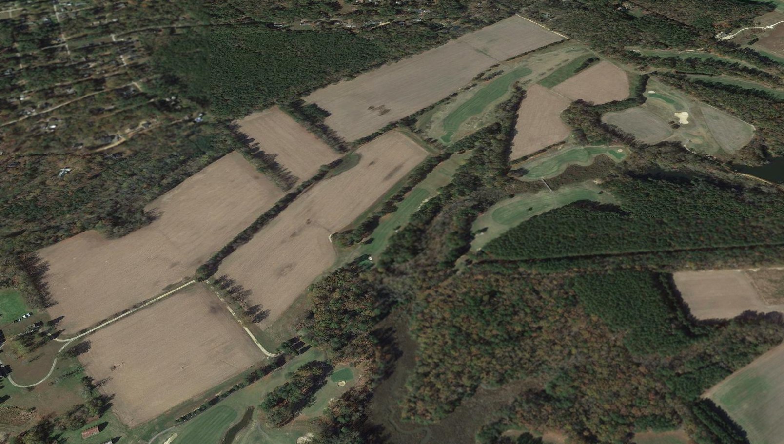
A 2015 aerial view looking northwest at the site of Bland's Wharf Intermediate Field showed the L-shaped clearing of the possible runway alignment remained recognizable on the northwest corner of the site.
The Piankatank River Golf Course had been constructed along the eastern portion of the possible airfield location.
Thanks to John McDonald for pointing out this airfield.
____________________________________________________
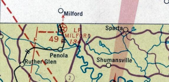
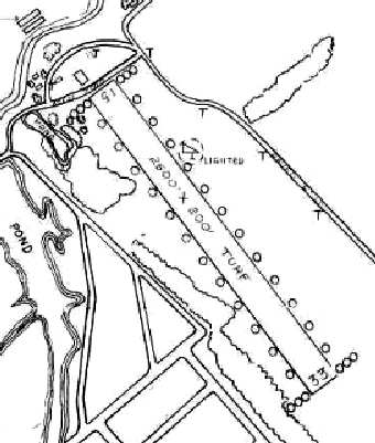
Milford Intermediate Field, Milford, VA
38.007, -77.368 (South of Washington, DC)
Milford Intermediate Field, as depicted on the 1929 AAC Strip Map #4 (courtesy of John McDonald).
Photo of the airfield while in use has not been located.
The date of construction of this early airport has not been determined.
Milford was established in the 1920s as one of the Civil Aeronautics Administration's network of Intermediate Fields,
which were built along commercial airways between major cities, intended for emergency use by airliners.
Milford Intermediate Field was located on the Atlanta - New York airway,
and also had Airway Beacon 50A on the property (later redesignated Beacon 49A).
The earliest reference which has been located of Milford Intermediate Field was in the 1928 Aircraft Year Book (according to John McDonald),
which described Milford as a lighted Intermediate Field.
The earliest depiction which has been located of Milford Intermediate Field was on the 1929 AAC Strip Map #4 (courtesy of John McDonald).
The 1931 & 1932 Commerce Department Airway Bulletins (according to John McDonald) described Milford as the Commerce Department Intermediate Field Site 50A on the Atlanta - New York Airway.
It was said to be a 55 acre L-shaped sod field with 2 runways measuring 2,100' & 2,000'.
It had a directional arrow, beacon, boundary, approach, and obstruction lights, but no servicing facilities.
The 1933 & 1934 Commerce Department Airway Bulletins (according to John McDonald) described Milford as the Commerce Department Intermediate Field Site 49 on the Atlanta - New York Airway.
It was said to be an L-shaped sod field with 2 runways measuring 2,100' north/south & 2,000' northeast/southwest.
It had beacon, boundary, approach, and obstruction lights, but no servicing facilities.
The earliest Sectional Chart depiction which has been located of Milford Intermediate Field was on the March 1935 Norfolk Sectional Chart (courtesy of John McDonald).
The 1938 Commerce Department Airway Bulletin (according to John McDonald) described Milford in an unchanged fashion.
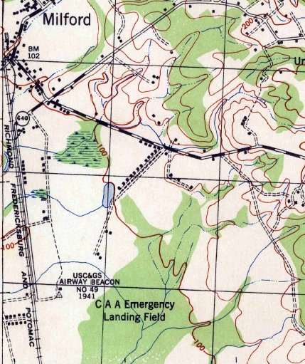
The earliest topo map depiction which has been located of Milford Intermediate Field was on the 1942 USGS topo map (courtesy of John McDonald).
It labeled the “CAA Emergency Landing Field” & the “USC&GS Airway Beacon #49”, but did not depict any runways or property outline.
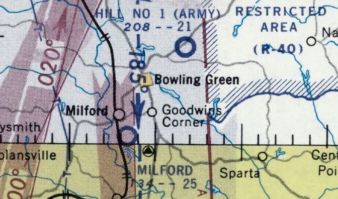
The last aeronautical chart depiction which has been located of Milford Intermediate Field was on the July 1957 Norfolk Sectional Chart (courtesy of John McDonald).
It depicted Milford as having a 2,500' unpaved runway.
Milford Intermediate Field was evidently abandoned at some point between 1957-59,
as it was no longer depicted on the January 1959 Norfolk Sectional Chart.
The 1961 USGS topo map no longer depicted Milford Intermediate Field, but still depicted the “Beacon” along the west side of the former airfield.
The earliest photo which has been located of the site of Milford Intermediate Field was a 1966 aerial view.
It depicted the western portion of the site as a grass field, with trees on the eastern half.
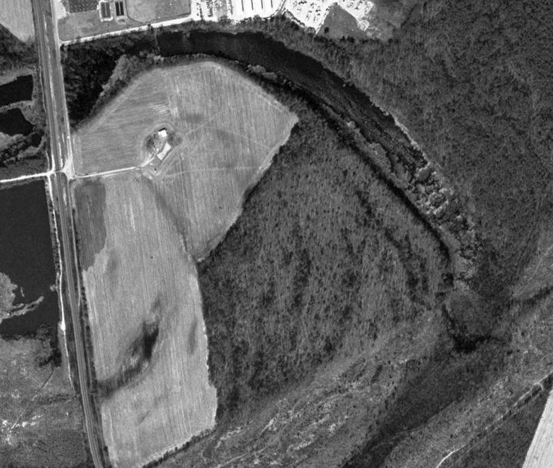
The earliest photo which is available of the site of Milford Intermediate Field was a 1994 aerial view (courtesy of John McDonald).
John McDonald observed that the former Airway Beacon power shed might still have remained, at the northeast corner of the site.
A 2019 aerial view showed the property outline of Milford Intermediate Field remained recognizable,
but the possible former Airway Beacon power shed had been removed at some point between 1994-2019.
Thanks to John McDonald for pointing out this airfield.
____________________________________________________
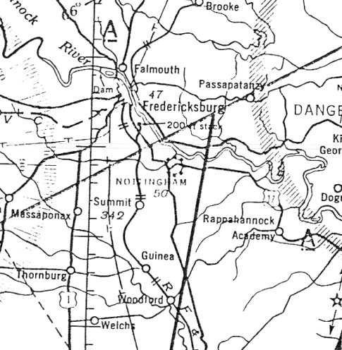
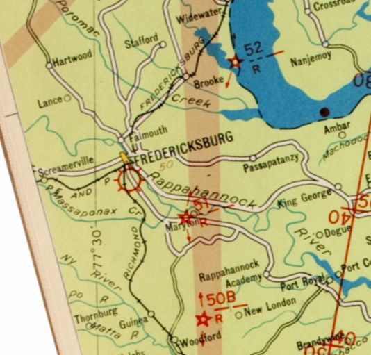
Nottingham Field, Lee Hill, VA
38.243, -77.395 (South of Washington, DC)
Nottingham Field, as depicted on the April 1940 Washington Sectional Chart.
The date of construction of this small early airport has not been determined.
The 1930 Air Navigation Map did not depict Nottingham Field, but did depict Commerce Department Airway Beacon #51 about a mile to the east,
along the Washington-Richmond Airway.
The Airway Beacon was depicted in the same fashion on the 1935 Washington Sectional Chart.
According to the book "Virginia Airports" by Vera Rollo & Norman Crabill (published by the VAHS),
“Nottingham Field (near Fredericksburg VA) [was] open in the late 1930s with Richard Holladay, operator.”
Nottingham Field was not yet depicted on the January 1940 Washington Sectional Chart.
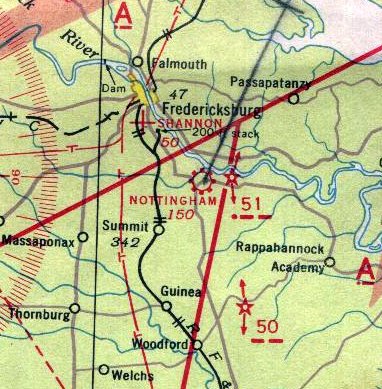
The earliest depiction which has been located of Nottingham Field was on the April 1940 Washington Sectional Chart.
It depicted Nottingham as a commercial/municipal airport.
Wayde Minami reported, “I am the MD ANG historian. From August 4-21, 1941, our 104th Observation Squadron
was temporarily located at Nottingham Field VA supporting exercises going on at the A.P. Hill Military Reservation.
The 104th was originally from Logan Field (east of Baltimore).”
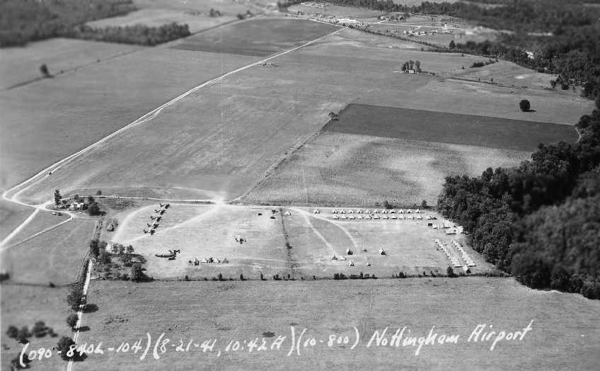
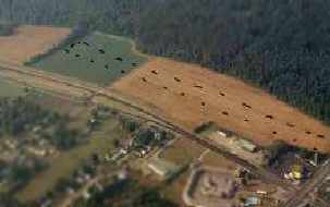
An 8/21/41 aerial photo by Frank Matricciani of the “Nottingham Airport” (courtesy of Carmel Matricciani).
It showed a large open grass field, on the side of which were a tent encampment, along with 7 single-engine aircraft.
According to Wayde Minami, “The aircraft look like they might be O-46s, which the squadron flew at the time (along with O-47s).”
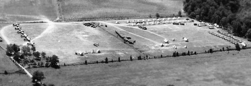
An 8/21/41 aerial photo by Frank Matricciani of 7 unidentified aircraft & an encampment at the “Nottingham Airport” (courtesy of Carmel Matricciani).
The last aeronautical chart depiction which has been located of Nottingham Field was on the November 1941 Washington Sectional Chart (courtesy of Ron Plante).
It depicted Nottingham as a commercial/municipal airport.
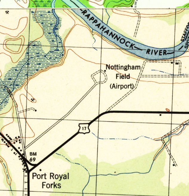
The most detailed depiction which has been located of Nottingham Field was on the 1942 USGS topo map (courtesy of Steve Bennett).
It depicted “Nottingham Field (Airport)” along the southwest shore of the Rappahannock River, having a single small building along a circular driveway, but it did not depict any other airfield features.
Nottingham Field was evidently closed at some point between 1941-42, as it was no longer depicted on the May 1942 Washington Sectional Chart (courtesy of Ron Plante).
Its closure was presumably due to the wartime restrictions on small civilian airports near the coasts.
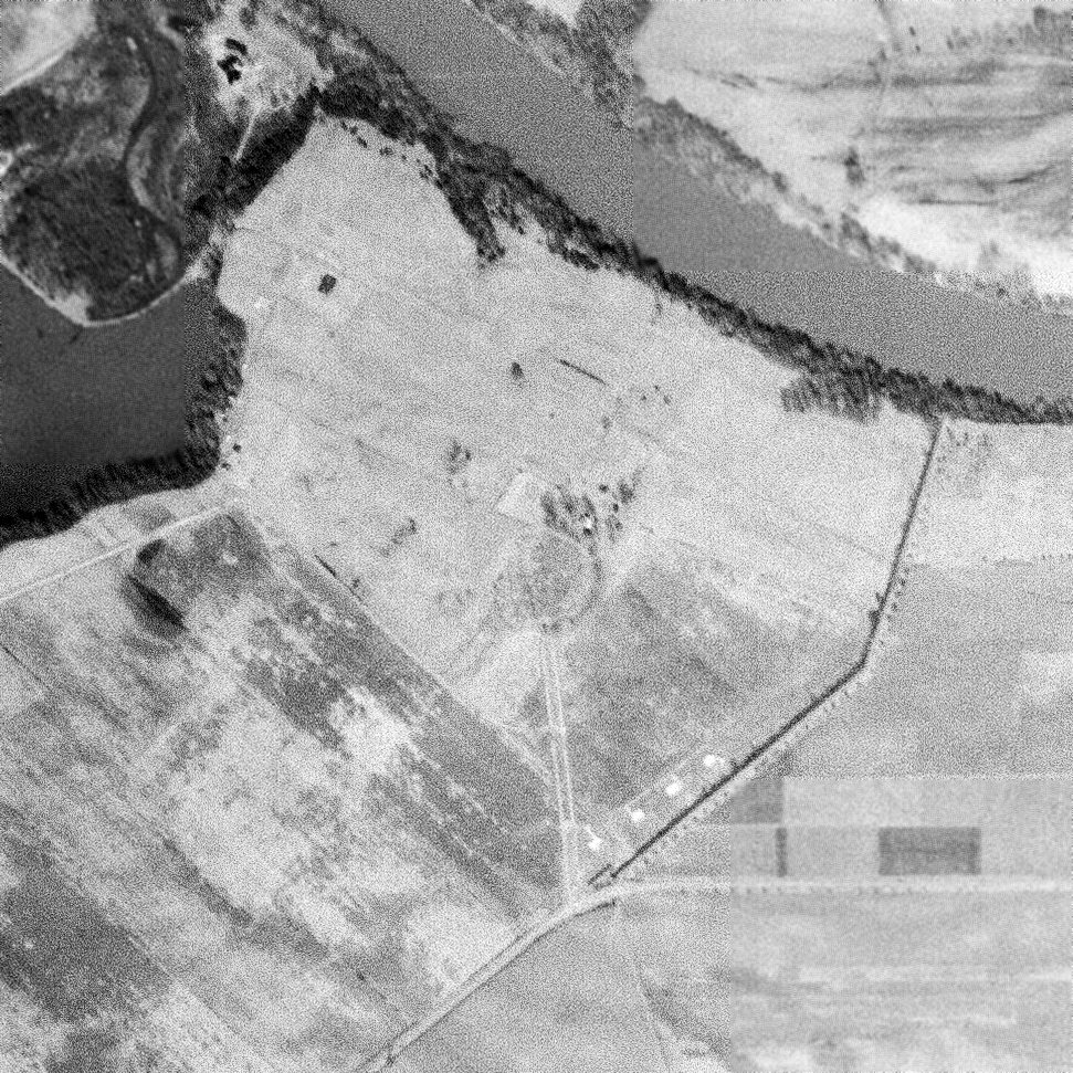
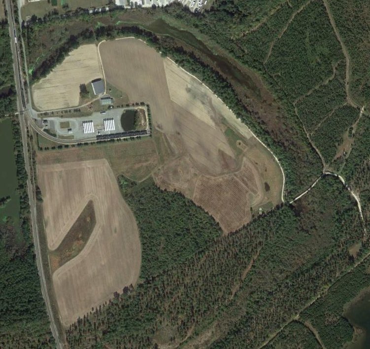
A 1960 USGS aerial view of the site of Nottingham Field depicted the site as remaining unredeveloped,
with a single small building along a circular driveway, and an open grass field.
But it did not depict any signs of recent aviation use.
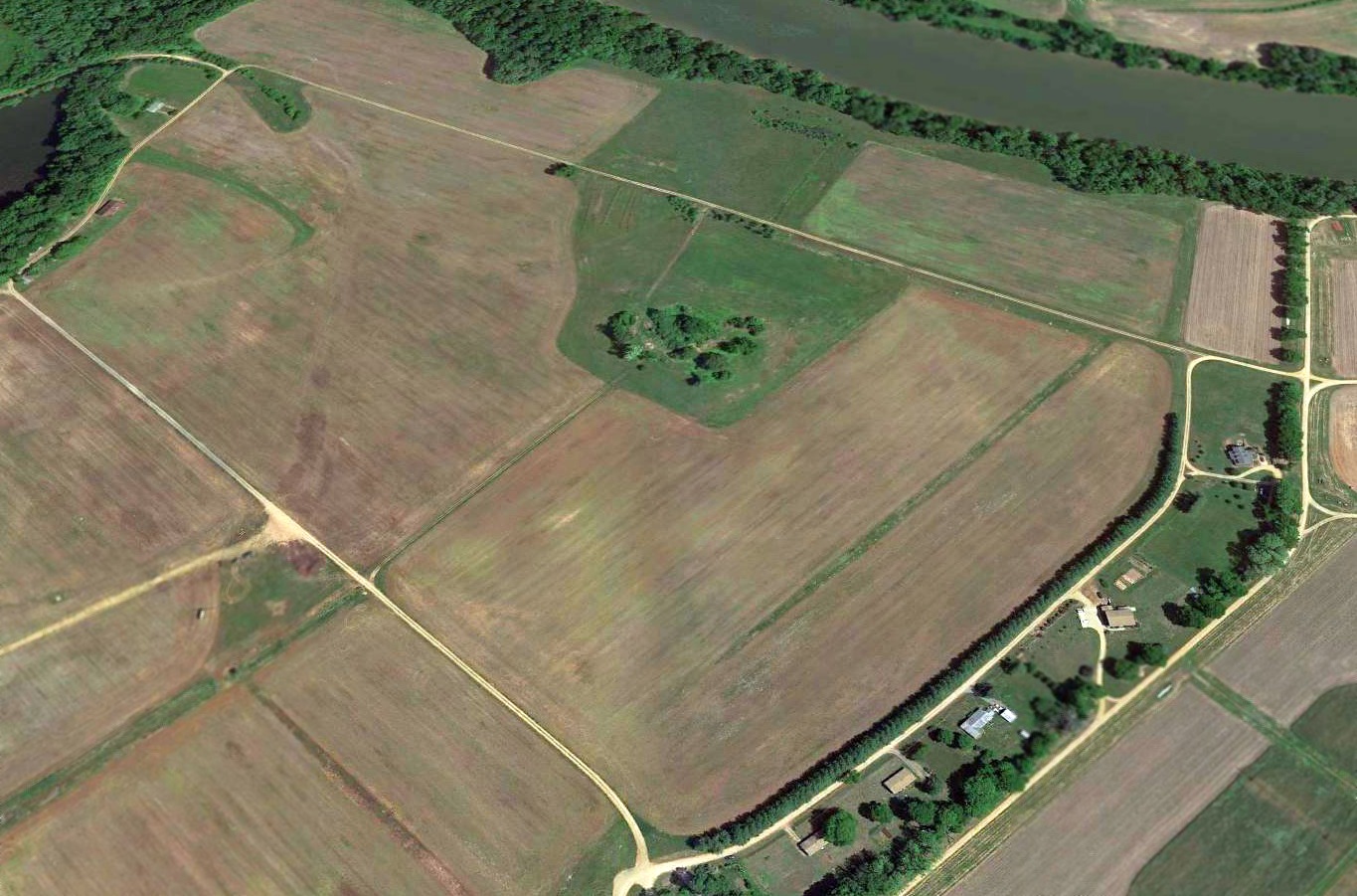
A 2015 aerial view showed the circular driveway feature remained recognizable at the center of the site of Nottingham Field, but the site was otherwise unrecognizable as a former airfield.
The site of Nottingham Field is located northwest of Nottingham Drive, appropriately enough.
Thanks to Steve Bennett for pointing out this airfield.
____________________________________________________
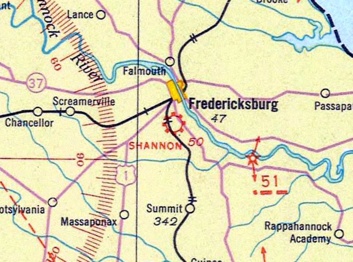
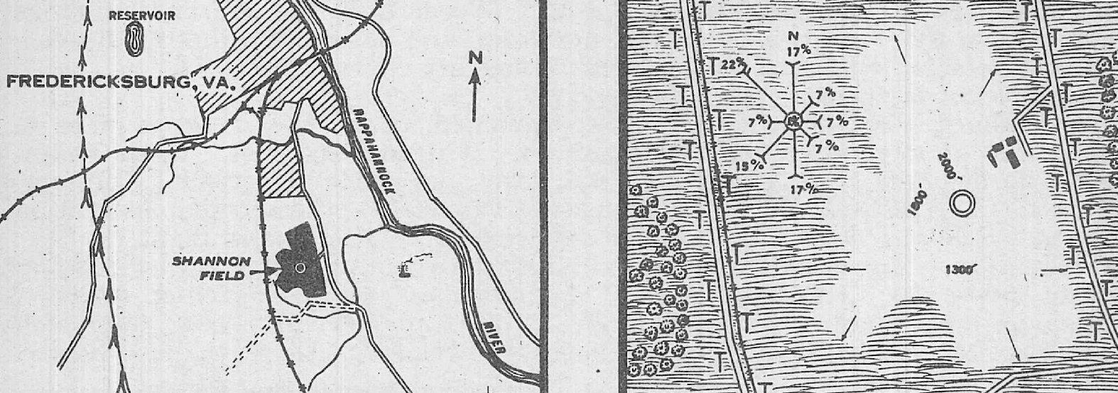
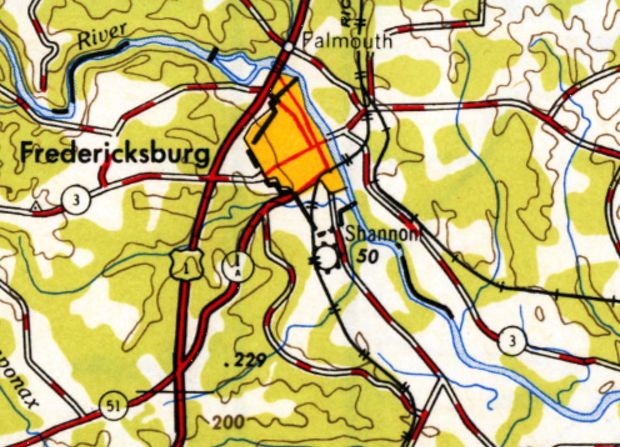
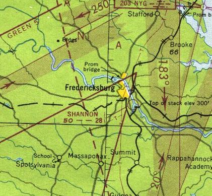
Shannon Field (original location), Fredericksburg, VA
38.277, -77.456 (South of Washington, DC)

The original location of Shannon Field, as depicted on the 7/10/29 Commerce Department Airway Bulletin.
Photo of of the airport while in use has not been located.
The original location for this small general aviation airport was located a half-mile northwest of its eventual location.
According to the current Shannon Field website, Sidney Shannon learned to fly in 1927 at Hoover Field, across the river from Washington DC.
He opened the first Shannon Field in the 1920s.
According to the book "Virginia Airports" by Vera Rollo & Norman Crabill (published by the VAHS),
“Sidney L. Shannon Sr. opened a turf airstrip, Shannon Airport,
with a single building, on the family farm in Fredericksburg.”
The earliest depiction which has been located of Shannon Field was a 7/10/29 Commerce Department Airway Bulletin.
It described Shannon Field as a 60 acre irregularly-shaped sod field measuring 1,850' north/south.
Three hangars were depicted on the east side, and the owner & operator were listed as S.L. Shannon.
The earliest aeronautical chart depiction which has been located of Shannon Field was on a 1930 Air Navigation Map.
The 1935 Washington Sectional Chart depiction Shannon Field as a commercial/municipal airport.
The 1935 Air Pilot's Register (courtesy of Paul McMillan) described Shannon Field as a municipal airport having 3 sod runways, with the longest being 2,000' north/south.
Three small buildings were depicted on the east side.
The 1943 USGS topo map depicted the original Shannon Field as an irregularly-shaped property outline, labeled simply “Landing Field”,
with 2 small buildings on the east side.
The original location of Shannon Field as depicted on the 1948 USGS topo map.
The last aeronautical chart which depicted the original location of Shannon Field was the 1949 Washington Sectional Chart.
It depicted Shannon Field as having a 2,800' unpaved runway.
The original location of Shannon Field was evidently replaced at some point between 1949-51,
as the 1951 Washington Sectional Chart depicted Shannon as having been relocated to its eventual location, a half-mile further southeast.
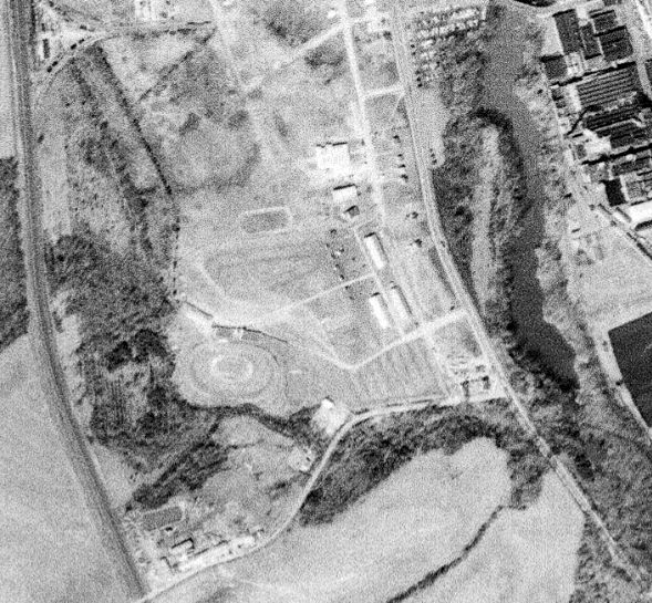
A 3/1/60 USGS aerial view showed the county fairgrounds occupying the site of the original Shannon Field,
with possibly a runway outline still recognizable along the north side of the property.
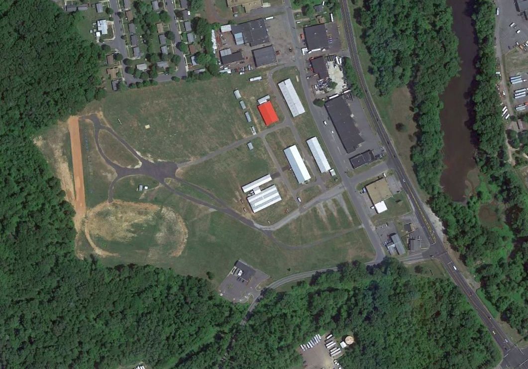
A 2015 aerial view showed no trace remaining of the original Shannon Field.
The site of the original Shannon Field is located west of the intersection of Oldfield Street & Airport Avenue, appropriately enough.
____________________________________________________
Burgess Airfield, Dahlgren, VA
38.35, -77.07 (Northeast of Richmond, VA)
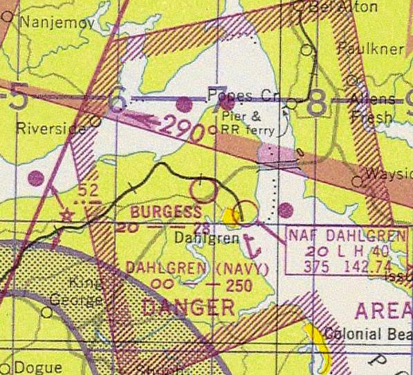
The earliest depiction which has been located of Burgess Airfield was on the 1947 Washington Sectional Chart.
This private airfield was located directly across Route 301 from the Navy's Dahlgren airfield.
According to Clifton Huston, “I believe it was named for a local King George County resident 'Blue' Burgess.”
According to Sean Gates, “I talked with Peggy Mullen, the daughter of Blue Burgess.
Peggy tells me that Burgess Field, the one that became Bayberry Estates, actually was the 2nd location.
The original Burgess Field was a short distance away on Route 614 (also known as 'B-Gate Road'),
and had to be moved when the Navy base took the land it stood on, which is why they bought the Cloverdale/Bayberry land.”
Sean continued, “Roland Burgess & his wife Viola purchased that land from the Peed family in August of 1941.
Prior to Peed ownership, it was part of the Cloverdale Estate.
It must have taken a few years for the Burgesses to establish it as an airfield.”
Burgess Airfield was not yet depicted on the 1946 USGS topo map nor on the October 1946 Washington Sectional Chart (courtesy of Ron Plante).
The earliest depiction which has been located of Burgess Airfield was on the 1947 Washington Sectional Chart,
which depicted Burgess as having a 2,800' unpaved runway.
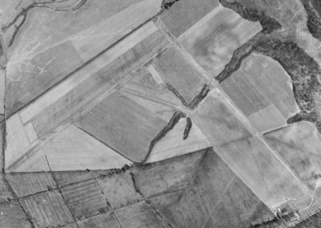
The only photo which has been located showing Burgess Airfield in operation was a 3/27/52 aerial view.
It depicted Burgess as having 2 grass runways, with 4 single-engine aircraft & a few small buildings at the south end of the field.
According to Sean Gates, “At least one of those 2 little buildings near the road was a gas station that the Burgesses owned.”
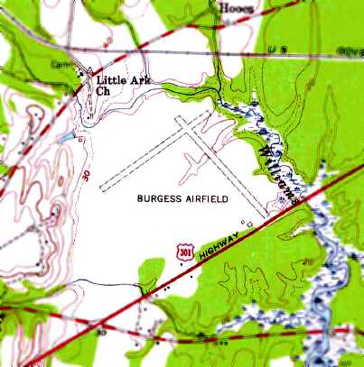
The most detailed depiction which has been located of Burgess Airfield was on the 1955 USGS topo map (courtesy of Clifton Huston).
It depicted Burgess as having 2 perpendicular unpaved runways, on the northwest side of Route 301.
Two small buildings were depicted on the south side of the field, but it is not known if these buildings were airfield-related.
According to the book "Virginia Airports" by Vera Rollo & Norman Crabill (published by the VAHS),
“Burgess Airport was a personal field with 3 turf strips, unattended.”
According to Sean Gates, “In August 1956, Mr. Burgess passed away, and left the land to his widow & their grown children.
In 1958 they sold it to a developer from Maryland.”
The last depiction which has been located of Burgess Airfield was on the July 1960 Washington Sectional Chart.
It depicted Burgess as a private field having a 2,600' unpaved runway.
According to Sean Gates, “In October 1961 Viola Burgess passed away.
By this time the land was already under development for what was then known as the Cloverdale Subdivision.
However due to legal difficulties (the developers seem to have been rather shady) the subdivision didn't really start coming together until 1964.”
Burgess Airfield was no longer depicted on the 1964 Washington Sectional Chart.
According to Sean Gates, “The Cloverdale Subdivision opened in 1967.”
A 1967 aerial view showed that houses had been built covering the southeastern Burgess Airfield runway,
but the majority of the northeast/southwest runway remained clear.
The 1968 USGS topo map (courtesy of Clifton Huston) no longer depicted the Burgess Airfield runways,
but instead showed that the southeastern end of the former southeast/northwest runway had become a street (Danube Drive) lined with homes.
According to Sean Gates, “At least one of those 2 little buildings near the road was a gas station that the Burgesses owned.
At some later date it was replaced with a modern cinderblock building, which still stands [as of 2017], but the original structure would likely have been a wooden one.
The other building is probably a building my friends & I explored once in the 1980s, when it still stood behind the current gas station building.
It was a garage, kind of like a small barn, green with a tin gambrel roof, and there was an old Dodge Brothers sedan from the 1920s inside of it, and what looked like spare airplane parts.
That building, however, is long gone. It collapsed in the early 1990s & was burned. The car was rescued and, I hope, restored.”
The 1983 USGS topo map (courtesy of Clifton Huston) showed that the northeast/southwest Burgess Airfield runway
had also become a street (Delaware Drive) lined with homes.
A 2002 aerial view showed the alignment of the former Burgess Airfield runways was recognizable by the residential streets built over it.
The site of Burgess Airfield is located northwest of the intersection of Route 301 & Danube Drive.
Thanks to Clifton Huston for pointing out this airfield.
____________________________________________________
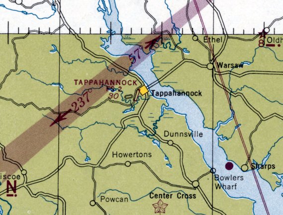
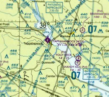
Tappahannock Flight Strip / (Original) Tappahannock Municipal Airport (W79), Tappahannock, VA
37.925, -76.872 (Northeast of Richmond, VA)
The Tappahannock Flight Strip, as depicted on the September 1944 Norfolk Sectional Chart.
This airfield was originally built during WW2 as one of numerous Flight Strips constructed across the country,
which were intended to be used as emergency airfield by military aircraft.
The Tappahannock Flight Strip was evidently built at some point between 1943-44,
as it was not yet depicted on the March 1943 Norfolk Sectional Chart nor the 1944 USGS topo map.
The earliest reference which has been located to Tappahanncok Flight Strip
was in the 4/1/44 US Army/Navy Directory of Airfields (courtesy of Ken Mercer).
It described the "Tappahannock Flight Strip, Army" as having a 4,000' hard-surfaced runway, with a total landing distance of 8,000' available.
The earliest depiction which has been located of the Tappahanncok Flight Strip was on the September 1944 Norfolk Sectional Chart.
It depicted "Tappahannock FS" as having a paved northeast/southwest runway.
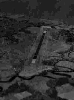
The earliest photo which has been located of the Tappahannock Flight Strip was a circa 1943-45 aerial view looking north
from the 1945 AAF Airfield Directory (courtesy of Scott Murdock) depicted the field as having a single asphalt runway.
The 1945 AAF Airfield Directory (courtesy of Scott Murdock) described Tappahannock Flight Strip as “Inactive”.
The field was said to consist of a single 4,000' asphalt NNE/SSW runway, and to not have any hangars.
The field was described as being owned & operated by the VA State Highway Department.
At some point between 1945-53, the Tapphannock Flight Strip was reused as a civil airport.
The July 1953 Chesapeake Bay USAF World Aeronautical Chart (courtesy of Chris Kennedy)
depicted "Tappahannock FS" as having a 5,000' hard-surface runway.
The 1961 USGS topo map depicted a single paved 6,100' northeast/southwest runway, labeled simply as “Landing strip”.
By the time of the 1965 Norfolk Sectional Chart (courtesy of John Voss),
Tappahannock's usable runway length had been reduced significantly, to only a 3,000' bituminous strip,
as a displaced threshold had been applied to the southern end.
A 1/13/67 USGS aerial photo showed only a single light aircraft visible on Tappahannock Airport.
A factory had been built adjacent to the southeast side of the runway at some point between 1945-67.
The 1968 Virginia Airport Directory (courtesy of Don Thompson)
depicted Tappahannock Municipal Airport as having a single 2,800' paved Runway2/20,
with a 50' width having been newly paved, over an original 150' width of “old pavement grass growing through cracks”.
An “administration trailer” was depicted across the street to the west, but there were no hangars depicted.
The operator was listed as the Town of Tappahannock, with the manager listed as G.C. Clanton.
The “Industrial Building” was depicted adjacent to the southeast side of the airport (a denim factory), as well as the water tower.
Several improvements were made at Tappahannock during the 1960s,
when Priority Air Dispatch ran an air courier service there,
according to a historical account displayed in 2008 in the new Tappahannock Essex County Airport.
Improvements included a hangar & terminal building.
The 1971 USGS topo map depicted a single paved 3,200' northeast/southwest runway, labeled simply as “Landing strip”,
with a road crossing the southern portion of the runway, and a factory having been built adjacent to the southeast end.
Priority Air Dispatch had ended their operations at Tappahannock by the 1970s
(according to a historical account displayed in 2008 in the new Tappahannock Essex County Airport), and the airport went into a period of decline.
The 1980 USGS topo map labeled the site as Tappahannock Municipal Airport.
The 1982 AOPA Airport Directory (courtesy of Ed Drury) listed the field's operator as Essex Aviation Inc.
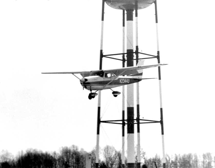
An undated view of a Cessna passing nearby to the water tower at Tappahannock,
from the International Flying Farmers Magazine (courtesy of Kenneth Keeton).
The picture was captioned, “What looks like a close encounter of the 3rd Kind is really Hank & Mabel Osterhout landing at Tappahannock
for the Virginia Flying Farmers March meeting.”
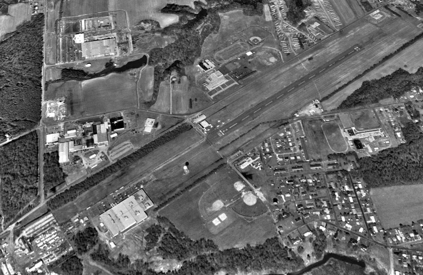
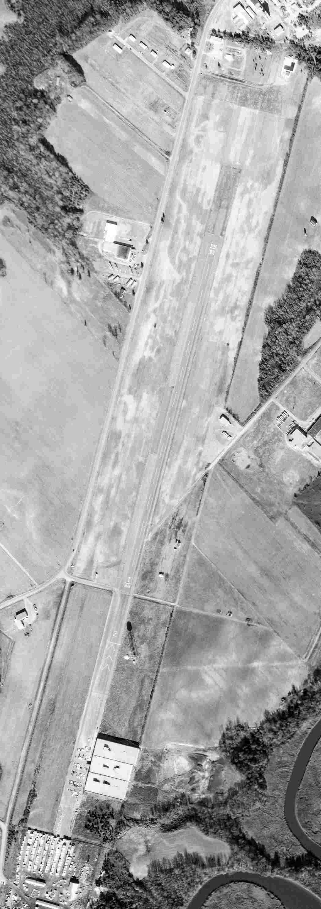
A 1994 USGS aerial view looking northwest at the original Tappahannock Municipal Airport showed a total of 8 light aircraft parked on the ramp on the west side of the field.
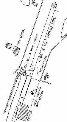
The 1998 VA Airport Directory depicted Tappahannock as having a single 2,785' asphalt Runway 2/20,
with an administration building & main hangar on the west side (which had evidently been added at some point between 1969-98).
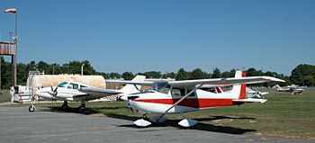
A circa 1990s photo showing several Cessnas at Tappahannock.
A circa 1990s aerial view looking north at Tappahannock.
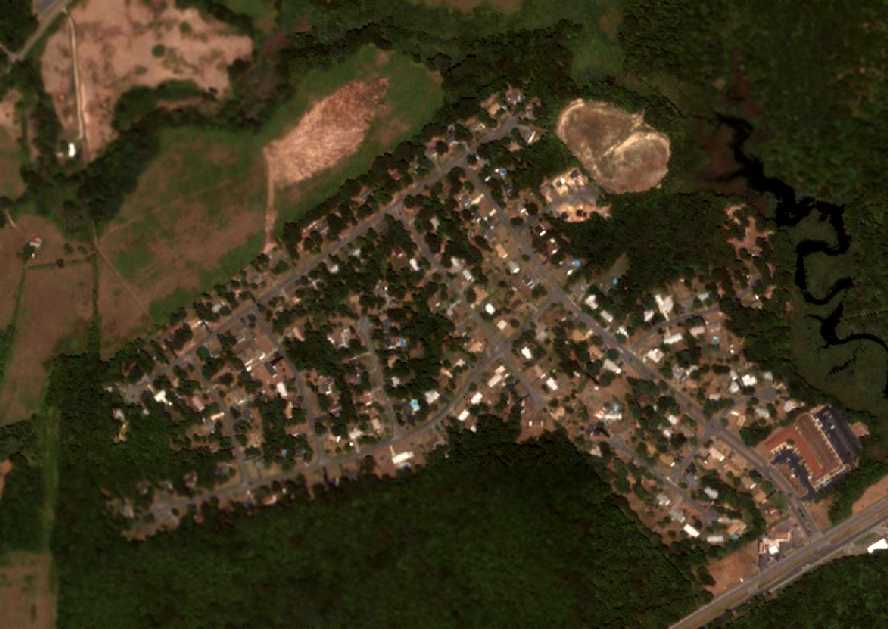
Paul Freeman flew a Diamond Katana DA-20 into Tappahannock in 1999.
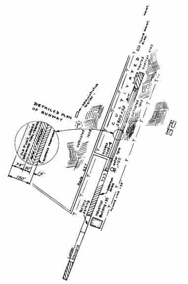
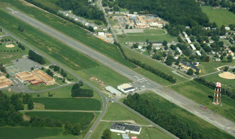
The airfield had a very unusual configuration: a large factory sat directly adjacent to the southeast side of the runway.
Most of the lower section of the original runway had been fenced off & was used as a parking lot for the factory.
As a result, the threshold of Runway 2 had been significantly displaced, reducing the length of the maintained runway to only 2,785'.
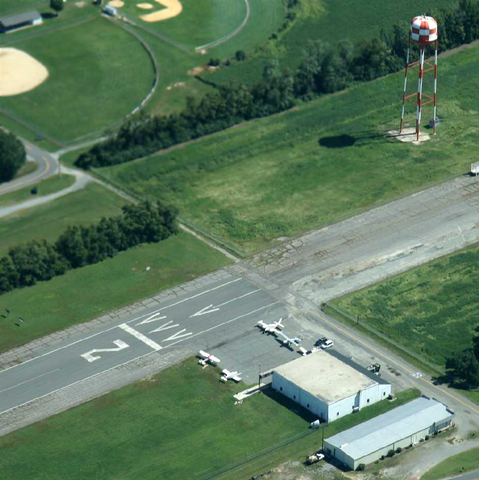
Plus, a tall water tower sat very close to the runway, just north of the factory.
These obstacles combined to make an approach on Runway 2 very uncomfortable (even with the significantly displaced threshold).
Tappahannock was still in use (as of 2002) as a general aviation airport,
but the county government had plans to eventually replace Tappahannock
with a newly constructed Tappahannock Essex Airport at Paul's Crossroads (3 miles to the southwest).
When the new airport was opened the original airport would be closed, and the property would be redeveloped as an industrial park.
The Essex County Government web site said that "Essex county began the land acquisition at Paul's Crossroads for the new airport in 1999."
A 5/13/05 photo of a hangar at Tappahannock Municipal Airport.
The factory adjacent to the southeast side of the runway was occupied by H. Warshow & Sons, which manufactured fabric & drapery,
until it closed in 2005, according to an article in the 1/5/07 issue of the Richmond Times-Dispatch.
A July 2006 aerial view by Alex McMahon looking west at the old Tappahannock Airport.
As of 2007 the FAA Airport/Facility Directory listing for the original Tappahannock Municipal Airport
described the field as being owned by the Town of Tappahanncok, with the manager listed as Linwood Wadsworth.
Tappahannock was said to have 16 single-engine aircraft based on the field,
and it was said to host a total of 581 takeoffs or landings per month.
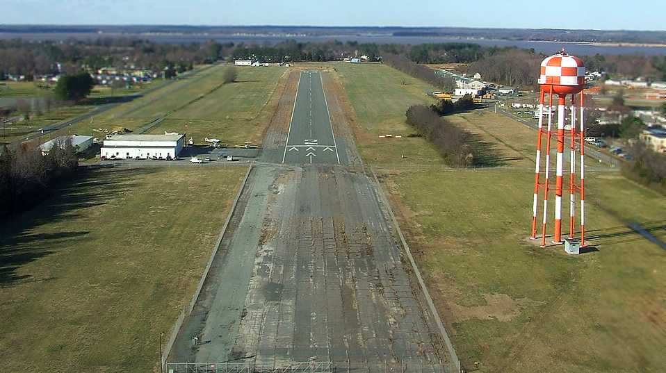
A 3/18/07 aerial view by Peter Palafoutas, taken on final approach for Runway 2.
Three single-engine aircraft were visible near the hangar on the west ramp.
The last aeronautical chart depiction which has been located of the original Tappahannock Airport
was on the August 2007 Washington Sectional Chart.
It depicted Tappahannock as having a single 2,800' paved runway.
According to Orville Ingram, the local newspaper reported that the new Tappahannock-Essex Airport opened on August 18, 2007,
with a 4,300' paved runway with clear approaches (a considerable improvement over the old airport).
The last photo which has been located showing based aircraft at the original Tappahannock Airport was a 9/15/07 aerial view by Seth Cassaday looking northeast.
According to Seth, “The old airport stayed open for some time but only to pilots that were based there.”
A 9/15/07 aerial view by Seth Cassaday looking east at the planes on the Tappahannock Airport ramp.
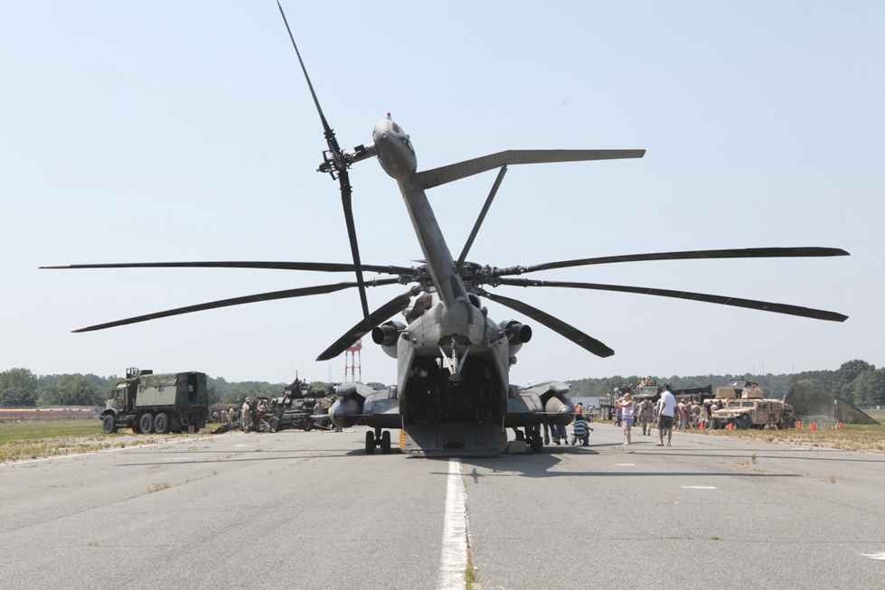
The old Tappahannock Municipal Airport evidently got a large visitor a few years after the airport closed,
as 6/12/10 USMC photo by Tammy Hineline showed a CH-53E Super Stallion helicopter on the Tappahannock runway
during a community outreach day held by the 26th Marine Expeditionary Unit to thank the local community
for their patriotic support & hospitality during Realistic Urban Training at nearby Fort A.P. Hill.
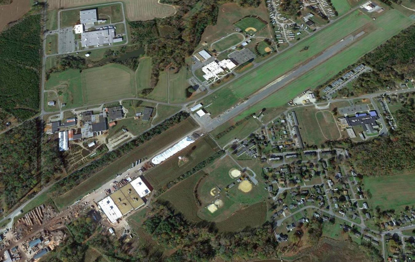
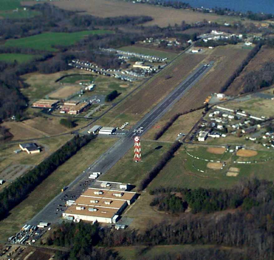
A 2015 aerial view looking northwest shows the original Tappahannock Municipal Airport to remain intact.
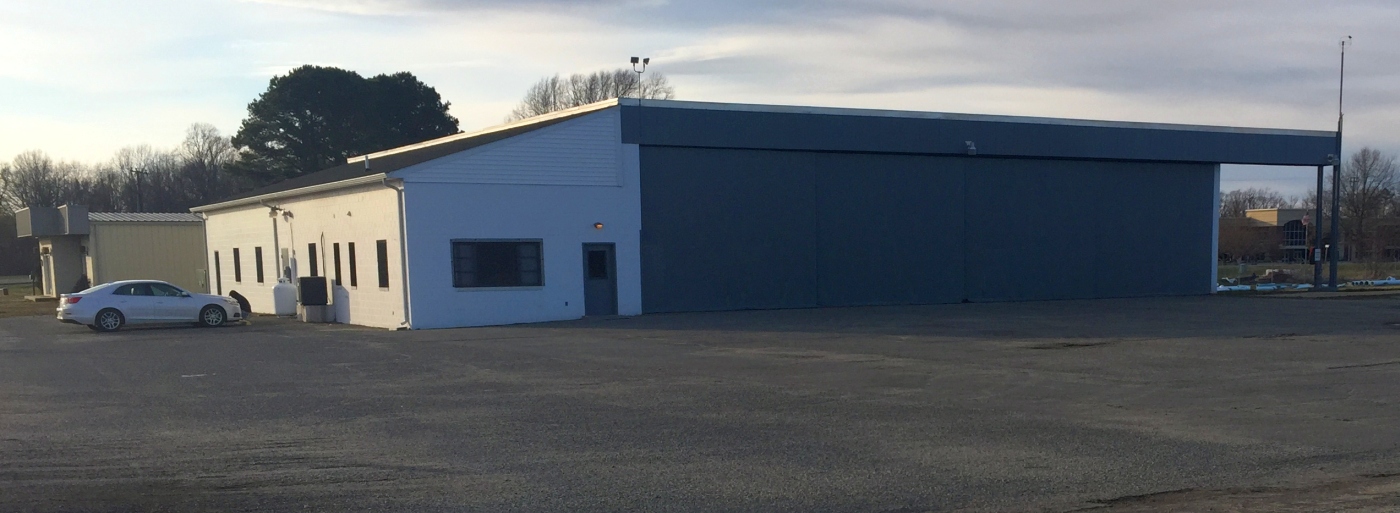
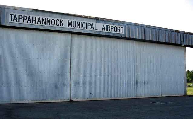
A 3/15/17 photo by Paul Freeman looking northwest at the hangar at the original Tappahannock Municipal Airport.
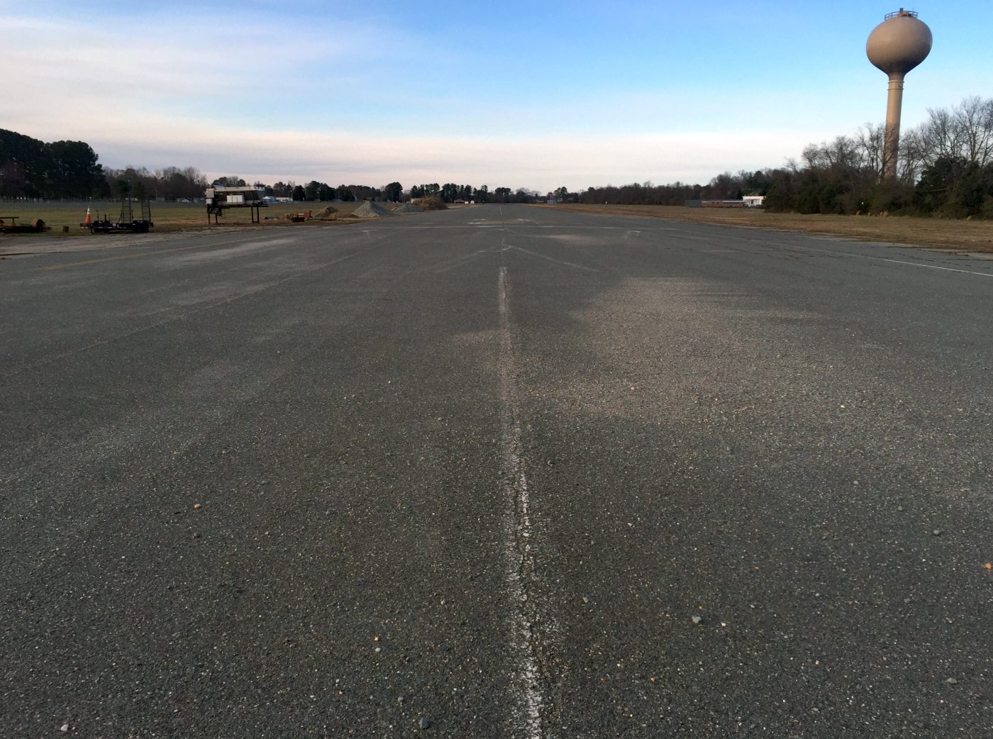
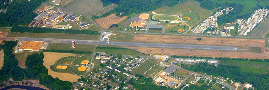
A 3/15/17 photo by Paul Freeman looking northeast along the former runway at the original Tappahannock Municipal Airport.
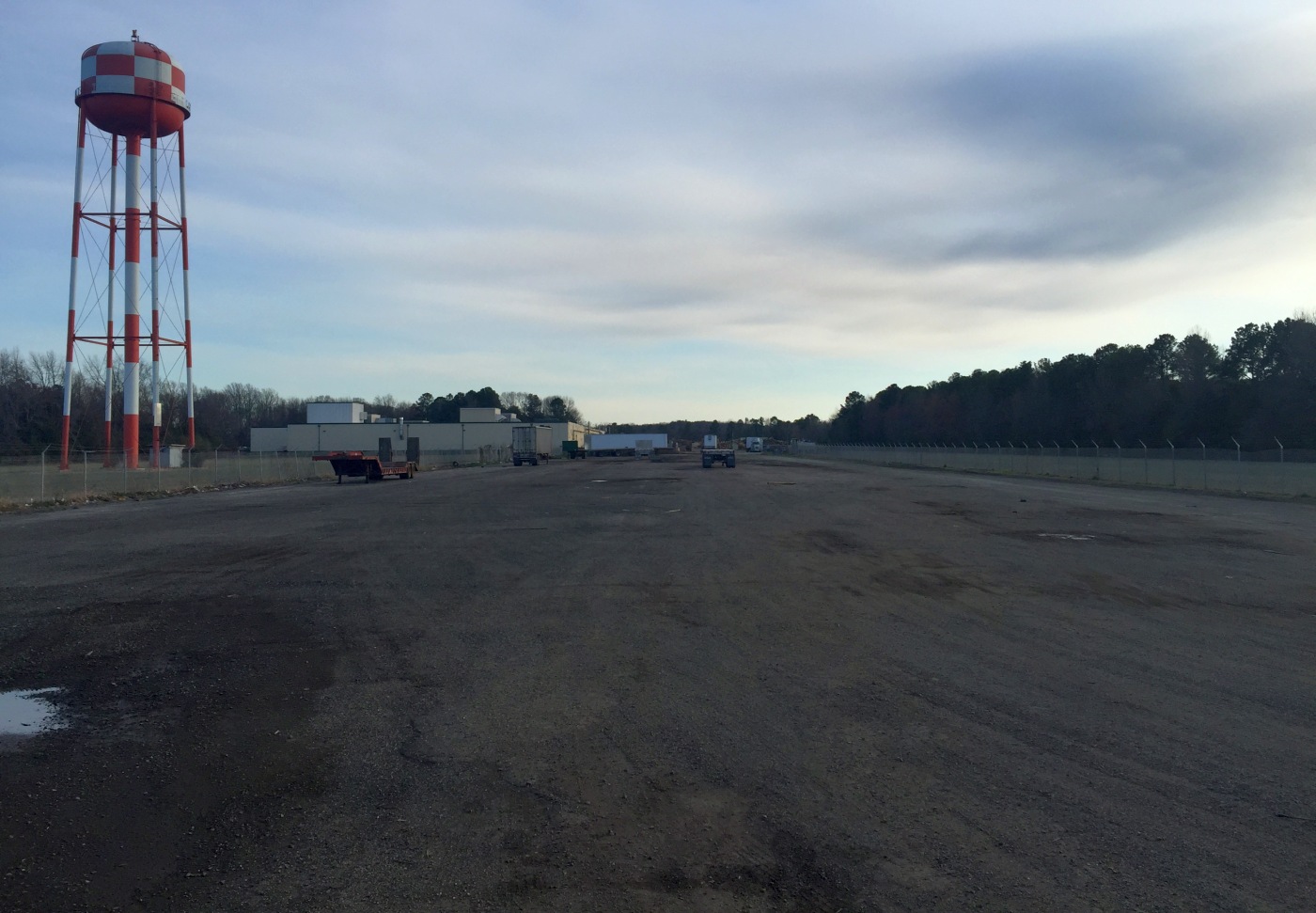
A 3/15/17 photo by Paul Freeman looking southeast along the former runway at the original Tappahannock Municipal Airport.
The original Tappahannock Municipal Airport is located south of the intersection of Route 17 & Airport Road.
____________________________________________________
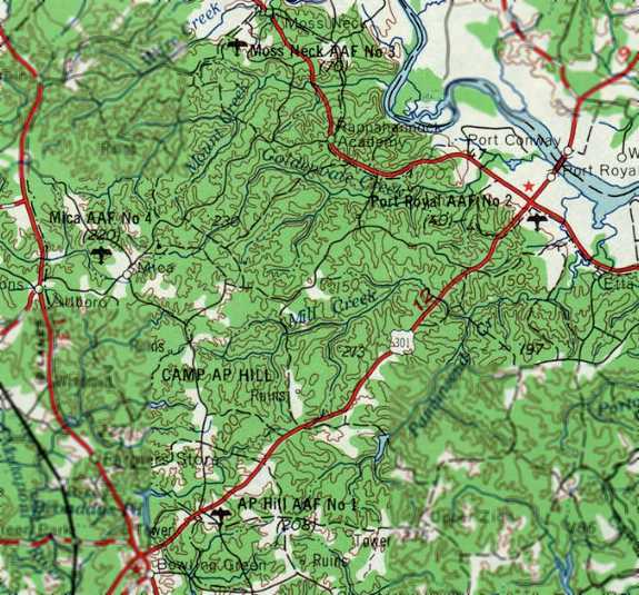
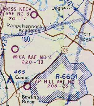
A. P. Hill Army Airfield #2 / Port Royal AAF, Port Royal, VA
38.16, -77.195 (South of Washington, DC)
"Hill #2 (Army)" Airfield, as depicted on the October 1948 Washington Sectional Chart (courtesy of Chris Kennedy).
Photo of the airfield while in use has not been located.
The 76,000-acre Fort A. P. Hill was established as an Army training facility on 6/11/41.
During World War II, the Fort operated as a training site for corps & division-sized units.
The second of what would eventually total 4 airfields within the bounds of the Fort
was evidently established at some point between 1947-48,
as no airfield at this location was depicted on the 1942 USGS topo map
nor the April 1947 Washington Sectional Chart (according to Chris Kennedy).
The earliest depiction of this airfield which has been located
was on the October 1948 Washington Sectional Chart (courtesy of Chris Kennedy).
It depicted "Hill #2 (Army)" Airfield as having a 2,100' unpaved runway.
The 1952 USGS topo map depicted “Hill Airstrip #2” as having a single southeast/northwest runway,
bisected by an unpaved road.
"Hill #2 (Army)" Airfield was depicted on the January 1954 Washington Sectional Chart (courtesy of Chris Kennedy)
as having a 2,100' unpaved runway.
"Hill #2 (Army)" Airfield was depicted on the July 1960 Washington Sectional Chart as having a 2,100' unpaved runway.
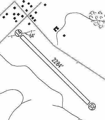
The field had evidently been renamed " Port Royal AAF (#2)" at some point between 1954-60,
as that is how it was listed in the 1960 Jeppesen Airway Manual (courtesy of Chris Kennedy).
The field was depicted as consisting of a single 2,284' unpaved Runway 14/32.
A cluster of small buildings was depicted just north of the airfield,
but none of the buildings appeared to be directly related to the airfield, which was described as being unattended.
Port Royal AAF was still depicted as an active airfield on the February 1962 Washington Sectional Chart (according to Chris Kennedy).
Port Royal AAF #2 (and the other 3 Camp AP Hill Army Airfields), as depicted on the 1963 USGS topo map.
The 1964 USGS topo map depicted “Hill Airstrip #2” as having a single southeast/northwest runway, bisected by an unpaved road.
Port Royal AAF was evidently closed (for reasons unknown) at some point between 1962-64,
as it was no longer depicted at all on the October 1964 Washington Sectional Chart (courtesy of Chris Kennedy),
or subsequent aeronautical charts.
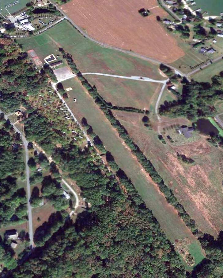
A 1967 aerial view depicted the Port Royal AAF site as an open grass field.
The 1971 USGS topo map no longer depicted Port Royal AAF.
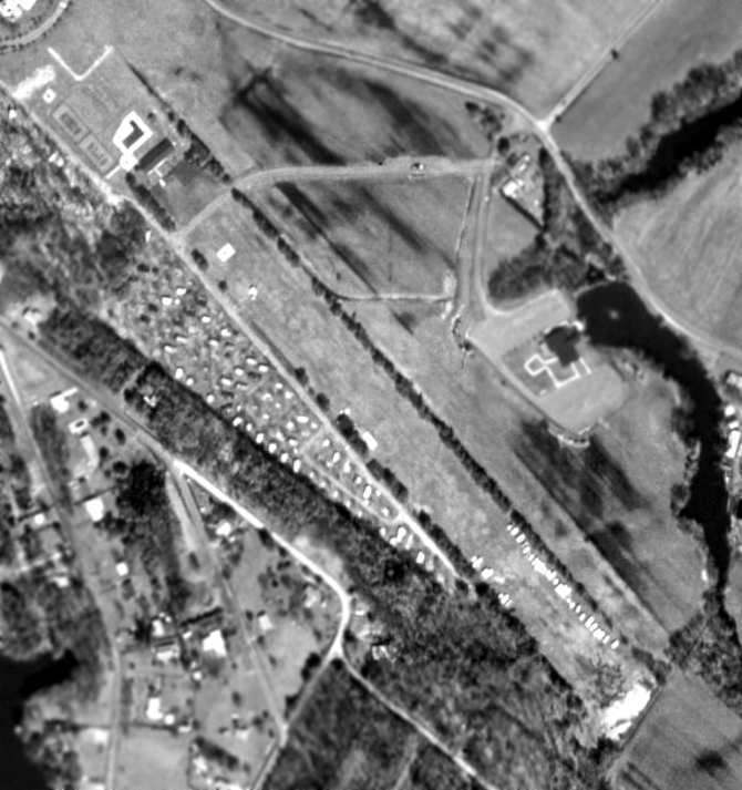
A 1993 aerial view by Ray Tyson looking south at the airfield (the outline of which has been annotated), which was evidently also known as “Nottingham Field”.
A 1994 USGS aerial photo showed the site of Port Royal AAF appeared to have reverted to a cultivated field, and not a trace remained of the former runway.
A 10/25/13 aerial view looking east showed no trace remaining of Port Royal AAF.
The site of Port Royal AAF is located south of the intersection of Route 301 & Route 17.
____________________________________________________
Moss Neck Army Airfield #3 / Pender Army Heliport, Moss Neck, VA
38.215, -77.309 (South of Washington, DC)
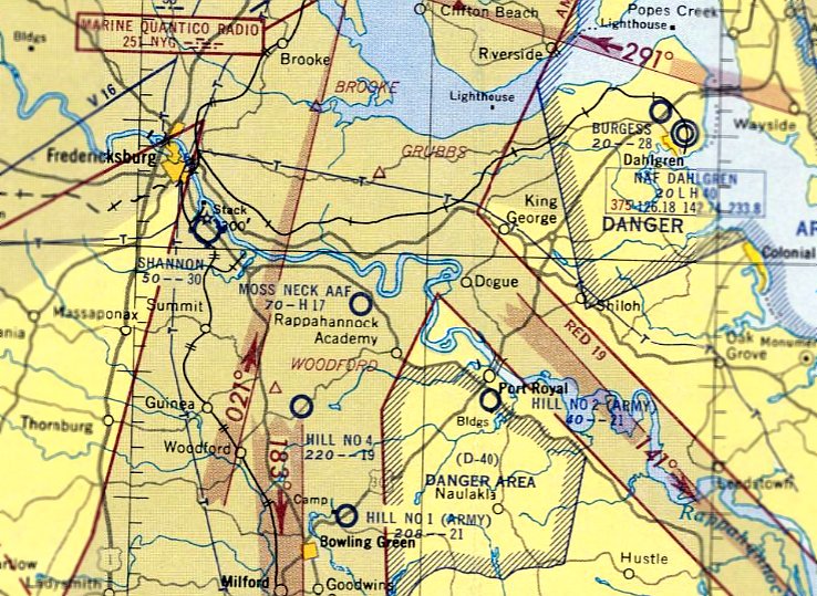
"Moss Neck AAF", as depicted on the January 1954 Washington Sectional Chart.
Photo of the airfield while in use has not been located.
The 76,000-acre Fort A. P. Hill was established as an Army training facility on 6/11/41.
During World War II, the Fort operated as a training site for corps & division-sized units.
The third of what would eventually total 4 airfields within the bounds of the Fort
was evidently established at some point between 1948-52,
as it was not yet depicted on the 1944 USGS topo map nor the October 1948 Washington Sectional Chart (courtesy of Chris Kennedy).
The earliest depiction of Moss Neck AAF which has been located was on the 1952 USGS topo map.
It depicted “Moss Neck Airstrip” as having 2 runways, with 2 small buildings northeast of the runway intersection.
Moss Neck AAF was not yet depicted on the July 1953 Washington Sectional Chart.
The earliest aeronautical chart depiction of Moss Neck AAF which has been located was on the January 1954 Washington Sectional Chart.
It described the field as having a 1,700 hard surface runway.
This would have made it the only one of the 4 A. P. Hill Army Airfields to have had a paved runway,
but this may have been an error on the part of the mapmakers, as it was not repeated by later charts.
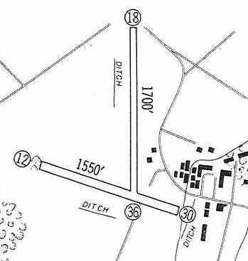
"Moss Neck AAF (#3)" was depicted on the 1960 Jeppesen Airway Manual (courtesy of Chris Kennedy)
as having 2 unpaved runways: a 1,700' Runway 18/36 & a 1,550' Runway 12/30.
Two small buildings (hangars?) were depicted northeast of the runway intersection, but the field was described as unattended.
Moss Neck AAF #3 (and the other 3 Camp AP Hill Army Airfields), as depicted on the 1963 USGS topo map.
The earliest photo which has been located of Moss Neck AAF was a 1963 aerial view.
It depicted Moss Neck as having 2 grass runways, with 2 small buildings northeast of the runway intersection.
There were no aircraft visible on the field.
The October 1964 Washington Sectional Chart (courtesy of Chris Kennedy)
depicted "Moss Neck AAF #3" as having a 1,700' unpaved runway.
A 1966 aerial photo still depicted the 2 runways as remaining clear,
but the small buildings on the northeast side appeared to have been removed at some point between 1963-66.
A 1967 aerial photo depicted Moss Neck in an unchanged configuration.
Moss Neck AAF was still depicted as an active airfield on the April 1969 Washington Sectional Chart (according to Chris Kennedy).
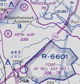
At some point between 1969-77, the field was downgraded to a heliport, and renamed "Pender AHP",
which is how it was depicted on the March 1977 Washington Sectional Chart (courtesy of Chris Kennedy).
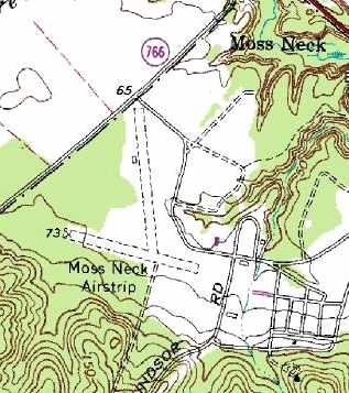
The 2 runways were still depicted as "Moss Neck Landing Strip" on the 1984 USGS topo map.
The last map depiction of the airfield which has been located was on the 1989 USGS topo map,
which depicted the 2 runways as the "Moss Neck Landing Strip".
The Pender Army Heliport was evidently closed at some point between 1977-93,
as it is no longer depicted at all on the March 1993 Washington Sectional Chart (courtesy of Carl Taylor).
As seen in the 1994 USGS aerial photo, the 2 unpaved runways of the former Moss Neck AAF were still completely intact,
but there was no sign of any recent use of the airfield.
The 2001 USGS topo map continued to depict “Moss Neck Airstrip” as having 2 unpaved runways.
In a 2005 aerial photo, the 2 unpaved runways of the former Moss Neck AAF were still completely intact,
but there was no sign of any recent use of the airfield.
The site of Pender AHP is located west of the intersection of Pender Drive & Route 17, at the very northern tip of the Fort A. P. Hill property.
____________________________________________________
Reno Skypark, Colonial Beach, VA
38.213, -77.013 (South of Washington, DC)
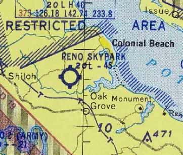
Reno Skypark, as depicted on the August 1957 Washington Sectional Chart (courtesy of Chris Kennedy).
This small general aviation airport was apparently built at some point in 1956,
as it was not yet depicted on the January 1956 Washington Sectional Chart (according to Chris Kennedy).
The earliest reference to the Reno Skypark which has been located
was in the 4/5/56 issue of the "Potomac Interest" newspaper (courtesy of Orville Ingram).
The article read, “The new 'Reno Sky Port', an airfield for Colonial Beach, is now being used.
The new airport, 3.5 miles from Colonial Beach, on land belonging to Walter Massey, was put in use last week.
They have a runway one mile long, which will eventually enable any type plane to land on the field.
A telephone will soon be installed so that any plane using the field can obtain transportation.
Also aviation gasoline will be available & a hangar will be built.
Work has already started on getting the runway in shape.
Additionally work will be done in the near future to permit the full use of the field.
One or more regularly scheduled airlines are interested in running 'Champagne Flights' to Colonial Beach.
The new airfield is owned by Reno Pier. They have been interested in locating an airfield at Colonial Beach for some time."
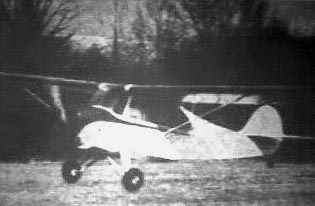
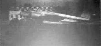
An undated photo (courtesy of Orville Ingram) of the 1st plane to land at Reno Skypark (an Aeronca?).
It was flown from Richmond by Dennis Conner & Jimmy Dyson.
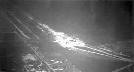
An undated aerial view of what appear to be several planes & a small hangar at Reno Skypark,
with the runway extending toward the top-right (courtesy of Orville Ingram).
An undated photo (courtesy of Orville Ingram) of a twin-engine 18-seat Boeing 247D, painted pink, charcoal gray, and beige.
It was purchased in August 1956, and was first used in the Fall of 1956 for "Champagne Flights" from Colonial Beach to Washington National Airport.
Three of the 4 Conner brothers that ran the Reno Air Park were Denning, Delbert and Paul.
The 7/12/56 issue of the "Potomac Interest" newspaper (courtesy of Orville Ingram) described,
“On Tuesday, July 24, a charter flight of 2 DC-3s will fly into Reno Airpark from Alexandria.
They will be carrying more that 50 passengers between them.
This marks the first commercial flights into Reno Skypark.
After spending several hours at the Beach they will return to Alexandria late Tuesday night.
Lights for night take offs and landings are now being installed at the Airport.”
The 9/13/56 issue of the "Potomac Interest" newspaper (courtesy of Orville Ingram) described,
“Delbert Conner, of Reno, Inc., bought a new twin-motor Apache 4-passenger plane last week.”
The earliest chart depiction of Reno Skypark which has been located
was on the August 1957 Washington Sectional Chart (courtesy of Chris Kennedy).
It depicted the field as having a 4,500' unpaved runway.
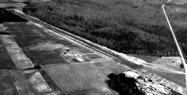
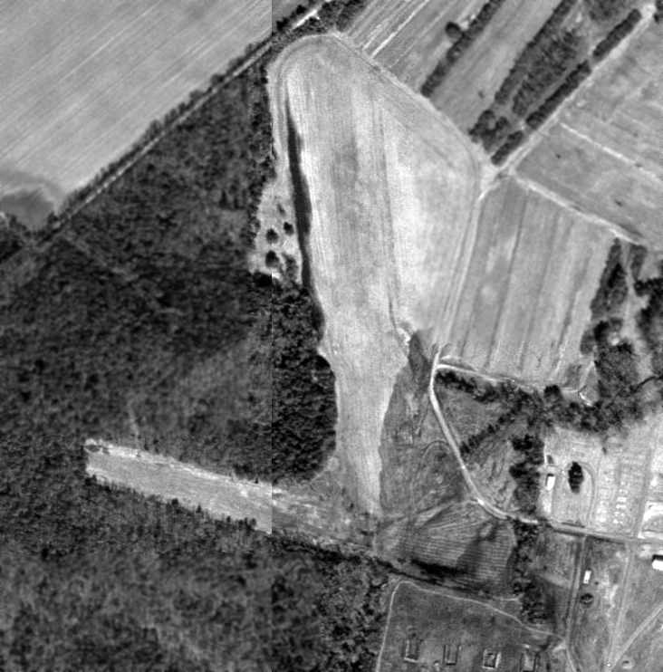
An undated aerial view looking north at the Reno Skypark.
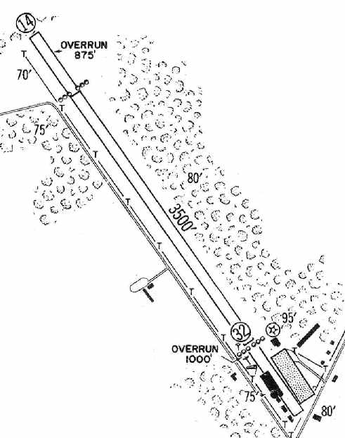
The most detailed depiction which has been located of the Reno Skypark
was in the 1960 Jeppesen Airway Manual (courtesy of Chris Kennedy).
It depicted the field as having a single 3,500' unpaved Runway 14/32, along with 875' & 1,000' overruns.
Several buildings were depicted at the southeast end of the runway.
A 2/20/60 USGS aerial view depicted Reno Skypark as an unpaved northwest/southeast runway with a few small buildings on the southeast side.
There were no aircraft visible on the field.
The last chart depiction which has been located of Reno Skypark was on the July 1960 Washington Sectional Chart.
The Aerodromes table described the field as having a single 3,500' turf runway.
Reno Skypark was not depicted on the 1961 USGS topo map.
Reno Skypark was evidently closed (for reasons unknown) at some point between 1960-64,
as it was no longer depicted all on the 1964 Washington Sectional Chart.
A 1967 aerial view depicted a dragstrip covering the former Reno Skypark runway, along with a possible hangar at the southeast end.
The 1971 USGS topo map labeled the Reno Skypark site as “Colonial Beach Dragway”.
Christopher Mallam reported in 2003, “I remember going to my Uncle's house in Colonial Beach about 20 years ago.
Right across the road was an abandoned airport.
At the far end was Colonial Beach Dragway, but across the street, we would play in an old, run-down building that looked like a hangar.”
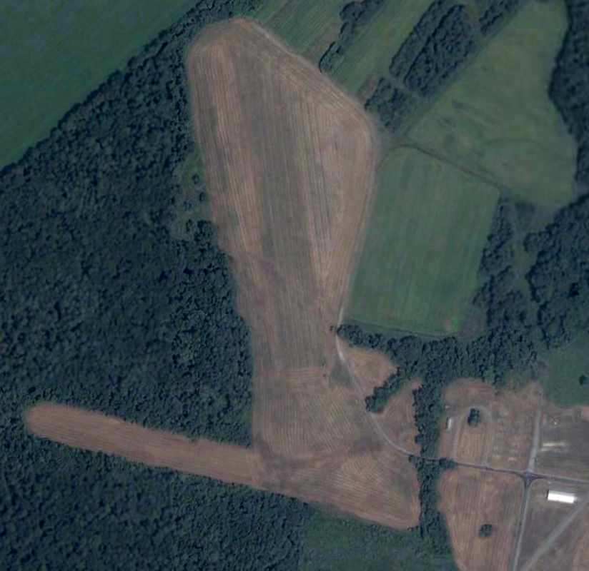
A 2015 aerial view looking north at the Reno Skypark site showed the former runway, reused as a dragstrip.
What appeared to be a former hangar was at the southeast corner of the photo.
An April 2018 photo looking northeast at 2 buildings on the southeast side of the Reno Skypark site, possibly former hangars or other airport buildings.
The site of Reno Skypark is located northwest of the intersection of Route 205 & State Highway 631.
____________________________________________________
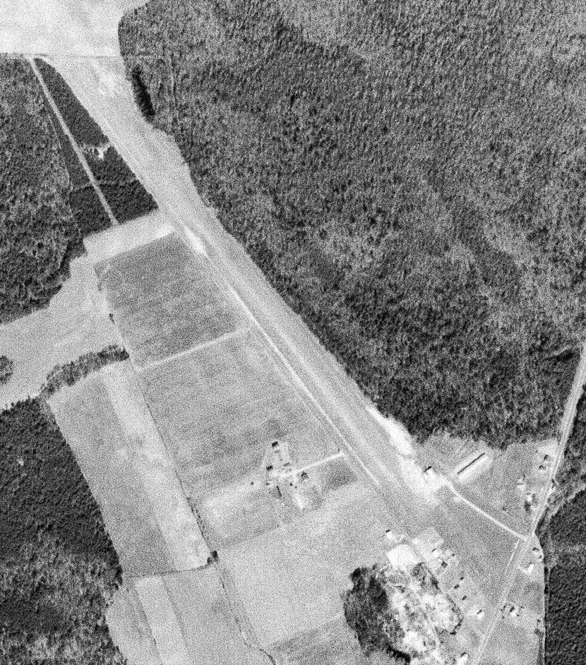
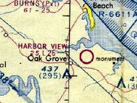
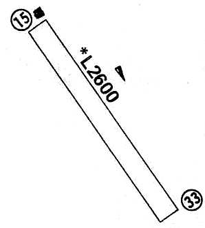
Harbor View Airport, Oak Grove, VA
38.202, -76.975 (South of Washington, DC)
Harbor View Airport, as depicted on the October 1966 Washington Sectional Chart.
This small general aviation airport was apparently built at some point in 1966, as it was not listed in the 1963 AOPA Airport Directory (according to Chris Kennedy),
nor depicted on the 1963 USGS topo map or the March 1966 Washington Sectional Chart.
The earliest depiction of Harbor View Airport which has been located was on the October 1966 Washington Sectional Chart.
It depicted Harbor View as having a 2,600' unpaved runway.
The earliest photo of Harbor View Airport which has been located was on a 1967 aerial photo.
It depicted the field as having a single northwest/southeast grass runway. No aircraft were visible on the field.
The 1970 VA Airport Directory (courtesy of Stephen Mahaley)
described Harbor View Airport as having a single 2,600' turf Runway 15/33.
It listed the operator as the Harbor View Yacht Club, and the manager was listed as Don Davis.
The 1971 USGS topo map depicted “Harbor View Airport” as having a single northwest/southeast runway.
Merton Meade recalled, “Harbor View was a lovely wee strip.
I went down there in the late Tom Selby's Fairchild 25 once. I had lunch nearby. Very nice grass.”

A 6/15/73 aerial view by Kenneth Keeton looking northwest along Harbor View's Runway 33.
Harbor View Airport, as depicted on the 1975 Washington Sectional Chart (courtesy of Ed Drury).
The 1976 AOPA Airport Directory (courtesy of Chris Kennedy) described Harbor View as having a single 2,600' turf Runway 15/33,
and described the field as unattended.
Harbor View Airport was still listed as an active airfield in the 1979 Flight Guide (courtesy of Chris Kennedy).
The last aeronautical chart depiction which has been located of Harbor View Airport was on the March 1981 Washington Sectional Chart.
It depicted Harbor View as having a 2,600' unpaved runway.
The 1985 USGS topo map depicted “Harbor View Airport” as having a single northwest/southeast runway.
Harbor View Airport was apparently closed (for reasons unknown) at some point between 1981-86,
as it was no longer depicted on the August 1986 Washington Sectional Chart nor listed in the 1986 Flight Guide (according to Chris Kennedy).
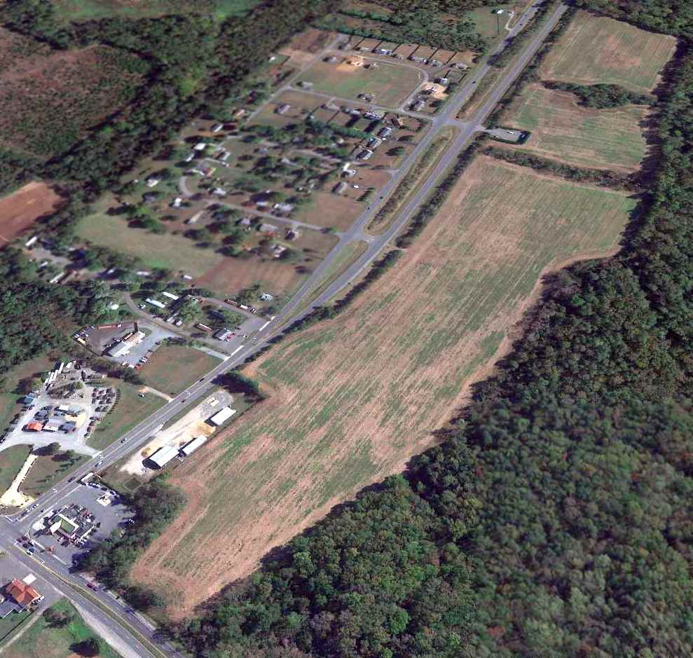
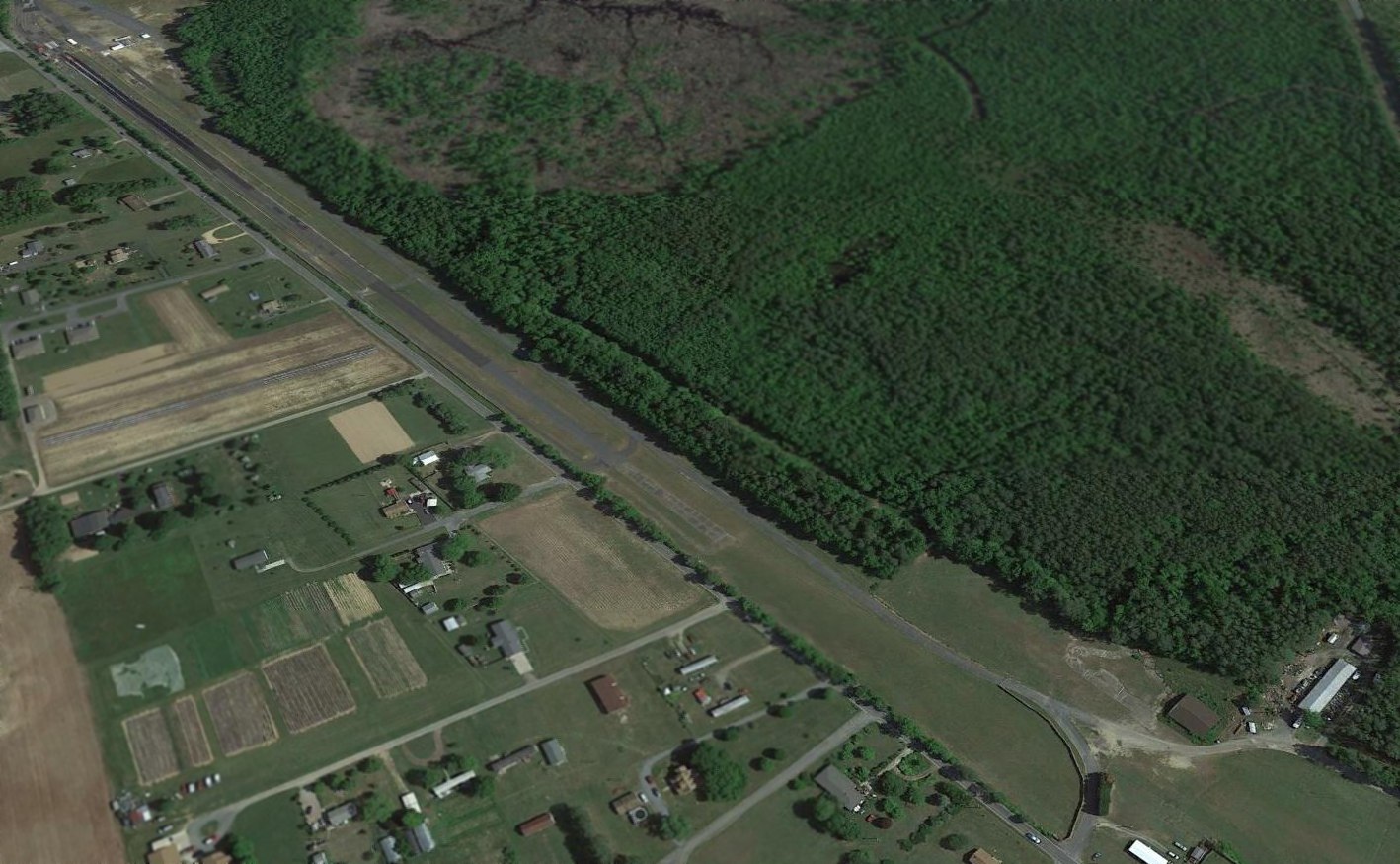
In the 1994 USGS aerial photo (taken after the field's closure), most of Harbor View's runway remained intact,
but a road & several buildings had been built over the northwest portion.
However at least 2 light single-engine aircraft appeared to be parked on the southern end of the runway,
along with a large number of other objects (trailers?).
A 10/25/13 aerial view looking northwest showed the majority of Harbor View's runway to remain intact, but without any sign of recent aviation usage.
The site of Harbor View Airport is located northwest of the intersection of Route 664 & Oak Lane.
____________________________________________________
Since this site was first put on the web in 1999, its popularity has grown tremendously.
If the total quantity of material on this site is to continue to grow,
it will require ever-increasing funding to pay its expenses.
Therefore, I request financial contributions from site visitors,
to help defray the increasing costs of the site
and ensure that it continues to be available & to grow.
What would you pay for a good aviation magazine, or a good aviation book?
Please consider a donation of an equivalent amount, at the least.
This site is not supported by commercial advertising –
it is purely supported by donations.
If you enjoy the site, and would like to make a financial contribution,
you
may use a credit card via
![]() :
:
Please consider checking the box to make a monthly donatation.
For a mailing address to send a check, please contact me at: paulandterryfreeman@gmail.com
If you enjoy this web site, please support it with a financial contribution.
please contact me at: paulandterryfreeman@gmail.com
If you enjoy this web site, please support it with a financial contribution.
____________________________________________________
This site covers airfields in all 50 states.