Abandoned & Little-Known Airfields:
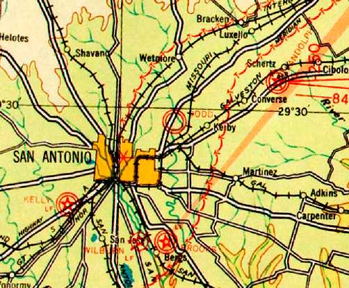
Texas - Southeastern San Antonio area
© 2002, © 2021 by Paul Freeman. Revised 6/22/22.
This site covers airfields in all 50 states: Click here for the site's main menu.
____________________________________________________
Please consider a financial contribution to support the continued growth & operation of this site.
Brooks Field / Brooks AFB (revised 6/22/22) - Cuero Field / Brayton Flying Field (revised 9/30/18) - Martindale AAF (revised 11/4/20)
____________________________________________________
Cuero Field / Brayton Flying Field, Cuero, TX
29.13, -97.3 (Southeast of Austin, TX)
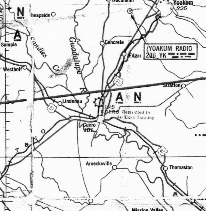
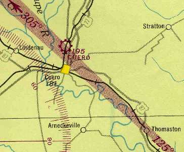
Cuero Field, as depicted on the April 1942 San Antonio Sectional Chart (courtesy of Ron Plante).
The airfield at Cuero Field was evidently not a pre-WW2 civilian airport,
but rather was purpose-built for the military flight training school,
as no airfield at the site was listed in the Airport Directory Company's 1937 Airports Directory (courtesy of Bob Rambo).
According to the The Handbook of TX Online,
Cuero Field was approved by the government as a primary training facility in January 1941 & established on 2/6/41.
It was operated by Brayton Flying Service (directed by Clyde Brayton),
which conducted a contract flying school for military aviators.
According to a historical marker commemorating Brayton Flying Field,
“Clyde Brayton [was a] veteran pilot whose first licenses (1926-1931) were signed by air pioneer Orville Wright.
Cuero provided land, Brayton put in facilities & enrolled the first class in March 1941.
A staff of 550 civilians & 100 military men trained 6,611 students who flew 335,000 hours.
The field received awards for safety & meritorious service.”
The earliest aeronautical chart depiction which has been located of Cuero Field
was on the April 1942 San Antonio Sectional Chart (courtesy of Ron Plante).
It noted Cuero as being “Restricted to Air Corp Training”.
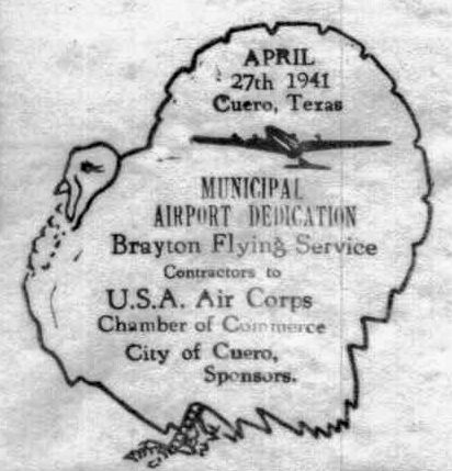
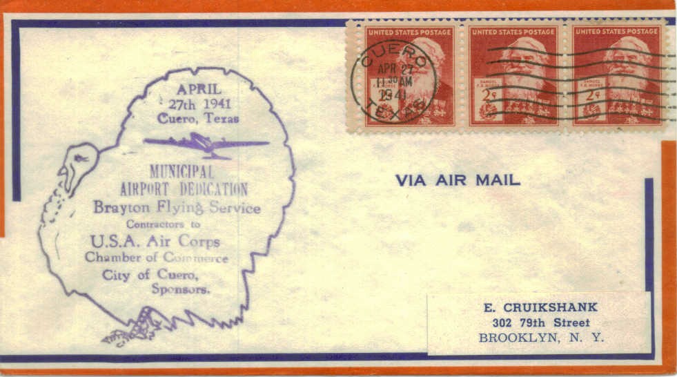
A postmark commemorated the 4/27/41 Municipal Airport Dedication of Brayton Flying Service.
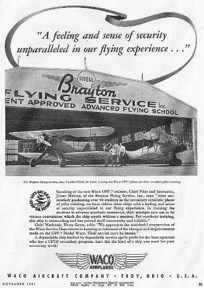
The earliest photo which has been located of Cuero Field
was an undated picture of 2 Waco UPF-7 biplane trainers in front of the Brayton Flying Service hangar
in a November 1941 advertisement for the Waco Aircraft Company.
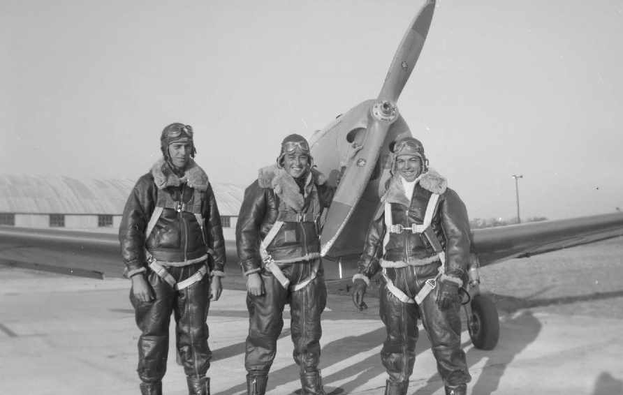
A circa 1942 photo (courtesy of Jim Rader) of a group of pilots (one of which may be Milton Tucker)
in front of a Fairchild PT-19 at Cuero Field.
All instructors & mechanics at Cuero Field were civilian,
though the army rigidly supervised the training.
The 9 week course included classes in meteorology, navigation, aircraft identification, and aircraft engines.
Training included 5 hours on the Link trainer (an early flight simulator)
and 65 hours actual flying time.
The school's capacity was 290 cadets.
Thousands of pilots who graduated from Cuero Field went on to serve in WW2.
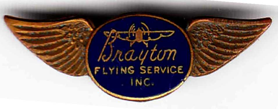
An undated set of wings from Brayton Flying Service (courtesy of Ros King).
The Brayton Flying Service School payroll brought about $145,000 a month into Cuero's economy.
The commanding officers of Cuero Field were Capt. James H. Price
and Majors Shepler W. Fitzgerald & Timothy F. O'Keefe.
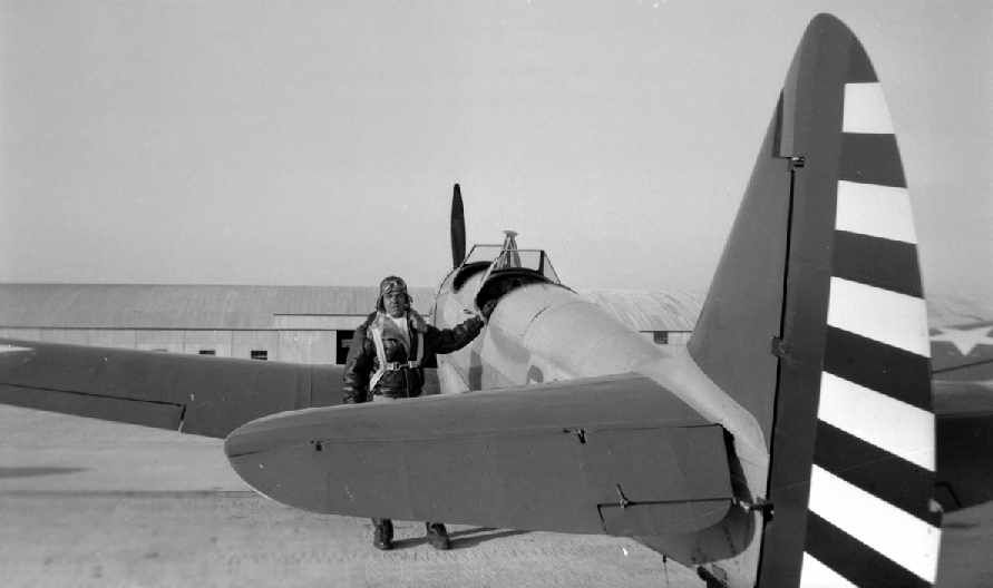
A circa 1942 photo (courtesy of Jim Rader) of Milton Tucker, of Cuero Field's Class 43-D, posing with a Fairchild PT-19.
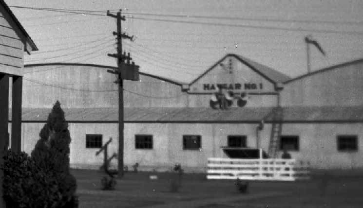
A circa 1942 photo (courtesy of Jim Rader) of Cuero Field's Hangar 1.
Tom Beamer passed along a description of Cuero Field,
from the official history of the Aeronautical Training Society
(the organization formed by the civilian operators of the USAAF Primary Training Schools):
Brayton Flying Service was originally established in St. Louis in October of 1933.
The Texas operation was organized in December 1940 & training began in March 1941.
Cuero was built during a period of continuous rain in an area known as "Brayton's Bay",
which was an old ranch & abandoned rice field with no drainage at the time of construction.
The main aerodrome covered 501 acres & had 4 hangars, 7 barracks, and 10 other buildings.
There were 4 practice fields totaling an additional 800 acres.
The school had a western motif & decor with cattle horns, spurs, Mexican decoration & furniture.
All indications are that the runways were grass.
The 1943 San Antonio Sectional Chart (courtesy of Chris Kennedy) depicted Cuero as a commercial/municipal field.
A 10/25/43 aerial view looking north from the 1945 AAF Airfield Directory (courtesy of Scott Murdock)
depicted Cuero Municipal Airport as a rectangular grass area with a paved ramp & several buildings on the west side.
The 1944 Directory of Army airfields (courtesy of Joe Benson)
described Cuero Field as having a 5,400' unpaved runway,
and indicated that Army flight operations were conducted from the field.
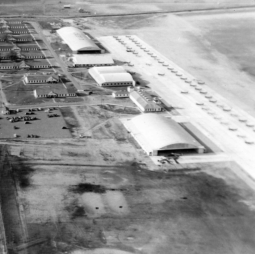
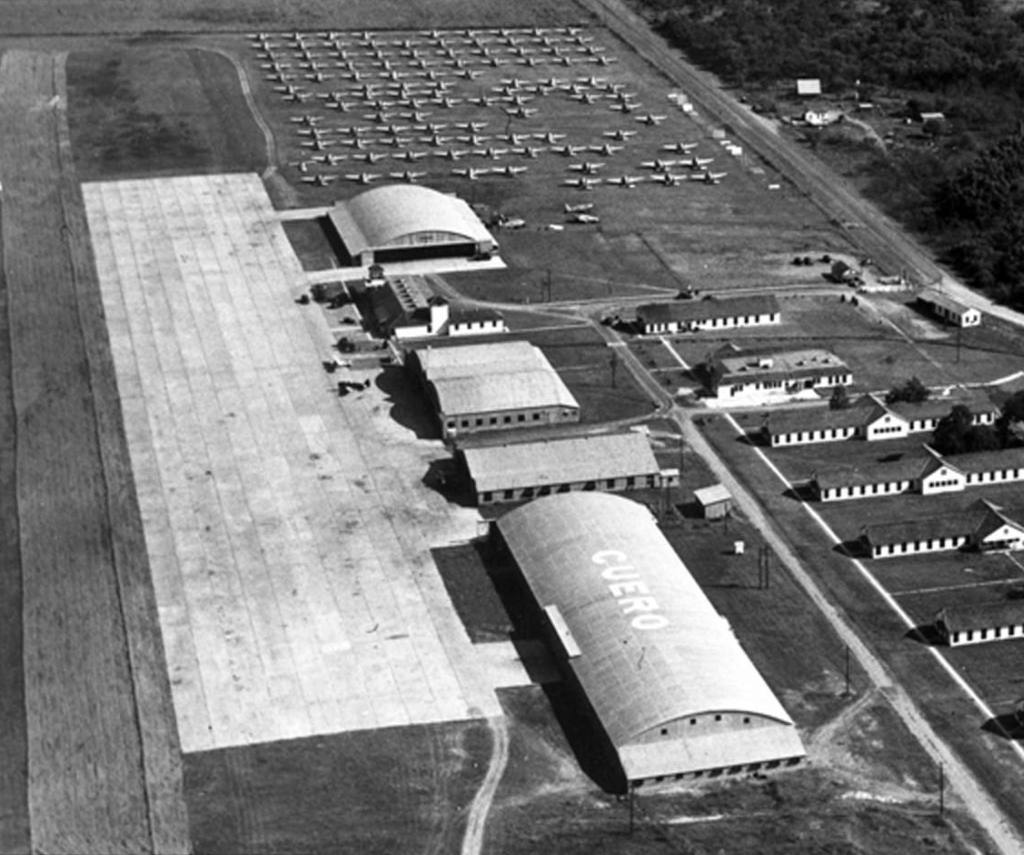
A circa 1944 aerial view (courtesy of Brian Copher) looking northeast at Cuero Field,
showing hangars, the ramp, and dozens of trainer aircraft.
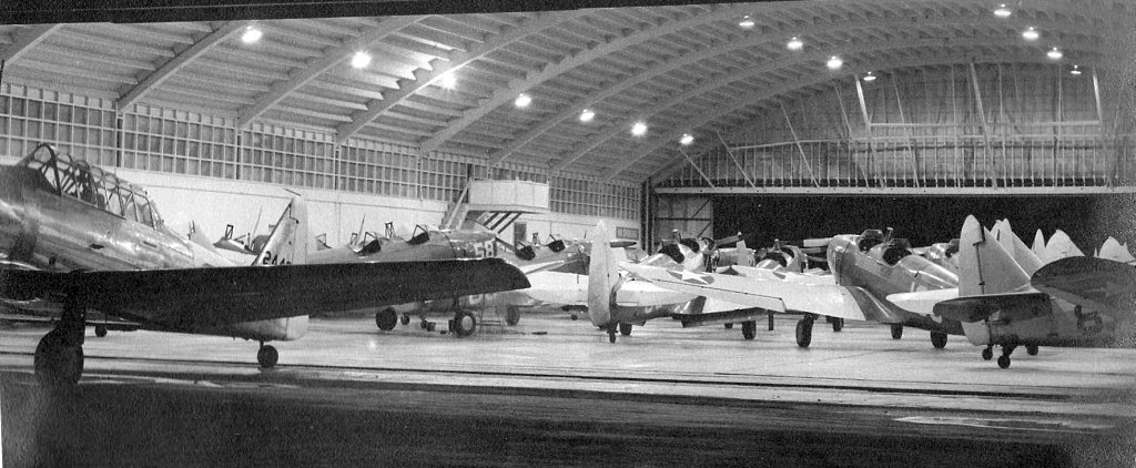
A circa 1944 photo (courtesy of Brian Copher) showing AT-6 Texans & Fairchild PT-19s inside a Cuero hangar.
Flight training operations at Cuero Field were discontinued on 8/31/44.
After the school closed, the government retained one hangar to repair & service Army planes,
and Clyde Brayton moved to Houston to become president of Red Arrow Freight Lines.
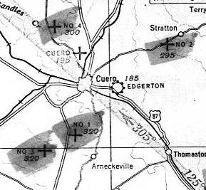
Cuero Field was still depicted as an active airfield on the 1945 San Antonio Sectional Chart (courtesy of John Voss),
along with 4 satellite airfields (simply labeled "No 1", "No 2", "No 3", and "No 4").
The 1945 AAF Airfield Directory (courtesy of Scott Murdock) described Cuero Municipal Airport
as a 501 acre rectangular property having a sod all-way landing field, measuring 5,900' north/south by 3,400' east/west.
The field was said to have 4 hangars, the largest being a 431' x 109' metal structure – remarkably large for the time.
The airport was said to be owned by the City of Cuero, and operated by private interests.
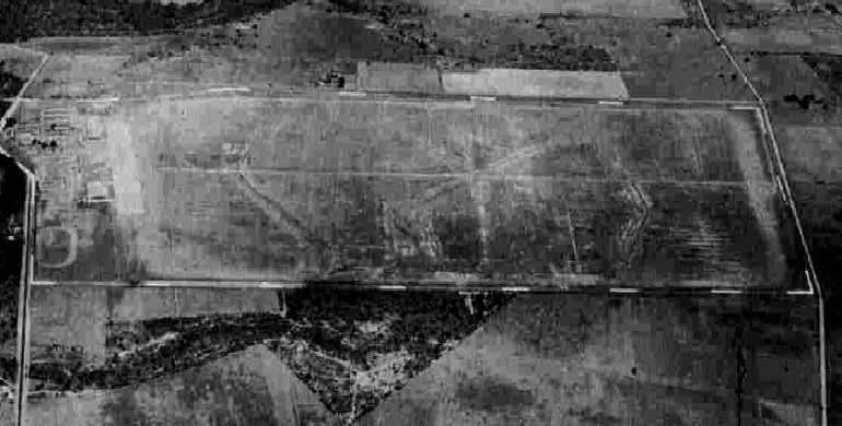
An undated aerial view looking southeast at Cuero Field,
showing a large number of trainer aircraft presumably in storage after the closure of the wartime flight training operation.
Ganey Bradfield recalled, “Regarding the old Army Training Airfield at Cuero,
in the spring of 1946, I ferried a Piper J-3 crop duster conversion to there,
for a crop dusting service based in Portland TX.
At that time the entire Cuero Field, except for the ramp area, was stacked with surplus airplanes,
mostly trainers, such as the Beech AT-7, AT-10, AT-11, the Curtis AT-9, and Cessna UC-78s.
There were 2 hangars there being used.
One hangar was being used to strip instruments & equipment from the AT-9s & AT-10s.
Those airplanes (AT-9 & AT-10) were then moved to the adjacent hangar, cut up & destroyed.
I don't know what was happening to the other Beech & Cessna airplanes there.”
Cuero Field was still depicted as an active airfield on the 1949 San Antonio Sectional Chart (courtesy of Chris Kennedy),
and described as having a 5,300' unpaved runway.
A 4/16/53 USGS aerial view depicted Cuero Municipal Airport as a rectangular grass area with a paved ramp & several buildings on the west side.
Cuero Field was evidently closed at some point between 1949-63,
as it was not listed among active airfields in the 1963 TX Airport Directory (courtesy of Steve Cruse).
By then, it had evidently been replaced by Cuero Municipal Airport,
which was built 2 miles east of the town of Cuero.
Even though Cuero Field had been closed for many years by that point,
the 1981 USGS topo map still depicted a section of a single northwest/southeast runway, labeled "Landing Strip".
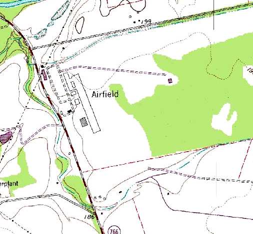
The 1987 USGS topo map labeled the site simply as "Airfield", and depicted the paved ramp & buildings.
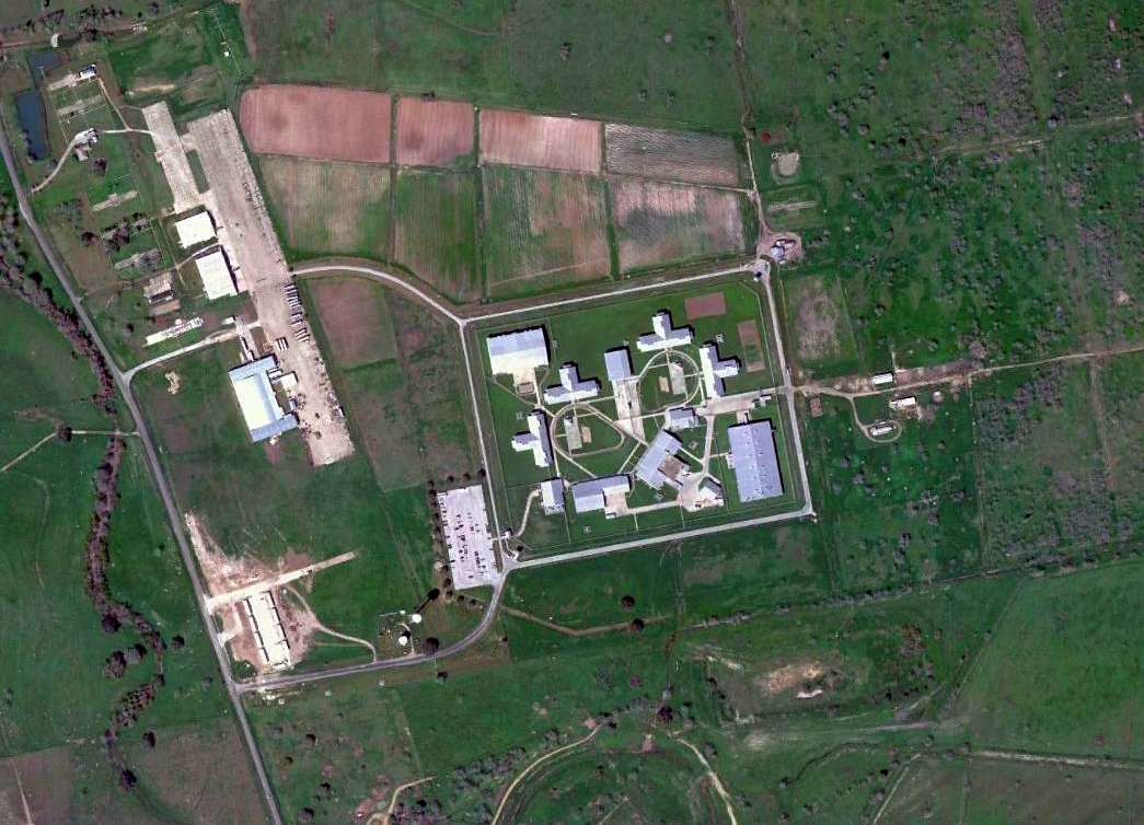
In 1994 the TDCJ Emergency Prison was completed on the center of the former Cuero Field.
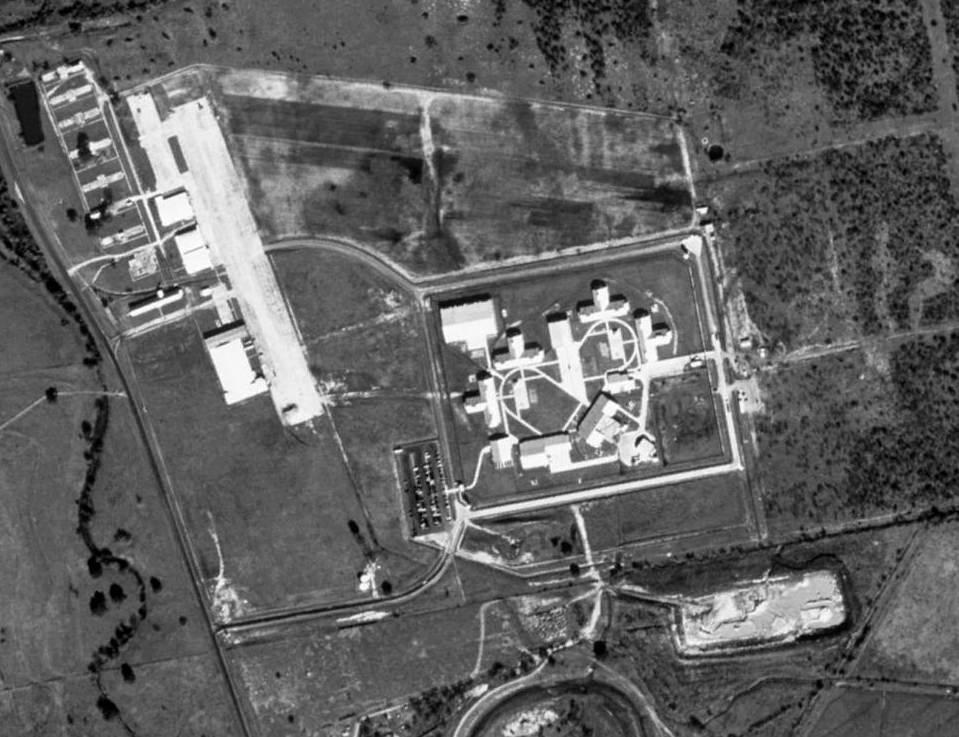
In a 1/22/95 USGS aerial photo, the paved ramp area remained intact,
along with several former hangars & other airfield buildings along the west side of the ramp.
The newly-constructed prison is seen just southeast of the ramp.
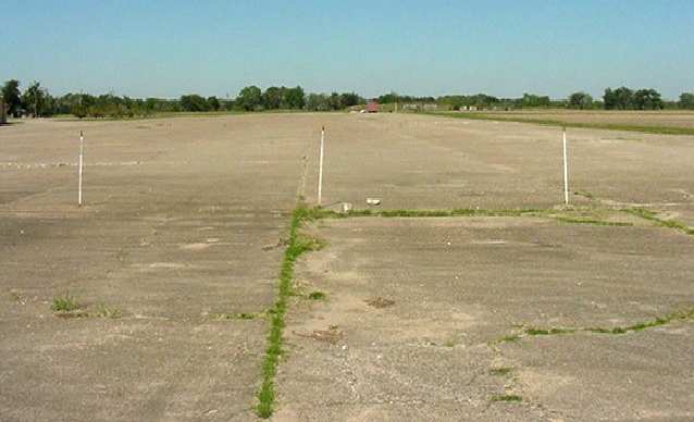
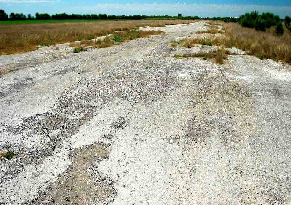
A 2003 photo by Scott Murdock of the remaining ramp at the former Cuero Field.
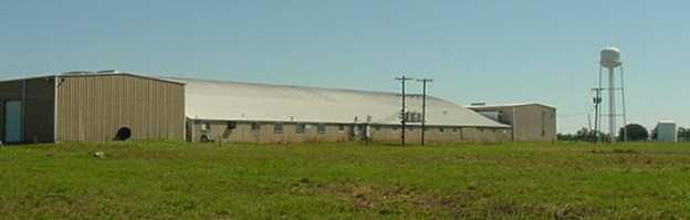
A 2003 photo by Scott Murdock of one of the remaining hangars at the former Cuero Field.
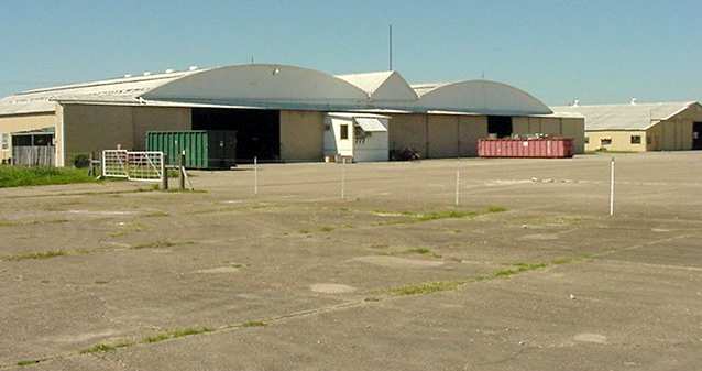
A 2003 photo by Scott Murdock of the remaining ramp at the former Cuero Field.
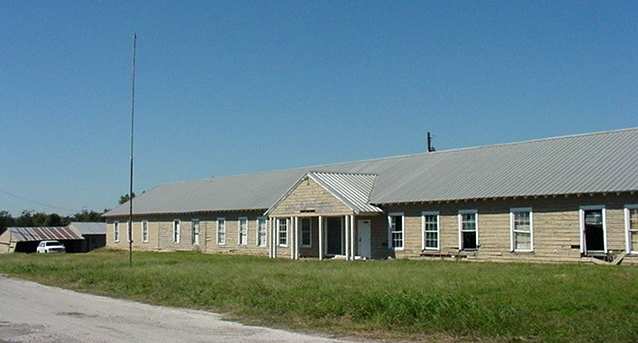
Scott Murdock visited the site of Cuero Field in 2003.
"I was able to set foot on part of the concrete ramp & observe 2 different hangars
and what I believe was the administration building, complete with flagpole.
Part of the actual flying field is now occupied by a prison."
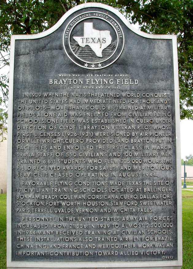
A 4/24/07 photo of a historical marker commemorating Brayton Flying Field.
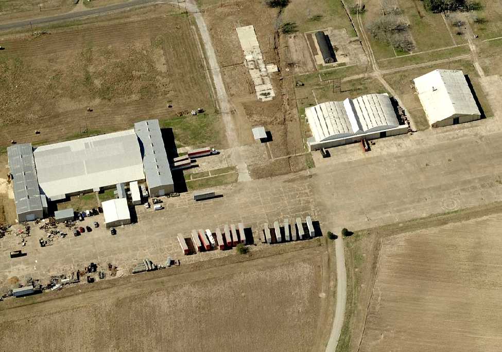
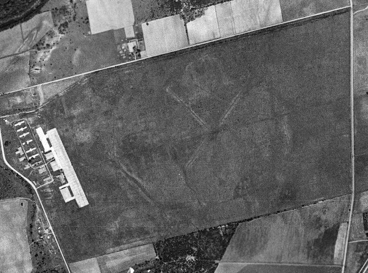
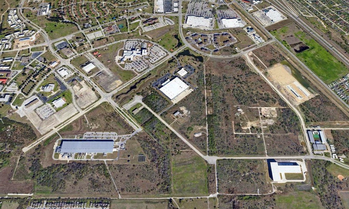
A circa 2010 aerial view looking west at the site of Cuero Field showing the ramp & 4 former hangars remaining intact.
A 3/3/12 aerial photo of the site of Cuero Field showed the ramp & several former hangars remained intact.
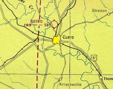
The site of Cuero Field is located southeast of the intersection of Route 766 & Blackwell Road.
____________________________________________________
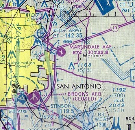
Martindale Army Airfield (MDA), San Antonio, TX
29.43, -98.38 (East of Downtown San Antonio, TX)
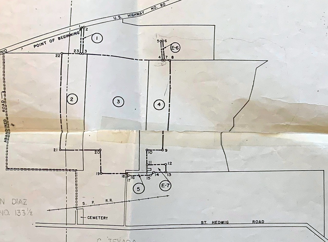
A 9/20/43 War Department property plan of Martindale Auxiliary Field (courtesy of Troy Meuth).
This airfield was built during WW2 as Martindale Auxiliary Army Airfield #4,
to serve as one of 8 satellite airfields for Randolph AAF (10 miles northeast),
which was the largest flight training facility in the world at the start of WW2.
Martindale Field was apparently built at some point in 1943,
as it was not yet depicted on the 1943 San Antonio Sectional Chart (according to Chris Kennedy).
The earliest depiction which has been located of Martindale Field was a 9/20/43 War Department property plan of “Martindale Auxiliary Field” (courtesy of Troy Meuth).

The earliest photo which has been located of Martindale Field was a 10/25/43 aerial view looking north
at “Randolph Field Auxiliary (Martindale Field)” from the 1945 AAF Airfield Directory (courtesy of Scott Murdock).
It depicted Martindale as having 2 paved runways.
The 1945 AAF Airfield Directory (courtesy of Scott Murdock) described “Randolph Field Auxiliary (Martindale Field)”
as a 270 rectangular property having 2 paved 3,000' runways, oriented north/south & northwest/southeast.
The field was not said to have any hangars, to be owned by the U.S. Government, and operated by the Army Air Forces.
The earliest aeronautical chart depiction of Martindale AAF which has been located
was on the 1945 San Antonio Sectional Chart (courtesy of Chris Kennedy).
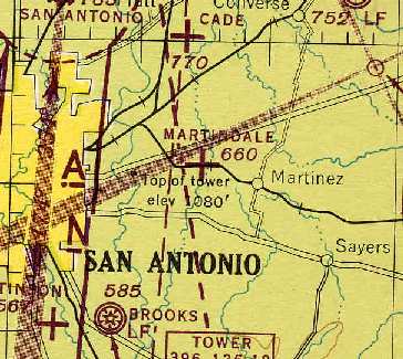
"Martindale AF" was depicted on the 1949 San Antonio Sectional Chart (according to Chris Kennedy)
as having a 3,000' hard-surface runway.
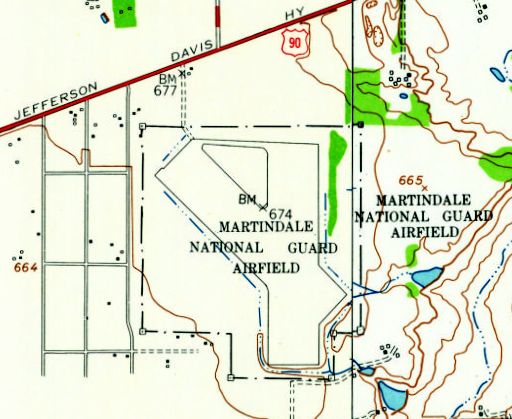
The 1953 USGS topo map depicted "Martindale National Guard Airfield" as having 2 (very wide) paved runways.
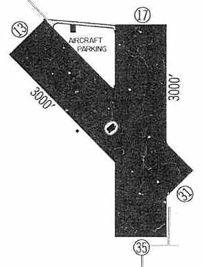
"Martindale AAF (ARNG)" was depicted in the 1960 Jeppesen Airway Manual (courtesy of Chris Kennedy)
as having 2 (very wide) 3,000' paved runways: 13/31 & 17/35.
A 2/1/63 aerial photo showed Martindale to have 2 wide paved runways, with a ramp, hangar, and a single aircraft on the north side.
"Martindale AAF" was still depicted as an active airfield
on the January 1970 San Antonio Sectional Chart (courtesy of Chris Kennedy),
and depicted as having 2 paved runways, with the longest being 3,000'.
The December 1976 San Antonio Sectional Chart (courtesy of Jim Hackman)
depicted Martindale AAF as having 2 paved runways.
The Martindale airfield was apparently abandoned at some point between 1976-83,
as it was labeled as an abandoned airfield on the 1983 USGS topo map.
Martindale was reactivated at some point between 1983-92
by the Texas Army National Guard for helicopter operations.
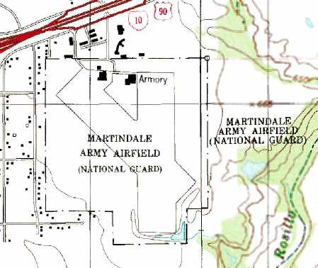
It was labeled "Martindale Army Airfield (National Guard)" on the 1992 USGS topo map.
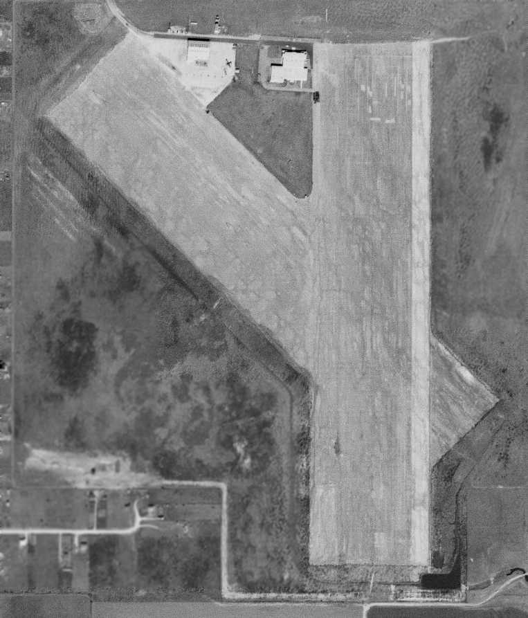
A 1995 USGS aerial view looking south showed Martindale AAF's runways in extremely poor condition.
As of 2003, Martindale was still listed as an active military airfield in the Airfield Facility Directory.
An April 2005 photo by Josh Ream looking south from Martindale's approach end of Runway 17.
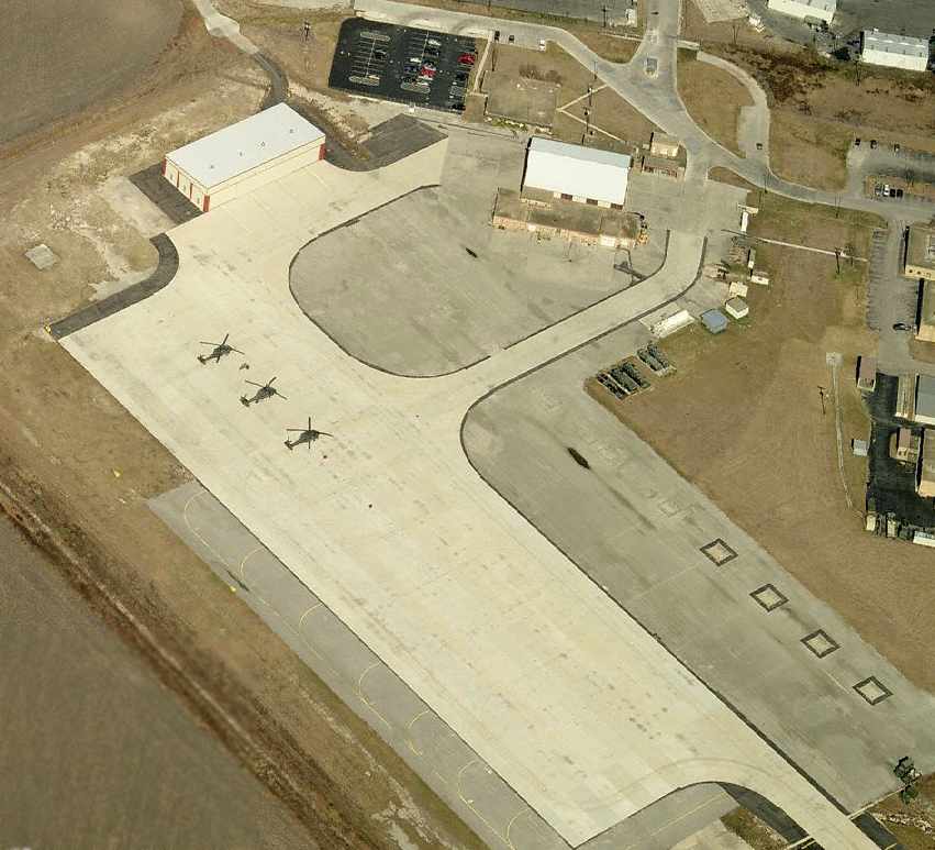
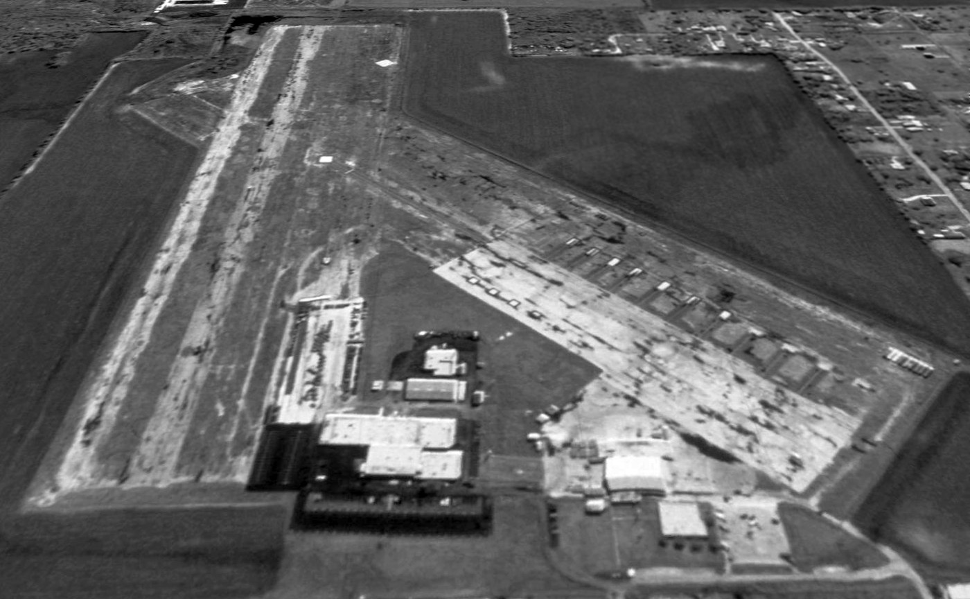
A circa 2006 aerial view looking north at the ramp which has been constructed over Martindale's former Runway 13/31,
showing several TX NG UH-60 Blackhawks.
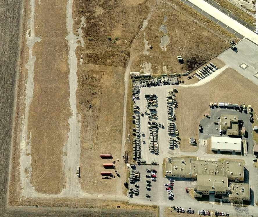
A circa 2006 aerial view looking south, with the remains of Martindale's former Runway 17/35 on the left.
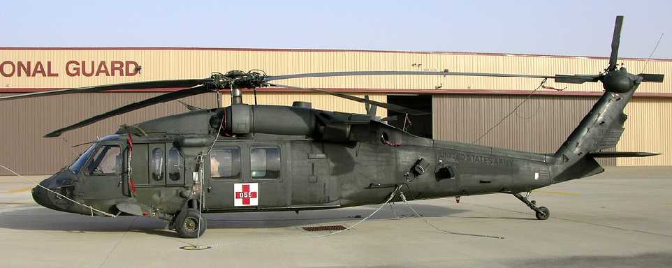
A 1/29/08 photo by Jerry Gunner of a Sikorsky UH-60A (88-26055) of the TX ArNG Company 'C' / 2-149th Aviation (AA) at Martindale AAF.
A 2016 aerial view looking south showed Martindale AAF's ramp area had been extensively renovated,
with multiple new helicopter pads having been built over the northern portion of the former Runway 13/31.
____________________________________________________
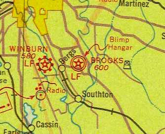
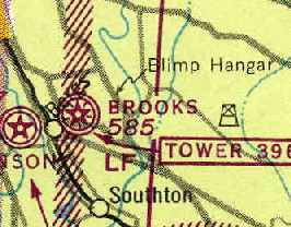
Brooks Field / Brooks AFB, San Antonio, TX
29.34, -98.44 (Southeast of Downtown San Antonio, TX)
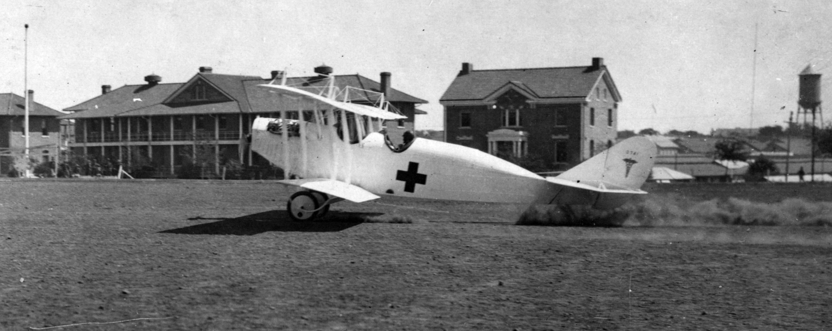
This field was established in 1917 as Gosport Field, a facility to train flight instructors.
It was renamed Brooks Field in 1918. Hangar 9 was built during this period.
A circa 1918 photo of a hangar at Brooks Field (from the Fort Sam Houston Museum, courtesy of David Brooks).
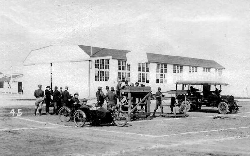
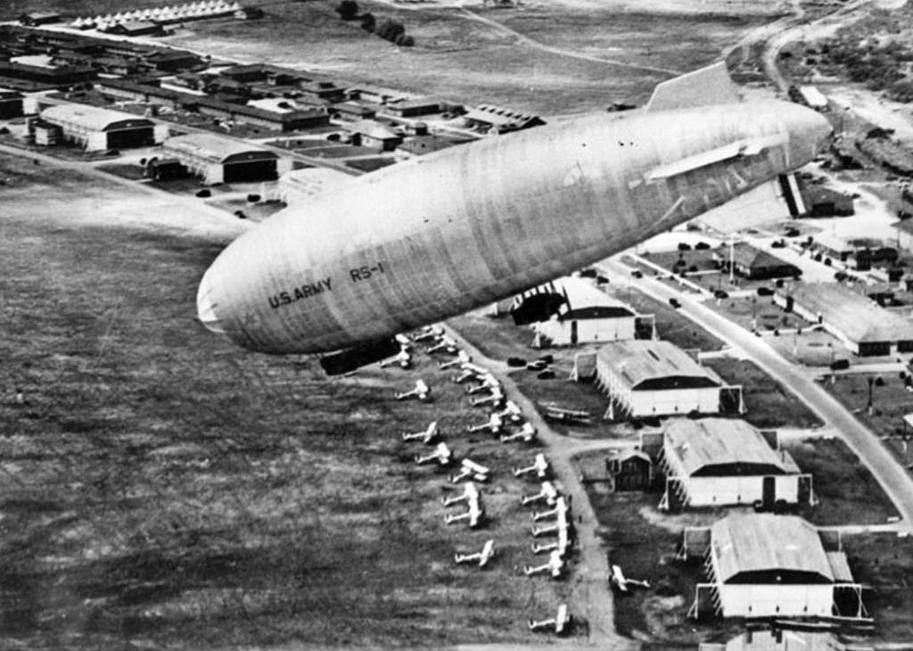
In 1919 the army replaced the pilot school with a balloon & airship school.
The earliest map depiction which has been located of Brooks Field was on the 1919 TIB Military Map of the US (courtesy of Jonathan Westerling).
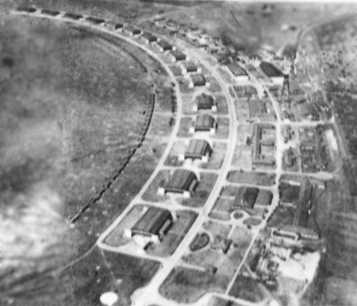
A 1922 aerial view looking southwest at the arc of 16 hangars at Brooks Field.
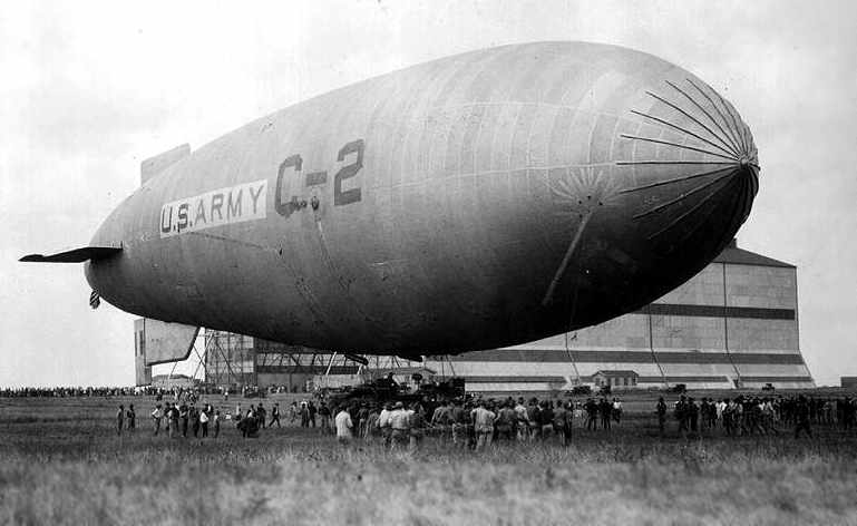
A 1922 photo of the C-2 blimp at Brooks Field (from the Fort Sam Houston Museum, courtesy of David Brooks).
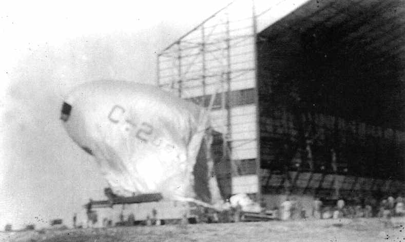
A 1922 photo of the C-2 blimp after it had been blown back against the hangar (from the Fort Sam Houston Museum, courtesy of David Brooks).
The caption on the back of the photo says it burned & was the last time the Army used hydrogen filled LTA craft [thereafter they used helium].
Following a series of accidents, the army closed the balloon & airship school in 1922.
From 1922-1931 Brooks served as the primary flying school for the Army Air Corps.
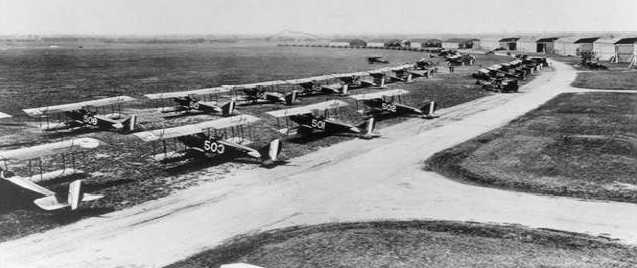
An undated photo of dozens of unidentified biplanes at Brooks Field (courtesy of Rex Ricks).
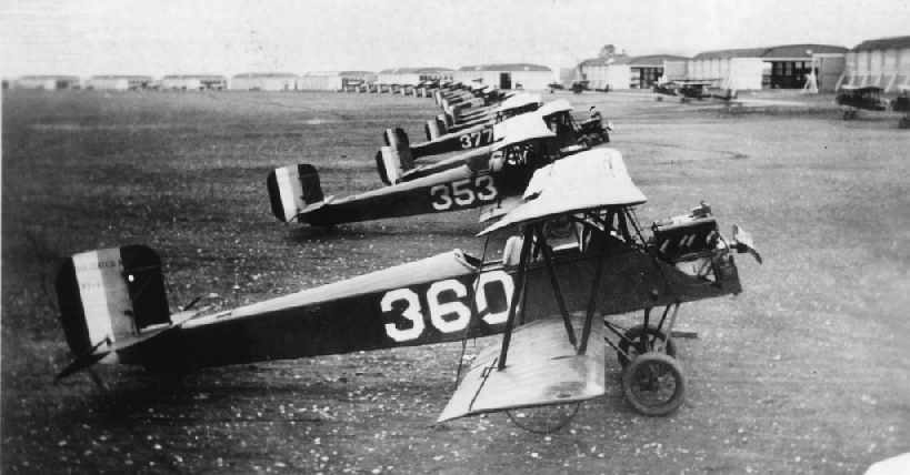
A 1923 photo of a row of PT-1s in front of the hangars at Brooks Field (from the Fort Sam Houston Museum, courtesy of David Brooks).
A 1924 aerial view looking southeast at Brooks Field,
showing the field's original arrangement with an arc of hangars along the north side of the field,
and a dirigible hangar in the center of the grass airfield area.
A colorized circa 1920s-1930s Army Air Corps photo looking northwest at Brooks AAF.
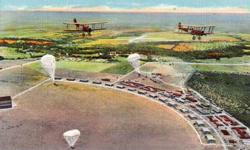
In 1929, Brooks was the site for the first successful mass parachute drop in the world.
The concept, conceived & implemented at Brooks,
confirmed the practicality of tactical paratrooper warfare.
Brooks Field, as depicted on the 1929 Beaumont – San Antonio Airway Map # 27 (courtesy of David Brooks).
Brooks Field, as depicted on the 1934 San Antonio Sectional Chart.
During the 1930s, Brooks was the center of aerial observation activity & several units were trained in tactical observation.
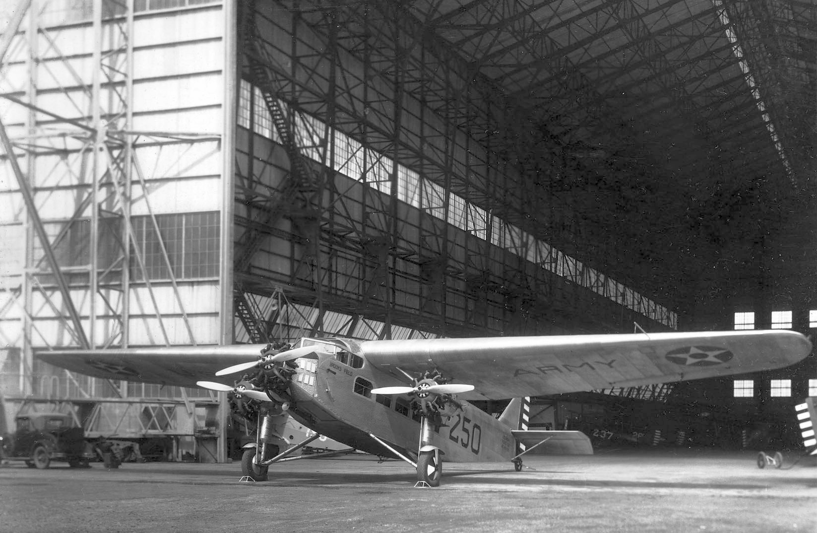
A circa 1930s USAAC photo of a Ford C-9 Tri-Motor (S/N 29-225) in front of Brooks Field's blimp hangar.
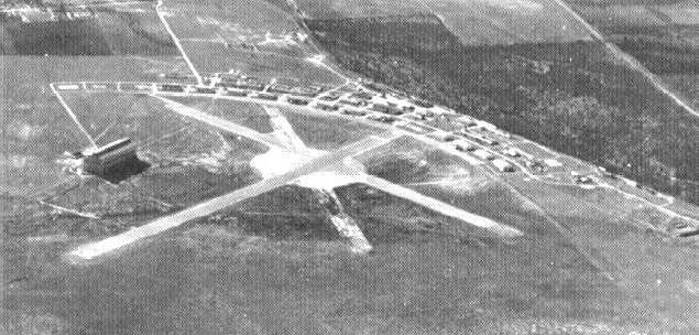
A 1939 aerial view looking northwest at Brooks Field,
showing the addition of 3 paved runways in the center of the airfield.
In 1940, Brooks became the site for a special school for combat observers.
In 1941, advanced training in piloting single-engine aircraft was conducted
with emphasis on aerial observation skills.
A 5/15/43 AAF list of airfields of the Gulf Coast Training Center (courtesy of Ron Plante)
described Brooks Field as having 3 concrete runways, with the longest being the 5,100' northeast/southwest strip.
It listed Brooks as having 4 satellite fields:
Yturri Auxiliary, Dilts Auxiliary, Kelley 2 Auxiliary, and Kelly 4 Auxiliary.
Observation training at Brooks Field was discontinued in 1943,
when Brooks became the home for training pilots in the new B-25 bomber.
This remained the mission of the base for the rest of World War II.
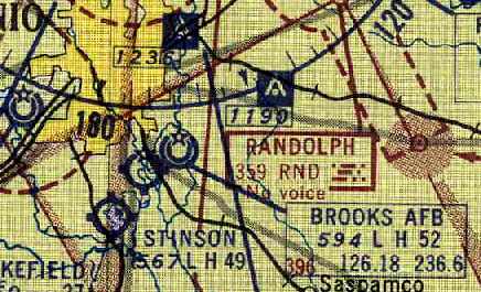
Brooks AAF, as depicted on the June 1943 San Antonio Sectional Chart (courtesy of Chris Kennedy).
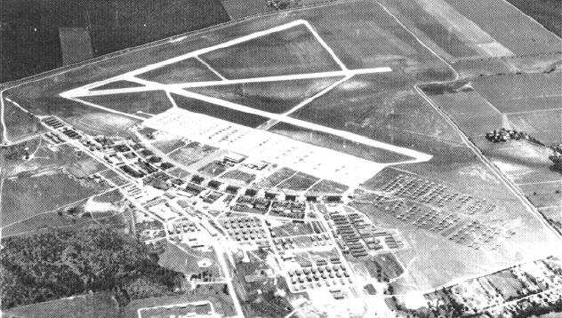
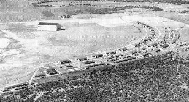
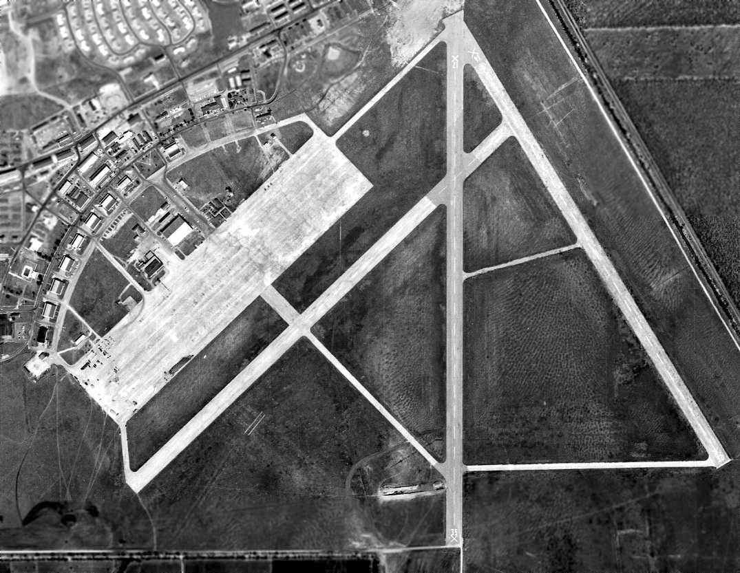
A 1945 aerial view looking southeast at Brooks Field,
showing the radically reconfigured WW2 layout of the field,
and 3 new runways having been built somewhat further to the south.
The dirigible hangar had been removed at some point between 1939-45.
A 1946 map depicted Brooks AAF as having 3 paved runways (courtesy of Rex Ricks).
When pilot training at Brooks Field concluded at the end of World War II,
the base took on a new mission.
In 1951 in the midst of the Korean War, the Air Force established a reserve training center at Brooks.
The 907th Air Reserve Wing was assigned to the base.
Conceived originally as a troop carrier unit, the wing did not receive its first planes until the summer of 1952.
The planes were T-6 Texans, an indication of the 907th's new mission, pilot training.
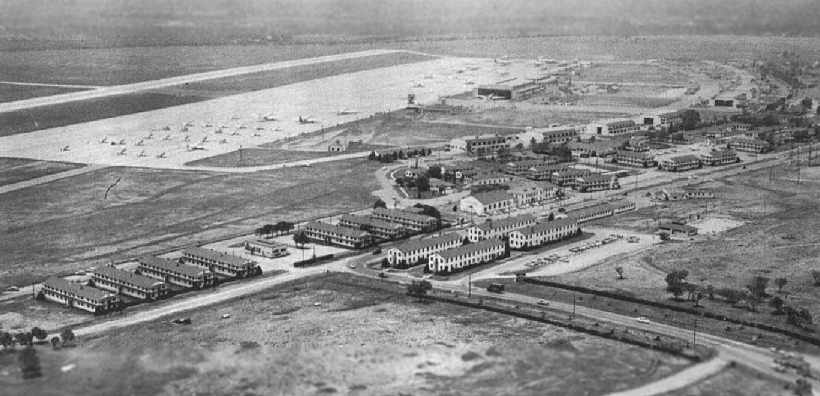
A circa 1952-54 aerial view looking south at the ramp at Brooks AFB (from the Fort Sam Houston Museum, courtesy of David Brooks).
Almost before it began its new mission,
the 907th Air Reserve Wing was replaced by the 8707th Pilot Training Wing (Single-Engine).
On the first anniversary of its activation, the 8707th had 6 T-6s & 2 C-46 Commandos assigned.
That began to change in April 1953 when the wing acquired its first five North American T-28s.

The 1953 USGS topo map depicted Brooks AAF as having 3 paved runways.
In 1954 Colonel David "Tex" Hill, a fighter pilot who made his reputation as a member of Chennault's Flying Tigers,
took over the 8707th Pilot Training Wing's pilot training program.
At year's end the wing converted to C-46s & the 8707th was replaced by the 433d Troop Carrier Wing.
In 1956 reservists celebrated their 5th anniversary at Brooks
with the arrival of another aircraft, the C-119 transport.
Four years later, the 433rd Troop Carrier Wing moved to Kelly AFB.
From the time the Reserve first established a wing at Brooks in 1951,
whatever the numerical designation, the people of San Antonio have always referred to the unit as the Alamo Wing.
Brooks AFB was depicted on the August 1954 Edward's Plateau World Aeronautical Chart (courtesy of Chris Kennedy)
as having a 5,200' hard-surface runway.
Starting in the summer of 1959, Brooks began a transition from a flight-training base to a center
for medical research, development, and education.
An era in aviation history ended in 1960, when the last plane took off from Brooks.
The aircraft was a C-131 Samaritan piloted by Col. L.B. Matthews,
commander of Det. 1, 1st Aeromedical Transport Group.
A 2/5/63 aerial photo showed the expansive airfield at Brooks shortly after the closure of its aviation operations.
The runways of the base were still depicted on the December 1976 San Antonio Sectional Chart (courtesy of Jim Hackman),
but it was labeled as "Brooks AFB (Closed)".
Jack Lewis recalled, “My first duty station was Brooks Field.
I was with the 6906th Electronic Security Squadron on the back side of the base.
I was one of the 2.5 ton truck driving instructions & we used the runway (closed) at Brooks for drivers' training.
Brooks also had an electronically monitored little building about 25 - 30 yards from our building.
It was part of the aerospace medicine school there
and rumor had it that Moon rocks and other 'off-world' stuff was stored there.
It had a fence with vibration sensors around it.
When we started up the trucks for a morning class,
it would scare several of the ever present Jack Rabbits out of their holes, and they would run in all directions.
Many times they would run into the Moon rock security fence,
which caused the Security Police to scramble a squad car to look for intruders.
From the time the rabbit hit it till the SP's arrived was on the average less than 30 seconds,
so whatever they had in the building was important.”
A 1990 photo by John Voss of at least 2 F-105 Thunderchief fighters at the end of a closed runway at Brooks.
According to John, "The F-105s parked at Brooks AFB seemed to be derelict
and were simply parked there on one of the remote taxiways.
There appeared to be about a dozen of them."
According to Jack Lewis, “The F-105 Thunderchiefs were used for Battle Damage Repair classes.
They brought them in to the base around 1978-79 on flatbed trucks, and parked them where they still sit.
The aircraft repair students would put small explosive charges in them & make simulated battle damage,
then practice patching them with aluminum cans & rivets.
They also taught the fine art of 'duct taping' the holes as an expedient repair method to get the aircraft back into combat ASAP.
We called it 1000 MPH tape.”
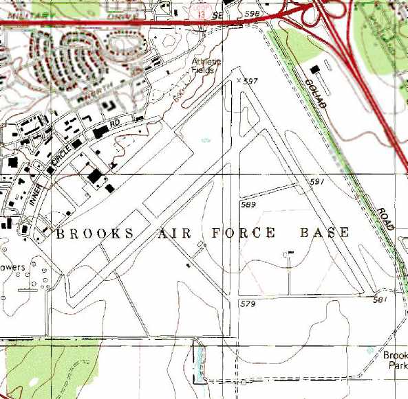
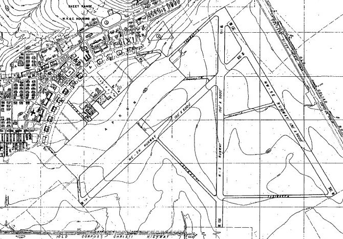
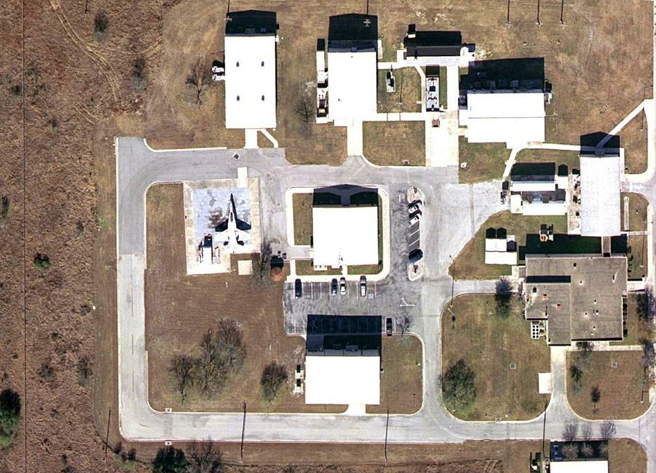
The 1992 USGS topo map depicted the multiple runways, taxiways, ramps, and hangars of Brooks AFB.
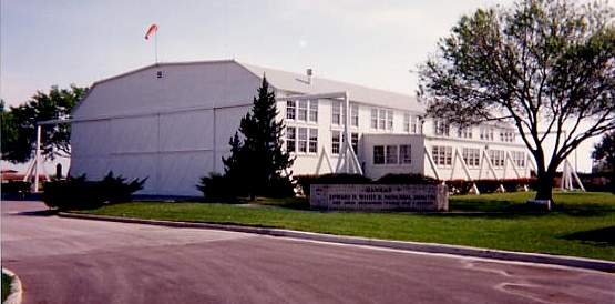
A 1994 photo by Scott Murdock of Hangar 9.
and is a national historic landmark.
It is reputedly the oldest existing former USAAF hangar.

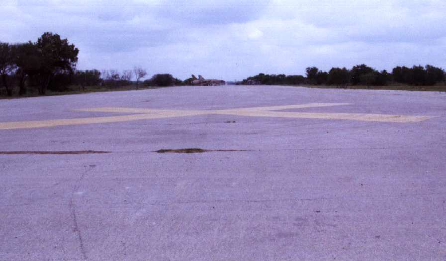
A 1994 photo by Scott Murdock of a closed runway at Brooks AFB.
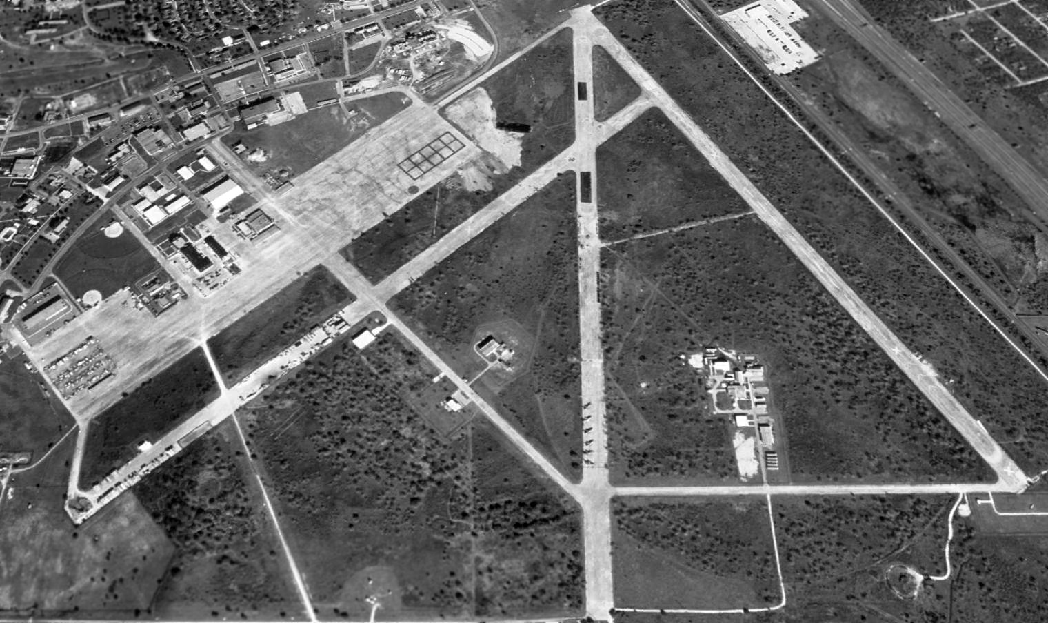
A 1995 USGS aerial view looking north at the abandoned runways of Brooks AFB.
Note at the bottom-center, the 6 F-105 Thunderchief fighters parked on the south end of the abandoned Runway 35.
In 1999, Congress authorized the Secretary of the Air Force to implement a Base Efficiency Project at Brooks AFB.
According to an article in the 4/12/03 issue of the Houston Chronicle (via Steve Cruse),
the Air Force handed over the 1,310-acre installation to the city of San Antonio in 2001,
with the City then leasing back land & facilities to the Air Force for its missions.
It is known under that new arrangement as Brooks City-Base.
Some view the commingling of military and nonmilitary research facilities as the wave of the future
for communities hoping to minimize the negative economic impact of base closures and realignments.
But the cost-conscious Pentagon has sounded an alarm
at the fledgling Brooks Development Authority, the entity that operates the city base.
The Department of Defense wants to consolidate research activities
that are scattered & duplicated among the service branches.
At the same time, Air Force planners want Brooks to dramatically enhance nonmilitary commerce at the base -
or risk losing the prestigious 311th Human Systems Wing & other military entities as the chief tenants.
Unfortunately, the end finally came for the airfield facilities at Brooks AFB in 2004,
as yet another extensive airfield (paid for by the taxpayers) was completely removed,
never to be reused for aviation.
This was described in an article entitled "Runways at Brooks seeing final 'takeoff'"
by Anton Caputo in the 12/24/2004 issue of the San Antonio Express-News (courtesy of John Mechura):
"The ground shakes as a massive excavator methodically scrapes up person-sized pieces of concrete
and dumps them on a growing pile of rubble.
It's an exercise the machine will duplicate countless times over the next 2 months
as crews peel back the three, mile-long runways that have served the former Brooks AFB - now Brooks City-Base - since the 1940s.
Long gone are the military jets and planes that used to roll across this pavement.
Now the runways themselves will follow as the Brooks Development Authority
continues to sell & lease land around the Air Force research facility."
"'All of this will go - as far as the eye can see',
said Brooks Development Authority Environmental Coordinator Greg Hammer,
motioning to a wide expanse of concrete that seems to stretch to the horizon."
"The runway demolition project, which started in early December,
will remove the unneeded concrete to make room for the further development of Brooks City-Base.
The development authority has a master plan for transforming City-Base
into a high-tech research park with a new commercial corner that cuts into the runways.
But the 140,000 tons of concrete & asphalt won't go far.
M&M Contracting has imported a 55-ton crusher to turn the beefy slabs back into usable construction material.
The company is going to stockpile the crushed matter on site for future construction projects.
The most likely use of the pulverized material: as a base for the buildings to make up the 62-acre City Base Landing,
a 570,000-square-foot commercial development that includes a Wal-Mart Supercenter, Office Depot, Chili's, Starbucks and Broadway Bank.
If not, the material probably will be used as the foundation for new roads as the 1,300-acre City-Base is developed."
A 2005 aerial view looking north at the abandoned runways of Brooks AFB, before they were completely removed.
In 2005, it was reported that as part of the 2005 Base Realignment & Closure Commission,
the Air Force was going to divest itself in its remaining share of the Brooks City Base project,
thereby bringing to an end almost a century of military use of Brooks Field.
Scott Beadle reported in 2005, “I have been flying around San Antonio a lot lately.
I take my students to Stinson Field to practice touch & go's.
The pattern there take me right over Brooks.
I can report that the runways have all been torn up.
The main ramp is still intact & is being used as a large parking lot.
There are numerous military activities going on at Brooks including what looks like a field hospital.”
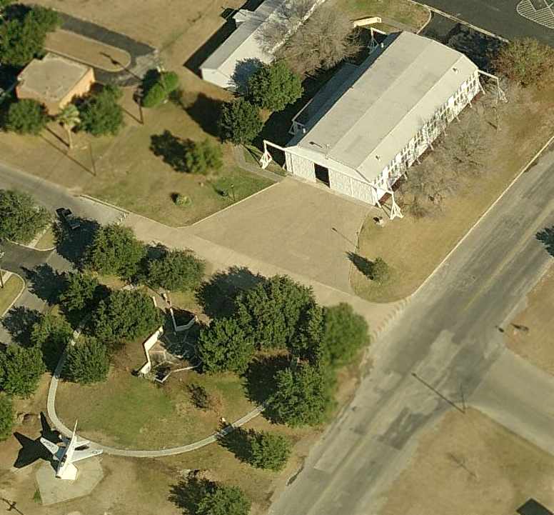
A circa 2006 aerial view looking north at Brooks' Hangar 9,
along with an F-100 Super Saber mounted on a pylon at the bottom of the photo.
A 2006 aerial view of an F/A-18 Hornet parked in a small compound on the southeast side of the Brooks airfield.
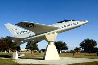
A circa 2000-2009 photo of a F-100F, dubbed “Weightless 2”, mounted on a pylon in front of Brooks' Hangar 9.
The F-100F had been used from 1955-58, by the USAF's School of Aviation Medicine research team
to explore problems associated with weightlessness during flights staged at Edwards & Kelly AFBs.
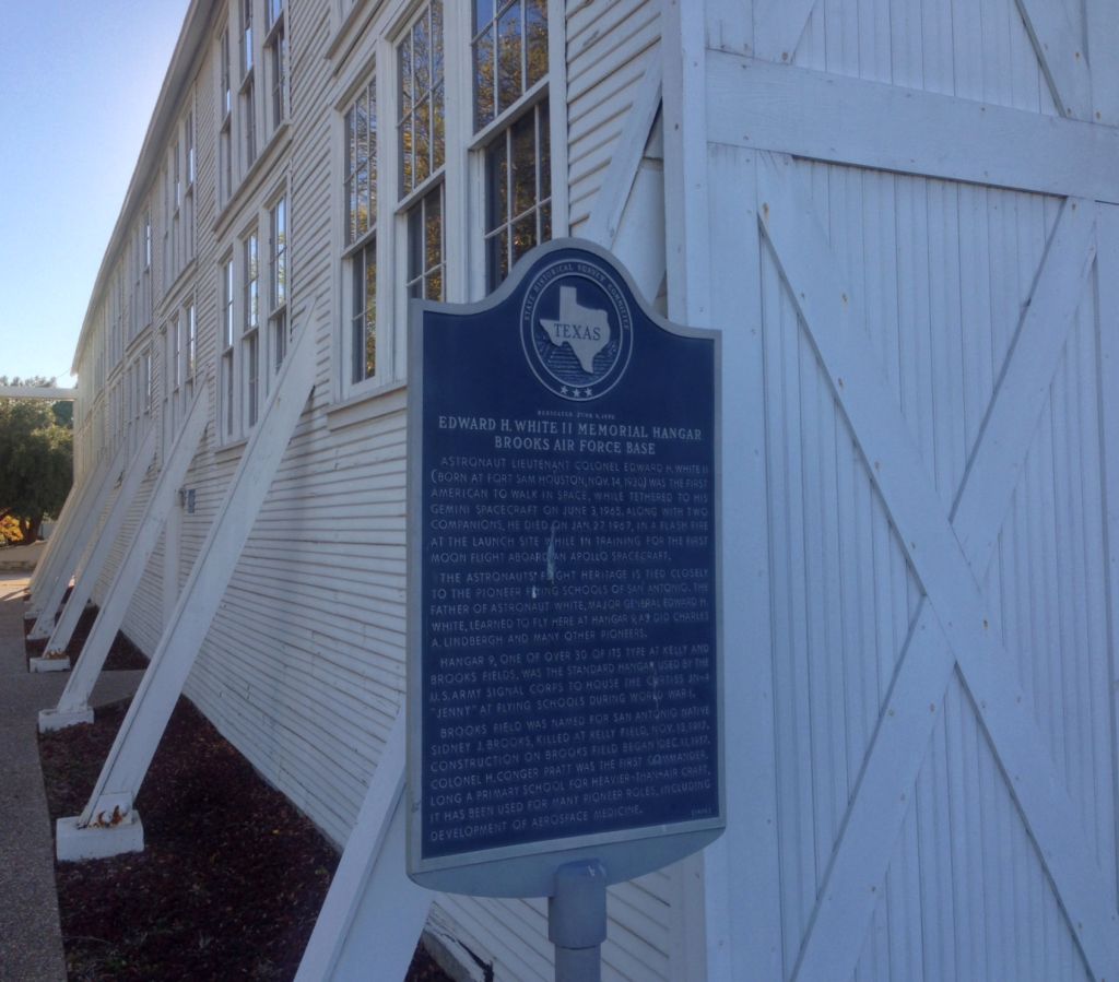
A February 2014 photo by Mark Jenkins (courtesy of Dan MacPherson) of the historic sign in front of Brooks' Hangar 9.
Mark observed, “Sounds like the hangar has been condemned, but is still standing.”
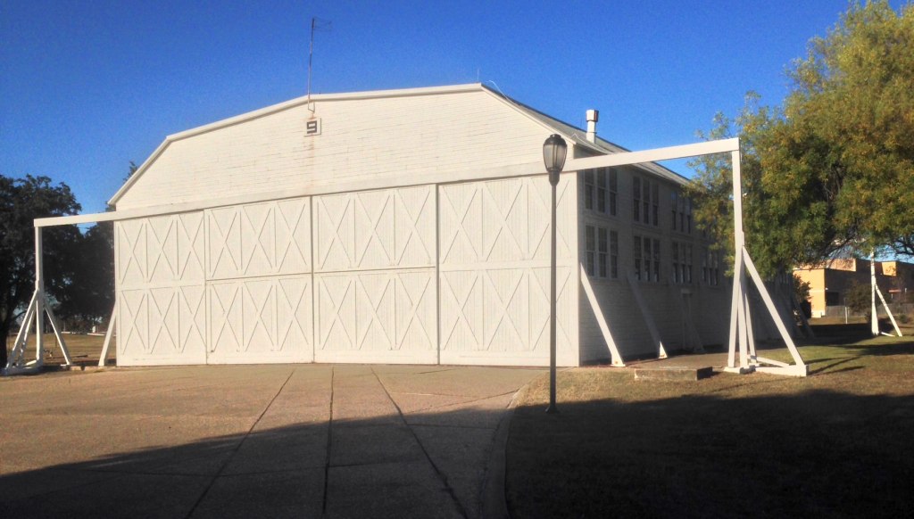
A February 2014 photo by Mark Jenkins (courtesy of Dan MacPherson) of Brooks' historic Hangar 9.
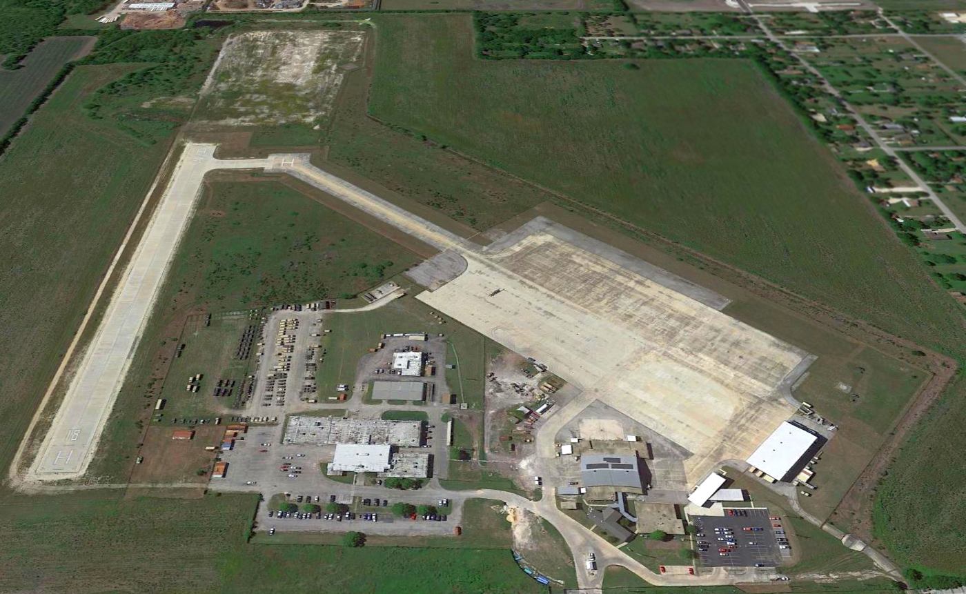
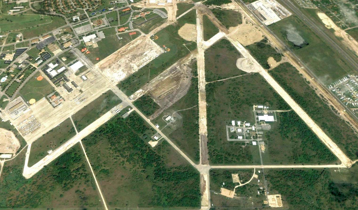
A 2018 aerial view looking north shows the site of the Brooks airfield is almost unrecognizable,
with all the runways having been removed, and only some taxiways & portions of the northwest ramp remaining.
See also:
http://www.brooks.af.mil/history.htm
____________________________________________________
Since this site was first put on the web in 1999, its popularity has grown tremendously.
If the total quantity of material on this site is to continue to grow,
it will require ever-increasing funding to pay its expenses.
Therefore, I request financial contributions from site visitors,
to help defray the increasing costs of the site
and ensure that it continues to be available & to grow.
What would you pay for a good aviation magazine, or a good aviation book?
Please consider a donation of an equivalent amount, at the least.
This site is not supported by commercial advertising –
it is purely supported by donations.
If you enjoy the site, and would like to make a financial contribution,
you
may use a credit card via
![]() :
:
Please consider checking the box to make a monthly donatation.
For a mailing address to send a check, please contact me at: paulandterryfreeman@gmail.com
If you enjoy this web site, please support it with a financial contribution.
please contact me at: paulandterryfreeman@gmail.com
If you enjoy this web site, please support it with a financial contribution.
____________________________________________________
This site covers airfields in all 50 states.