Abandoned & Little-Known Airfields:
Texas, Southern Houston area
© 2002, © 2022 by Paul Freeman. Revised 2/7/22.
This site covers airfields in all 50 states: Click here for the site's main menu.
____________________________________________________
Please consider a financial contribution to support the continued growth & operation of this site.
Camp Hulen AAF (revised 2/7/22) - Cunningham Airport / Erwin-Newman Airport (revised 10/27/21) - Lake Jackson Dow Airport (revised 2/7/22)
Houston Main Street Airport (revised 12/29/19) - Modern Airport / Skyport Airport (revised 10/27/21) - Sam Houston Airport (revised 2/25/19) - Sky Ranch Airport (revised 11/25/19)
____________________________________________________
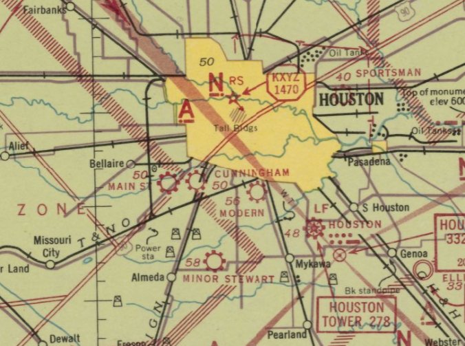
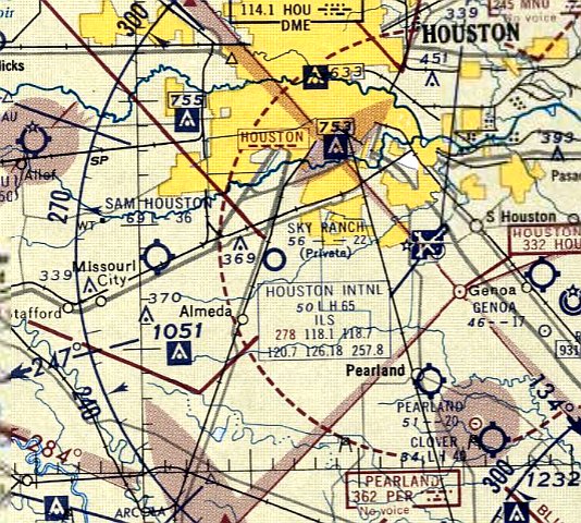
Cunningham Airport / Erwin-Newman Airport, Houston, TX
29.7, -95.39 (Southwest of Downtown Houston, TX)
Cunningham Airport, as depicted on the October 1941 San Antonio Sectional Chart.
This small general aviation airport on the southwest side of Houston was evidently established at some point between 1940-41,
as it was not yet depicted on the March 1940 San Antonio Sectional Chart.
The earliest depiction which has been located of Cunningham Airport was on the October 1941 San Antonio Sectional Chart,
which depicted Cunningham as a commercial/municipal airport.
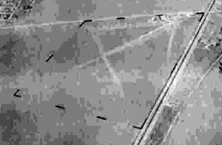
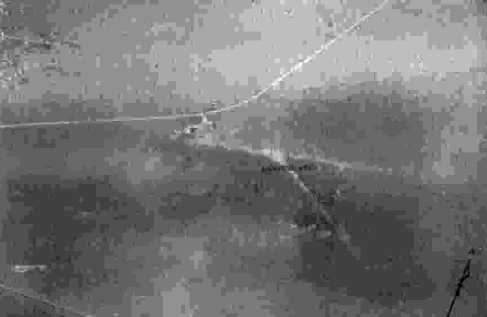
The earliest photo of Cunningham Airport which has been located
was a 10/16/43 aerial view looking north from the 1945 AAF Airfield Directory (courtesy of Scott Murdock).
The (admittedly poor quality) photo depicted “Erwin-Newman Airport (Cunningham Airport)”
as having 2 unpaved runways with a few small buildings on the northeast side.
A 1944 aerial photo (courtesy of Joseph Middleton) depicted Cunningham as having 2 unpaved runways,
with a few small buildings on the northeast side.
There were no aircraft visible on the field, but that may have been due to wartime restrictions on civilian airports near the coasts.
The 1945 AAF Airfield Directory (courtesy of Scott Murdock)
described “Erwin-Newman Airport (Cunningham Airport)” as a 230 acre rectangular property having a 2,000' shell northeast/southwest runway,
with a 3,500' x 2,650' sod all-way landing area under construction.
Erwin-Newman was said to have 3 hangars, with the largest being a 93' x 26' wood structure,
and to be owned & operated by private interests.
The Erwin-Newman Company of Houston was listed in a June 1946 magazine directory
as a dealer of Cessna, Fairchild, and Waco aircraft.
The last aeronautical chart depiction which has been located of Erwin-Newman Airport was on the August 1948 San Antonio Sectional Chart.
It depicted Erwin-Newman Airport as having a 2,800' unpaved runway.
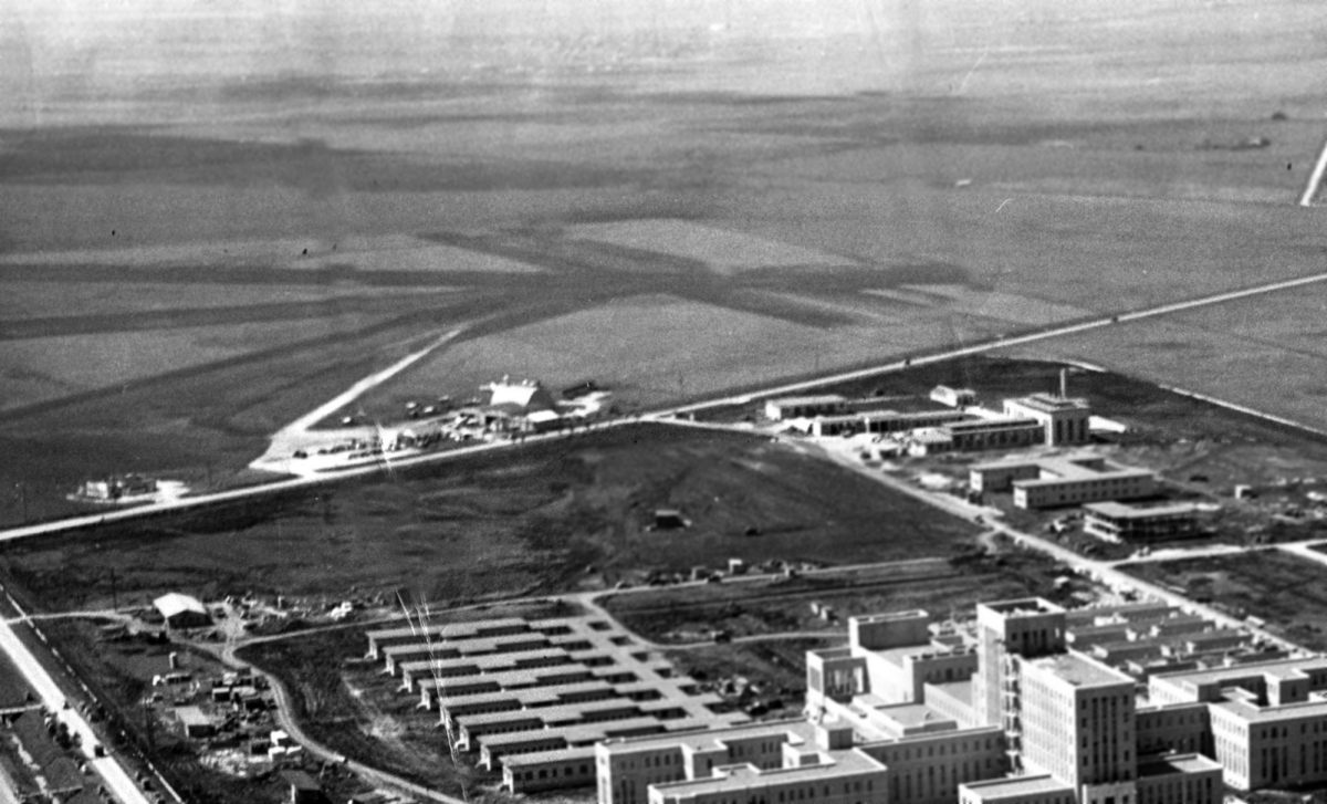
A 1949 aerial view (courtesy of Joseph Middleton) looking southwest showed the Houston Naval Hospital under construction in the foreground,
and the buildings & runways of Erwin-Newman Airport in the background.
Erwin-Newman Airport was evidently closed (for reasons unknown, but presumably due to the rapid development of the local area) at some point between 1945-50,
as it was no longer depicted on the 1950 San Antonio Sectional Chart (courtesy of David Brooks).
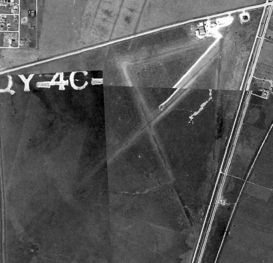
A 1953 aerial photo (courtesy of Joseph Middleton) showed Erwin-Newman's former runways remained recognizable, but a road had been built across the middle of the field.
The airport buildings remained intact on the northeast side.
A 1965 USGS topo map (courtesy of Joseph Middleton) labeled Cunningham as an abandoned airport.
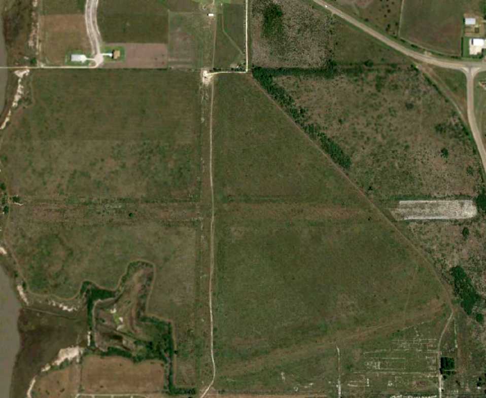
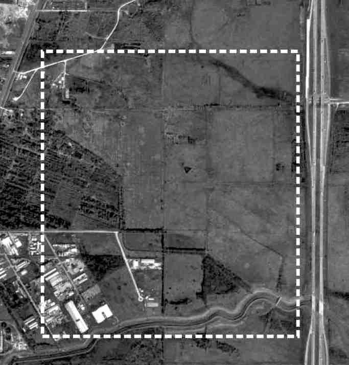
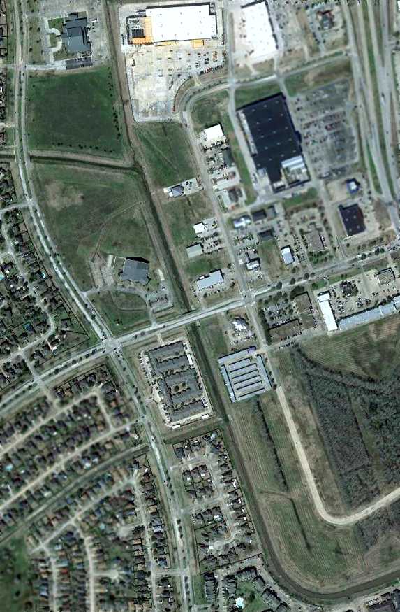
A 2014 aerial view showed the Cunningham Airport site has been densely redeveloped, with no trace remaining of the little airport.
The site of Cunningham Airport is located southwest of the intersection of Old Spanish Trail & Almeda Road.
Thanks to Joseph Middleton for pointing out this airfield.
____________________________________________________
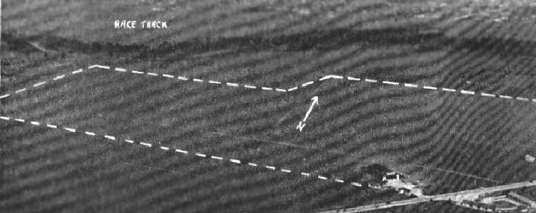
Camp Hulen Army Airfield, Palacios, TX
28.71 North / 96.25 West (Southwest of Houston, TX)
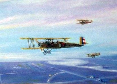
A painting by Lynn Redfern depicting PT-1s overflying Camp Hulen in 1927.
According to the Handbook of TX Online, what was originally known as Camp Palacios
was originally established as a summer training camp for the 36th Infantry Division of the TX National Guard
after the Palacios Campsite Association donated the land to the state in 1926.
The association had in mind the economic benefits a military training center would bring Palacios.
Some 6,500 men came to the first training session in the summer of 1926.
In 1930 the camp was renamed Camp Hulen, after John Augustus Hulen.
By 1934 some 1,886 concrete tent floors had been laid for the trainees.
No airfield in Palacios was listed in The Airport Directory Company's 1933 Airports Directory (according to Chris Kennedy).
The earliest chart depiction of an airfield at Camp Hulen which has been located was on the 1934 San Antonio Sectional Chart.
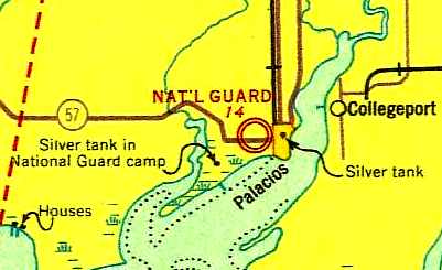
It depicted a military airfield labeled simply "Nat'l Guard", located adjacent to then the western edge of the town of Palacios.
The 1934 Department of Commerce Airfield Directory (courtesy of Chris Kennedy)
described the "36th Division TX National Guard Air Corps Field"
as being located "2 miles west of city on Hug-the-Coast Highway".
It was described as a 2,400' square sand field, with "no servicing facilities."
The Airport Directory Company's 1937 Airports Directory (courtesy of Bob Rambo)
listed a "National Guard" auxiliary airfield in Palacios, "2 miles west of city on highway."
It was described as a 2,400' square sand field, with "no service."
According to the Handbook of TX Online, in 1940 the War Department began to use Camp Hulen
for antiaircraft training for National Guard units from across the country,
as the surrounding bays provided a safe range for target practice.
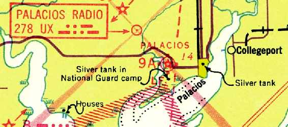
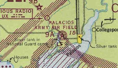
The Palacios Airfield was depicted as the CAA Intermediate Field Site "9A"
on the October 1941 San Antonio Sectional Chart (courtesy of David Brooks).
Thus it appears the field had joint civilian & military usage, at least for some period of time.
A September 1942 storm did extensive damage to Camp Hulen.
This may have been the reason for this airfield to be abandoned,
and construction began on a replacement airfield in October 1942, just across Route 57 to the north.
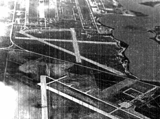
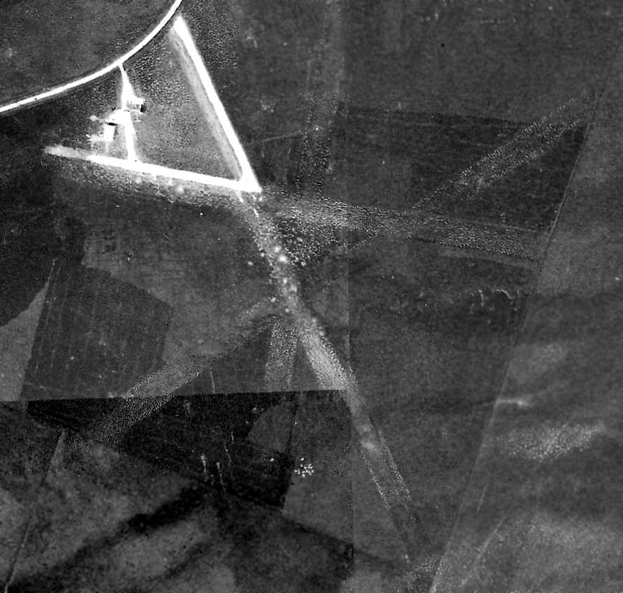
The only photo which has been located showing the original Camp Hullen airfield in operation was a 3/5/43 aerial view.
It depicted the field as having 3 paved runways, with a dozen aircraft visible on a paved ramp on the southeast side.
There did not appear to be any hangars on the field.
The June 1943 San Antonio Sectional Chart (courtesy of Chris Kennedy)
still depicted the original Camp Hulen Airfield, labeled as "Palacios Army Air Field",
and also indicated that it was Department of Commerce Site 9A.
The original Camp Hulen Airfield was replaced by a new Palacios Army Airfield
on the north side of the highway “in mid-1943”, according to Ron Plante.
“Camp Hulen's short, unpaved runways were adequate for occasional pre-war Texas National Guard use,
but were totally unsuitable for sustained tow target operations
after the Camp was established as a Regular Army anti-aircraft artillery training center in 1941.
Poor drainage, a 3,500' max runway length, and no room to expand
led the Army Air Forces to build a brand-new field just north of Highway 35.
In July of 1943, Palacios AAF took over the tow target mission
with its three 5,000' concrete runways, a ramp, taxiways, and 13 hardstands.”
A 1944 aerial view (courtesy of Ron Plante) looking south at the original Camp Hullen airfield,
as well as the replacement Palacios AAF in the foreground.
By the time of the July 1945 San Antonio Sectional Chart (courtesy of Chris Kennedy),
the original Camp Hulen airfield was no longer depicted at all (only the new Palacios AAF was depicted).
According to Ron Plante, “The Camp Hulen strip may still have been used by liaison aircraft,
but when the post closed in 1946, that was the end of the airstrip.”
On 5/31/46, the War Department declared Camp Hulen surplus & returned it to the TX National Guard.
Rather than use it for summer training, the guard slowly dismantled it for scrap.
The original Camp Hulen Airfield was apparently never used again,
as it did not appear on later aeronautical charts or USGS topo maps.
In 1965 the Camp Hullen property was sold to developers hoping to construct an industrial park.
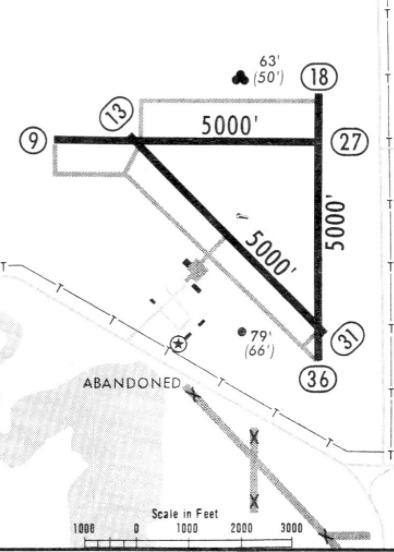
A 1968 approach plate for Palacios Airport (courtesy of Jonathan Westerling) still depicted the runways of the former Camp Hullen airfield,
more than 20 years after the Camp Hullen airfield's abandonment.
However, by 1985 the abandoned Camp Hullen still remained undeveloped.
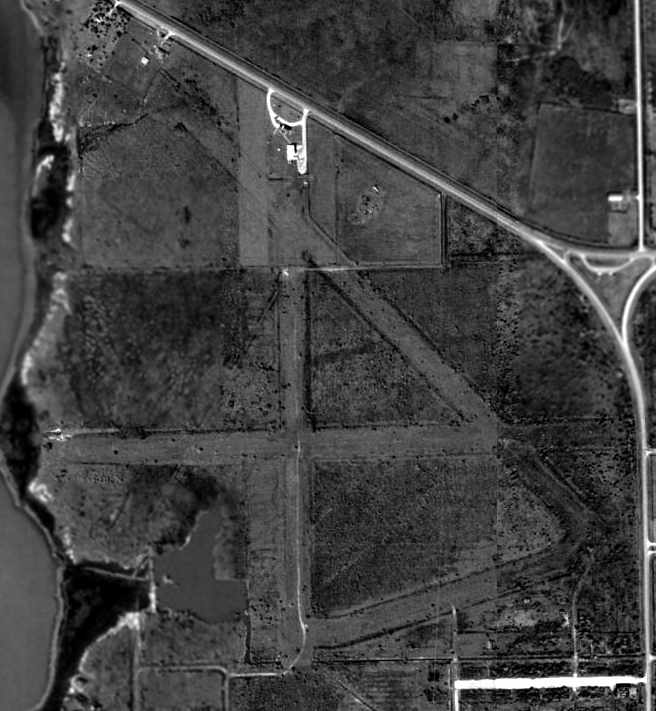
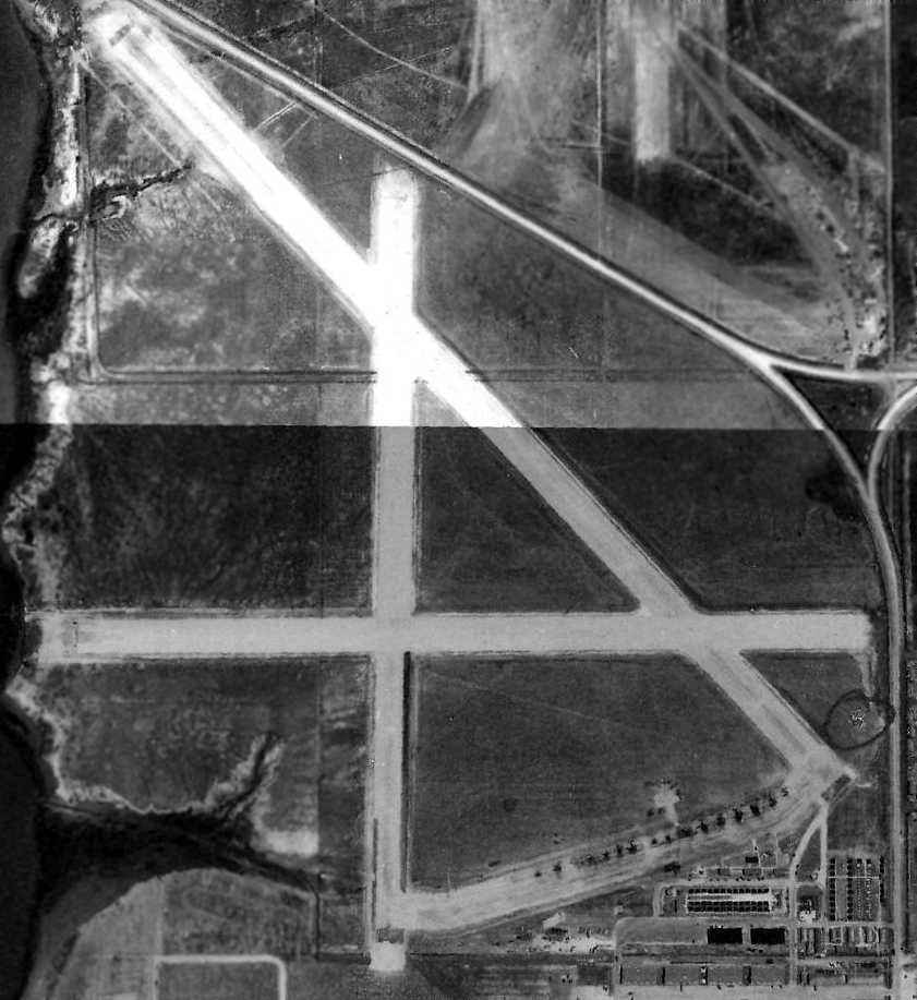
As seen in the 1995 USGS aerial photo, the outline of 3 former runway at the site of Camp Hulen Army Airfield were still quite obvious.
The longest runway was the 3,700' northwest/southeast strip.
Although there were several minor buildings around the periphery of the airfield site,
it did not appear as if any of them were originally related to the airfield.
Ron Plante reported, “In September of 2006, the Camp Hulen cantonment area was being developed into housing,
but as near as I could tell the old airstrip was not affected.”
In a 3/31/08 aerial photo of the site of Camp Hulen Army Airfield, the outline of the 3 former runways were still recognizable.
A 10/23/13 aerial view by Lynn Redfern looking west at the remains of Camp Hulen Army Airfield,
showing the outline of the 3 former runways as still recognizable.
The site of the Camp Hulen Army Airfield is located west of the intersection of Route 35 & State Route Loop 141,
adjacent to the south side of Palacios Municipal Airport.
Thanks to David Brooks for locating this airfield.
____________________________________________________
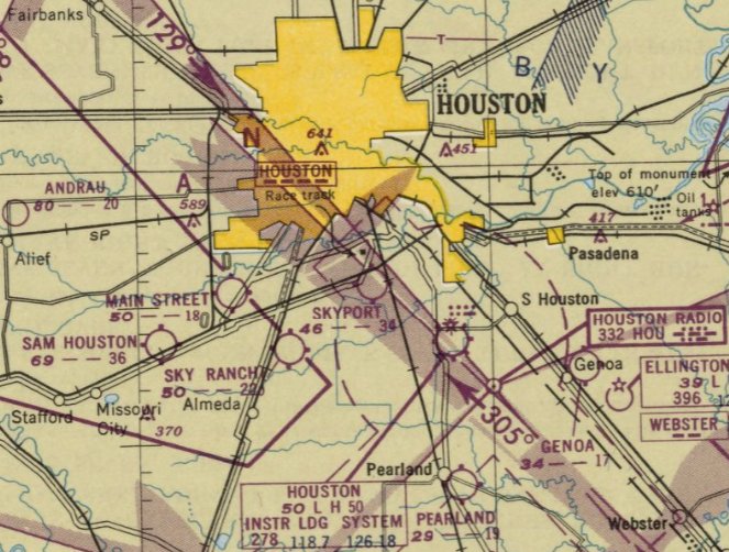
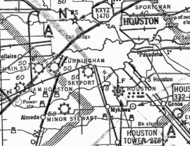
Modern Airport / Skyport Airport, Houston, TX
29.68, -95.34 (Southwest of Downtown Houston, TX)
Modern Airport, as depicted on the October 1941 San Antonio Sectional Chart.
This particularly short-lived airport was apparently established at some point between 1937-43,
as it was not listed in The Airport Directory Company's 1937 Airports Directory (courtesy of Bob Rambo).
nor depicted on the March 1940 San Antonio Sectional Chart.
The earliest depiction which has been located of Modern Airport was on the October 1941 San Antonio Sectional Chart,
which depicted Modern as a commercial/municipal airport.
Modern Airport was evidently renamed Skyport Airport after less than a year,
as that is how it was depicted on the April 1942 San Antonio Sectional Chart (courtesy of Ron Plante).
It depicted Skyport as a commercial/municipal airport.
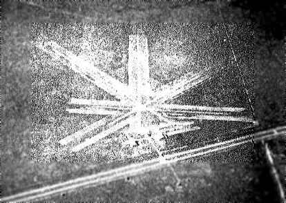
The earliest photo of Skyport Airport which has been located
was a 10/16/43 aerial view looking north from the 1945 AAF Airfield Directory (courtesy of Scott Murdock).
The (admittedly poor contrast) photo depicted Skyport as possibly having 2 runways.
The 1944 US Army/Navy Directory of Airfields (courtesy of Ken Mercer) described Skyport as having a 3,500' unpaved runway.
The last photo of Skyport Airport which has been located was a 1944 aerial view.
It depicted Skyport as having 4 unpaved runways, with what appeared to be short paved sections on the northwest portion of 2 runways.
Two small hangars & at least one small plane were visible on the northwest side of the field.
The 1945 AAF Airfield Directory (courtesy of Scott Murdock) described Skyport Airport
as a 166 acre irregularly-shaped property having 4 shell & sod runways, the longest being a 3,225' northeast/southwest strip.
The field was said to have a single 80' x 50' wood & metal hangar,
and to be owned & operated by private interests.
The January 1950 San Antonio Sectional Chart (courtesy of David Brooks)
described Skyport as a commercial airport having a total of 3 unpaved runways, with the longest being 3,350'.
David Brooks recalled, "My Uncle would go out to airfields to watch the planes & I liked to tag along.
Even though he would normally drive to the main Houston Municipal Airport (now Hobby),
there were 2 in the general area that we would stop at from time to time.
I can not say for sure I remember this field, but it is in the area that would be on the path he would drive.
He lived on Wheeler street across from the University of Houston
and we would normally drive in a southerly direction.
I recollect (vaguely) this field as it was on the road to Hobby.
It was relatively small & had a few light aircraft around some small buildings."
Sky Port Airport was still depicted on the 1950 USGS topo map, along with several other small general aviation airports.
Skyport Airport was apparently closed (for reasons unknown) at some point in 1950,
as it was no longer depicted on the August 1950 San Antonio Sectional Chart
or the 1952 Humble Oil Houston street map.
A 1953 aerial view showed that the Skyport Airport site had become redeveloped with dense housing.
As seen in a 3/11/11 aerial photo, the site of Skyport Airport has been heavily redeveloped,
and not a trace appears to remain of the former airport.
The site of Skyport Airport is located at the intersection of Interstate 610 & Mykawa Road.
____________________________________________________
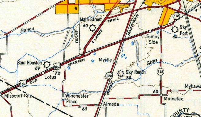
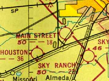
Sky Ranch Airport, Houston, TX
29.64, -95.4 (Southwest of Downtown Houston, TX)
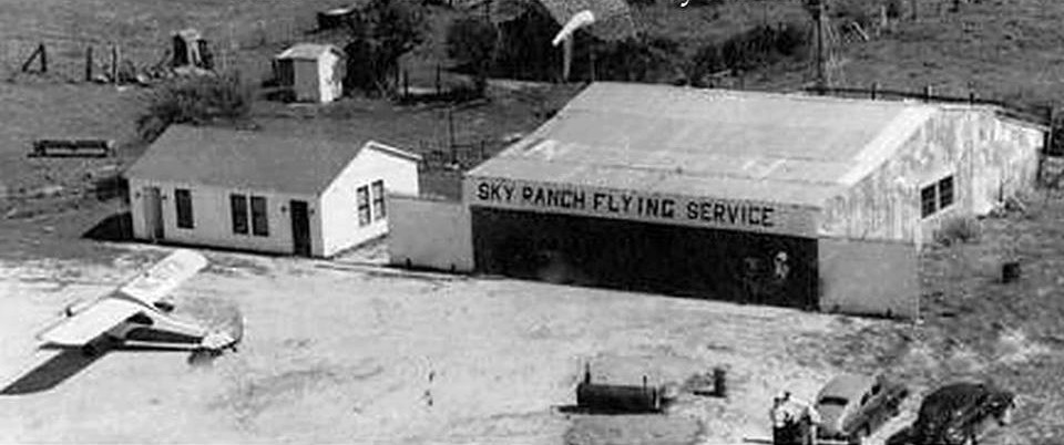
A circa 1945-48 aerial view of showing a single-engine aircraft, office, and hangar at Sky Ranch Airport (courtesy of Ed Lewis).
No airfield was yet depicted at this location on a 1944 aerial photo,
and Sky Ranch was not yet listed among active airfields in the 1944 US Army/Navy Directory of Airfields (courtesy of Ken Mercer)
or the 1945 AAF Airfield Directory (courtesy of Scott Murdock).
Following WW2, three Tuskegee Airmen, Ben Stevenson, Elton “Ray” Thomas & Hulon “Pappy” White
relocated to Houston Texas to establish a flight training program, charter flying, cargo services
as well as other services that would afford black G.I.’s & civilians the opportunity to learn about aviation,
continuing the tradition of the Tuskegee Airmen.
Located on Reed road, on the historic Taylor-Stevenson Ranch, The Sky Ranch started operations in 1946.
Azellia White (wife of “Pappy” White) made her mark in history
by becoming the first black female pilot licensed in the state of Texas in 1946.
Sky Ranch served as an airport for the segregated black community & provided instruction to veterans interested in flying.
The only photo which has been located of Sky Ranch Airport was a circa 1945-48 aerial view (courtesy of Ed Lewis)
showing a single-engine aircraft, office, and hangar marked “Sky Ranch Flying Service” .
Sky Ranch was not yet depicted on the July 1947 San Antonio Sectional Chart.
The earliest aeronautical chart depiction which has been located of Sky Ranch Airport was on the August 1948 San Antonio Sectional Chart.
It depicted Sky Ranch as having a 2,200' unpaved runway.
Sky Ranch reportedly ceased operations in 1948, lasting a mere 2 years,
after legislation restricted the use of the G.I. Bill, causing a downturn in flight training business.
The January 1950 San Antonio Sectional Chart (courtesy of David Brooks) described Sky Ranch as a commercial airport
having a total of 3 unpaved runways, with the longest being 2,200'.
Sky Ranch Airport was still depicted on the 1950 USGS topo map, along with several other small general aviation airports.
Sky Ranch was evidently closed by 1952,
as it was no longer depicted at all on a 1952 Humble Oil street map of Houston,
or a 1953 aerial photo.
The last aeronautical chart depiction which has been located of Sky Ranch was on the March 1956 San Antonio Sectional Chart.
It depicted Sky Ranch as a private airfield having a 2,200' unpaved runway.
Sky Ranch was no longer depicted on the August 1956 San Antonio Sectional Chart.
A 1978 aerial photo did not depict any aviation use of the Sky Ranch site, but the area of the former airfield remained clear.
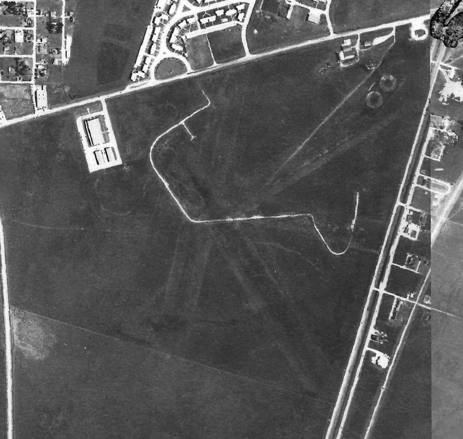
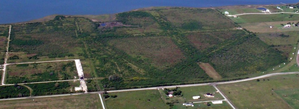
The outline of the Sky Ranch Airport property has been superimposed by David Brooks over the 1995 USGS aerial photo.
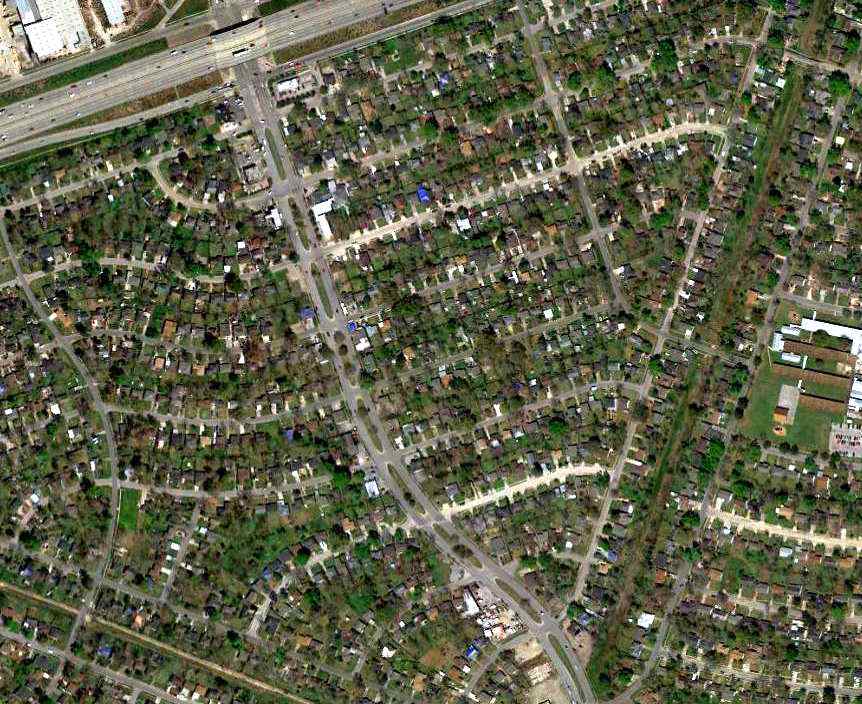
Unlike many other former Houston-area airfields, the site has not been redeveloped,
and remained largely an open grass field.
Most remarkably, the layout of the former runways appears to still be recognizable.
The site of Sky Ranch Airport is located northwest of the intersection of Route 288 & Amelda Genca Road.
____________________________________________________
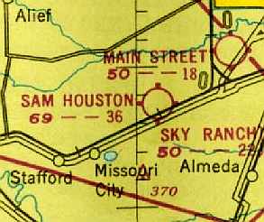
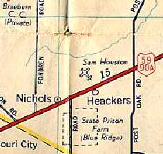
Sam Houston Airport, Houston, TX
29.64, -95.49 (Southwest of Downtown Houston, TX)
Sam Houston Airport, as depicted on the April 1942 San Antonio Sectional Chart (courtesy of Ron Plante).
This small general aviation airport was apparently established at some point between 1941-43,
as it was not listed in The Airport Directory Company's 1937 Airports Directory (courtesy of Bob Rambo)
nor depicted on the October 1941 San Antonio Sectional Chart.
The earliest depiction of Sam Houston Airport which has been located
was on the April 1942 San Antonio Sectional Chart (courtesy of Ron Plante),
which depicted Sam Houston as a commercial/municipal airport.
The earliest photo which has been located of Sam Houston Airport was a 1943 aerial view looking north
from the 1945 Army Air Forces Airport Directory (courtesy of Chris Kennedy).
It depicted the field as having 4 runways.
The 1944 US Army/Navy Directory of Airfields (courtesy of Ken Mercer)
described Sam Houston as having a 3,200' unpaved runway.
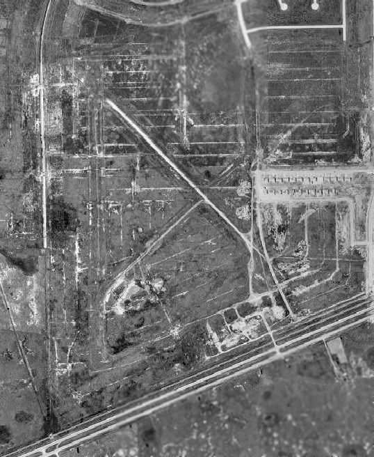
A 1944 aerial view looking north depicted Sam Houston as having 4 runways, with 2 hangars & a dozen light aircraft on the south side.
The 1945 AAF Airfield Directory (courtesy of Scott Murdock) described Sam Houston Airport
as a 640 acre irregularly-shaped property having 5 shell runways, the longest being a 3,000' northeast/southwest strip.
The field was said to have 4 hangars, the largest being a 110' x 107' wood & metal structure.
Sam Houston Airport was described as being owned & operated by private interests.
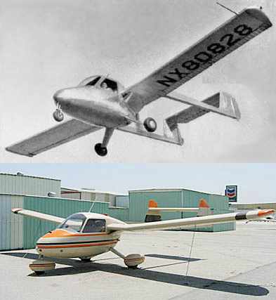
Two undated photos of the Anderson-Greenwood AG-14, built at the Sam Houston Airport.
Sam Houston Airport was (briefly) the site of an aircraft manufacturer.
After the end of the Second World War, former Boeing employee Ben Anderson & his brother-in-law Marvin Greenwood
established a company at Sam Houston Airport to develop an aircraft
to satisfy the perceived post-war demand for general aviation aircraft.
Their AG-14 first flew on 10/1/47. It was an unusual design, having a twin-boom tail & a pusher propeller.
Five AG-14s were built, but unfortunately the program was not an economic success.
[As of 2004, at least one AG-14 survives, as well as possibly a second example.]
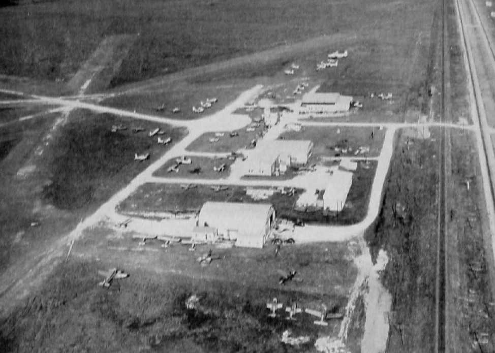
A 1947 aerial view looking northeast depicted Sam Houston Airport as a popular field,
with dozens of light aircraft parked around a collection of hangars on the south side of several unpaved runways.
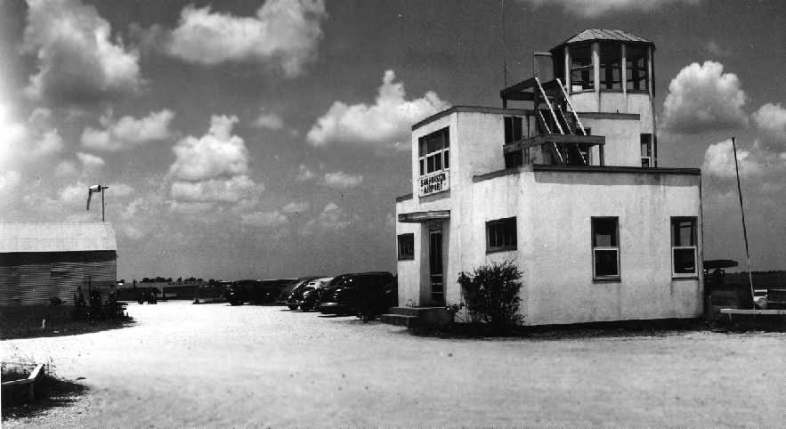
A circa 1949-51 picture (courtesy of Gordon Cragg) of the Sam Houston Airport office building, with a small tower.
Gordon recalled, “My Dad flew out of there in the late 1940s & early 1950s.”
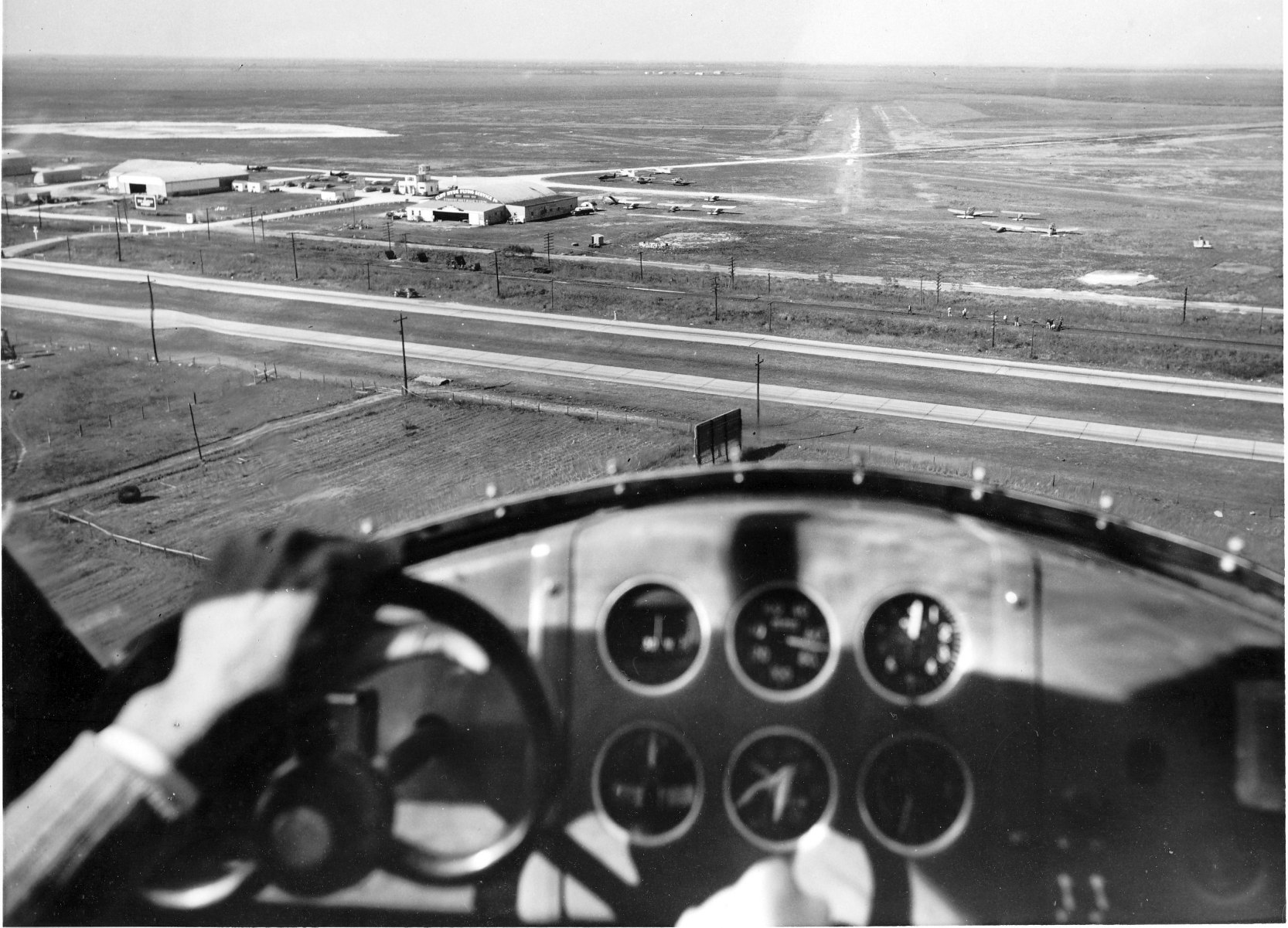
An undated aerial view by Joseph Demic (courtesy of Doug Bickford, from a December 1950 magazine article) showing Ed Hoadley landing an Anderson Greenwood AG-14 on approach to the northwest at Sam Houston Airport.
The January 1950 San Antonio Sectional Chart (courtesy of David Brooks) described Sam Houston as having a total of 5 runways, with the longest being 3,600'.
Sam Houston Airport was still depicted on the 1950 USGS topo map, along with several other small general aviation airports.
Sam Houston Airport, as depicted on a 1952 Humble Oil street map of Houston.
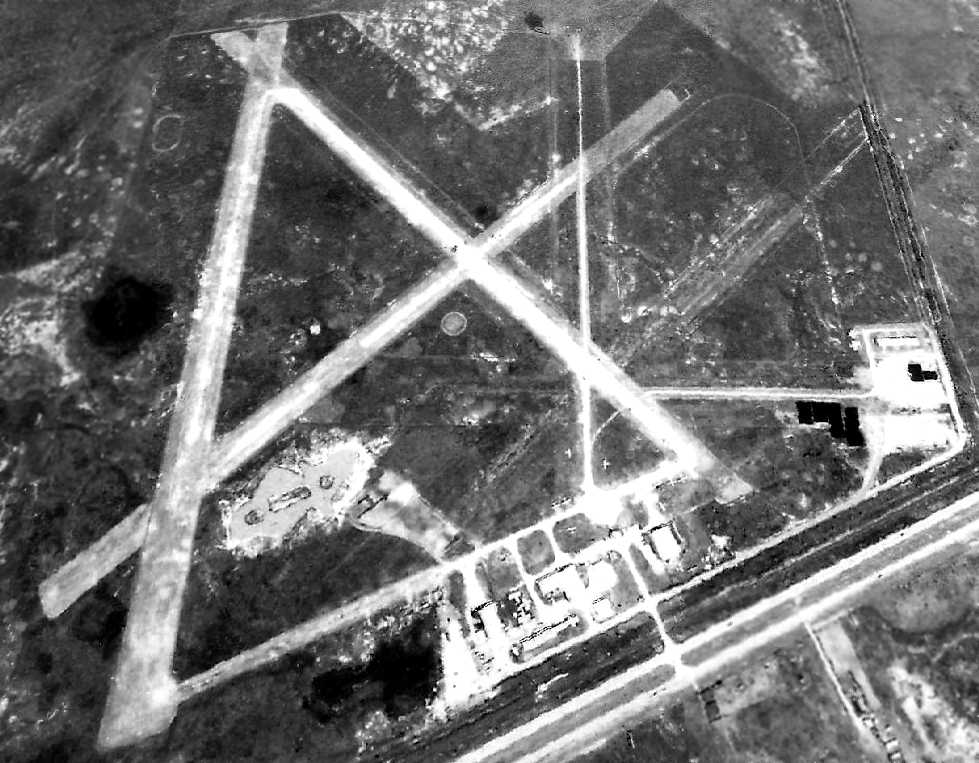
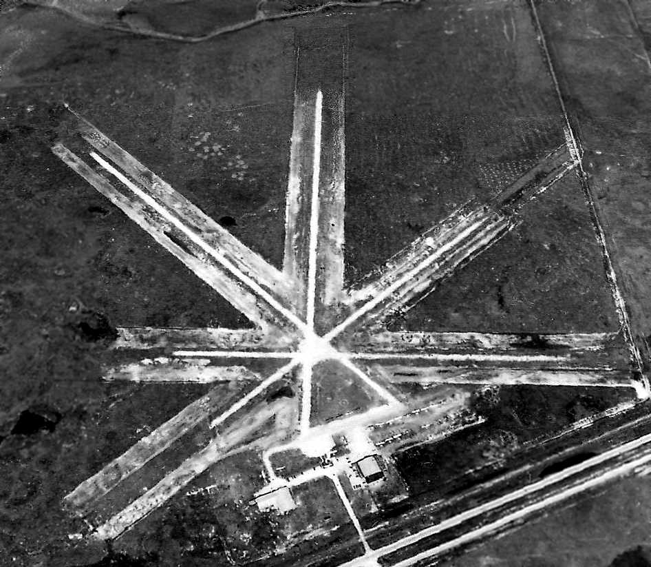
A 1953 aerial view looking north showed that Sam Houston Airport's original configuration of 4 unpaved runways was replaced at some point between 1947-53
by a significantly larger set of 3 runways, somewhat to the west of the original layout.
The cluster of hangars had grown as well, and there were a dozen light aircraft visible.
Sam Houston Airport was still depicted as an active airport on a 1955 Humble Oil street map of Houston.
Sam Houston Airport was apparently closed (for reasons unknown) at some point between 1953-56,
as it was no longer depicted on the 1956 USGS topo map.
A 1958 aerial view of the site of Sam Houston Airport showed the remains of at least 3 runways, but all of the hangars had been removed,
and construction had begun on the housing development which would eventually cover the site.
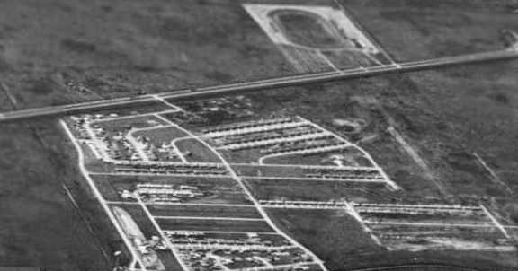
A circa 1960 aerial view looking southwest at the Sam Houston Airport site (courtesy of Mark Keith)
showed that the majority of the airport property had already been built upon by residential housing.
However, the remains of the former north/south runway were still recognizable (on the right side of the photo).
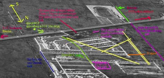
A version of the circa 1960 aerial view annotated by Mark Keith to show the presumed alignment of the Sam Houston Airport runways.
Sam Houston Airport was no longer depicted at all on a 1961 Humble Oil street map of Houston,
or depicted at all on the 1964 San Antonio Sectional Chart (courtesy of John Voss).
A 1978 aerial photo showed that the site of Sam Houston Airport had been thoroughly covered by housing,
and not a trace appeared to remain of the former airport.
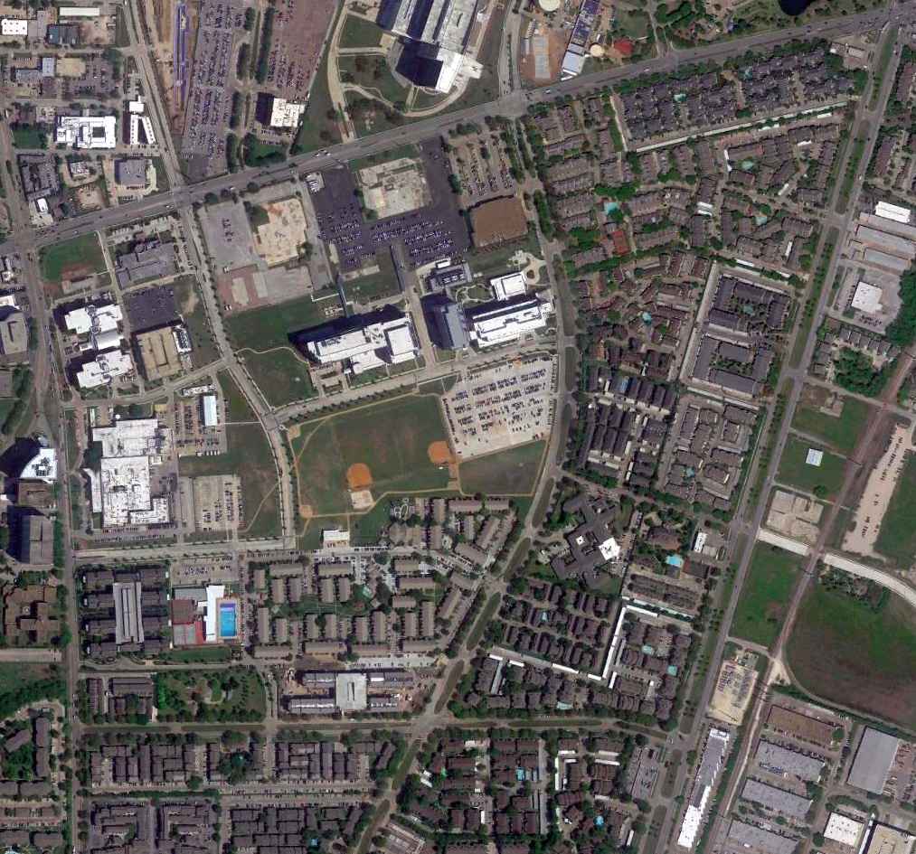
A 2002 USGS aerial view showed the site of Sam Houston Airport to be heavily redeveloped, and not a trace appears to remain of the former airport.
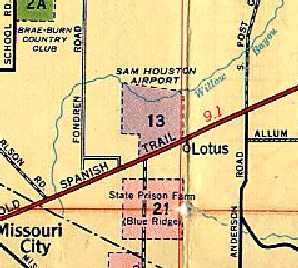
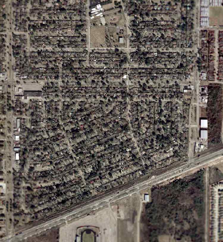
The site of Sam Houston Airport is located northwest of the intersection of Main Street & Chimney Rock Road.
____________________________________________________
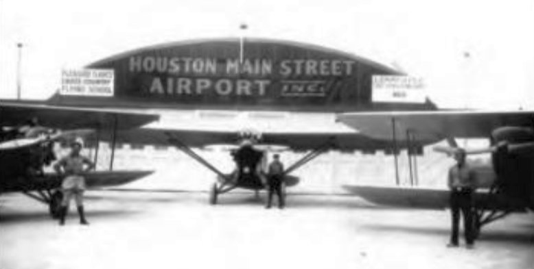
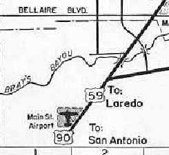
Main Street Airport, Houston, TX
29.69, -95.42 (Southwest of Downtown Houston, TX)
Main Street Airport, as depicted on the February 1934 San Antonio Sectional Chart.
Photo of the airfield while open has not been located.
Houston's Main Street Airport apparently dated back to before 1934,
as "Main St" was depicted as a commercial or municipal airport on the February 1934 San Antonio Sectional Chart.
The earliest photo which has been located of Main Street Airport was a circa 1930s photo of 2 biplanes & a monoplane in front of the hangar.
An aerial view looking north at Houston Main Street Airport,
from The Airport Directory Company's 1937 Airports Directory (courtesy of Bob Rambo).
The directory described Main Street Airport as having 2 sod runways, with the longest being the 1,600' east/west strip.
The aerial photo in the directory depicted a single hangar at the southeast corner of the field,
which was said to have "Houston Main Street" painted on the roof.
Main Street Airport was depicted on a 1940 Houston street map
as an irregularly-shaped property bounded by Route 59 on the southeast side.
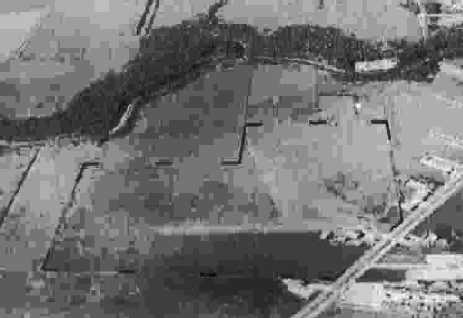
A 10/16/43 aerial view looking north from the 1945 AAF Airfield Directory (courtesy of Scott Murdock)
depicted Houston Main Street as having an L-shaped outline, with several buildings along the southeast corner.
The last date photo which has been located of Houston Main Street Airport was a 1944 aerial view looking north.
It depicted the field as having 2 unpaved runways, with several small buildings on the southeast side.
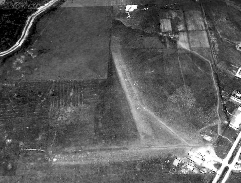
The 1945 AAF Airfield Directory (courtesy of Scott Murdock) described Houston Main Street Airport
as a 108 acre L-shaped property having 3 sod runways, the longest being a 2,200' east/west strip.
The field was said to have 3 hangars, the largest being a 100' x 60' wood & metal structure.
Houston Main Street Airport was described as being owned & operated by private interests.
According to Micheal McMurtrey, a Cessna T-50 was registered to Nierth Aero Services at Main Street Airport.
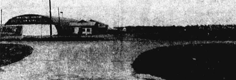
An undated photo of Main Street Airport's hangar, from a 1/29/46 newspaper article (courtesy of Mabry Tyson).
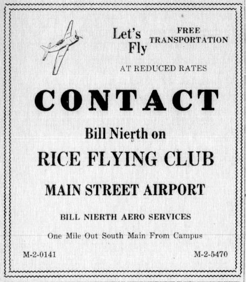
An advertisement for Main Street Airport's Rice Flying Club, from the Rice University newspaper The Thresher 5/30/46 (courtesy of Micheal McMurtrey).
Main Street Airport was described in the Aerodromes table
on the January 1950 San Antonio Sectional Chart (courtesy of David Brooks)
as having 2 runways, with the longest being an 1,800' turf strip.
Main Street Airport was still depicted on the 1950 USGS topo map, along with several other small general aviation airports.
Main Street Airport was evidently closed at some point between 1950-51,
as it was no longer depicted on the August 1951 San Antonio Sectional Chart.
A 1953 aerial photo showed that the site of Main Street Airport had been thoroughly covered by housing,
and not a trace appeared to remain of the former airport.
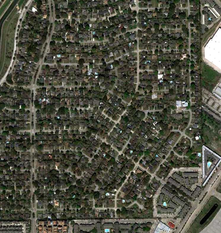
A 3/11/11 aerial photo shows that the Main Street Airport site has been heavily redeveloped, and not a trace appears to remain of the former airport.
The site of Main Street Airport is located north of the intersection of Interstate 610 & Main Street, less than a mile west of the Astrodome.
____________________________________________________
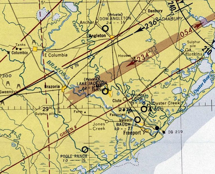
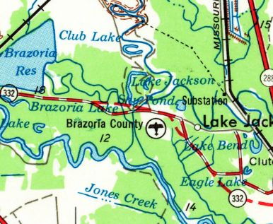
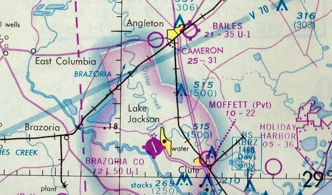
Brazoria County Airport / Lake Jackson Dow Airport, Lake Jackson, TX
29.04, -95.46 (South of Houston, TX)
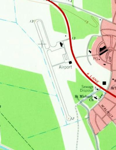
The Lake Jackson Airport, as depicted on the August 1955 San Antonio Sectional Chart.
No airfield was yet depicted at this location on a 1952 aerial photo (courtesy of Adam DeLand).
Lake Jackson Airport was built by the Dow Company.
Lake Jackson Airport was not yet depicted on the February 1955 San Antonio Sectional Chart.
The earliest depiction which has been located of Lake Jackson Airport was on the August 1955 San Antonio Sectional Chart.
It depicted Lake Jackson as a private airfield having a 5,000' paved runway.
According to “Episodes: TX Dow 1940-76” by Bill Colegrove (courtesy of Phil Beutel),
“The new Dow Airport in Lake Jackson was completed on 1/5/56. The Dow Cessna airplane landed there that afternoon.
The first passenger flight was on January 6, with Dow TX Division General Manager Dr. A.P. Beutel as passenger.”
Phil Beutel recalled, “This airport was started by my Dad when he was the General Manager of the TX Division of Dow.
He had Dow's first private plane, so he could get from Freeport - Lake Jackson to Midland, MI without a lot of wasted time.”
The earliest photo which has been located of the Lake Jackson Down Airport was a 1956 aerial view (courtesy of the City of Lake Jackson, via James Pierce) looking southwest.
It showed the newly-built field having a single paved northwest/southeast runway, with a taxiway leading to a ramp on the northeast side.
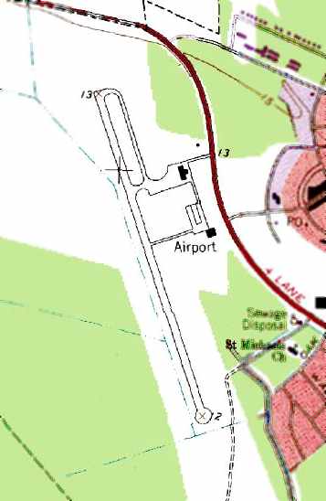
The 1956 USGS topo map depicted Brazoria County Airport.
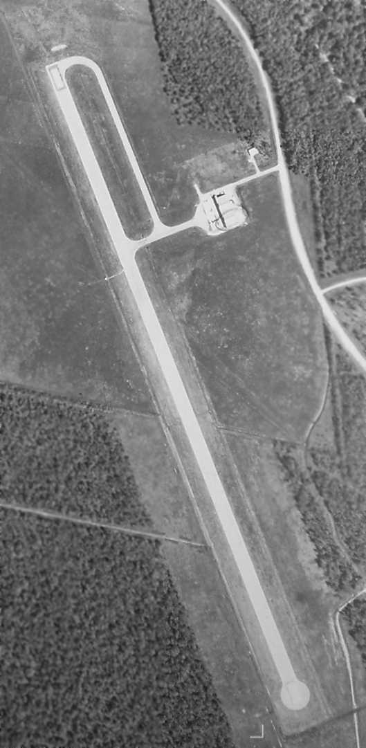
A 1958 aerial photo (courtesy of Adam DeLand) depicted Lake Jackson Down Airport as having a single paved northwest/southeast runway,
with a partial-length parallel taxiway leading to a small ramp with a single hangar on the northeast side.
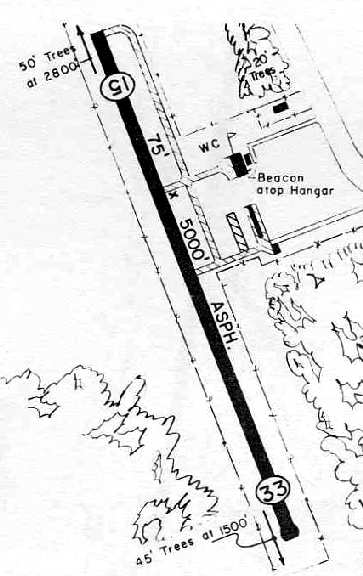
The 1962 AOPA Airport Directory described Lake Jackson Dow Airport as having a single 5,500' macadam Runway 15/33.
It also includes the note, "Caution: Emergency use only."
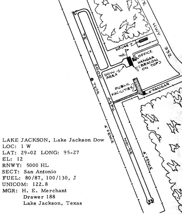
The 1963 TX Airport Directory depicted 2 hangars east of the runway,
one labeled "Dow area" & the other "public facilities" (which had evidently been added at some point between 1958-63).
The manager was listed as H.E. Merchant.
The 1963 USGS topo map depicted a single northwest/southeast runway, labeled simply as “Airport”.
The Aerodromes table on the 1964 San Antonio Sectional Chart (courtesy of Bill Suffa)
described Lake Jackson Airport as having a single 5,000' asphalt runway.
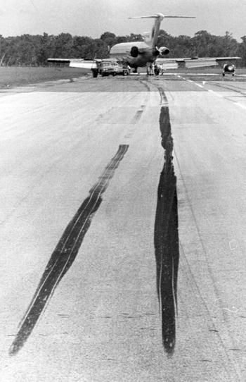
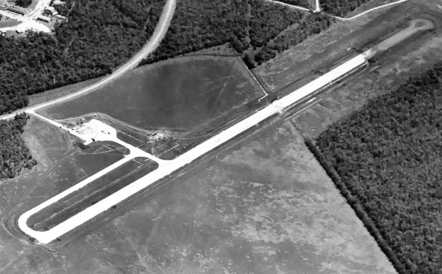
A July 1972 photo of the prominent skid marks on the Lake Jackson Airport runway caused by the braking of the hijacked National Airlines 727.
According to Richard Huntington, "The Lake Jackson Airport has also a bit of publicity most people don't remember.
A plane [a National Airlines 727-200] was hijacked & landed there.
The event was covered by Jessica Savitch, then a reporter for a Houston TV station. It happened in [July 12] 1972."
“We were up there over the Gulf with almost no fuel.
We thought about trying to put it down on the beach but then we noticed Lake Jackson,” flight engineer Gerald Beaver told the Houston Post days after the hijacking.
Boeing 727s aren’t really supposed to land on 5,000' runways.
But as the jet touched down, the crew hit the brakes, causing the plane to swerve & throwing the hijackers off balance.
In the process, two tires blew out.
As the aircraft came to a stop, co-pilot Norman Reagan & Beaver jumped out.
Beaver was able to flee into some nearby woods, but Reagan was severely injured when he hit the ground.
Federal & local authorities quickly surrounded the plane & started negotiations.
After a few hours, one of the flight attendants was released.
Eventually the hijackers said they would surrender only to the FBI & not to Texas authorities.
With that, the remaining 3 flight attendants were released unharmed, the surrender took place & the 24-hour ordeal came to a close.
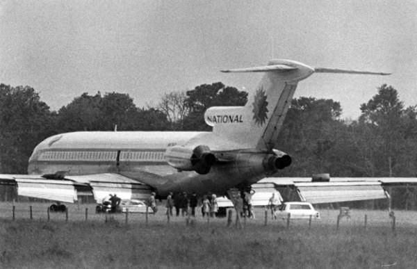
A July 1972 photo of the hijackers leaving the National Airlines 727 at Lake Jackson Airport.
After the hijacking drama was concluded, the only thing left to work out was how to get the 727 off the runway.
Maintenance crews replaced the blown tires and - to keep the aircraft’s weight down for takeoff -
put just enough fuel in the plane to get it to Houston Intercontinental on July 14.
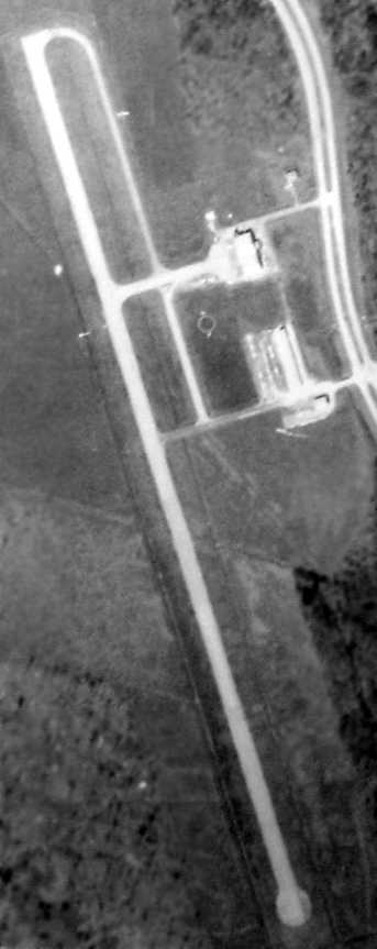
The last photo which has been located showing the Lake Jackson Airport still in operation was a 1974 aerial photo (courtesy of Adam DeLand).
It depicted the field as having 2 small hangars on the northeast side, which what appears to have been several light aircraft parked on the southernmost hangar.
At some point between 1963-75 the airport was renamed Brazoria County Airport,
as that is how it was labeled on the February 1975 Houston Sectional Chart.
It depicted Brazoria County Airport as having a single northwest/southeast 5,000' paved runway.
The Lake Jackson Brazoria County Airport was depicted in the 1978 TX Airport Directory (courtesy of Chris Kennedy)
as having a single 5,000' asphalt Runway 15/33, and 2 hangars along the east side.
The manager was listed as W. W. Lowrey.
The directory included the note: "New airport under construction for Brazoria County!"
A new Brazoria County Airport was built 5 miles to the north at some point between 1978-83, at which point the original field was evidently closed.
By the time of a 1983 aerial photo (courtesy of Adam DeLand), a road had been built cutting across the southern end of the runway,
and it appeared as if at least one hangar had been removed.
But the field remained otherwise still intact.
By the time of the 1985 TX Airport Directory (courtesy of Steve Cruse),
the original Lake Jackson Airport was no longer listed.
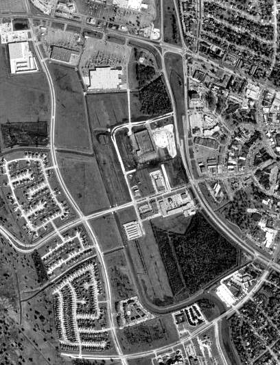
The 1995 USGS aerial photo showed that the field had been completely replaced by new roads & commercial buildings,
with only vestiges of the runway still being visible.
Ironically, the 1995 USGS topo map still depicted the former Lake Jackson Airport as being intact,
even though the aerial photo from the same year showed that most of the former airport had been removed.
A 2/16/10 aerial photo showed that the Lake Jackson Airport site had been completely replaced by new roads & commercial buildings,
with only vestiges of the runway still being visible.
The site of Lake Jackson Airport is located southeast of the intersection of Oyster Creek Drive & Lake Road.
Thanks to Bret Kepner for pointing out this airfield.
____________________________________________________
Since this site was first put on the web in 1999, its popularity has grown tremendously.
If the total quantity of material on this site is to continue to grow,
it will require ever-increasing funding to pay its expenses.
Therefore, I request financial contributions from site visitors,
to help defray the increasing costs of the site
and ensure that it continues to be available & to grow.
What would you pay for a good aviation magazine, or a good aviation book?
Please consider a donation of an equivalent amount, at the least.
This site is not supported by commercial advertising –
it is purely supported by donations.
If you enjoy the site, and would like to make a financial contribution,
you
may use a credit card via
![]() :
:
Please consider checking the box to make a monthly donatation.
For a mailing address to send a check, please contact me at: paulandterryfreeman@gmail.com
If you enjoy this web site, please support it with a financial contribution.
please contact me at: paulandterryfreeman@gmail.com
If you enjoy this web site, please support it with a financial contribution.
____________________________________________________
This site covers airfields in all 50 states.