Abandoned & Little-Known Airfields:
Texas: Northern Fort Worth area
© 2002, © 2024 by Paul Freeman. Revised 10/9/24.
This site covers airfields in all 50 states: Click here for the site's main menu.
____________________________________________________
Please consider a financial contribution to support the continued growth & operation of this site.
Alta Vista Airport (revised 12/18/22) - Flying G Airfield / Goode Airport (revised 12/31/23) - Fort Worth Dirigible Mooring Station & Airfield (added 12/14/13)
Globe Aircraft Company Factory Airfield / Bell Globe Heliport (revised 10/9/24) - Lane Field (added 11/26/22) - Mangham Airport (revised 12/4/23)
Pops Field / Blue Mound Airport (revised 12/10/21) - Ritchey Field (revised 10/19/19)
____________________________________________________
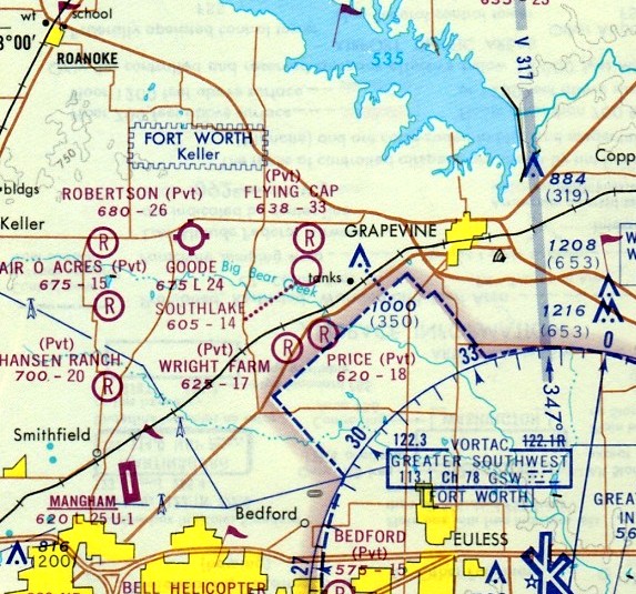
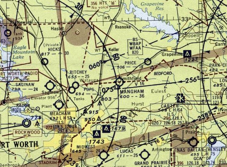
33.366, -97.146 (North of Ft. Worth, TX)
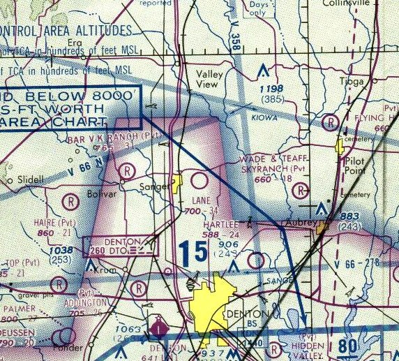
Lane Field, as depicted on the 1978 Dallas Sectional Chart.
Photo of the airfield while in use is not available.
This small general aviation airport was evidently established at some point between 1966-78,
as it was not yet depicted on a 1958 aerial photo, the 1960 USGS topo map, or the July 1966 Dallas Sectional Chart.
The earliest depiction which has been located of Lane Field was on the 1978 Dallas Sectional Chart.
It depicted Lane Field as a public-use airport having a 3,400' unpaved runway.
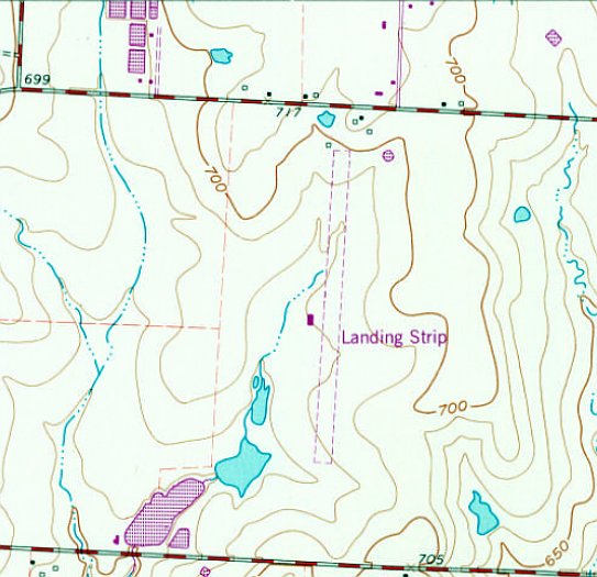
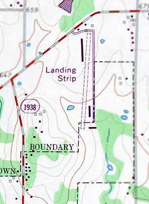
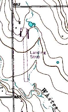
The 1978 USGS topo map depicted Lane Field as a single unpaved north/south runway, generically labeled “Landing Strip”,
with a single small building on the west side.
Carl Rousseau recalled, “I landed at Lane Field in 1979 or 1980 (since it was on my Sectional as a public field),
but the hangar was locked & no one was around, so I continued on my way.”
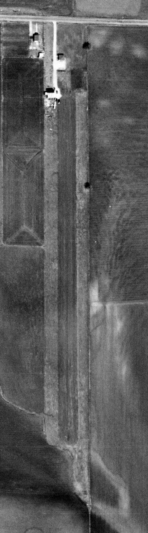
The earliest photo which has been located of Lane Field, and the only photo which has been located showing an aircraft there, was a 1981 aerial view.
It depicted Lane Field as having a single grass north/south runway, with a small hangar & 1 light single-engine plane on the west side.
The 1985 USGS topo map depicted Lane Field as a single north/south runway.
The earliest photo which is available of Lane Field was a 1995 USGS aerial view looking northeast.
It depicted Lane Field as having a single grass north/south runway, with a single small building on the west side.
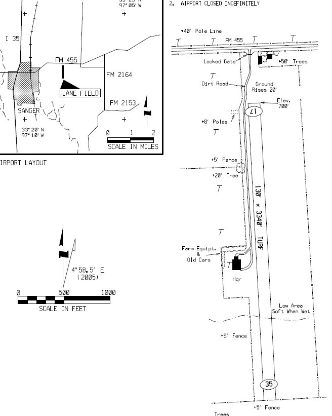
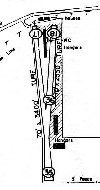
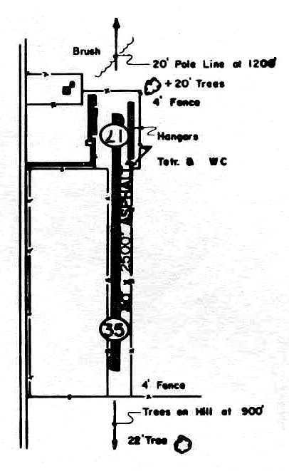
A 2/10/13 diagram from the FAA 5010 Directory (courtesy of Randy Coller) depicted Lane Field as a single 3,340' turn Runway 17/35, with a single small hangar on the west side,
but the remarks indicated “Airport closed indefinitely.”
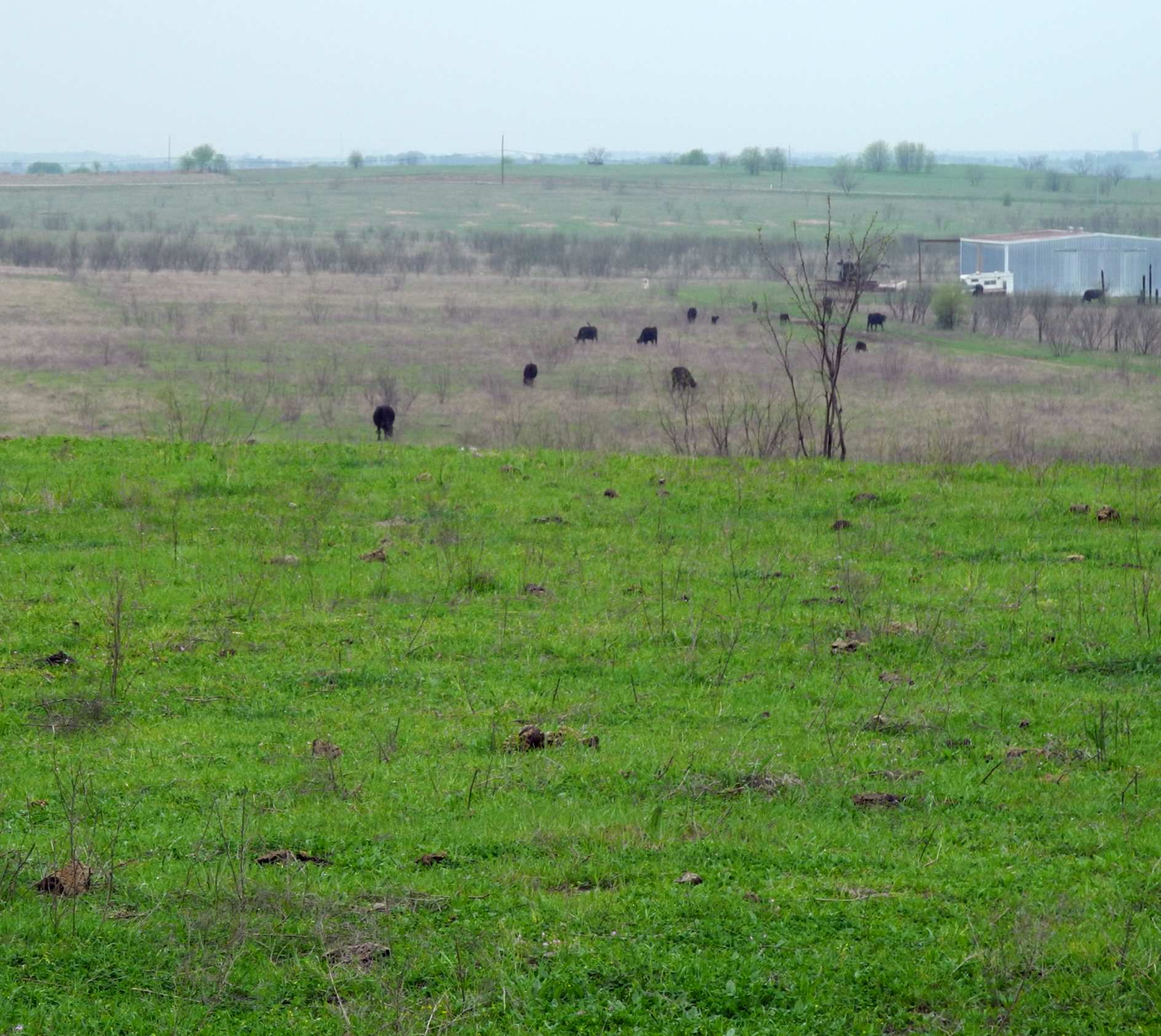
Randy Coller reported, “Lane Field... I've inspected this airport since about 2013. Since 2013 it has been pasture for cows, not suitable for aircraft.”
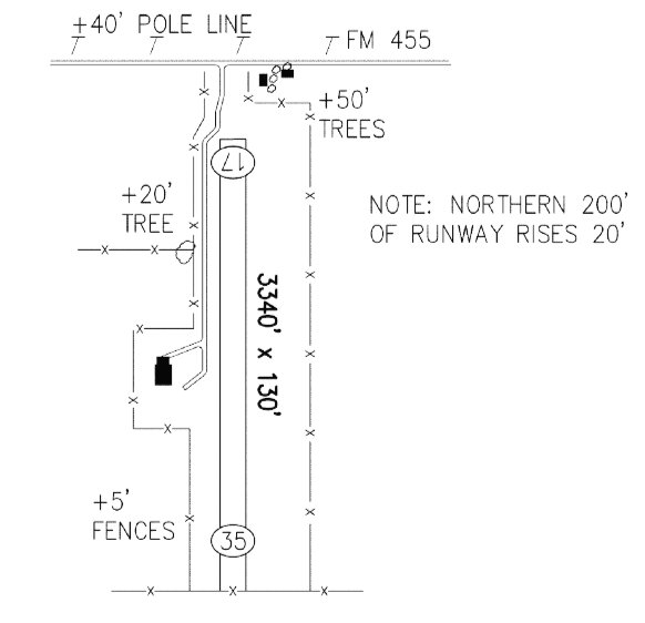
A 2/16/16 diagram from the TX Airport Directory (courtesy of Randy Coller) depicted Lane Field as a single 3,340' turn Runway 17/35, with a single small hangar on the west side,
but the remarks indicated “Airport temporarily closed.”
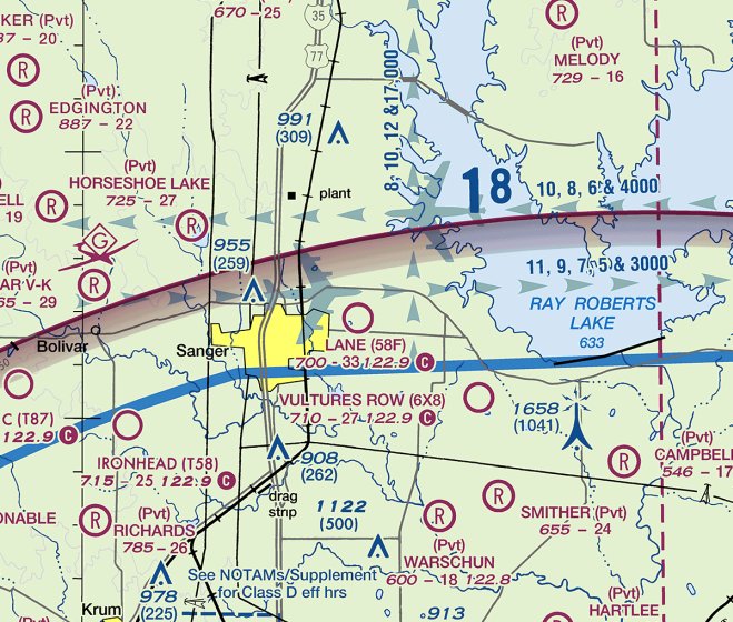
The last aeronautical chart depiction which has been located of Lane Field was on the September 2018 Dallas Terminal Chart.
It depicted Lane Field as a public-use airport having a 3,300' unpaved runway.
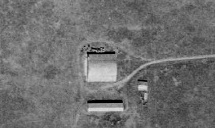
A 2019 photo by Randy Coller looking south along the former Lane Field runway, with the former hangar on the west side.
A 2019 photo by Randy Coller of the current residents of the former Lane Field.
Randy Coller reported, “Lane Field... In 2019, I managed to get all the paperwork in required by the FAA to abandon the site It's now off the charts.”
Lane Field owner Eddie Lane reported, “The effective date of the abandonment is 5/17/19.”
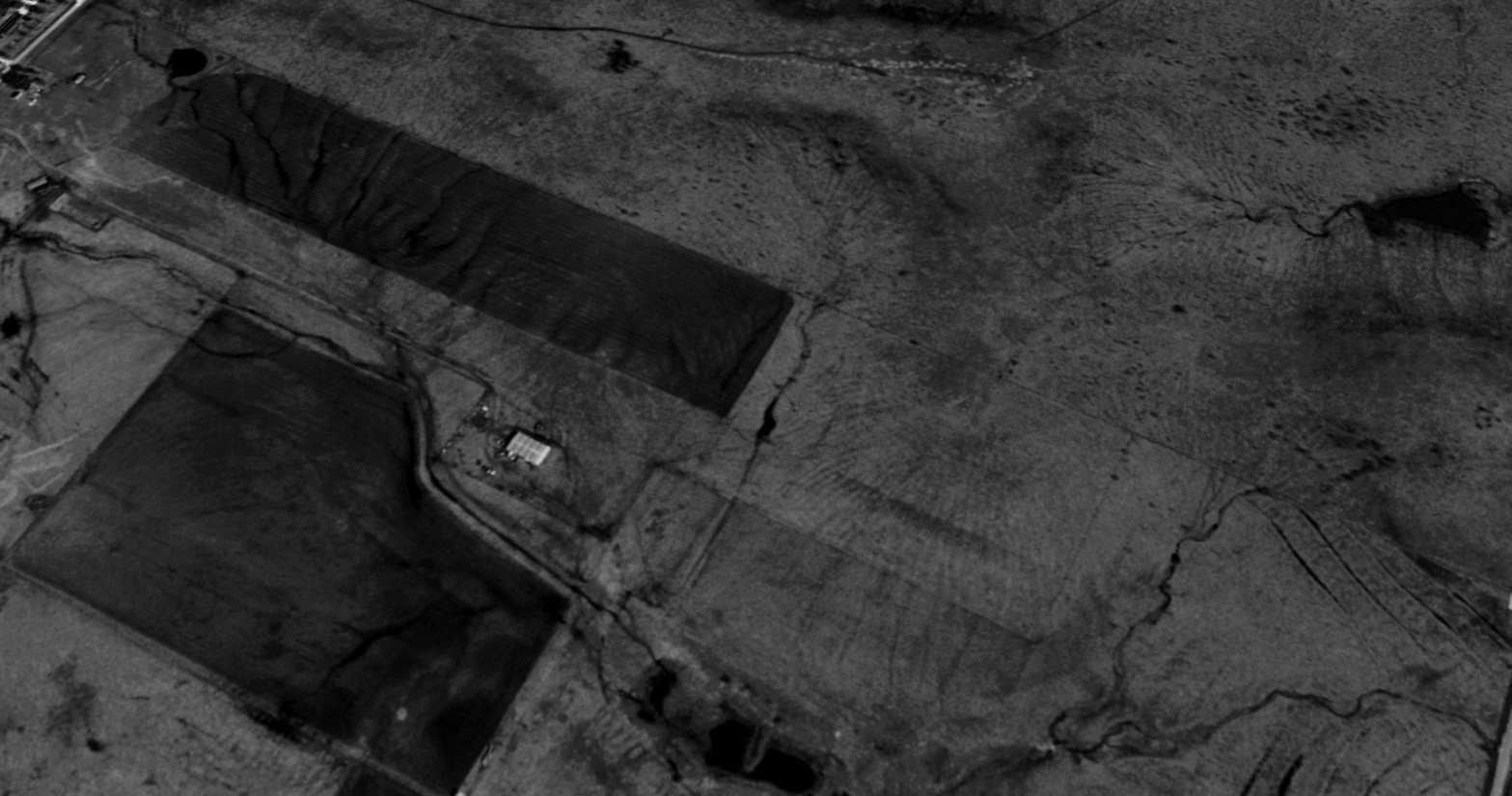
A 2022 aerial view looking northeast showed Lane Field's runway & hangar remained intact.
Thanks to Randy Coller for pointing out this airfield.
____________________________________________________
Fort Worth Dirigible Mooring Station & Airfield, Fort Worth, TX
32.83, -97.34 (East of Meacham Airport)
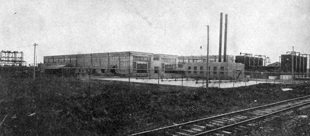
A 1923 photo looking southeast at the Fort Worth helium plant adjacent to the dirigible mooring station (courtesy of Bill Morris).
Bill Morris reported, “Helium was discovered in the 1880s & was found to exist in natural gas deposits,
but generally in infinitesimal quantities which made extraction cost prohibitive.
In 1917, natural gas deposits in the Petrolia fields in Clay County were found to have a sufficient quantity of helium to make extraction possible
and the Army & Navy constructed an experimental plant in Fort Worth, not far from the site of present-day Meacham Field.
They also constructed a pipeline to bring the gas from Clay County.
In 1920, the Army & Navy funded construction of a full scale production plant adjacent to the experimental plant.”
Bill continued, “The site was originally referred to as an 'argon gas facility' to hide its true purpose.
The plant was the world’s only source of helium which had been declared a strategic natural resource.
In 1924, the Navy constructed a dirigible mooring station near the plant to service Army & Navy airships on cross-country flights.
The US Navy’s ZR-1 Shenandoah & ZR-3 Los Angeles, as well as smaller US Army airships stopped in Fort Worth between 1924-28 to replenish helium & take on supplies.”
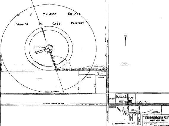
A 1924 US Navy Bureau of Yards & Docks plan of the “U.S. Helium Production Plant”, showing the dirigible mooring station to the northwest (courtesy of Bill Morris).
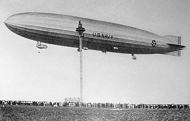
The only photo which has been located of a dirigible moored at the Forth Worth Dirigible Mooring Station
was a remarkable 10/9/24 photo (courtesy of Bill Morris) of the massive (680' long) ZR-1 Shenandoah, with a large crowd of spectators.
Bill Morris reported, “In 1925, operation of the plant was turned over to the US Bureau of Mines.”
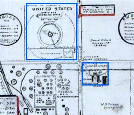
The U.S. Navy helium production plant & dirigible mooring station outlined in blue on a 1925 Fort Worth street map (courtesy of Bill Morris).
According to Bill Morris, “The plant closed in April 1929 when the natural gas fields in Clay County were depleted.
By then, a larger helium-rich natural gas deposit had been discovered near Amarillo & a new plant was built there.
Much of the equipment in the Fort Worth plant was moved to Amarillo.”
Bill continued, “After the helium plant closed, the Airways Division of the Lighthouse Service in the Department of Commerce took over the site.
There they developed early airways navigation lighting systems, established airport lighting standards,
and fabricated much of the early aviation radio communications systems for the Civil Aeronautics Agency.
The buildings eventually housed the Southwest Regional Office for the CAA.”
The Fort Worth Dirigible Mooring Station was not depicted at all on the 1932 Dallas Sectional Chart,
or subsequent aeronautical charts.
A 1936 aerial photo (courtesy of Bill Morris) showing the proximity of the remnants of the mooring mast site (the circular feature in the upper right) to Meacham Field at the bottom left.
Bill Morris observed, “The concrete pilings for the mooring mast & the anchor pilings on the 500' radius circle were still visible.”
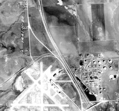
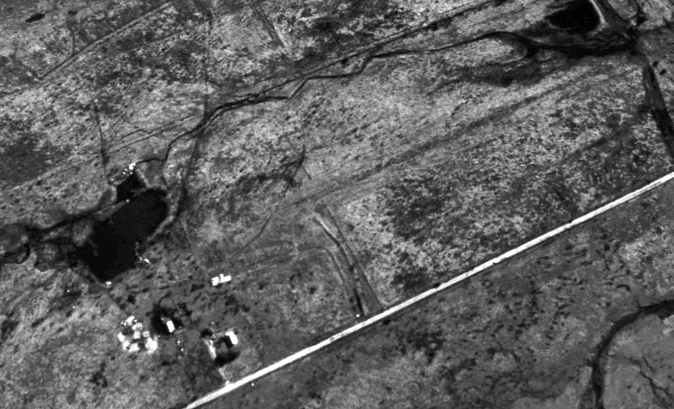
A 4/10/52 USGS aerial photo showing the faint trace of the remnants of the mooring mast site (the circular feature in the upper left),
the buildings at the site of the helium plant (bottom-center), along with a 2 runway airfield to the north of the helium plant.
The purpose of these runways has not been determined.
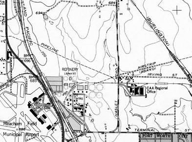
The 1955 USGS topo map depicted a single northeast/southwest runway, labeled “Airstrip (aban'd)”.
The buildings of the former helium plant were labeled as “CAA Regional Office”.
The 2 runways to the north of the former helium plant were still visible on a 1963 aerial photo,
along with the faint remnants of the dirigible mooring circle.
The January 1948 DFW Local Aeronautical Chart (courtesy of John Price) labeled a “plant” at the site,
but did not depict the runways.
The 1969 USGS topo map showed that a building had been constructed over the southwestern end of the runways.
A 1970 aerial photo showed that the last traces of the mooring circle were gone, with just an empty field on the site.
A 1979 aerial photo showed that a road & several buildings had been built over the site of the mooring circle.
According to Bill Morris, “The Federal Aviation Administration occupied the site [of the former helium plant] until their new headquarters was built in 1994.”
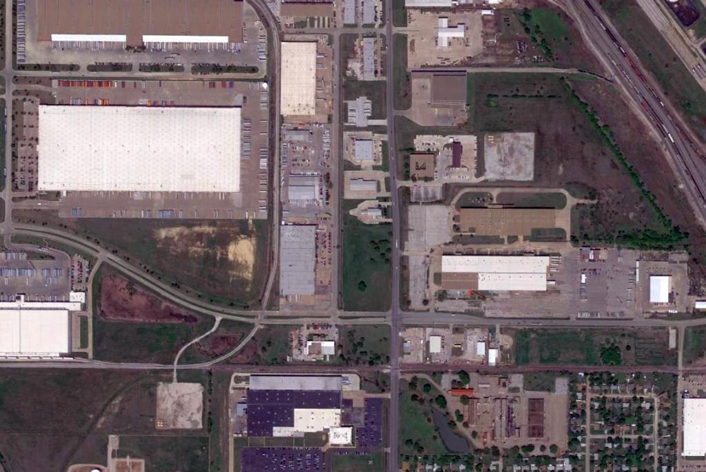
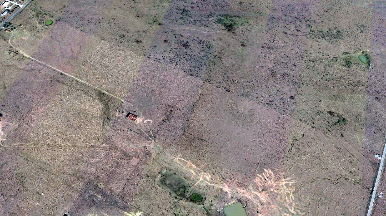
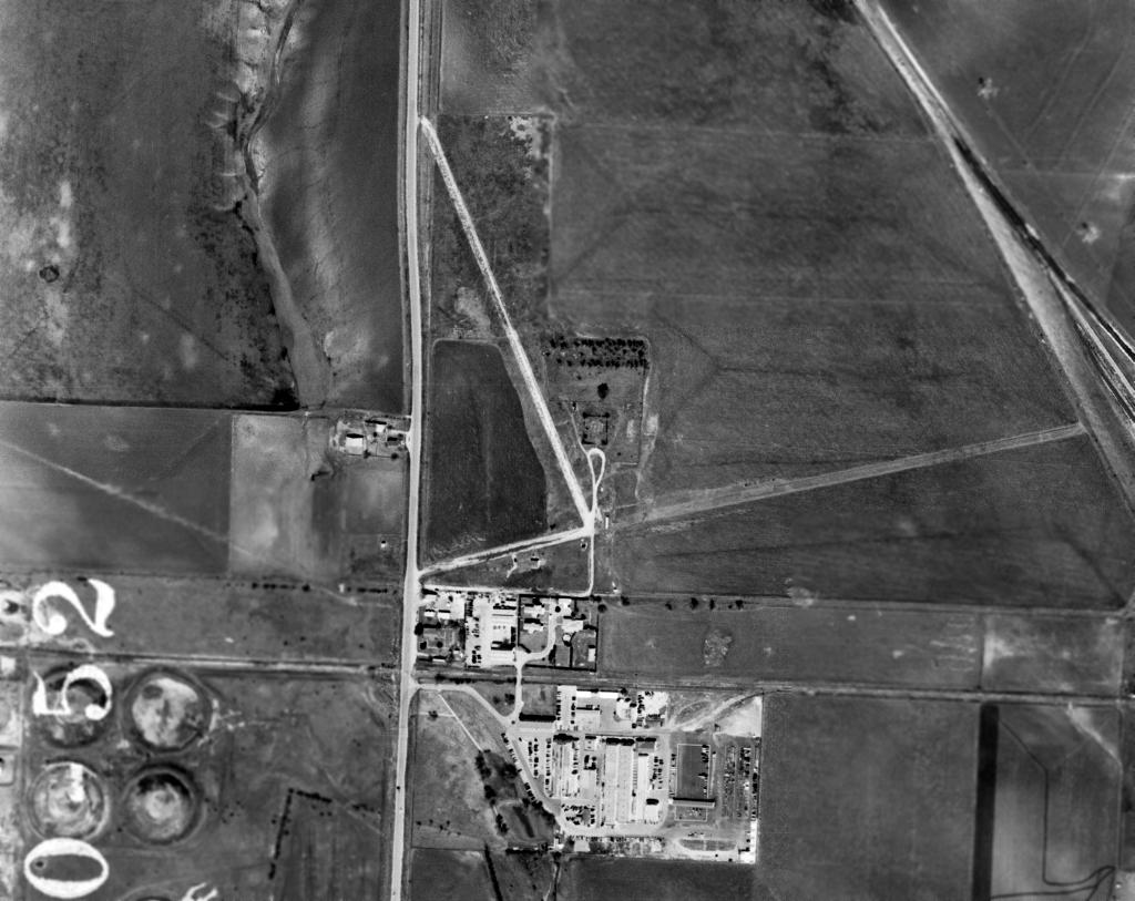
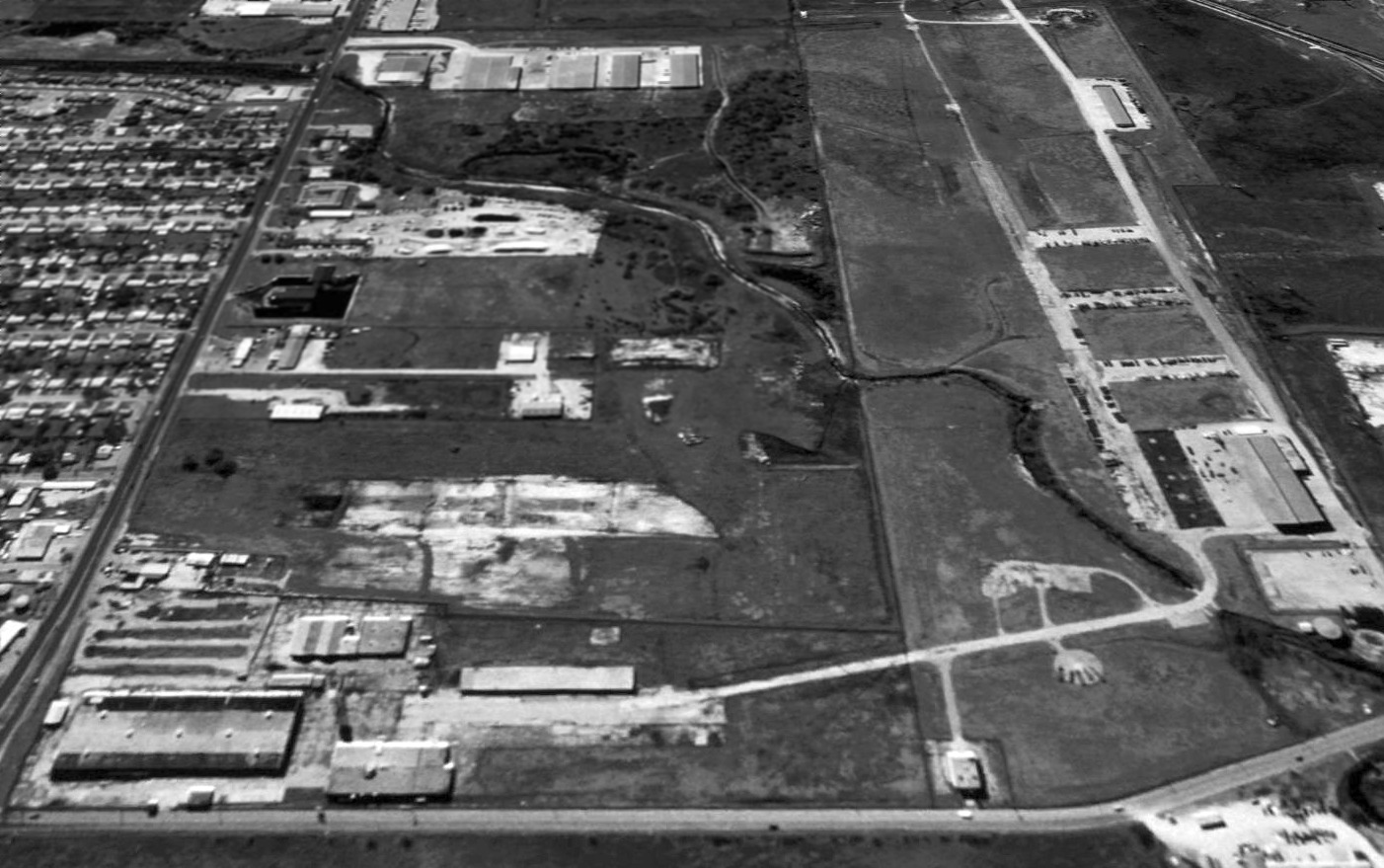
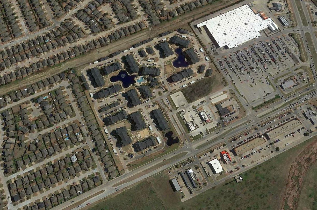
A 4/10/13 aerial view of the site of the Fort Worth Dirigible Mooring Station, Airfield, and Helium Plant.
Bill Morris observed, “The large pond on the production plant site (bottom center) was not landscaping - it was used to cool the power generating equipment in the helium separation building.
The 1918 experimental plant was located in the rectangular area above the main plant site.
The large building near the center of the mooring station site (top left) is a Mattel distribution center.
The north-south road at the eastern edge of the mooring site is Blue Mound Road & the east-west road across the bottom of the site is Meacham Boulevard.”
There was no trace remaining of the runways.
____________________________________________________
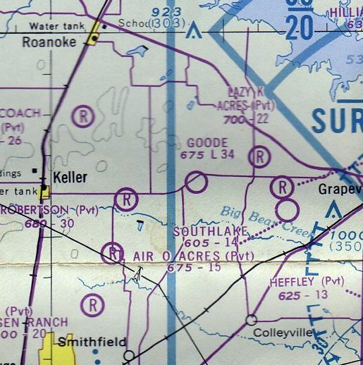
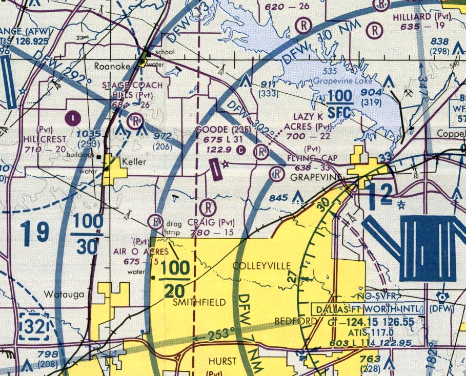
Flying G Airfield / Goode Airport (23F), Southlake, TX
32.94, -97.18 (Northwest of Dallas Fort Worth Airport)
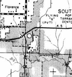
“Flying G (Private)” Airfield, as depicted on the 1963 Tarrant County TX Highway Department Map (courtesy of Gainey Bradfield).
This little general aviation airport was evidently built at some point between 1959-63,
as it was not yet depicted on the 1959 USGS topo map nor on a 1963 aerial photo.
The earliest depiction which has been located of this airfield
was on the 1963 Tarrant County TX Highway Department Map (courtesy of Gainey Bradfield).
It depicted the “Flying G (Private)” Airfield as having a single north/south runway.
However, Flying G Airport was not depicted at all on a 1963 aerial view,
which merely showed an open grass field at the eventual site of the airport.
Nor was Flying G Airport depicted on the 1966 DFW Local Aeronautical Chart (courtesy of John Price),
or the 1968 USGS topo map.

The earliest photo which has been located of Flying G Airport was a 5/1/68 USGS aerial view.
It depicted Goode Airport as having a single grass north/south runways, with 3 light single-engine aircraft parked on the northeast side.
There were not yet any hangars on the field.
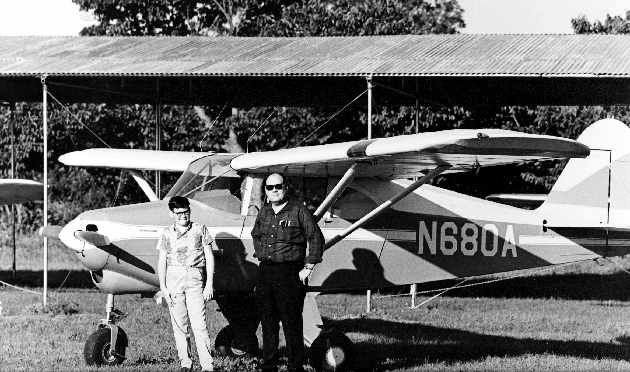
A 1968 picture by Bruce Norman of Leland & Dwayne Burns in front of their Piper Tri-Pacer at Flying G Airport (courtesy of Leland Burns).
Leland recalled, “The photo was taken on one of our early outings.
Bruce had flown over from south Fort Worth just to see the new airstrip & hangars & all that Bob Goode had put together.”
Leland Burns recalled, “I sort of grew up at Bob's [Bob Goode's] original place.
My dad worked with Bob at Bell Helicopter - both were engineers.
My father, Dwayne Burns, owned a Piper Tri-pacer that had a really great interior.
Dad [Dwayne Burns] was sharing with me that he had helped Bob put up the first hangar (in photo)
and he also had a big hand in fencing in the airfield before Bob opened it up for rentals.
Bob Goode brought dad a sketch one day & the 2 of them worked out a set of house plans in their off hours.
Then the 2 of them built the house around the corner from the airstrip.
Bob wanted to buy the 20-odd acres between his house & the airfield.
He bought out one guy shortly after dad started flying there.
There may have been a few tie-downs but the first hangar wasn't built until approximately 1968.
Dad had Bob reserve him a space dead center of the hangar.
The hangar was still incomplete but close enough when dad bought the Tri-pacer.
This 1st hangar ran north/south & in the [aerial] photo is the middle (or furthermost south) north/south hangar.
This first hangar was also the end of the original runway, 2,000' by my memory.
After that he built all east to west hangars until I stopped going.”
Flying G Airport was not yet depicted on the 1969 DFW Sectional Chart (courtesy of Ron Myres).

A 1970 aerial view of Flying G Airport showed the field to have 2 closely-aligned grass runways,
with a row of T-hangars each at the north & south ends of the field.
Five single-engine aircraft were visible parked outside at the field.
At some point between 1963-76, the airfield was evidently renamed “Goode”,
as that is how it was labeled on the July 1971 Dallas Sectional Chart Dallas inset (courtesy of Ron Plante)/
It depicted Goode Airport as having a 2,400' unpaved runway.
The 1973 USGS topo map depicted Flying G as having a single unpaved runway, labeled simply as “Landing Strip”,
with hangars on the northwest & southeast sides. A 3rd hangar had been added at the south, at some point between 1970-73.
Flying G Airport still was not depicted on the February 1973 Dallas Sectional Chart (courtesy of Ron Plante).
The July 1976 Dallas Terminal Aeronautical Chart (courtesy of Jim Hackman) depicted Goode as a public-use airport having a 3,400' unpaved runway.
The 1978 TX Airport Directory (courtesy of Chris Kennedy) depicted Goode Airport as having 2 turf runways (with the longest being the 3,400' Runway 17/35),
with the airport property having been extended somewhat further south at some point between 1970-78.
One hangar was situated in the narrow parcel of land in between the north ends of the 2 runways,
while 2 other hangars were located on the southeastern end of the field.
The manager was listed as R. G. Goode.
A 1979 aerial view showed that the Goode Airport's northern T-hangar had been extended toward the south, compared to the 1970 photo.
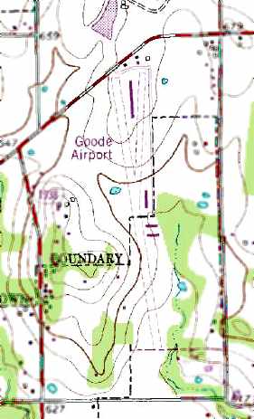
The 1981 USGS topo map depicted Goode Airport as having 2 unpaved runways, with 4 hangars along the east side.
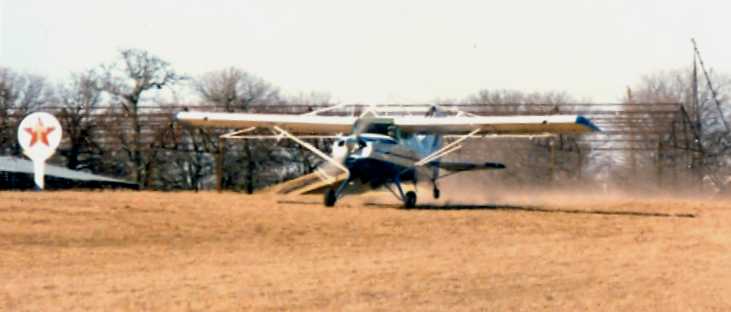
A 2/19/81 photo by Zane Adams of a Maule M-5 taking off from Goode Airport.
The 1982 AOPA Airport Directory (courtesy of Ed Drury) described Goode Airport as having 2 closely-aligned turf runways: 3,400' Runway 17/35 & 2,600' Runway 18/36.
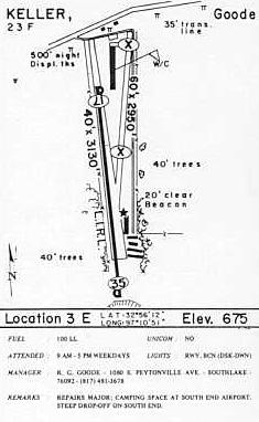
By the time of the 1985 TX Airport Directory (courtesy of Steve Cruse),
Runway 17/35 had been paved (3,130' long), while the other runway had been abandoned.
The operator was listed as R. G. Goode.
Isaias Cruz recalled, “I flew back in the late 1980s as a flight instructor & knew Mr.Goode by flying out of Goode Field.
I owned a C-152 & kept it at his airport. I remember him talking about the builders trying to move/buy him out.
He was a wonderful man, aviator & mechanic.”
Bill Darden recalled, “I flew a Cessna 310 in & out of Goode from 1989-90.”
A 1990 aerial view showed an amazing number of hangars at Goode Airport – a total of 23 hangars.
The last aeronautical chart depiction which has been located of Goode Airport was on the June 1993 DFW Terminal Chart (courtesy of Jonathan Westerling).
It depicted Goode as having a single northwest/southeast 3,100' paved runway.
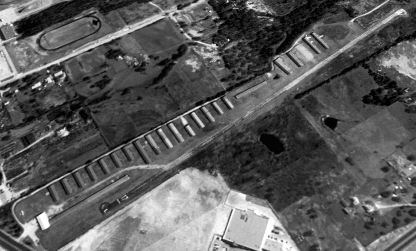
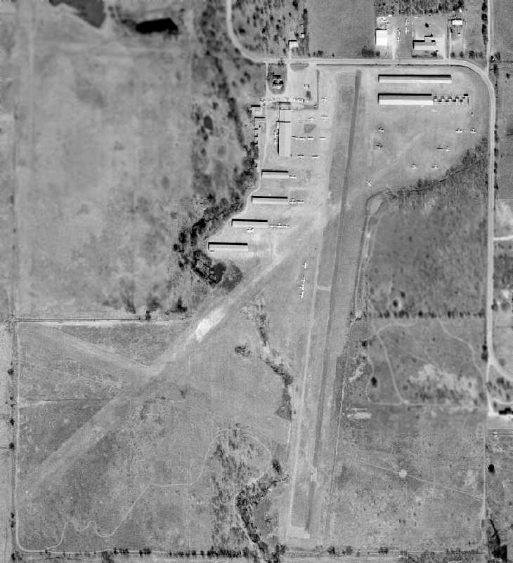
Goode Airport was apparently quite well-used, due to a total of 21 hangars which were visible in a 1995 USGS aerial view looking southeast.
It was located on an extremely tight little parcel of land - the entire airfield property was a mere 500' wide!
Mike Palmer recalled, “We flew our Glasair into Goode Field (23F) in January 1996.
It was fairly run down then, but still usable (hangars were more like open barns).
That was a particularly cold week... they had freeze warnings up for the night
and the owner was draining the water fountain as we were unloading so the pipes wouldn't crack.
I remember the hotel driver had a hard time finding the field, it was that obscure.”
Palmer continued, “Getting ready to come home, our main tank fuel drain stuck open after taking a fuel sample during preflight.
It was about 20 degrees (F) that morning. The owner of the field was very helpful.
Amazingly, the old timer had a new drain in his inventory & helped me replace the drain in situ,
offering me some empty bread bags to cover my hands & elbows as fuel poured all over me during the change out.
It was a piece of fiberglass stuck in the drain. I now carry a spare drain in the plane.”
According to Paul Quinn (who lives right across the street),
"Goode succumbed to progress & was the last privately-owned airport left in Tarrant County. It closed in 1998."
The closure of the little airport was no doubt ensured by its location,
smack in the middle of what has become a rapidly developing upscale suburb.
It was also located a mere 7 miles east of what has become one of the world's busiest airports, Dallas Fort Worth International.
Goode Airport was no longer depicted on the October 1998 DFW Terminal Aeronautical Chart (courtesy of Ron Plante).
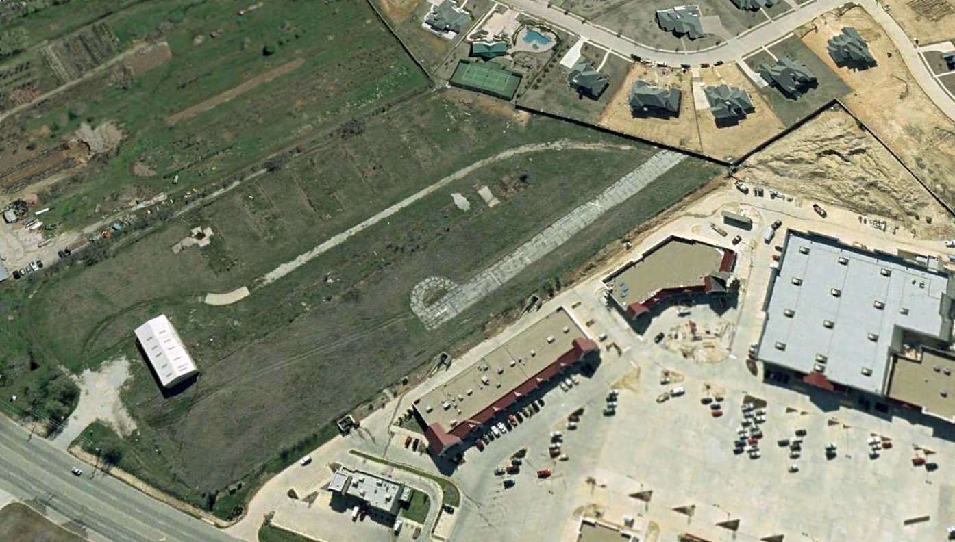
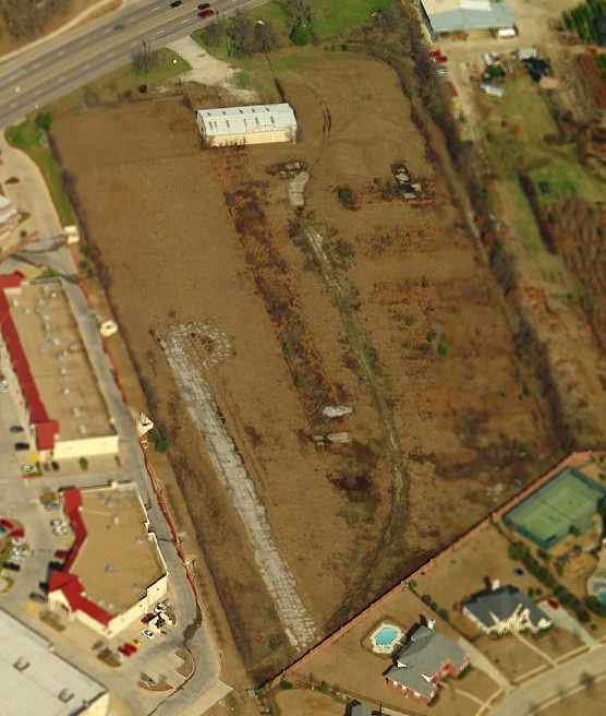
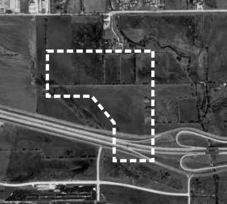
A 2001 aerial view looking southeast at the truncated remaining portion of the former Goode Airport runway & hangar,
along with the housing development which had covered most of the airport property.
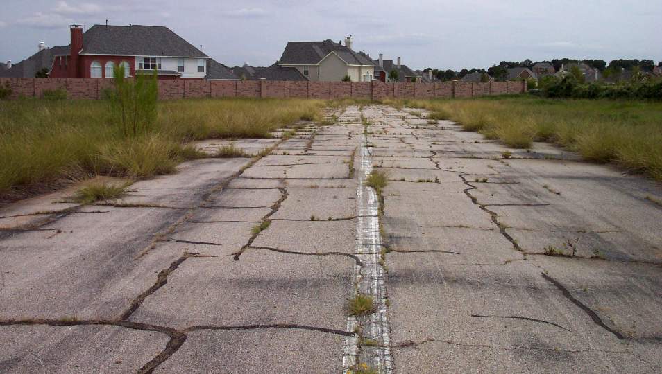
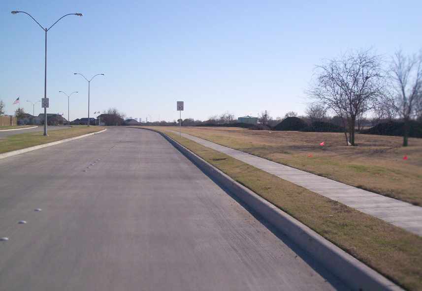
A 2002 photo by Paul Freeman looking south along the remaining 500' of Goode Airport's runway -
a sad view of the remains of a former nice little general aviation airport, along with the reason for its demise - new homes.
The remaining runway pavement runs right up to the wall surrounding the new housing development.
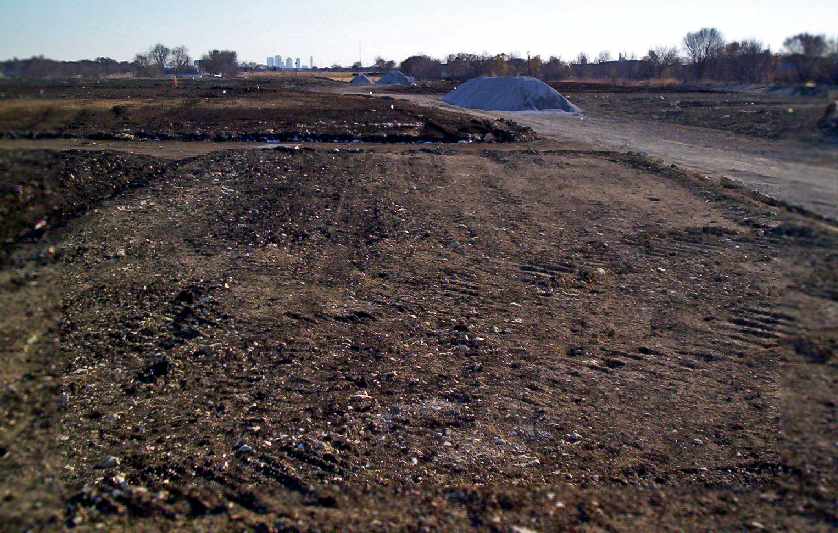
Paul Freeman visited the site in 2002, to find a sad sight -
the southern half of the property had been obliterated by the construction of a new housing development.
Only an 1,100' x 500' portion of the airport property remained intact,
and it was marked with a "For Sale" sign.
However, that portion contained the primary hangar, which still stood,
as well as a 500' portion of the runway,
which was abruptly brought to an end by a new wall surrounding the housing development
which had been built over the southern portion of the former airport property.
The runway segment was extremely overgrown,
as were portions of a concrete taxiway which led from the hangar to the runway.
The trash-strewn hangar even contained the junked rear fuselage of a light aircraft, looking very forlorn
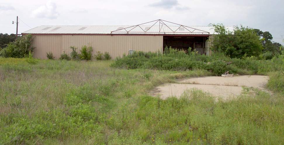
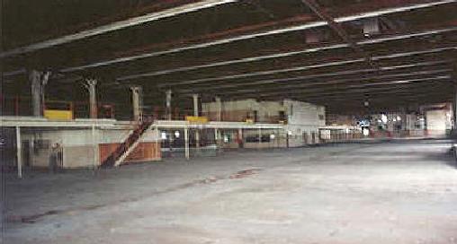
A 2002 photo by Paul Freeman of the exterior of the sole hangar which remains standing at Goode.
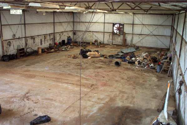
A 2002 photo by Paul Freeman of the trash-strewn interior of the sole remaining hangar at Goode.
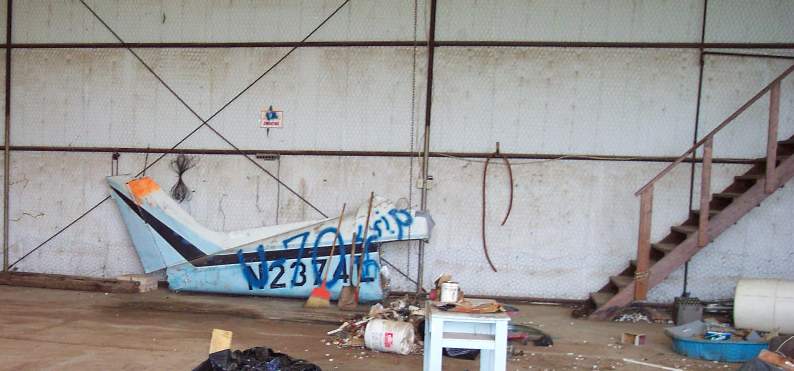
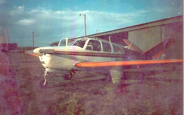
A 2002 photo by Paul Freeman of the only remaining aircraft at Goode Airport -
a sad looking rear fuselage of a Beechcraft Musketeer inside the hangar.
Leland Burns recalled, “The tail section in the last remaining hangar photo was from a plane owned by Bob [Goode].
His wife bought it for him - I think brand new; a Beechcraft Musketeer.
It seems Bob only had the plane for 12-18 months before he suffered a horrific crash.
The story I recall was the private field he was planning to land at had a tractor parked in the runway's middle.
After much circling & debate he tried to land just past the tractor.
He went long before touching down & when he realize he would not stop before hitting a wire fence he gunned the engine.
It was too late.
One wing clipped a fence post & the plane got jerked about moving sideway through the air 40-60 yards until hitting trees.
The plane pin-balled through the trees with the rear compartment completely gone.
The engine broke loose as well & Bob & his wife were setting in the largest piece remaining.
Bob was able to walk away but was deeply bruised EVERYWHERE.
His wife had a broken leg or ankle. Two of Bob's sons became pilots.
One took the engine from the Musketeer & placed it into a small stunt biplane.
A Mong Special or something like that.
The plane never flew however as they later decided it might be more engine than the plane could handle.”
The last truncated remains of the little Goode Airfield,
as seen in a circa 2002-2005 aerial view looking north at the remaining runway portion & hangar.
Unfortunately, Jay McPhail reported in June of 2005,
“Goode Airfield was torn down last month to make way for a soccer complex.
It remained as it was [described above] up until they tore it down.
Now nothing, not even the segment of runway, remains.”
Leland Burns reported in 2005, “I bought a house in Keller about 12 weeks ago hardly more than a mile from the old Goode strip.
Two or three weeks ago the last hangar was torn down to make way for a horse arena.
I'm glad it is not more houses.”
Leland Burns reported in 2008, “The last piece of the airfield is mostly covered by an indoor gym called the Stampede Arena,
a place for kids to play sports.”
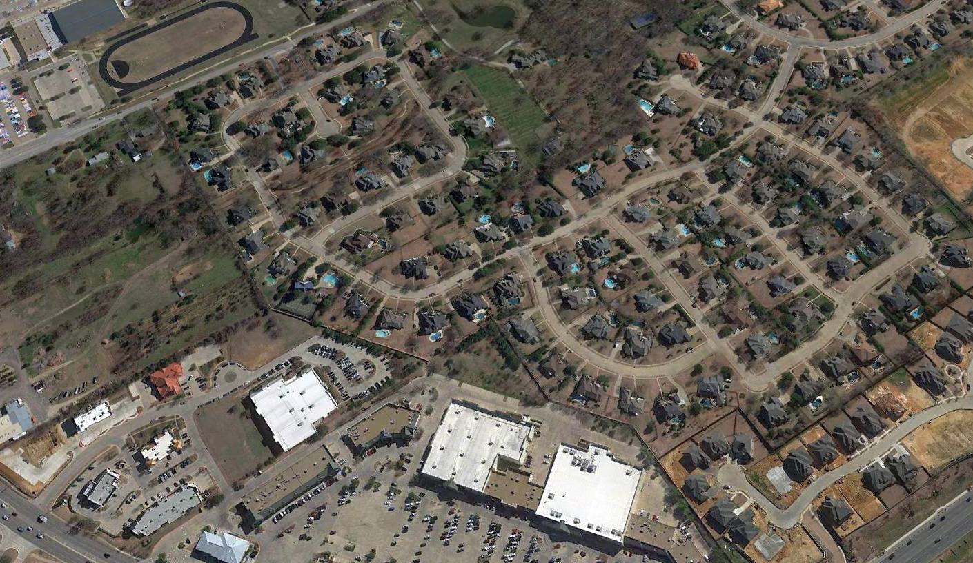
A 2016 aerial view looking southeast shows no trace remaining of Goode Airport.
A 5/10/20 photo by Bill Darden of the last remaining trace of Goode Airport: a “guideline visibility ball still marking the east edge of the old runway, along the sidewalk on 1709.”
The site of Goode Airport is located southeast of the intersection of Southlake Blvd. & Davis Blvd.
____________________________________________________
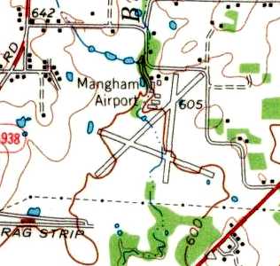
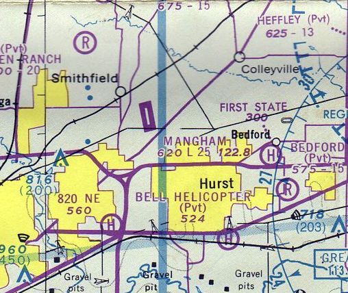
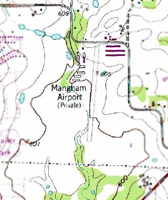
Mangham Airport (F70), North Richland Hills, TX
32.86, -97.2 (Northeast of Fort Worth, TX)
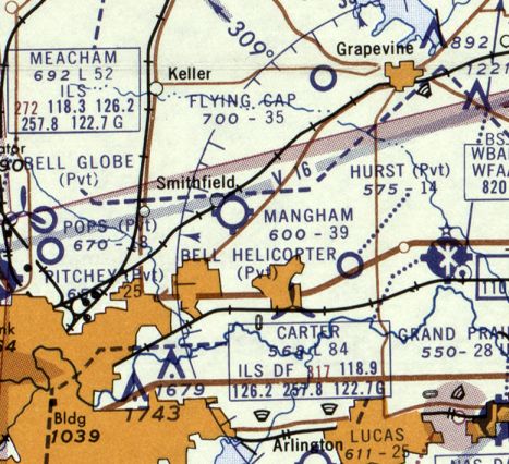
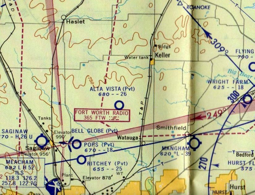
Mangham Airport, as depicted on the March 1956 Dallas Sectional Chart.
This general aviation airport was evidently built at some point in 1952,
as a 1952 aerial photo appeared to show the airport while under construction,
with the start of an unpaved north/south runway having been cleared.
Larry Hansard recalled, “Mangham Airport... I helped Charles Mangham build & run this airport.”
Mangham Airport still was not yet depicted on the September 1955 Dallas Sectional Chart.
The earliest aeronautical chart depiction which has been located of Mangham Airport was on the March 1956 Dallas Sectional Chart.
It depicted Mangham as having a 3,600' unpaved runway.
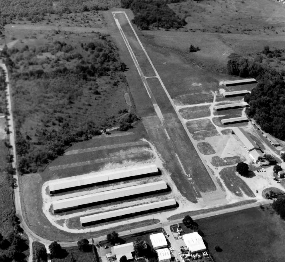
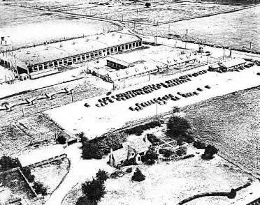
A 1956 aerial photo depicted Mangham as having 3 unpaved runways, and several hangars on the north side of the field.
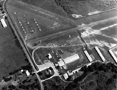
The earliest photo which is available of Mangham Airport was a circa 1950s aerial view (courtesy of Jerrell Baley).
It depicted the field as having at least 2 unpaved runways, with over 2-dozen light aircraft & several hangars on the north end of the field.
The 1959 USGS topo map depicted Mangham Airport as having 3 paved runways, and several hangars on the north side of the field.
The August 1960 Dallas Sectional Chart depicted Mangham as having a 3,900' unpaved runway.
The 1963 Tarrant County TX Highway Department Map (courtesy of Gainey Bradfield)
depicted Mangham as having 2 runways, oriented north/south & northwest/southeast.
A 1963 aerial photo depicted Mangham as having 3 unpaved runways, and several hangars on the north side of the field.
The 1964 DFW Local Aeronautical Chart (courtesy of John Price) depicted Mangham Airport as having a 2,600' paved runway.
Ganey Bradield recalled, “Mangham Airport was owned & run by a man named 'Stormy' Mangham.
He was a pretty colorful character.
He was one of the very early pilots for American Airlines.
His son, Charlie, did most of the hands-on daily operation for Stormy.
He had a running battle with Texas Electric Service Company -
wanting them to bury some lines on the north side of his airport,
so he wouldn't have to go over them on landing to the south.
One day, after a long 'hot' telephone conversation with them,
he stormed out of his hangar, asked me to prop his Aeronca Champ,
took of in a circle from his parking spot, and 'drug' it in over the wires for a landing -
intentionally grabbing the wires with his tailwheel.
Yep - he drug them down, without any major mishap, parked his plane & came in muttering -
'let them fix their dammed wires now... Oh my, I just accidentally came in a little low & snagged the wires... Too bad.' That was Stormy.
I was out there at the time because we kept our CAP Aeronca L-16 there & I was doing some maintenance on it.”
A 1970 aerial view depicted Mangham Airport as having a single north/south paved runway along with 2 grass runways.
The field had a total of 7 hangars, along with dozens of light aircraft visible parked outside,
including several aircraft on the other side of the road along the north side of the field.
Kerry Crawford recalled, "I flew out of Mangham Airport from 1974 until it closed.
When the DFW Terminal Control Area was a cone, the ceiling over the airport was 3,000'
and just east in was on the ground so you could not depart east.
Landing at night was always a challenge since the 20 lights lining the runway
looked like 60 watt bulbs from pattern altitude.
Because of growing neighborhood complaints, they installed a VASI for Runway 17, but still tiny lights.
There were hangars on both sides of the north end of the runway, so turbulence over the buildings was always fun."
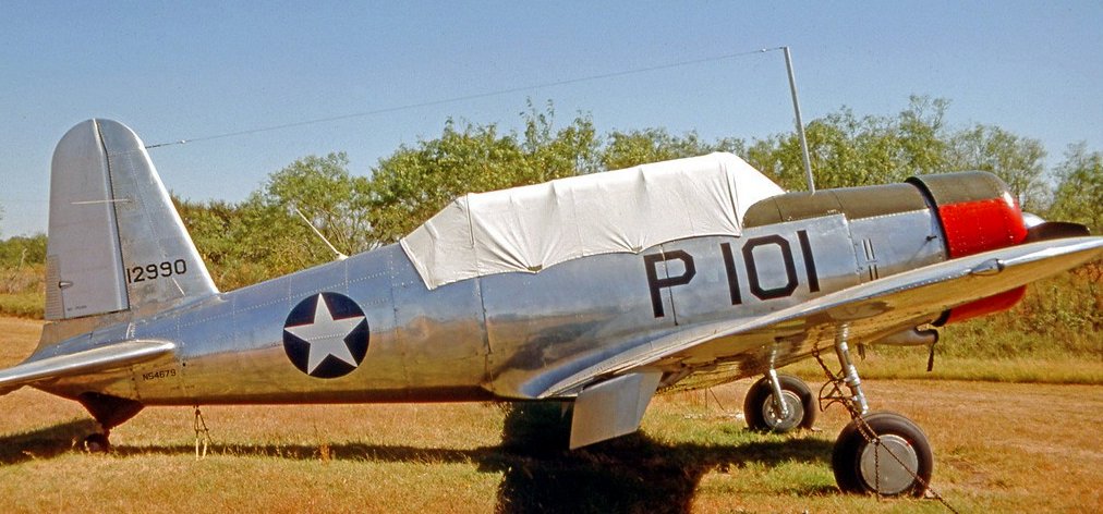
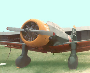
A 10/20/75 photo of a Vultee BT-13A Valiant at Mangham Airport.
The July 1976 DFW Terminal Chart (courtesy of Jim Hackman) depicted Mangham Airport as having a 2,500' paved runway.
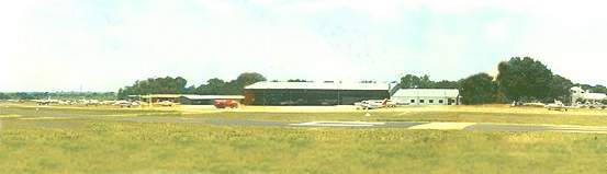
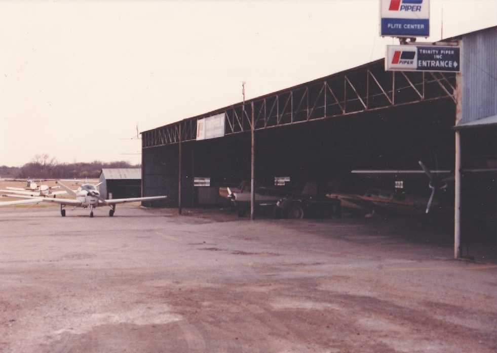
A circa 1976-77 photo of Mangham Airport by Cliff Knight. The photo is looking west, at the end of Runway 17, showing the FBO.
The building on the far right side was the owner's residence at one time, but later housed the Tarrant Aero Association.
Cliff "used to ride my bicycle to Mangham every Sunday & fly all day long with my Jr. High School band director."
A 1977 photo by Cliff Knight of a rare airplane which lived at Mangham:
a T-6 Texan which was modified into a replica of Japanese Val dive-bomber,
which was used in the filming of the movie "Tora Tora Tora".
It was owned by Robert Parcell, a Captain with Frontier Airlines who flew with Knight's father.
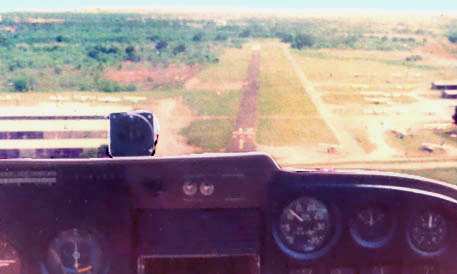
A 1978 aerial view by Clifton Knight from a Cessna 172 on final to Mangham's Runway 17.
The 1978 DFW Sectional Chart (courtesy of Ray Brindle) depicted Mangham as having a 2,500' paved runway.
Tim Carter recalled, "I was hired by Delta in 1978 & moved to North Richland Hills,
where I did some instructing at Mangham Field which was walking distance from my house.
Tarrant County Junior College had a flying department & a club at Mangham,
and I instructed a little in a Decathlon they had.”
A December 1979 photo by Zane Adams of a rare Government Aircraft Company N24A at Mangham Airport.
An October 1980 photo of a rare Noorduyn UC-46A Norseman C/n 561 N57WS at Mangham Airport.
Tim Carter recalled, "A friend & fellow Delta pilot, Bill Guy, owned a Piper dealership & school there in the early 1980s."
The 1981 USGS topo map depicted “Mangham Airport (Private)” as having a single north/south runway.
It did not depict the crosswind runway.
Several hangars were depicted on the northwest & northeast sides of the field.
Mangham Airport was listed among active airfields in the 1982 AOPA Airport Directory (courtesy of Ed Drury),
which described the field as having a 2,500' asphalt Runway 17/35 & a 2,800' turf Runway 10/28.
The operators were listed as Rose Aviation Service & Hurst Piper Inc.
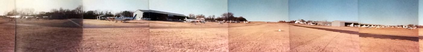
A 1983 panoramic photo by Tom Baker of numerous planes parked at Mangham Airport.
Tom recalled, “There was a loose organization of the regular patrons called the 'Airport Bums', even had patches made you could put on a ball cap or shirt.
The motto on the patch read 'Round Tuit'.”
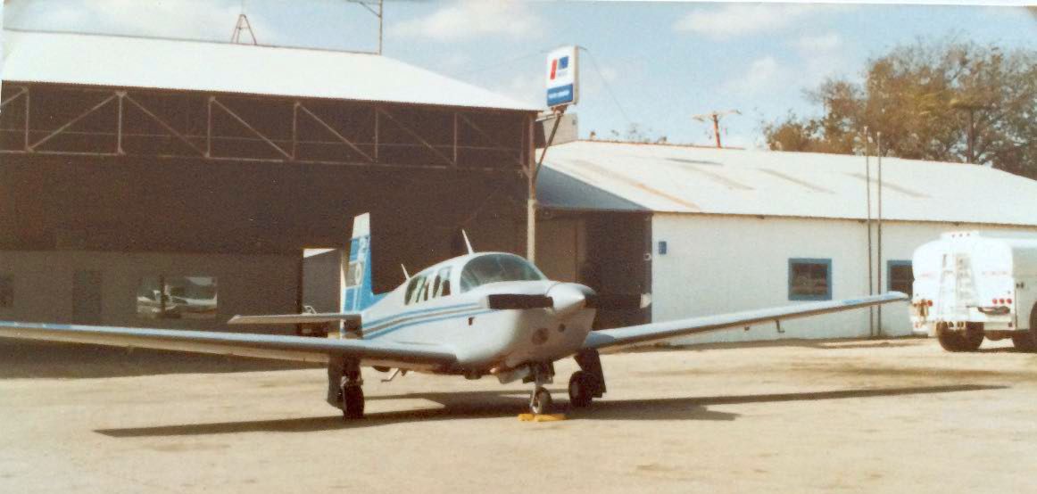
A 1983 photo by Tom Baker of a Mooney 201 in front of a Mangham Airport hangar.
A circa 1980s aerial view looking southwest at Mangham Airport (courtesy of Jerrell Baley).
Note the aircraft parked across the street in the foreground.
The last photo which has been located showing Mangham Airport while in operation was a 1982 photo of several planes inside a hangar by Tony DeFranco.
Tony observed, “Bills Flying service rented 152s & 172s and was owned by Bill & Jean Lemmon. Great people.”
The last aeronautical chart depiction which has been located of Mangham Airport was on the January 1984 Dallas Sectional Chart.
It depicted Mangham Airport as having a 2,500' paved runway.
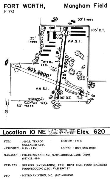
The runway configuration remained the same in the 1985 TX Airport Directory (courtesy of Steve Cruse).
A total of nine hangars were depicted at the north end of the airport, along with a small paved apron west of the Runway 17 approach end.
The manager was listed as Charles Manham, and the operator was listed as Metro Aviation Inc.
John Hoenmans recalled, “Mangham Airport... I learned to fly at this great little airport during the summer of 1985.
The pictures brought back many pleasant memories. Bill & Jean Lemmon ran the flight school at the time.
Chuck Rainey was my instructor. He was a retired Braniff pilot.
I spent many hours sitting on the porch of the little building that was the office, watching small planes come & go.”
Mac Hubbard recalled, “I instructed for Bill & Jean Lemmon at Mangham Field in 1985-86.
According to what I was told the field closed due the cost of installing new underground fuel tanks to meet federal regulations.
The family sold the property to developers, the runways were plowed soon thereafter, and the Manghams held a Texas size BBQ to close the field.
Hundreds of people showed up that had used the field over the years.
The highlight of the party was a low flyby from a B-52 from nearby Carswell AFB.”
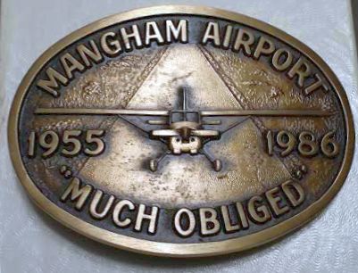
A photo of the belt buckle given to Bruce Townsend in appreciation of his 9/13/86 flyby on the occasion of Mangham Airport's closure.
Bruce recalled, “The flyby was in a B-52 from Carswell.”
Kerry Crawford recalled, "When they dropped the TCA [Terminal Control Area] to the ground is when Mangham closed.
Otherwise every aircraft would have to have gotten new radios & contacted DFW to depart, so they just closed it.
What I always wondered is where all the planes went.
There were hundreds there, some with an inch of dust & hadn't flown in years."
Mangham Airport was no longer depicted on the January 1988 Dallas Sectional Chart (courtesy of Ron Plante).
A 1990 aerial view showed that all of Mangham's hangars had been removed.
In a 1995 USGS aerial view, the remains of both Mangham Airport runways are still apparent,
as well as the foundations of the 3 hangars on the northeast corner of the property.
A 2001 aerial view showed the majority of the Mangham Airport site had been redeveloped.
Fred Carlson reported in 2006, “I live a few minutes away from the field.
The 3 hangars are still there & I think are being used for storage / workshops.
Under what appears to be a converted hangar there is the fuselage (minus wings) of an aircraft painted with 'Sharks Teeth'.
The actual airfield has been developed & virtually no trace remains.
Along the southwest side of Cardinal Drive there is a stone wall that could be part original offices.”
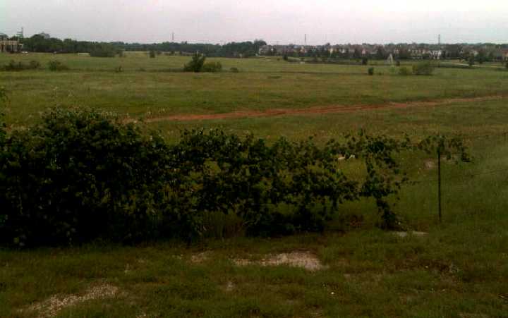
A 4/20/12 photo by John Hoenmans looking south along the site of Mangham Airport's Runway 17.
John observed, “There are no visible remains of the airport.
The buildings on the north side of Cardinal Drive remain.
They were obviously aircraft hangars that have now been repurposed.”
A 4/20/12 photo by John Hoenmans of broken-up remains of Mangham Airport's runway.
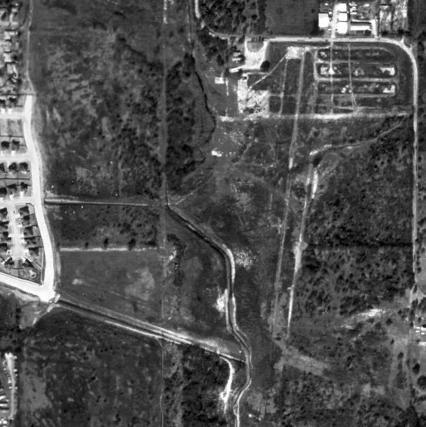
A 2016 aerial view showed the site of Mangham Airport was unrecognizable as having ever been an airport,
but a close inspection reveals that several of the airport buildings on the northeast of the site remain standing.
An October 2018 photo looking north at a former hangar which remains on the northeast portion of the Mangham Airport site.
Mangham Airport was located northwest of the intersection of Grapevine Highway & Cardinal Drive.
____________________________________________________
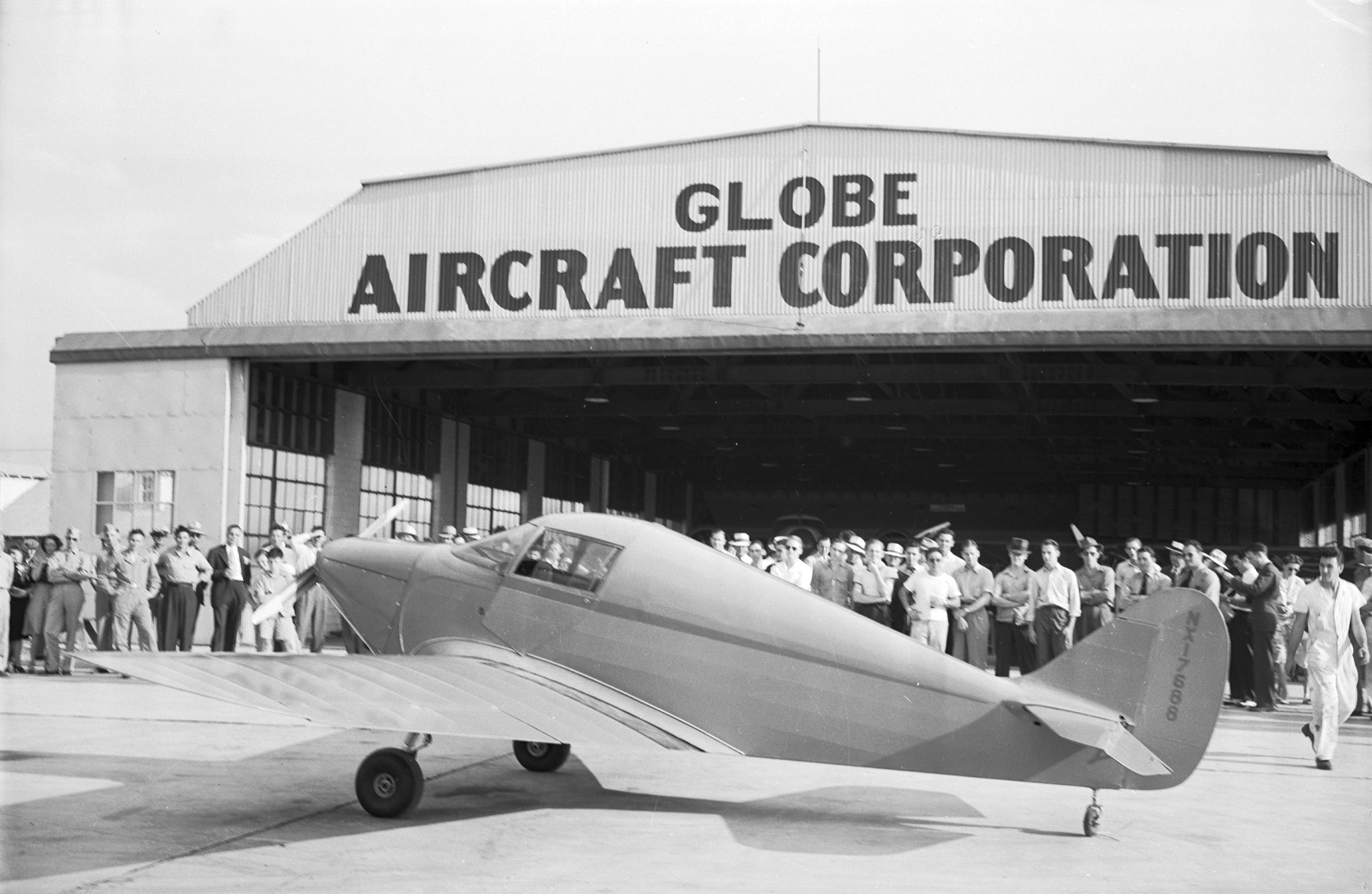
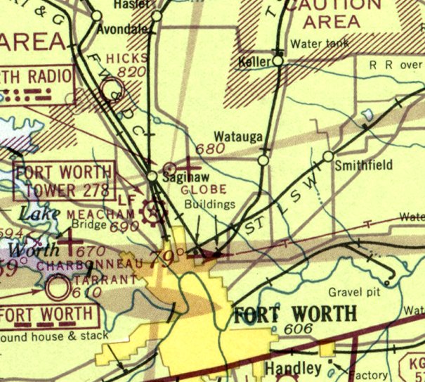
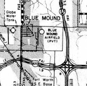
Globe Aircraft Company Factory Airfield / Bell Globe Heliport, Saginaw, TX
32.86, -97.35 (Northwest of Fort Worth, TX)
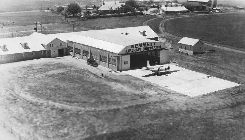
A circa 1941-42 aerial view (from the Swift Museum Foundation, courtesy of Robert Brown)
showing the original Bennett Aircraft Corporation hangar added to John Kennedy's horse stables.
A Bennett BTC-1 is parked in front of the hangar.
This historic aircraft factory & airfield has had a long & convoluted history,
with many different users over the years.
In 1933, John Kennedy (former owner of Globe Laboratories) purchased several hundred acres
near the intersection of Blue Mound & Watauga Roads.
In the next few years Kennedy built facilities on his property for the his intended plans to conduct aircraft manufacturing.
On 4/9/40, John Kennedy established the Bennett Aircraft Corporation of Fort Worth,
along with oilman Frank Bennett & several other investors,
with facilities at Blue Mound Road (according to a report courtesy of Robert Brown).
Their first product was the Bennett BTC-1 twin-engine aircraft,
of which a single prototype had been previously been constructed in California by Frank Bennett.
Their marketing of the aircraft became focused on the military, but it evidently did not see production.
The Bennett Aircraft Company reorganized as the Globe Aircraft Corporation in 1942.
Another source dated the photo 5/26/41, but that appears to be erroneous, as the Globe Aircraft Corporation wasn't incorporated until 1942.
The later end of the timeframe of this photo is set by the fact that the registration of the GC-1 prototype was canceled in 1944.
During WW2, the Globe Aircraft Company conducted licensed production
of 600 Beech AT-10 advanced trainers aircraft at the Saginaw plant.
The dates of Globe's AT-10 production have not been determined,
but the AT-10 was in overall production from 1942-44.
According to Scott Murdock, during WW2 the Globe plant
was designated by the Defense Plant Corporation as Plancor 898,
and the plant property was evidently acquired by the federal government.
The Globe airfield was not depicted on the 1942 Dallas Sectional Chart (according to Chris Kennedy).
The earliest aeronautical chart depiction which has been located of the Globe Airfield was on the February 1943 Dallas Sectional Chart,
which depicted Globe as an auxiliary airfield.
A 10/15/43 aerial view looking north from the 1945 AAF Airfield Directory (courtesy of Scott Murdock)
depicted Globe Airport as having a single north/south runway, with the Globe factory on the northeast side.
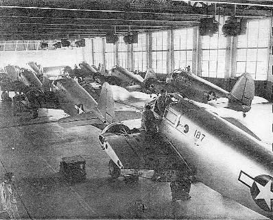
The AT-10 assembly line at Globe's plant.
The Globe plant was declared excess by the Army in 1945,
and sold as surplus in 1946 (presumably back to the Globe company).
After the end of WW2, Kennedy was looking for business to keep his plant humming.
He made a deal with R.S. "Pop" Johnson, who had designed the very first low wing,
2-place retractable gear general aviation aircraft, called "The Swift".
Johnson became an employee of Globe, which would undertake production & marketing of the little aircraft.
The first all-metal Swift flew in 1945, and was certified in 1946.
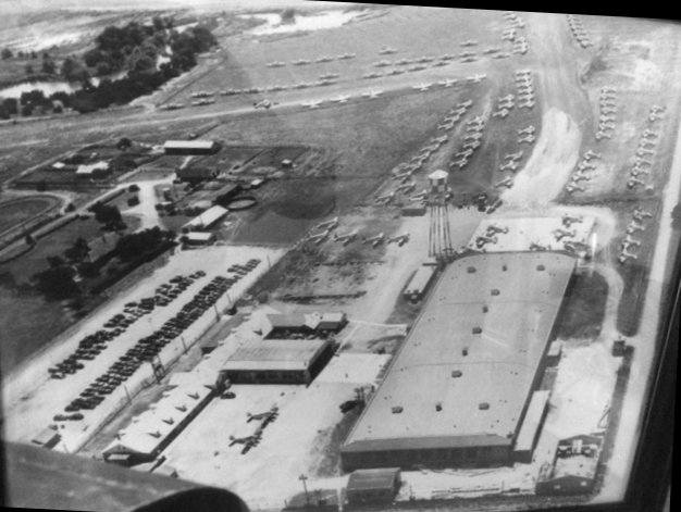
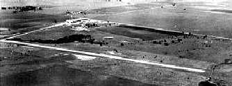
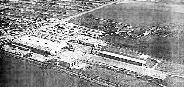
A circa 1940s aerial view looking west at the Globe factory & its airfield (from the Bell archives, courtesy of Wayne Brown),
showing scores of Cessna AT-17 Bobcats being stored.
Wayne Brown reported, “The Globe Airfield... I'm a retired pilot from Bell & did some flying there.
The photo shows Globe with about 120+ twin-engine Cessna Bamboo Bombers parked there.
The picture hung in my boss' office for years & I always wanted a copy because my grandfather owned a Bamboo Bomber.”
A circa 1940s aerial view looking northeast at the Globe factory.
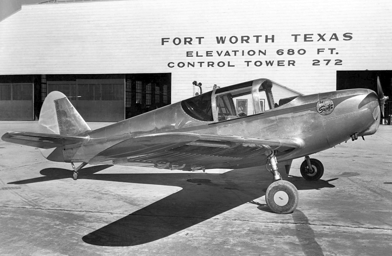
A 1945 photo of all-metal Globe GC-1A Swift NX33336 C/n 2 in front of the Globe Saginaw facility.
Globe worked to continually improve the Swift design, and sales took off.
Returning veterans admired its "hot fighter" look, even though the horsepower of the first run was only 85 hp.
National advertising programs were conducted,
and a tremendous demand & backlog of orders for Swifts resulted.
To meet this backlog of orders, Globe entered into a contract with newly founded TEMCO (Texas Engineering & Manufacturing Company)
at nearby Grand Prairie, TX (at the former North American plant at the Dallas NAS).
The contract authorized TEMCO to build Swifts under sub-contract simultaneously with the Globe production.
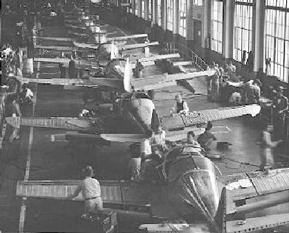
A 1940s view of the Globe Swift production line.
In 1946, Globe & TEMCO together produced a total of 833 Swifts in just over a 6 month period.
Production very quickly caught up with orders,
and suddenly the parking fields near both plants were full of unsold Swifts.
Kennedy soon closed the doors to the Globe Saginaw plant for various business reasons,
but primarily to avoid what we would today call a corporate "hostile takeover".
TEMCO obtained rights to the Swift as payment for money owned them by Globe.
All parts & production tooling for the Swift were transferred to the TEMCO Grand Prairie plant,
and the doors to the Globe Saginaw plant were closed.
Strangely, the Globe factory airfield still wasn't depicted at all on the March 1947 Dallas Sectional Chart (courtesy of Chris Kennedy).
Was it never again depicted as an active fixed-wing airfield?
The Globe Airfield was apparently abandoned for a few years,
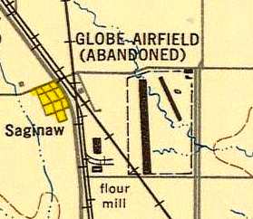
as it was labeled "Abandoned" on the 1948 USAF Urban Area Chart.
It depicted 2 runways: a northwest/southeast strip on the east side, and a longer north/south strip on the west side.
The January 1948 DFW Local Aeronautical Chart (courtesy of John Price) labeled a “plant” at the site, but did not depict an airfield.
A 4/28/48 aerial view looking northeast (courtesy of Jerrell Baley)
depicted a single paved runway in the foreground & the Globe factory in the background.
The next phase of the history of this factory complex concerns its reuse by the Bell Helicopter Company.
When Bell Aircraft moved its growing helicopter manufacturing operations to Fort Worth in 1951,
the Globe Plant in Saginaw was leased by Bell.
All of Bell Helicopter's initial operations, including flight & maintenance training in the Bell 47 helicopter took place at the Saginaw plant.
A variety of design, production, testing & training operations were also conducted by Bell at the old Globe plant.
Bell's Globe operations were also involved in supporting their flight test facility at nearby Hicks Field.
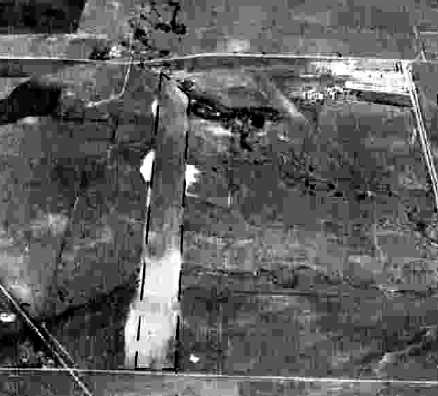
A 4/1/52 USGS aerial view depicted the Globe Airfield as having a single paved north/south runway along the western side.
There were no aircraft visible on the field.
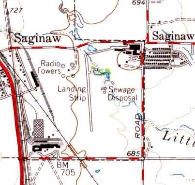
A single runway was depicted at the Globe Airfield on the 1955 USGS topo map, labeled simply as “Landing Strip”,
along with the factory buildings.
A 1957 aerial view depicted the Globe Airfield as having a single paved north/south runway along the western side.
There were no aircraft visible on the field.

The August 1962 Dallas Local Aeronautical Chart depicted Bell Globe as a private heliport.
A single north/south runway was depicted at the Globe facility
on the 1963 Tarrant County TX Highway Department Map (courtesy of Gainey Bradfield).
It was listed as the "Bell Globe" Heliport in the 1963 TX Airport Directory (courtesy of Steve Cruse),
and described as having a 3,000' x 100' landing area.
A 1963 aerial view depicted the Globe Airfield as having a single paved north/south runway along the western side.
There were no aircraft visible on the field.
The 1964 DFW Local Aeronautical Chart (courtesy of John Price) depicted "Bell Globe" as a private heliport.
In a 1970 aerial view of Globe Airfield, the western runway was prominently marked with several closed “X” symbols,
and there was no sign of the former eastern runway.
A large hangar had been built (for helicopters?) on the northwest corner of the field at some point between 1948-70.
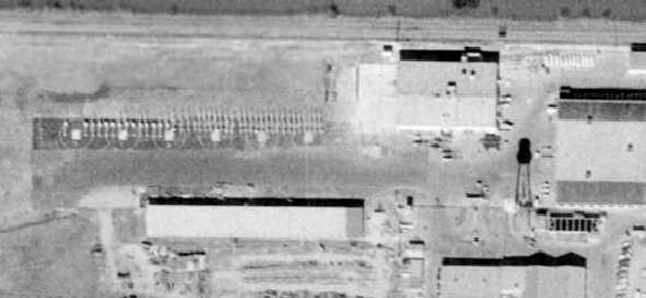
A closeup from the 1970 aerial photo of the ramp next to the Globe factory showed what appeared to be a large number of light helicopters (Bell 47s?).
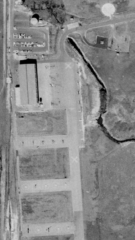
A closeup from the 1970 aerial photo of the Globe airfield's northwest ramp, which was expanded at some point between 1963-70,
showing the hangar & a dozen unidentified helicopters.
These 1970 photos are the last photos to be located showing aircraft on this historic airfield.
Bell Helicopter's pilot & maintenance training continued at the Globe Plant until 1970,
when those activities were shifted to new facilities in Hurst, just southwest of their main plant.
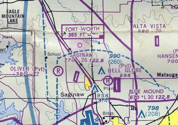
The July 1976 DFW Terminal Chart (courtesy of Jim Hackman) still depicted “Bell Globe” as a private heliport.
A 1979 aerial view did not show any aircraft on the field.
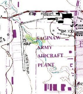
In the 1981 USGS topo map, the property was still labeled "Saginaw Army Aircraft Plant".
It depicted a single 2,200' paved north/south runway on the west side, and a heliport on the east side.
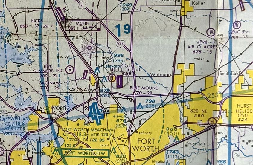
The last aeronautical chart depiction which has been located of the Bell Globe Heliport was on the June 1988 Dallas Terminal Chart (courtesy of Ken Mercer).
A 1990 aerial view showed the Globe airfield to be abandoned, with not a single aircraft or helicopter visible on the property.
The Bell Globe Heliport was evidently closed at some point between 1988-93,
as it was no longer depicted on the 1993 DFW Terminal Aeronautical Chart (courtesy of Jonathan Westerling).
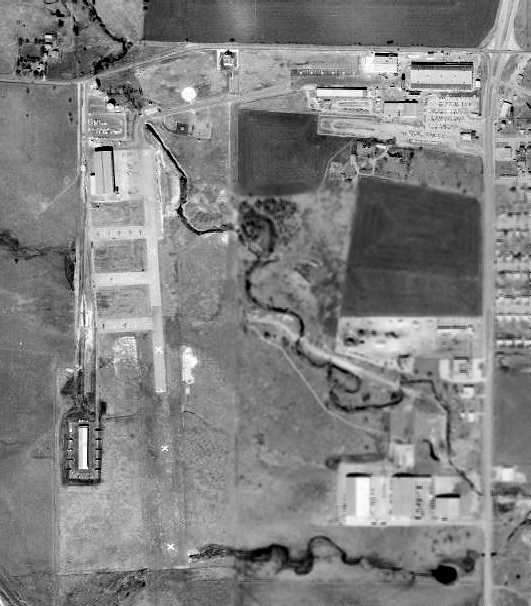
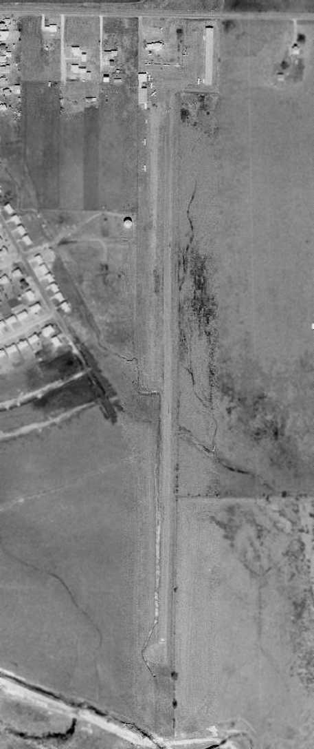
A 1995 USGS aerial view looking south at the Globe Airfield, the paved runway on the western side was intact though deteriorated.
A 2001 photo of the interior of the Globe factory building.
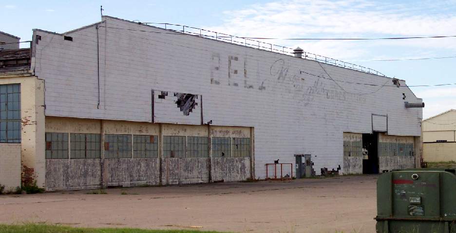
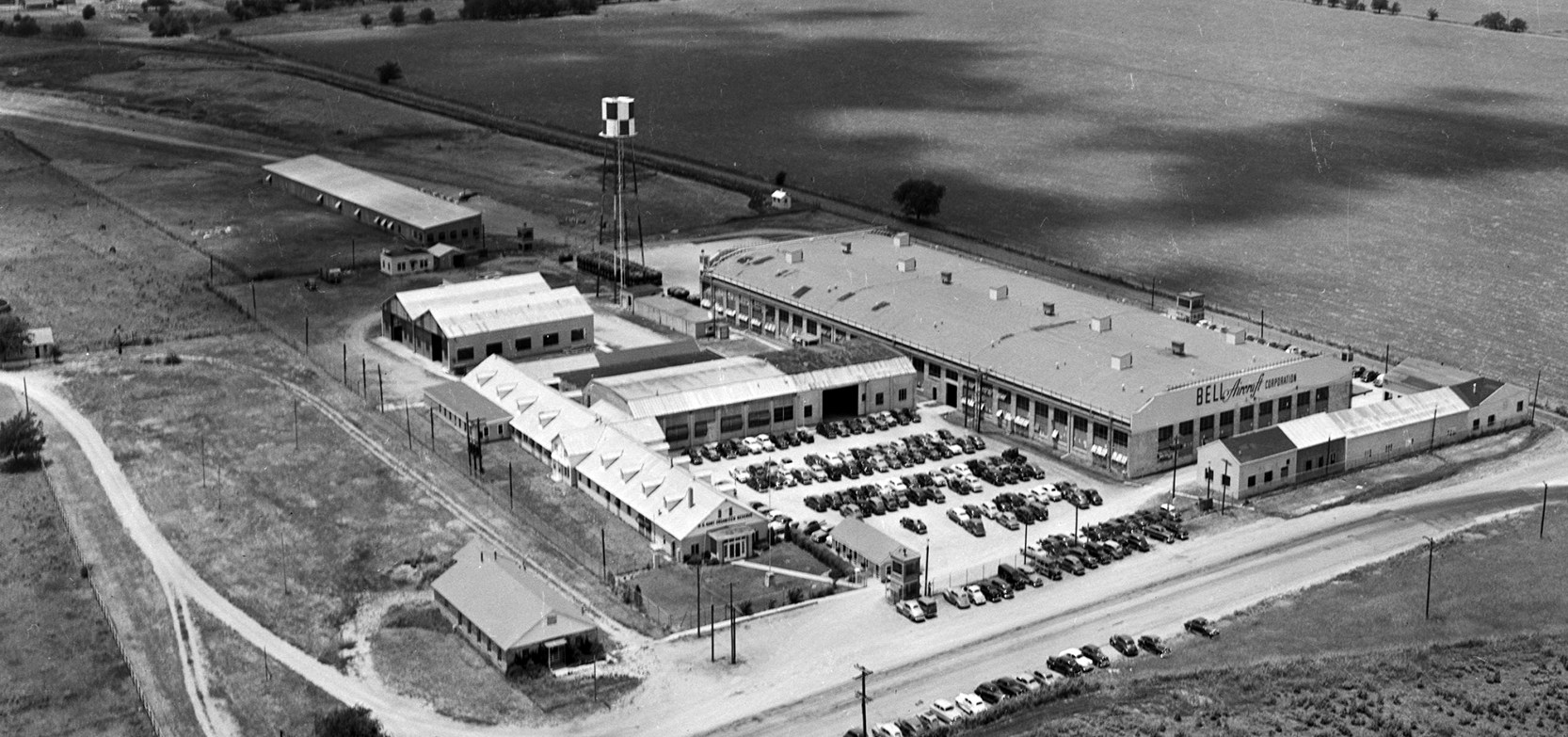
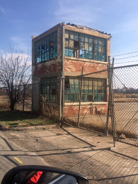
A 7/02 photo by Paul Freeman of the west side of the abandoned Globe factory building,
showing the "Bell Helicopter" lettering which was still plainly discernible.
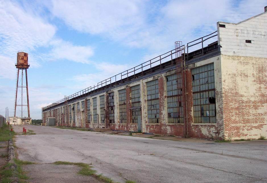
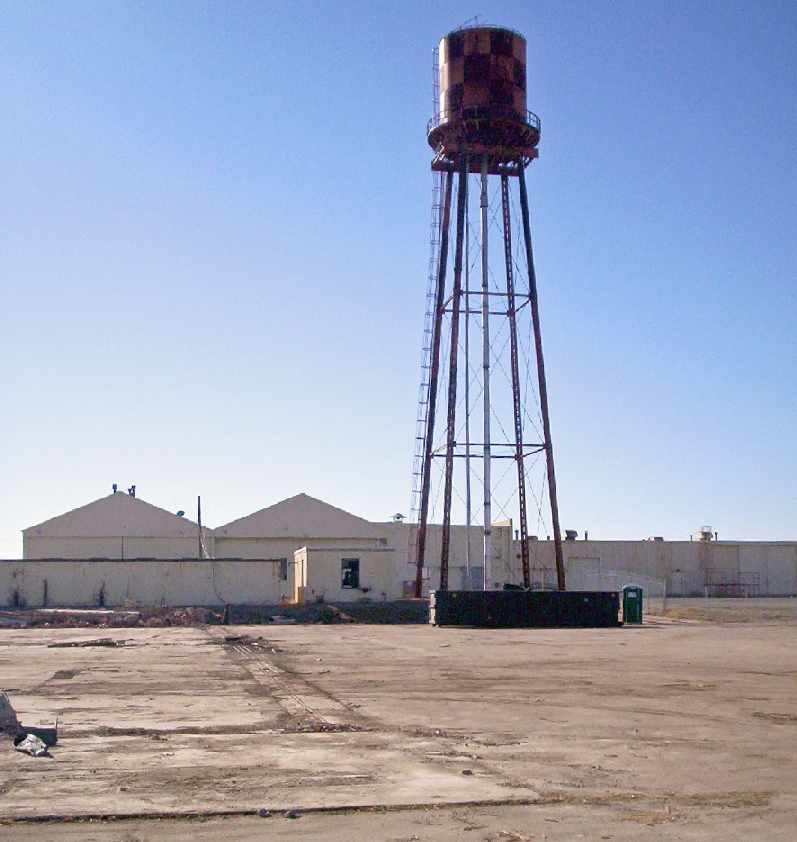
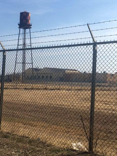
A 7/02 photo by Paul Freeman, looking east along the north side of the Globe factory, with the airfield water tower in the background.
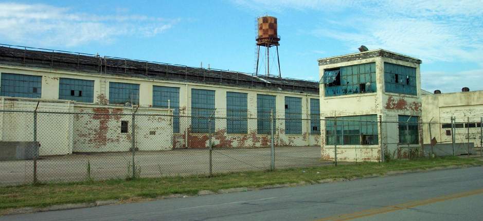
A 7/02 photo by Paul Freeman of the south side of the Globe factory, along with its security tower.
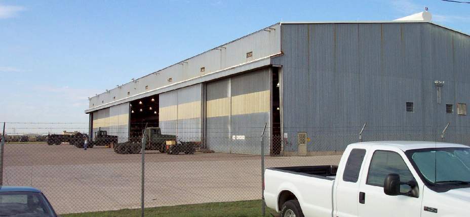
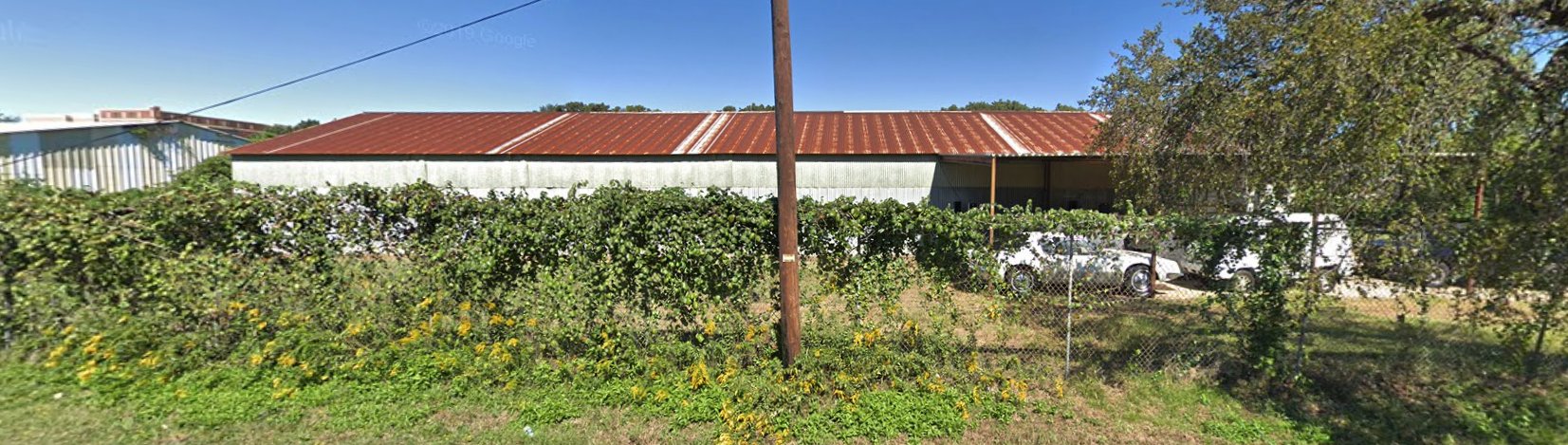
A 7/02 photo by Paul Freeman of a former hangar on the west side of the former Globe airfield,
which appears to be of somewhat more recent construction than the others on the property.
The hangar is now used to overhaul military trucks.
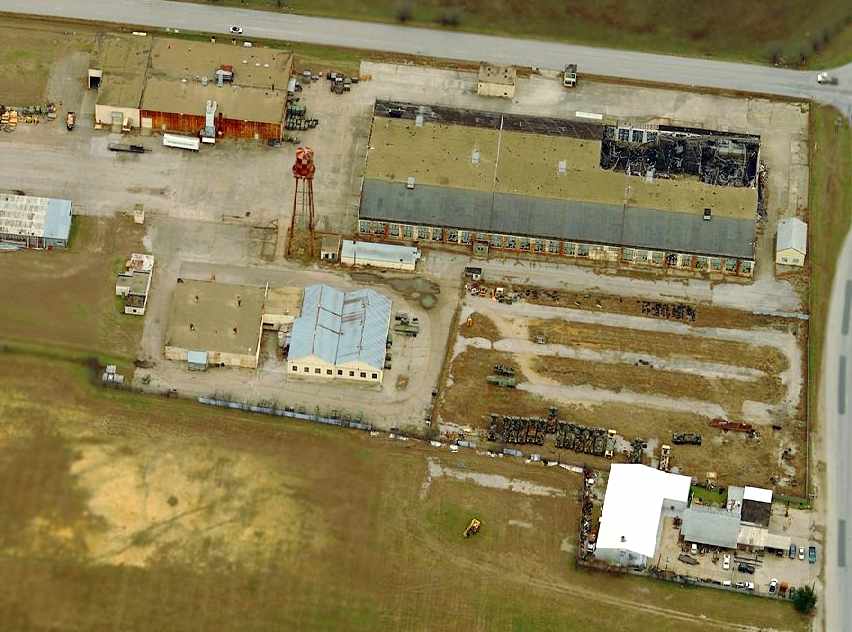
Paul Freeman visited the site of the Globe plant in 2002.
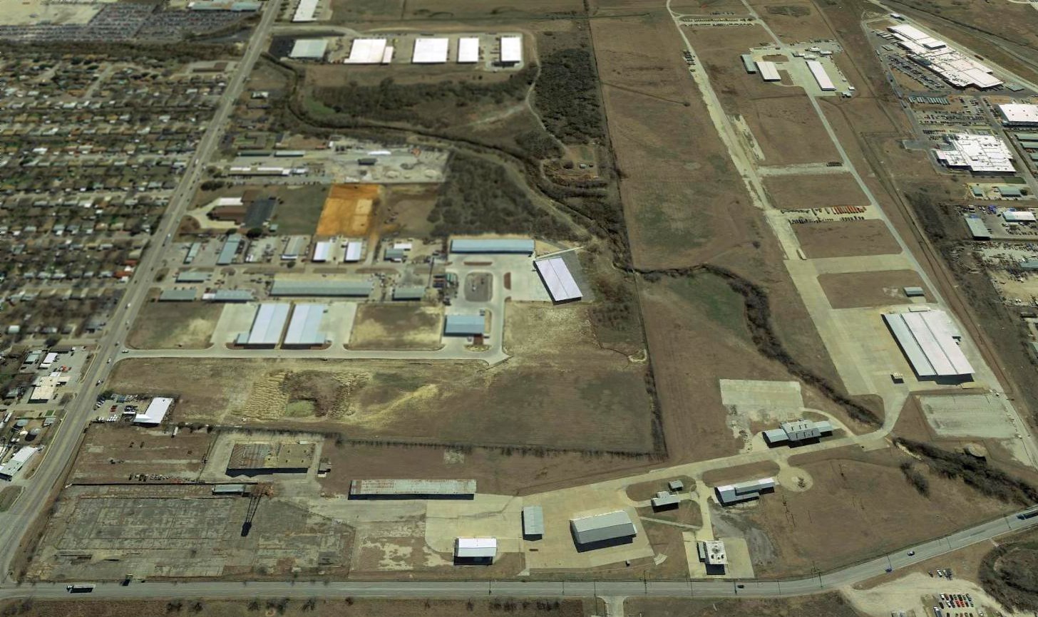
At the northeast corner of the property, all of the original Globe factory buildings still stand,
although in very decayed condition.
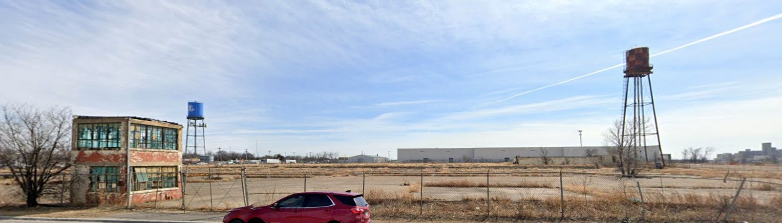
The factory's water tower still stands to the south of the plant,
still painted in the red & white checkerboard pattern commonly found at airfields.
A paved taxiway leads west from the factory buildings toward the paved runway, which also still exists.
A former hangar sits along the west side of the runway.
The hangar is of noticeably later construction than the factory buildings,
presumably built at some point by Bell Helicopter during their tenure at the Globe plant.
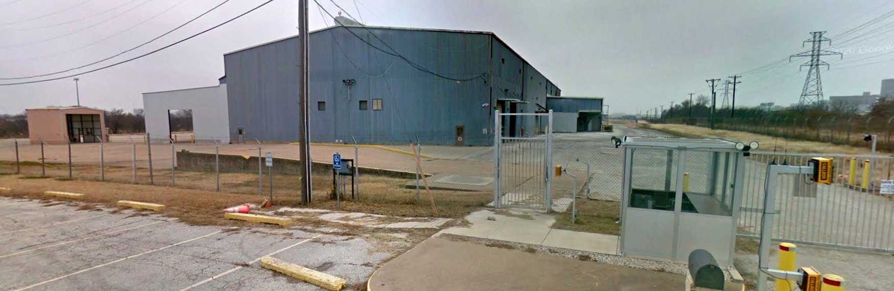
The entire complex is surrounded by a high barbed-wire fence,
and it apparently reused by a company which overhauls military cargo trucks.
The runway is used as a parking area for a large number of these trucks.
Scott Murdock visited the Globe plant in 2004, and reported that the property remains basically unchanged.
Tim Tyler reported in 2004 that a portion of the "former Saginaw Army Aircraft Plant" was listed for sale
in an online auction by the General Services Administration.
The parcel listed for sale was a total of almost 7 acres,
and included several buildings, including an Aircraft Manufacturing Building
(93,606 square feet, of which a portion of the roof was described as having collapsed),
a Facility Maintenance Shop, Guard House (North), Covered Reservoir, Pump House, Elevated Water Storage Tank,
Guard House (South), Aircraft Paint Shop, Water Well, Fire House Station, and a parking lot.
Scott Murdock visited the site of Globe Aircraft in 2005, and it looked largely unchanged from its appearance in 2002.
A circa 2002-2005 aerial view looking north at the former Globe Factory,
showing that the northeast end of the factory was already partially demolished.
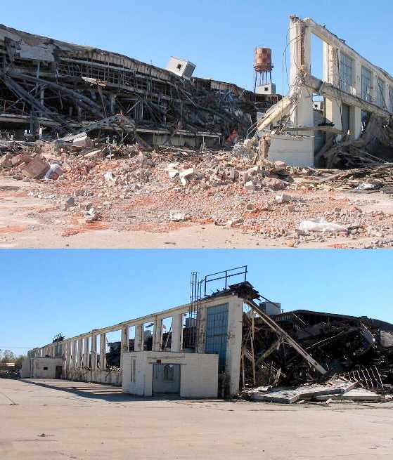
Unfortunately the end came for the historic Globe factory building in 2005,
as shown by these 2 pictures (courtesy of Mike Headley).
Mike observed later in 2005, “The only difference between these photos & what the site currently looks like
is that the remaining portions of the building have been knocked down completely.
It's really sad that this building that I've grown up around is gone.
It took my breath away when I saw what had happened a few days ago.
I am not sure what the fate of the remaining buildings are
but there is heavy equipment still parked on the property
and it's still possible that the rest will be demolished in the coming days.”
A 12/15/05 photo by Mark Nemier, showing the tracks coming out of the west end of the former hangar.
A 12/15/05 photo by Mark Nemier, showing the unfortunate state of the former Globe factory.
LTC Brian Michel, Superintendent of the Saginaw National Guard facility, reported in 2014, “From time to time members of the Globe Swift museum stop by
and the last time they visited they departed with the old windsock stand. It is now flying a sock outside the museum.”
A December 2016 photo looking south at a former hangar on the west side of the former Globe airfield, at one point used by the National Guard, now appearing abandoned.
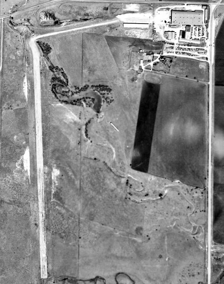
A 1/25/17 aerial view looking south at the Globe Airfield showed the paved runway on the western side was intact,
but the entire Globe factory building had been removed.
A 2/5/17 photo by Matt Franklin of the former Globe factory security building.
Matt reported, “There is a big for sale sign next to the security hut.
I wouldn't want to venture beyond the fence as it looks like it is a National Guard Armory, given the entrance on the other side's signage.”
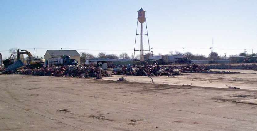
A 2/5/17 photo by Matt Franklin of the former Globe factory water tower.
A March 2022 photo looking south at all that remains of the Globe aircraft factory: its guard building & water tower.
The Globe factory & airfield site is located southwest of the intersection of Blue Mound Road & East McLeroy Road.
The southern edge of the property is bounded by Kennedy Lane
(evidently named for the former President of Globe Aircraft Company).
Another clue to the area's aviation heritage may be found on the opposite (east) side of Blue Mound Road,
where sits a small community of vintage small single-family homes,
evidently built as the factory housing for the workers of the Globe plant.
The neighborhood has streets named Globe Avenue, Bell Avenue, Continental Street, etc.
See also:
http://www.bellhelicopter.textron.com/content/training/about/history.htm
http://www.napanet.net/~arbeau/swift/gplant2.htm
____________________________________________________
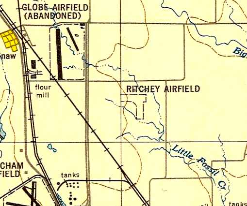
32.84, -97.33 (Northwest of Fort Worth, TX)
Ritchey Field, as depicted on the August 1944 Dallas Sectional Chart (courtesy of David Brooks).
Photo of the airfield while open has not been located.
Ritchey Field was evidently established in 1944, as it was not yet depicted on the March 1944 Dallas Sectional Chart.
The earliest depiction of Ritchey Field which has been located
was on the August 1944 Dallas Sectional Chart (courtesy of David Brooks), which depicted it as an auxiliary airfield.
Camilla Ritchey recalled, “Ritchey Field... That was our property.
It had a large Quonset-hut type hangar that held 2 airplanes & had workshops on either side.
The field opened in 1944. My father, Ed Ritchey, used it for touch & go training with his flight students.
It was mostly his private airfield; I rarely saw other pilots use it.”
The January 1948 DFW Local Aeronautical Chart (courtesy of John Price) depicted Ritchey Field as having a 2,500' unpaved runway.
The 1948 USAF Urban Area Chart (courtesy of David Brooks)
depicted "Ritchey Airfield" simply as an outline, with a 1,600' east/west runway & a 1,400' north/south runway.
No buildings were depicted.
The earliest photo which has been located of Ritchey Field was a 4/10/52 USGS aerial view.
It depicted 2 hangars on the east side of 2 grass runways.
Ritchey Field may have gone through a period of closure for a few years,
as the 1955 USGS topo map depicted its 2 small buildings but without any airport label.
The August 1962 Dallas Local Aeronautical Chart depicted Ritchey as a private airfield having a 2,500' runway.
Ritchey Field was not depicted at all on the 1963 Tarrant County TX Highway Department Map (courtesy of Gainey Bradfield).
The 1963 TX Airport Directory (courtesy of Steve Cruse) described Ritchey Field as having a 2,500' sod runway.
The manager was listed as Edwin Ritchey, of the Ritchey Flying Service.
Fred Fischer recalled, "Ritchey 'International' was the residence of Ed Ritchey
who owned a flying, maintenance and P & W overhaul service at Meacham.
He also had a rather nice, large hangar at his place."
The 1964 DFW Local Aeronautical Chart (courtesy of John Price)
depicted Ritchey as a private airfield having a 3,000' unpaved runway.
Camilla Ritchey recalled, “Ritchey Field... stopped being functional when he [Ed Ritchey] sold the land in 1965.”
According to David Brooks, "I suspect it was abandoned when they put the Interstate 820 bypass in
as it took a hunk of the land."
Ritchey Field was no longer listed in the 1967 TX Airport Directory (courtesy of Brad Stanford).

The last aeronautical chart depiction which has been located of Ritchey Field was on the February 1968 Dallas Sectional Chart.
It depicted Ritchey as a private airfield having a 3,000' unpaved runway.
Ritchey Field was no longer depicted on the July 1968 Dallas Sectional Chart.
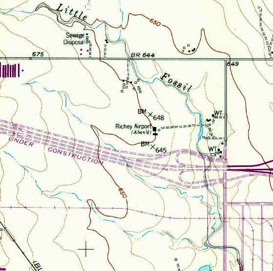
The only topo map depiction which has been located of Ritchey Field was on the 1969 USGS topo map,
which depicted “Richey Airport (Aban'd)” (sic) as having 2 small buildings.
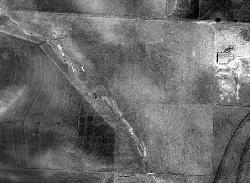
A 1970 aerial view of the site of Ritchey Field, showing the hangar in the center of the property,
and the highway which cut across the southern portion of the airfield.
A closeup from the 1970 aerial view showing the former Ritchey Field hangar which remained standing.
A 1979 aerial photo showed that the former Ritchey Field hangar had been removed at some point between 1970-79.
The outline of the former Ritchey Field, superimposed by David Brooks over the 1995 USGS aerial photo.
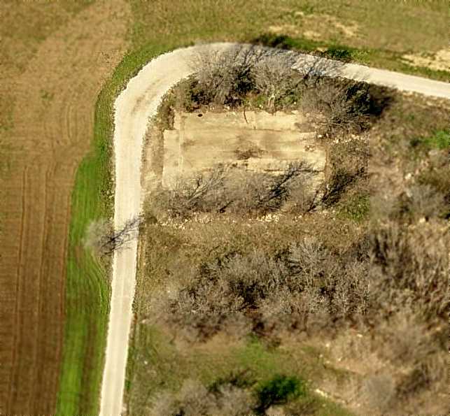
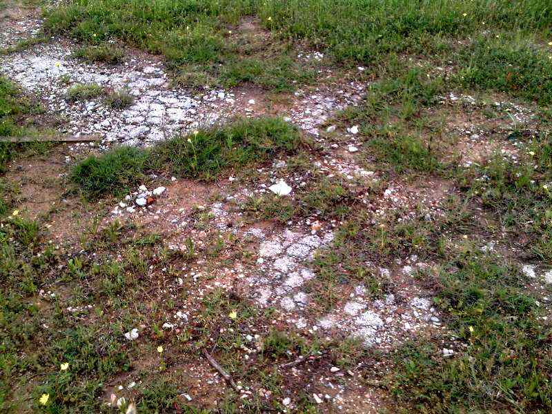
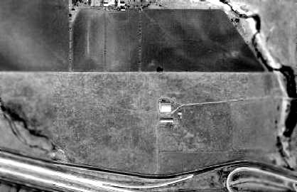
A circa 2006 aerial view looking north at the last remains of Ritchey Field – the concrete slab floor of the hangar.
The site of Ritchey Field is located east of the intersection of the Interstate 820 Bypass & Blue Mound Road.
____________________________________________________
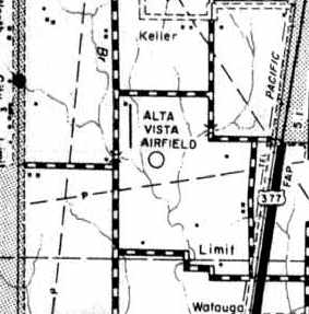
Alta Vista Airport (28F), Keller, TX
32.898, -97.288 (Northwest of Fort Worth, TX)
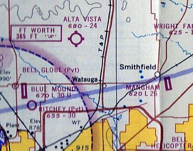
Alta Vista Airfield, as depicted on the August 1962 DFW Local Aeronautical Chart.
This small general aviation airfield was apparently built at some point between 1961-62,
as it was not yet depicted on a 1956 aerial photo or the March 1961 Dallas Sectional Chart.
The earliest depiction which has been located of Alta Vista Airfield was on the August 1962 DFW Local Aeronautical Chart.
It depicted Alta Vista as a private airfield having a 2,600' unpaved runway.
The 1962 AOPA Airport Directory described Alta Vista as having a 2,750' sod Runway 18/36,
but included the caution, "Emergency use only".
The earliest photo which has been located of Alta Vista Airfield was a 1963 aerial photo.
It depicted the field as having a single grass north/south runway,
with a small hangar & 4 single-engine aircraft on the north end.
Alta Vista Airfield, as depicted on the 1963 Tarrant County TX Highway Department Map (courtesy of Gainey Bradfield).
The 1963 TX Airport Directory (courtesy of Steve Cruse) described Alta Vista in much the same as the 1962 AOPA Directory,
and listed the manager as Ronald Cheek.
Alta Vista Airport, as depicted on the 1965 Enco Oil DFW road map.
The earliest photo which is available of Alta Vista Airport was a 9/19/68 USGS aerial photo.
It depicted the field as having a single grass north/south runway,
with a small hangar & 4 single-engine aircraft on the north end.
The runway had apparently been slightly shortened by 1970,
as the 1970 TX Airport Directory (courtesy of Ray Brindle) described the runway configuration as a single 2,465' turf Runway 17/35.
A single hangar was depicted west of the north end of the runway.
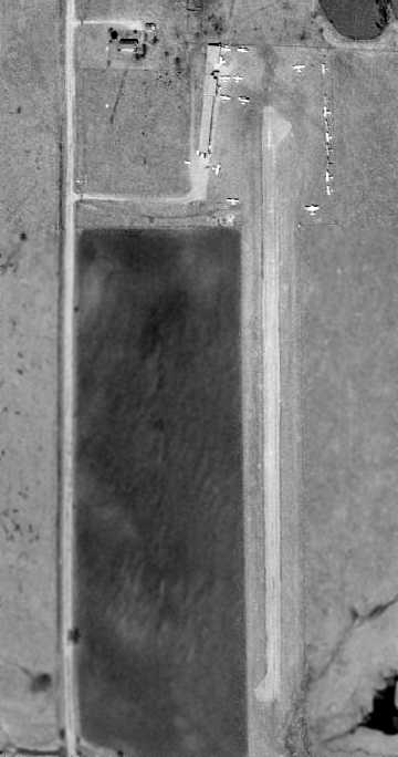
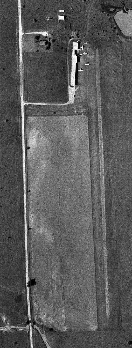
Alta Vista gained a paved runway at some point in 1970, as a 1970 aerial view depicted the field as having a single paved north/south runway.
A hangar sat at the northwest corner of the field, around which were parked 20 single-engine aircraft.
The 1973 DFW Sectional Chart (courtesy of Robert Brown) depicted Alta Vista as having a single 2,000' asphalt runway.
Mark McCauley recalled, “I flew in & out of the old Alta Vista once with a neighbor who had a Skymaster there.”
Don Tedrow recalled of Alta Vista, "I got my Multi-engine rating there in 1974, and helped around the shop there a bit.”
The July 1976 DFW Terminal Chart (courtesy of Jim Hackman) depicted Alta Vista as having a 2,000' paved runway.
Don Tedrow recalled of Alta Vista, "I finished my Commercial & Instrument ratings there in 1977 with M.J. (Merle) Simpson.
My last logged flight out of there was in December 1978."
Alta Vista's runway was apparently somewhat lengthened by 1978, as the 1978 TX Airport Directory (courtesy of Chris Kennedy)
depicted Alta Vista as having a single 2,500' asphalt Runway 17/35.
Two hangars were located on either side of the north end of the runway. The manager was listed as M. J. Simpson.
A 1979 aerial photo showed only a single aircraft on Alta Vista Field.
Don Tedrow recalled, "Sometime around 1979 I believe, Mr. Simpson passed away, but his Widow continued to sell fuel & rent hangars for another 18 months or so.
At that time, her lease on the property expired."
USGS topo map 1981.
The 1982 AOPA Airport Directory still listed Alta Vista Airport,
and gave the runway configuration as a single 1,980' asphalt Runway 17/35, but included the remark, "Private. Use at own risk."
The last aeronautical chart depiction which has been located of Alta Vista Airport was on the January 1984 Dallas Sectional Chart.
It depicted Alta Vista as having a 2,000' paved runway.
Don Tedrow recalled, "Mr. & Mrs. Simpson as I recall had leased the land for 20 years in the early 1960s,
and had built the runway & most of the structures.
When time drew near for the end of the lease, the property was purchased by a judge & 2 other partners.
A dispute then arose regarding the terms of the lease.
Mrs. Simpson asked for a little compensation for the improvements made to the property (runway, hangars, etc.)
since her lease made no mention that any improvements automatically reverted to the new owners.
Her lease only required that she leave the property in 'clean & level condition'.
The judge & his partners wouldn't pay anything, so Mrs. Simpson sold the hangers & some other equipment, which was dismantled & trucked away.
Then, during the last few days of the lease, some old friends of Mr. Simpson helped his widow plow the asphalt runway up & haul it away,
in a bit of 'justice' for the judge having snubbed & harassed Mrs. Simpson, a women of very modest means.
I heard that later, the judge's 2 partners were thinking of suing him for having so mis-managed the affair,
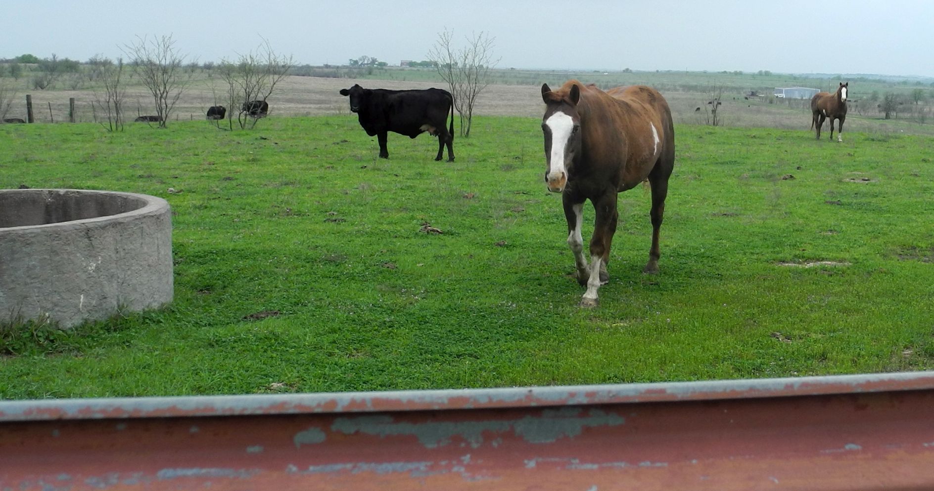
their nice little country airport having reverted to just another cow pasture."
Alta Vista Airport was no longer depicted on the January 1988 Dallas Sectional Chart.
A 1990 aerial view showed the outline of the former runway (with the pavement having been removed, as described above),
and the foundation of the hangar.
A 1995 USGS aerial view looking southeast showed the outline of Alta Vista Airport's runway was still perceptible, along with hangar foundations.
A 2001 USGS aerial photo of the Alta Vista Airport site showed that a new housing development had covered the northern portion of the former airfield.
Shawn Carver reported in 2003, "This site very near where I live.
The site lies between a fairly new housing development at the corner of North Beach Street & Shiver Road,
and a new section of North Tarrant Parkway which is just to the south.
Neither the housing development nor the new section of North Tarrant Parkway appear in the [above 1995] aerial photo.
The portion of the southern end of the airfield site has already been obliterated by construction of a (big surprise!) - a Wal-Mart Supercenter.
However, much of the northern portion of the airfield site has not yet been developed.
I parked my car on the side of North Beach, and took a walk through the open field toward the area
where you can clearly make out the outline of runway & a widened ramp/parking area in the aerial photo.
The field consists of mostly grass & mesquite trees.
On the ground, it was hard to tell that anything had been there before,
but it was pretty clear that there had been a driveway of some sort leading into the field from North Beach Street."
Shawn continued, "There is also not much evidence that a runway had ever existed there, but I did find a few chunks of very old asphalt.
After walking around for a little while, I stumbled upon a couple of things that just screamed at me saying 'There was an airfield here!'.
Lying on the ground, partially buried, was an instrument panel from an airplane!
I am unable to identify the type of airplane the panel came from, but it is a very simple panel.
All of the few instruments it once had are missing or rusted out, but there is a large magneto switch right in the middle of it.
Right next to the panel, lying on its side, is a small rusty barrel filled with concrete & a tie-down ring in the center.
It has been dug up out of the ground at some point. There is a chain still attached to the tie-down ring.
I don't think the remains of this airfield will last much longer. The area is rapidly being transformed by development."
Kirk Blackwelder reported in 2004 that his new house sits only a mile from the site of Alta Vista Airport.
He visited the airport site, and reported: "I was able to find the 'instrument panel' Shawn Carver found last year.
I can confirm that it was very simple, but I'm perplexed as to what type of aircraft it might have come from.
The only recognizable instrument was switch reading 'Ignition', which displayed 'L', 'R', and 'Both'.
I assumed it was a magneto indicator as well. This may not have been from an aircraft at all... perhaps a maintenance trainer?"
A 2016 aerial view looking southeast showed no trace remaining of Alta Vista Airport.
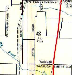
The site of Alta Vista Airport is located southeast of the intersection of North Beech Street & Shiver Road.
____________________________________________________
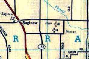
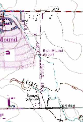
Pops Field / Blue Mound Airport (3F0), Blue Mound, TX
32.86, -97.33 (Northwest of Fort Worth, TX)
Pops Field, as depicted on a 4/1/52 USGS aerial view.
Located less than a mile to the east of the former Globe Factory Airfield is the site of another airfield - originally known as Pops Field.
Pops Field was apparently built at some point between 1950-52,
as it was not depicted on the February 1950 Dallas Sectional Chart.
The earliest depiction which has been located of Pops Field was a 4/1/52 USGS aerial view.
It depicted Pops as having an unpaved north/south runway,
with some small buildings & 1 light single-engine plane on the north side.
The earliest aeronautical chart depiction which has been located of Pops Field was on the August 1952 Dallas Sectional Chart.
It depicted Pops as having an 1,800' unpaved runway.
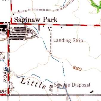
Pops Field was depicted as a single unpaved north/south runway on the 1955 USGS topo map, labeled simply as “Landing Strip”,
along with a few small buildings on the north side of the field.
A 1957 aerial photo depicted Pops Field as having a single unpaved north/south runway, with a hangar at the north end.
No aircraft were visible on the field.
Pops Field, as depicted on a 1960 Humble Oil DFW road map.
The August 1962 Dallas Local Aeronautical Chart depicted Pops as a private airfield having an 1,800' runway.
Fred Fischer recalled, "It was owned by & named for 'Pop' Popolawski, an excellent & renowned aircraft painter.
I first landed there in 1962. At that time the runway, as I recall, was approximately 1,200' grassy sod.
I had just flown a Cessna 310 in from Abilene to have it painted."
The 1963 Tarrant County TX Highway Department Map (courtesy of Gainey Bradfield)
depicted the field as “Blue Mound Airfield (Private).
A 1963 aerial photo depicted Blue Mound as having a single unpaved north/south runway, with a hangar at the north end.
No aircraft were visible on the field.
The 1964 DFW Local Aeronautical Chart (courtesy of John Price)
depicted Blue Mound as a public-use airport with a 3,000' paved runway.
Fred Fischer recalled, "In late 1964, Pop sold the field to Tom Baker & Associates (3 dentists)
and moved his paint operation to Cleburne Municipal.
In September 1964, I had just quit Bell Helicopter as a Technical Representative.
In anticipation of Part 135, Tom Baker approached me
and in 1965 I established a Part 135 Air Taxi & a Part 141 Flight School at Blue Mound.
The old sod runway became our parking/tie down area
and an entirely new long, paved & lighted runway was built immediately adjacent to the east.
Hangars were built to the east at the north end."
George Ott recalled, “Blue Mound Airport... I used to fly DC-3s out of there, also Convair 440s.
Pulse West Lain had an Airframe & Powerplant [mechanic] school there.”
A 1970 aerial view depicted Blue Mound as having a single paved north/south runway, with a row of T-hangars on the northwest & northeast side.
The little airport was perhaps at the zenith of its popularity, with 10 single-engine aircraft seen parked on the north end.
The 1970 TX Airport Directory (courtesy of Ray Brindle) depicted Blue Mound as having a 3,050' asphalt Runway 17/35.
A row of T-hangars was located east of the north end of the runway,
and an office & another hangar were west of the north end of the runway.
Mel Asberry recalled, “In 1972, I flew my Mooney from Seagoville Airport to Blue Mound every Thursday evening to attend Wes Lane’s A&P school.”
The last aeronautical chart depiction which has been located of Blue Mound Airport was on the July 1976 DFW Terminal Chart (courtesy of Jim Hackman),
which depicted Blue Mound as having a 3,000' paved runway.
A 1979 aerial photo depicted 7 light aircraft on Blue Mound Airport.
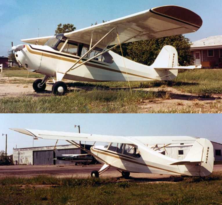
A late 1979 or early 1980 of Mark McCauley in his father's Bonanza at Blue Mound Airport.
Mark reported the photo was “looking north/northeast, the hangar being parallel to & east of the runway.
In the late 1979 & early 1980 I learned to fly from there when my father (Lyn McCauley) purchased a Bonanza that we kept there.
I knew William (Bill) Casey, Sr. & his son Jr. who had an Aero Commander dealership there.”
The last photos which are available showing Blue Mound Airport in operation
was two October 1980 photos of an Aeronca Champ at Blue Mound Airport (courtesy of Zane Adams).
The 1981 USGS topo map depicted Blue Mound Airport as having a single north/south runway.
The last photo which has been located showing aircraft at Blue Mound Airport was a 1981 aerial view,
which showed 1 light single-engine aircraft on the field.
The 1982 AOPA Airport Directory (courtesy of Ed Drury)
described Blue Mound Airport in a similar manner as that described in the 1970 directory.
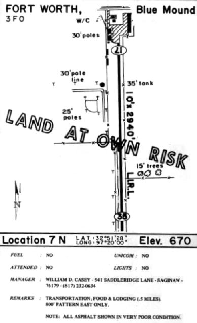
By 1985, Blue Mound's runway had already deteriorated,
as the entry in the 1985 TX Airport Directory (courtesy of Steve Cruse) included the note
"All asphalt shown in very poor condition", and the diagram was superimposed with a "Land at own risk" warning.
A number of small hangars were shown at the north end of the runway, along what was at the time Watauga Smithfield Road.
The manager was listed as William Casey.
Blue Mound Airport apparently closed (for reasons unknown) at some point between 1985-90,
as a 1990 aerial view showed that the hangars had been removed, and there were no aircraft on the field.
The runway remained intact, though somewhat deteriorated.
Blue Mound Airport was no longer depicted on the 1993 DFW Terminal Chart (courtesy of Jonathan Westerling).
A 1995 USGS aerial view looking southwest showed the former Blue Mound Airport runway remained recognizable.
Paul Freeman visited the Blue Mount Airport site in 2002.
The Blue Mound City Park bordered the west side of the former airfield property, along Globe Avenue.
Not a trace of the former airport could still be perceived -
the former airport property appeared to be simply an empty grass field.
A 2005 photo by Mark Nemier, “Looking south from north end of the original field, near Western Center.
The road that now sits on where the north end of the runway was is called Mark IV Parkway.
What was left is now plowed under as development creeps in.”
A 2005 photo by Mark Nemier, “Looking south from mid-field, with roads being laid in.
Note the skyline of downtown Forth Worth in the background.”
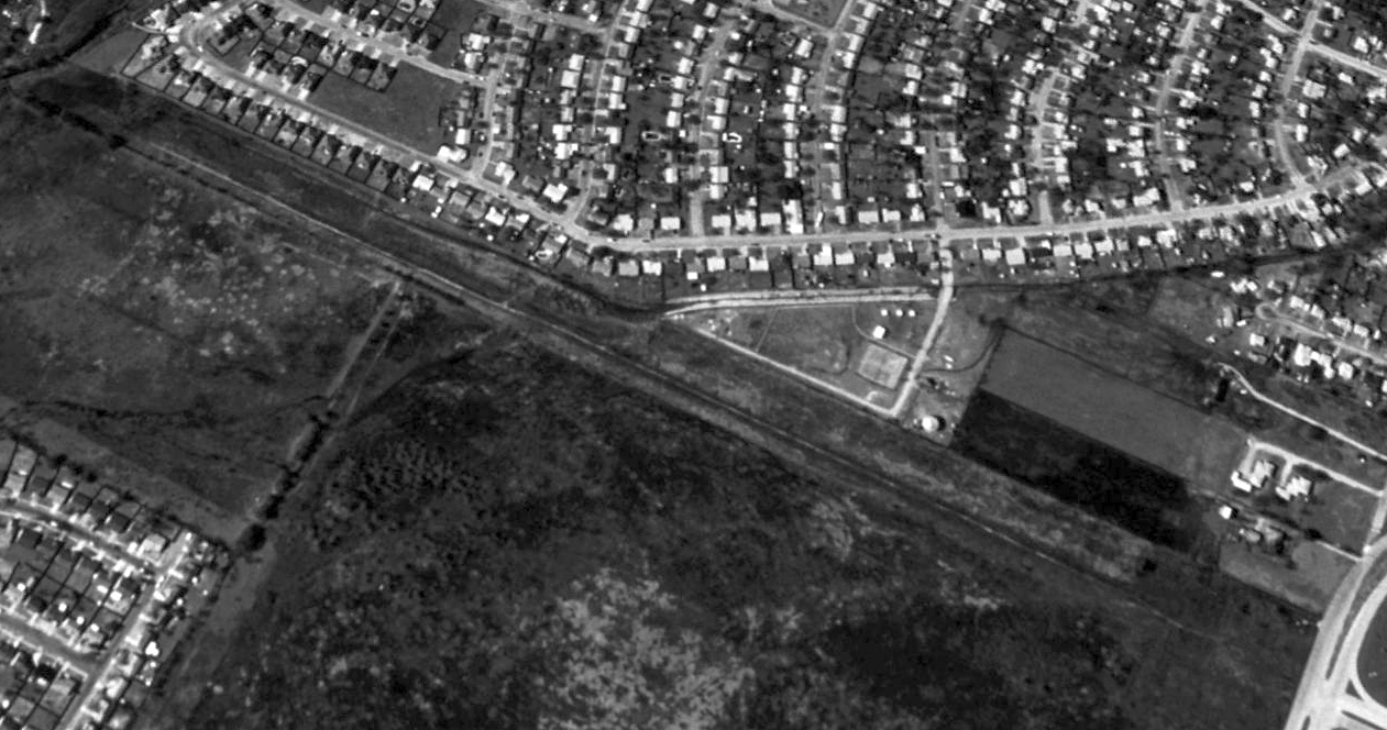
Even though houses have been built in dense fashion all around, a 2019 aerial view looking southwest shows the alignment of the former Blue Mound Airport runway remained mostly clear & recognizable.
The site of Blue Mound Airport is located south of Western Center Blvd, a half mile east of Blue Mound Road.
____________________________________________________
Since this site was first put on the web in 1999, its popularity has grown tremendously.
If the total quantity of material on this site is to continue to grow,
it will require ever-increasing funding to pay its expenses.
Therefore, I request financial contributions from site visitors,
to help defray the increasing costs of the site
and ensure that it continues to be available & to grow.
What would you pay for a good aviation magazine, or a good aviation book?
Please consider a donation of an equivalent amount, at the least.
This site is not supported by commercial advertising –
it is purely supported by donations.
If you enjoy the site, and would like to make a financial contribution,
you
may use a credit card via
![]() :
:
Please consider checking the box to make a monthly donatation.
For a mailing address to send a check, please contact me at: paulandterryfreeman@gmail.com
If you enjoy this web site, please support it with a financial contribution.
please contact me at: paulandterryfreeman@gmail.com
If you enjoy this web site, please support it with a financial contribution.
Or if you prefer to contact me directly concerning a contribution (for a mailing address to send a check),
please contact me at: paulandterryfreeman@gmail.com
If you enjoy this web site, please support it with a financial contribution.
____________________________________________________
This site covers airfields in all 50 states.