Abandoned & Little-Known Airfields:
Texas, Amarillo area
© 2002, © 2024 by Paul Freeman. Revised 8/23/24.
This site covers airfields in all 50 states: Click here for the site's main menu.
____________________________________________________
Please consider a financial contribution to support the continued growth & operation of this site.
(Original) Amarillo Municipal Airport (revised 11/22/22) - Benger Air Park (added 8/23/24) - Dalhart Aux AAF #1 (revised 11/22/22)
Dalhart Aux AAF #2 / Miller Field (revised 11/22/22) - Harbaugh Airport (added 3/16/23) - KFDA-TV Airfield (revised 3/8/17)
Pampa AAF (revised 8/23/24) - Reeves Aux AAF #1 / Pampa Air Force Aux Airfield #2 (revised 5/24/21) - Twitty Intermediate Field (revised 11/22/22)
____________________________________________________
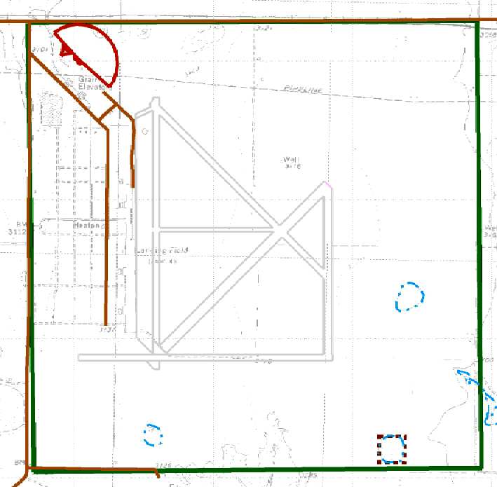
Benger Air Park (X54), Friona, TX
34.647, -102.694 (Southwest of Amarillo, TX)
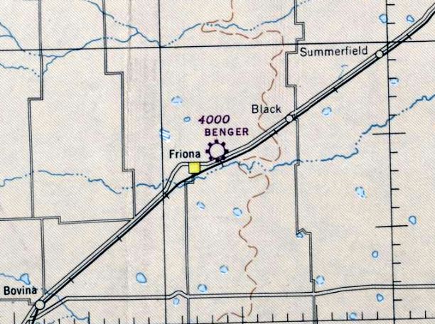
Benger Air Park, as depicted on the September 1945 Albuquerque Sectional Chart.
Yet another of America's disappearing grassroots small-town airports.
Benger Air Park was not yet depicted on the 1944 Albuquerque Sectional Chart.
According to its FAA Airport/Facility Directory Data, Benger Air Park was activated 6/1/44.
The earliest depiction which has been located of Benger Air Park was on the September 1945 Albuquerque Sectional Chart,
which depicted it as a commercial/municipal airport.
The earliest photo which has been located of Benger Air Park was a 9/16/54 USGS aerial view.
It depicted the field as having a single northeast/southwest unpaved runway, with 7 light aircrat & a few small buildings on the south side.
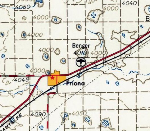
The earliest topo map depiction which has been located of Benger Air Park was on the 1958 USGS topo map.
The 1968 USGS topo map depicted Benger Airpark as having 4 unpaved runways & several small buildings on the south side.
A 10/20/78 USGS aerial view showed Benger Air Park to have 2 unpaved runways, with 1 light single-engine plane parked near several buildings on the south side.
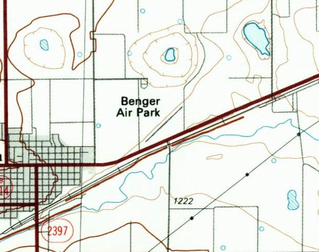
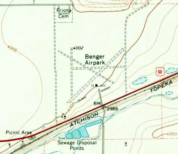
The 1992 USGS topo map depicted Benger Airpark as having a single northeast/southwest runway.
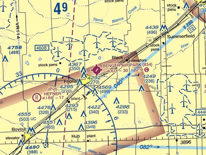
The last aeronautical chart depiction which has been located of Benger Air Park was on the 2022 Albuquerque Sectional Chart.
It depicted Benger Air Park as having a single northeast/southwest 3,000' paved runway.
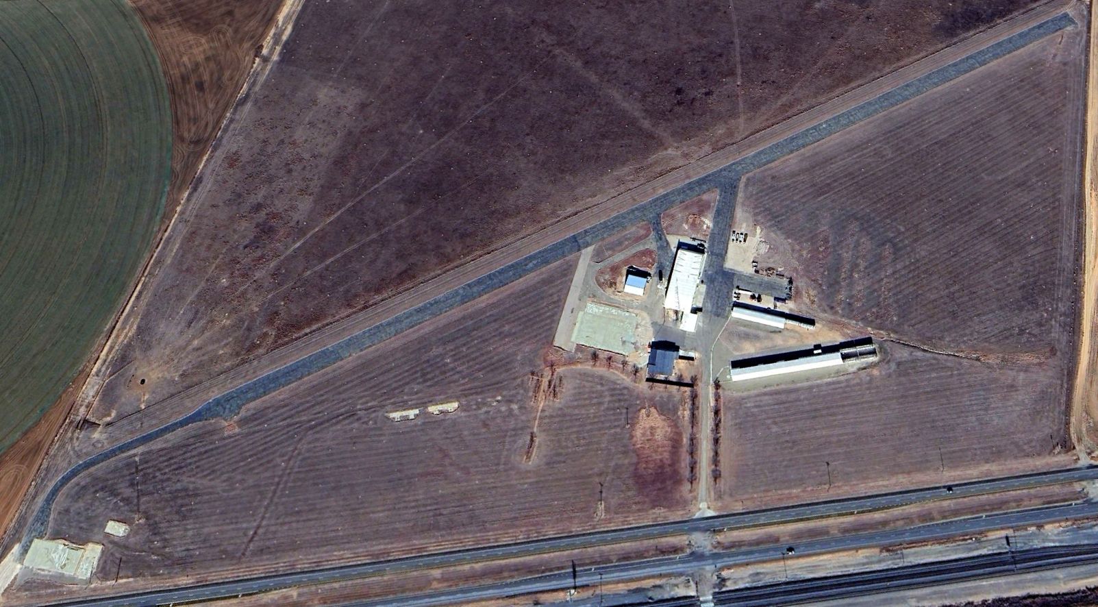
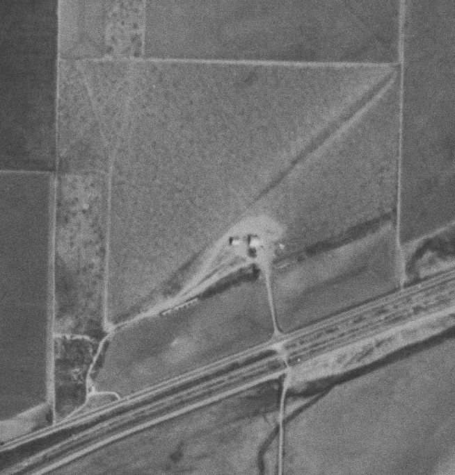
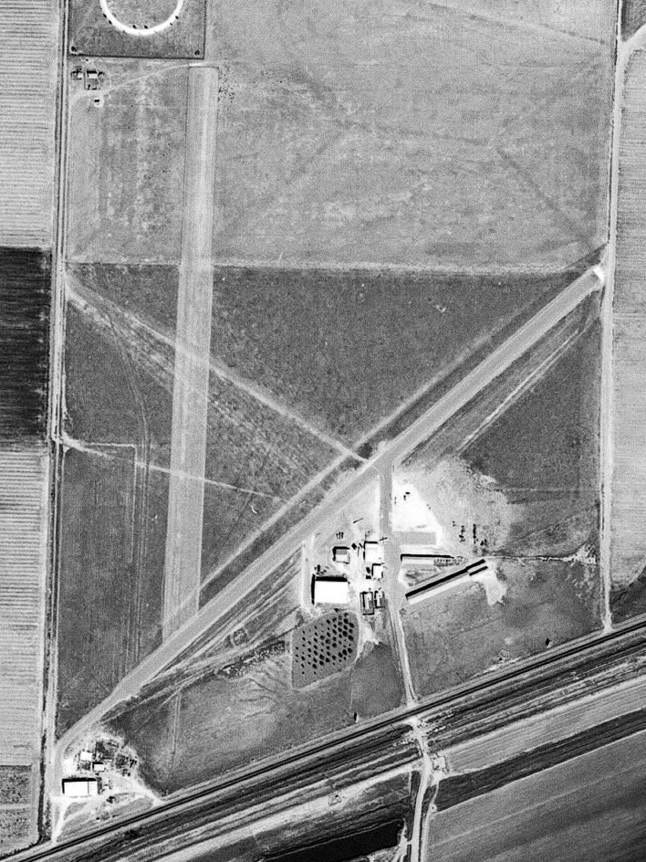
A 2023 aerial view looking northwest at Benger Air Park showed it remained intact, but without any runway markings or any other signs of recent aviation use.
Benger Air Park was evidently closed (for reasons unknown) at some point between 2023-24, as it was no longer depicted on the 2024 Albuquerque Sectional Chart.
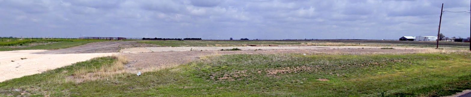
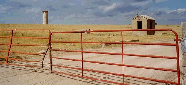
A 2024 photo looking northeast at the ramp at the southwest end of Benger Air Park, and the hangars in the distance on the right.
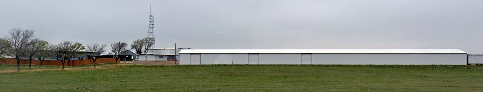
A 2024 photo looking north at the ramp at the hangars & beacon tower at Benger Air Park.
Thanks to Randy Coller for pointing out this airfield.
____________________________________________________
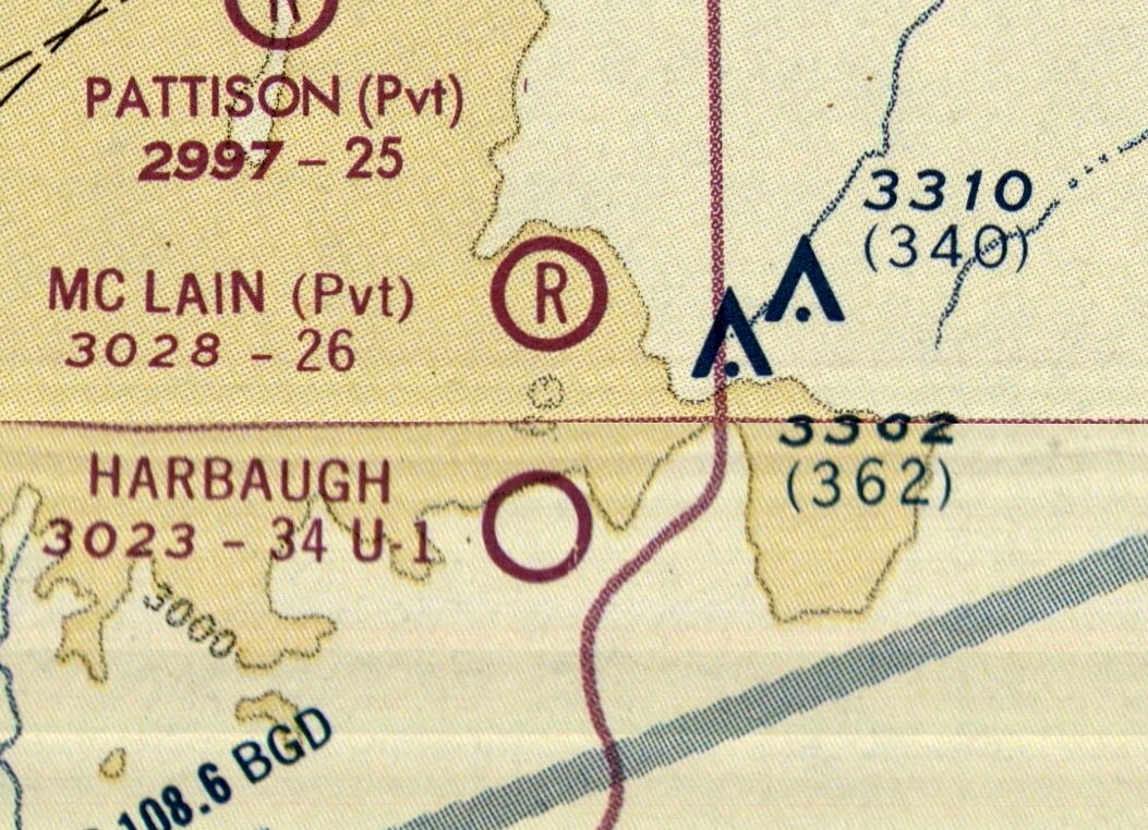
Harbaugh Airport, Perryton, TX
36.084, -100.867 (Northeast of Amarillo, TX)
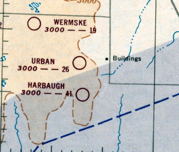
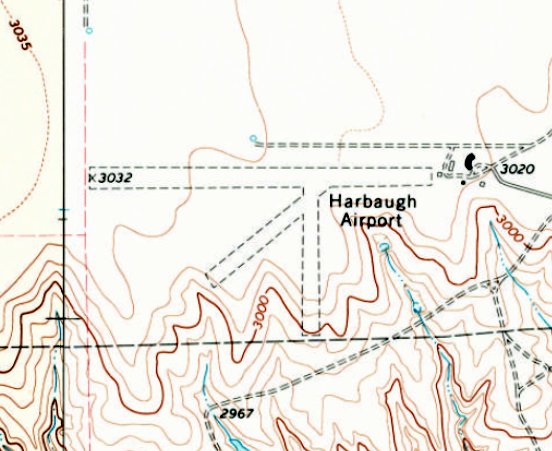
Harbaugh Airport, as depicted on the October 1951 Sectional Chart.
Jonathan Westerling reported, “This little countryside public airfield existed 22 miles south of Perryton, TX for 25 years.
The main reason for this may have simply been that it was at least that far to the next nearest public airfield.
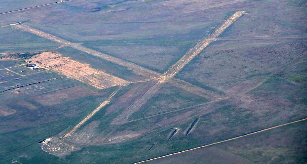
But the curious thing about this airfield was the runway layout.
One wide turf runway with ample length, but 3 tiny additional runways at various directions intersecting it.
Its not known why the owner created & then maintained the airport in this configuration throughout its life.”
The first reference which has been located of Harbaugh Airport was in the 1951 Airman's Guide (courtesy of Jonathan Westerling),
which listed it under the "new airports" section.
The earliest depiction which has been located of Harbaugh Airport was on the October 1951 Sectional Chart (courtesy of Jonathan Westerling),
which depicted it as having a 4,100' unpaved runway.
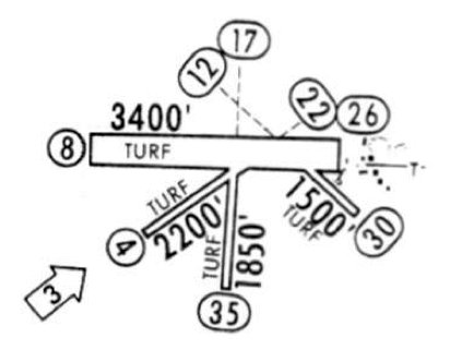
A 1967 Airport Directory (courtesy of Jonathan Westerling) depicted Harbaugh Airport with the unusual runway configuration
of a wide 3,400' turf runway & 3 short & narrow crosswind runways.
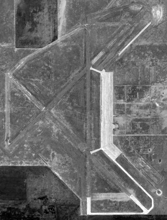
The earliest photo which has been located of Harbaugh Airport was a 1971 aerial view.
It depicted the field as having 3 unpaved runways, and several small buildings on the east side.
But there were no aircraft visible on the field.
The 1973 USGS topo map depicted Harbaugh Airport as having 3 unpaved runways, and several small buildings on the east side.
The last aeronautical chart depiction which has been located of Harbaugh Airport was on the 1974 Sectional Chart (courtesy of Jonathan Westerling),
which depicted it as having a 3,400' unpaved runway.
The last reference which has been located of Harbaugh Airport was in the 1976 AOPA Airports USA directory (courtesy of Jonathan Westerling),
which described it as a private airfield having 4 turf runways, the longest being the 3,400' Runway 9/27.
Harbaugh Airport appears to have been abandoned (for reasons unknown) by the time of a 1984 aerial view, as it showed the runways as appearing much less distinct.
Harbaugh Airport was evidently closed by 2012, as it was no longer depicted on the 2012 USGS topo map.
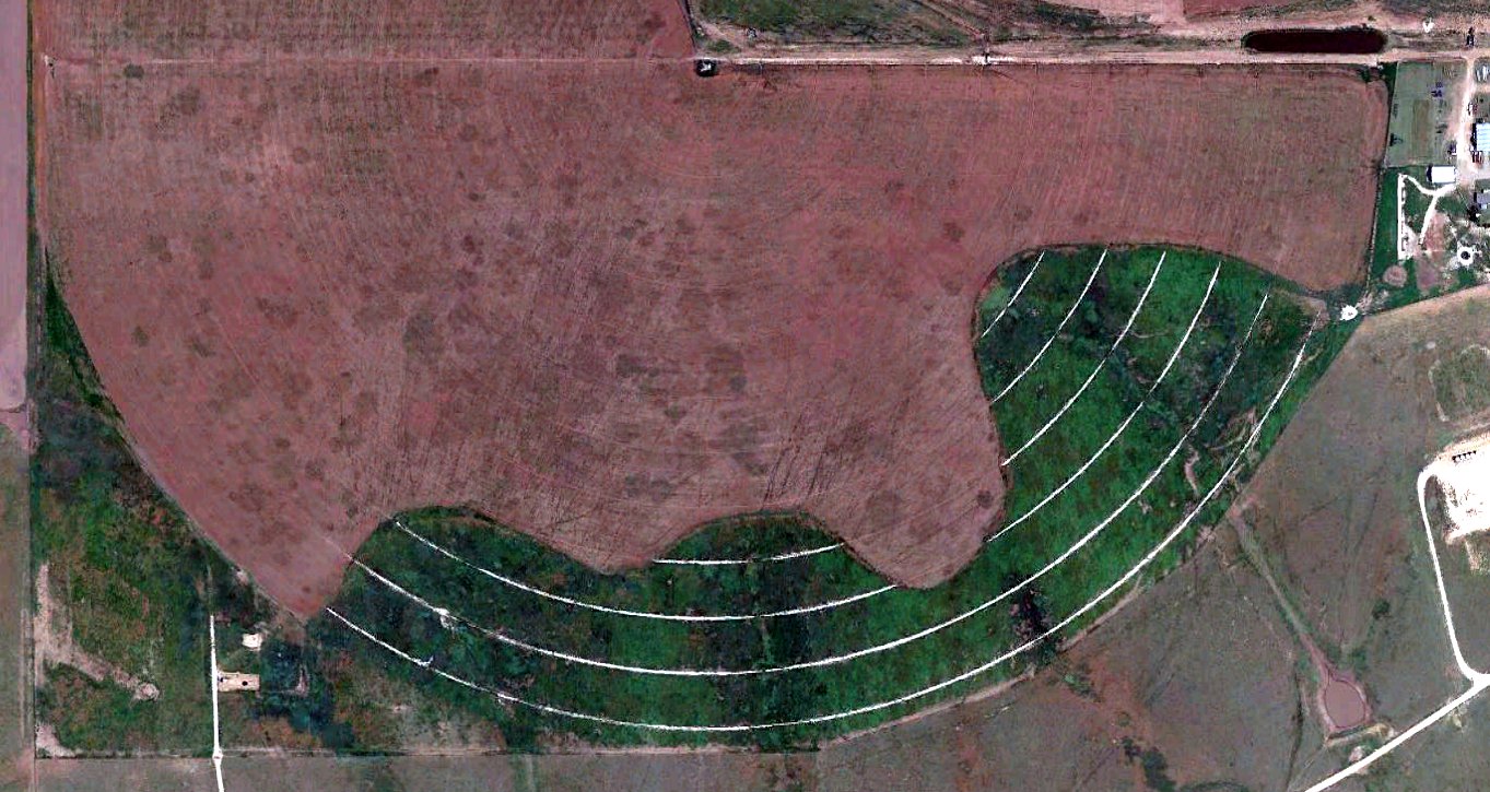
A 2019 aerial view showed no trace remaining of Harbaugh Airport, with the site covered by a center-pivot farm field.
____________________________________________________
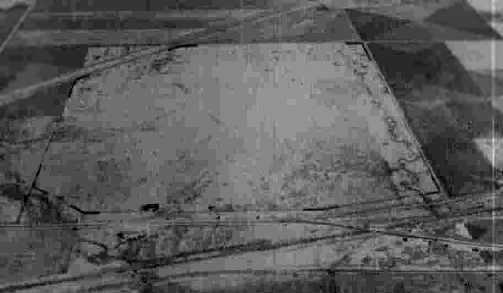
Twitty Intermediate Field, Twitty, TX
35.3, -100.22 (East of Amarillo, TX)
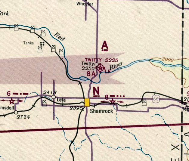
Twitty Intermediate Field, as depicted on the September 1942 Oklahoma City Sectional Chart.
This airfield was evidently one of the network of Intermediate Fields constructed by the Commerce Department
for the emergency use of commercial aircraft along airways between major cities.
Twitty Intermediate Field was evidently established at some point between 1941-42,
as it was not yet depicted on the September 1941 Oklahoma City Sectional Chart.
The earliest depiction which has been located of Twitty Intermediate Field was on the September 1942 Oklahoma City Sectional Chart.
The earliest photo which has been located of Twitty Intermediate Field
was a 7/13/43 aerial view looking north from the July 1944 AAF Airfield Directory (courtesy of Rhonda Weriwether).
It depicted Twitty Intermediate Field as having several unpaved runways.
The July 1944 AAF Airfield Directory (courtesy of Rhonda Weriwether) described Twitty Intermediate Field as a 146 acre irregularly-shaped property
having 4 sod runways, with the longest being the 3,766' northwest/southeast runway.
The field was said to not have any hangars, to be owned by private interests, and operated by the Civil Aeronautics Administration.
The 1945 AAF Airfield Directory (courtesy of Scott Murdock) described Twitty Intermediate Field in the same fashion.
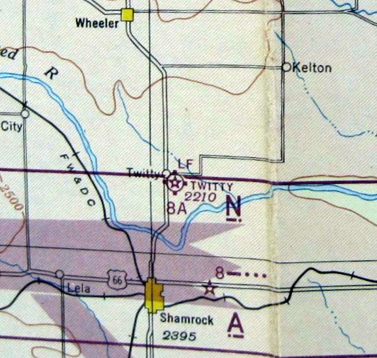
The 1945 OK City Sectional Chart depicted Twitty as a commercial/municipal airport, and labeled it as Site 8A along the airway.
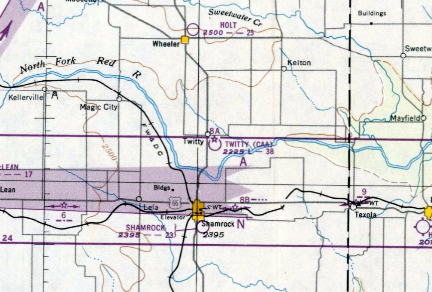
The last aeronautical chart depiction which has been located of Twitty Intermediate Field was on the February 1950 OK City Sectional Chart,
which depicted “Twitty (CAA)” as Site 8A along the airway, with a 3,800' unpaved runway.
Twitty Intermediate Field was evidently abandoned at some point in 1950,
as it was no longer depicted on the August 1950 OK City Sectional Chart.
Most of the Intermediate Fields in rural areas were abandoned as advances in the range & reliability of commercial aircraft made the Intermediate Fields unnecessary.
Twitty Intermediate Field was no longer depicted on the 1954 USGS topo map.
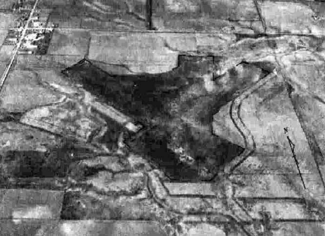
Amazing a 1996 aerial view of the site of Twitty Intermediate Field showed that the diagonal runway alignment of several runways
was still recognizable more than 50 years after the airport was abandoned.
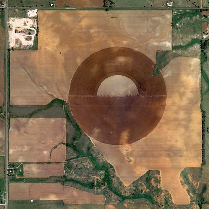
A 2014 aerial view shows a circular irrigation plot was built over the site of Twitty Intermediate Field,
but traces of the diagonal runway alignment was still recognizable on the south end of the airfield site.
The site of Twitty Intermediate Field is located southeast of the intersection of Route 83 & Route 592.
Thanks to Rhonda Meriwether for pointing out this airfield.
____________________________________________________
KFDA-TV Airfield, Amarillo, TX
35.29, -101.84 (North of Downtown Amarillo, TX)
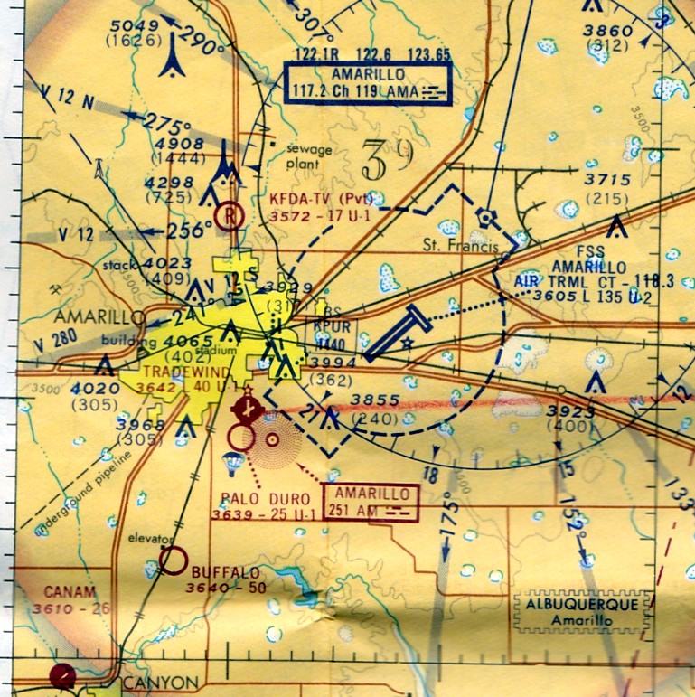
The KFDA-TV airfield, as depicted on the March 1962 Oklahoma City Sectional Chart (courtesy of David Brooks).
Photo of the airfield while open has not been located.
According to John Fullingim, “The KFDA strip was established by a KFDA weather man in the 1950s.
His name was Dan True & he was a local celebrity.
He had a Piper Cub & lived down near Palo Duro Canyon & flew to work many days.
I worked with him at KGNC. He often talked about his flying on the air & was quite a character.”
The KFDA-TV Airfield was not yet depicted on the 1961 Oklahoma City Sectional Chart (according to David Brooks).
The earliest depiction of the KFDA-TV Airfield which has been located
was on the March 1962 Oklahoma City Sectional Chart (courtesy of David Brooks).
It depicted KFDA-TV as a private airfield having a 1,500' unpaved runway.
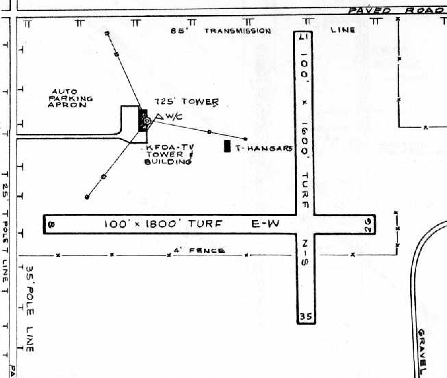
The 1966 TX Airport Directory (courtesy of David Brooks) depicted the KFDA-TV Airfield
as having 2 turf runways: 1,800 Runway 8/26 & 1,600 Runway 17/35.
The runways were located immediately adjacent to the southeast of the tower & supporting wires of the television transmitter,
which must have made approached to the runways quite interesting.
A single building of T-hangars was located northwest of the runway intersection.
The operator was listed as Dan True [who was also the weatherman at KFDA-TV].
The 1966 AOPA Airport Directory (according to David Brooks) described the KFDA-TV Airfield
as having 3 runways, all turf/sod, with the longest being the 1,500' Runway 9/27.
The operator was listed as Dan True,
and warnings were included for high towers & electrical power lines around the edges of the airfield.
No hangar facilities were described - just tie-downs.
A 1967 aerial photo showed an open grass field, without any recognizable runways, with the single T-hangar building on the northwest side.
USGS topo maps from the 1960s, 1970s, and 1980s did not depict an airfield of any kind.
The last aeronautical chart depiction which has been located of the KFDA-TV Airfield was on the February 1973 DFW Sectional Chart (courtesy of Ron Plante).
It depicted KFDA-TV as a private airfield having a 1,700' unpaved runway.
According to John Fullingim, “The gigantic transmission towers were built in the early 1970s, and were not there when Dan was at KFDA.
I have been to the KFDA site many times.”
The KFDA-TV Airfield was evidently closed at some point between 1973-78,
as it was no longer depicted on the 1978 DFW Sectional Chart (according to David Brooks).
The 1995 USGS aerial photo showed that a new transmitter tower had been built somewhat to the east of the old one,
roughly over the northern portion of the former airfield.
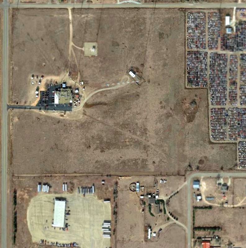
In a 2014 aerial photo, traces of the 2 former KFDA Airfield runways were still apparent, but no airfield buildings appeared to remain.
The site of the KFDA-TV Airfield is located southeast of the intersection of West Cherry Avenue & Broadway Road.
____________________________________________________
(Original) Amarillo Municipal Airport, Amarillo, TX
35.23, -101.78 (Northeast of Downtown Amarillo, TX)
The original Amarillo Airport, as depicted on the November 1937 Oklahoma City Sectional Chart.
The original Amarillo Municipal Airport was located 6 miles northeast of the center of the town.
Amarillo Municipal Airport was evidently established at some point between 1936-37,
as it was not yet depicted on the November 1936 OK City Sectional Chart.
The earliest depiction which has been located of Amarillo Municipal Airport was on the November 1937 Oklahoma City Sectional Chart.
It depicted Amarillo as a commercial/municipal airport.
The earliest photo which has been located of the Amarillo Municipal Airport
was a 10/13/43 aerial view looking north from the 1945 AAF Airfield Directory (courtesy of Scott Murdock).
It depicted the field as consisting of a square unpaved landing area.
According to Jim Foreman, “The big hangar in the photo was to house the planes of TAT & Trans Western on their overnight stops there.
Providing the hangar space free of charge was the way to get them to move their overnight stop
from Portales, NM where they were being charged for each night they were there.
When the officials at Amarillo heard that Lindbergh & his entourage would land there for fuel,
they organized an official dedication during which they would name it Lindbergh Field.
They built a stage for the event & even had the high school marching band there to play for the event.
When Lindbergh landed, he went to the bathroom & right back to his ship without stopping,
then he & all the rest of the airplanes in his flight left without paying for their fuel.
They painted over the name and changed it to Amarillo Municipal Airport.
When I soloed there in 1944, you could still see 'Lindbergh Field' through the white paint covering it.”
Jim continued, “Harold English, who was operating his flight school from a runway on the east side of Fillmore Street & north of the railroad tacks,
applied for the position of Airport Manager but the mayor blocked it saying he would never hire a drunk to manage the city airport.
That was what prompted English, backed by his brother-in-law, Thornton Oxnard (playboy son of Henry Oxnard who founded Oxnard, CA)
to buy a section of land 5 miles east of Amarillo Municipal to build his own airport
and through a stock deal with the 2 airlines, got them to move their operation to the new English Field.”
Jim continued, “Bob Siler was manager of Amarillo Municipal airport when I soloed there on my 16th birthday, 11/3/44.
The 2 buildings just west of the main hangar were the offices of 2 flight schools.
The larger square hangar was built after I soloed but before I got my Private Pilot's License a year later.”
The April 1944 US Army/Navy Directory of Airfields (courtesy of Ken Mercer)
described Amarillo Airport as having a 1,500' hard-surface runway, with a "5,200' x 4,500' all-way field available".
It also indicated that Army flight operations were conducted from the field.
The original Amarillo Airport, as depicted on the 1944 Oklahoma City Sectional Chart (courtesy of David Brooks).
The 1945 AAF Airfield Directory (courtesy of Scott Murdock) described Amarillo Municipal Airport
as a 460 acre irregularly-shaped property within which were 2 bituminous runways (1,458' northeast/southwest & 1,000' NNW/SSE)
within a 4,500' x 3,000' all-way sod landing area.
The field was said to have 4 hangars, the largest being a 105' x 90' brick & steel structure.
Amarillo Municipal Airport was said to be owned by the City of Amarillo & operated by private interests.
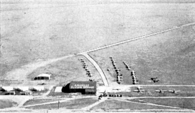
An undated aerial view of the original Amarillo Airport from the Haire Publishing Company's 1948 Airport Directory (courtesy of David Brooks).
The directory described the field as consisting of an area measuring 5,200' x 4,500' x 3,000',
within which were 3 paved runways.
The photo depicted several hangars (one of which had “Amarillo Flying Service” painted on the roof),
along with dozens of light aircraft.
According to Jim Foreman, “The runway was paved some time in 1948.
There was a relatively famous honky-tonk nightclub right across Highway 60 from the airport.
It was called the Aviatrix Club & was decorated with pictures of famous women aviators of the time.
A Staggerwing Beech lost the engine on takeoff, slid across the highway,
into the front of the club & all the way across the dance floor where it came to rest on the bandstand.
All 5 people aboard walked away.”
The 1949 OK City Sectional Chart (courtesy of John Price) depicted the original Amarillo Airport as it as having a 5,200' unpaved runway.
The last chart depiction which has been located of the original Amarillo Airport as an active airfield was on the March 1950 Albuquerque Sectional Chart,
which depicted it as having a 5,200' unpaved runway.
According to Jim Foreman, “Amarillo Municipal closed around 1950
and a company called Old Scratch bought it to manufacture a machine for cattle to scratch themselves on to get rid of Common Cattle Grubs under the skin on their backs.
When it went out of business, the building was bought by a company to build anhydrous ammonia tanks to store & spread fertilizer.
It was owned by Billy Sol Estes who became more or less famous in his association with Lyndon Johnson
and a multi-million dollar scam in which the government financed the tanks for farmers.
Much of the aviation history is incorporated in my book, AMARILLO.”
The original Amarillo Airport was no longer depicted on the 1954 Albuquerque Sectional Chart (according to David Brooks),
nor on the 1956 USGS topo map.
No trace of the original Amarillo Airport was recognizable on a 1967 aerial photo.
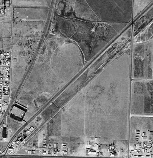
In the 1995 USGS aerial photo, not a trace of the original Amarillo Airport was recognizable.
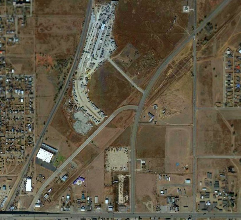
In a 2014 aerial photo, not a trace of the original Amarillo Airport was recognizable.
The site of the original Amarillo Airport is located northeast of the intersection of Route 50 & Route 136.
____________________________________________________
Dalhart Aux AAF #1 / West Field, Dalhart, TX
36, -102.69 (Northwest of Amarillo, TX)
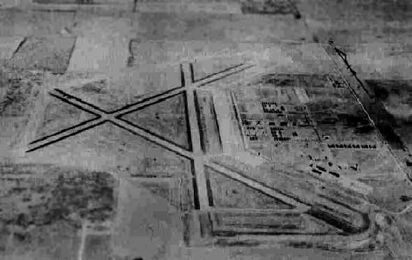
A 10/13/43 aerial view looking north at “Dalhart Army Air Field Auxiliary #1 (West Field)”
from the 1945 AAF Airfield Directory (courtesy of Scott Murdock).
This very large airfield was built during WW2 as one of 2 auxiliary fields for Dalhart AAF,
(a few miles to the east), which conducted training in the B-17, B-24, B-29, B-32, and also the Waco glider.
Dalhart Aux #1 was evidently established at some point in 1943,
as it was not yet depicted on the February 1943 Albuquerque Sectional Chart.
The earliest depiction which has been located of Dalhart Aux #1
was a 10/13/43 aerial view from the 1945 AAF Airfield Directory (courtesy of Scott Murdock).
It depicted “Dalhart Army Air Field Auxiliary #1 (West Field)” as having 3 paved runways, with a large paved ramp on the east side
and a substantial number of buildings on a street grid to the east of the ramp.
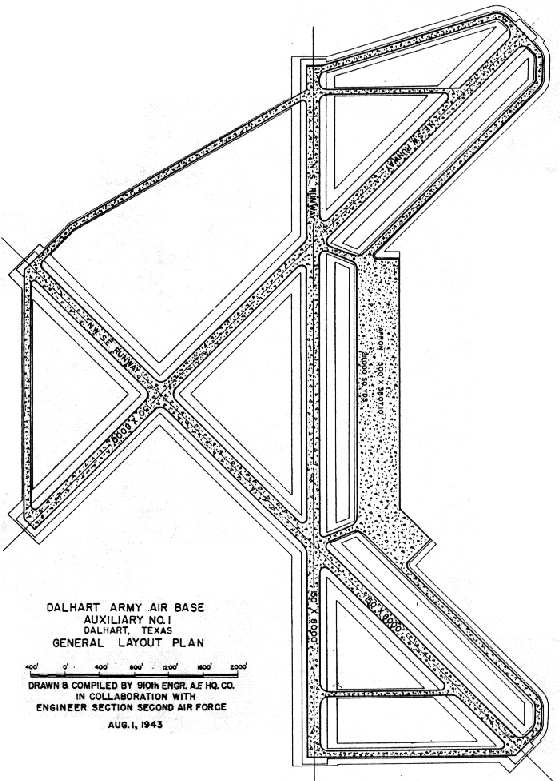
As depicted on a 1943 Army plan (courtesy of John Voss), Dalhart Aux AAF #1 consisted of 3 paved 8,000' runways,
taxiways & a large concrete ramp (measuring 211,000 square yards).

The earliest aeronautical chart depiction which has been located of the Dalhart Auxiliary #1 Airfield was on the February 1944 Trinidad Sectional Chart.
It depicted Dalhart Aux #1 as having its own control tower.
According to Matthew Byrd (who grew up adjacent to Dalhart AAF), Auxiliary Field #1 was known as the West Base among locals.
There were several other areas designated for dropping dummy munitions spaced in between the bases (one of them northeast of Conlen).
According to Byrd, the West Base was also used as a camp for German prisoners of war.
The 1945 AAF Airfield Directory (courtesy of Scott Murdock) described “Dalhart Army Air Field Auxiliary #1 (West Field)”
as a 1,910 acre square-shaped property within which were 3 bituminous 8,100' runways,
oriented north/south, northeast/southwest, and northwest/southeast.
The field was said to have a single 202' x 117' steel & wood hangar,
to be owned by the U.S. Government, and operated by the Army Air Forces.
However, the title of the listing described the field as Inactive.
The last aeronautical chart depiction which has been located of "Dalhart AF #1" was on the November 1954 Trinidad Sectional Chart.
It depicted “Dalhart AF #1” as having an 8,100' paved runway.
Dalhart Aux #1 was evidently abandoned at some point between 1954-55,
as it was no longer depicted on the November 1955 Trinidad Sectional Chart.
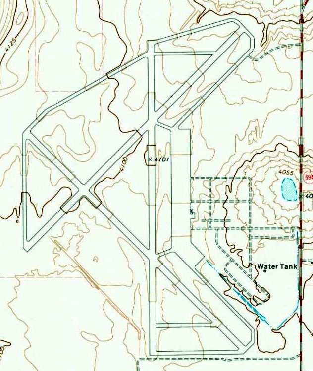
The 1973 USGS topo map depicted the extensive airfield of Dalhart Aux AAF #, with 3 paved runways, taxiways, and ramps,
but did not label the field at all.
As of the 1996 USGS aerial photo, the outlines of the runways & taxiways were still plainly apparent, but most of their pavement had been removed.
The ramp pavement still remained, as the ramp may have been used as a makeshift runway after the runways themselves were removed (as was done at Dalhart Aux #2).
It appears as if the single hangar had been removed, but its walls remained standing (also just like the hangar at Dalhart Aux #2).
The locked gate at the entrance to Dalhart Aux #1, 1998.
A water tower & the concrete sides of a hangar still remain.
A 1996 USGS aerial photo showed that portions of pavement of several of the runways of Dalhart Aux AAF #1 had been removed,
but the ramp pavement remained intact.
A 10/11/14 aerial view by Mike Brown looking southwest at the extensive remains of Dalhart Auxiliary Field #1.
A 2013 aerial photo showed the deteriorated remains of the extensive airfield at Dalhart Aux AAF #1.
____________________________________________________
Dalhart Aux AAF #2 / Miller Field (2E1), Dalhart, TX
36.09, -102.42 (Northwest of Amarillo, TX)
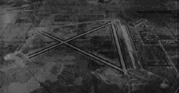
A 10/13/43 aerial view looking north at “Dalhart Army Air Field Auxiliary #2 (East Field)”
from the 1945 AAF Airfield Directory (courtesy of Scott Murdock).
This field was built during WW2 as one of 2 auxiliary fields for Dalhart AAF,
(a few miles to the southwest), which conducted training in B-17s, B-24s, B-29s & B-32s.
It was also known as Witt Field.
Dalhart Aux #2 was evidently established at some point in 1943,
as it was not yet depicted on the February 1943 Albuquerque Sectional Chart.
The earliest depiction which has been located of Dalhart Aux #2
was a 10/13/43 aerial view from the 1945 AAF Airfield Directory (courtesy of Scott Murdock).
It depicted “Dalhart Army Air Field Auxiliary #2 (East Field)”
as having 3 paved runways, with a large paved ramp on the east side
and a substantial number of buildings on a street grid to the east of the ramp.
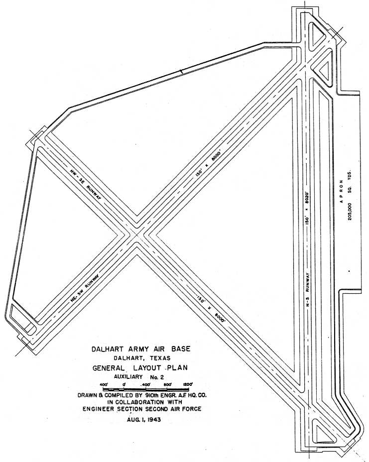
As depicted on a 1943 Army plan (courtesy of John Voss),
Dalhart Aux AAF #2 consisted of 3 paved 8,000' runways,
taxiways & a large concrete ramp (measuring 205,000 square yards).
The earliest aeronautical chart depiction which has been located of the Dalhart Auxiliary #2 Airfield was on the February 1944 Trinidad Sectional Chart.
It depicted Dalhart Aux #2 as having its own control tower.
The 1945 AAF Airfield Directory (courtesy of Scott Murdock) described “Dalhart Army Air Field Auxiliary #2 (East Field)”
as an irregularly-shaped property within which were 3 bituminous 8,500' runways,
oriented north/south, northeast/southwest, and northwest/southeast.
The field was said to not have any hangars, and to be operated by the Army Air Forces.
However, the title of the listing described the field as Inactive.
According to Matthew Byrd (who grew up adjacent to Dalhart AAF), Auxiliary Field #2 was known as the East Base among locals.
The last aeronautical chart depiction which has been located of "Dalhart AF #2" was on the November 1954 Trinidad Sectional Chart.
It depicted “Dalhart AF #2” as having an 8,000' paved runway.
Dalhart Aux #2 was evidently abandoned at some point between 1954-55,
as it was no longer depicted on the November 1955 Trinidad Sectional Chart
or the February 1968 Albuquerque Sectional Chart.
The former Dalhart Aux #2 field was apparently reopened as a civilian airport at some point between 1968-70,
as it was listed as Miller Field in the 1970 TX Airport Directory (courtesy of Ray Brindle).
It was named for Delmar Miller, a WW2-era instructor.
According to Matthew Byrd, Miller Field "used to be a hopping place in the 1960s & 1970s."
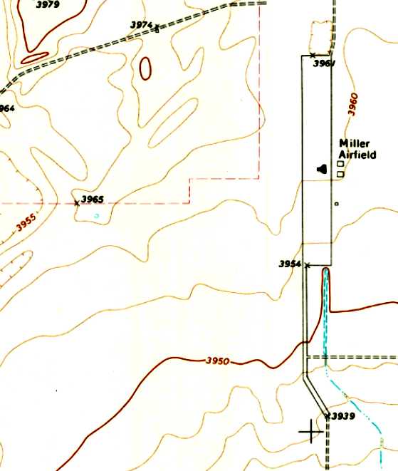
The 1973 USGS topo map depicted the former Dalhart Aux #2 ramp as “Miller Airfield”.
Three buildings were depicted to the east of the ramp, and 1 building was depicted on the ramp.
The former runways were no longer depicted at all.
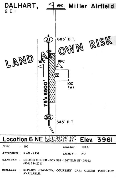
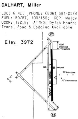
The 1985 TX Airport Directory (courtesy of Steve Cruse) showed that Miller Field had reused the former Dalhart #2 ramp & taxiway as a 6,500' Runway 17/35.
The manager was listed as Delmar Miller.
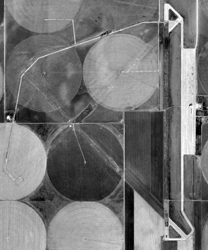
In the 1996 USGS aerial photo of the site of Dalhart #2, the remnants of the 3 former paved runways were still discernible, although most of their pavement had been removed.
The paved ramp & taxiway on the east side of the field remained intact, but there was no sign of any based aircraft.
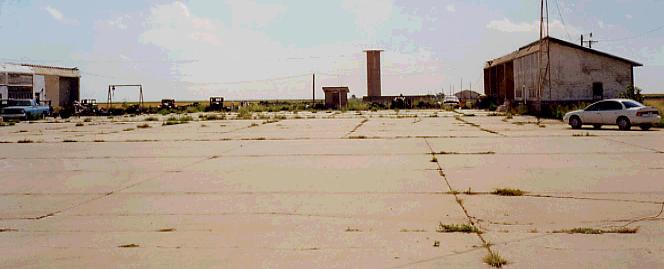
The still-standing concrete sides were the only remaining portions of a hangar at Dalhart Aux #2 in 1998, being used for storage.
As of 2002, the field was still in use as Miller Field, which supports infrequent crop-dusting operations.
It was described as being nearly deserted by general aviation pilots who have visited,
although the FAA Airport/Facility Directory listed a total of 4 aircraft as being based at the field.
Miller Field was evidently abandoned (for reasons unknown) at some point between 2002-2006,
as it was no longer listed in the FAA Airport/Facility Directory as of 2006 (according to Chris Kennedy).
Mike Brown reported from a 10/15/11 overflight, “I saw Dalhart #2, but I didn’t realize [at the time] it was what’s left of a WWII bomber field.
All you can see is the ramp, and it looks like an incredibly wide but not very long runway.”
Michael Dennis reported on 7/27/13, “Dalhart Aux #2: I wandered into this site when I saw the airport sign.
There are 2 cropdusters & what looked like a Cessna 172.
They were all more or less in a open hangar & no one [was] around.
Apparently the hangar was of postwar construction.
There was an office that looked like a Unicom office but open to the environment.
Judging from the interior ....probably early 1970s. Definitely not being used as a regular airport.”
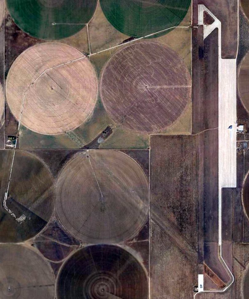
A 2013 aerial photo showed the remnants of Dalhart Aux AAF #2's three former paved runways were still discernible,
although most of their pavement had been removed (except oddly for the very ends of most of the runways).
The paved ramp & taxiway on the east side of the field remained intact.
____________________________________________________
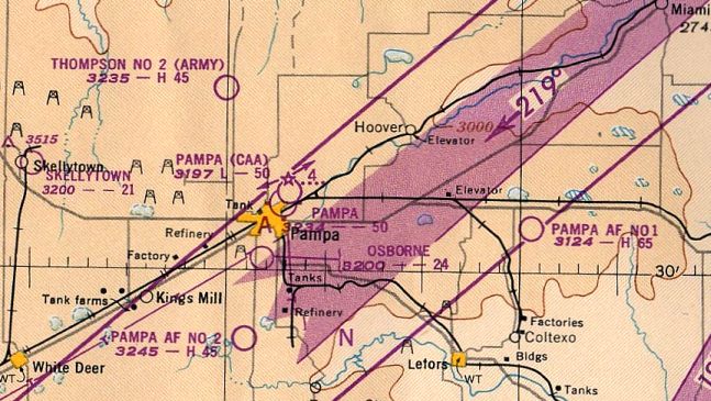
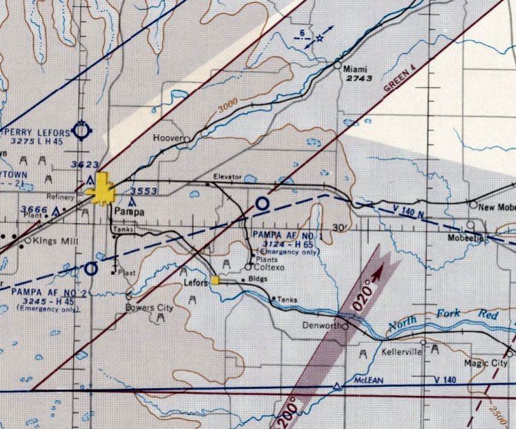
Pampa Army Airfield, Pampa, TX
35.53, -100.76 (Northeast of Amarillo, TX)
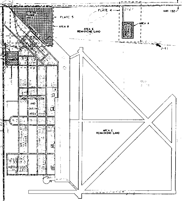
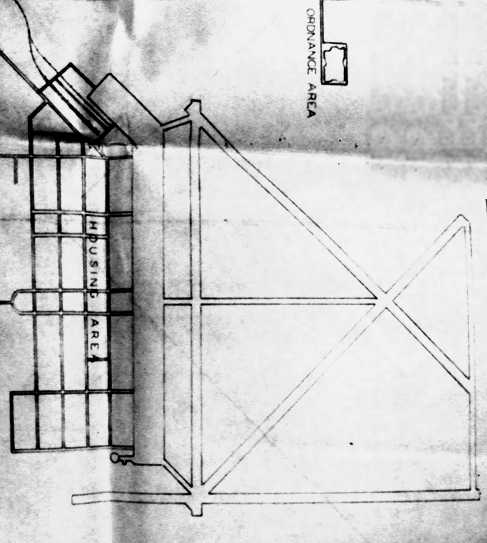
A 1942 U.S. Army facility area map of Pampa AAF.
No airfield was depicted at this location on OK City Sectional Charts from 1932, 1935, 1940, and September 1942.
This site was reportedly a “pre-WW2 airfield” which was taken over in 1942 by the AAF as part of the 70,000 Pilot Training Program.
However the assertion that it was a pre-WW2 airfield was contradicted by its lack of depiction on pre-WW2 aeronautical charts.
Pampa Field was established by the Army Air Corps as a twin-engine flying school, offering advanced twin-engine training in AT-10s.
Also stationed at the field were AT-9s, B-25s, and AT-17s.
The military airfield site encompassed 2,545 acres. It was also known as the "Eagles' Nest of the High Plains".
The earliest depiction which has been located of Pampa AAF was a 1942 U.S. Army facility area map.
It depicted Pampa as having 4 paved runways, with a large paved ramp on the west side,
and a “Administrative & housing area” street grid to the west of the ramp.
Calvin Casteel recalled, “I did Advanced Flight Training in AT-9, AT-10, and AT-17s at Pampa Army Air Field, graduating in 2/16/43.”
Improvements to the site included four 3,500' runways, a large paved ramp area, hangars,
a street grid with numerous buildings, water wells & a tower, a sewage disposal plant, and ordnance areas & a skeet range.
A 5/15/43 AAF list of airfields of the Gulf Coast Training Center (courtesy of Ron Plante)
described Pampa Field as having 4 asphalt runways, with the longest being the 6,540' northeast/southwest & northwest/southeast strips.
It listed Pampa as having a total of 6 satellite fields:
Reeves Aux #1 (6 miles south of Pampa, TX), Thompson Aux #2 (6 miles NNW of Pampa, TX), later reused as Perry Lefors Airport,
Hoover Aux #3 (9 miles northwest of Pampa AAF), of which no trace remains,
Laketon Aux #4 (9 miles ENE of Pampa AAF), of which no trace remains, Jericho, and Pampa CAA.
The earliest photo which has been located of Pampa AAF
was a 10/13/43 aerial view looking north from the 1945 AAF Airfield Directory (courtesy of Scott Murdock).
It depicted Pampa as having 4 paved runways, with a large ramp on the west side,
with a large number of buildings west of the ramp.
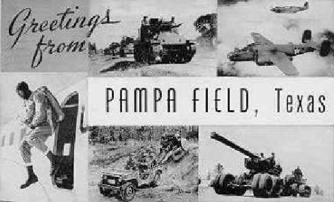
A circa-1943 postcard from Pampa Field (courtesy of Steve Cruse).
The earliest aeronautical chart depiction which has been located of Pampa AAF was on the April 1944 OK City Sectional Chart (courtesy of Ron Plante).
Note that Pampa's eventual complement of auxiliary airfields were not yet depicted.
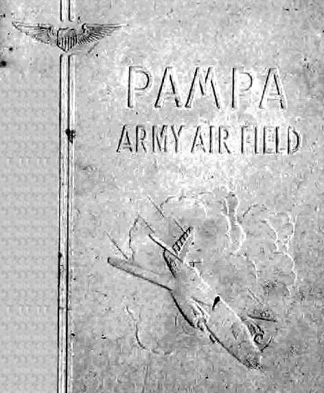
An undated cover of a Pampa Army Air Field book.
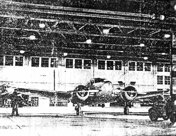
An AT-17 trainer being prepared for a night flight inside a Pampa hangar during WW2.
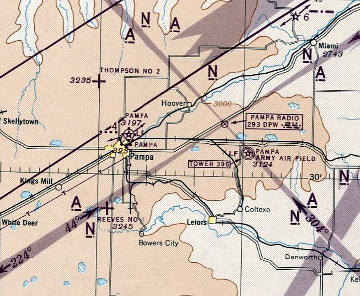
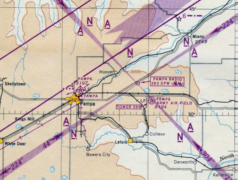
Pampa AAF & its satellite fields, as depicted on the October 1945 Oklahoma City Sectional Chart (courtesy of John Voss).
During its 3 years of operation Pampa AAF graduated 6,292 cadets, until it closed in 1945.
The 1945 AAF Airfield Directory (courtesy of Scott Murdock) described Pampa AAF
as a 2,544 acre square-shaped property within which were 4 bituminous runways,
the longest being the 6,540' northeast/southwest & northwest/southeast strips.
The field was said to have a total of 5 wooden hangars, the largest being a 202' x 163' structure.
Pampa was said to be owned by the U.S. Government, and operated by the Army Air Forces,
and to have 2 auxiliary fields (Reeves #1 & Thompson #2).
The other 4 auxiliary fields were evidently abandoned before 1945.
However, the title of Pampa AAF's listing described the field as Inactive.
A 1946 “Key Plan” (National Archives, courtesy of Ron Plante) depicted Pampa Army Airfield
as having 4 paved runways, taxiways, a large ramp, a street grid in a housing area, and an ordnance area to the north.
Pampa AAF was transferred as surplus to the Corps of Engineers in 1947.
It was then acquired by the Air Force in 1948 & redesignated Pampa AF Auxiliary Field #1.
It was depicted as "Pampa AF #1" on the 1949 Oklahoma City Sectional Chart (courtesy of John Price).
The Pampa airfield remained on the Air Force property rolls until at least 1952, but was then closed again.

A 10/13/54 USGS aerial view depicted Pampa AAF as having 4 paved runways, with a large ramp on the west side, and at least 4 hangars still standing.
The Pampa airfield property was declared excess by the military in 1955.
The last topo map depiction which has been located of the Pampa airfield was on the 1956 USGS topo map,
which labeled the field as "Pampa AF #1".
The last aeronautical chart depiction which has been located of Pampa Field was on the March 1956 Oklahoma City Sectional Chart.
It depicted “Pampa AF #1” as having a 6,500' paved runway, but also indicated “Emergency use only”, which evidently foreshadowed the airfield's abandonment later that year.
Pampa Field was evidently abandoned at some point in 1956,
as it was no longer depicted at all on the September 1956 OK City Sectional Chart.
The last tract of land of the Pampa airfield was sold in 1957.
Calvin Casteel recalled, “I visited what was remaining of Pampa Army Air Field in 1963 -
all that remained was a couple of hangars & part of the ramp which was being used as a cattle feed lot.”
The Pampa airfield was no longer depicted at all on the 1965 topo map.
A 3/22/66 USGS aerial view of 2 of the 4 Pampa AAF hangars which remained standing.
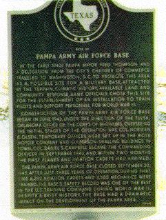
In 1982 a Texas Historical Commission historical marker was placed near the site,
at the intersection of Rt.152 & Farm Road 3302.
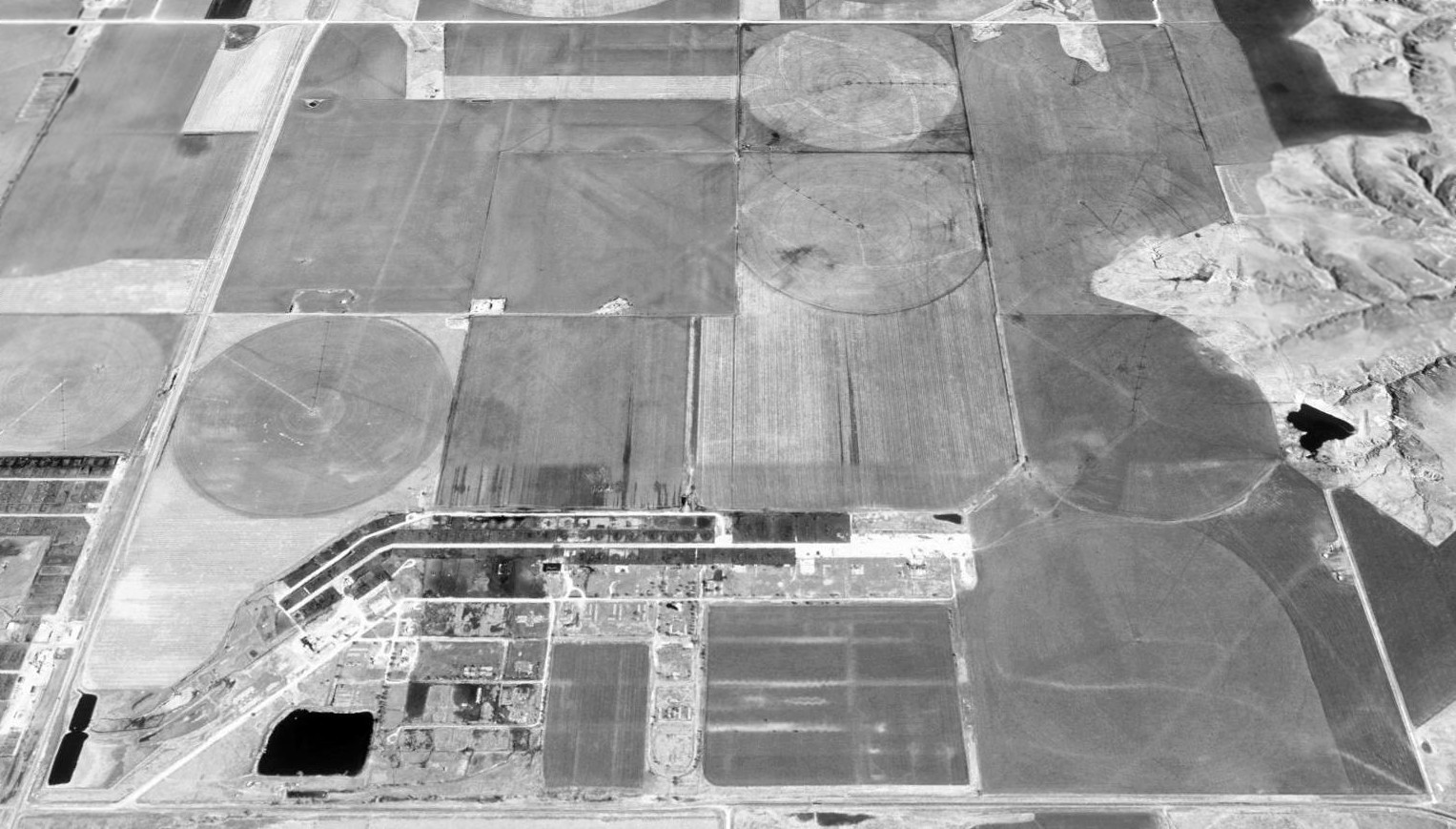
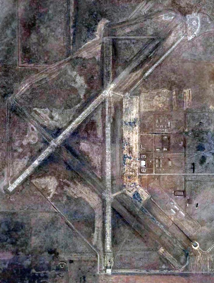
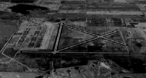
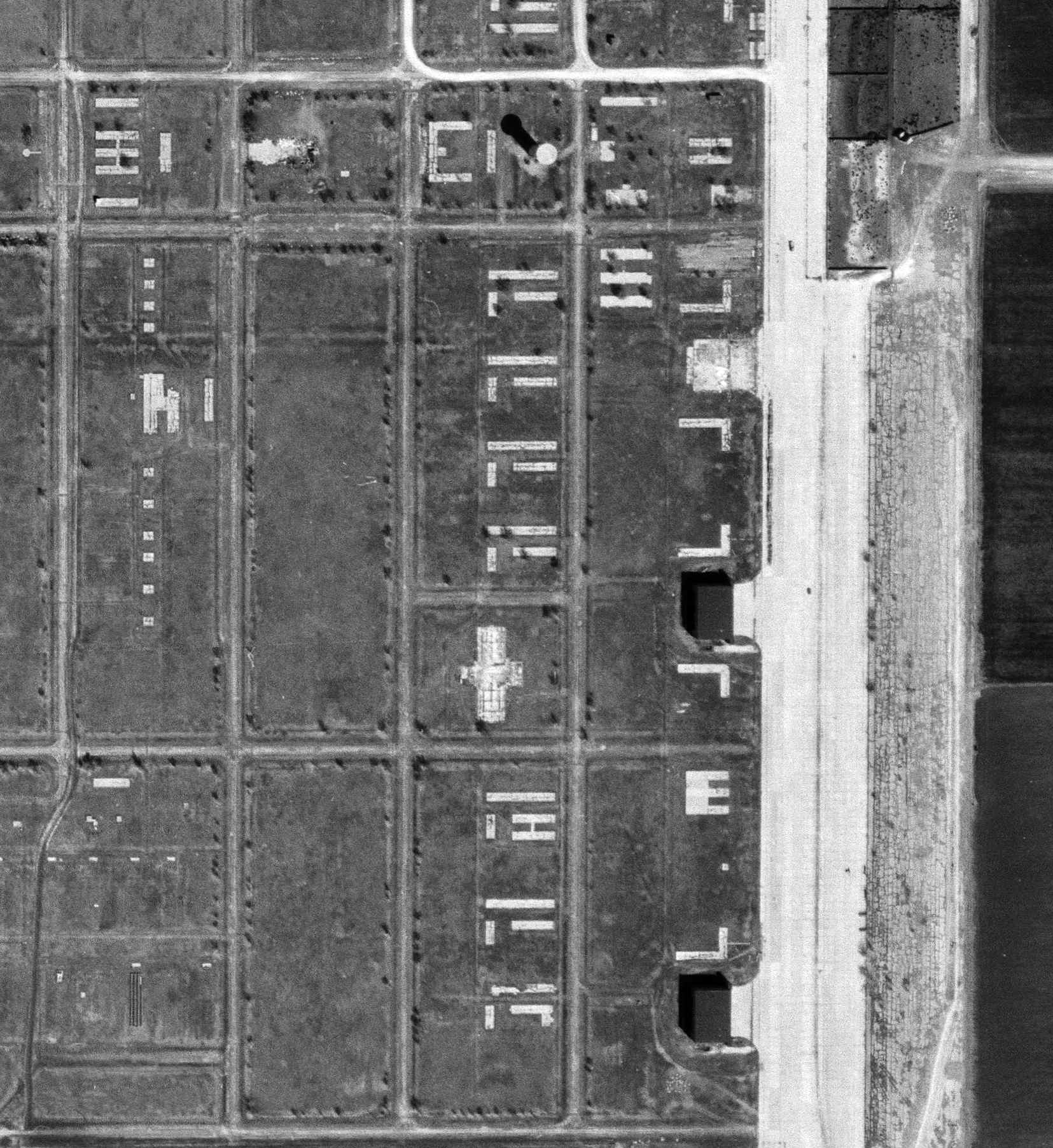
A 1996 USGS aerial view looking east showed the only remaining elements of Pampa AAF were portions of the paved ramp area & street grid.
All of the runways had been removed, with their location reverted to farmland,
but a faint ghosted outline of their diagonal orientation was still barely discernible in the farmland.
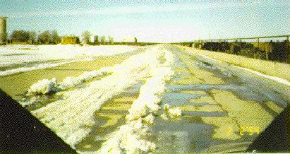
Recent photo of the remains of the Pampa ramp.
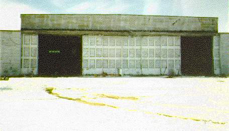
Recent photo of a remaining hangar at Pampa.
Scott Murdock visited the site of Pampa AAF in 2003, and reported that "Most of the airfield is fenced off & used for farming.
The runway patterns are faintly visible in aerial photos, but the ground is now farmland.
The most obvious remnant of AAF use is the concrete water tower."
A 2003 Army Corps of Engineers diagram of the WW2-era property boundaries of Pampa AAF.
The airfield at Pampa was not depicted at all (even as abandoned) on recent aeronautical charts or topo maps.
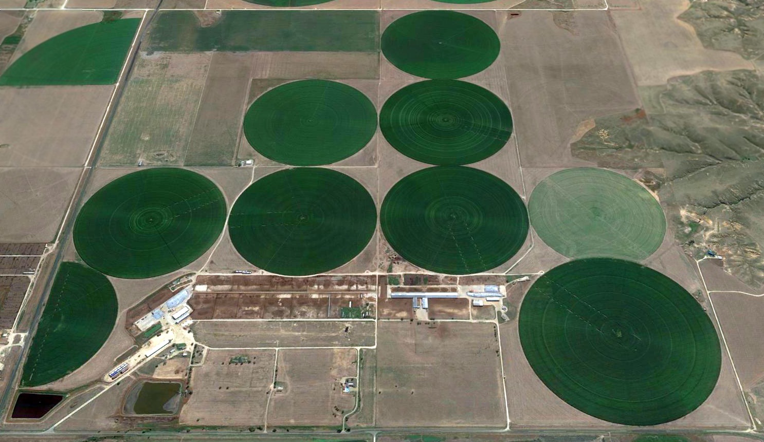
A 2016 aerial view looking east showed that further circular irrigated farming plots had erased the traces Pampa AAF's runways,
but portions of the paved ramp area & the street grid still remained recognizable.
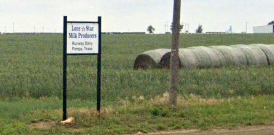
A 2023 photo looking northeast showed the history of the Pampa AAF site is commemorated by the name of the “Runway Dairy” that occupies the property.
The remnants of Pampa AAF are located southeast of the intersection of Route 152 & Ranch Road 1474.
See also:
A historical description from the Handbook of Texas Online.
A 1996 Army Corps of Engineers Project Fact Sheet.
A 1994 Army Corps of Engineers Ordnance & Explosives report.
____________________________________________________
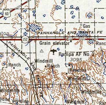
Reeves Auxiliary Army Airfield #1 / Pampa Air Force Auxiliary Airfield #2, Pampa, TX
35.45, -100.98 (Northeast of Amarillo, TX)
A 10/13/43 aerial view looking north at “Pampa Army Air Field Auxiliary #1 (Reeves Field)”
from the 1945 AAF Airfield Directory (courtesy of Scott Murdock).
This field was built during WW2 as one of 4 satellite fields for Pampa AAF (13 miles northeast),
which conducted advanced twin-engine training in AT-10s, AT-9s, B-25s, and AT-17s.
The dates of construction of Pampa Auxiliary #1 has not been determined,
but the parent field became operational in 1942.
A 5/15/43 AAF list of airfields of the Gulf Coast Training Center (courtesy of Ron Plante)
described Pampa Auxiliary #1 as having 3 asphalt 4,500' runways.
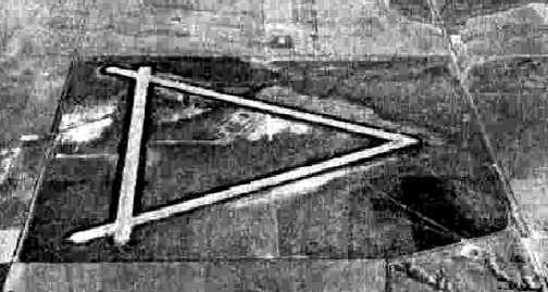
The earliest depiction which has been located of Pampa Aux #1
was a 10/13/43 aerial view from the 1945 AAF Airfield Directory (courtesy of Scott Murdock).
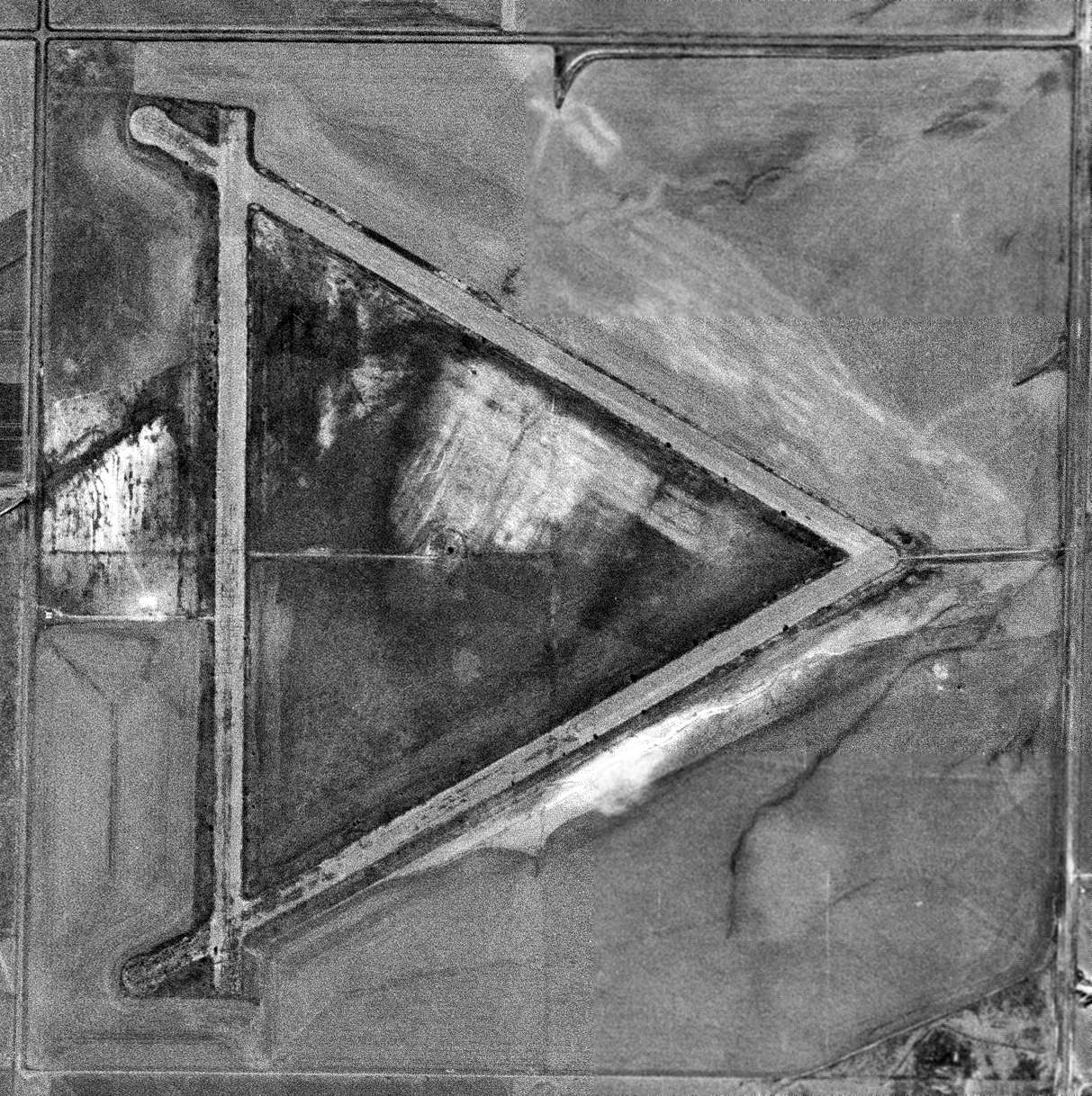
It depicted the field as consisting of 3 paved runways in a triangular layout.
No buildings or other improvements were visible.
Pampa Auxiliary #1 was not yet depicted on the August 1944 OK City Sectional Chart.
The earliest aeronautical chart depiction which has been located of Reeves Aux #1 was on the October 1945 Oklahoma City Sectional Chart (courtesy of John Voss),
which depicted Reeves #1 along with Pampa AAF & its other satellite fields.
The 1945 AAF Airfield Directory (courtesy of Scott Murdock) described “Pampa Army Air Field Auxiliary #1 (Reeves Field)”
as a 640 acre square-shaped property within which were 3 bituminous 4,500' runways,
oriented north/south, northeast/southwest, and northwest/southeast.
The field was said to not have any hangars,
to be owned by the U.S. Government, and operated by the Army Air Forces.
However, the title of the listing described the field as Inactive.
Reeves #1 was still depicted on the September 1947 OK City Sectional Chart.
Following the creation of the USAF as an independent armed service,
this airfield was depicted as “Pampa AF #2” starting on the September 1948 OK City Sectional Chart.
Pampa AF #2 was depicted on the 1949 Oklahoma City Sectional Chart (courtesy of John Price) as having a 4,500' paved runway.
Pampa AF Auxiliary #2 stayed on the books until at least 1952.
A 10/9/54 USGS aerial view showed Pampa AF #2 appeared to remain intact though deteriorated.
There did not appear to have been any hangars at the field.
The last aeronautical chart depiction which has been located of Pampa AF #2 was on the March 1956 Oklahoma City Sectional Chart.
It depicted Pampa AF #2 as having a 4,500' paved runway, but also indicated “Emergency use only”, which evidently foreshadowed the airfield's abandonment later that year.
Pampa AF #2 was evidently abandoned at some point in 1956,
as it was no longer depicted at all on the September 1956 OK City Sectional Chart.
Two 1994 views of the site of Pampa AF #2.
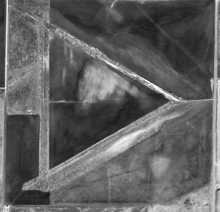
As seen in the 1996 USGS aerial photo, the Pampa AF #2 airfield consisted of three 4,200' runways,
which have deteriorated greatly but were still plainly discernible.
Scott Murdock visited the site of Pampa AF #2 in 2003, and reported that "The airfield is now farmed.
Aerial photos still show the runway patterns, though I could not discern them from ground level."
The Pampa AF #2 airfield was no longer depicted at all (even as abandoned) on recent aeronautical charts or USGS topo maps.
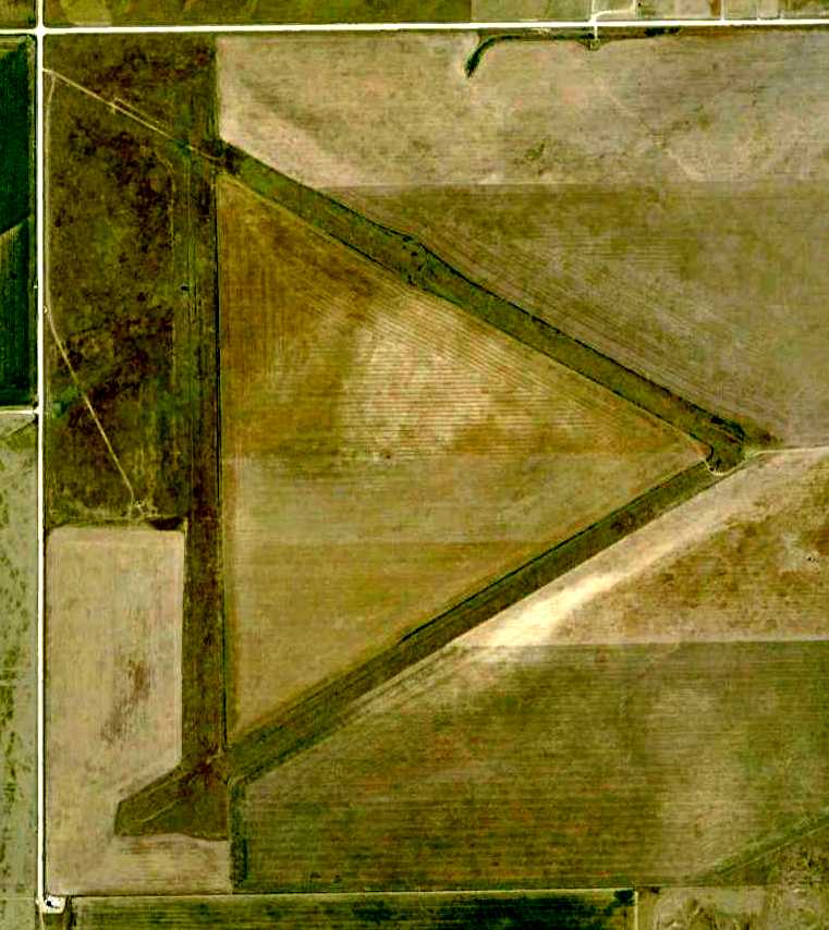
A 4/1/08 aerial photo showed the 3 runways of Pampa AF #2 remained quite recognizable.
The site of Pampa AF #2 airfield is located along the west side of Route 70, 6 miles south of the town of Pampa.
See also:
A 1996 Army Corps of Engineers Project Fact Sheet.
A 1994 Army Corps of Engineers Ordnance & Explosives report.
____________________________________________________
Since this site was first put on the web in 1999, its popularity has grown tremendously.
If the total quantity of material on this site is to continue to grow,
it will require ever-increasing funding to pay its expenses.
Therefore, I request financial contributions from site visitors,
to help defray the increasing costs of the site
and ensure that it continues to be available & to grow.
What would you pay for a good aviation magazine, or a good aviation book?
Please consider a donation of an equivalent amount, at the least.
This site is not supported by commercial advertising –
it is purely supported by donations.
If you enjoy the site, and would like to make a financial contribution,
you
may use a credit card via
![]() :
:
Please consider checking the box to make a monthly donatation.
For a mailing address to send a check, please contact me at: paulandterryfreeman@gmail.com
If you enjoy this web site, please support it with a financial contribution.
please contact me at: paulandterryfreeman@gmail.com
If you enjoy this web site, please support it with a financial contribution.
____________________________________________________
This site covers airfields in all 50 states.