Abandoned & Little-Known Airfields:
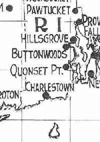
Rhode Island
© 2002, © 2024 by Paul Freeman. Revised 7/20/24.
This site covers airfields in all 50 states: Click here for the site's main menu.
____________________________________________________
Please consider a financial contribution to support the continued growth & operation of this site.
Charlestown Airport / Atlantic Airport (revised 10/31/23 - Charlestown NAAS (revised 5/7/22) - Coventry Air Park (revised 5/7/22)
Heritage Heliport / Providence Downtown Helistop (added 1/14/21) - Newport Naval Air Facility / Gould Island Seaplane Base (revised 7/20/24)
Pothier Field / Buttonwoods Flying Field (revised 8/14/20) - Smithfield Airport (added 12/5/20)
____________________________________________________
Heritage Heliport / Providence Downtown Helistop (RI9), Providence, RI
41.821, -71.405 (Southwest of Boston, MA)
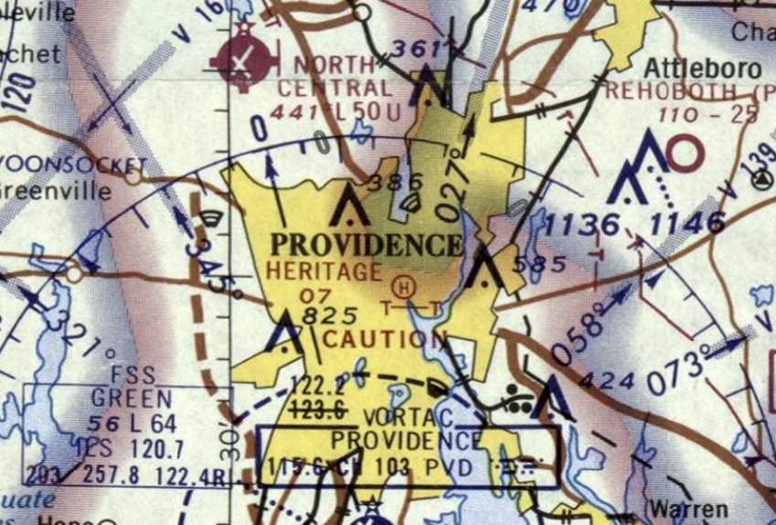
Heritage Heliport, as depicted on the March 1970 Boston Sectional Chart.
According an article in the 1/23/16 Providence Journal, Providence's downtown heliport was created in 1969.
This heliport was not yet depicted on the 1969 Boston Sectional Chart.
The earliest depiction which has been located of Heritage Heliport was on the March 1970 Boston Sectional Chart.
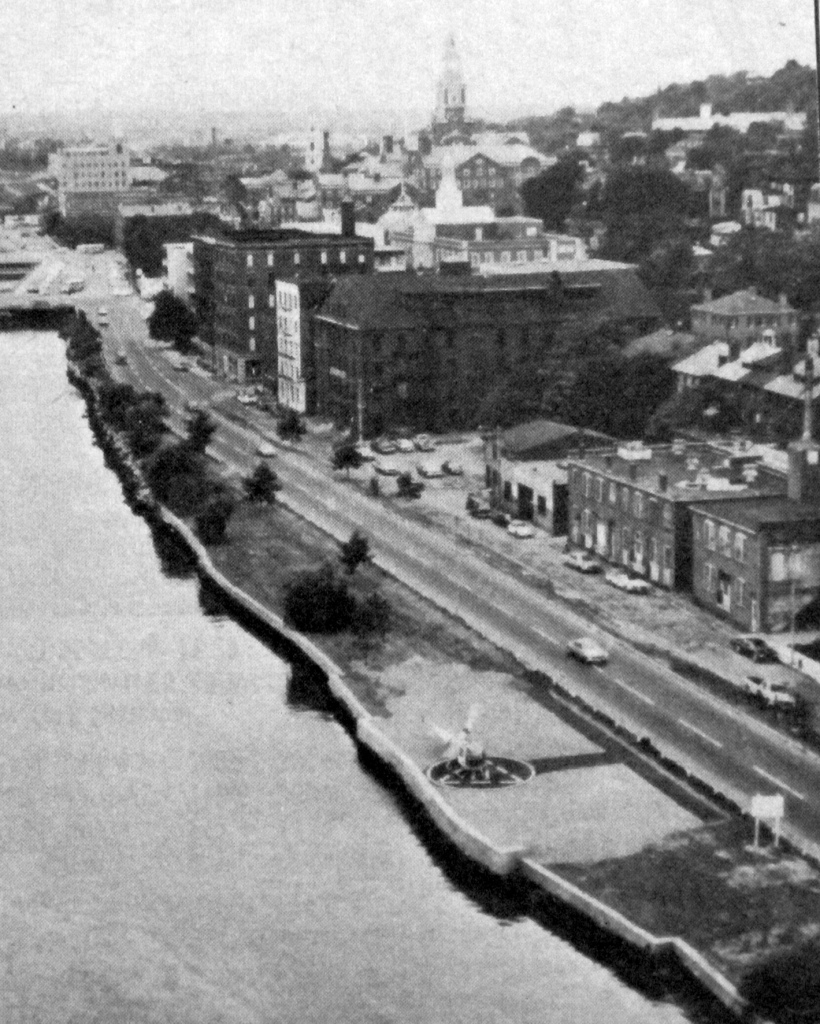
The earliest photo which has been located of Providence Downtown Helistop was an undated aerial view looking north from the 1972 Flight Handbook (courtesy of Jonathan Westerling).
It described Providence Downtown Helistop as a 24' square asphalt pad, squeezed into a narrow plot in between the Providence River & South Water Street.
A single-engine light helicopter was pictured on the helipad, which was described as unattended & state-owned.
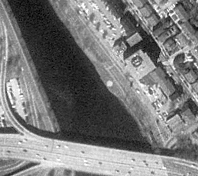
A 1995 aerial view of the Providence Downtown Helistop.
According an article in the 1/23/16 Providence Journal, “the Downtown Providence Helistop, the state-owned, 25' wide concrete pad
on the east bank of the Providence River handled around 50 chopper landings per year.
Jim Warcup, aeronautics inspector with the Rhode Island Airport Corporation, and the man responsible for managing the helistop when it was active,
said parents of Brown University students & executives from Textron were the most frequent users.
Other users ranged from the NY Department to movie companies shooting in Providence.”
The article continued, “The I-195 Redevelopment District Commission unwittingly bought the pad & was responsible for closing it.
Tasked with redeveloping the land freed by the relocation of Route 195, the commission was unaware that there was a Providence helipad
before it acquired the roughly 40 acres of land from the RI Department of Transportation.
When the commissioners learned they owned a helipad, Executive Director Jan Brodie said she was concerned about exposing the land panel to legal liability.
The helipad was quietly decommissioned in 2014, and a sculpture named 'Panoply' was installed in fall 2014.”
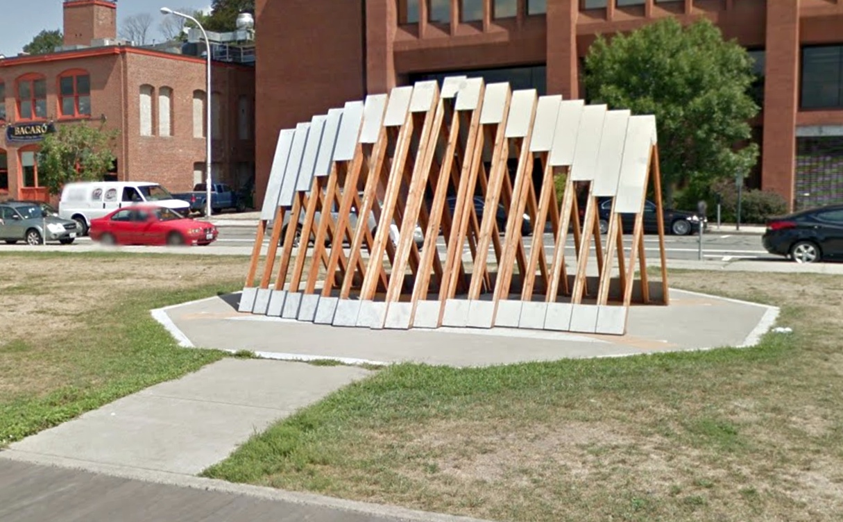
A 2015 photo looking northeast showed the sculpture which had been placed atop the Providence Downtown Helistop, ensuring it would not be used for any further helicopter operations.

An undated photo from a 2016 article looking northwest at the sculpture which had been placed atop the Providence Downtown Helistop.
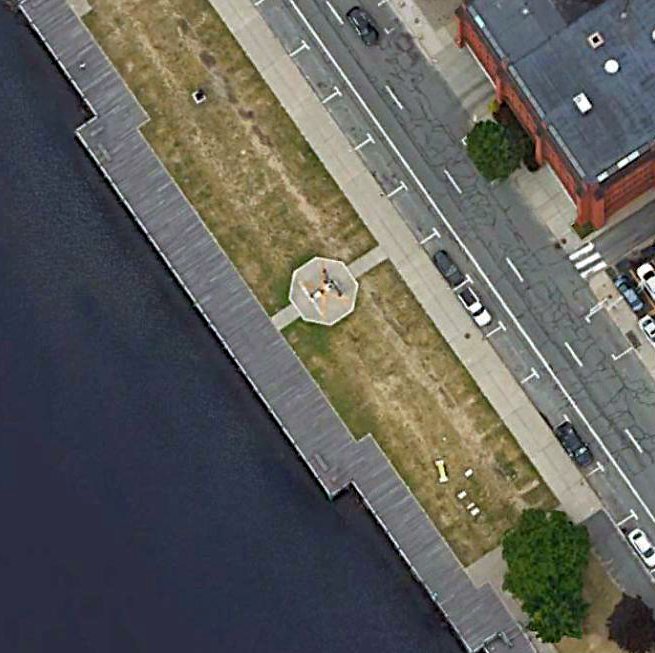
A 2018 aerial view of the Providence Downtown Helistop.
Thanks to Jonathan Westerling for pointing out this airfield.
____________________________________________________
Smithfield Airport, Smithfield, RI
41.921, -71.539 (Southwest of Boston, MA)
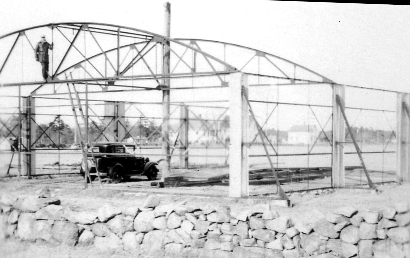
A circa 1932 photo of the Smithfield Airport hangar under construction.
According to the Krupp Library Newsletter (courtesy of James Hanson),
“In 1932 John Emin constructed a runway for his 2-seat Curtiss Pusher by clearing a cornfield on his farm.
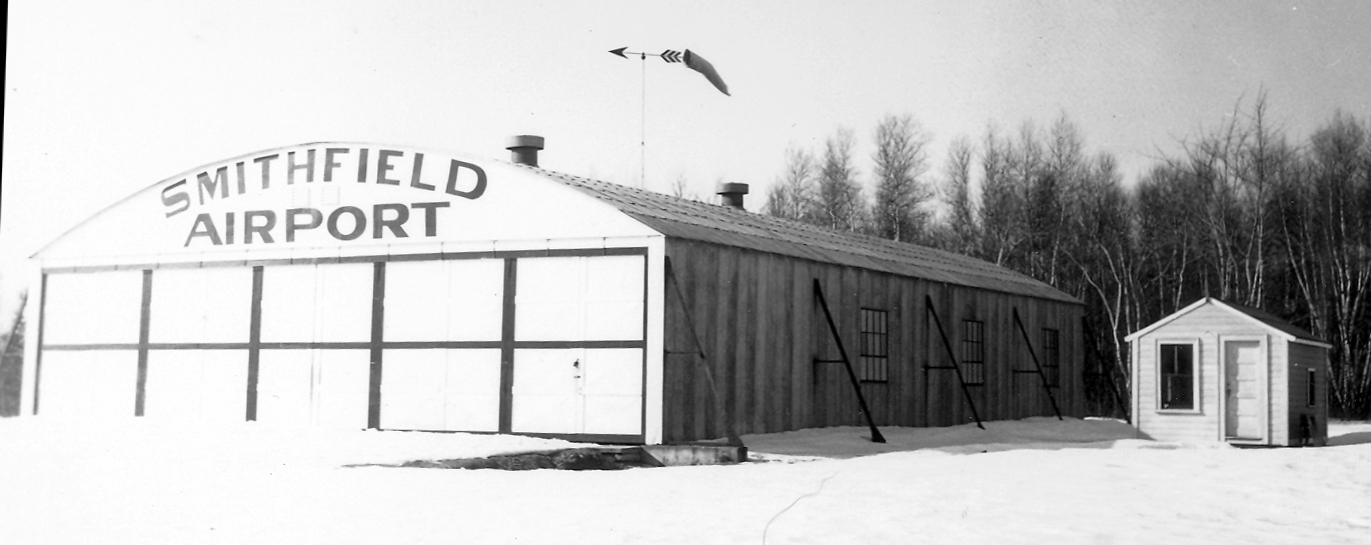
Emin constructed a hangar & painted 'Smithfield Airport' on the building & voila an airport was born.
The hangar was located on the [current-day] site of the green facilities building behind the Chase Wellness Center.
The airport consisted of the hangar, a grassy airstrip & a colorful windsock to guide planes.”
The earliest photo which has been located of Smithfield Airport was a circa 1932 photo of its hangar under construction.
However, Smithfield Airport was not yet depicted on the August 1933 Boston Sectional Chart.
The earliest aeronautical chart depiction which has been located of Smithfield Airport was on the December 1934 Boston Sectional Chart,
which depicted Smithfield as a commercial/municipal airport.
A circa 1930s winter photo of the Smithfield Airport hangar & another small building.
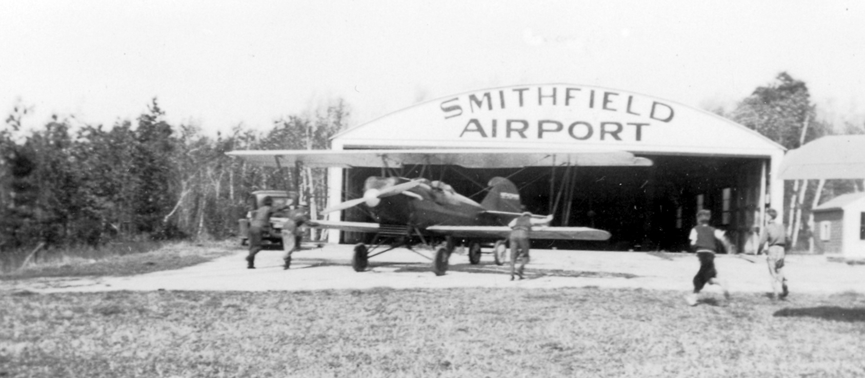
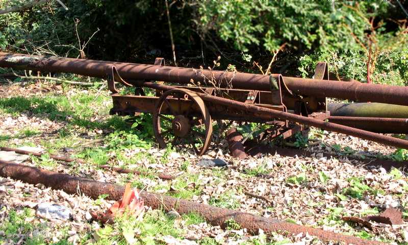
The only photo which has been located showing an aircraft at Smithfield Airport was a circa 1930s photo of what appears to be a Travelaire 2000 biplane being pushed back into its hangar.
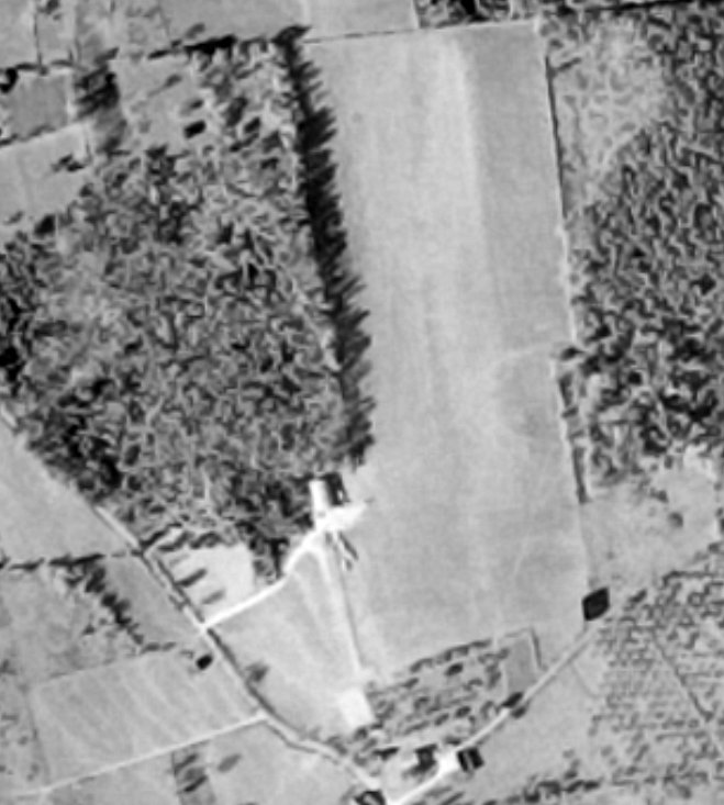
A 10/17/41 USGS aerial view (courtesy of Lee Corbin) showed Smithfield Airport as having an unpaved north/south runway, with a hangar on the southwest side.
There were no aircraft visible or any other indication of recent aviation use.
Smithfield Airport was no longer depicted on the 1943 USGS topo map.
The larger North Central State Airport opened in December 1951 a few miles to the east,
eventually replacing Smithfield Airport.
The last chart depiction which has been located of Smithfield Airport was on the May 1955 Boston Sectional Chart,
which depicted Smithfield as having an 1,800' unpaved runway.
According to the Krupp Library Newsletter (courtesy of James Hanson),
“The Smithfield Airport remained operational until the mid-1950s.”
Smithfield Airport was evidently closed at some point in 1955,
as it was no longer depicted on the November 1955 Boston Sectional Chart.
The only topo map depiction which has been located of Smithfield Airport was on the 1958 USGS topo map (courtesy of Lee Corbin).
Note that it depicted Smithfield Airport in a slightly different location than the aeronautical charts, which may have been due to a lack of precision rather than a truly different location.
A 1963 aerial photo showed the former Smithfield Airport hangar remained on the north side of an open grass field,
but there was no sign of any recent aviation use.
According to Wikipedia, “In October 1967, Earl Tupper, alumnus & inventor of Tupperware, donated his 428-acre hillside estate to Bryant College for the creation of the new campus.”
A 1970 photo showed the former hangar had been removed at some point between 1963-70,
and land had been cleared for construction of the new college campus, erasing the last traces of Smithfield Airport.
According to the Krupp Library Newsletter (courtesy of James Hanson),
“Bryant’s campus moved from Providence to Smithfield in September 1971.”
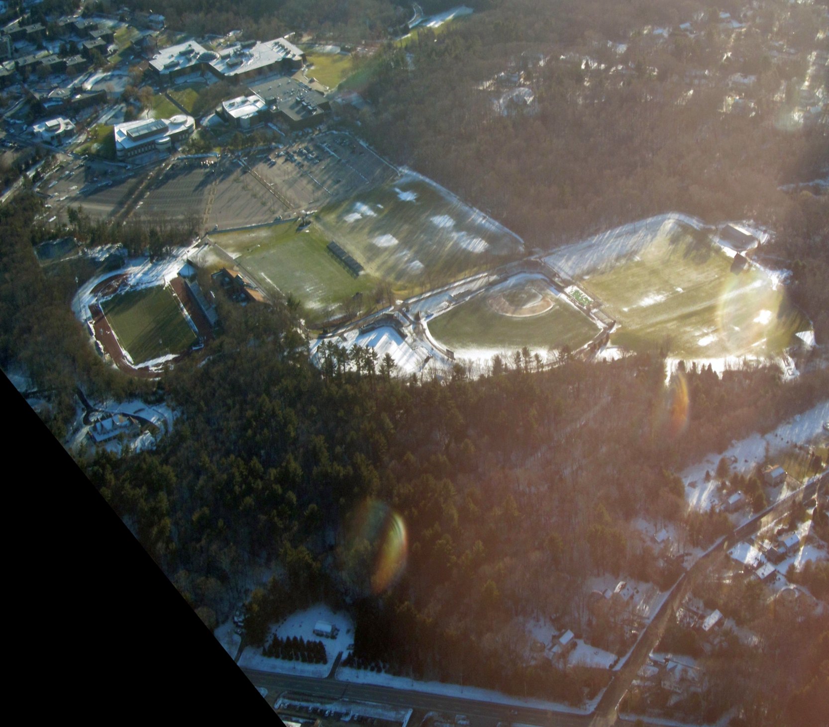
A 12/28/12 aerial view by Graeme Smith looking east the site of Smithfield Airport, now occupied by athletic fields on the campus of Bryant University,
with no trace remaining of the little airport.
Thanks to Chris Kennedy, Graeme Semith, James Hanson, Gary Lampman, and Lee Cobrin for information about this airfield.
____________________________________________________
Coventry Air Park, Coventry, RI
41.69, -71.583 (Southwest of Boston, MA)
Coventry Air Park, as depicted on the July 1947 Boston Sectional Chart.
This small general aviation airport was evidently established at some point in 1947,
as it was not yet depicted on the January 1947 Boston Sectional Chart.
The earliest depiction which has been located of Coventry Air Park was on the July 1947 Boston Sectional Chart,
which depicted Coventry as an auxiliary airfield.
The 1955 Boston Sectional Chart depicted Coventry Air Park as having a 1,800' unpaved runway.
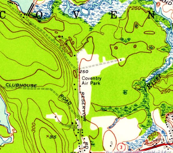
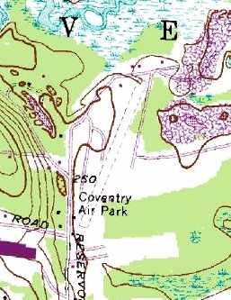
The 1955 USGS topo map depicted Coventry Air Park as an L-shaped clearing with 1 small building along the west side.
Bob Farrell recalled, “In 1955-57 I had a J-5 Cub at Coventry Air Park.
Another VS-31 pilot, Carl Morton, and I flew charters out of there to Nantucket & Marthas’ Vineyard.
Another VS-31 pilot Nate Mayo had a Waco UPF-7 there. He was aerobatic nut.”
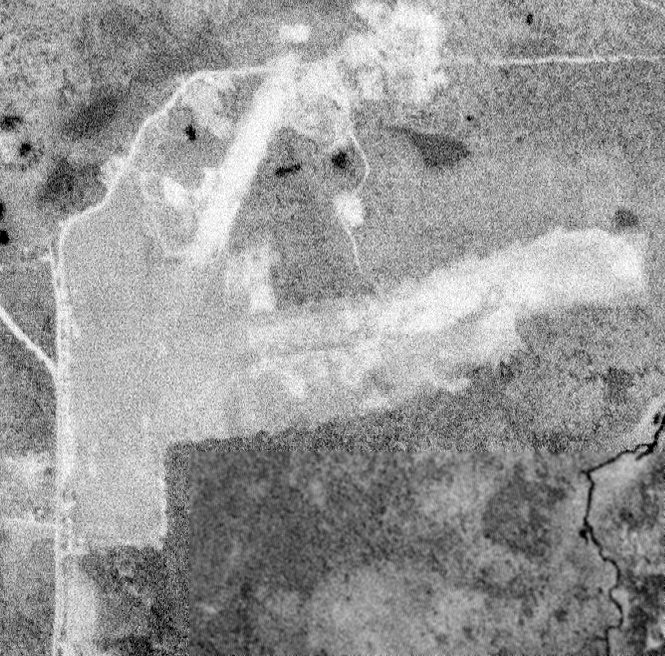
The earliest photo which has been located of Coventry Air Park was a 5/5/60 USGS aerial view,
which depicted Coventry as having 2 or 3 grass runways.
A 1963 aerial photo depicted several light single-engine aircraft parked along the southern edge of Coventry Air Park.
According to an article in the Coventry Patch, “With expansive, flat terrain & manicured turf the area provided an ideal location for single-engine prop planes to land & take off.
The privately-owned airpark was used by local aeronautical enthusiasts & others from as far away as NY & CT.
Some pilots also offered lessons & used the airpark to provide hands-on training in the art & science of flying a plane.
During the airpark’s heyday mobile homes ringed the perimeter of the field.
Coventry resident Reginald Oliver who owned a television repair business recalled visiting several clients who proudly kept their Cessna or Piper Cubs parked in their driveway.
The ability to literally take off & land your plane within a hundred yards of your home was a novelty & a real treat for those fortunate enough to do so.”
The 1965 Boston Sectional Chart depicted Coventry as having a 3,000' unpaved runway – significantly longer than as depicted a decade before.
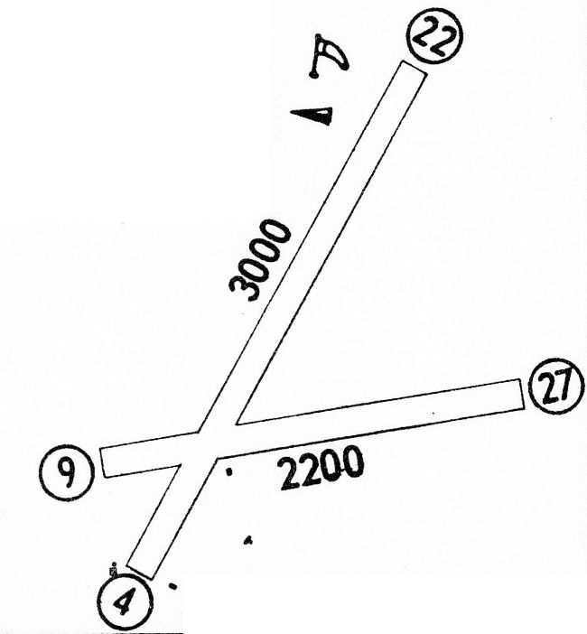
The 1968 Flight Guide (courtesy of Robert Levittan) depicted Coventry Air Park as having 2 unpaved runways, with 3 small building to the south of the runway intersection.
The only photo which has been located showing aircraft at Coventry Air Park was a 3/10/70 USGS aerial view,
which depicted 3 single-engine aircraft parked on the southwest side.
Trailers & houses had been built all along its west side, which would eventually spell the end for this little airport.
The last aeronautical chart depiction which has been located of Coventry Air Park was on the June 1973 NY Sectional Chart (courtesy of Ron Plante).
It depicted Coventry as having a 2,800' unpaved runway.
The last depiction which has been located of Coventry Air Park was on the 1975 USGS topo map,
which depicted Coventry Air Park as having a single unpaved northeast/southwest runway & 1 small building along the west side.
Coventry Air Park was evidently closed at some point between 1973-79,
as it was no longer depicted on the December 1979 Boston Sectional Chart (courtesy of Ron Plante).
According to an article in the Coventry Patch, “The sentimental value as an airfield was eventually eclipsed by its potential worth as a marketable property
and before long the planes disappeared, streets were paved & the entire site was transformed into a residential community of modular homes now called Westwood Estates.”
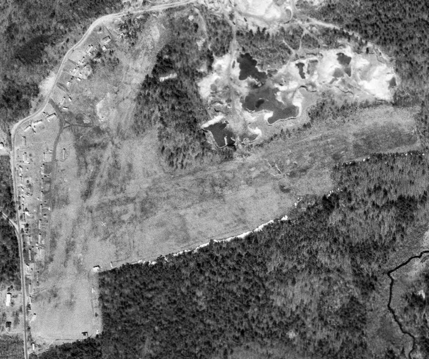
A 1995 aerial photo depicted houses covering the site of Coventry Air Park.
A 2012 aerial view show the overall property outline of Coventry Air Park remained recognizable, even with houses covering the site.
As of 2015, the housing development at least commemorates the site of Coventry Air Park
with street names like Valiant Drive, Wright Way, Kitty Hawk Lane, and Lear Drive.
Thanks to Bob Farrell for pointing out this airfield.
____________________________________________________
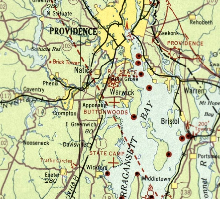
Pothier Field / Buttonwoods Flying Field, Buttonwoods, RI
41.698, -71.426 (East of Westerly, RI)

A circa 1920s photo of George Armitage's biplane (model unidentified) in front of a hangar marked “Pothier Flying Field” (courtesy of George's great-granddaughter Kim Armitage Hetland).
The earliest dated reference which has been located to Pothier Field was in the Summer 2007 American Aviation Historical Society Journal,
which said as of 1928, “On the north shore of Greenwich Bay, in Warwick near Nausauket, there was a flying field known as Pothier Field,
at the summer community of Buttonwoods, about 8 miles south of the city of Providence.
It is a small community of beach cottages, small year-round homes mixed in with a few larger well-maintained residences.
Pothier was named after former Governor of Rhode Island, Aram Pothier,
and had one hangar in 1928, as seen in photographs, showing a Bourdon Kitty Hawk sport biplane there at that time.”
The earliest depiction which has been located of Pothier Field was a circa 1920s photo of George Armitage's biplane (model unidentified)
in front of a hangar marked “Pothier Flying Field” (courtesy of George's great-granddaughter Kim Armitage Hetland).
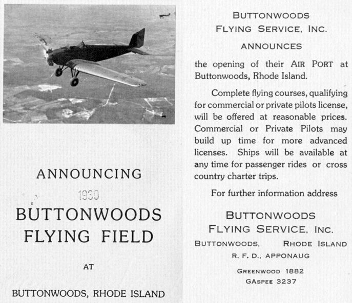
Pothier Field was evidently reopened in 1930 under a new name, “Buttonwoods Flying Field”, as announced in a 1930 brochure (courtesy of Tom Heitzman).
It described the services offered by Buttonwoods Flying Service Inc.
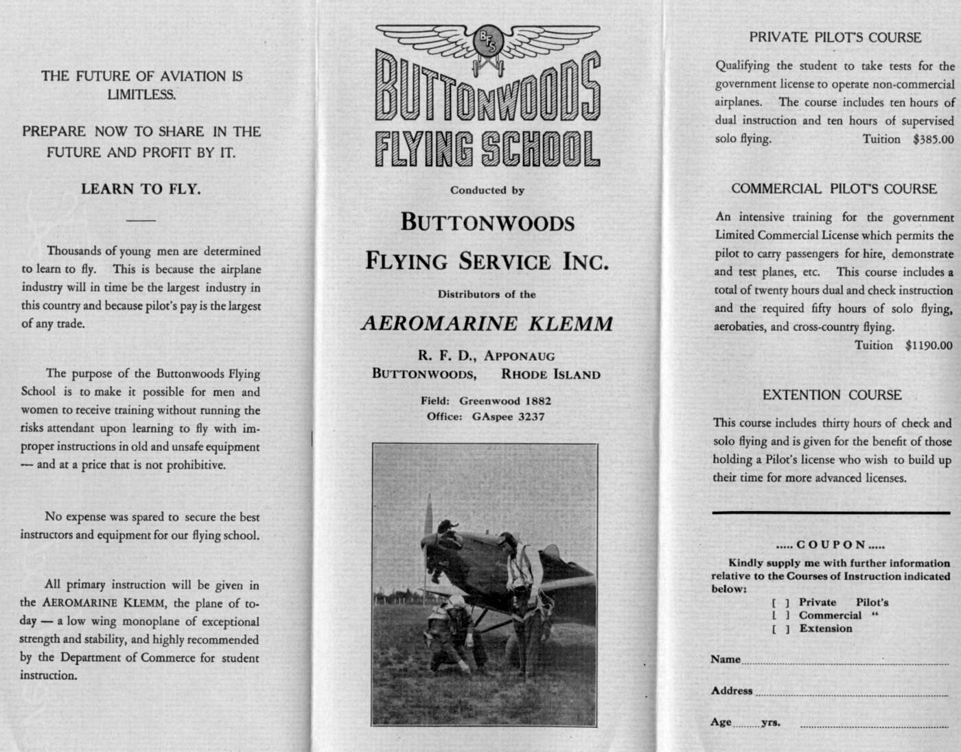
A circa 1930s brochure for the Buttonwoods Flying School (courtesy of Tom Heitzman).
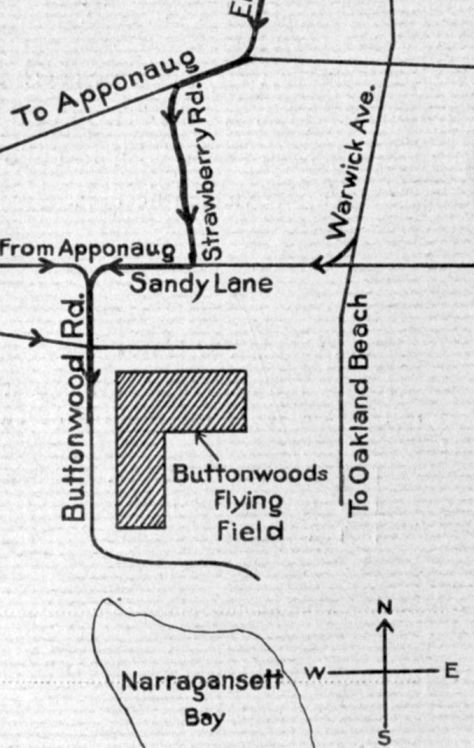
A circa 1930s map (courtesy of Tom Heitzman) depicted Buttonwoods Flying Field as an L-shaped property.
Buttonwoods Flying Field was not depicted on the 1931 USGS topo map.
The earliest aeronautical chart depiction which has been located of Buttonwoods Flying Field was on the March 1933 Boston Sectional Chart.
It depicted Buttonwoods as an auxiliary airfield.

The earliest aeronautical chart depiction which has been located of Buttonwoods Flying Field was on the August 1935 Boston Sectional Chart.
It depicted Buttonwoods as an auxiliary airfield.
Buttonwoods Flying Field evidently was closed (for reasons unknown) at some point between 1935-36,
as it was no longer depicted on the January 1936 Boston Sectional Chart.
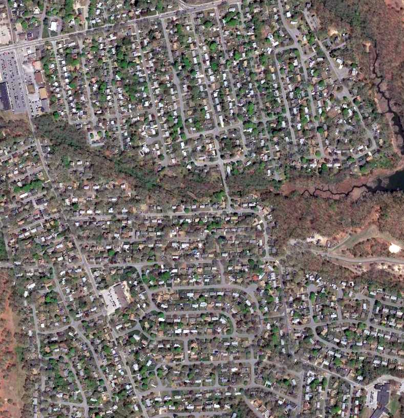
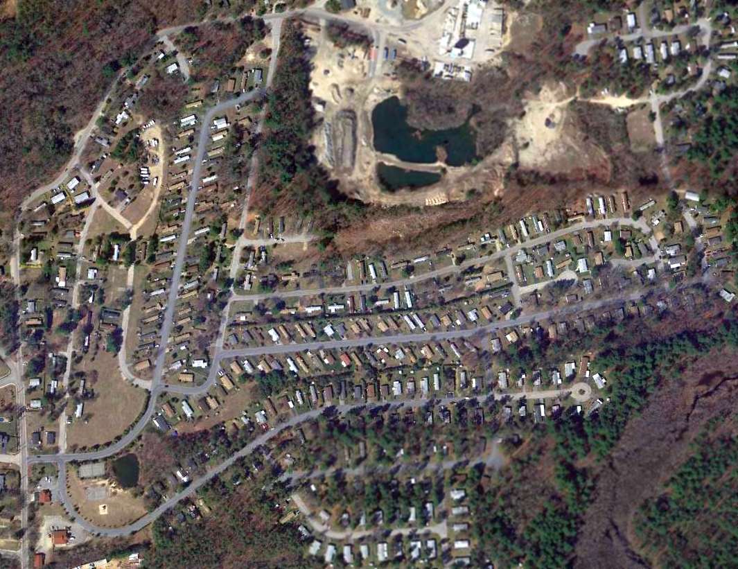
A 2015 aerial view shows no trace remaining of Buttonwoods Flying Field.
The site of Buttonwoods Flying Field is located southeast of the intersection of Buttonwoods Avenue & West Shore Road.
Thanks to Tom Heitzman for pointing out this airfield.
____________________________________________________
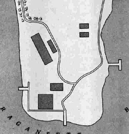
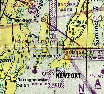
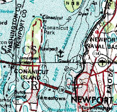
Newport Naval Air Facility, Gould Island, RI
41.532, -71.345 (Northwest of Newport, RI)
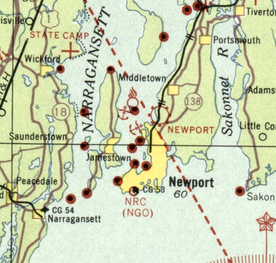
The Gould Island seaplane facility, as depicted on the March 1933 Boston Sectional Chart.
In 1909 the Federal Government purchased a portion of Gould Island,
a 56-acre tract located off Conanicut Island in the East Passage of Narragansett Bay.
The government then purchased the remainder of the island in 1918,
and the next year the Newport Naval Torpedo Station added a new storage facility on Gould Island.
In 1919, new construction on Gould Island by the Navy included Air Detail hangars for seaplanes & kite balloons,
a water tower & underground distribution lines, a wooden pier for personnel at the north end of the island,
and a concrete pier for torpedoes at the southeast point of the island.
The former Haughton family residence was converted to a barracks for the Marines who guarded the magazines.
During the next several years additional buildings were erected on the island
to provide torpedo & warhead storage as well as housing for a Marine detachment.
In 1920, a Naval Air Detail was established under Navy Lieutenant Thomas H. Murphy.
On 8/20/1921, two naval torpedo planes – modified by the addition of pontoons –
arrived at Gould Island, and were based at a newly built hangar of steel-frame & wood construction near the south end of the island.
A concrete platform & ramp were constructed, oriented toward the west.
The aircraft were to be employed to test-drop aerial torpedoes.
They were subsequently used to track & locate torpedoes that have been test-fired from a large barge
or, later, from the Firing Pier at the north end of Gould Island.
On 11/2/1921, Lieutenant Murphy, Head of the Air Detail, made the first successful U.S. air drop of a torpedo in the waters off Gould Island.
In 1931, hangars & ramps were constructed at the southern end of Gould Island.
The earliest depiction which has been located of the Gould Island seaplane facility was on the March 1933 Boston Sectional Chart.
It depicted the seaplane base (with an anchor symbol), but did not otherwise identify it.
On 9/21/38, a hurricane brought an estimated $17,900 of damage to the Navy installation on Gould Island.
As the winds built, 2 seaplanes were made fast outside, and all other planes were placed in the hangar.
The hangar doors were closed.
The tide rose around the hangar, and the area was swept by violent seas that broke in the east door of the hangar.
The hangar’s south windows were covered with water.
Shortly after 6:00 pm the seaplanes secured outside broke loose & drifted northward.
One plane was badly damaged & sank about one mile north of Gould Island.
Several days later, pieces of a seaplane’s main float & a small section of its fuselage
were recovered near Beavertail Lighthouse about 7 miles south of the point that the plane was last observed afloat.
The main doors of the hangar were carried away.
Nine planes were damaged to the extent that they required major overhauls.
In 1939, test drops began from Gould Island aircraft of a turbine-powered torpedo, originally of British design,
that will become the Mark 13 torpedo used by aircraft in World War II.
In 1939, the first production Douglas TBD-1 Devastator was fitted with a pair of floats,
and then sent to Gould Island for drop tests of the Mark 13 torpedo.
The earliest photo which has been located of the Gould Island seaplane facility
was a 1939 aerial view (from the RIGIS at the University of Rhode Island, via Chris Kennedy).
It depicted several seaplanes on a small ramp at the southwest corner of the island, with a single ramp leading into the water to the west.
The northern end of the island was still undeveloped.
Chris Kennedy observed, “You can almost read U. S. Navy on the hangar at the south end.
Note that the only seaplane ramp is west of the hangar. They must have added the other one later.”
In 1941, the newly constructed Naval Air Station at Quonset became the operational base for 4 squadrons of seaplanes,
and the Gould Island air facility was designated an auxiliary landing area.
From 1941-45, a total of 4,300 test drops of the Mark 13 torpedo were conducted in the waters east of Gould Island.
On 4/9/42 the Navy anti-aircraft gun crews who had manned four 1.1" quadruple-gun mounts on Gould Island
were relieved by the Army’s Battery A, 207th Coast Artillery (Anti-aircraft), Eastern Defense Command.
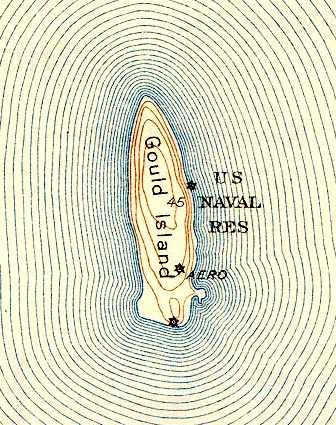
The 1942 USGS topo map depicted the “U.S. Naval Reservation” on Gould Island, and an “Aero” beacon,
but did not depict any of the seaplane facilities.
In 1942, construction began for a new hangar & a larger, south-facing ramp for the air facility at the south end of Gould Island.
The new ramp was 50' wide & 350' long, with a slope of 6 degrees. It extended 10' below the low-tide level.
The November 1942 Boston Sectional Chart (courtesy of Chris Kennedy) depicted the seaplane facility as the “Naval Air Depot”.
In April 1943, the Army’s Battery A, 207th Coast Artillery (Anti-aircraft) was relieved by the 701st Coast Artillery Regiment (Anti-aircraft).
In April 1943, construction of the aircraft hangar at the south end of the island was completed.
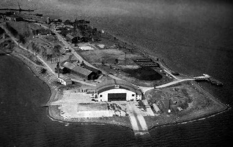
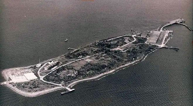
A circa 1940s aerial view looking north at the Newport Naval Air Facility on Gould Island (National Archives).
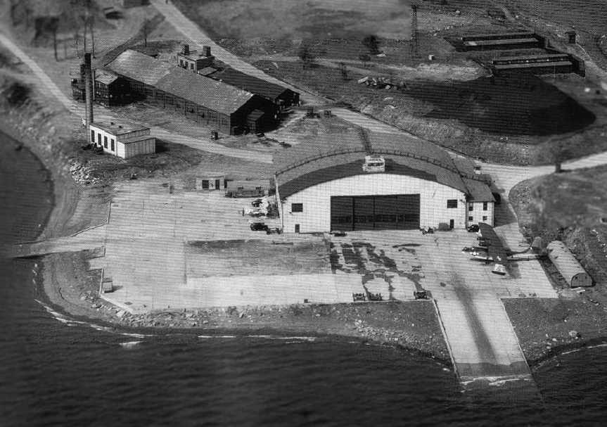
A closeup from the circa 1940s aerial view looking north, showing the Gould Island ramp & hangar, the airway beacon tower behind the hangar,
and a rare PBN Nomad on the right side of the ramp (National Archives).
John Voss reported, “The Nomad was a variant of the PBY-5 Catalina that was built by the Naval Aircraft Factory in Philadelphia, PA.
Only 156 were built most of which were given to the Russians under Lend Lease.
The USN retained about 20 or so for evaluation purposes (never used operationally).
The PBN differed from the PBY in that it had a revised hull, revised wing tip floats,
a very unique nose turret, a pointed nose, longer fuselage & tall tail.
The tall tail design feature was picked up by the PBY-6A & PB2B-2 Catalinas.
All PBN's were flying boats [non-amphibious]. Photographs of PBN's in USN markings are very rare.
No PBN's are existent in the US [as of 2005] as most were scrapped prior to the end of WWII. Do any remain in Russia? ...Time will tell.”
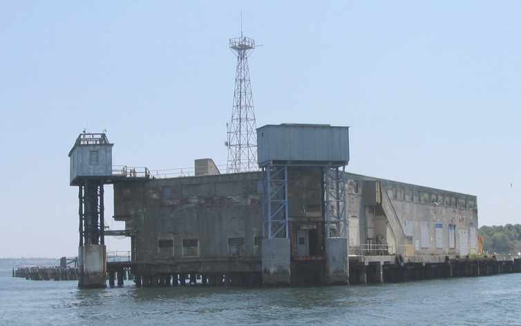
In October 1943, construction of the Firing Pier & the adjacent overhaul shop at the northern tip of Gould Island was completed.
The Firing Pier had 4 torpedo tubes for firing torpedoes, 2 for test-firing surface-ship torpedoes,
and 2, on elevators that lowered into the water, for test-firing submarine-launched torpedoes.
By the end of World War II, over 65,000 torpedo test-firings had been made from its launchers.
At the peak of aviation activity in 1944, the Air Detail included 11 officers, 119 men, and 26 planes.
According to the book “U.S. Naval Air Stations of WW2” by Mel Shettle, “Aircraft based at Gould Island during 1945
consisted of 5 OS2U Kingfishers, 3 N3N floatplanes, and one J4F Widgeon.”
In 1945 the Air Detail was renamed the “Naval Air Facility”.
The 1945 AAF Airfield Directory (courtesy of Scott Murdock) described Newport Naval Air Facility
as having a single 156' x 122' hangar on the south shore of the island.
It was said to be owned by the U.S. Government & operated by the Navy.
The December 1945 Boston Sectional Chart (courtesy of Chris Kennedy)
depicted the seaplane base on Gould Island as the “Naval Air Depot”.
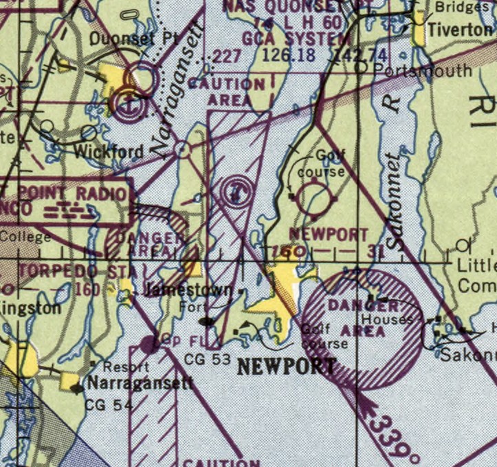
The last aeronautical chart depiction which has been located of the Gould Island seaplane base was on the January 1950 Boston Sectional Chart.
In 1951 the Torpedo Test Facility on Gould Island became part of the Naval Ordnance Station at Coddington Cove,
which had succeeded the former Naval Torpedo Station on Goat Island.
In a 1951 aerial view of the Newport NAF (from the RIGIS at the University of Rhode Island, via Chris Kennedy),
the torpedo test station is visible at the north end of the island.
The seaplane facility at the south end appears to have been closed by this point, as there are no aircraft visible on the island.
Herbert Fahr recalled, “I reported fresh out of boot camp as a Fireman Apprentice
to the US Naval Underwater Ordinance Station, Gould Island in December, 1952. I was there till March 1954.
There was a small group of airdales still there but I never saw a plane land or come up the ramp to the hangar.”
The Gould Island seaplane facility was no longer depicted at on the May 1953 Boston Sectional Chart.
The seaplane facility appeared abandoned but intact in a 1963 aerial photo.
The 1969 USGS topo map still depicted a seaplane base (the anchor symbol) at Gould Island,
but its depiction as such on a USGS topo map doesn't necessarily indicate it was still in operation at that point.
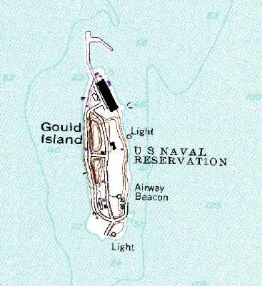
The 1975 USGS topo map still depicted Gould Island as a “U.S. Naval Reservation”,
as well as having an Airway Beacon along the southeast side.
The large firing pier building was depicted on the north side of the island,
but neither the seaplane ramp nor the hangar was still depicted on the south side of the island.
The hangar had evidently been removed at some point between 1951-75.
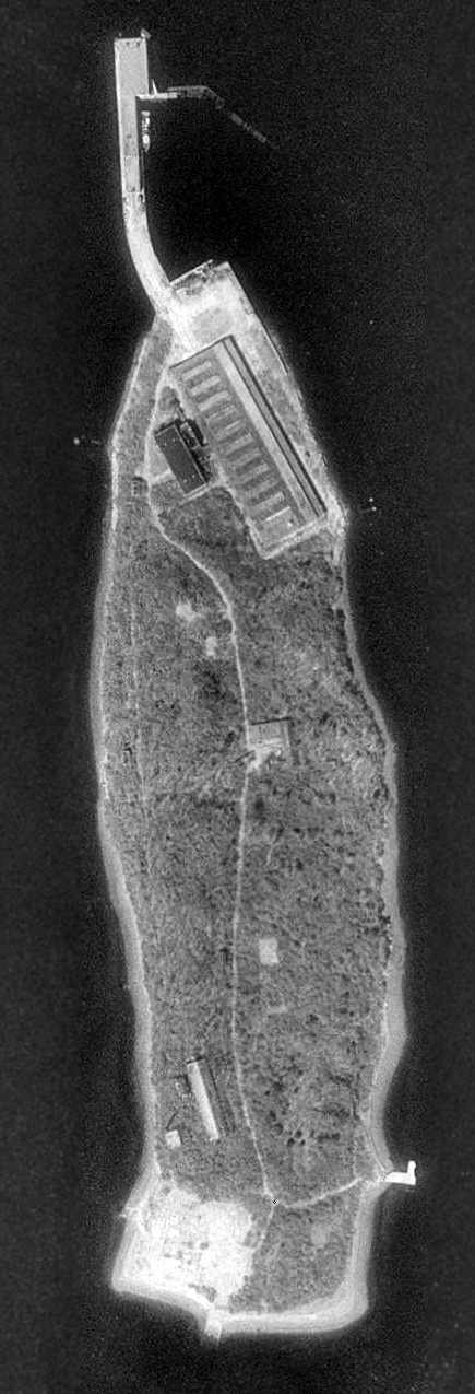
A circa 1970s aerial view looking northwest at Gould Island after the seaplane hangar had been removed.
In 1975 the Navy began transferring the southern 70% (about 39 acres) of Gould Island to the State of Rhode Island.
The State gained ownership of 17 acres in 1975 & 22 acres in 1989.
Within the northern area administered by the Navy,
four buildings were declared “historic” by the Navy & the Rhode Island Historical Preservation & Heritage Commission.
The 1995 USGS aerial photo of Gould Island depicted 2 large buildings at the Firing Pier on the north side of the island.
On the south side of the island, the concrete seaplane apron was still extant, but the hangar had evidently been removed at some point between 1963-95.
According to 1995 book “U.S. Naval Air Stations of WW2” by Mel Shettle,
“Gould Island is now the property of the State of Rhode Island.
Plans are to create a park on the island, although funds are lacking.”
In June 1999, although the Navy & the Rhode Island Historical Preservation & Heritage Commission
had previously designated 4 of the remaining Navy buildings to be historic, the Navy decided to demolish these 4 buildings.
It intermittently continued to test-fire torpedoes from the firing pier.
In 2000 & 2001, the 4 Navy structures within the roughly 17 acres that were still Navy property were torn down.
These buildings were the overhaul shop, the power plant, the acetylene building, and the upper 2 floors of the firing pier.
The rest of the firing pier was retained.
In 2003, as part of the agreement to demolish the four historic structures,
the Navy agreed to develop a display that depicts the history of the Gould Island Facility
in order to provide the public with a knowledge of the significance of the facility
and its importance to the war effort during World War II.
That display was on exhibit at the Naval War College Museum as of 2003.
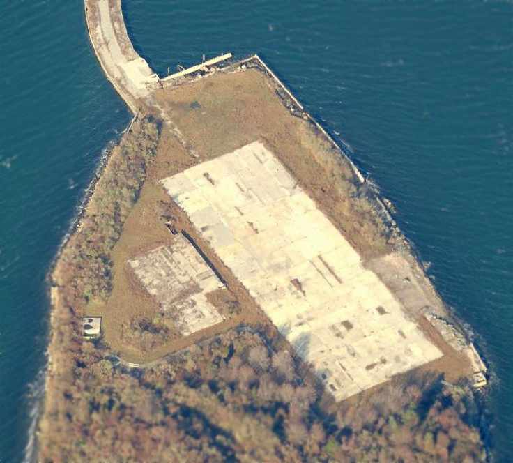
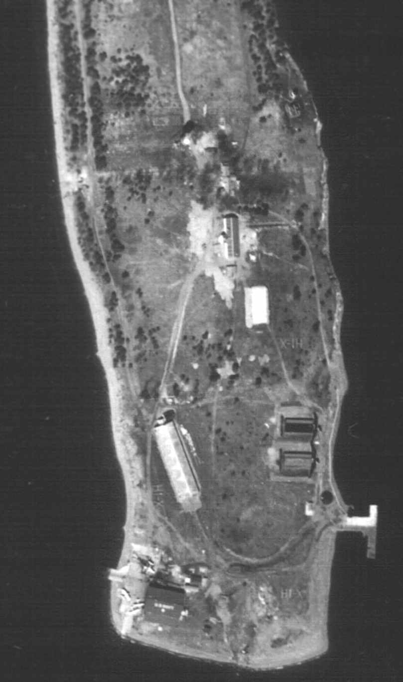
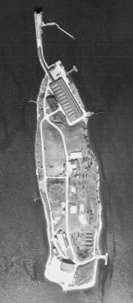
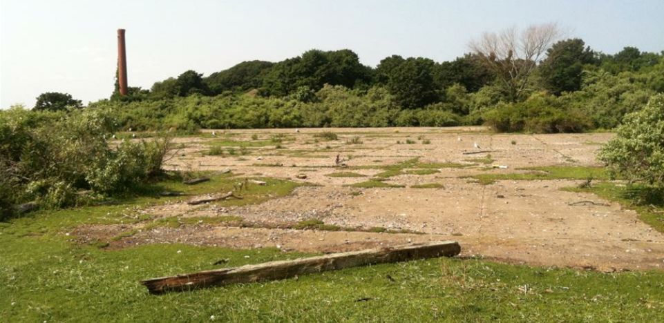
A circa 2005 aerial view looking north at the concrete foundation on the north side of Gould Island,
showing that all of the buildings of the Firing Pier had been removed.
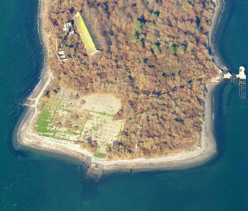
A circa 2005 aerial view looking north at the south end of Gould Island,
showing that the concrete seaplane apron remains, along with both ramps leading down into the water.
The hangar no longer stands, but a large 1940-vintage building still exists just north of the apron, along with a brick smokestack.
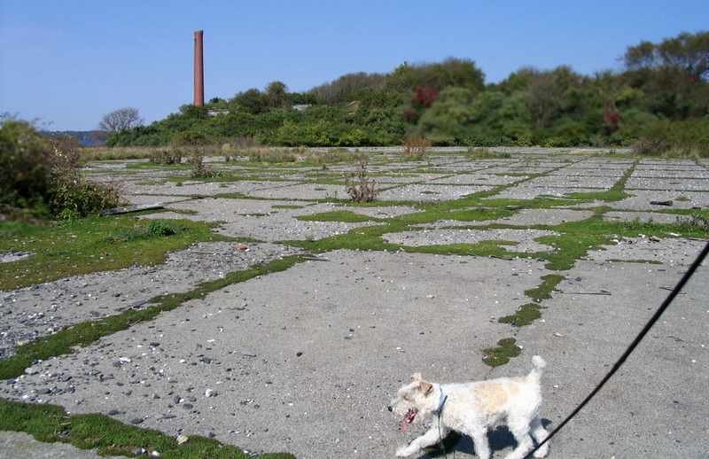
A 2006 photo by George DiGregorio looking north at the remains of the Gould Island seaplane apron.
George DiGregorio reported in 2006, “I recently took a little adventure out to explore the abandoned seaplane / torpedo base on Gould Island.
Its still pretty much like the 2005 aerial pictures.
The interior of the island is severely overgrown & impassable with 15' high thorny brambles
that choke off the island's interior so I was not able to visit any of the buildings.”
A 2006 photo by George DiGregorio looking southeast along the former Gould Island seaplane ramp.
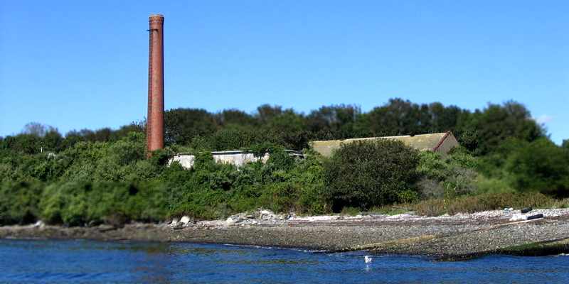
A 2006 photo by George DiGregorio looking east at the smokestack & buildings which remain on the southwest side of Gould Island.
A 2006 photo by George DiGregorio of the remains of a torpedo carriage on Gould Island.
A 2006 photo by George DiGregorio looking southeast at the former torpedo firing pier on the north end of Gould Island.
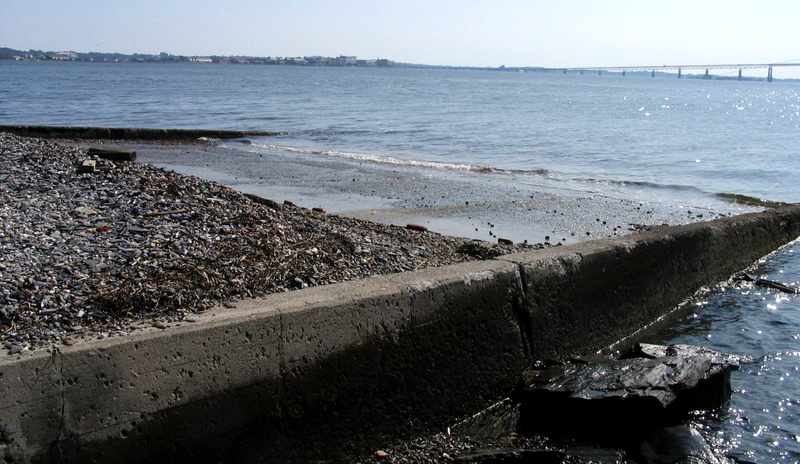
A July 2015 photo by Adam Wolff of the remains of the seaplane ramp on the south side of Gould Island.

A July 2015 photo by Adam Wolff of the interior of the building on the southwest side of Gould Island.
____________________________________________________
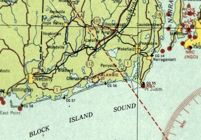
Charlestown Airport / Atlantic Airport, Charlestown RI
41.38, -71.63 (East of Westerly, RI)
Charlestown Airport, as depicted on the Boston Chamber of Commerce's
1931 "Airports & Landing Fields of New England" (courtesy of Chris Kennedy).
The date of construction of this small civilian airport along the Atlantic coast has not been determined.
The earliest reference to the Charlestown Airport which has been located was in an oral history by Helen Church (courtesy of Jean Pellam),
in which Helen recalled, "South of Post Road was a field that served as an airstrip in the early 1920s for bi-wing aircraft.
Every Sunday the Providence Journal Newspaper would deliver the Sunday edition to the airstrip & the newspapers would be flown to the residents of Block Island."
The earliest directory listing which has been located of Charlestown Airport
was in the Boston Chamber of Commerce's 1931 "Airports & Landing Fields of New England" (courtesy of Chris Kennedy).
It described Charlestown as a commercial airport, located 9 miles east of Westerly.
The field was said to consist of a 64-acre rectangular sod & loam field, measuring 3,340' north/south by 700' east/west.
The field was also said to have a 60' x 40' hangar.
No airport in Charlestown was depicted on the 1933-34 Boston Sectional Charts.
The airport was evidently renamed "Atlantic" at some point between 1931-35,
as that is how it was labeled on the June 1935 Boston Sectional Chart.
According to Chris Kennedy, Atlantic Airport was described as being located 3/4 mile east of Charlestown.
The field was said to have 3 runways, with the longest being the 2,640' northeast/southwest strip.
A hangar was located in the northeast corner.
The last aeronautical chart depiction which has been located of Atlantic Airport was on the January 1936 Boston Sectional Chart.
Atlantic Airport was evidently closed (for reasons unknown) at some point in 1936,
as it was no longer depicted on the September 1936 Boston Sectional Chart.
The airport was evidently reopened under the name of Charlestown Airport at some point in 1936-37,
as that is how it was depicted on the October 1937 Boston Sectional Chart.
The last aeronautical chart depiction which has been located of Charlestown Airport was on the November 1939 Boston Sectional Chart.
It depicted Charlestown as an auxiliary airfield.
According to Jean Pellam, “The airstrip stretched in a southwest/northeast direction.
The airstrip closed in 1939 when the owner of the property, Eleanor Baker, initiated plans for a residential development on the property.”
Charlestown Airport was no longer depicted on the May 1941 Boston Sectional Chart.
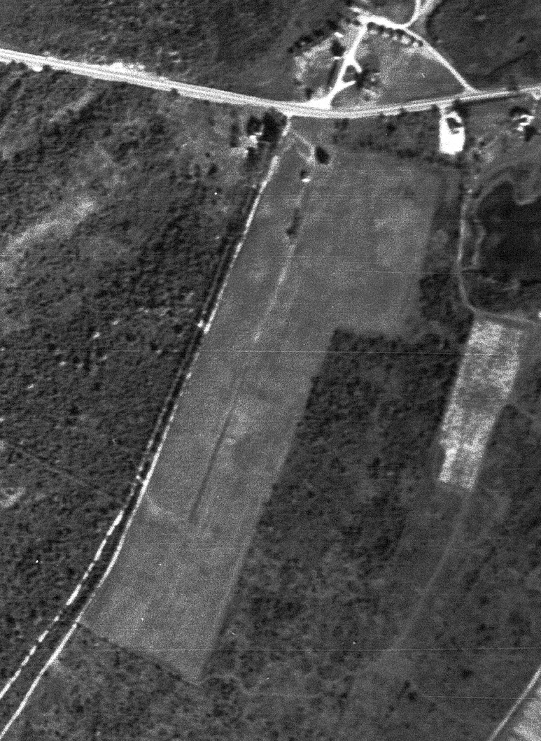
The earliest photo which is available of Charlestown / Atlantic Airport was a 10/9/41 USGS aerial view.
It depicted an unpaved northeast/southwest runway, with a single small building at the north end.
There was no sign of recent aviation activity.
A 1963 aerial view still showed the Charlestown / Atlantic Airport site to remain without redevelopment,
with what appeared to be an unpaved northeast/southwest runway, with a single hangar at the north end.
A 1970 aerial photo still showed the Charlestown Airport site as remaining clear.
A 1995 aerial view showed that North Niantic Drive & houses had been built over the site of the Charlestown Airport runway,
but the hangar remained on the north side.
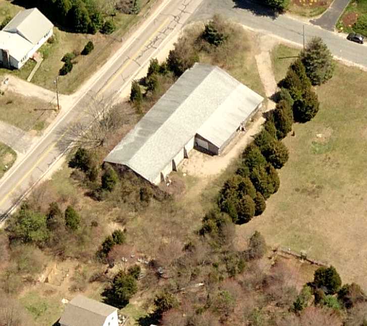
A circa 2010 aerial view looking east at the only remaining trace of Atlantic Airport:
a cement block hangar on the southwest corner of Matunuck Schoolhouse Road & Atlantis Drive.
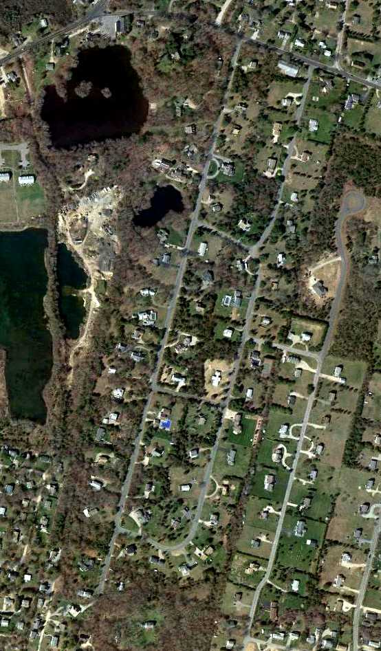
A 4/2/12 aerial photo showed the hangar at the northeast corner was the only remaining trace of Atlantic Airport.
Jean Pellam reported in 2013, “The airstrip stretched in a southwest/northeast direction along or close to one of the roads in the subdivision, Atlantis Road or North Niantic.
I think a case could be made that the airstrip provided the base for one of those roads, probably North Niantic.
The only remaining evidence of the airstrip is the cement block hangar on the southwest corner of Matunuck Schoolhouse Road & Atlantis Drive
that in more recent years has been used to store potatoes & contractor's equipment.
The hangar is overgrown with weeds & hard to see from the road, but it's there.”
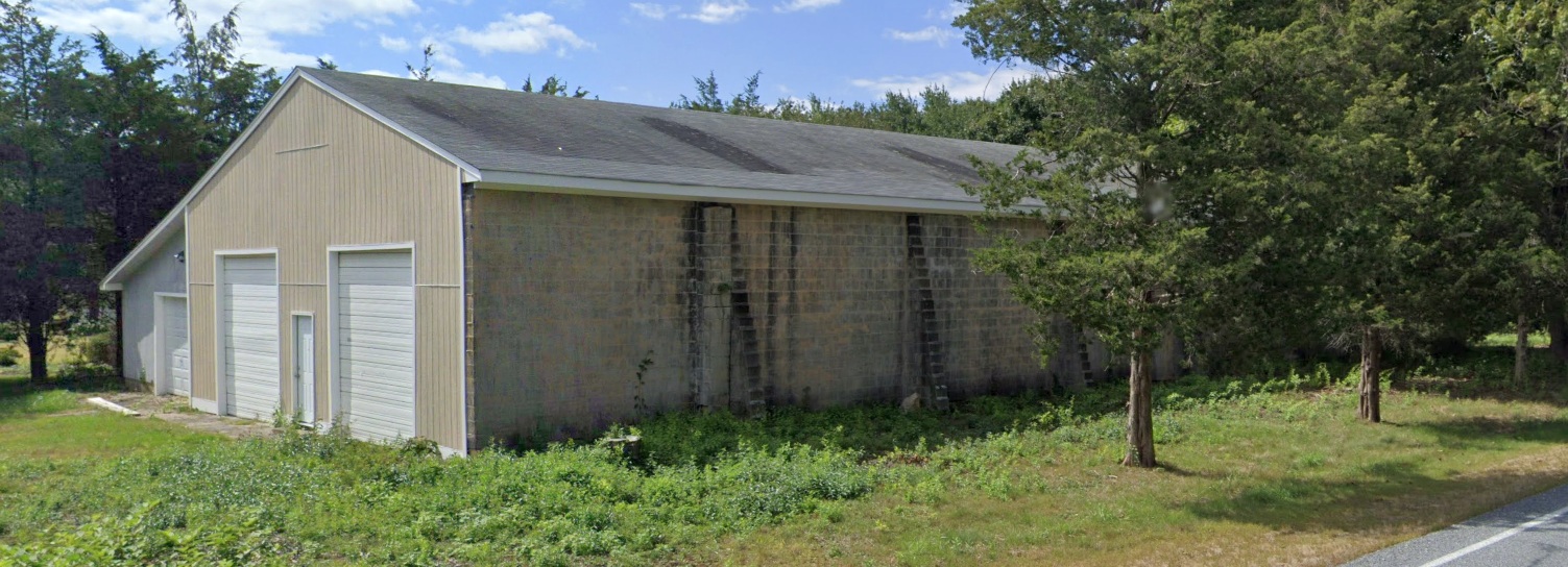
A 2023 photo looking southwest at the former hangar at the northeast corner of the Atlantic Airport site.
____________________________________________________
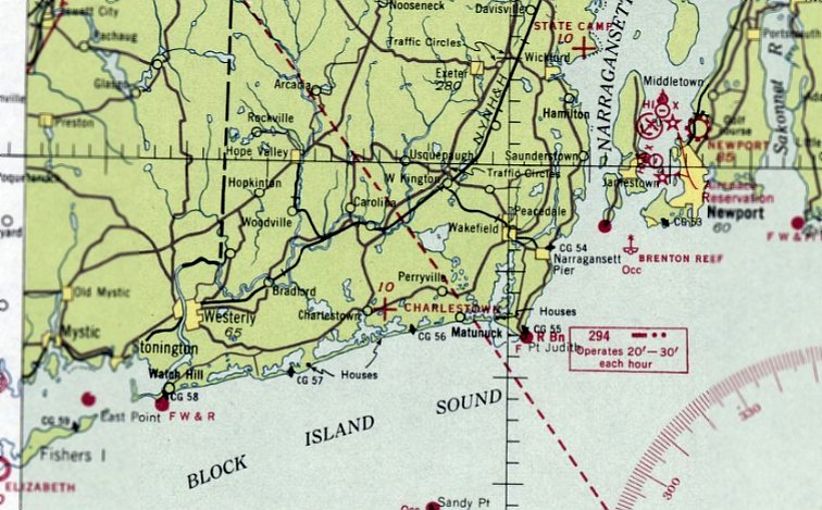
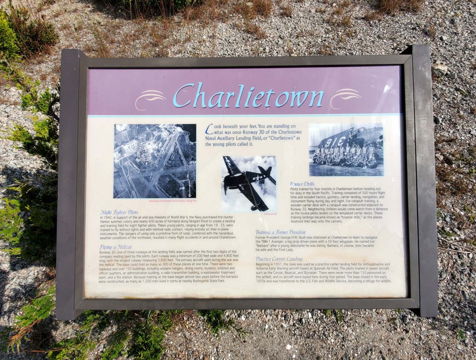
Charlestown Naval Auxiliary Air Station, Charlestown RI
41.367, -71.666 (East of Westerly, RI)
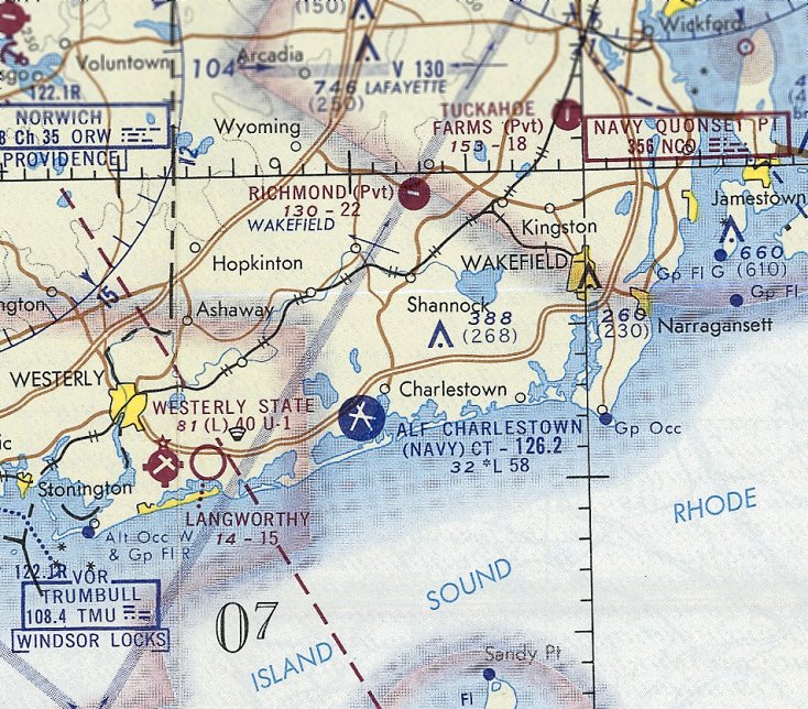
"Charlestown (Navy)", as depicted on the November 1943 Boston Sectional Chart.
In 1942, the Navy constructed Charlestown NAAS, a satellite airfield for Quonset Point NAS.
Charlestown was used to train night fighter squadrons,
and also was the home of the Navy Air Navigation Project,
which developed & tested navigation aids & traffic control systems.
Charlestown NAAS was not yet depicted on the November 1942 Boston Sectional Chart.
The earliest depiction which has been located of Charlestown NAAS was on the November 1943 Boston Sectional Chart.
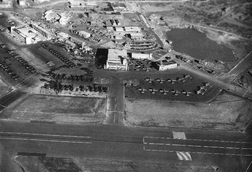
A WW2-era aerial view looking southeast at the ramp & hangars at Charlestown (National Archives photo).
The aircraft parked on the right are twin engine Beechcraft SNBs that were used to train night-fighter pilots in the use of radar.

A Grumman F6F-5N Hellcat night-fighter, of the type used at Charlestown.
Bob Jeska reports that he "was stationed at Charlestown from the fall of 1944 until the fall of 1945.
First attached to a CASU (Carrier Aircraft Service Unit) and later to NACTU (Night Aircraft Training Unit).
NACTU had F6F-3N & F6F-5N [Hellcats] & TBMs [Avengers].
The F6F-3N used AIA radar, and the F6F5N had APS-6 radar.
The AIA radar had a wave guide that ran from the transmitter-receiver in the belly through the wing fold to the antenna.
Keeping the guide in the necessary precision alignment through the fold was a bear, and needed constant attention.
The APS-6 had the transmitter-receiver out on the wing & a co-ax cable brought the signal into the plane.
The TBM didn't always carry radar, but when it did, it was an APS-4.
It was housed in a thing that looked like a finless bomb, fitted on a bomb rack out on the wing.
I was an Electronic Technician's Mate & tuned & repaired the radios, altimeters, radars, and IFF.”
The 1945 AAF Airfield Directory (courtesy of Scott Murdock) described Charlestown Naval Auxiliary Air Facility
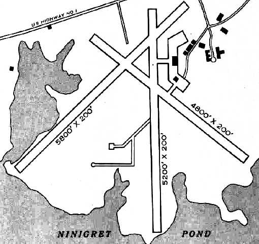
as a 589 acre rectangular property having 3 bituminous runways, the longest being the 5,800' northeast/southwest strip.
The field was said to have a single 160' x 120' wooden hangar, to be owned by the U.S. Government, and operated by the Navy.
A 1945 Navy aerial view of Charlestown (courtesy of Ron Plante).
According to James Nagy, he witnessed an F8F Bearcat crash at NAAS Charlestown in 1947 during night carrier landing practice.
A 1951 aerial view of Charlestown (from the RIGIS at the University of Rhode Island, via Chris Kennedy)
showed the field remaining completely intact, including at least 3 hangars.
There were no aircraft visible on the field, however.
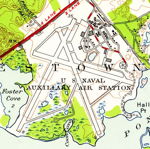
The 1953 USGS topo map depicted Charlestown U.S. Naval Auxiliary Air Station”
as having 3 paved runways, taxiways, several hangars, and a large number of buildings.
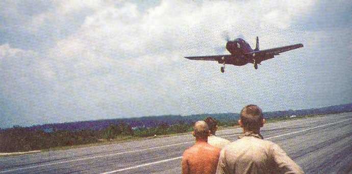
Field Carrier Landing Practice at Charlestown in the mid 1950s
by AD-1 Skyraiders from VAW-12 from nearby NAS Quonset Point.
Photo is from Guppy Pilot, by Roger Smith, courtesy of John Eckberg.
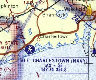
"Charlestown ALF (Navy)" was depicted on the 1955 Boston Sectional Chart (courtesy of Graeme Smith)
as having a 5,800' paved runway & a control tower.
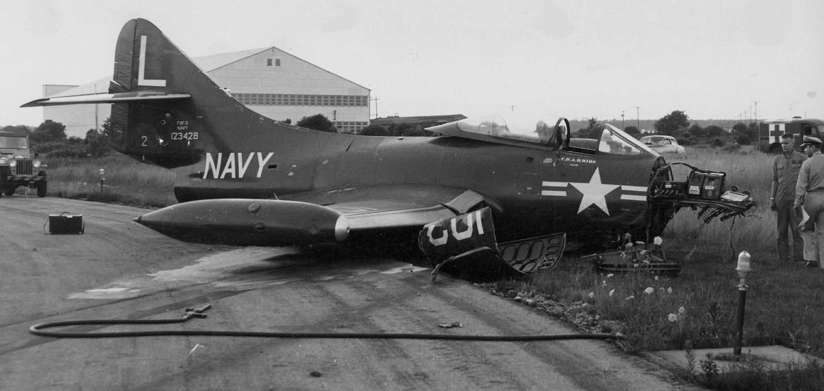
A circa 1950s photo of a VF-71 Grumman F9F-2 Panther (BuNo 123428) which crashed at NAAS Charlestown's Runway 30, with a hangar visible in the background.
The runways of Charlestown were used for drag racing in 1958-59,
as described in the November 1959 issue of Rodding Magazine (courtesy of Marty Lineen).
A 1962 aerial view of Charlestown (from the RIGIS at the University of Rhode Island)
showed that 2 of the 3 hangars had been removed at some point between 1951-62,
with only the central hangar (with attached control tower) still standing.
Mary Ann Guerin reported, “Mount St. Charles Academy in Woonsocket bought one of the [Charlestown] hangars in the early 1960s.
The school had it dismantled & trucked to Woonsocket where it was re-purposed into an ice rink.
My father graduated Mount in 1960 & stated that the rink had not yet been built.
My grandfather was sub-contracted by the engineering firm hired by the school to do the crane work & trucking.”
"ALF Charlestown (Navy)" was depicted on the 1965 Boston Sectional Chart (courtesy of John Voss).
The Aerodromes table on the reverse side of the chart described the field as having 3 asphalt runways, with the longest being 5,800'.
Starting in 1965 some suborbital sounding rockets were launched from Charlestown.
The biggest campaign took place on 5/30/65 in order to watch a solar eclipse.
"ALF Charlestown (Navy)", as depicted on the 1968 Boston Sectional Chart (courtesy of Mike Keefe).
It depicted Charlestown as having 3 paved runways, with the longest being 5,800'.
The last photo which has been located of an aircraft at Charlestown
was a circa 1968 picture by John Gogol of a Navy AD Skyraider which made a gear-up landing.
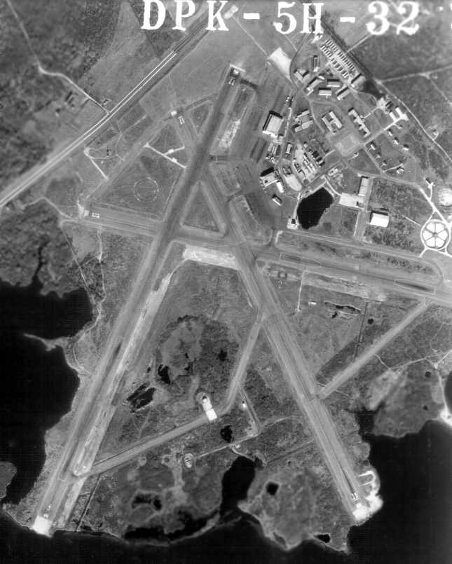
A 3/1070 USGS aerial view of Charlestown showed the runways remained intact, but 2 of the 3 hangars had been removed at some point between 1951-70.
There were no aircraft visible on the field.
The last depiction which has been located showing ALF Charlestown as an active airfield was on the June 1973 NY Sectional Chart (courtesy of Ron Plante).
It depicted Charlestown as having 3 paved runways, with the longest being 5,800'.
According to Hal Marshall (who served at Charlestown from 1968-71), the base was disestablished in 1974.
James Brennan recalled, “I visited the former Charlestown Navy Auxiliary Air Field quite a few times starting in the 1970s
and climbed up into at least one of the control tower cabs.
When were able to get away with it, it was great to explore it; there used to be a couple of wrecked planes on a runway.
Maybe the last time we visited 'illicitly', we were greeted (not quite) by some enforcement type who was not pleased with our visit.”
In the early 1970s, the New England Power Company proposed to build a nuclear power plant at the former Naval Air Station in Charlestown.
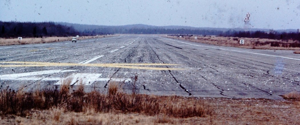
A 1976 photo by Robert Owens (courtesy of David Crandall) looking along Charlestown's abandoned Runway 4/22.
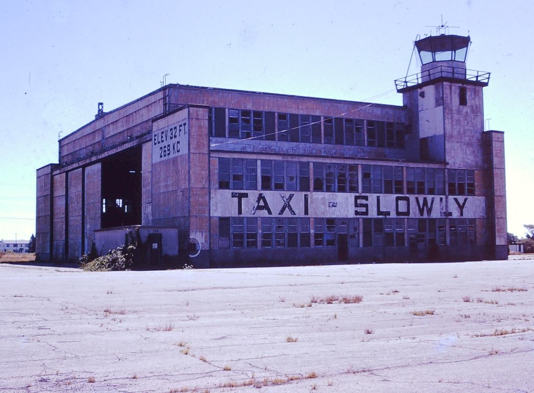
A 1976 photo by Robert Owens (courtesy of David Crandall) of Charlestown's abandoned hangar & attached control tower.
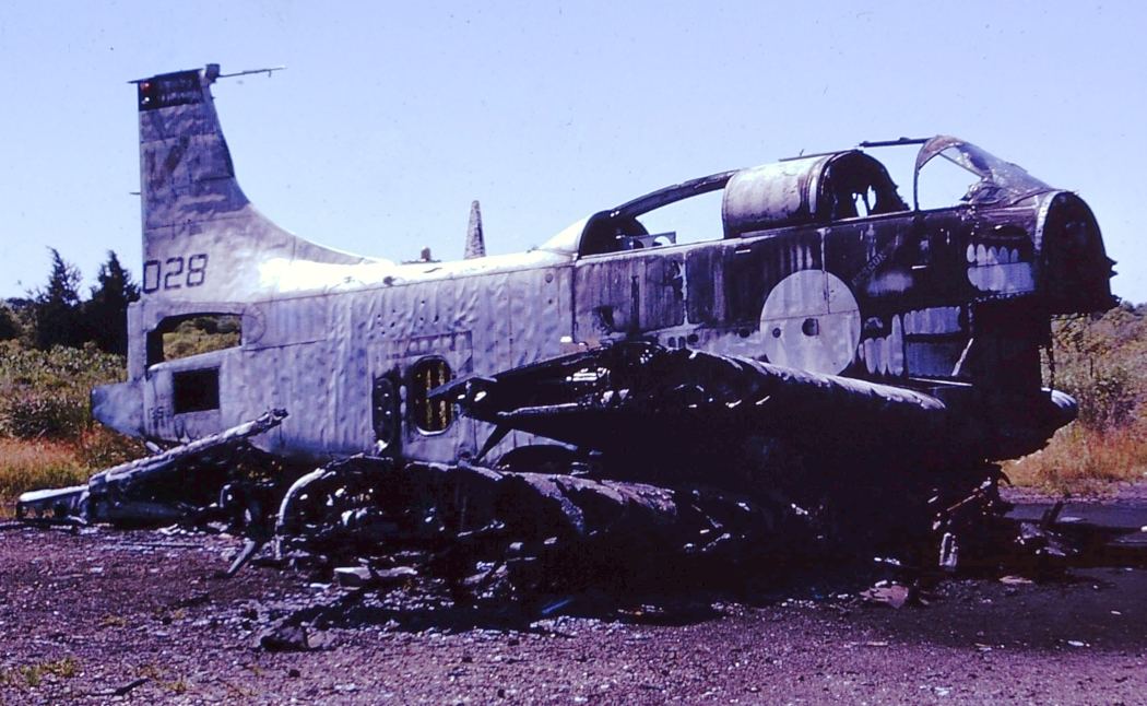
A 1976 photo by Robert Owens (courtesy of David Crandall) of the ruins of an AD-5 Skyraider at Charlestown.
A 1976 photo by Robert Owens (courtesy of David Crandall) of a wreck of an S-2 Tracker at Charlestown, with the hangar in the background.
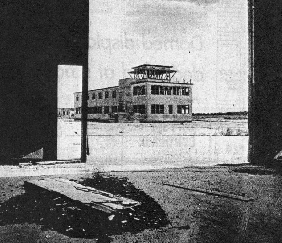
A 1977 photo (courtesy of Paul Zecchino) looking outward from a Charlestown hangar toward the control tower.
The original caption said “The former Charlestown Naval Auxiliary Landing Field may soon be rezoned to exlude the nuclear power plant now proposed for the site.”
After a protracted legal dispute from local opposition groups, New England Power abandoned its plans for a nuclear plant at Charlestown
and the Naval Air Station land was deeded to the town of Charlestown for use as a park & wildlife refuge.
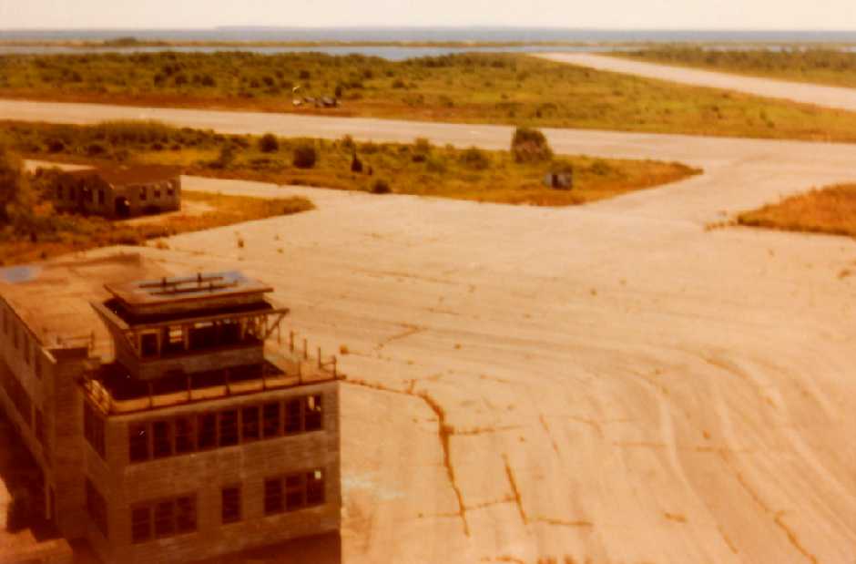
A 1978 picture by John Gogol looking southwest at the NAS Charleston control tower from the roof of the adjacent hangar.
John recalled, “We would go there every summer, I can still remember them practicing day & night.
We couldn't talk at breakfast because it was so loud, I would run out & watch them take off over our grass field in the morning,
the field on the west side of the airport across from the pond was a civilian cottage strip.
And we would go crabbing around the NAS.
At night I would stay up as late as possible watching the string of red blinking lights do touch & goes.
I think I got in to the field by riding my bike & getting through a hole in the fence;
there was a Skyraider I used to climb around & I climbed up into the control tower.”
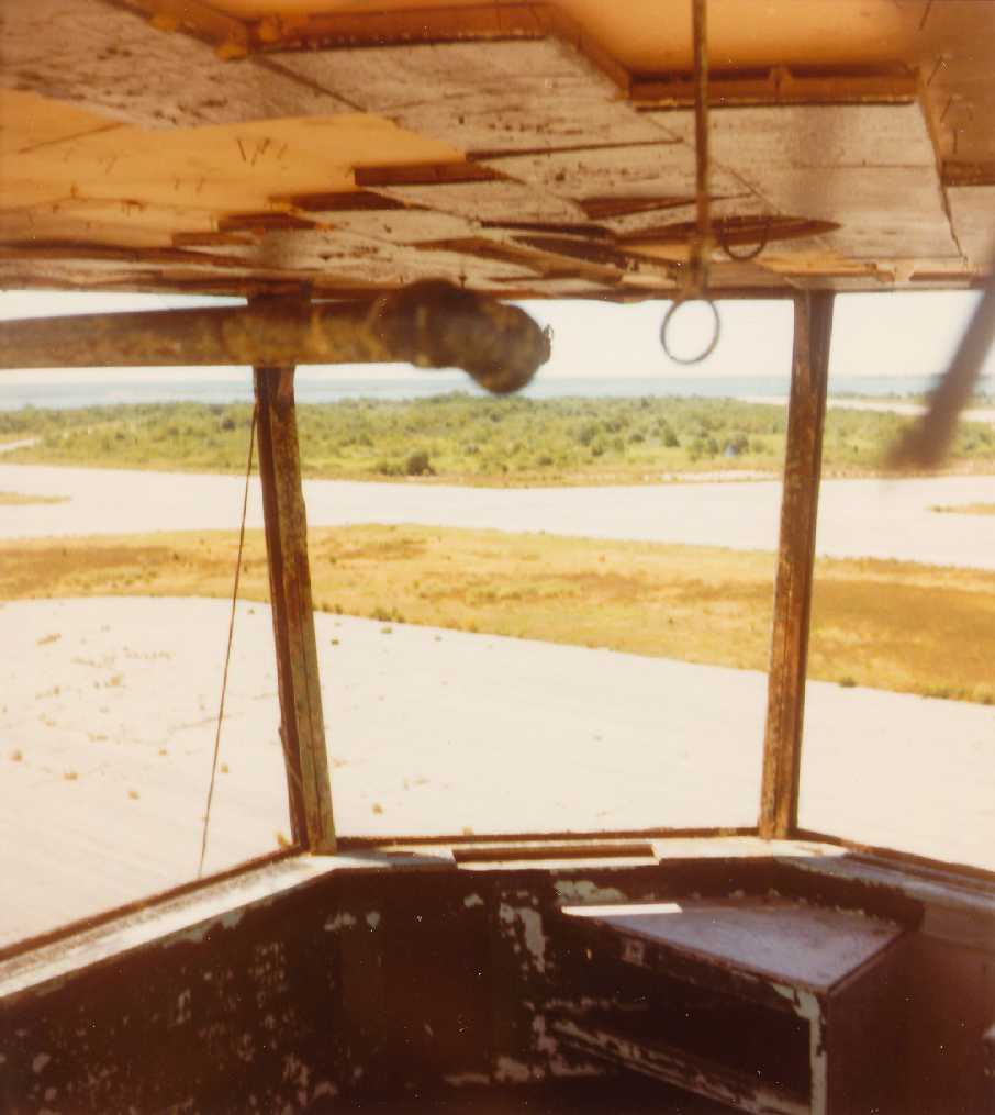
A 1978 picture by John Gogol looking southwest from inside the NAS Charleston control tower cab.
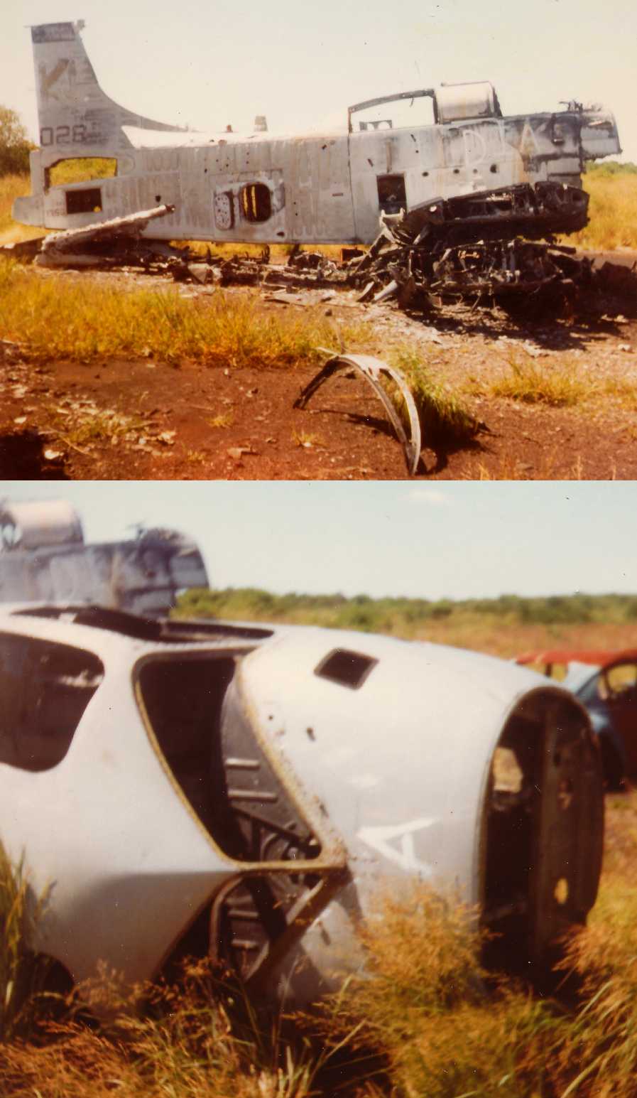
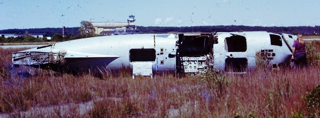
Two 1978 pictures by John Gogol of an AD-5 Skyraider & the remains of another aircraft (an S-2?) at the former NAS Charleston.
"ALF Charlestown" was labeled Closed on the December 1979 NY Sectional Chart (courtesy of Ron Plante).
Bob Jeska reports from a visit to the site in 1980, "The hulks of 2 large hangars was all that remained at that time,
but the gate was chained so that we couldn't get close."
A 1981 aerial view of Charlestown (from the RIGIS at the University of Rhode Island)
showed that the last hangar still remained standing at that point.
However, this hangar was subsequently removed at some point between 1981-88,
as a 1988 aerial view of Charlestown (from the RIGIS at the University of Rhode Island)
showed that all of the hangars had been demolished by that point.
The 1989 USGS topo map depicted the “U.S. Naval Reservation Auxiliary Landing Field”
as having 3 paved runways, numerous taxiways, ramps, and 2 large hangars.
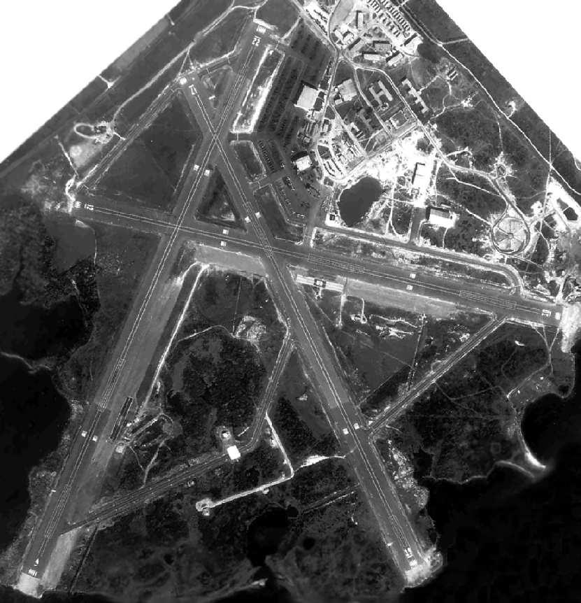
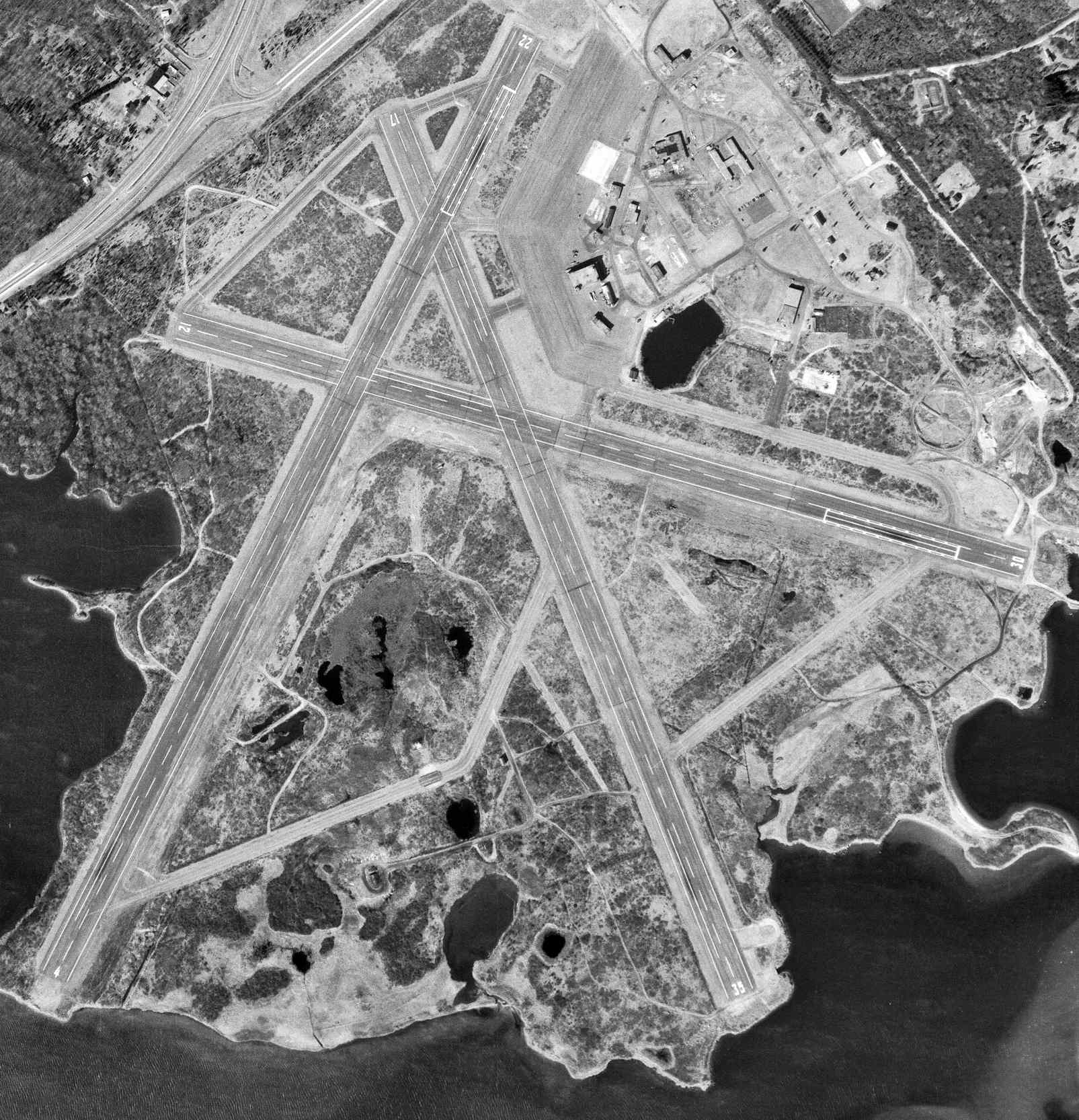
A 1995 USGS aerial view showed the Charlestown runways remained intact.
Charlestown still had some significant aviation usage as late as 1999:
on 11/18/99 the Comet Chaser aeronomy mission was launched on a Viper-Dart rocket from Charlestown, reaching an apogee of 55 miles.
According to James Brennan, “A friend in my flying club got to land there with several warbirds (excuse was 'press plane') before the runways were spoiled -
it was part of a Memorial Day deal relating to the stone monument.”
The Charlestown property is currently the Ninigret Park & Wildlife Refuge.
A 2002 photo by John Eckberg of a remaining portion of the runway & taxiway at the north end of Charlestown.
The shelter used for events was built in the shape of a control tower.
James Brennan reported in 2005, “Charlestown is now a town park
and the big cheese behind it caused most of the fine runways to be chewed up.”
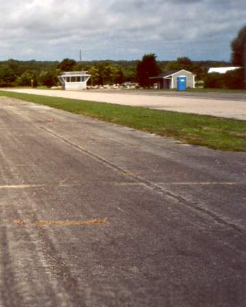
A circa 2006 aerial view looking west at the remains of Charlestown's Runway 30,
showing the parking lot which was built over the runway end,
but the inexplicable sight of what appears to be relatively recently-painted runway numbers – why?
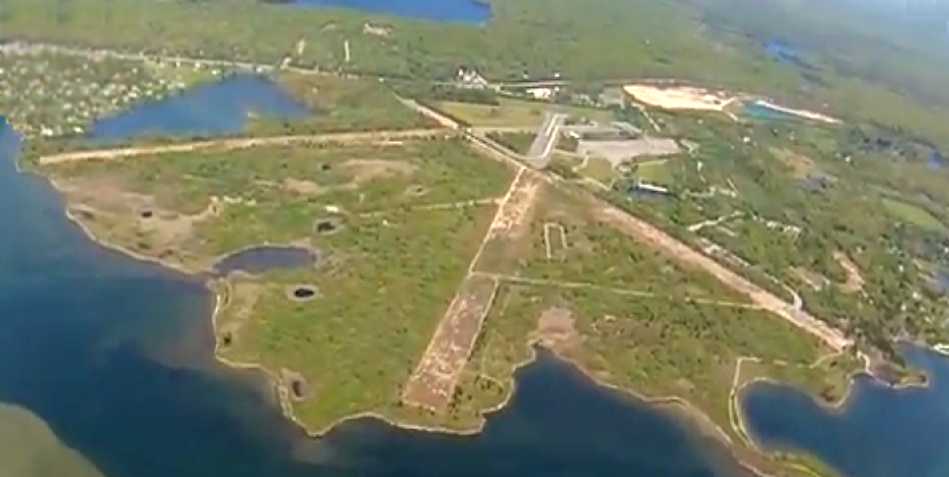
A still from a 2012 video by Graeme Smith looking north at the remains of the Charlestown runways.
Graeme observed, “Charlestown Naval Air Station [is] now being allowed to over grow as the Ninigret Nature Reserve.
Its proximity to Westerly & its similar layout have trapped more than one student solo into trying it before breaking off as they realize there are bushes on the runways!”

A 2014 photo by John Zirolli looking along the remains of a Charlestown runway.
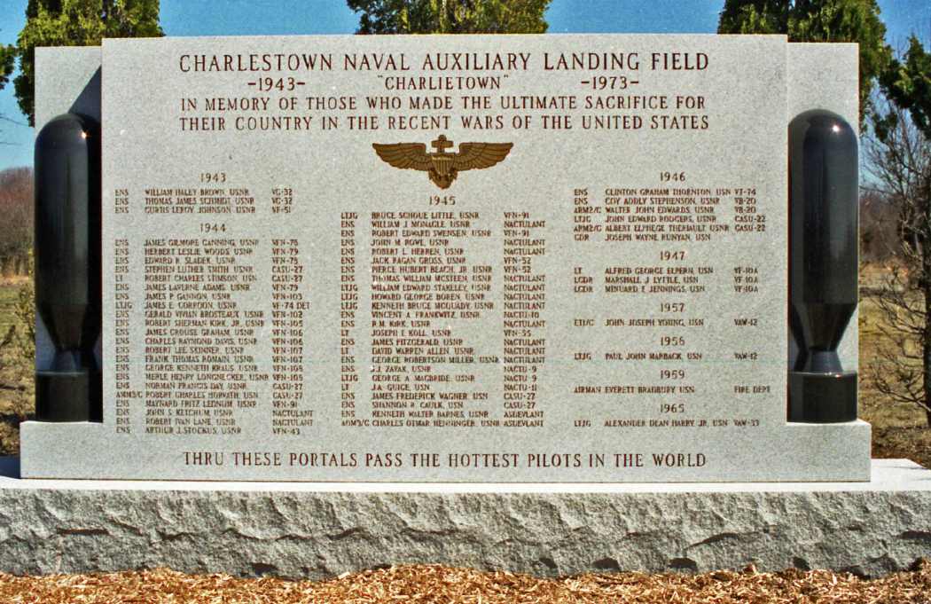
A 2014 photo by John Zirolli of a Charlestown NALF memorial plaque.
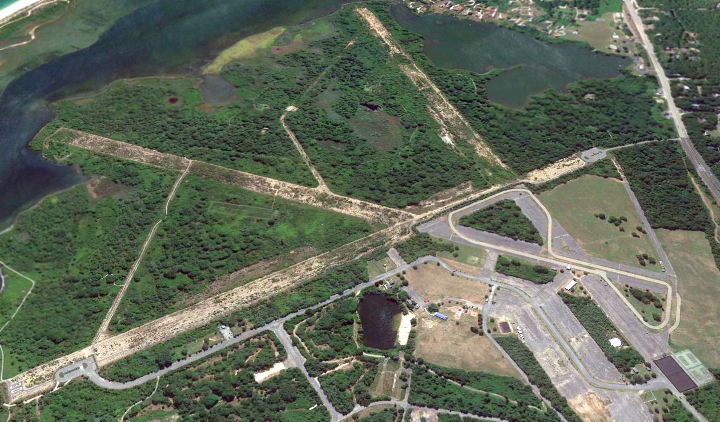
A 2016 aerial view looking southwest showed the Charlestown runways were still recognizable, although their pavement has been progressively removed.
A 10/13/19 photo by Mike Ninivaggi of the historical sign at the site of Charlestown NALF.
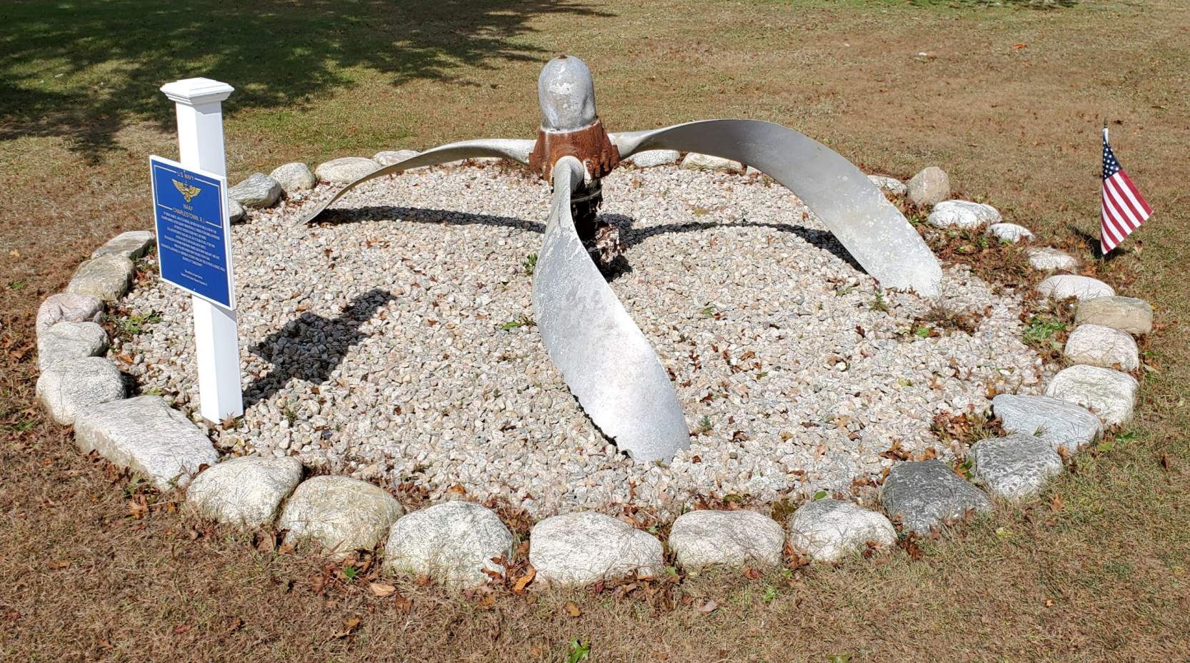
A 10/13/19 photo by Mike Ninivaggi of memorial fashioned from an aircraft propeller at the site of Charlestown NALF.
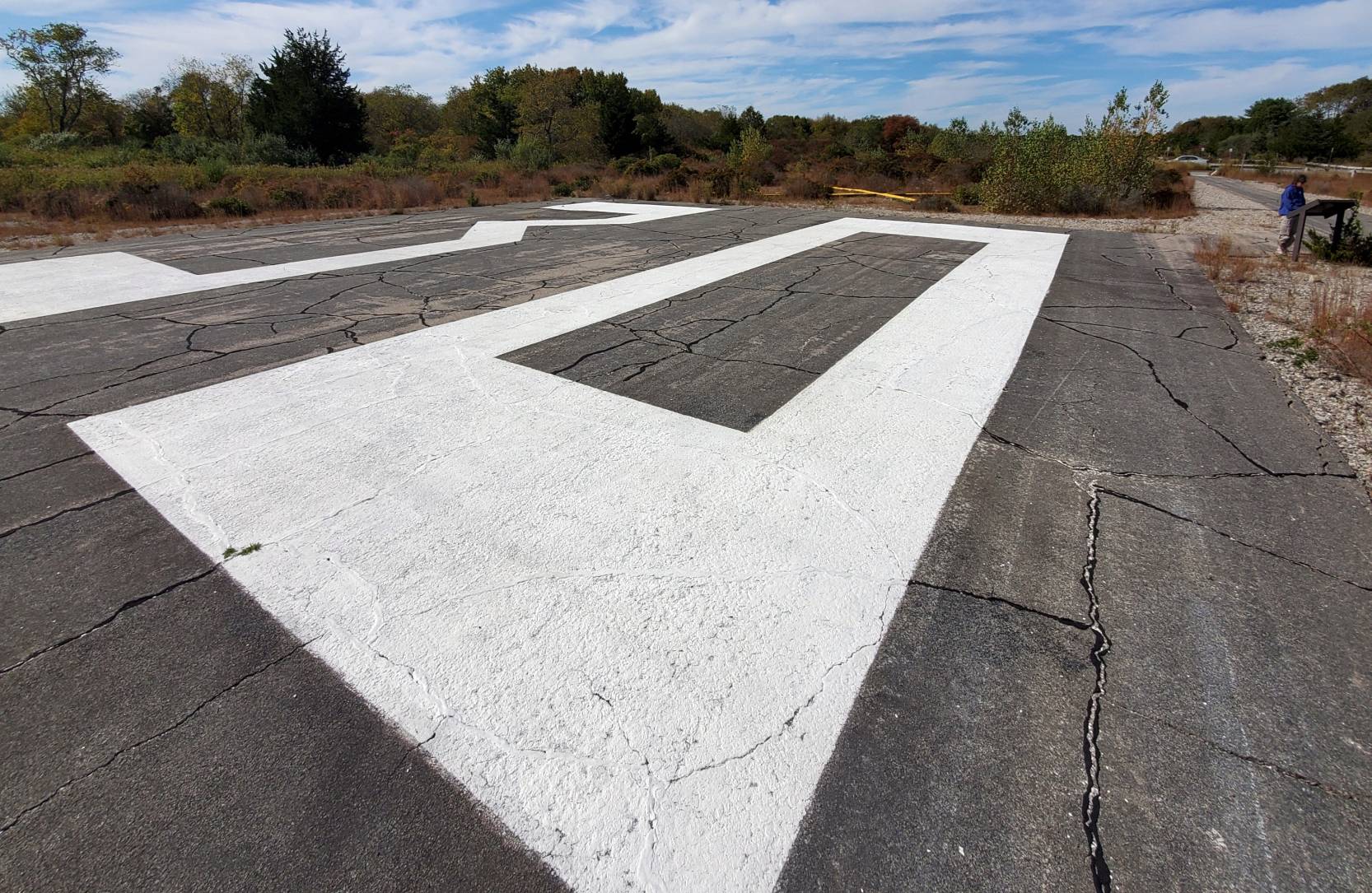
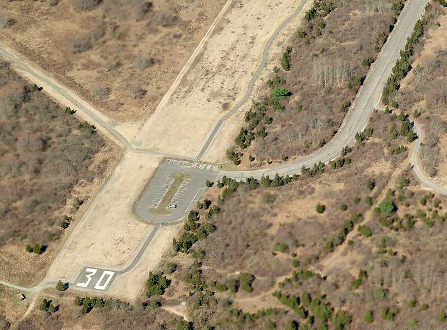
A 10/13/19 photo by Mike Ninivaggi of the former Charlestown NALF Runway 30 markings.
Mike observed, “The reason they left the Runway 30 markings is that this is part of their 'Pathway through time' trail that talks about the lands use as farmland, housing, then the airfield.”
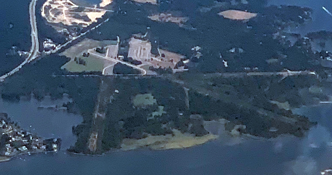
An 8/10/20 aerial view by Rocky Breslow looking northeast at the remains of Charlestown NALF.
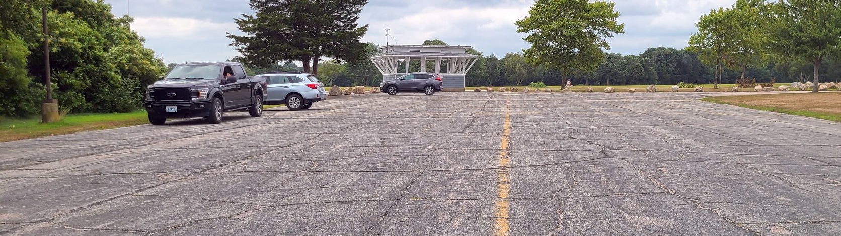
An 8/15/20 photo by Graeme Smith of a shelter built in the shape of a control tower at the site of Charlestown NALF.
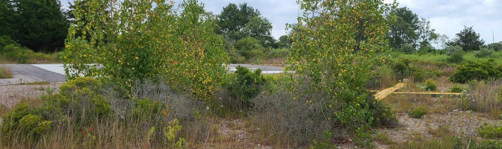
Graeme reported, “Outstanding taxiway markings at the north end of the airport at the intersection of Runways 17 & 22.
The north end of these runways have been retained & a cycle track installed. The shelter that looks like a control tower cab is a facsimile and not original.”
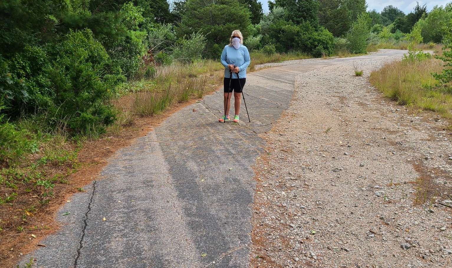
An 8/15/20 photo by Graeme Smith of the remains of Charlestown NALF runway pavement.
Graeme reported, “On the left - the left edge of Runway 12. In the distance the right edge of the runway. This part of the path weaving across the full width of the runway.”
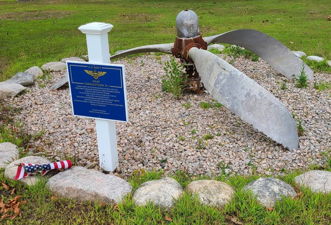
An 8/15/20 photo by Graeme Smith of a A 10/13/19 photo by Mike Ninivaggi of a memorial at Charlestown NALF fashioned from an aircraft propeller recovered from the bay in 1990.
An 8/15/20 photo by Graeme Smith of the remains of a Charlestown NALF runway.
Graeme reported, “Though the yellow X is rather buried in the brush. From the air it looks like you might be able to make an emergency landing here.
Ten years ago when I first flew around here, that might have been the case. But after walking the trails today - the brush & trees are beginning to get to be quite substantial. I'd avoid this & go for the beach.”
The site of Charlestown NAAS is located south of the intersection of Post Road & RI Route 1A South.
See also:
http://cshell.com/ccc/cinfo/hist.htm
http://www.riedc.com/mcds/Charlestown.html#introduction
____________________________________________________
Since this site was first put on the web in 1999, its popularity has grown tremendously.
If the total quantity of material on this site is to continue to grow,
it will require ever-increasing funding to pay its expenses.
Therefore, I request financial contributions from site visitors,
to help defray the increasing costs of the site
and ensure that it continues to be available & to grow.
What would you pay for a good aviation magazine, or a good aviation book?
Please consider a donation of an equivalent amount, at the least.
This site is not supported by commercial advertising –
it is purely supported by donations.
If you enjoy the site, and would like to make a financial contribution,
you
may use a credit card via
![]() :
:
Please consider checking the box to make a monthly donatation.
For a mailing address to send a check, please contact me at: paulandterryfreeman@gmail.com
If you enjoy this web site, please support it with a financial contribution.
please contact me at: paulandterryfreeman@gmail.com
If you enjoy this web site, please support it with a financial contribution.
____________________________________________________
This site covers airfields in all 50 states.