Abandoned & Little-Known Airfields:
North-Central Pennsylvania
© 2002, © 2022 by Paul Freeman. Revised 11/4/22.
This site covers airfields in all 50 states: Click here for the site's main menu.
____________________________________________________
Please consider a financial contribution to support the continued growth & operation of this site.
Ames Airport (revised 2/16/22) - Bellefonte Airport (revised 6/9/20) - Black Forest Inn Airfield (added 11/3/22) - Blue Swan Airport (revised 7/6/20) - Cherry Springs Intermediate Field / Cherry Springs Airport (revised 1/8/18)
Gordon Airport (added 12/29/19) - Hughesville Airport (revised 7/6/20) - Hyner Field (revised 6/11/21) - Ridge Soaring Gliderport (added 3/22/22)
State College Air Depot (1st location) (revised 6/20/19) - State College Air Depot (2nd location) (revised 5/6/17) - Stultz Field / Peterson Memorial (1st location) (revised 11/4/22)
Tyrone Airport / Peterson Memorial Airport (2nd location) (revised 5/4/20) - Valley Airport / Chemung Valley Airport (revised 5/4/20)
____________________________________________________
Black Forest Inn Airfield, Lock Haven, PA
41.497, -77.583 (Northwest of Philadelphia, PA)
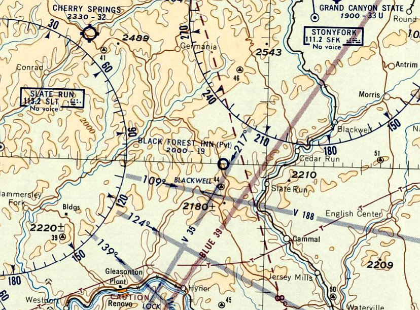
Black Forest Inn Airfield, as depicted on the June 1960 NY Sectional Chart.
This small general aviation airport was evidently established at some point between 1959-60,
as it was not yet depicted on the 1959 NY Sectional Chart.
The earliest depiction which has been located of Black Forest Inn Airfield was on the June 1960 NY Sectional Chart,
which depicted Black Forest Inn Airfield as having a 1,900' unpaved runway.
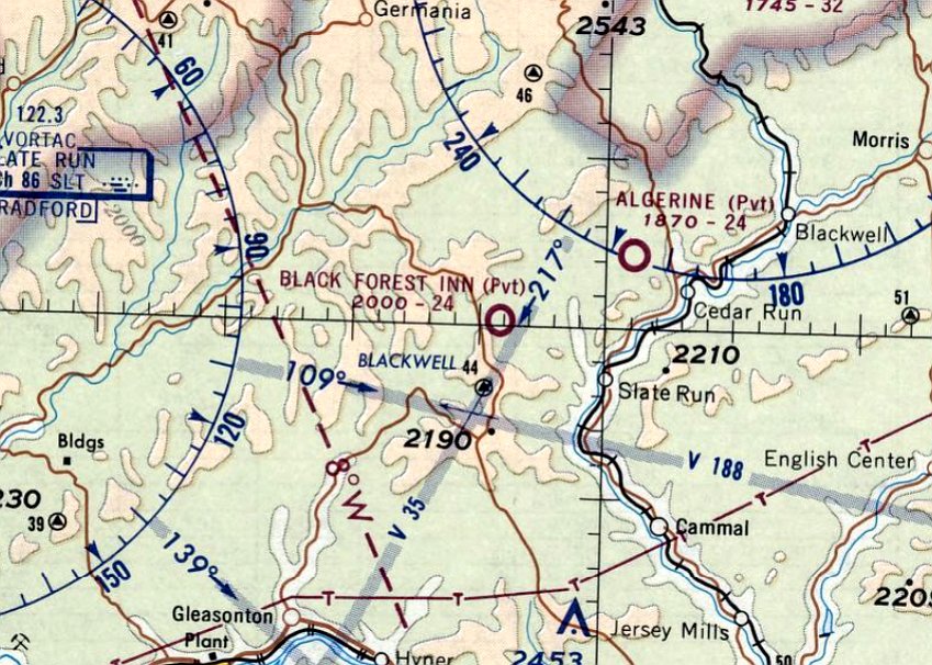
The April 1970 NY Sectional Chart depicted Black Forest Inn Airfield as having a 2,400' unpaved runway.
The earliest photo which has been located of Black Forest Inn Airfield was a 1971 aerial view.
It depicted a single grass northwest/southeast runway.
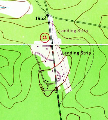
The earliest topo map depiction which has been located of Black Forest Inn Airfield was the 1970 USGS topo map.
It depicted a single unpaved northwest/southeast runway, labeled simply as “Landing Strip”, with a few small buildings on the southwest side.
The last aeronautical chart depiction which has been located of Black Forest Inn Airfield was on the November 1974 NY Detroit Chart (courtesy of Ron Plante),
which depicted Black Forest Inn Airfield as having a 2,400' unpaved runway.
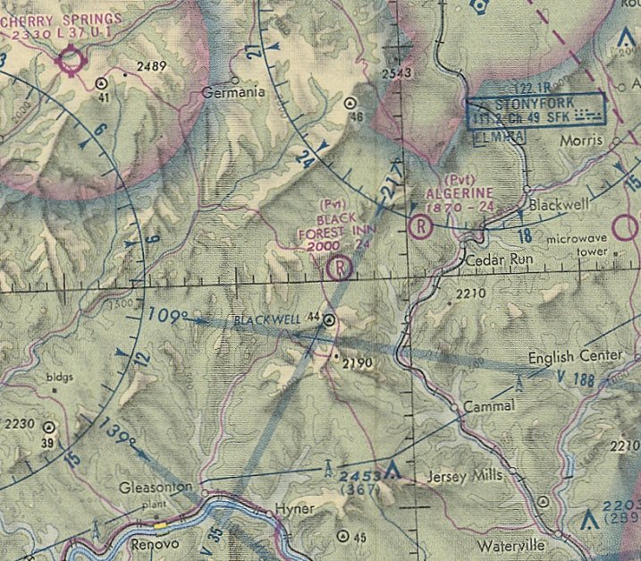
Black Forest Inn Airfield was evidently closed (for reasons unknown) at some point between 1974-81,
as it was no longer depicted on the May 1981 NY Detroit Chart (courtesy of Ron Plante).
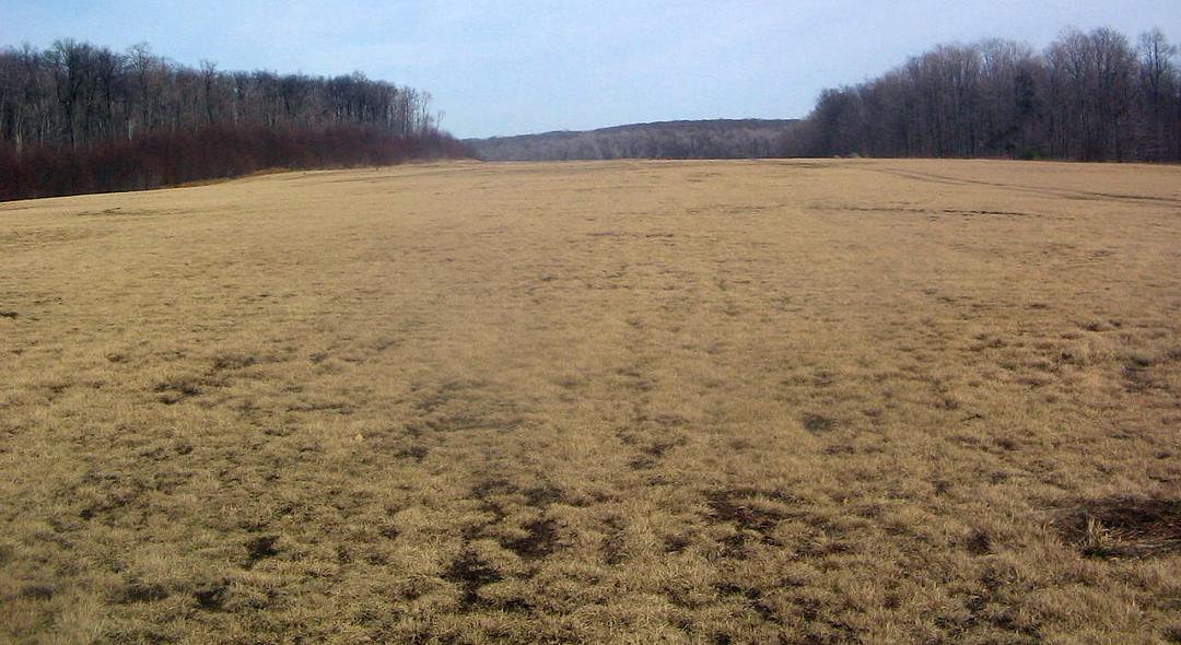
A 2016 aerial view looking northeast showed the Black Forest Inn Airfield remained clear, but with no evident sign of any recent aviation use.
An October 2021 aerial view looking northeast showed the Black Forest Inn Airfield remained clear, but with no evident sign of any recent aviation use.
____________________________________________________
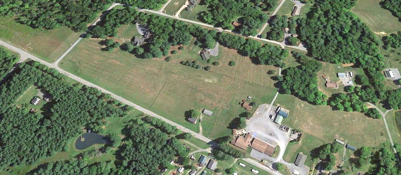
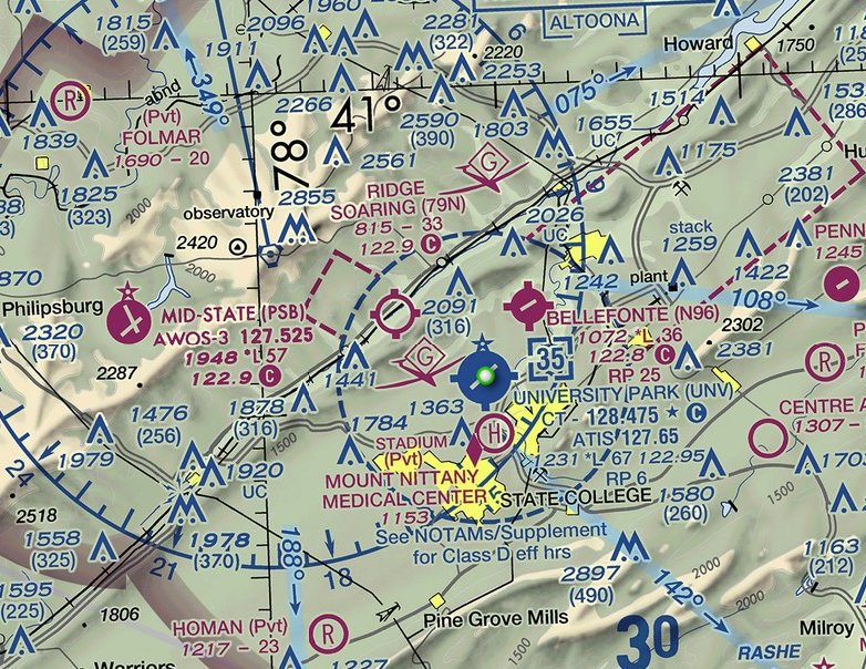
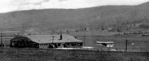
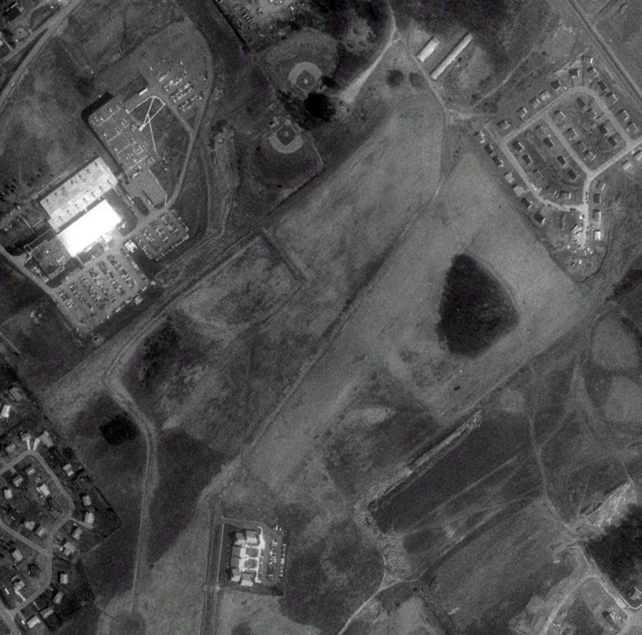
Ridge Soaring Gliderport (79N), Unionville, PA
40.884, -77.907 (Northwest of Philadelphia, PA)
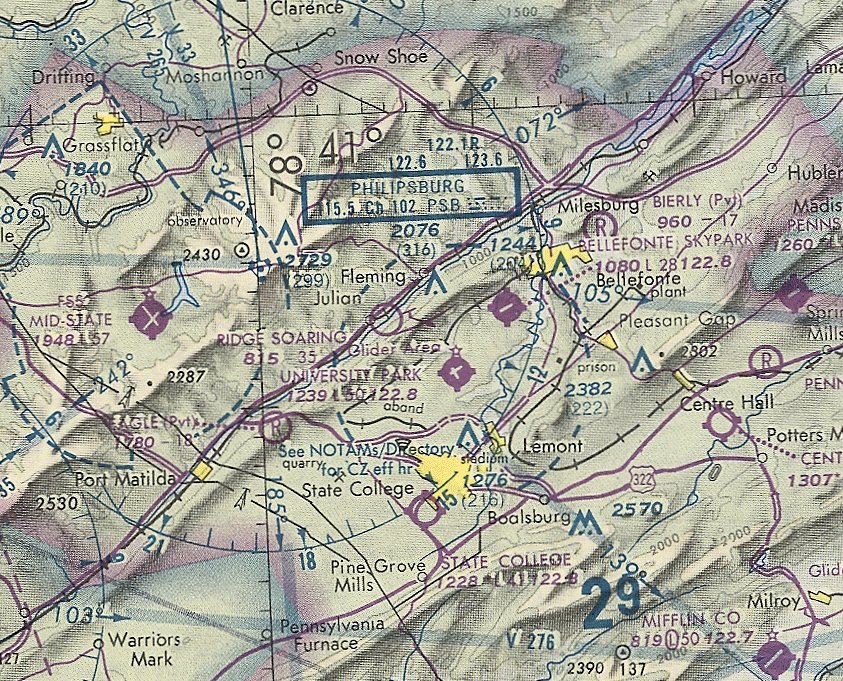
Ridge Soaring Gliderport, as depicted on the May 1981 Detroit Sectional Chart (courtesy of Ron Plante).
Ridge Soaring Gliderport it was not yet depicted on the 1971 USGS topo map or the November 1974 Detroit Sectional Chart (courtesy of Ron Plante).
David Rombach reported, “Ridge Soaring Gliderport opened in 1975. Tom started the business in 1975. The field was used by the local soaring club as an emergency landing field.
When he bought the land he built a bunkhouse, office & hangar. Many long flights were flown from there.”
The earliest depiction which has been located of Ridge Soaring Gliderport was on the May 1981 Detroit Sectional Chart (courtesy of Ron Plante).
It depicted Ridge Soaring Gliderport as having a 3,500' unpaved runway.
The earliest photo which has been located of Ridge Soaring Gliderport was a 1983 aerial view.
It depicted Ridge Soaring Gliderport as having a grass northeast/southwest runway,
with a row of hangars & a dozen aircraft (including several gliders) along the northwest side.
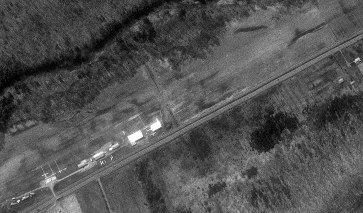
The earliest photo which is available of Ridge Soaring Gliderport was a 1994 aerial view looking south.
It depicted Ridge Soaring Gliderport as having a grass northeast/southwest runway,
with a row of hangars & a 6 aircraft (including several gliders) along the northwest side.
Ridge Soaring Gliderport was not depicted on the 1998 USGS topo map.
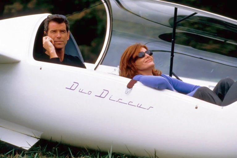
A photo of Pierce Brosnan & Rene Russo in a glider during the 1999 filming of The Thomas Crown Affair at Ridge Soaring Gliderport.
According to Wikipedia, Ridge Soaring Gliderport was world-famous for ridge, thermal & wave soaring, located at the base of the Bald Eagle mountain ridge.
Visitors could see an entire wall of U.S. National & World records that had been set at the airfield.
The airport had a bunkhouse with showers, small kitchen, pilots lounge, motorhome facilities, hangars,
protected storage for glider trailers, a repair shop, and an A&P mechanic & inspector.
Co-owner Thomas Knauff set 5 FAI world records, and over 50 NAA national records flying from Ridge Soaring Gliderport.
Co-owner Doris Grove set 3 FAI female world records flying from Ridge Soaring Gliderport, including being the first woman to fly a glider more than 1,000 km.
David Rombach reported, “Doris Grove also was the flying stunt double for Renee Russo in the Thomas Crown Affair glider scene.”
For the year ending 6/30/06, the FAA Airport/Facility Directory said that Ridge Soaring Gliderport conducted an average of 49 takeoffs or landings per day.
The airport was said to have 34 based aircraft: 4 single-engine & 30 gliders.
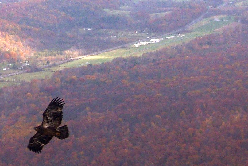
A 2006 aerial view looking north at a juvenile bald eagle overflying Ridge Soaring Gliderport.
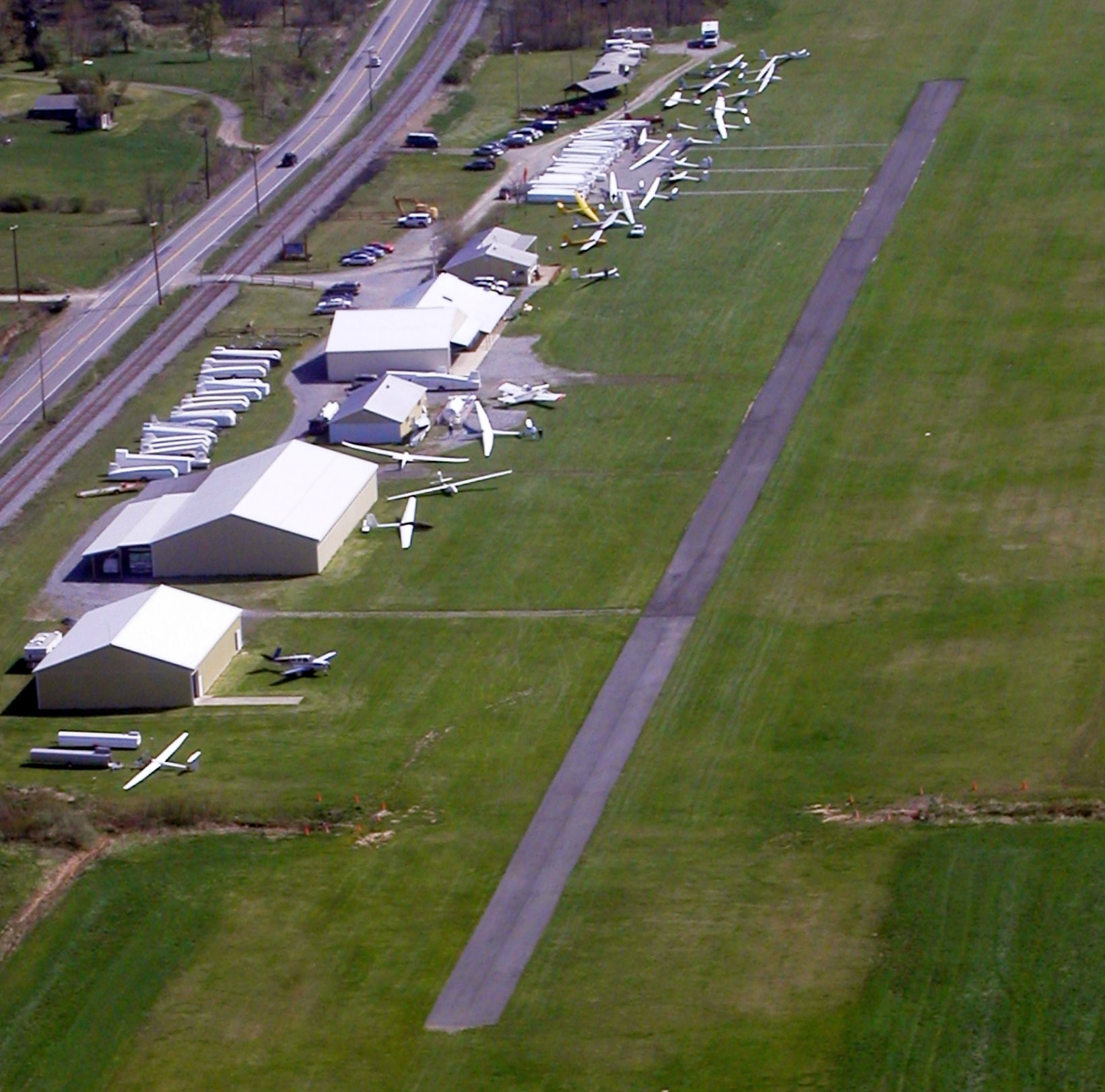
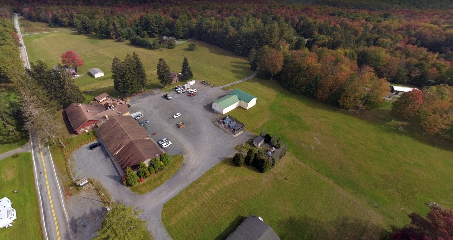
A 2006 aerial view looking northeast at 27 aircraft (predominantly gliders) at Ridge Soaring Gliderport, perhaps the field's zenith of popularity.
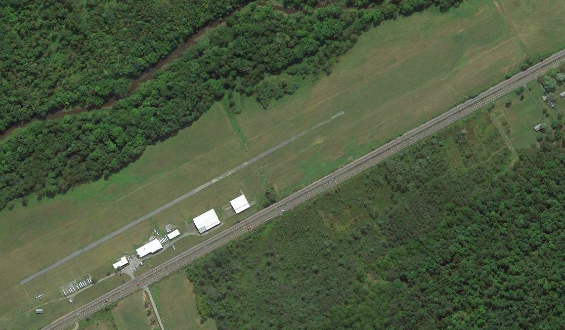
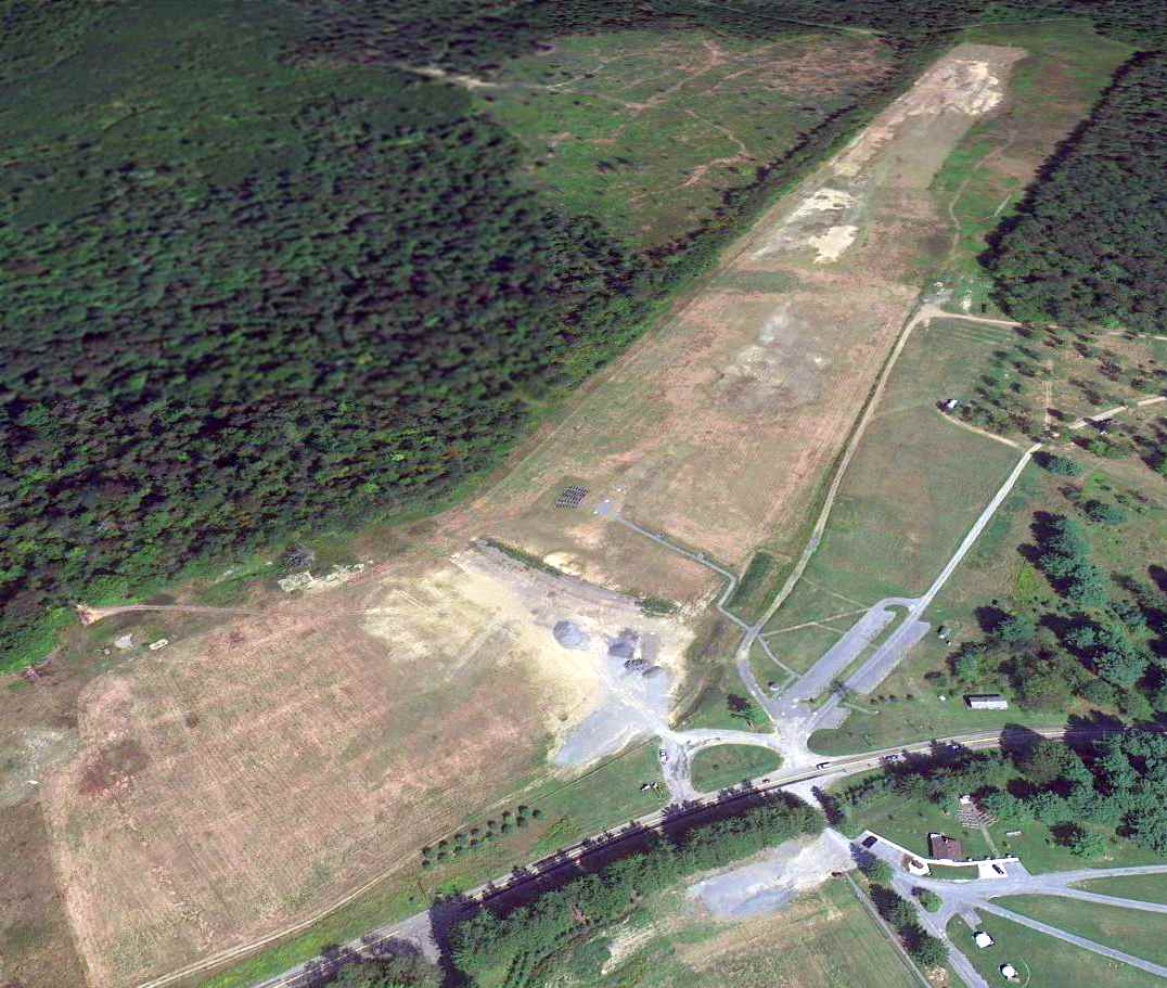
The last aerial view which has been located showing aircraft at Ridge Soaring Gliderport was a 2012 aerial view looking south, which depicted only 2 aircraft on the field.
A 2015 aerial view no longer depicted any aircraft at Ridge Soaring Gliderport.
For the year ending 4/27/21, the FAA Airport/Facility Directory said that Ridge Soaring Gliderport conducted an average of 34 takeoffs or landings per day.
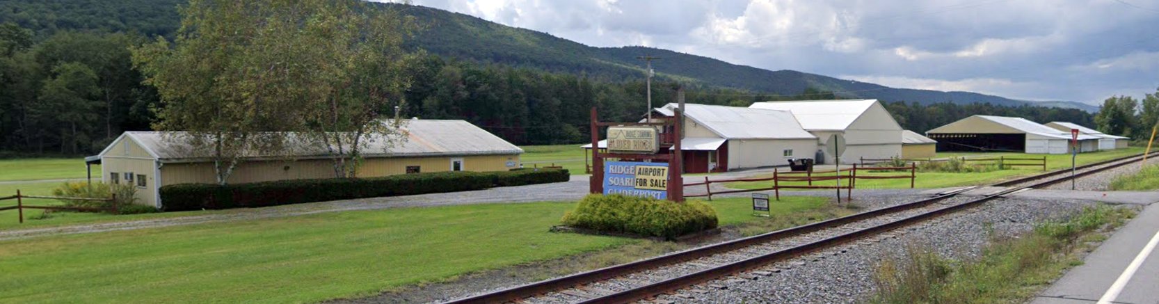
A September 2021 photo looking southwest unfortunately showed “Airport For Sale” posted over Ridge Soaring Gliderport's sign.
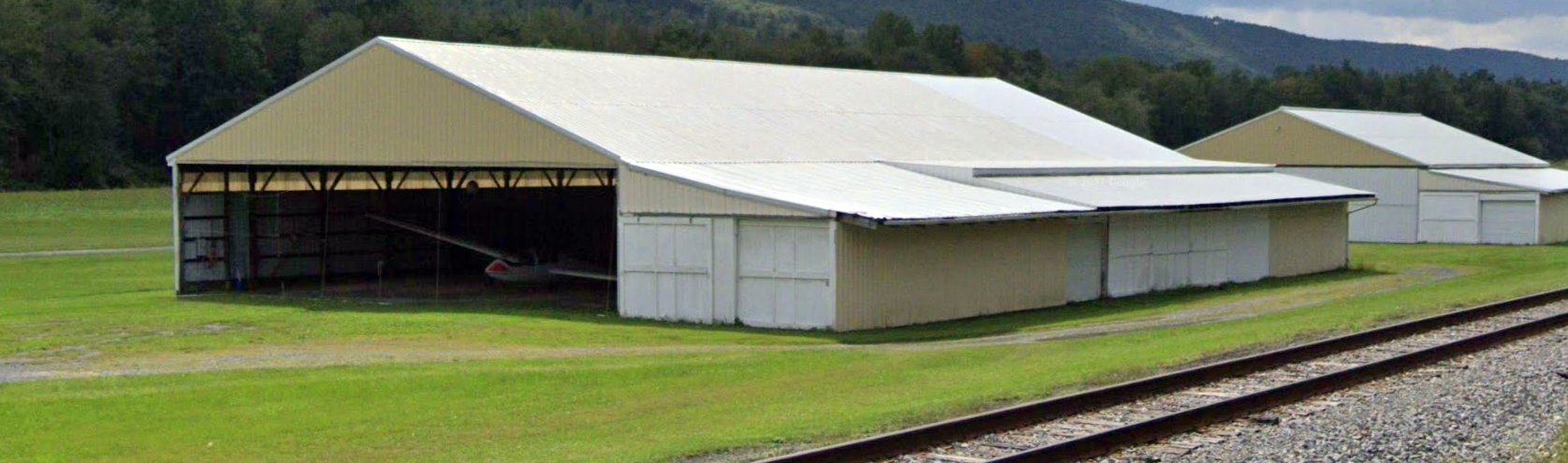
A September 2021 photo looking southwest showed a glider inside a Ridge Soaring Gliderport hangar.
As of 2/24/22, the FAA Airport/Facility Directory described Ridge Soaring Gliderport as having a single 3,322' asphalt/turf Runway 7/25.
The owner was listed as Knauff & Grove Inc., and the manager as Thomas Knauff & Doris Grove.
The field was said to have 10 based aircraft (3 single-engine & 7 gliders).
The 2022 Detroit Sectional Chart depicted Ridge Soaring Gliderport as having a 3,300' unpaved runway, and to conduct glider operations.
The Ridge Soaring Gliderport property was evidently sold in 2022 to be used for non-aviation purposes.
Thanks to David Rombach for pointing out this airfield.
____________________________________________________
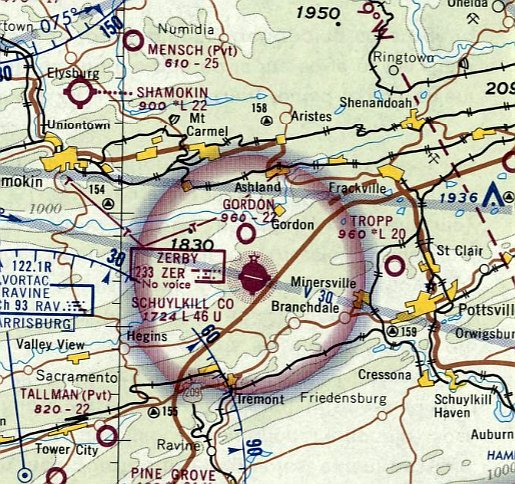
40.74, -76.376 (Northwest of Philadelphia, PA)
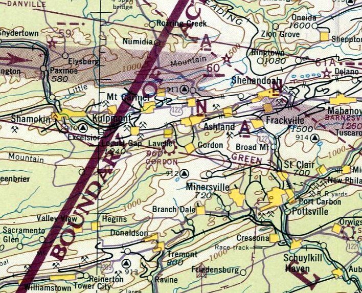
Gordon Airport, as depicted on the May 1943 NY Sectional Chart.
This small general aviation airport was evidently established at some point between 1942-43,
as it was not yet depicted on the November 1942 NY Sectional Chart.
The earliest depiction which has been located of Gordon Airport was on the May 1943 NY Sectional Chart.
It depicted Gordon Airport as a commercial/municipal airport.
Ed Fritz reported, “My dad lived in the the coal fields/mines in Giradville,PA... about 11 miles away [from Gordon Airport].
He earned his flight wings & soloed at Gorden.
I'm pretty sure it was a Civil Air Patrol [airfield].
He told me about him & his brother riding their bikes to get there.
My grandmother told me about his first flight, about how he dipped into the valley at the end of the runway & they were all concerned until he flew up & over the horizon.
I can't imagine what life was like for my Dad, as a 14 year old kid in the coal fields of PA in 1940s.
How he found the money to take flying lessons at the closest airport (Gordon), 11 miles away is a testament for his passion of flying.
He eventually flew the big bombers for the USAF & to think it all started at that little airfield.”
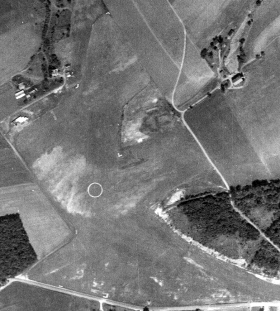
The earliest photo which has been located of Gordon Airport was an 8/29/58 aerial view.
It a north/south grass runway, with possibly 2 other shorter grass runways, with a prominent airport circle marking in the center.
A few small buildings were located on the northwest side, but no aircraft were visible on the field.
Ed Fritz reported, “My dad took me to [Gordon Airport] as a kid, 55 years ago [circa 1964]. I recall a few hangars still standing.”
Tom H. recalled, “I have memories as a little boy (early to mid-1960s) of going there with my family to move my uncle's Piper Cub from Gordon Airport.”
The last aeronautical chart depiction which has been located of Gordon Airport was on the April 1970 NY Sectional Chart.
It depicted Gordon Airport as having a 2,200' unpaved runway.
The last photo which has been located of Gordon Airport was an 8/12/71 aerial view.
It a north/south grass runway, with possibly 2 other shorter grass runways, with a prominent airport circle marking in the center.
A few small buildings were located on the northwest side, but no aircraft were visible on the field.
Gordon Airport was evidently closed (for reasons unknown) at some point between 1970-73,
as it was no longer depicted on the January 1973 NY Sectional Chart (courtesy of Ron Plante).
Ed Fritz reported, “I visited the Gordon airfield & hangars & old frayed windsock about 20 years ago [circa 1999].”
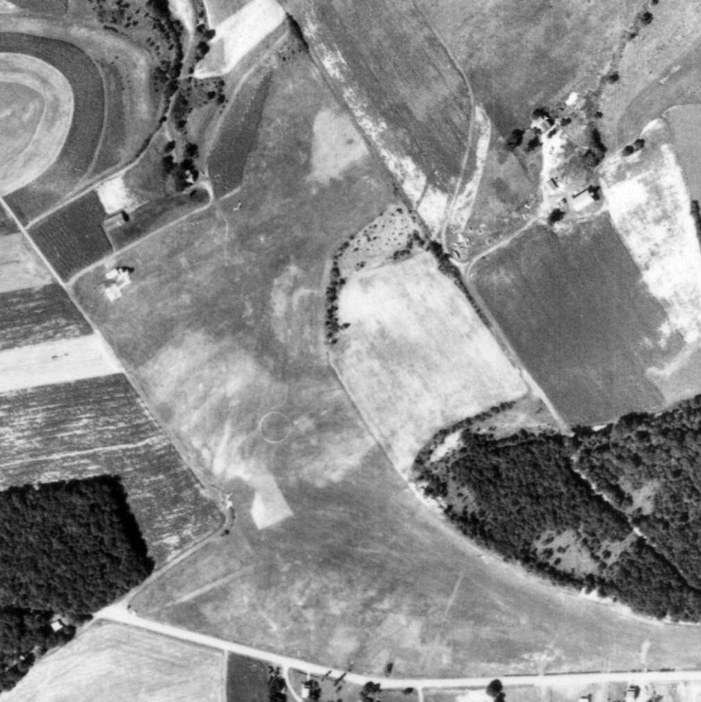
A 2016 aerial view showed the majority of the Gordon Airport site remained open farm land.
A building had been built over the southern portion of the airfield at some point between 1971-2016.
Tom H. reported in 2020, “The building over the southern portion of the airfield is a church. The building on the northwest side is a barn.
The airport hangars were across the road, to the south of the church, maybe 150 to 200 yards off the road.
I think the hangars are all torn down now.”
The site of Gordon Airport is located north of the intersection of Airport Road & Hangar Lane, appropriately enough.
Thanks to Ed Fritz for pointing out this airfield.
____________________________________________________
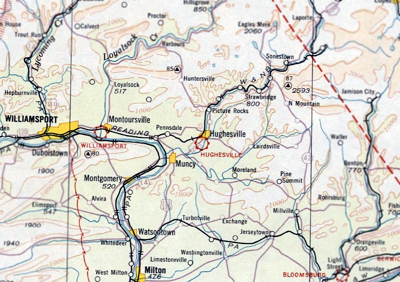
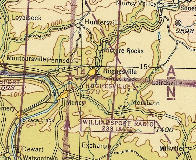
Hughesville Airport, Hughesville, PA
41.233, -76.726 (Northwest of Philadelphia, PA)
Hughesville Airport, as depicted on the April 1933 NY Sectional Chart.
The Hughesville Airport was constructed adjacent to the Lycoming County Fairground.
According to Wikipedia, “A special edition to the fairgrounds was an airplane landing field. Construction of hangars & a 1,700' runway was completed.
On 5/14/29, Amelia Earhart of Transatlantic flight fame, made an emergency landing in her plane at the landing field on the Hughesville Fairgrounds.
Earhart had intentions of landing at Bellefonte for refueling but lost her way. She noticed then landing field in the middle of the fairgrounds & took advantage of it.
The official opening and dedication took place on September 3-5, 1930.
The Hughesville Airport was considered an important refueling stop on a direct route between New York City & Cleveland.
In 1934, state & federal monies made improvements to the facility. The US Postal Service declared a special 'Air Mail Day' on 5/19/38 to honor the Hughesville Fairgrounds Airport.”
Hughesville Airport was not yet depicted on the August 1932 NY Sectional Chart.
The earliest depiction which has been located of Hughesville Airport was on the April 1933 NY Sectional Chart,
which depicted Hughesville as a commercial/municipal airport.
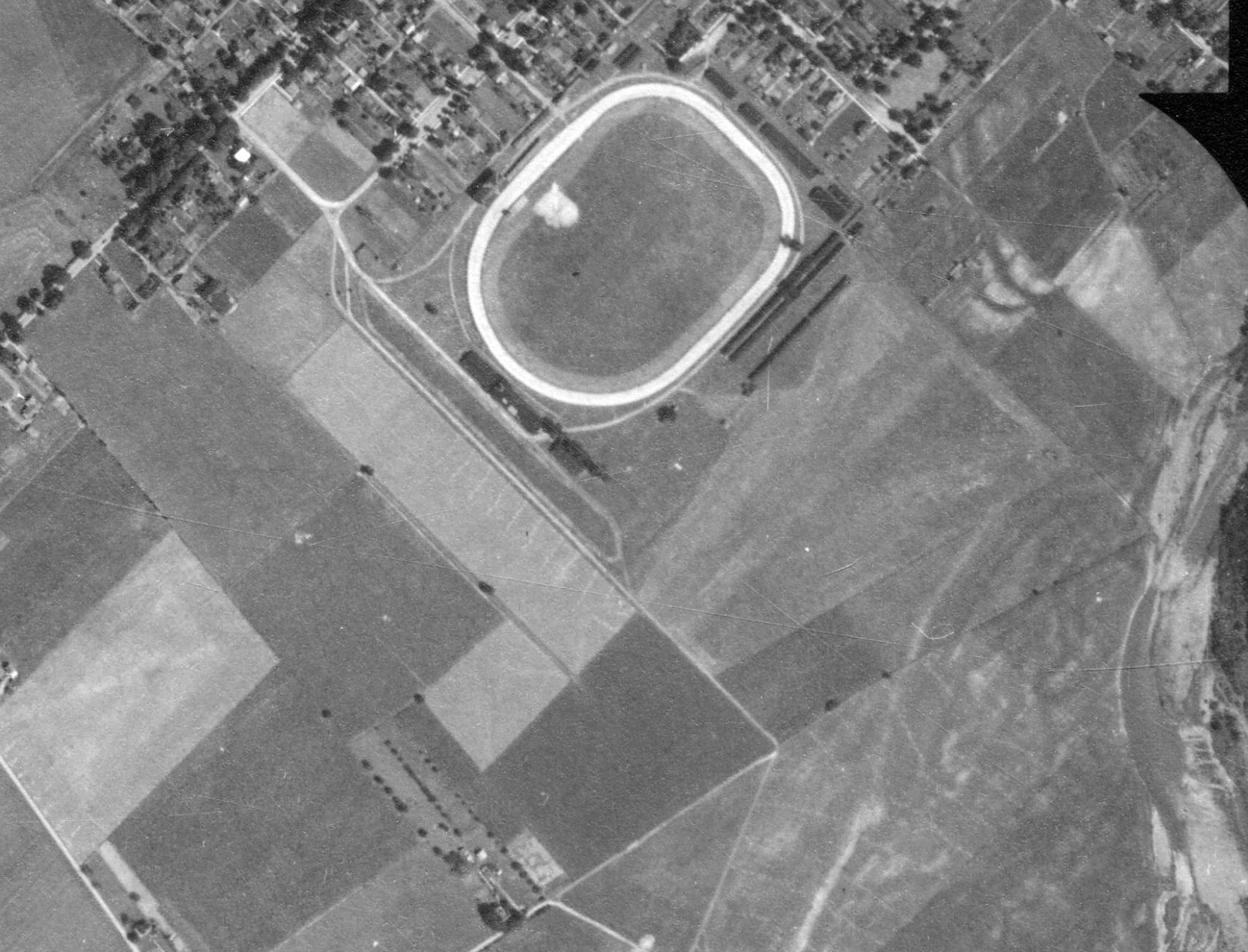
The earliest photo which has been located of Hughesville Airport was an 8/3/38 aerial view.
The last depiction which has been located of Hughesville Airport was on the January 1945 NY Sectional Chart.
Hughesville's depiction had been downgraded to that of an auxiliary airfield.
According to Wikipedia, “The years following World War II brought several changes in operation & the airport was soon abandoned.
Very little use of the airport was made after the war.
Soon the hangars were removed & the area was used for a variety of purposes, including a parking area for fair patrons.”
A 5/25/59 aerial view did not show any recognizable trace of Hughesville Airport.
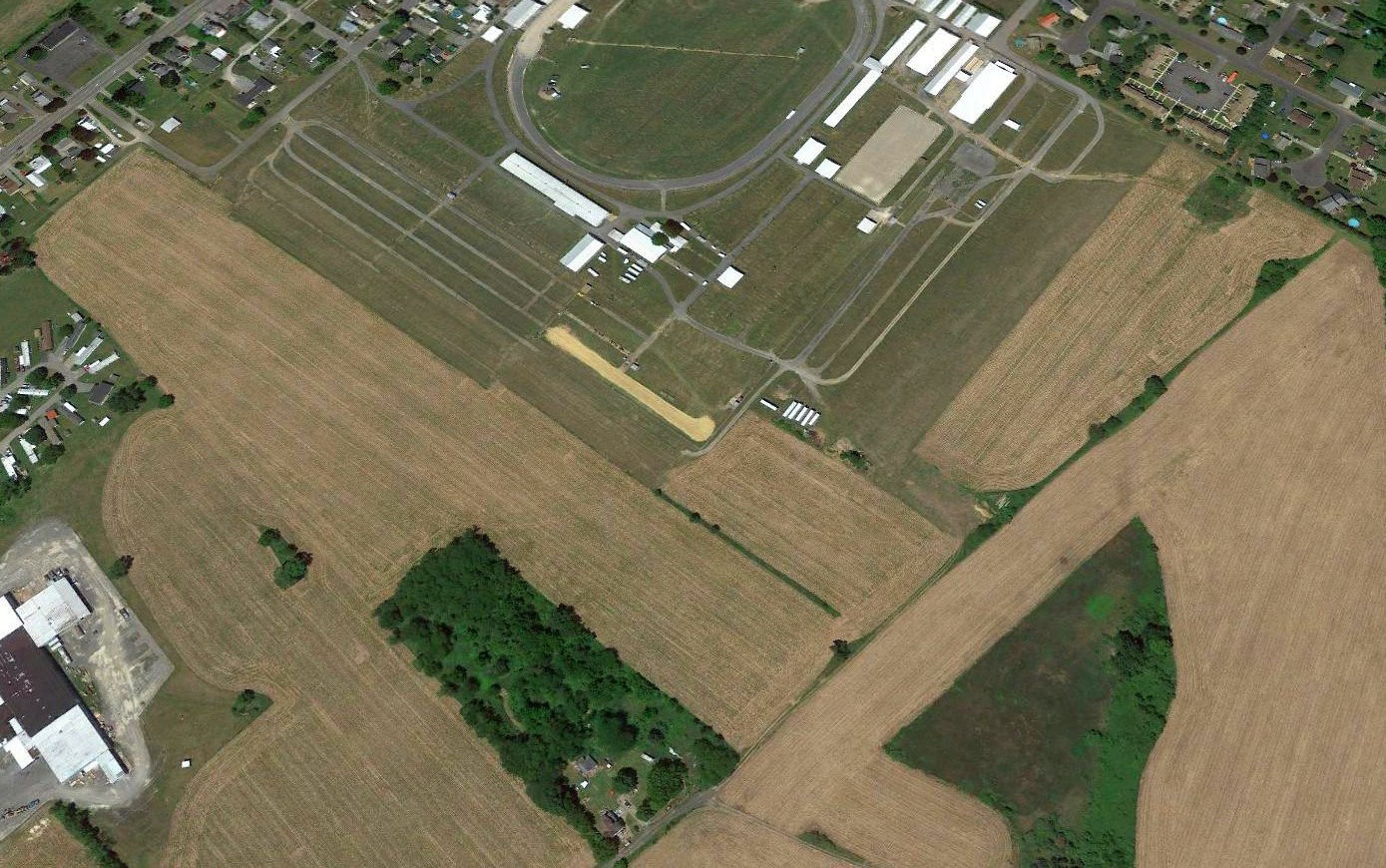
A 2016 aerial view looking north did not show any recognizable trace of Hughesville Airport.
Thanks to Dennis Kepner for pointing out this airfield.
____________________________________________________
Bellefonte Airport (original location) / Spring Township Airport, Bellefonte, PA
40.903, -77.749 (Northwest of Philadelphia, PA)
A circa 1920s photo of a Travel Air 5000 in front of a hangar at Bellefonte Airport.
The original airport for the town of Bellefonte was located to the east of the town.
According to the Bellefonte Historical & Cultural Association,
“Before the U.S. Post Office Air Mail Service, little could be called scheduled air delivery.
A few nonscheduled routes operated between major cities, but no national commitment existed for mail delivery by air.
Then came the end of World War I, and the post office declared its intention to establish a cross-country airmail route.
The Army Signal Corps offered to initiate the service.
Three months after the inaugural flight on 5/15/18, the post office took over from the Army & continued the service.”
The Bellefonte Historical & Cultural Association continued, “Airmail pilots were the glamour boys of the operation.
A breed apart, they were the envy of every kid in the nation who could look up & see a lonely biplane with 'U.S. Mail' painted on its fuselage winging its way across the sky.
They were the by-the-seat-of-their-pants fliers, the helmet & goggle boys who felt the wind when they flew & heard it singing through the wires & drumming on the fabric of their wings.
These earliest of the winged couriers flew as odd an assortment of planes as had ever been assembled.
At one time or another the Air Mail Service tried more than 20 types, ranging from German Junkers to Curtiss 'Jenny' trainers & World War I bombers.
They settled on the British-made de Haviland-4.”
The Bellefonte Historical & Cultural Association continued, “During the first years of Air Mail Service, the lessons came fast.
Statistics tell the story. In 1921, P.O. officials recorded 1,764 forced landings, about half due to mechanical failures & half due to weather.
In that same year, 12 pilots were killed. In all, 32 pilots lost their lives in the 9 years of service, approximately one 1 of every 6 employed.
Determined, however, to prove the mail could be borne on wings despite the hazards, they created milestones that led the way to today's space-age wonders.”
The Bellefonte Historical & Cultural Association continued, “From 1919-27 Bellefonte was a major refueling stop for mail traveling from NY to Chicago.
Flying the fog-shrouded ridges of the Allegheny Mountains in one of the early biplanes with the most primitive of navigational equipment
(one pilot famously used a half-empty whiskey bottle strapped to the dash to tell when his wings were level)
was a feat of incredible daring & skill - 6 pilots would lose their lives flying what was popularly known as the 'Hell Stretch' between 1919-27.
The initial stop on the first scheduled westbound air mail flight was made in Bellefonte by pilot Leon Smith on 12/18/18.
The site for the field was chosen by pioneer aviator Max Miller.”
The earliest depiction which has been located of Bellefonte Airport
was a circa 1920s photo of a high-wing monoplane (model unidentified) in front of a hangar.
A circa 1920s photo of 3 de Haviland DH.4 biplanes next to the Bellefonte Airport hangar.
A circa 1920s photo of a de Haviland DH.4 biplane next to the Bellefonte Airport hangar.
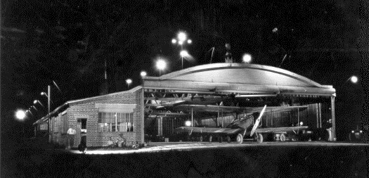
A circa 1920s nighttime photo of a de Haviland DH.4 biplane inside the Bellefonte Airport hangar.
According to the Bellefonte Historical & Cultural Association, “The site for the field was in regular use for air mail until 1925.”
The earliest aeronautical chart depiction which has been located of Bellefonte Airport was on the August 1932 NY Sectional Chart.
Benjamin Jones recalled, “Bellefonte Airport... I was a student at Penn State from 1949-51, and we had a flying club with about 40 members & 3 aircraft which were based there.
The pictures of the hangar are definitely the Bellefonte Airport from which we based.
The lean-to to the left of the door contained the office. In a room at the back of the hangar were several OX5 engines.
Parts of biplanes, wings & fuselages, were stored in the rafters. On the roof was a beacon light which was long since inoperative.
During my last year, the management largely disappeared, and no fuel was available. We ferried gas cans from Lock Haven.”
The July 1951 NY Sectional Chart depicted Bellefonte Airport as having a 2,100' unpaved runway.
Bellefonte Airport was evidently renamed Spring Township Airport at some point between 1951-52,
as that is how it was labeled on the January 1952 NY Sectional Chart.
The last aeronautical chart depiction which has been located of Spring Township Airport was on the January 1953 NY Sectional Chart.
Spring Township Airport was evidently closed (for reasons unknown) at some point in 1953,
as it was no longer depicted on the July 1953 NY Sectional Chart.
At some point between 1961-71 another Bellefonte Airport was constructed several miles to the southwest of the town.
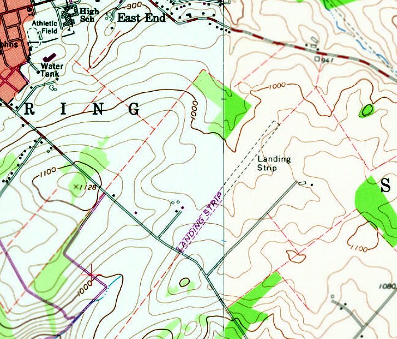
The 1966 USGS topo map depicted a single unpaved 3,500' northeast/southwest runway at the location of the original Bellefonte Airport, with a few small buildings on the west side.
It was labeled generically as “Landing Strip”, which typically means it was not in operation by that point.
According to the Bellefonte Historical & Cultural Association, “On 5/15/05,
the American Philatelic Society celebrated the heroic era of the pioneer air mail pilots with the dedication of a monument in their honor.
The granite monument, erected at the confluence of Logan Branch and Spring Creek, beside the American Philatelic Center (a half-mile west of the Bellefonte Airport site),
was the gift of Paul Mulvehill, a former pilot with a passion for air mail.
The artist who designed the monument was Mike Newcomer.”
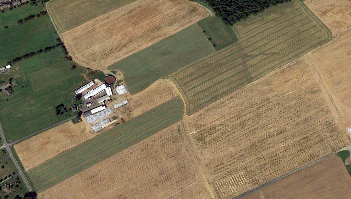
A 2015 aerial view looking northwest showed the northeast/southwest alignment of the former Bellefonte Airport runway was still apparent in the farmed fields.
The former hangar was possibly located near the cluster of current-day farm buildings on the west side of the runway.
Thanks to Joe Guzzo for pointing out this airfield.
____________________________________________________
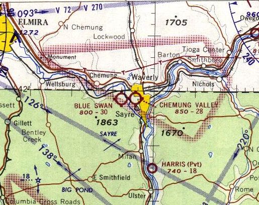
41.99, -76.56 (Northwest of Philadelphia, PA)
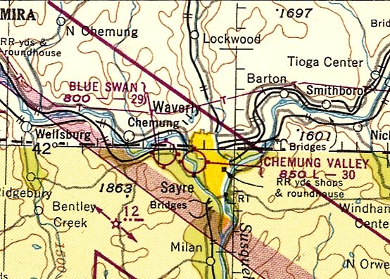
Blue Swan Airport, as depicted on the July 1949 NY Sectional Chart (courtesy of Ron Plante).
This small general aviation airport was evidently established at some point between 1945-54,
as it was not yet depicted on the January 1945 NY Sectional Chart (courtesy of Ron Plante).
The earliest depiction which has been located of Blue Swan Airport
was on the July 1949 NY Sectional Chart (courtesy of Ron Plante).
It depicted Blue Swan Airport as having a 2,900' unpaved runway.
John Neiley recalled, “Blue Swan Airport... the manager in the 1950s through the 1970s was Dana Smith.
The Civil Air Patrol had a plane based there in the 1950s.
Sailplane pilots out of Harris Hill in Elmira NY used to fly along cliffs near Waverly, land at Blue Swan,
and then get a free meal at O'Brien's Restaurant for the show they put on for its customers.
I enjoyed the airport as a kid.”
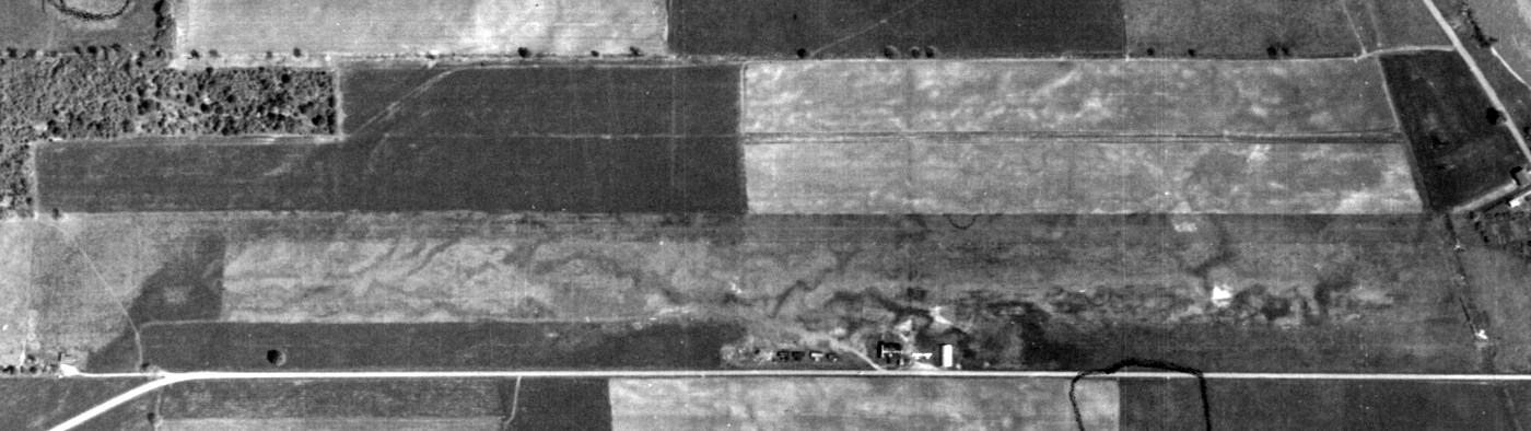
The earliest photo which has been located of Blue Swan Airport was a 5/16/60 USGS aerial view.
It depicted Blue Swan as having a single unpaved east/west runway, with a few small buildings, T-hangars, and at least 2 light single-engine aircraft on the south side.
The 1965 NY Sectional Chart depicted Blue Swan Airport as having a 3,000' unpaved runway.
Brian Stoller recalled, “My dad kept his airplanes at Blue Swan from 1965-75 & we often flew most every weekend.
The proprietors name was 'Dana' & I think the last name was Young. I remember that grass strip fondly.
My dad learn to fly from the G.I. Bill after World War II & was a private pilot.
We owned a Piper Cub & a later a Piper Clipper. These planes were parked at Blue Swan.”
A 10/30/69 USGS aerial view depicted Blue Swan Airport at perhaps the zenith of its popularity,
with a dozen light single-engine aircraft on the south side of the field.
According to Nathan Milarta, “They had a few airshows there back in the 1980s.”
The last photo which has been located showing aircraft at Blue Swan Airport was a 1995 USGS aerial view,
on which 2 light single-engine aircraft were parked on the south side.
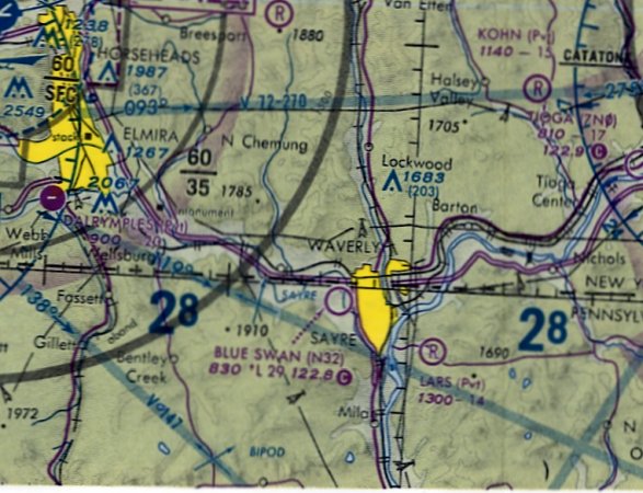
The earliest depiction which has been located of Blue Swan Airport was on the December 1993 NY Sectional Chart (courtesy of Ron Plante).
It depicted Blue Swan Airport as having a 2,900' unpaved runway.
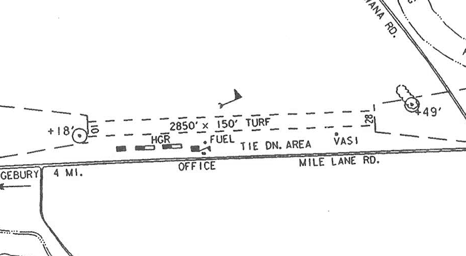
The last airport directory listing which has been located of Blue Swan Airport was in the 1997 PA Airport Directory (courtesy of John Clifford).
The directory described Blue Swan as having a 2,850' turf Runway 10/28.
It listed the licensee as the Borough of Sayre, the operator as Independent Aviation Inc., and the manager as Scott Jewell.
Nathan Milarta reported in 2017, “The last time I remember any airplanes on the airport was in the early 2000s - only one small ultralight.
There was a factory that was built behind Blue Swan and I think that killed off the airport.
It's a real shame the airport went away.”
Blue Swan Airport was evidently closed (for reasons unknown) at some point between 1997-2005,
as a 2005 aerial view showed closed-runway “X” symbols on the runway.
The hangars remained intact, but no aircraft were visible.
John Neiley recalled, “Blue Swan Airport... closed when Chesapeake Gas & Oil took over & built several buildings during the drilling operations for natural gas.”
A 2008 aerial photo showed 1 of Blue Swan's hangars had been removed at some point between 2006-2008.
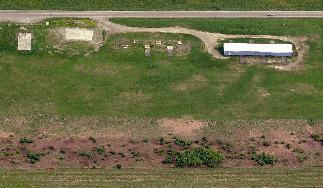
A circa 2010 aerial view looking south at the sole remaining hangar at the site of Blue Swan Airport.
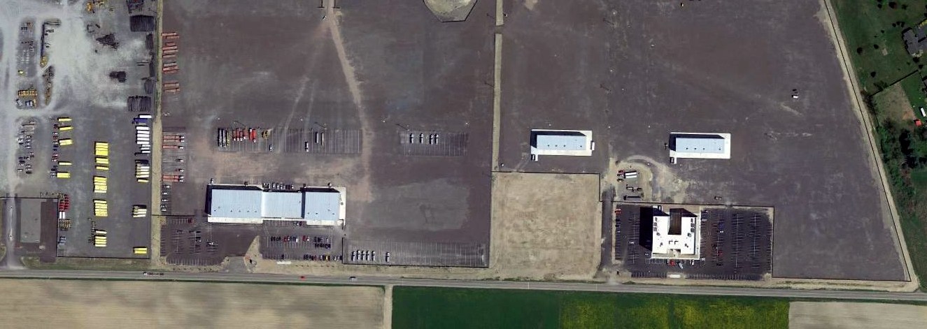
A 9/15/10 Daily Review article said that Chesapeake Energy was looking to purchase the decommissioned Blue Swan Airport property
from the Borough of Sayre to use as the company's eastern regional headquarters.
Nathan Milarta reported in 2017, “Back in 2010-2013 a natural gas drilling company built up office buildings & garages on the former blue Swan Airport (I was in charge of cleaning all the buildings).”
A 2011 aerial view showed the western hangar was the only one remaining, although the runway remained clear.
A 2013 aerial view showed that all traces of Blue Swan Airport had been removed at some point between 2011-2013.
Yet another of the many small PA general aviation airports erased forever from the landscape.
Nathan Milarta reported in 2017, “I currently work on the former Blue Swan Airport grounds.
There are still orange power line ball markers along the road leading to the old runway.”
John Neily reported in 2018, “Chesapeake has basically abandoned the area with some buildings being bought by other enterprises.”
The site of Blue Swan Airport is located northeast of the intersection of Mile Lane Road & Lamoka Road.
Thanks to John Clifford for pointing out this airfield.
____________________________________________________
Valley Airport / Chemung Valley Airport / Coles Airport, Sayre, PA
41.99, -76.54 (Northwest of Philadelphia, PA)

Valley Airport, as depicted on the November 1942 NY Sectional Chart.
This small general aviation airport was evidently established at some point in 1942,
as it was not yet depicted on a 1939 aerial photo or the May 1942 NY Sectional Chart.
The earliest depiction which has been located of Valley Airport was on the November 1942 NY Sectional Chart,
which depicted Valley as a commercial/municipal airport.
It was still depicted as Valley Airport on the 1945 NY Sectional Chart.
The airport was evidently renamed Chemung Valley Airport at some point between 1945-49,
as that is how it was labeled on on the July 1949 NY Sectional Chart (courtesy of Ron Plante).
Chemung Valley Airport was depicted as having a 3,000' unpaved runway.
It was depicted as Valley Airport on the 1954 USGS topo map.
Nathan Milarta reported, “My Great Uncle Don told me once he worked as an aircraft mechanic at Chemung Valley Airport.
He was a aircraft mechanic in WW2, and shortly after the war he got his private pilots license.
I have never heard the term Chemung Valley Airport. My Uncle used to call it Coles Airport.
Blue Swan & Coles Airport are less then a mile apart & I remember my uncle saying that Blue Swan had a left-hand traffic pattern & Coles/Chemung had a right-hand traffic pattern.”
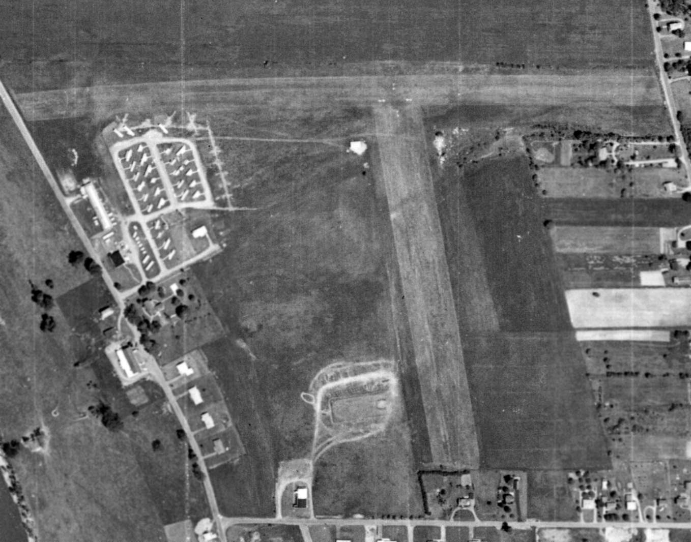
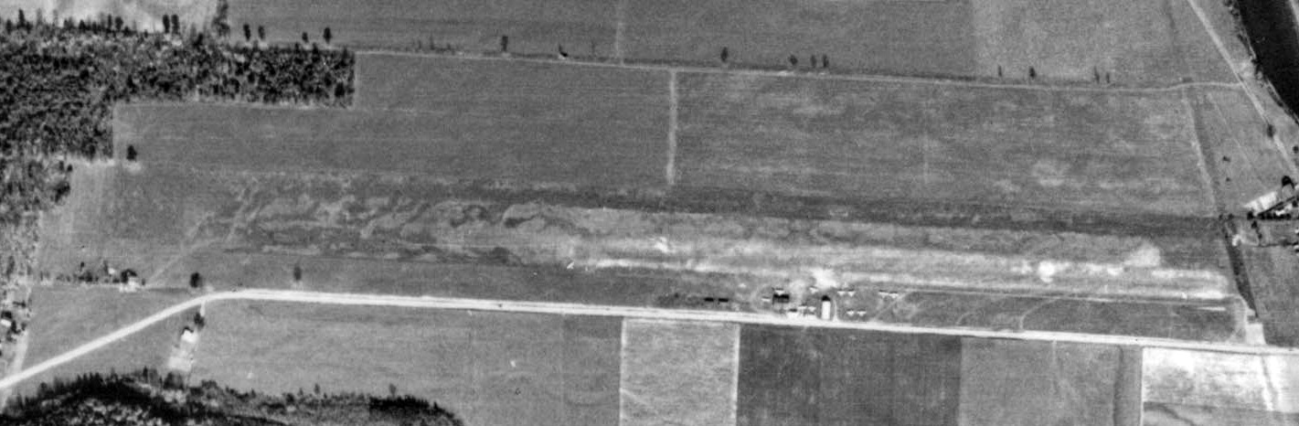
The earliest photo which has been located of Valley Airport was a 6/20/60 USGS aerial view.
It depicted Valley Airport as having 2 unpaved runways. There were a few small buildings, but no aircraft visible on the field.
The 1965 NY Sectional Chart depicted Chemung Valley Airport as having a 2,800' unpaved runway.
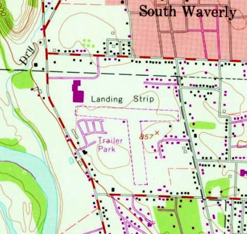
The 1969 USGS topo map depicted 2 unpaved runways, labeled simply as “Landing Strip”.
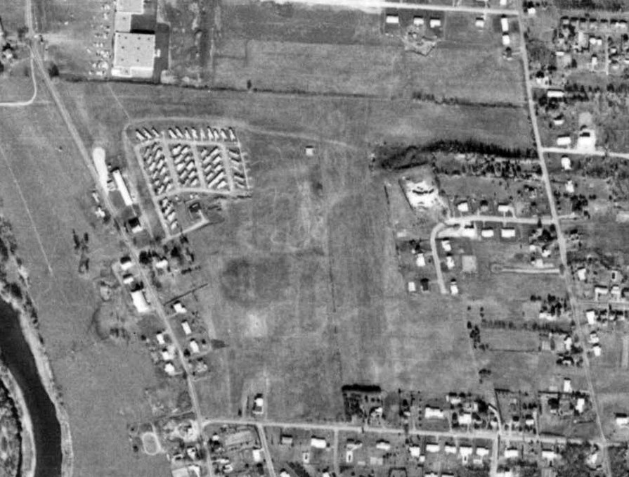
The last photo which has been located of Chemung Valley Airport was a 10/3/69 USGS aerial view.
Although the 2 runways remained clear, there were no aircraft visible nor any other signs of recent aviation usage.
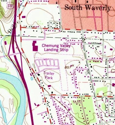
The last depiction which has been located of the airport was on the 1986 USGS topo map,
which depicted 2 unpaved runways labeled as “Chemung Valley Landing Strip”.
Chemung Valley Airport was evidently closed at some point between 1986-94,
as a 1994 USGS aerial photo showed houses covering the site of both runways.
A 2013 aerial view showed houses covering the site of Chemung Valley Airport.
Nathan Milarta reported in 2017, “Most people today have no idea there was an airport there.
There is a K-Mart & trailer park there now at the former airport.
Its really odd though that there is still an orange marker ball on one of the power lines on the street in front of the former south end runway.”
The site of Chemung Valley Airport is located at the intersection of Cessna Street & Piper Avenue, appropriately enough.
Thanks to Aaron Weintraub for pointing out this airfield.
____________________________________________________
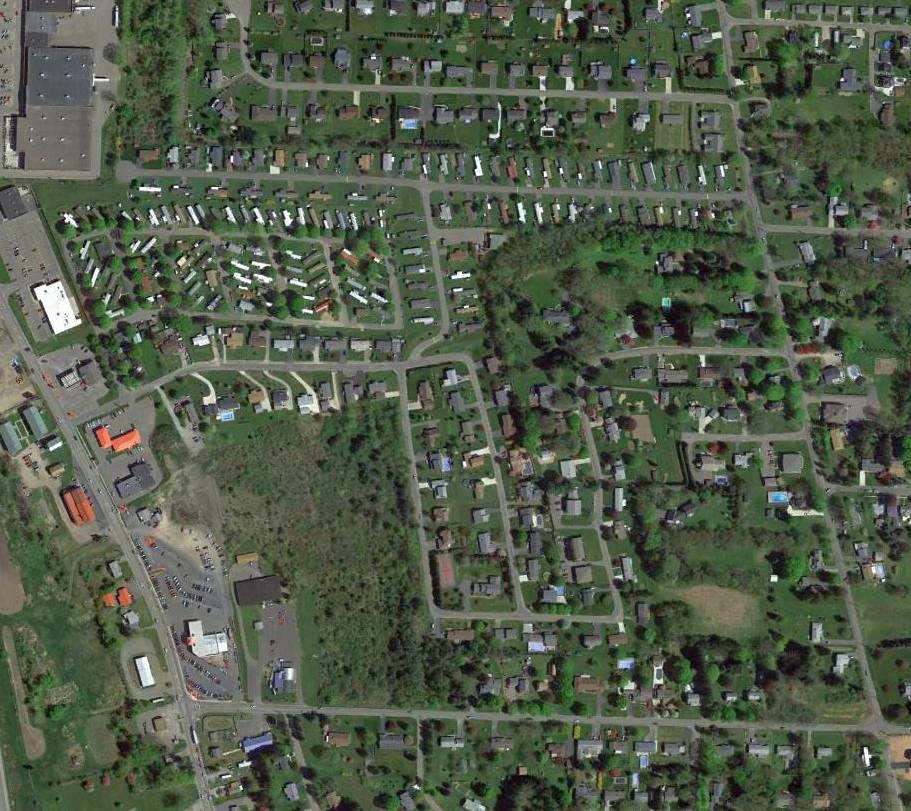
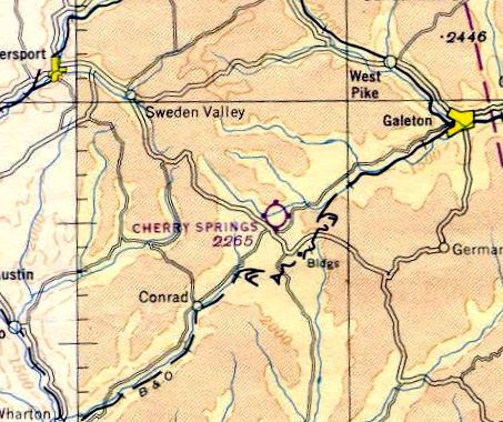
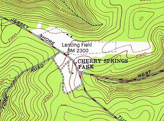
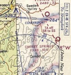
Cherry Springs Intermediate Field / Cherry Springs Airport (5G6), Cloudersport, PA
41.665, -77.82 (Northeast of Pittsburgh, PA)
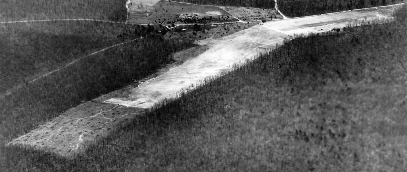
A 5/11/37 aerial view looking southwest at Cherry Springs Airport (from the Dallin Aerial Survey Collection, courtesy of the Hagley Museum & Library).
According to Wikipedia, Cherry Springs Intermediate Field was built for emergency landings in 1935 by the Pennsylvania Department of Forests & Waters as a 40-acre airfield.
In 1936 Cherry Springs had a 2,400' sod runway & a hangar.
The earliest depiction which has been located of Cherry Springs Airport was a 5/10/36 aerial view (from the Dallin Aerial Survey Collection, courtesy of the Hagley Museum & Library).
It depicted the field as having 2 unpaved runways, with a few small buildings on the southwest & northwest sides.
Cherry Springs was listed as a "State Emergency" airport in 1938, but eventually became a small general aviation airport.
The land belonged to the Bureau of Forestry, while the airport was privately managed.
The earliest aeronautical chart depiction which has been located of Cherry Springs Airport was on the 1945 NY Sectional Chart.
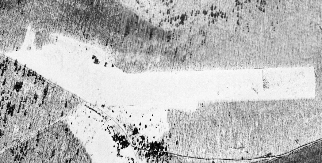
A 3/1/45 USGS aerial view depicted Cherry Springs Airport as having 2 unpaved runways, with a few small hangars on the northwest side.
The 1947 USGS topo map depicted Cherry Springs “Landing Field”
as having an unpaved east/west runway, with a few small hangars on the northwest side.
In 1948 Cherry Springs Airport was managed by Alfred Sallade & offered 80 octane fuel, flight training, sales, and taxi service.
On 9/2/52, Cherry Springs Airport manager Alfred Sallade was arrested for fatally shooting Charles Van Pelt & seriously wounding Erwin Bergdoll.
Both victims were walking in the park near the airport office when Sallade shot them with a shotgun.
Sallade reported that he thought the victims were the people who had robbed his office twice in the recent past, but was convicted of manslaughter.
Cherry Springs Airport was home to the Sallade Flying School in from 1964-90.
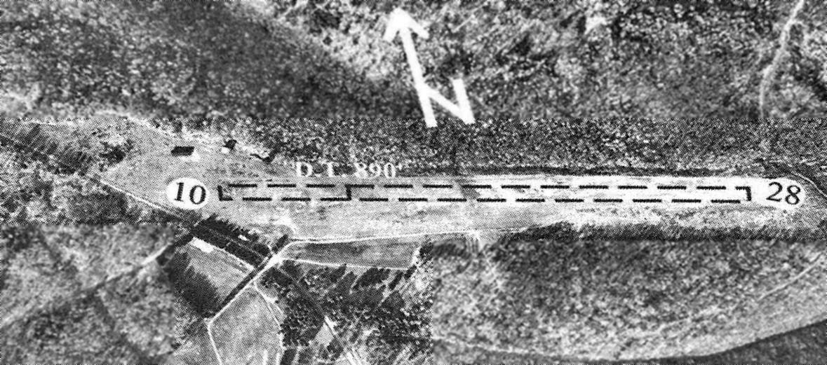
The last aeronautical chart depiction which has been located of Cherry Springs Airport was on the 1968 Cleveland Sectional Chart.
It depicted Cherry Springs as having a 4,000' unpaved runway.
In 1981 the airport had expanded from the original 40 acres to an area of 59 acres.
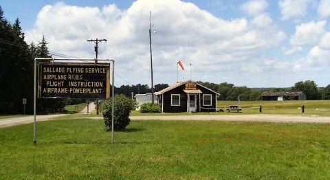
A 2004 photo depicted the office of Sallade Flying Service at Cherry Springs Airport.
In 2005 there were only 2 aircraft based at the airport, and local aircraft accounted for 50 of the total 150 takeoffs or landings that year.
The last airport directory listing which has been located of Cherry Springs Airport was in the 2005 PA Airport Directory (courtesy of John Clifford).
The directory described Cherry Springs as having a 3,570' turf Runway 10/28, and listed the manager as Al Sallade Jr.
In 2006 the Cherry Springs Airport manager was Al Sallade, Jr. and it was home to Sallade Flying Service.
The field had a 3,570' turf runway, marked with yellow cones & barrels.
The airport had a hangar & tie downs available for aircraft storage, as well as wind direction indicator.
The Pennsylvania Department of Conservation & Natural Resources acquired the Cherry Springs Airport in 2006
"to expand the overall Dark Sky observation area & allow for increased programming opportunities", and the airport closed in 2007.
The airport site had become popular with astronomers because of its dark skies, which make it one of the best places to stargaze in the eastern United States.
As of 2009 all of the airport buildings had been razed.
An amphitheater for public stargazing programs was built on the former runway,
as well as raised earth berms to shield the stargazers from the headlights of passing cars.
A 2009 photo looking east along Cherry Spring's former runway.
An 8/30/12 aerial view looking northeast at the site of Cherry Springs Airport.
The site of Cherry Springs Airport is located northeast of the intersection of Route 44 & West Branch Road.
____________________________________________________
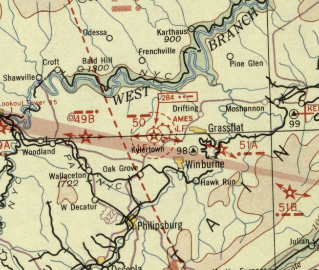
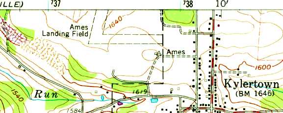
Ames Airport, Kylertown, Hyner, PA
41, -78.18 (Northeast of Pittsburgh, PA)
Ames Airport, as depicted on the December 1932 Cleveland Sectional Chart.
This small general aviation airport was evidently established at some point between 1922-32,
as it was not yet depicted on the 1922 USGS topo map.
The earliest depiction which has been located of Ames Airport was on the December 1932 Cleveland Sectional Chart.
It depicted Ames as a commercial/municipal airport, with the Commerce Department's Airway Beacon #50 located adjacent to the southwest.
Ralph Bennett reported, “The field was named in honor of USPS Pilot Charles Ames who was killed when he flew into Mount Nittany (near State College) on 10/1/25 in a DH4.
The Ames Airfield was located along his NY-Cleveland route. His fatal crash helped to create the Kollsman window of the sensitive altimeter.”
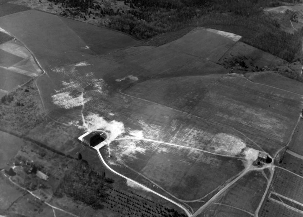
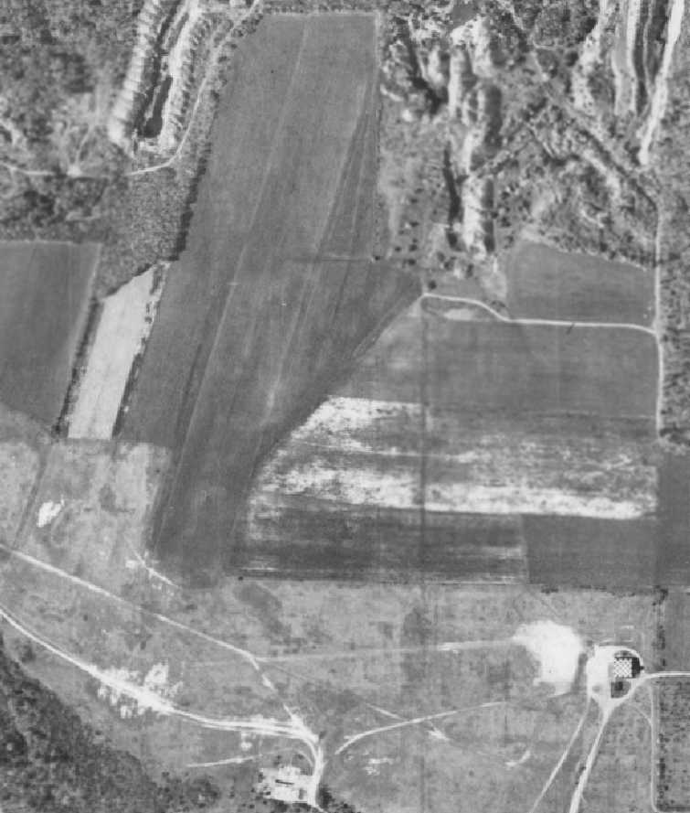
The earliest photo which has been located of Ames Airport was a 5/11/37 aerial view looking north.
It depicted Ames as having 2 grass runways, with an airport circle marking in the intersection.
One hangar was located on the southeast side, and another possible hangar was located on the south side.
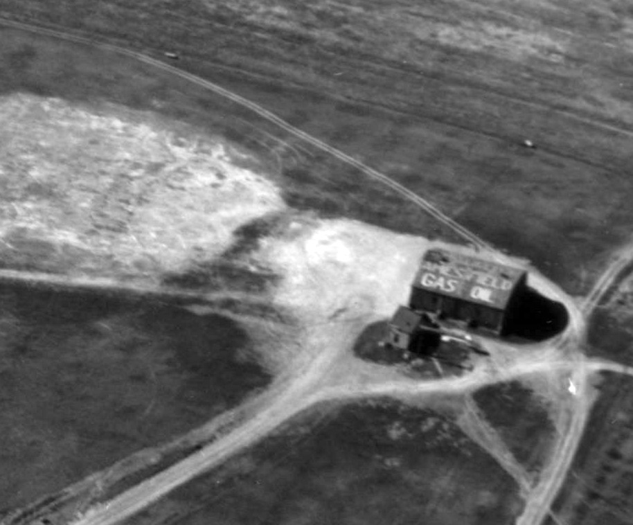
A closeup from the 5/11/37 aerial view looking north at Ames Airport,
showing the hangar on the southeast side with “Ames Field Gas Oil” painted on its roof.
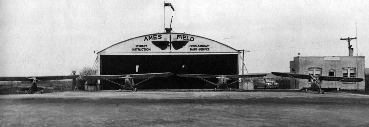
A circa late 1930s photo of 4 Pipers in front of the Ames Field hangar & office (courtesy of Thomas Kirk).
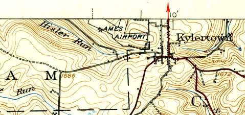
The 1939 USGS topo map depicted Ames Airport as having 2 runways adjacent to the northwest side of the town.
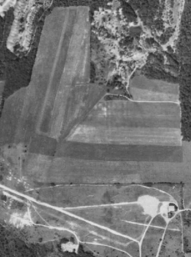
A 5/9/40 aerial view (from Penn Pilot) depicted Ames as having 2 grass runways, with an airport circle marking in the intersection.
A checkerboard-roof hangar was located on the southeast side, and another possible hangar was located on the south side.
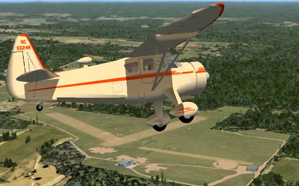
A flight simulation scenery re-creation of Ames Airport by Richard Finley, looking northwest at a Stinson Reliant overflying Ames Airport.
A 5/21/58 aerial view (from Penn Pilot) showed Ames as still having 2 grass runways, but the northwest/southeast runway on the west side (seen in the 1940 photo)
had been replaced with an east/west runway on the east side.
The checkerboard-roof hangar remained on the southeast side, but the possible hangar on the south side appeared to have been removed at some point between 1940-58.
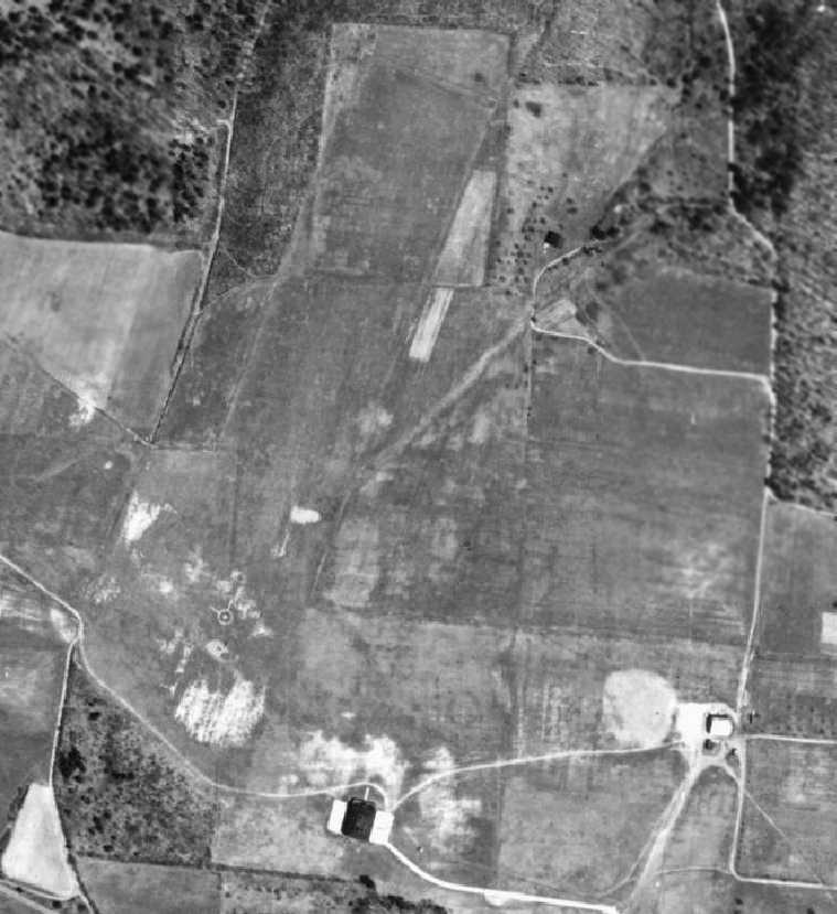
The last photo which has been located showing Ames Airport while open was an 8/21/68 aerial view (from Penn Pilot).
The 2 grass runways remained clear, and the checkerboard-roof hangar remained standing on the southeast side,
but there was no indication of any recent aviation usage.
The Ames Airport was evidently closed (for reasons unknown) by 1960,
as it was not depicted at all on the 1960 Cleveland Sectional Chart (courtesy of Mike Keefe).
The Ames Airport was evidently reopened at some point between 1960-68,
as it was once again depicted as an active airfield on the May 1968 Cleveland Sectional Chart (courtesy of Ron Plante).
The November 1968 Cleveland Sectional Chart (courtesy of Richard Finley) depicted Ames as a public-use airport having a 3,000' unpaved runway.
The 1971 USGS topo map still depicted “Ames Landing Field” as having 2 unpaved runways,
along with a survey marker named “Ames”.
The last aeronautical chart depiction which has been located of Ames Airport was on the November 1972 Detroit Sectional Chart (courtesy of Ron Plante).
It depicted Ames as a private airfield having a 3,000' unpaved runway.
Ames Airport was evidently closed (for reasons unknown) at some point between 1972-74
as it was no longer depicted on the November 1974 Detroit Sectional Chart (courtesy of Ron Plante).
On the 1981 USGS topo map, only the survey marker on the southeast side of the property, named “Ames”, remained to give any clue as to the property's past.
A 1993 USGS aerial photo showed that the hangar on the southeast side had been removed at some point between 1968-93.
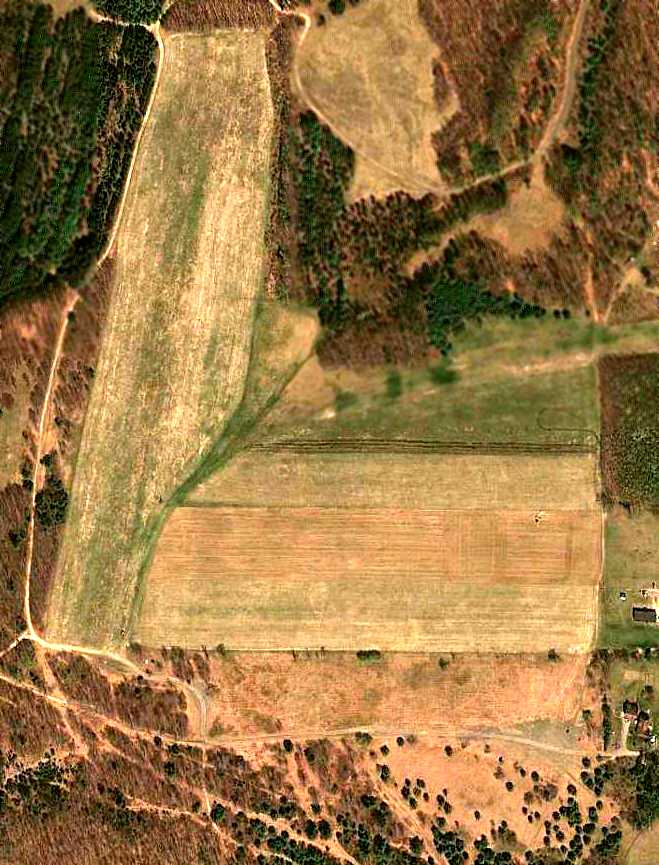
A 4/15/10 aerial view showed the outline of the 2 grass Ames runways remained clear more than 70 years after the airport's establishment.
The site of Ames Airport is located at the western terminus of Kyler Lane.
____________________________________________________
41.321, -77.635 (Northwest of Harrisburg, PA)
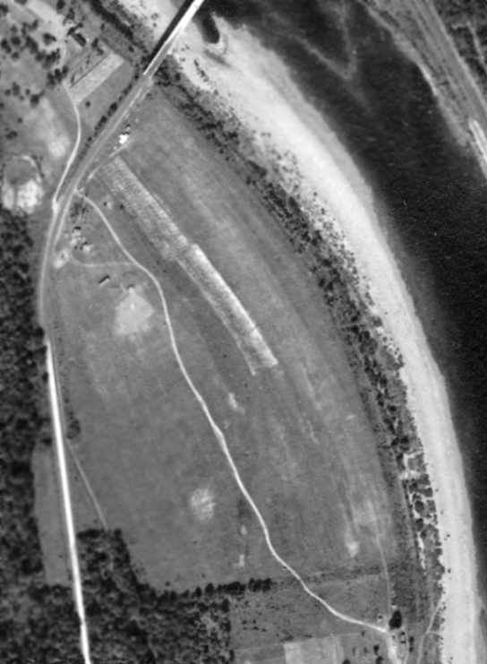
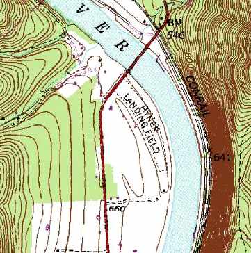
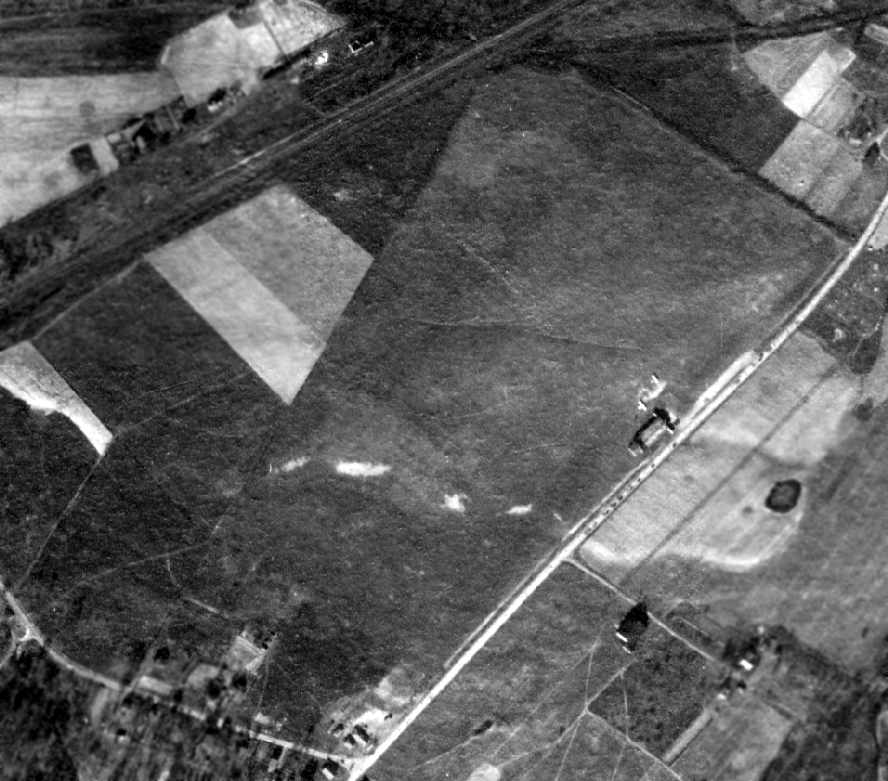
The earliest depiction which has been located of the Hyner Landing Field was a 10/2/1938 aerial photo.
According to Bob Beck, “I found a local historian who provided some information about Hyner Flying Field.
I was told it operated in the 1920s to 1930s & was used as an alternate mail route airport.
There were 2 airports (one in South Renovo, now the site of the Renovo Medical Center, and the one at Hyner).
There was a flying club that administered both fields, led by Paul Maxwell.
The field at Hyner had a T-hangar & clubhouse at the North end.”
Hyner Field was evidently somewhat obscure, though,
as it was not listed or depicted at all on the 1929 Rand McNally Air Trails Map,
the August 1932 NY Sectional Chart, The Airport Directory Company's 1933 Airport Directory,
or the 1934 Department of Commerce Airport Directory (according to Chris Kennedy).
According to Bob Beck, Hyner Field “was also used by the Civilian Conservation Corps
and was used to fly emergency supplies to the area during the flood of 1936.”
Hyner Field was not listed in The Airport Directory Company's 1937 Airport Directory (courtesy of Bob Rambo).
The earliest depiction which has been located of the Hyner Landing Field was a 10/2/1938 aerial photo.
It depicted the field as an open north/south grass area which curves to follow the shoreline of the adjacent Susquehanna River,
along with the T-hangar at the north end.
According to Bob Beck, “After Paul Maxwell was killed, it seems the local interest in aviation died with him & both fields fell into disuse.”
Hyner Field was not depicted among active airfields in the 1945 AAF Airfield Directory (courtesy of Scott Murdock).
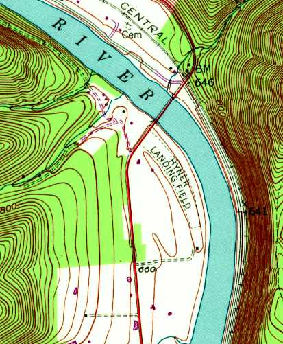
The earliest topo map depiction which has been located of the Hyner Landing Field was on the 1946 USGS topo map.
It depicted the field as an open north/south grass area which curves to follow the shoreline of the adjacent Susquehanna River, along with the T-hangar at the north end.
Hyner Field still was not yet depicted on the January 1947 NY Sectional Chart.
The earliest aeronautical chart depiction which has been located of the Hyner Field was on the July 1947 NY Sectional Chart.
It depicted Hyner as a commercial/municipal airport.
The last aeronautical chart depiction which has been located of the Hyner Field was on the January 1949 NY Sectional Chart.
It depicted Hyner Field as having an 1,800' unpaved runway.
Hyner Field was evidently closed (for reasons unknown) at some point in 1949,
as it was no longer depicted on the July 1949 NY Sectional Chart (or subsequent Sectionals from the 1950s/60s/70s/80s).
A 5/25/1959 aerial photo of Hyner Landing Field did not appear to show any evident signs of current use.
It depicted the field as an open north/south grass area which curves to follow the shoreline of the adjacent Susquehanna River, with the T-hangar still visible.
A 7/7/1968 aerial photo of Hyner Landing Field did not appear to show any evident signs of current use.
It depicted the field as an open north/south grass area which curves to follow the shoreline of the adjacent Susquehanna River.
The only map depiction of Hyner Field which has been located was on the 1986 USGS topo map.
It depicted “Hyner Landing Field” as consisting of a single 1,600' grass runway,
which curves to follow the shoreline of the adjacent Susquehanna River.
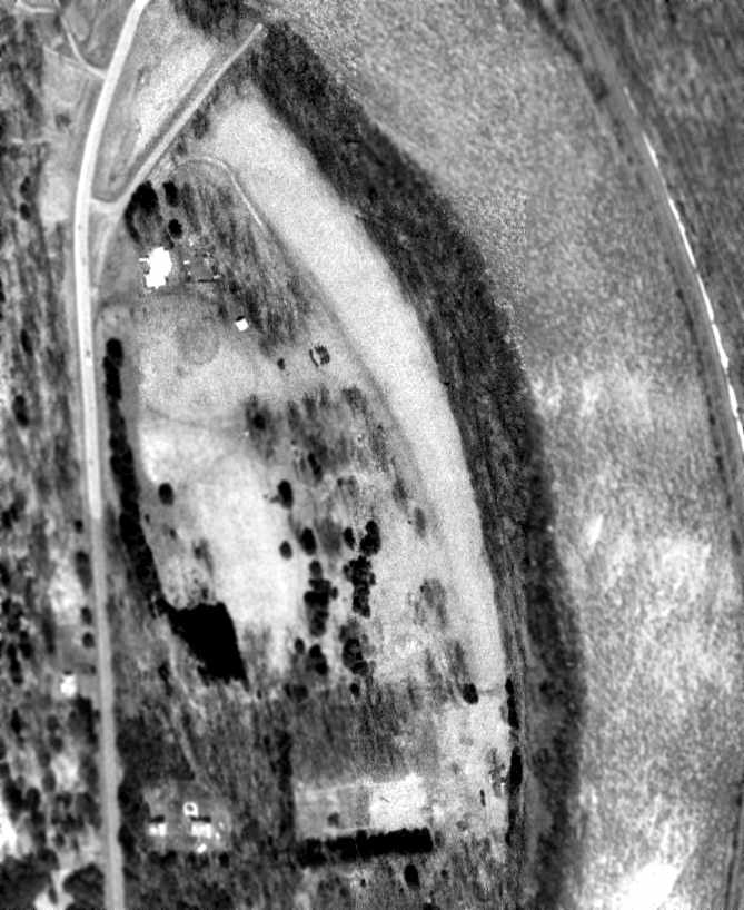
In the 1994 USGS aerial photo, the open area of the grass runway was still very recognizable.
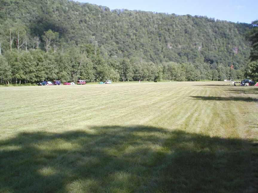
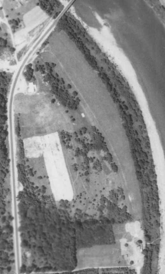
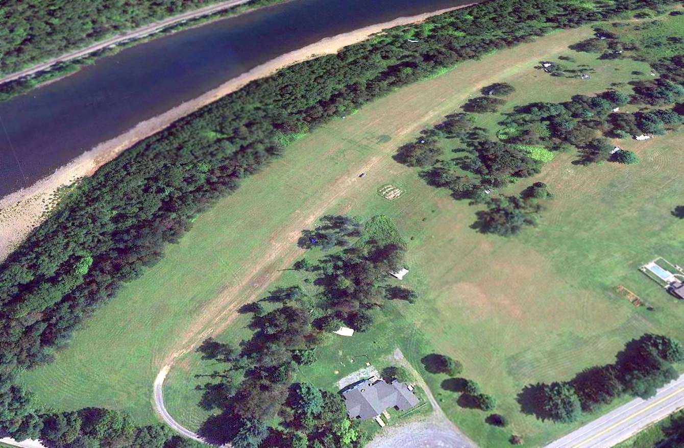
A 2005 aerial view by Bob Beck looking south at Hyner Field.
Bob reported in 2005 that Hyner is “Now used as landing field for hang gliders flying from Hyner View State Park scenic overlook.”
A 2005 aerial view by Bob Beck looking southwest at Hyner Field.
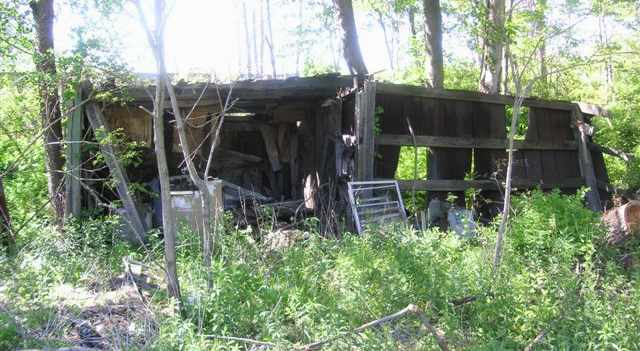
A 2005 photo by Bob Beck of “all that remains of the T-hangar & clubhouse.
This is the tail section of the Tee & the back wall of the left wing section.
The roof & walls are there but are settling into the ground with grass/weeds already growing on the remains. The rusted wind sock frame is gone.”
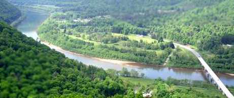
A 2012 aerial view looking southeast at the Hyner Field runway.
Hyner Field is located on the east side of Route 120, just south of the Susquehanna River.
____________________________________________________
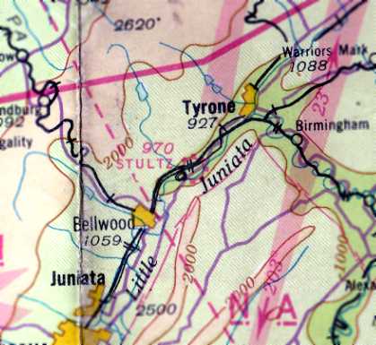
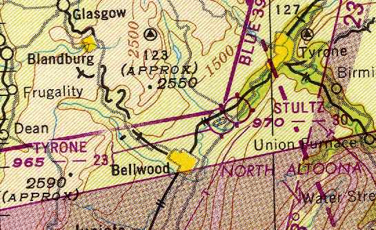
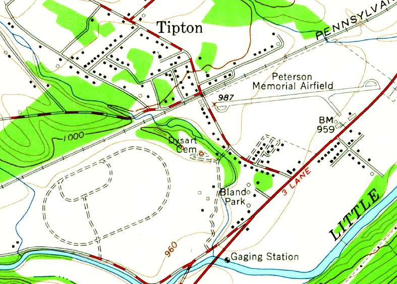
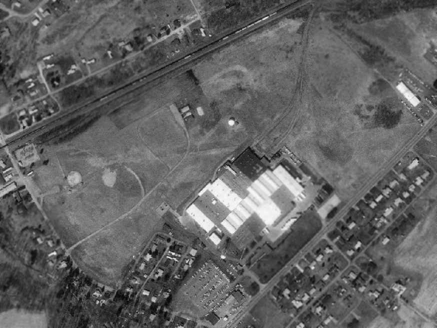
Stultz Field / Peterson Memorial Airfield (1st location), Tipton, PA
40.635, -78.288 (East of Pittsburgh, PA)
"Stultz Field", as depicted in the 1929 Rand McNally "Standard Indexed Map With Air Trails" (courtesy of Chris Kennedy).
According to Tom Beamer, "Peterson Memorial was originally Stultz Field,
operated by Wilmer Stultz - Amelia Earhart's pilot on her Trans Atlantic passenger flight/ride."
The date of construction of Stultz Field has not been determined.
The earliest reference to the field which has been located
was in the 1929 Rand McNally "Standard Indexed Map With Air Trails" (courtesy of Chris Kennedy).
It described "Stultz Field" as being operated by the Altoona Aircraft Corporation,
measuring 2,000' x 1,400', and having a beacon light.

The earliest aeronautical chart depiction which has been located of Stultz Field was on the December 1932 Cleveland Sectional Chart.
The 1934 Department of Commerce Airport Directory (according to Chris Kennedy)
described Stultz Field as having a 2,300' x 1,800' sod rectangular landing area,
and a hangar was said to have "Altoona-Tyrone" painted on the roof.
The Airport Directory Company's 1938 Airports Directory (according to Chris Kennedy)
described Stultz Field as having a 2,140' x 1,100' "Entire field available" landing area.
An 11/11/38 aerial view depicted Stultz Field as consisting of an open grass area,
with a single hangar on the southeast side, near which were visible 2 light aircraft.
A 1939 photo of Bill Slemmer Sr. & Joe Galloway in front of a Piper J-4A Cub Coupe with a Continental A65 engine at Stultz Field (courtesy of Bill Slemmer Jr.).
A 5/29/39 photo of an unidentified couple in front of a 1933 Waco UBF2, with a hangar in the background on which is marked "Altoona", "Tyrone", and "Stultz Field" (courtesy of Brian Miller).
A 5/29/39 photo of an unidentified man with a 1933 Waco UBF2 at Stultz Field (courtesy of Brian Miller).
Brian Miller reported, “The plane was bought brand new from the Waco plant in Troy, OH in 1933 to ferry passengers back & forth from Pinehurst, NC.
The airplane was beautifully restored & still gives scenic tours of the Norfolk area, as The Airplane [as of 2018].”
Stultz Field, as depicted on the March 1940 Cleveland Sectional Chart (courtesy of Richard Finley).
Mark Rutter recalled of Stultz Field, “My father Clair Rutter worked at the original airfield from 1942-60 as chief mechanic,
as well as instructor & charter pilot.”
The 1945 AAF Airfield Directory (courtesy of Scott Murdock) described Stultz Field
as a 95 acre rectangular property within which was a sod all-way landing field, measuring 2,300' ENE/WSW by 1,800' Nne/SSW.
The field was said to have a single 100' x 50' wooden hangar, and to be owned & operated by private interests.
A 1948 photo of Clair Rutter with the Stultz Field hangar in the background (courtesy of Mark Rutter).
The January 1949 Cleveland Sectional Chart (courtesy of Chris Kennedy) depicted Stultz Field as having a 3,000' unpaved runway.

A 1950 aerial view by Don Struke looking west at Stultz Field.
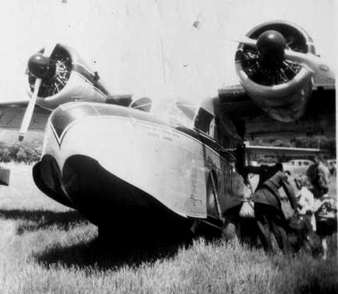
A 1950 photo by Marian Wills (courtesy of Don Struke) of a Grumman Goose at Stultz Field.
Don noted, “On the nose it says 'British American Oil Company Limited, Toronto, Canada'. I see Mr. Peterson was a little behind in his mowing.”
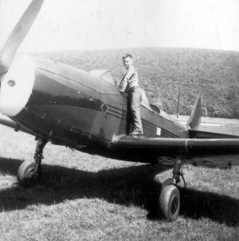
A 1950 photo by Marian Wills (courtesy of Don Struke) of Jerry Struke pretending to climb in a Fairchild PT-19 at Stultz Field.
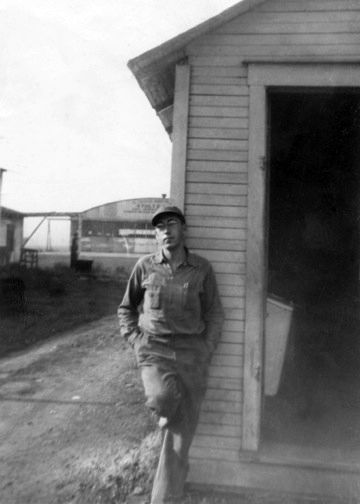
Paul Peterson Jr, the son of the owner of Stultz Field, was killed at the airport on 3/18/51 while hand-propping a Waco.
The airfield was renamed Peterson Memorial in his honor.
Don Struke, “Paul Peterson was 21 when he was killed & I think he slipped on frozen ground or ice while propping the Waco.
I flew in that plane a few years earlier as a delighted passenger.”

A 1951 photo by Don Struke of a Waco being hand-propped
in front of the hangar which had been newly painted with the field's new name of “Paul Peterson Memorial Field”.
Herman Nagle recalled, “Around 1951 my younger brother, Paul and I when we were 10 & 12 years of age
rode our bikes approximately 15 miles on a bright sunny Sunday morning from Altoona to the Peterson Memorial Field.
Our plan was to take a ride in a Piper Cub or Cessna just around the Altoona, Bellwood area. We had a total of $13 between the two of us.
When we arrived at the field there was only one person in the hangar office being Mr. Peterson, himself.
He asked us what we wanted & we asked if there was any chance of taking a ride in a plane.
He didn’t hesitate, asking us immediately how much money we had, taking our $13 & telling us to go get in a Cessna that was sitting out in the open area.
We didn’t know it but we were on our way over the Allegheny mountain ridges to Cumberland, MD.
When we landed & got out of the plane with Mr. Peterson, we could tell he was very well-known by everyone that was there attending a fly-in breakfast.
He treated us to breakfast & got us back to Central PA by 2 in the afternoon.
When we got to our home later that afternoon, our parents were amazed that we actually got to meet Mr. Peterson & had breakfast in Maryland.”
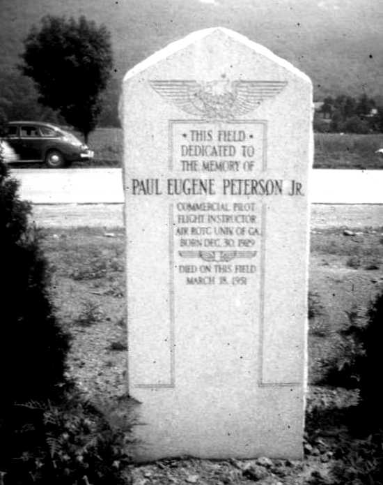
A 7/13/52 photo by Don Struke of the memorial at Peterson Field to Paul Peterson Jr.
The 1953 Cleveland Sectional Chart depicted Peterson as a commercial airport with a 2,500' unpaved runway.
The 1957 PA Aeronautical Chart (courtesy of Mike Keefe) described Peterson Memorial Field as having 3 turf runways,
with the longest being the 2,700' east/west strip.
The operator was listed as Altoona Aviation Corporation, and the manager was listed as Paul Peterson.
John Hockenbury recalled, "I had my first ride at age 6 in a Super Cruiser out of the old Tipton airport. It was a grass strip then, but pretty active."
A 5/26/58 aerial view (from Penn Pilot) showed Peterson Field to consist of an open grass area, with several hangars along the southeast side.
Peterson Field was still depicted on the 1960 Cleveland Sectional Chart (courtesy of Mike Keefe) as having a 2,500' unpaved runway.
A 1961 photo of Don Struke in front of his Piper Cub at Stultz Field.
Since I first sent the J-3 picture, I found my first log book, and its first two pages are attached in the second photo. I think the fourth instructor signature is Paul Peterson Senior's.
What's more, I ran my 1968 Corvette (an SCCA big block A Production race car) on the Peterson drag strip, probably around 1972.
Don Struke recalled of Stultz Field: “The grass strip where I learned to fly in the 1960s. It was named for Wilmer Stultz.
Not only was he the driver the first time Amelia Earhart flew the Atlantic,
but he worked in the Pennsylvania Railroad shops in Altoona.
I do not know if it was named because Stultz owned the field or to honor him,
and it runs in my mind that Paul Peterson Sr., or Old Man Peterson as we called him,
was old enough back in the 1950s & 1960s to have been a contemporary of Stultz
and may have been the one who named the airfield Stultz Field.”
Don continued, “Mr. Peterson had air shows fairly regularly
(I met my first wife there when she & a girlfriend came to a show
and I was helping to taxi Peterson's various aircraft out of the way to make more room for the crowd to park).”
Don continued, “One final approach was down across the considerable mountain east of the highway & over a small cemetery,
where a friend managed to land after forgetting to pull on carb heat & he tried to go around. Bad idea.
The strip was far from level, generally speaking,
and one nice day a USAF student on a cross-country thought he'd drop in - unofficially - to say 'hi' to his folks.
Another bad idea, because his AT-6 ended up on its back,
the neophyte aeronaut done in by the rolling nature of the terrain.
His only injury was a cut or two when he egressed (as they say) though the shattered canopy.”
Don continued, “I remember there was a Staggerwing Beech based there
and a wrecked BT-13 was perpetually parked beside one of the buildings.
My friend Roger & I were rummaging around in the loft of the hangar with no door windows
and we found some old Wilmer Stultz-era sheepskin lined leather flying suits.
We had this idea to go over to Pittsburgh Airport some rainy, foggy night
and come wandering out of the night into the terminal lights, dragging 2 opened chutes like a couple of Twilight Zone wanderers.
We never did. Today, of course, our first & only thought would be let's put that stuff on eBay.”
The 1963 AOPA Airport Directory (according to Chris Kennedy)
described Peterson Memorial as having a single 2,700' sod Runway 9/27.
Peterson Memorial Airfield evidently gained a paved runway at some point between 1960-63,
as the 1963 USGS topo map depicted the field as having a single east/west paved Runway,
with a taxiway leading to a ramp on the southeast side of the field with a few small buildings.
The 1965 Jeppesen Airway Manual (courtesy of Chris Kennedy) depicted Peterson Airfield as having a single 3,050' paved Runway 9/27,
with a taxiway leading to a ramp on the southeast side of the field with a few small buildings.
The manager was listed as Paul Peterson.
The last depiction which has been located of Peterson as an active airfield was on the May 1965 Cleveland Sectional Chart.
It depicted Peterson Memorial as having a single 3,000' paved runway.
The original Peterson Airfield was evidently closed at some point between 1965-66,
as it was depicted as an “Abandoned Airfield” on the May 1966 Cleveland Sectional Chart.
A new Peterson Memorial Airfield was constructed on the site of Tyrone Airport, just across Clearfield Avenue to the west.
Only the new Peterson Memorial Airfield was listed among active airfields in the 1967 AOPA Airport Directory (according to Chris Kennedy).
Scott Stevens recalled that the site of the original Peterson Airfield “has been the site of a PPG factory since I was a little kid, before 1965.
My father tells me this was the original Peterson field & the site where [Peterson's] son was killed.”
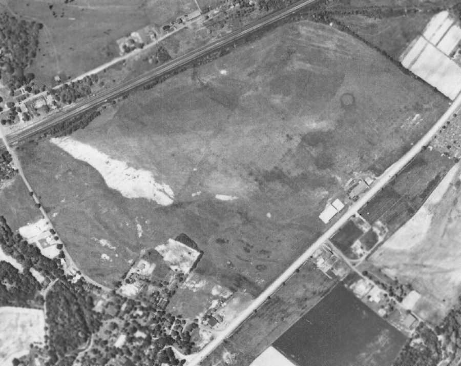
A 9/4/67 aerial view showed that the site of the original Peterson Airfield had been reused as the location of the PPG factory,
but the majority of the length of the former runway remained intact,
along with at least some of the former airport buildings (on the southeast side of the field).
A 1993 USGS aerial photo showed the outline of most of the original Peterson Airfield runway was still recognizable,
running east/west just north of the PPG plant which took over the southern portion of the airport site.
It appears as if none of the airfield buildings remained, as the factory occupied their location.
However, a memorial to Paul Peterson's son remained at the site,
just east of the dark-colored stand of trees in in between the road & the light-colored rectangle southeast of the factory.
A circa 2007 aerial view looking south at the concrete floor of the former Peterson Memorial Airport hangar.
Michael Eye reported in 2009, “I grew up across the road from the PPG building which occupies the former Stultz field site.
The original hangar floor, directly beside Route 220 was a area to play basketball provided by the PPG Corporation.
The basketball hoop is now gone but the hangar floor is still present with the notches where the doors slid.”
An August 2018 photo looking west at the memorial to Paul Peterson Jr. which has stood for 70+ years at the southeast side of the Peterson Field site.
The site of the original Peterson Memorial Airfield is located east of the intersection of Clearfield Avenue & Spruce Street.
____________________________________________________
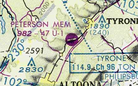
Tyrone Airport / Peterson Memorial Airfield (2nd location), Tipton, PA
40.63, -78.3 (East of Pittsburgh, PA)
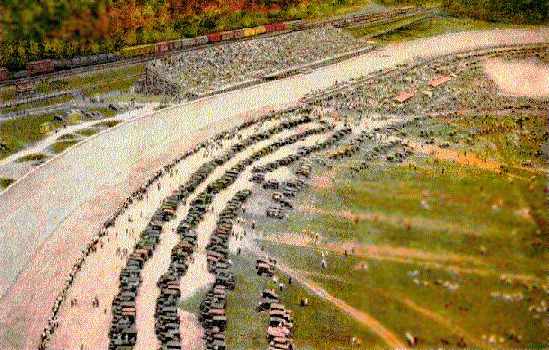
A circa 1923-29 aerial photo from a postcard depicting the Altoona Speedway.
Ironically, this property went from being an oval racetrack, to an airport, and then to a dragstrip, before finally becoming an industrial park.
This property just across Clearfield Avenue to the west from Stulz Field was the location of the Altoona Speedway starting in 1923.
The track was made of yellow pine 2x4's laid up on edge. It was 60 feet wide & 1.25 miles long.
A total of 3 racers lost their lives during the speedway's existence.
The highest speed ever recorded there was 139 mph by Leon Duray, on a test run in 1926.
The Altoona Speedway operated until it was forced to close in 1929, with the start of the Depression.
An 11/11/38 aerial view did not yet depict any recognizable aviation use of the Altoona Speedway property.
Tyrone Airport was established on the site of the abandoned speedway at some point in 1947,
as it was not yet depicted on the January 1947 Cleveland Sectional Chart.
The earliest depiction of Tyrone Airport which has been located was on the July 1947 Cleveland Sectional Chart.
It depicted Tyrone Airport as being located directly on top of an oval racetrack.
The January 1949 Cleveland Sectional Chart (courtesy of Chris Kennedy) depicted Tyrone Airport
as having a 2,300' unpaved runway (which could have fit within the center of the racetrack).
The 1953 Cleveland Sectional Chart depicted Tyrone Airport as having a 2,200' unpaved runway.
The last depiction which has been located of Tyrone Airport as an active airfield
was on the January 1955 Cleveland Sectional Chart (according to Chris Kennedy).
The Tyrone Airport was evidently closed at some point in 1955,
as it was no longer depicted at all on the December 1955 Cleveland Sectional Chart (according to Chris Kennedy).
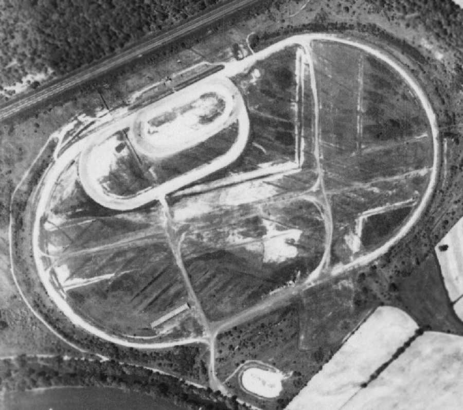
A 5/26/58 aerial view of the abandoned Tyrone Airport (from Penn Pilot)
showed the outline of 2 former grass runways along with the oval outline of the former racetrack.
Note that the north/south runway appeared to extend beyond the outline of the racetrack to the south.
It is not known if the building on the southwest corner of the site was related to the airport or the racetrack.
The 1963 USGS topo map no longer depicted the former Tyrone Airfield, just the racetrack oval.
At some point in the mid-1960s this airfield was evidently reopened as the new Peterson Memorial Airfield,
replacing the original Peterson Airfield just across Clearfield Avenue to the east.
Cathy Rodgers recalled, “I took my first plane ride (and many more) from there in my mother's cousin's husband's Piper Cub in the early 1960s.”
The earliest airport directory reference which has been located to the second location of the Peterson Memorial Airfield
was in the 1967 AOPA Airport Directory (according to Chris Kennedy).
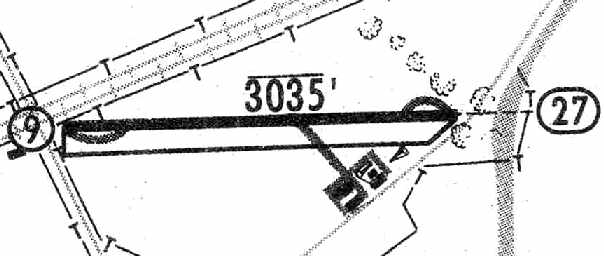
It described Peterson as having a single 5,000' bituminous Runway 8/26.
A 9/4/67 aerial view of the new Peterson Memorial Airfield
showed the facility shortly after the construction of the new paved runway,
with a hangar on the south side of the property.
Note the oval outline which remained of the 1920s-era Altoona Speedway.
The May 1968 Cleveland Sectional Chart (courtesy of Chris Kennedy)
depicted the Peterson Memorial Airport as having a single 5,000' paved runway,
right on top of the symbol for the oval racetrack.
The 1969 PA Aeronautical Chart (according to Tom Beamer)
described Peterson as having a 5,000' runway.
Erik Wagner recalled, "Peterson was an enigma to me - a 5,000' private use airport.”
Tom Beamer recalled, "I landed there in Beech E-18S N548MC on 10/7/70,
landed to the southwest & recall the runway wasn't in the best of shape in the touchdown zone
and may have had cones on potholes.
Paul Peterson was a CHARACTER. I listened to his stories for an afternoon.
He claimed to know, and/or taught to fly, many famous people.
While the details are vague now I must admit his sweeping story telling, and name dropping,
left me dazed while I attempted judge the validity & listen.
My recollection is that Goldwater, JFK, Mike Todd, etc were mentioned - it was an interesting afternoon.
[The airport's name] Memorial came from Paul's son,
[who] died from a prop strike while propping a Waco UPF-7."
Richard Finley recalled, “I met Paul Peterson in 1970. He was indeed a character.
He told me he was one of the first airline pilots. He told me about his son.
He told me how he ran the drag strip himself. He said some people took advantage of hes hearing loss.
He said 2 guys got into the back of his car when he was not looking & stole the gate receipts one day. He got a dog & cured that problem.”
Richard continued, “Yes there were cones near the east end of the runway.
Here is the story of those cones: I landed there to visit a friend who lived in Bellwood, PA in 1970.
There was a Navy S-2 Tracker parked beside the taxiway leading to the main ramp. It was listing to one side.
The next time I went in there, I mentioned it to Mr. Peterson.
He said a local man had become a Navy pilot & wanted to fly one of the squadron planes back to visit his family.
Mr. Peterson said he told the gentleman not to land at Peterson Memorial because the pavement was not built to handle the weight of an S-2.
The guy landed there anyway. On landing, they blew one of the tires.
Mr. Peterson told them not to bring the parts and repair crew in on another S-2 but they did anyway.
Peterson told them to fix their airplane then get out & don"t come back.
They fixed the flat & the first plane departed.
When the second tried to spin around in position at the end of the runway, his right main broke through the pavement and sunk into the earth below.
They had to jack it up to get it out of there.
OK, now he has a damaged runway. How do you fix it?
Mr. Peterson painted a displaced threshold on the runway.
He put up some cones & stuck a short pole with a flag on it in the hole.
He then contacted Coast & Geodetic Survey & had them shorten his runway by 200 feet on the maps.”
Richard continued, “I landed there in my Cessna 150. I asked that the airplane be serviced while I was gone.
I pointed out to the kid working the line that one of the Dzus fasteners on my oil/engine access door was missing
and had been replaced temporarily by a slotted Dzus fastener with no retainer.
I warned him to be sure that one was properly seated.
My wife & I spent the day visiting & planned to depart after dark.
That was somewhat problematic since Peterson Memorial was not lighted.
I did a quick preflight & bid Mr. Peterson a good evening. We departed from the dark runway with no problem.
Upon takeoff, we encountered a problem less than a mile from the field.
There was a snap sound followed by a very loud 'ratta-ratta-ratta' sound that would rise, ebb then rise again.
This process kept repeating itself.
I could not see in the dark what was happening but I suspected that fastener on the engine access door may have something to do with it.”
Richard continued, “Peterson Memorial was unlighted. It was located in the floor of a deep valley.
There was a large water tower very close to centerline about a quarter mile from the approach end of the runway.
There were obstacles on the pavement at the approach end of the runway.
Making an night approach/landing into an airport like that is not a safe thing to do.
Flying around with an airplane that sounded like it was beating itself to death
and not knowing for sure what the problem was was not very safe either.
I decided to try a landing.
On the downwind to the west runway, there was an obstruction light at the top of the mountain where a road crested the hill.
It was a good place to turn base. I flew toward that obstruction light but kept it off my right.
I began my descent when I was abreast of the obstruction light
and descended so as to pass the water tower at an altitude slightly above the water tower and with the tower just off my right.
I turned on my landing light & soon had the end of the runway in sight.
I made sure I crossed the threshold a little high so there would be no problem with the obstacles.”
Richard continued, “My landing was successful & Mr. Peterson was still there.
I went in to complain about what his lineman had done. He & I went out into his hangar.
He emptied out a coffee can full of junk/spare hardware. We found a Dzus fastener like the one I had been using.
Mr. Peterson never apologized for what his employee had done & he charged me fifty cents for the fastener.
I never met him again after that. He was a man with many rough characteristics.
He was still one of those people I will never forget & I am glad I had the opportunity to engage with him.”
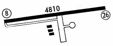
The 1971 Flight Guide (courtesy of Chris Kennedy) depicted Peterson Memorial as having a single 4,810' paved Runway 8/26,
with a taxiway leading to a ramp on the south side of the field, with 3 buildings.
The field was also described as conducting drag racing.
Don Struke recalled, “I ran my 1968 Corvette (an SCCA big block A Production race car) on the Peterson drag strip, probably around 1972.”
According to Tom Beamer, the 1974 PA Aeronautical Chart depicted it as P.E. Peterson Memorial.
Peterson Memorial Field was described by the 1975 SkyCharts Enroute Atlas (according to Timothy Aanerud)
as having a single 4,800' hard-surface runway 8/26.
It indicated that the field was attended until dusk,
but that drag racing was conducted on Sundays.
Jim Hackman recalled, “In mid 1975-76, we landed at Peterson Field in a Citation 500.
Probably the only jet to land there & there was no one around to witness.
Back in 1973-74 we landed at a lot of places that had never hosted a jet!
We landed there because that's where the Traffic Department scheduled us.
It was a nice morning & the copilot made a good landing.
Just as he shoved the [thrust] reversers we went past a sign along the side of the runway.
It said 'No aircraft beyond this point'.
We turned around on the drag strip portion & taxied in.
There was nobody there; it was deserted. We called over to Altoona Blair County [Airport] & located our passengers.
'Didn't they tell you Peterson Field? Yes but we knew you couldn't land a jet there!'
My comeback: 'Where do you think I'm calling from?'
We jumped over to pick them up & flew the trip.”
The last chart depiction which has been located of Peterson Memorial as an active airfield
was on the December 1976 CF-18 World Aeronautical Chart (courtesy of Chris Kennedy).
It depicted Peterson as having a single 4,700' paved runway.
Peterson Memorial Airfield may have been closed at some point in 1976,
as is was not depicted at all on the 1976 PA Aeronautical Chart (according to Tom Beamer).
Scott Stevens recalled, “I grew up in the nearby community of Tyrone.
I spent many nights creeping into the site back in the mid 1980s.
There was indeed drag racing that went on after the field closed.
In fact on one of my trips I discovered a small building with the remnants of 2 turnstiles
that may have been used to charge admission to the races.
There were also the remains of some wooden bleachers.
I was told by my family that before it was an airstrip it was a dirt banked race track.
The tale told in my family is this was how my grandfather squandered the family fortune
as the race track was his & he opened it during the depression.
I never noticed the remnants of the racetrack when I was a teen
but then at 1.5 miles in diameter it would be hard to see at ground level.”
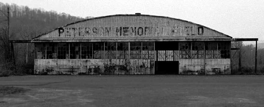
A 1985 photo by Scott Stevens of the main hangar, with the lettering still clearly reading “Peterson Memorial Airfield”.
Scott recalled, “The hangar was still intact although the doors were rusted in place.”
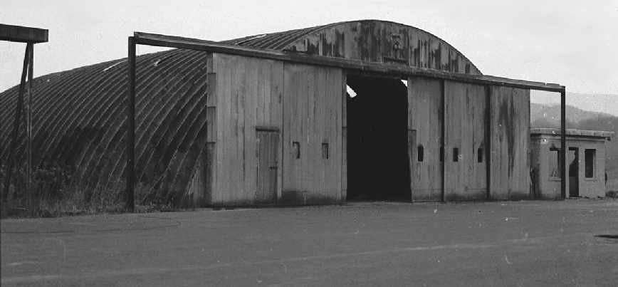
A 1985 photo by Scott Stevens of the smaller hangar at Peterson, which was “full of old tires (auto not aircraft).”
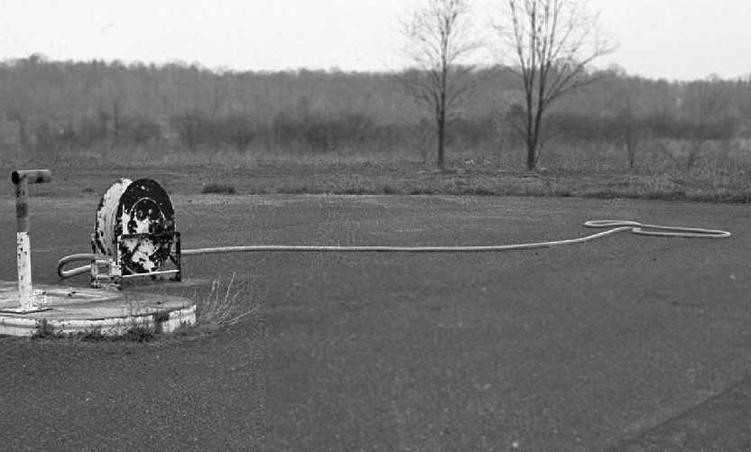
A 1985 photo by Scott Stevens “of one of the fuel lines still attached to the take-up wheel & just kind laying on the ground,
almost as if waiting for a Cessna or Beech to come rolling over to be refueled.”
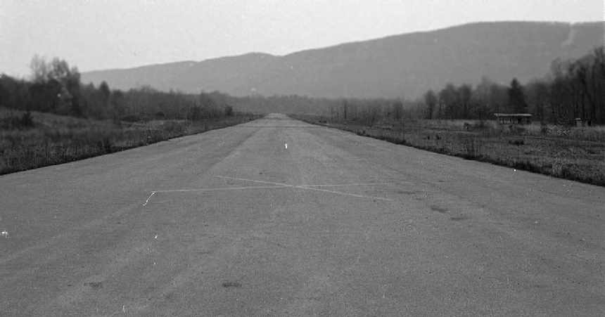
A 1985 photo by Scott Stevens looking along Peterson's abandoned Runway 26,
with “the large X painted on the runway right in front of my all-seeing teenage eyes.
But as narrow & faded as it looks I would imagine hat would be hard to see from any great distance.
The northern end was usually flooded due to a beaver dam between the airport & the railroad tracks.
To the right of the runway are 2 buildings.
On close examination one appeared to be some sort of concession stand & the other a bathroom.
The building with the turnstiles was even farther to the right, in the overgrown section amongst the trees.”
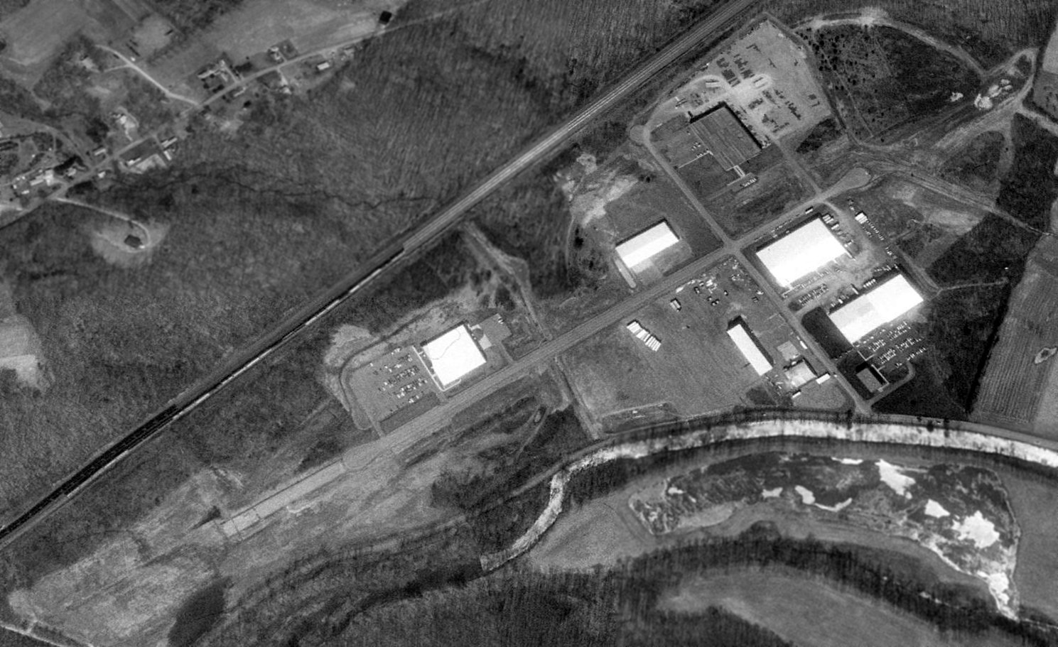
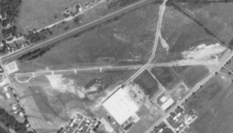
In a 1993 USGS aerial view looking northeast, most of the former Peterson Memorial Airfield runway still existed, having been reused as a street, Park Avenue.
Several buildings had been constructed on either side of the former runway.
A new road, Holiday Parkway, had been built crossing over the center of the former runway.
It appeared as if the former main hangar still remained standing (just west of Holiday Parkway on the southern edge of the field),
while the smaller hangar appears to have already been removed (there is a rectangular patch of ground at its location,
but the building appears to have been removed).
Amazingly, most of the oval outline of the racetrack which predated the airfield was also still recognizable, on the eastern side of the site.
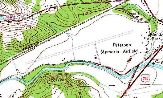
USGS topo map 1995.
A 2003 aerial view by Paul Freeman looking southwest at the runway of the former Peterson Airfield.
The entire length of the runway still existed & was quite recognizable from the air,
complete with circular turn-around pads at both ends of the former runway.
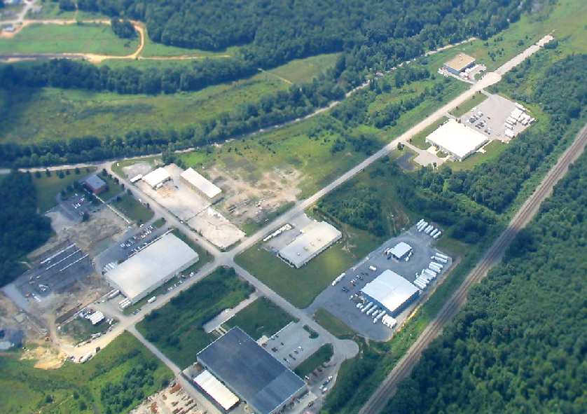
A recent (2000-2005?) aerial view looking southeast at the former Peterson Airfield.
It appeared as if the former main hangar still remained standing (at the top-center of the photo).
As of 2005, the site of Peterson Airfield was known as the Ardie J. Dillen Industrial Park,
and it was being offered for sale by the Altoona Blair Development Corporation.
A circa 2007 aerial view looking west at the former hangar which remains standing at the site of the 2nd Peterson Memorial Airport.
A circa 2007 aerial view looking east at the end of the former runway at the site of the 2nd Peterson Memorial Airport.
A 2015 aerial view looking northeast showed most of the former Peterson Memorial Airfield runway still existed, along with the hangar.
Only faint traces of the oval outline of the racetrack which predated the airfield was still recognizable (top-right).
The site of the second location of Peterson Memorial Airfield is located north of the intersection of River Road & Holiday Parkway.
____________________________________________________
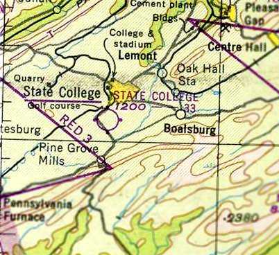
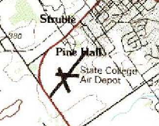
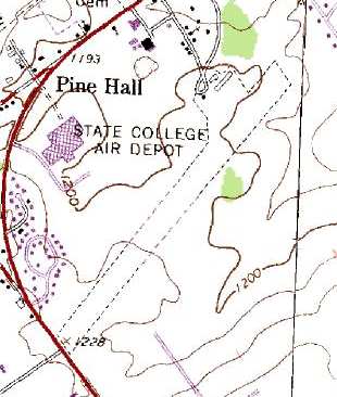
State College Air Depot (1st location), Boalsburg, PA
40.79, -77.79 (Northwest of Harrisburg, PA)
State College Air Depot, as depicted on the January 1934 NY Sectional Chart.
The date of construction of the State College Air Depot has not been determined.
It may have been established at some point between 1933-34,
as it was not yet depicted on the August 1932 NY Sectional Chart, and no airfield was listed at this location was listed in The Airport Directory Company's 1933 Airport Directory (according to Chris Kennedy).
The earliest depiction which has been located of the State College Air Depot was on the January 1934 NY Sectional Chart.
It depicted State College as a commercial/municipal airfield.
The 9/1/34 Commerce Department Airport Directory (according to Chris Kennedy)
described the State College Air Depot as having 2 sod runways in a "T" shape, with the longest being a 2,100' east/west strip.
The earliest photo which has been located of the State College Air Depot
was an undated aerial view in The Airport Directory Company's 1937 Airport Directory (courtesy of Bob Rambo).
It described State College as a commercial airfield, consisting of a 45 acre property having 3 sod runways, with the longest being the 2,200' north/south strip.
A single hangar was pictured on the west side of the field.
According to Rodney Hersh, his father “learned to fly from Sherm Lutz... in the 1930s at the old Boalsburg location.”
A 1938 aerial view depicted the State College Air Depot as having a grass airfield area with a circular airport marking in the center.
A second building had been added at some point on the west side of the field,
but it is not evident that this building was related to the airport.
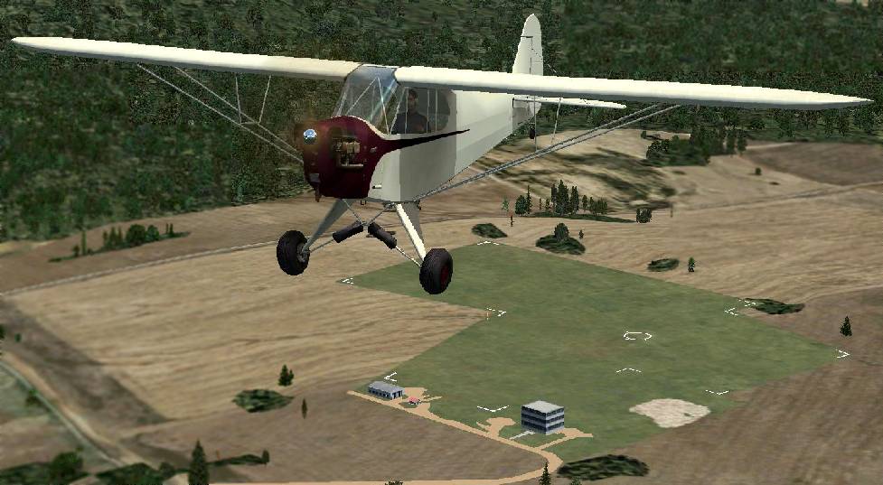
A Flight Simulator scenery recreation by Richard Finley of a Piper Cub overflying original State College Air Depot.
Jim McCoy reported his father took flight training with Sherm Lutz in 1939-40 at the Bloalsburg airfield location.
The 1944 US Army/Navy Directory of Airfields (courtesy of Ken Mercer) described the Air Depot as having a 1,900' runway.
The 1945 AAF Airfield Directory (courtesy of Scott Murdock) described State College Air Depot
as a 42 acre irregularly-shaped property within which were 2 sod runways, measuring 1,850' east/west & 1,700' north/south.
The field was said to have a single 46' x 36' wooden hangar,
and to be owned by private interests, and operated by State College Air Depot, Inc.
The last aeronautical chart depiction which has been located of the original State College Air Depot
was on the November 1945 NY Sectional Chart (courtesy of Chris Kennedy).
It depicted State College as a commercial/municipal airfield.
A new State College Air Depot had evidently been established on the southwest side of the town at some point between 1945-46,
as Sherm Lutz moved his flying service to the new airfield in 1946.
The original State College Air Depot was closed by 1949,
as only the new airfield (on the southwest side of State College) was depicted on the January 1949 NY Sectional Chart (courtesy of Chris Kennedy).
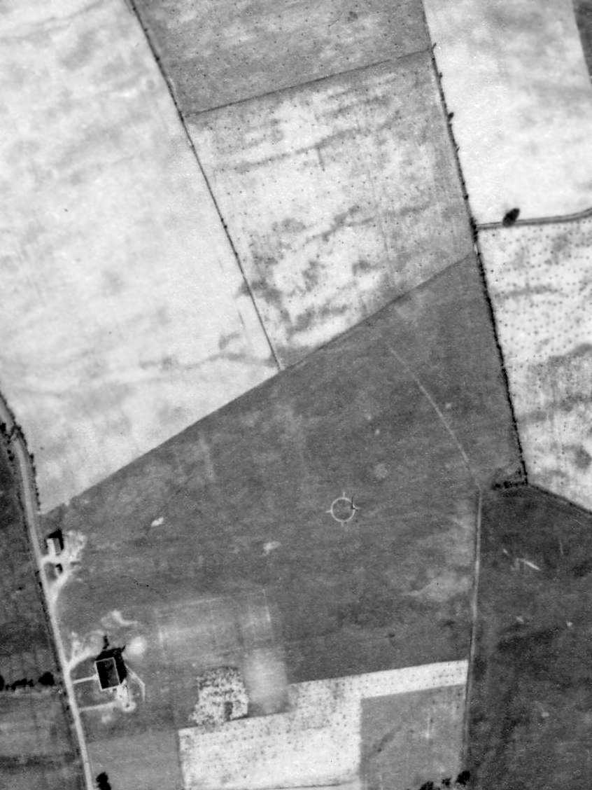
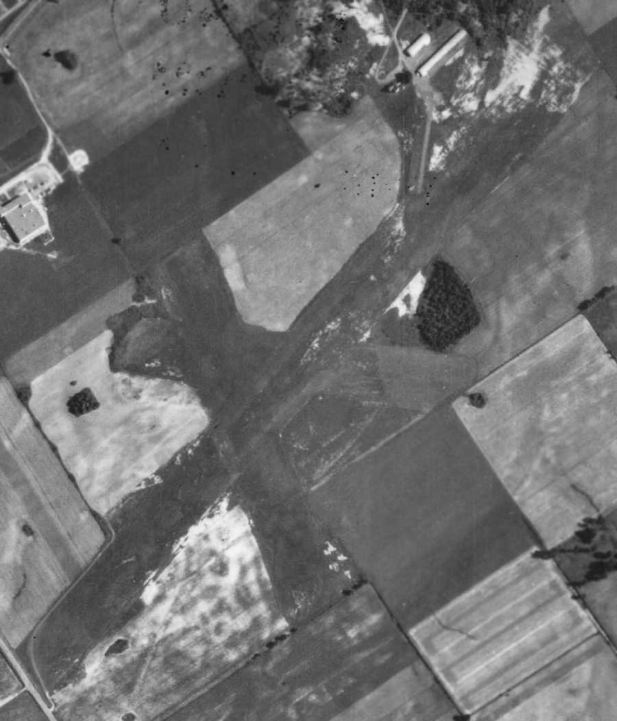
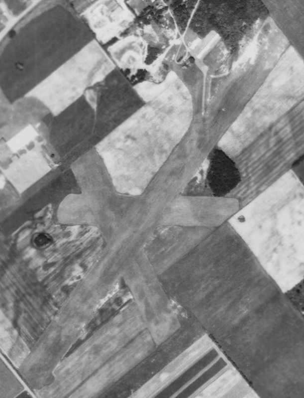
A 1957 aerial view showed the hangars remained on the west side of the site of the original State College Air Depot,
but the airfield had been reused for farming.
The original State College Air Depot was no longer depicted at all on the 1957 or 1962 USGS topo maps.
A 1971 aerial view showed that the new 4-lane Route 322 had been built through the center of the Air Depot property,
with houses having been built along the southwest.
Amazingly, the larger hangar seen at the southwest corner of the airfield in the 1938 aerial photo remained standing, with houses surrounding it.
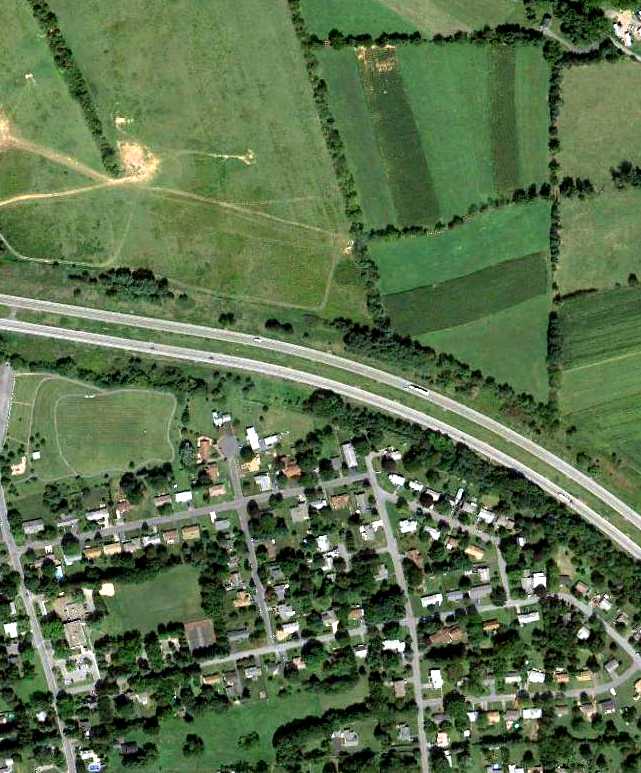
An 8/31/12 aerial view showed Route 322 & houses covering the majority of the site of the original State College Air Depot.
However, a comparison of aerial photos shows that St. Joseph's Academy occupies the same building (perhaps heavily rebuilt)
which was seen as a hangar at the southwest corner of the airfield in the 1938 aerial photo.
The site of the original location of State College Air Depot is located northeast of the intersection of Boalsburg Pike & Belle Avenue.
____________________________________________________
State College Air Depot (2nd location) (SCE), State College, PA
40.772, -77.881 (Northwest of Harrisburg, PA)
State College Air Deport, as depicted on the January 1949 NY Sectional Chart (courtesy of Chris Kennedy).
The original location of the State College Air Depot (southeast of the town) was replaced by a new location on the southwest side of the town.
According to Rod Hersh, “The field opened in 1946.”
Sherm Lutz moved his flying service from the earliest location of the State College Air Depot
to the new State College Air Depot (on the west side of town) in 1946.
He operated a charter service, gave flying lessons,
and cooperated with Penn State's aeronautical engineering & civilian pilot training programs.
However, the 2nd location of State College Air Depot was not yet depicted on the July 1947 Cleveland Sectional Chart.
The earliest depiction which has been located of the new airfield was on the January 1949 NY Sectional Chart (courtesy of Chris Kennedy).
It depicted the new State College Air Depot as having a 3,300' unpaved runway.
Local government leaders considered acquiring the facility & putting in a hard surface runway,
and All American Airlines began scheduled flights in 1949 with the legendary DC-3s.
This was the first commercial air transport in Centre County, ushering in a new era of transportation,
overcoming for the first time the mountain barriers which had formerly rendered the region difficult to access.
Karl Striedieck recalled, “I did a lot of flying at the second State College Air Depot.”
The 1950 NY Sectional Chart (courtesy of Mike Keefe) depicted State College Air Depot as having a 4,300' unpaved runway.
The Borough eventually decided against buying or improving the Air Depot, however,
and All American (soon to be Allegheny Airlines) ended service in 1951.
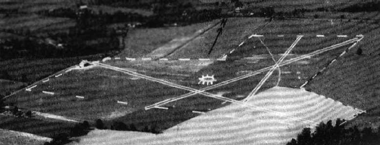
The earliest photo which has been located of the 2nd location of the State College Air Depot was a 7/2/57 aerial view of the (from Penn Pilot).
It showed the field to consist of 3 grass runways with 2 rows of hangars at the north end.
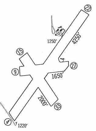
The 1960 Jeppesen Airway Manual (courtesy of Chris Kennedy) depicted the State College Air Depot as having 3 unpaved runways,
with the longest being the 4,250' Runway 4/22.
A small ramp on the north side of the field had several small buildings (hangars?).
The 1962 AOPA Airport Directory described State College Air Depot
as having 3 turf runways: 4,250' Runway 4/22, 2,000' Runway 15/33, and 1,600' Runway 9/27.
The operator was listed as State College Air Depot, Inc.
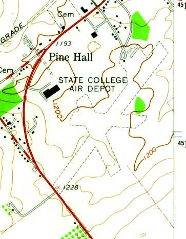
The earliest topo map depiction which has been located of the State College Air Depot was on the 1962 USGS topo map.
It depicted State College as having 3 unpaved runways, with several small buildings on the north side.
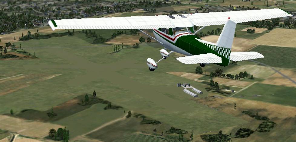
A Flight Simulator scenery recreation by Richard Finley of a Cessna 152 overflying State College Air Depot.
The 1967 NY Sectional Chart (courtesy of Mike Keefe) depicted State College Air Deport as having a 4,200' unpaved runway.
A circa 1970 aerial view looking north at State College Air Deport (courtesy of Rod Hersh)
depicted the field as having 3 grass runways, with a few small buildings on the northwest side of the field.
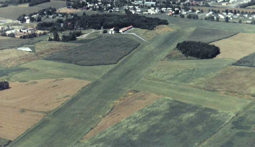
A 7/3/1971 aerial view of State College Air Depot depicted the 3 grass runways, and the cluster of hangars at the north end of the field.
According to Rodney Hersh, “I learned to fly from Sherm Lutz in the early 1970s.
Sherm was like another member of our family when I was a kid in State College.”
Alan Uhler recalled, “My father's airplane, a 1947 Stinson 108-3 was based at Sherm Lutz's airport in 1980-81.
It was an interesting airport, complete with Sherm's warnings
to be careful not to use the extreme westward end of the remaining runway as it still had ruts in it from the DC-3s.
As a 10 year old, his airport was a really neat place to be.
For my father who had just finished a two & a half year restoration of what is now my Stinson,
it was a frustrating airport as he could not get the hangar doors open between late November & sometime in March, [due to] frost heaving.
The hangar we were in had no floor & when the ground froze, the ground heaved up against the bottom of the door locking it in place.”
The last aeronautical chart depiction which has been located of State College Air Depot was on the May 1981 Detroit Sectional Chart (courtesy of Ron Plante).
It depicted State College Air as having a 4,100' unpaved runway.
By the time of the 1982 AOPA Airport Directory (courtesy of Ed Drury),
apparently the 2 shorter strips had been abandoned, as the 4,350' turf Runway 4/22 was the sole runway listed.
Joe Rossi recalled of State College Air Depot, “Back in the early 1980s I used to fly singles to a small airfield in downtown State College. It was a grass strip & unattended.
I could land then walk into downtown in 5 minutes.”
The 1985 USGS topo map still depicted State College Air Depot as having 3 runways.
The 1986 Flight Guide (according to Chris Kennedy) described State College Air Depot as having a single 4,065' turf Runway 4/22.
The 1987 USGS topo map depicted State College Air Depot as having a single unpaved runways, with several buildings on the north side of the field.
According to Erik Wagner, "I think I still have an approach plate for State College.
It had an instrument approach into the grass runway until the 1980s when it closed."
According to Rod Hersh, “The field closed in 1987, largely because of Sherm's advancing age. He sold the property.”
In the 1994 USGS aerial photo, the outline of the former State College Air Depot Runway 4/22 was still apparent,
although homes had been built over the 2 ends of the former runway.
Two former hangars still remained standing, the long, narrow white buildings just east of the former airport entrance road at the north end of the photo.
A 2004 aerial photo showed the 2 former hangars on the north end of the State College Air Depot site had been removed at some point between 1994-2004,
erasing the last trace of the little airport.
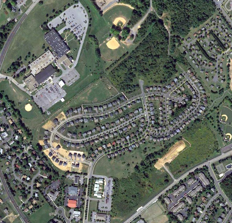
A 2015 aerial photo showed a housing development had covered the site of State College Air Depot.
The site of the 2nd State College Air Depot is located south of the intersection of Route 26 & Airport Road.
See also:
http://centrecountyhistory.org/cc_overview4.html
http://www.libraries.psu.edu/crsweb/speccol/pshistory/083sv176.htm
____________________________________________________
Since this site was first put on the web in 1999, its popularity has grown tremendously.
If the total quantity of material on this site is to continue to grow,
it will require ever-increasing funding to pay its expenses.
Therefore, I request financial contributions from site visitors,
to help defray the increasing costs of the site
and ensure that it continues to be available & to grow.
What would you pay for a good aviation magazine, or a good aviation book?
Please consider a donation of an equivalent amount, at the least.
This site is not supported by commercial advertising –
it is purely supported by donations.
If you enjoy the site, and would like to make a financial contribution,
you
may use a credit card via
![]() :
:
Please consider checking the box to make a monthly donatation.
For a mailing address to send a check, please contact me at: paulandterryfreeman@gmail.com
If you enjoy this web site, please support it with a financial contribution.
please contact me at: paulandterryfreeman@gmail.com
If you enjoy this web site, please support it with a financial contribution.
____________________________________________________
This site covers airfields in all 50 states.