Abandoned & Little-Known Airfields:
Pennsylvania: Lancaster Area
© 2002, © 2023 by Paul Freeman. Revised 6/26/23.
This site covers airfields in all 50 states: Click here for the site's main menu.
____________________________________________________
Please consider a financial contribution to support the continued growth & operation of this site.
Downingtown Airport / Shannon Airport (revised 6/26/23) - (Original) Lancaster Airport (revised 9/3/22)
McGinness Airport (revised 9/3/22) - New London Airport (revised 2/17/21) - Oxford Airport (revised 11/20/22) - Stoltzfus Field (revised 5/13/21)
____________________________________________________
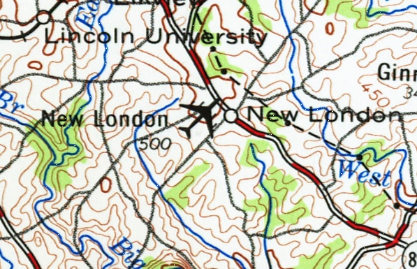
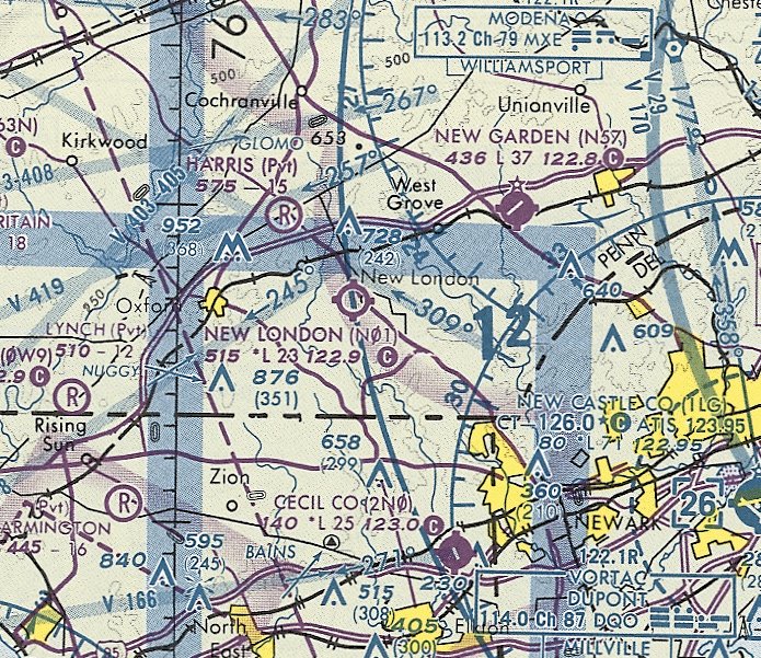
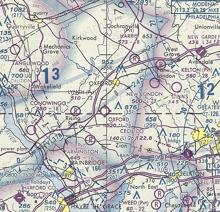
New London Airport, New London, PA
39.782, -75.879 (South of Lancaster, PA)
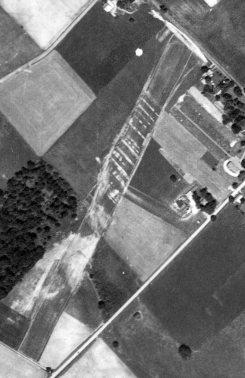
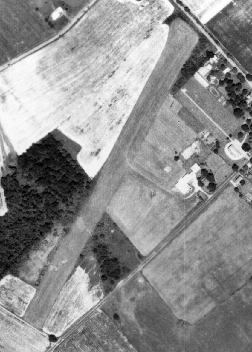
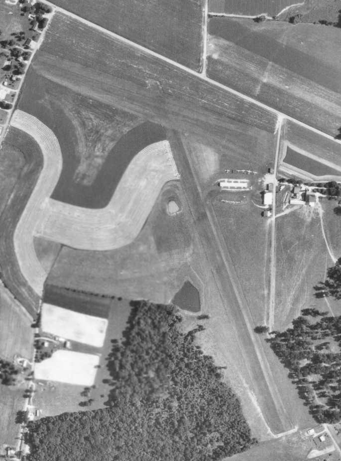
New London Airport, as depicted on a 6/14/58 aerial view (from Penn Pilot).
This small general aviation airport was evidently established at some point between 1958-58,
as it was not yet depicted on a 1950 aerial photo or on the March 1958 Washington Sectional Chart.
The earliest depiction which has been located of New London Airport was a 6/14/58 aerial photo (from Penn Pilot).
It depicted New London Airport as having a grass northeast/southwest runway.
Two or possibly 3 light single-engine aircraft were visible around some small buildings on the east side.
The earliest aeronautical chart depiction which has been located of New London Airport was on the September 1958 Washington Sectional Chart.
It depicted New London Airport as having a 2,500' unpaved runway.
The July 1961 Philadelphia Local Aeronautical Chart (courtesy of Tim Zukas)
depicted New London Airport as having a 2,500' unpaved runway.
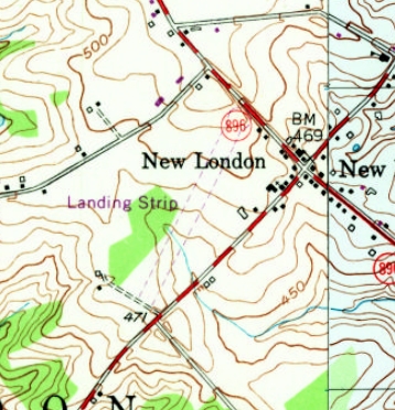
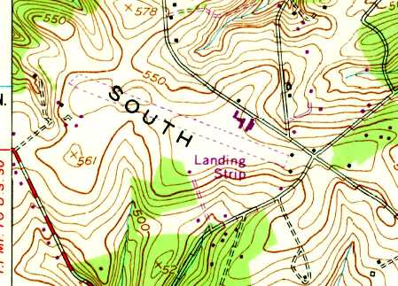
The earliest topo map depiction which has been located of New London Airport was on the 1968 USGS topo map.
It depicted a single unpaved northeast/southwest runway, labeled simply as “Landing Strip”.
A 7/5/71 aerial view (from Penn Pilot) depicted New London Airport in an unchanged manner. There were no aircraft visible on the field.
Ironically the 1972 USGS topo map depicted New London Airport with a 4-engine swept-wing aircraft symbol -
a little generous for an airfield with a 2,500' grass runway.
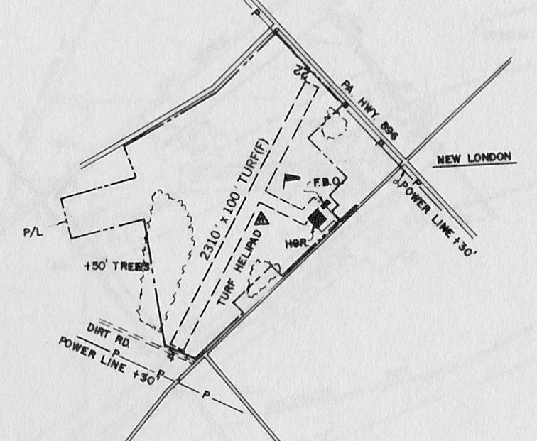
The 1983 PA Airport Directory depicted New London Airport as having a 2,310' turf Runway 4/22,
with a turf helipad, hangar, and FBO on the east side.
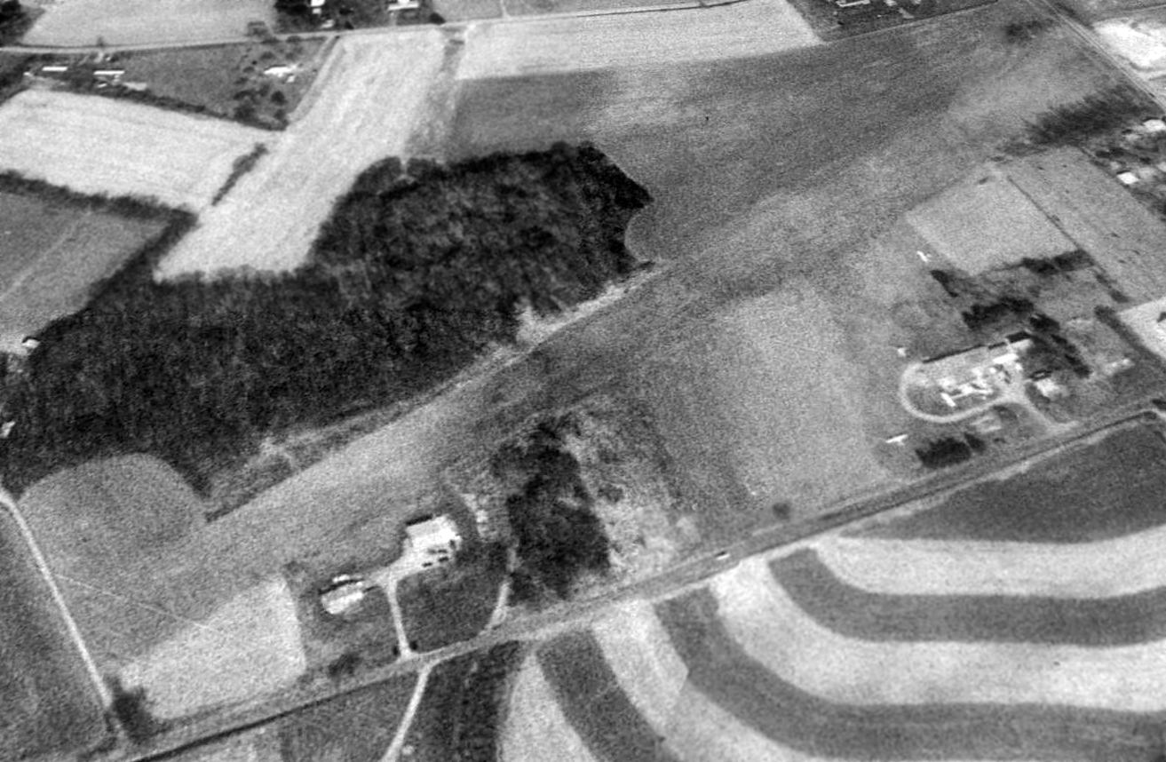
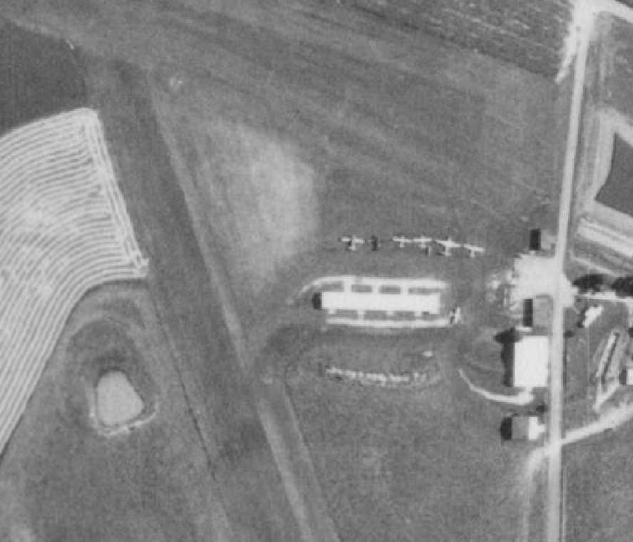
The last photo which has been located showing aircraft at New London Airport was a 1992 aerial view looking northwest.
Three light single-engine aircraft were visible on the east side of the field.
The last aeronautical chart depiction which has been located of New London Airport was on the March 1994 Washington Sectional Chart (courtesy of Ron Plante).
It depicted New London Airport as having a 2,300' unpaved runway.
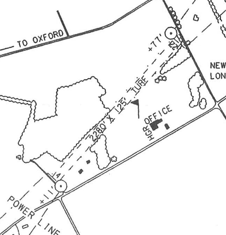
The 1997 PA Airport Directory (courtesy of John Clifford) depicted New London Airport as having a 2,280' turf Runway 4/22,
with an office & hangar on the east side.
It listed the manager as Joseph Bohmier, and the Fixed Base Operator as Spitfire Helicopter.
New London Airport was no longer depicted on the 2002 Washington Sectional Chart (courtesy of Jonathan Westerling).
A 2002 aerial photo still showed the New London Airport runway as distinct, but there were no aircraft visible on the property.
A 2005 aerial photo showed that the area of the runway remained clear, but was no longer distinctly outlined.
Presumably this may have been the point at which the operation of the airport had ceased.
According to the New Garden Airport website, “The New London Airport was lost due to to loss of the son who had the most interest in continuing the operation of the airport.”
A 2008 aerial view showed that a large church building had been constructed over a portion of the north end of the former New London Airport runway.
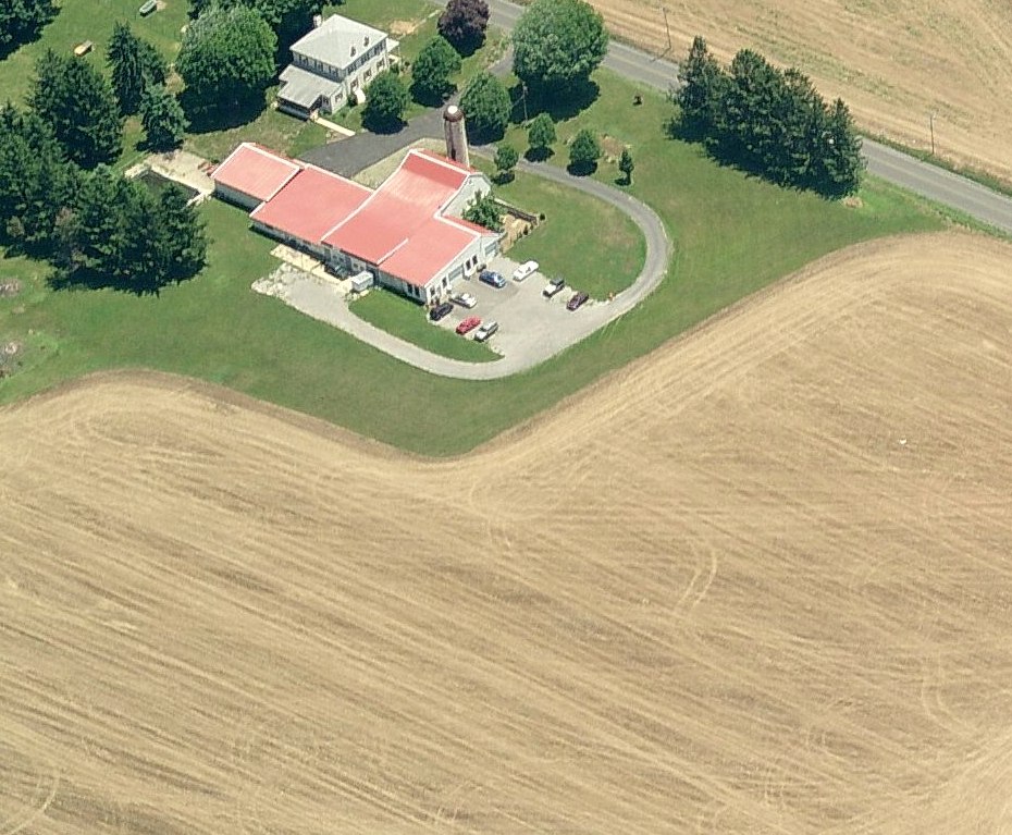
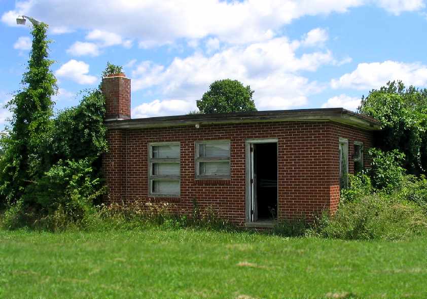
A circa 2010 aerial view looking east at the former New London Airport building on the east side of the former runway.
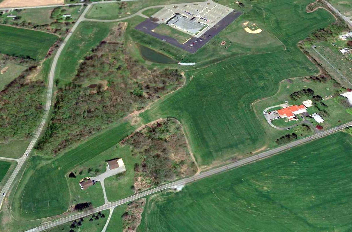
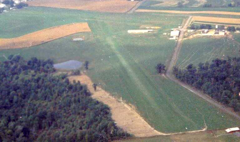
A 2013 aerial view looking northwest showed that a majority of the former New London Airport runway remained clear,
and the airport building on the east side remained standing.
The site of New London Airport is located west of the intersection of State Road & Newark Road.
Thanks to Joanne Grossman for pointing out this airfield.
____________________________________________________
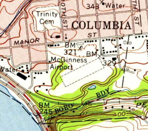
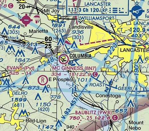
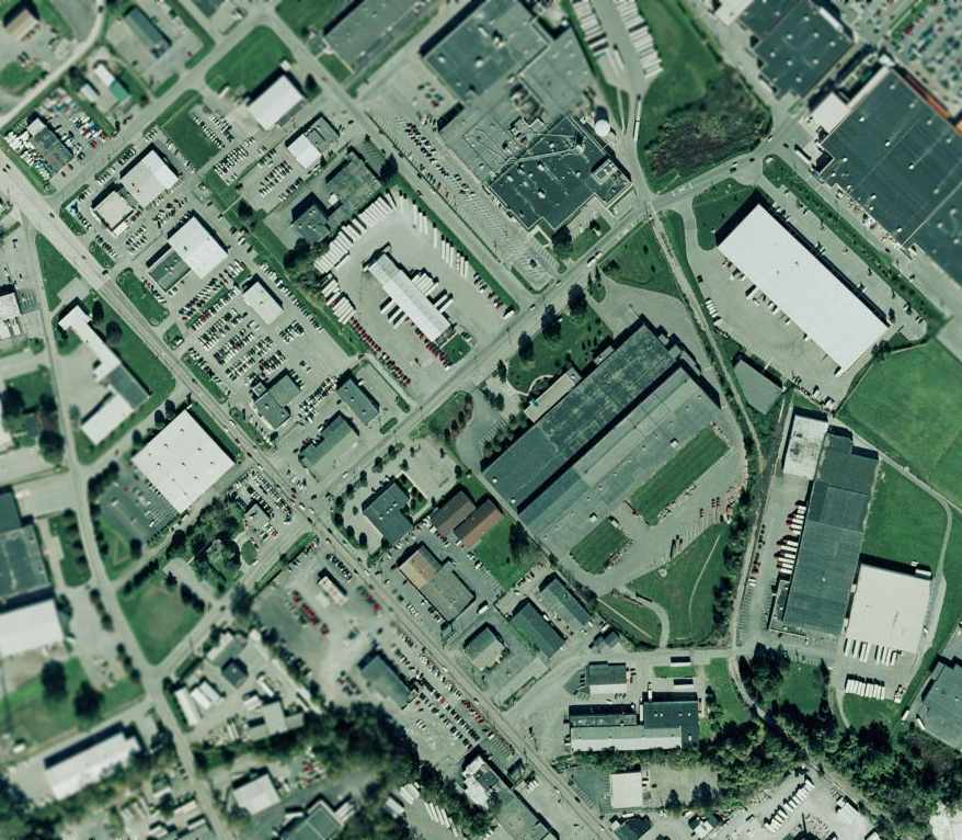
McGinness Airport (8N7), Columbia, PA
40.024, -76.488 (West of Lancaster, PA)
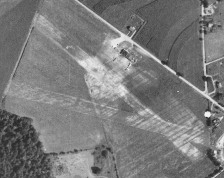
A 4/21/51 USGS aerial view depicted McGinness Airport as having 2 unpaved runways.
According to its FAA Airport/Facility Directory data, McGinness Airport was established in December 1949.
According to his obituary, George McGinness “was known for having built, owned & operated the McGinness Airport where he taught flight instruction.”
The earliest depiction which has been located of McGinness Airport was a 4/21/51 USGS aerial view.
It depicted McGinness as having a 2 unpaved runways, with 2 Quonset huts along the north side.
There were no aircraft visible on the field.
McGinness Airport was not yet depicted on the January 1953 NY Sectional Chart.
The earliest aeronautical chart depiction which has been located of McGinness Airport was on the July 1953 NY Sectional Chart.
It depicted McGuiness Airport as having an 1,900' unpaved runway.
The earliest topo map depiction of McGinness Airport which has been located was on the 1956 USGS topo map.
It depicted McGuiness Airport as having 1 unpaved northeast/southwest runway.
Brian Gledhill recalled, “McGinniss Aerodome... I was exploring the Aerodome with my father and saw, in one of the Quonset Hut hangars on the property,
a navy blue F-80 fighter, with insignia painted out, and with the gun openings stuffed with red rubber balls.
We were told that the jet was being secretly prepared for use against Castro in Cuba, several months prior to Bay of Pigs [1961].
We actually thought the plane was going to be trucked out, and had been trucked in as well.”
The 1968 USGS topo map continued to depict McGinness Airport in an unchanged fashion.
The 1971 USGS topo map showed that McGinness Airport had gained a crosswind runway, oriented northwest/southeast.
The 2 Quonset huts on the north side of McGinness Airport remained standing in a 1992 aerial view.
The 1997 PA Airport Directory (courtesy of John Clifford) depicted McGinness Airport as having 2 unpaved runways, with the longest being the 1,850' northwest/southeast strip.
It listed the manager as George McGinness.
The 2 Quonset huts on the north side of McGinness Airport appear to have been removed by the time of a 1999 USGS aerial view,
perhaps indicative of the little airport's waning use.
A 2004 aerial view showed the runways were still intact.
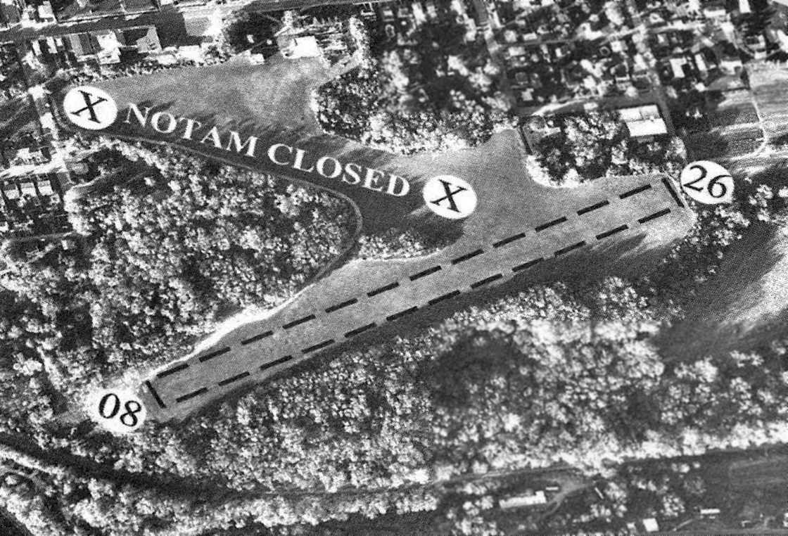
An undated aerial view from the 2005 PA Airport Directory (courtesy of John Clifford) showed that McGinness Airport's northwest/southeast runway had been closed via NOTAM,
but Runway 8/26 was still shown as operational. It listed the manager as George McGinness.
A 2005 aerial view showed that a closed-runway “X” symbol had been added over the center of the airfield.
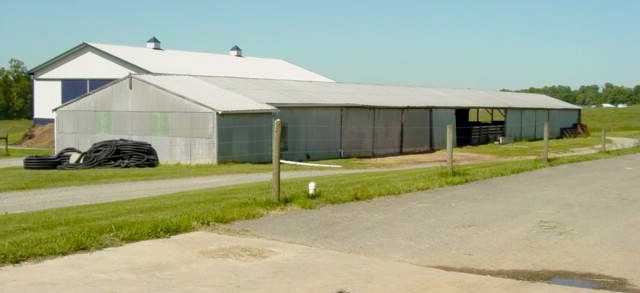
John Clifford recalled, “McGinness Airport... I landed there once [circa 2008-2009].
It was a short turf strip that sat up on a knoll, and the ground dropped off rapidly on either end of the runway.
Sort of like you’d imagine it would be like if you were landing on an aircraft carrier.
The plus side of that was the neighboring houses & buildings all sort of sat below the runway,
so there wasn’t a whole lot in the way of actual obstructions (even though it looked like there was from the air).
I don’t remember seeing any other aircraft the day I flew in, but the runway was well maintained & smooth for a turf surface.”
McGinness Airport founder George McGinness passed away in 2011.
A circa 2011 aerial view looking north depicted the closed-runway “X” symbol on the McGinness runway,
and the house built over the site of the former airport Quonset huts.
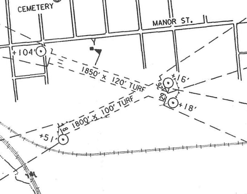
As of 2013, McGinness Airport's FAA Airport/Facility Directory data described the field as having 2 turf runways, in good condition:
1,850' Runway 11/29 & 1,800' Runway 8/26.
It was said to be owned by Dorothy McGinness, with the manager listed as Patrick McGinness.
The airport was said to conduct an average of 23 takeoffs or landings / month.
A 4/24/13 aerial view showed McGinness Airport as remaining intact, but with 2 closed-runway “X” symbols on the northwest/southeast runway.
The last aeronautical chart depiction of McGinness Airport was on the 2014 NY Sectional Chart,
which depicted it as a public-use airport having an 1,800' unpaved runway.
Unfortunately the end came for this nice little unpaved public-use airport on 3/13/14, when a NOTAM was issued permanently closing the airport.
It was a rare remaining example in this modern age of a public-use grass runway airport, particularly in such a populated area.
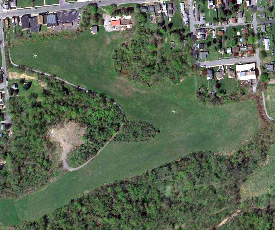
A 5/11/14 aerial view by Paul Freeman looking northwest at McGinness Airport,
showing it remaining intact, but with 2 closed-runway “X” symbols on the northwest/southeast runway.
McGinness Airport was no longer depicted on the July 2016 NY Sectional Chart.
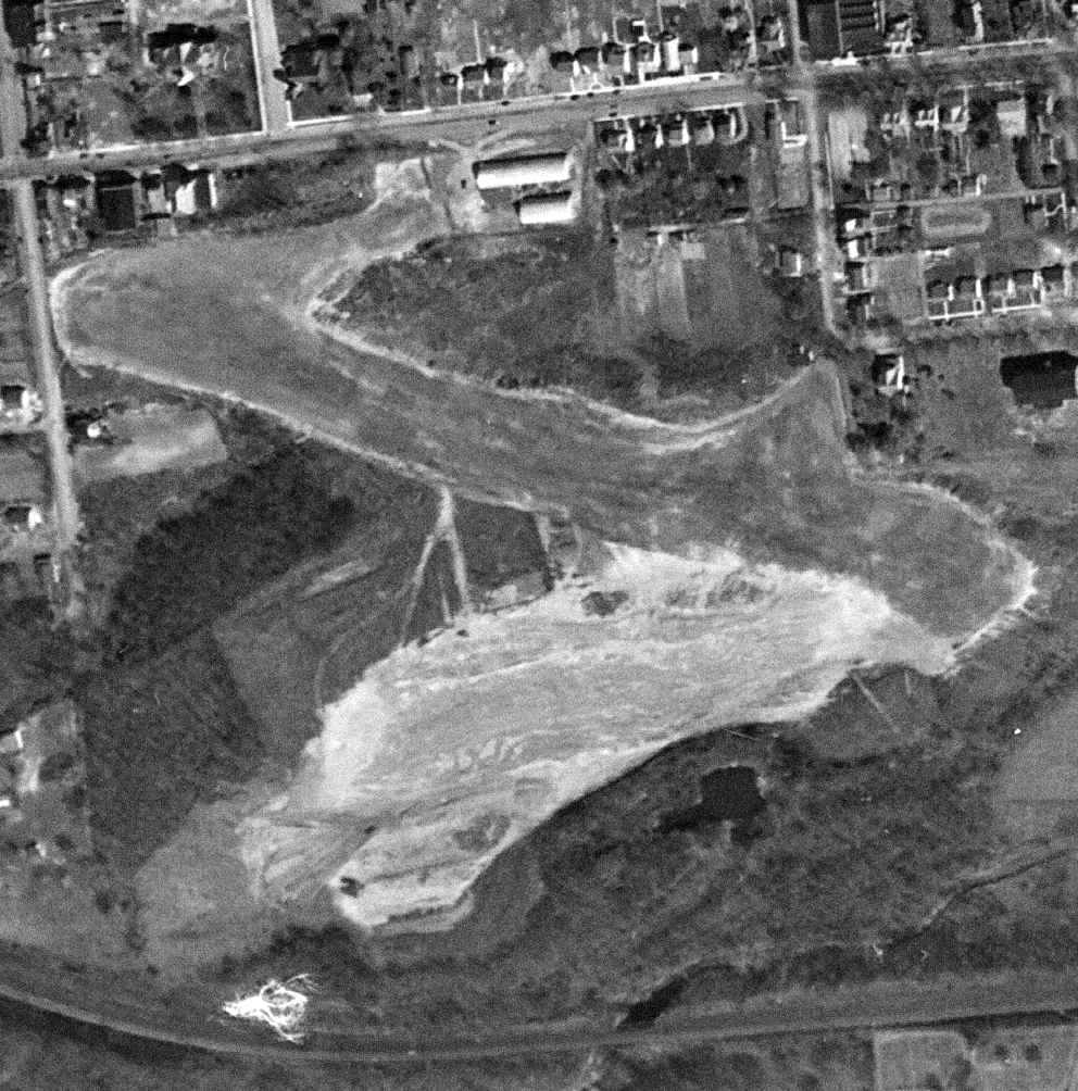
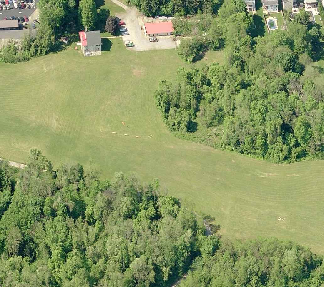
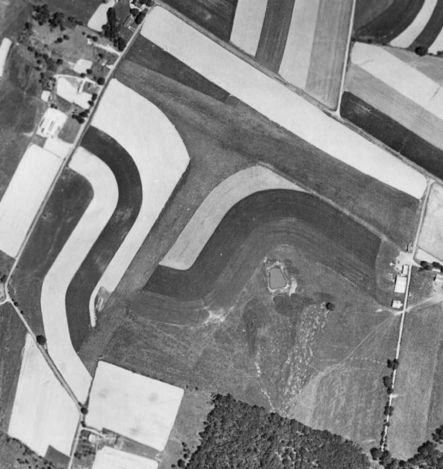
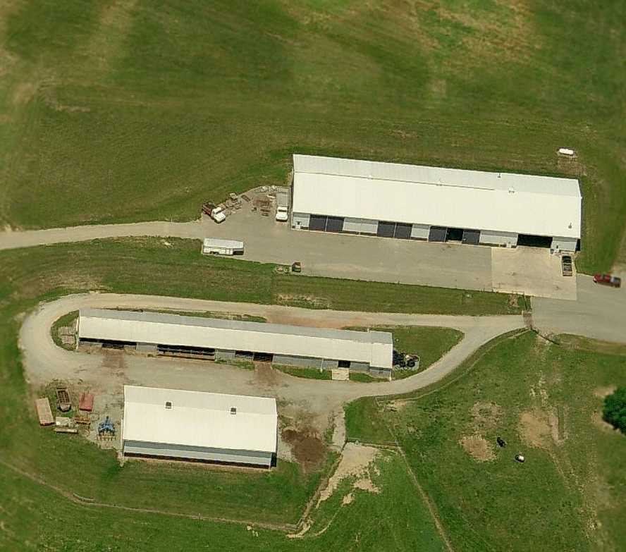
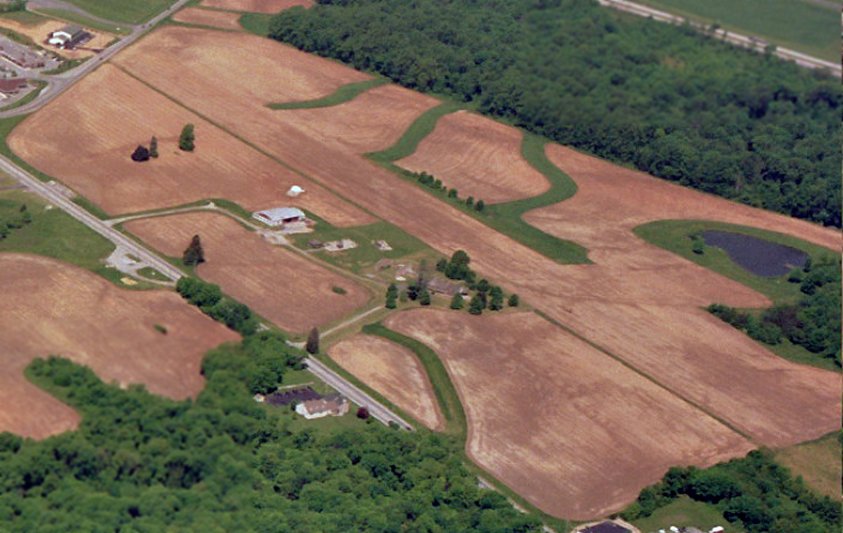
A 9/2/22 aerial view by Ed Figuli looking northwest at McGinness Airport.
The runways remained intact & kept clear, but the 2 closed-runway “X” symbols seen in 2014 were gone.
McGinness Airport is located southwest of the intersection of Manor Street & South 12th Street.
____________________________________________________
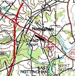
Oxford Airport, Nottingham, PA
39.742, -76.01 (Southeast of Lancaster, PA)
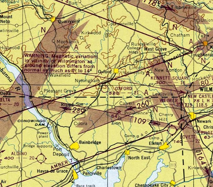
Oxford Airport, as depicted on the October 1947 Washington Sectional Chart (courtesy of Walter Beachell).
The Oxford Airport was established at some point in 1947,
as it was not yet depicted on the April 1947 Washington Sectional Chart (according to John Voss).
The earliest depiction of the airfield which has been located
was on the October 1947 Washington Sectional Chart (courtesy of Walter Beachell).
It depicted Oxford as having a 2,100' unpaved runway.
Eric Grubb reported, “My grandfather, Atley Hansen, was the owner & operator from its inception in the 1940s.”
until it was closed permanently in the late 80s.”
The earliest photo of Oxford Airport which has been located was a 1952 aerial view.
It depicted the field as having 2 grass runways, with 4 hangars & one single-engine aircraft along the east side.
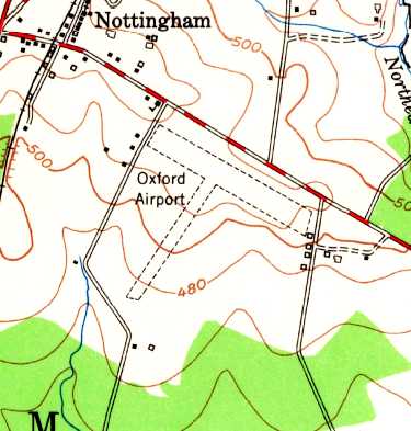
The earliest topo map depiction of Oxford Airport which has been located was on the 1953 USGS topo map.
It depicted Oxford Airport as having 2 unpaved runways, with 4 buildings along the east side.
A 6/7/58 aerial view (from Penn Pilot) depicted Oxford Airport as having 2 grass runways, with several hangars along the east side.
According to Walter Beachell, “The Oxford Airport was located on a dairy farm
owned by Atley Hansen & his brother Carl just outside of Nottingham.
It was about half-mile east of the Herr’s Snack Food plant.
There were 2 turf runways, the longest was 3,000' North/South & the shorter one running East/West.
The airport had an operations building with a small attached shop, a main hangar housing about half-dozen planes,
and 3 smaller hangars that stored a couple of airplanes.”
Walter continued, “The airport began offering flying lessons after World War II
when some of the local veterans used their GI Bill benefits to further their vocational training.
Atley Hansen & Charles 'Dutch' Twyford who offered the flying lessons were Naval flight instructors during the war.
Dutch lived on the airport property, serving as the on-site farm mechanic
as well as offering flying instruction & mechanical services to the locals.
I can remember Dutch telling tales of the vets keeping themselves busy as they waited their turn in the cockpit,
as in one case, by making an anemometer out of salvaged auto parts
and calibrating it by driving down a road holding the unit outside as they matched the airspeed with the car’s speedometer.
There must have been quite a few vets taking flying lessons
as many of their old pilot logs were still in a desk drawer when I started flying in 1967.
I saw at least 40 or 50 log books in that drawer.
When asked if I wanted to keep mine there, I politely declined, as I still have it.”
The July 1961 Philadelphia Local Aeronautical Chart (courtesy of Tim Zukas)
depicted Oxford Airport as having a 2,100' unpaved runway.
According to Walter Beachell, Oxford gained “a T-hangar that was built in the mid 1960s.
My association with the airport began in 1967 when I began taking flying lessons at the age of 16.
The airport was a big part of my life from 1967-74 where I spent many Saturdays taking flying lessons.”
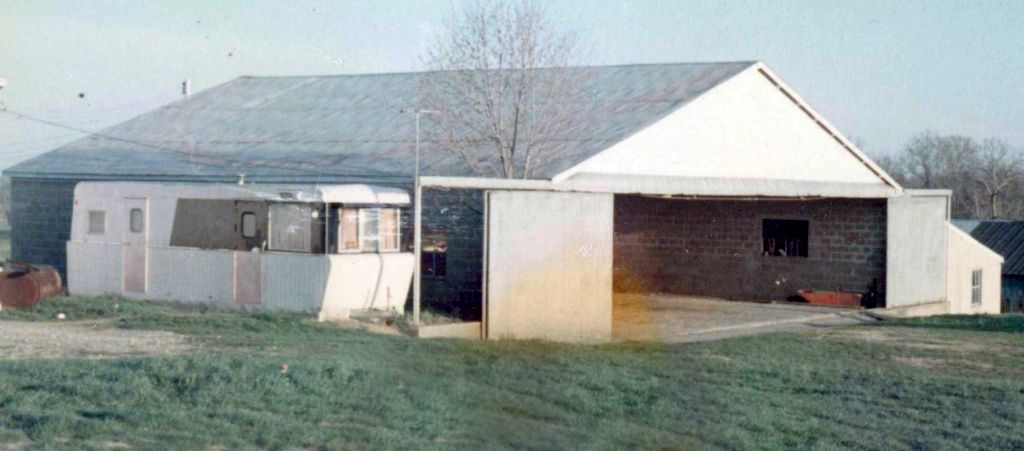
A 1968 photo of Dutch's trailer & the Oxford main hangar (courtesy of Mike Ciosek).
An April 1968 aerial view by Walter Beachell looking East-Northeast at the hangars of Oxford Airport.
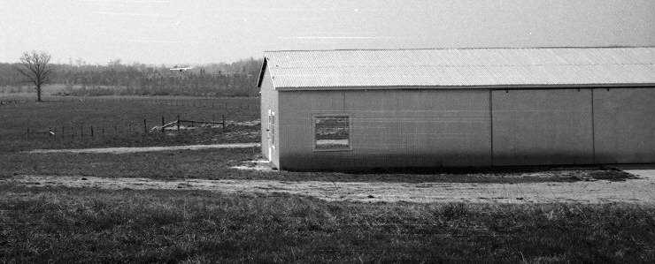
An April 1968 photo by Walter Beachell looking South-Southwest at at T-hangar at Oxford Airport.
Note the Cessna 150 taking off the background, to the left of the hangar.
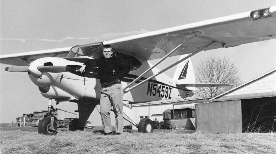
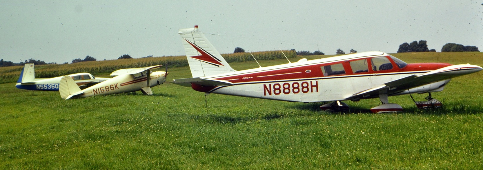
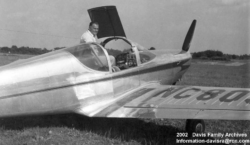
An April 1968 photo of Walter Beachell in front of a Piper PA-22 Colt at Oxford Airport.
A 7/4/71 aerial view of Oxford Airport, showing 2 grass runways & several hangars on the east side.
At some point between 1958-71 the former northeast/southwest runway had been replaced with a longer northwest/southeast runway.
A closeup from the 7/4/71 aerial view of Oxford Airport, showing 7 single-engine aircraft parked on the east side of the field.
A Summer 1971 aerial view by Walter Beachell looking north at Oxford Airport,
showing several planes parked on the east side of the field.
Walter continued, “One April in the early 1970s a strong nighttime windstorm lifted the main hangar’s roof off its supporting walls.
When the roof came back down, it collapsed one of the walls,
dropping the support trusses almost to the floor destroying one or two airplanes & damaging several others.
One of the main beams fell onto a T-6 damaging it, but sparing other airplanes as it kept the beam from falling all the way to the floor.
The main hangar was torn down & replaced with a smaller Quonset-type hangar.
The T-6 was repaired & continues to fly in the area to this day.
A Stinson L-5 lower attached hangar was destroyed when debris from the concrete wall fell onto it.”
Walter continued, “I was most active at the airport in 1973,
as I had graduated college, had a full time job & a little pocket money to spend.
Two other fellows & I purchased an Aeronca L-16 for $2,100 in the fall of 1973 that we hangared at Oxford.
I had a great time flying it all around the local airports.
By the following summer I sold my interest in the L-16 & continued to rent airplanes off & on until 1976.
By that time Dutch had sold his shop equipment to a local sod farmer whose shop had burned down.
I recall Dutch saying he’d never get an offer to buy everything, and so he did.
Dutch’s shop was always cluttered, but functional.
He worked doing odd jobs for the local farmers & even stored a friend’s Bugatti for a short while.
I was surprised when I stopped by to visit in 1975 that the old shop was totally bare to the walls.
It turns out it was once a hangar & it was once again used as a hangar.”
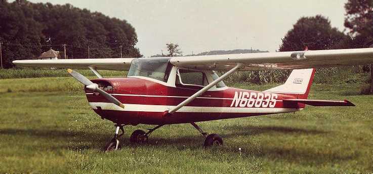
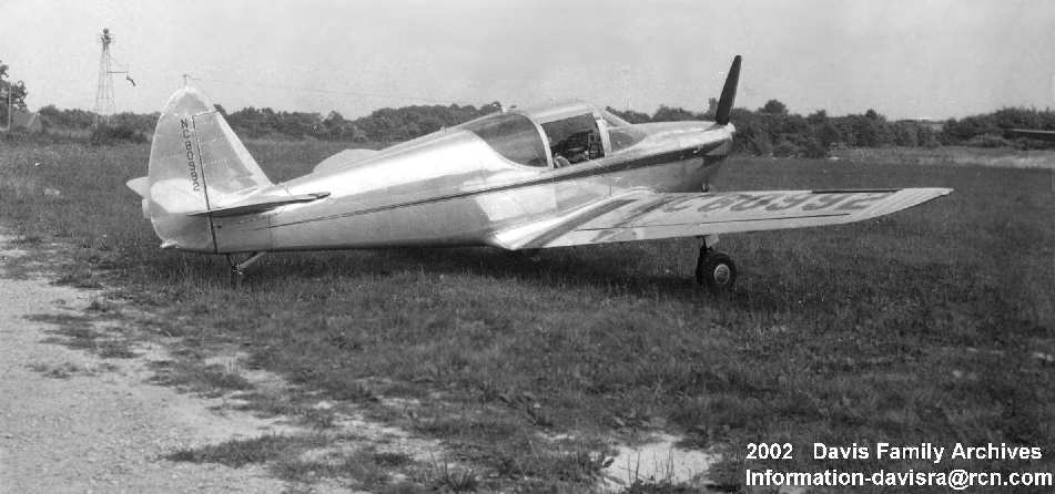
A 1973-74 photo by Larry Toto of a Cessna C150 at Oxford Airport. Larry recalled, this was “Dutch's plane in which I soloed.”
Larry Toto recalled, “Oxford Airport... I started flight lessons there with Charles 'Dutch' Twyford in a C-150 in 1973.
I flew with Dutch for my 1st 40 hours when he lost his medical & sold or gave his plane to a nephew, as I recall him telling me.
I saw Mr Hansen on each visit... he would take my money. I have a picture of Dutch's Cessna (N6683S).
I was 19 when I started lessons. I would drive my dad's 1959 Lambretta motor scooter from Upper Darby, PA for the 1 hour trip with just enough money for a lesson.
Dutch charged me $15 for dual & $12 solo. I was earning minimum wage of $1.65/hr, so I had to work 8 hours for a lesson.
I remember telling Dutch that I have $12, and we would fly $12 worth... or $16 & we would fly $16 worth of time.
We often sat around in the chairs outside the flight office before a flight waiting for the plane to come back from a local flight.”
Larry continued, “Dutch soloed me when I had the low 20s hours... but I remember telling him that I felt ready when I had 16 or so hours.
I have vivid memories of him yelling 'Back...back...back...back...' when I was landing, to have me get the nose up farther on touchdown.
Sometimes he grabbed the yoke & gave it a yank to make his point.
On calm days, we took off downhill on the north-south runway & landed uphill.... traffic often conflicted.
You had to watch all directions for traffic, especially oncoming landing traffic while you were preparing to takeoff.
We never called the runways by number. We said, '83 Sierra landing to the north.'
There was also the shorter runway heading more toward the east & west.
I remember taking my friend flying into Oxford after I had my license & just barely clearing those trees at the west end on a calm day.
I yelled, 'WE MADE IT!' after wondering if we would toward the end of that takeoff.
My friend looked at me and said, 'You mean you didn't know for sure?'”
Larry continued, “The north/south runway was sometimes soggy at the low point after a rain & they would not use it for several days at times.
And when you were rolling south down the runway & downhill for takeoff,
you normally made several false leaps into the air because the hill was a series of bumps & valleys
that launched you a couple of times before you had sufficient flying speed.
It was most interesting when the breeze favored departing to the north, up the hill.
You had to get off the ground down on the low part of the hill then outclimb the runway.
We rarely ever used the short runway with me & Dutch in the plane together, except when the wind was very favorable for that,
because together we put the plane near gross weight. I remember how that plane climbed so fast when he got out for my first solo flight.”
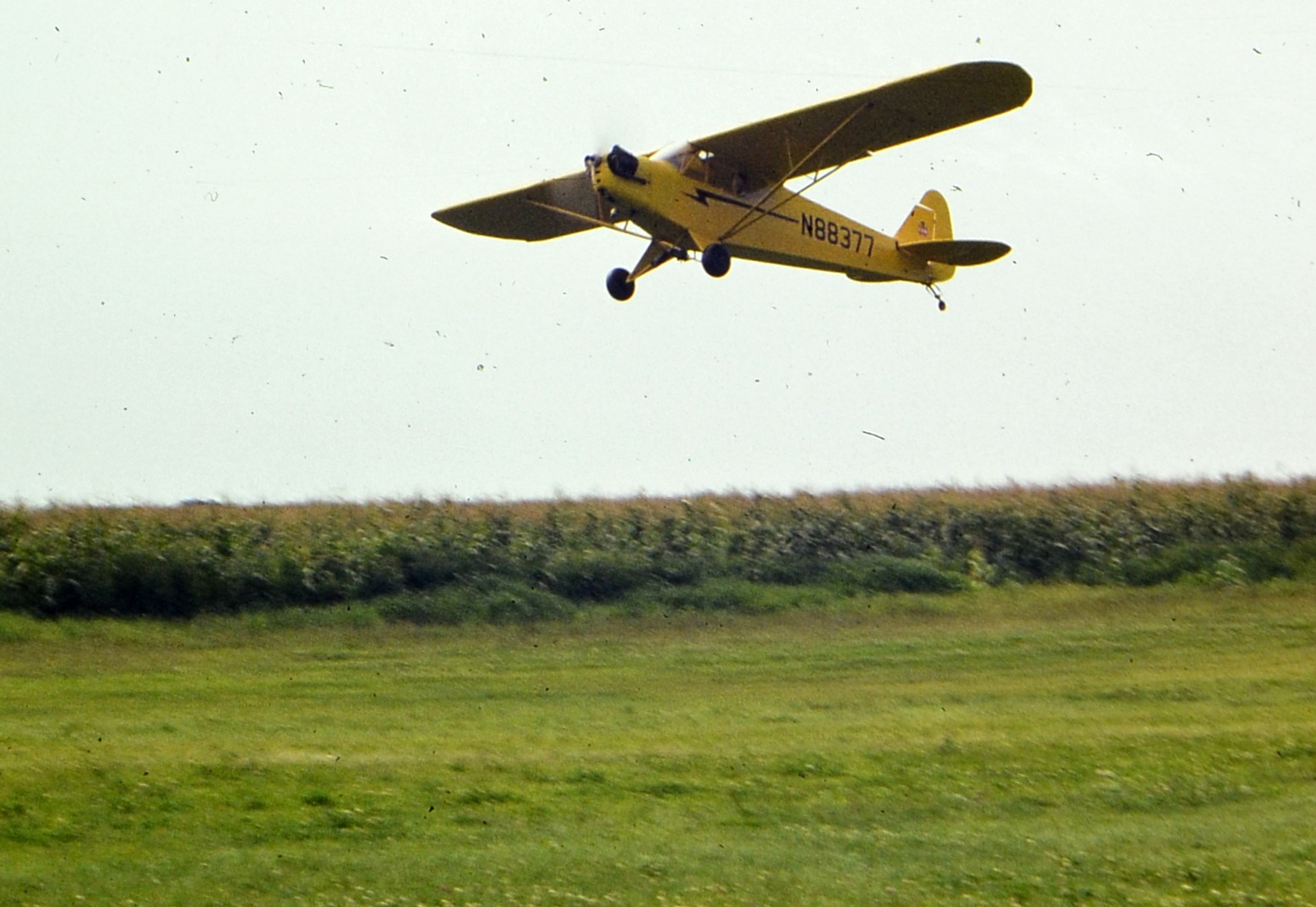
A 1974-75 photo by Larry Toto of a Piper J3 Cub departing to the south (downhill) at Oxford Airport.
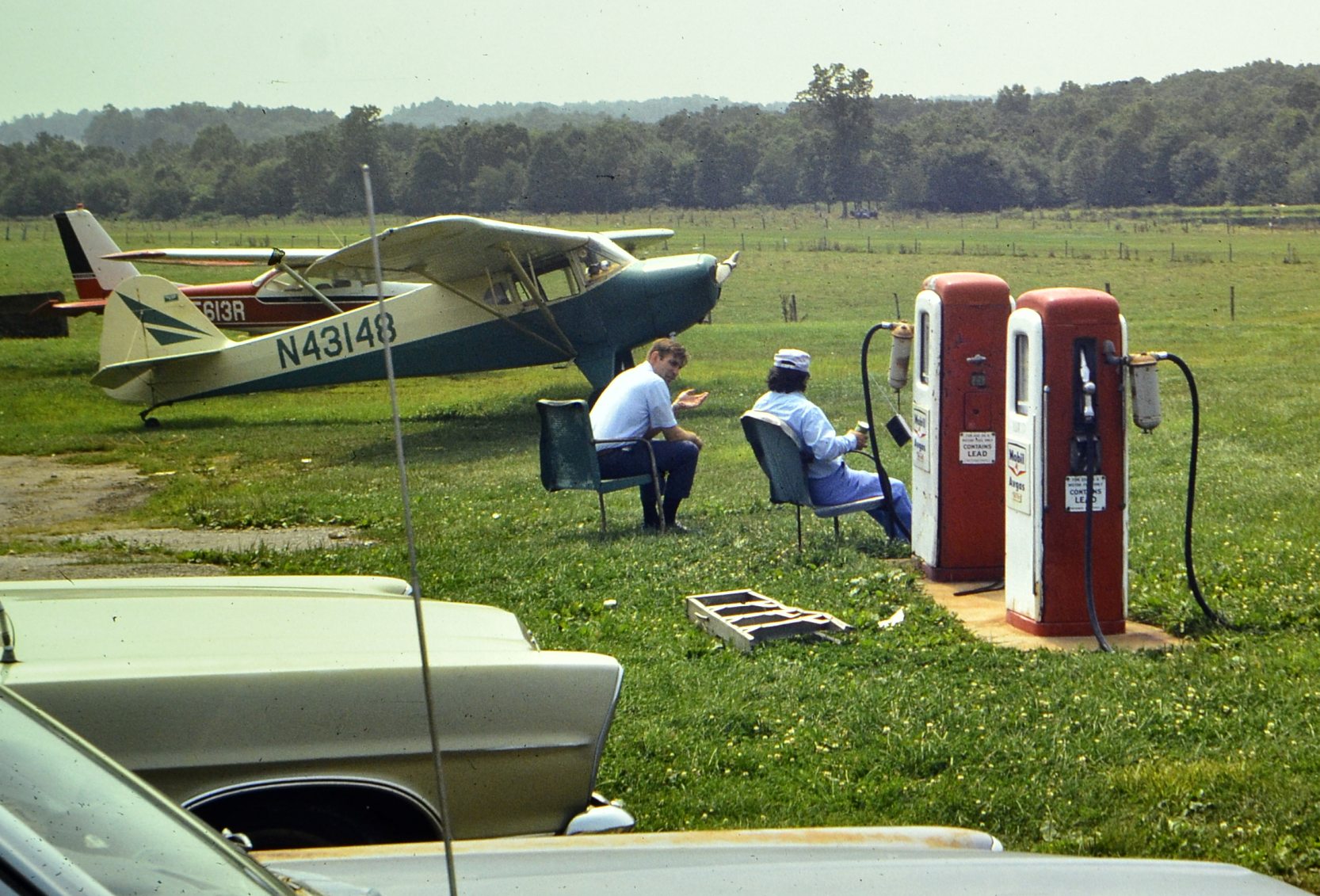
A 1974-75 photo by Larry Toto of 2 men hanging out at the Oxford Airport gas pumps, in front of a Cessna 172 & Taylorcraft.
Larry Toto recalled, “This was the best we could do for passing time at Oxford Airfield.”
A 1974-75 photo by Larry Toto of “the flat south end of the North/South runway” at Oxford Airport.
A 1974-75 photo by Larry Toto of a Mooney, Cessna, and Piper at Oxford Airport, with “the East/West runway just visible over the cowl of the Piper.”
The last aeronautical chart depiction which has been located of Oxford Airport was on the March 1981 Washington Sectional Chart (courtesy of Ron Plante).
It depicted Oxford as a public-use airport having a 2,800' unpaved runway.
The last depiction which has been located of the Oxford Airport was on the 1982 USGS topo map.
It depicted Oxford Airport as having 2 runways.
The last listing of the Oxford Airport which has been located was its inclusion in the 1983/84 PA Airport Directory (according to Chris Kennedy).
According to New Garden Aviation, “Oxford Airport lost [closed] due to PennDOT's new-at-the-time regulation
that prohibited the transfer of Airport operating licenses without relicensing the airport to the new 1984 Criteria.”
Walter continued, “Around the early 1980s the airport ceased to exist;
the dairy farm was purchased in 1983 by Herr’s snack food business in Nottingham & became the Herr Beef Farm.
Herr’s uses the beef farm to progressively dispose of a portion of their plant’s waste stream located a short distance away.
I vividly remember early in my flying lessons taking off on the East/West runway flying over the plant,
passing through the frying operation’s exhaust plume & being enveloped by the aroma of freshly cooked potato chips.”
Eric Grubb reported, “My grandfather, Atley Hansen, was the owner & operator until it was closed permanently in the late 1980s.”
Walter continued, “In the late 1980s I frequently flew commercial flights out of Philadelphia Airport on business.
On one of those flights the plane flew over the old Oxford Airport.
Naturally, I had a window seat & was able to look down from about 15,000' to see the site of the old airport.
What a sense of déjà vu as long ago I was a young man on the airport looking up as the airliners flew overhead.”
Oxford Airport was no longer depicted on the 1989 Washington Sectional Chart (courtesy of Jonathan Westerling).
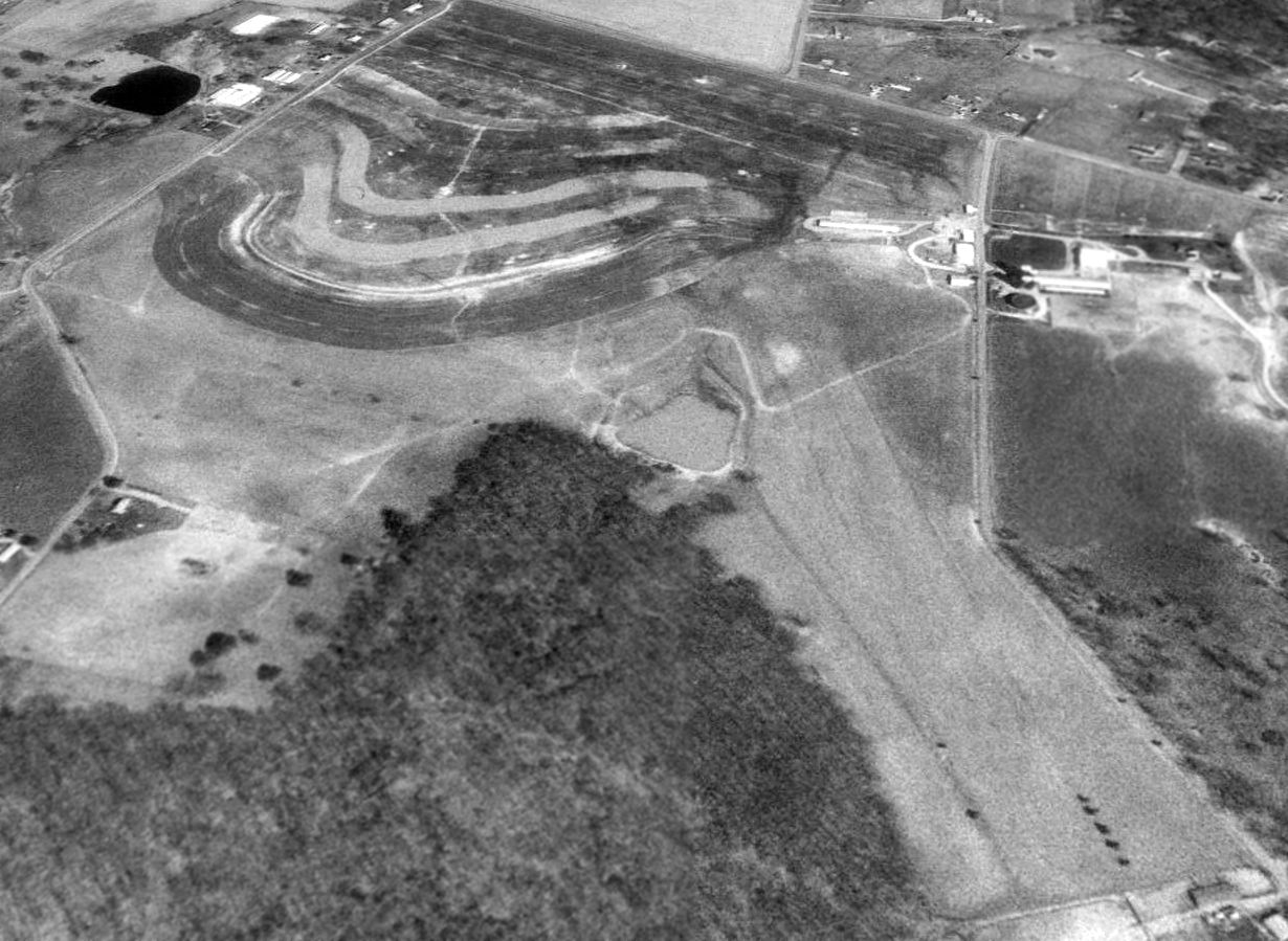
A 1992 USGS aerial view looking north showed that the site of the Oxford Airport remained largely intact, with the runways having reverted to farmland,
but the hangars remained along the east side.
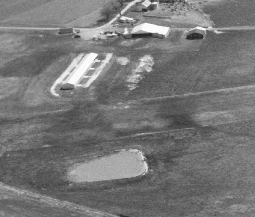
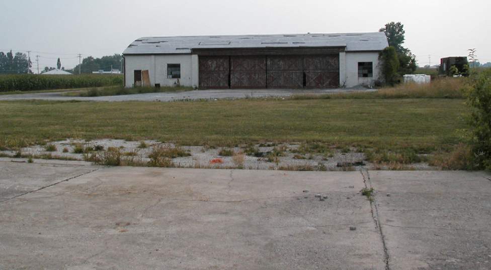
A circa 2006 aerial photo looking north at the former T-hangar which remains standing at the site of the Oxford Airport.
A May 2008 photo by Walter Beachell of the former T-hangar, with a new barn behind it.
Walter observed, “The operations & shop building, along with the other hangars were torn down long ago.
The only building that remains is the T-hangar that is now full of farm equipment.
The turf runways were converted back to pastures.
Several new buildings were erected to house farm machinery & horses.”
A May 2008 photo by Walter Beachell looking south-southwest toward the former runway.
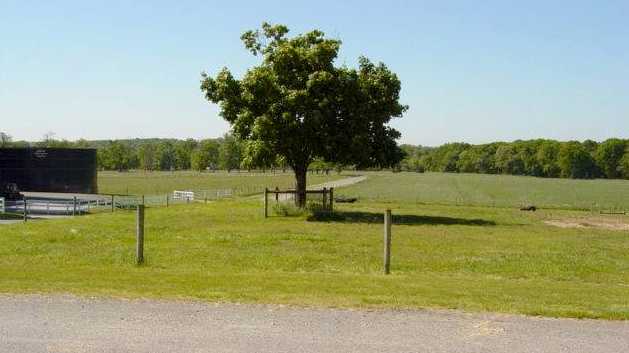
Walter observed, “One fixture that did remain is a lone Maple tree that was located between the operations building & the main hanger.”
The maple tree is the same one depicted in the 1968 Tri-Pacer photo above.
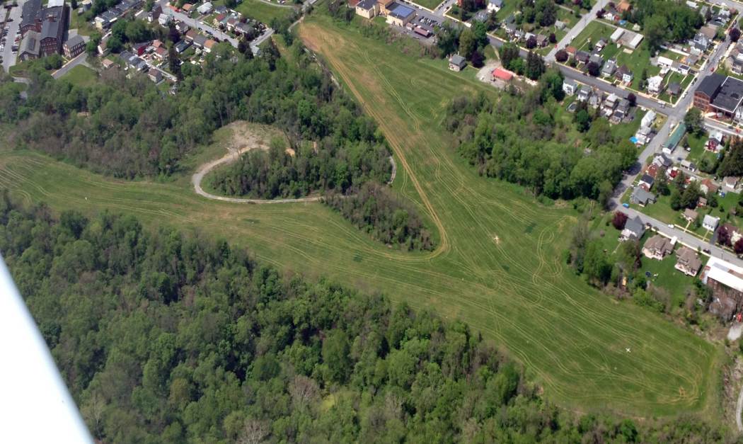
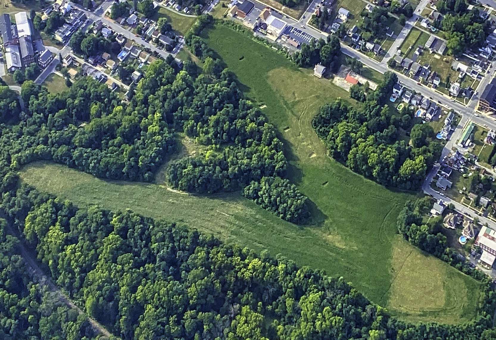
A 2016 aerial view looking north showed that the site of the Oxford Airport remained largely intact, with the runways having reverted to farmland,
and the T-hangar remaining along the east side.
The site of Oxford Airport is located west of the intersection of East Christine Road & Airport Road, appropriately enough.
____________________________________________________
Lancaster Airport (original location), Lancaster, PA
40.07, -76.32 (Northeast of Baltimore, MD)
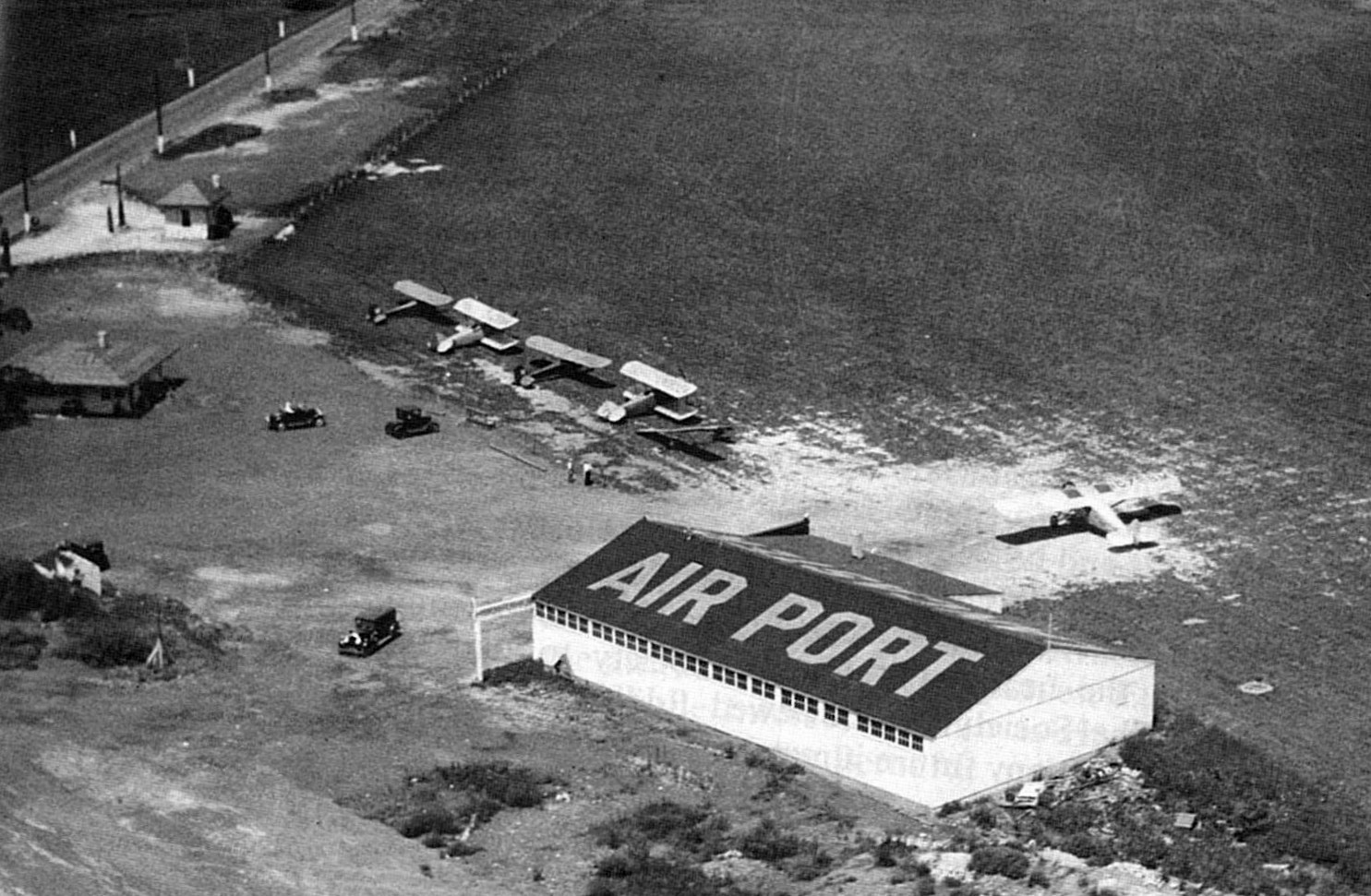
A 1931 aerial view looking northwest at Lancaster Airport (courtesy of Kim Hubner).
The original airport for the town of Lancaster was located adjacent to the northwest side of the town.
The date of construction of Lancaster Airport has not been determined.
The earliest depiction which has been located of Lancaster Airport was a 1931 aerial view (courtesy of Kim Hubner).
It depicted 5 single-engine monoplanes & biplanes on the side of a grass airfield,
with a hangar painted with “Air Port” on its roof, and 2 smaller buildings.
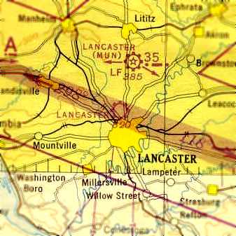
The earliest aeronautical chart depiction which has been located of Lancaster Airport was on the August 1932 NY Sectional Chart.
It depicted Lancaster as a commercial/municipal airport, with aeronautical beacon #35 along a commercial airway.
Lancaster Airport, as depicted on the 1935 Washington Sectional Chart.
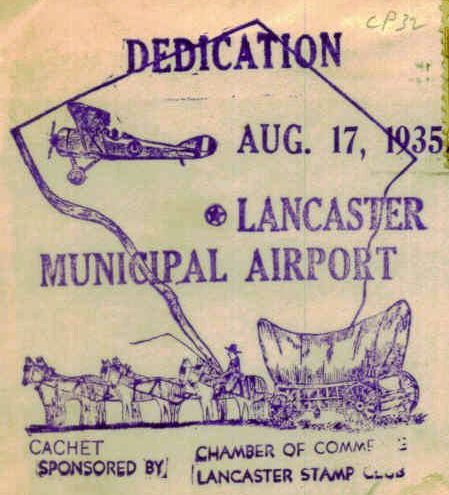
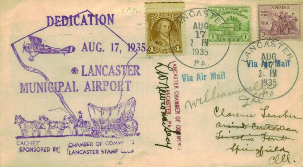
A postmark commemorated the 8/17/35 Dedication of the Lancaster Municipal Airport.
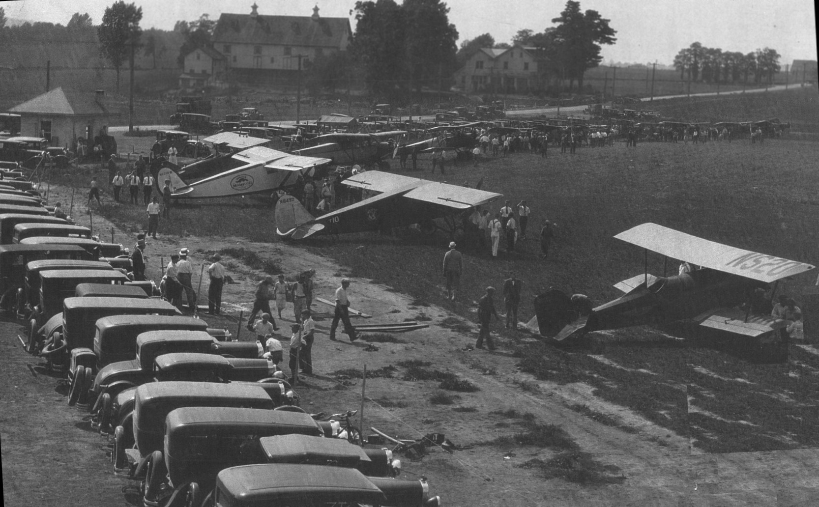
A circa 1930s photo looking west at the first airshow at the Lancaster Municipal Airport (courtesy of Kim Hubner),
showing spectators & over a dozen single-engine monoplanes & biplanes.
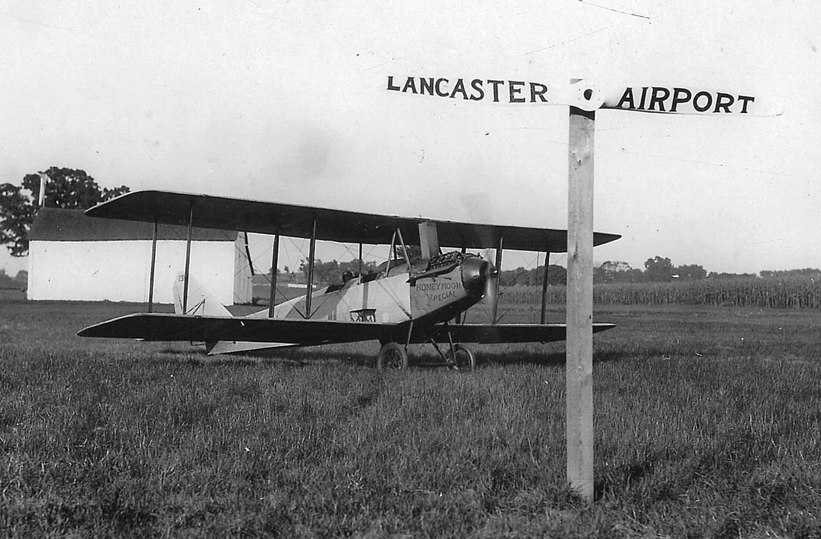
A circa 1930s photo of a sign for Lancaster Airport fashioned from a propeller (courtesy of Kim Hubner),
with a biplane (model undetermined) named the “Honeymoon Special”.
A circa 1930s aerial view looking northeast at Lancaster Airport (courtesy of Kim Hubner), showing a single-engine monoplane, the hangar with “Air Port” painted on its roof, and a beacon tower.
According to Erik Wagner, the original Lancaster Airport was located “on Manheim Road northwest of Lancaster.
A man I talked to today at Smoketown Airport said he learned to fly there.”
The Airport Directory Company's 1937 Airport Directory (courtesy of Bob Rambo)
described the Lancaster Airport as a commercial field located 2.5 miles northwest of the town.
It was said to consist of an irregularly-shaped sod field, measuring 2,240' x 1,840'.
A hangar on the south side of the field was said to be marked with “Lancaster Airport”.
A 4/29/40 aerial view of the original Lancaster Airport showed the field to consist of an irregularly-shaped grass field, marked with a circular airport symbol in the center.
Several buildings were located along the south side of the field, one of which appeared to be marked with “Lancaster Air Port”.
The Lancaster Airport was not depicted at all on the 1943 USGS topo map.
It may have gone through a period of temporary closure during WW2, like many other small general aviation airports.
A circa 1943-45 aerial view looking north at the Lancaster Airport
from the 1945 AAF Airfield Directory (courtesy of Scott Murdock)
depicted the field as an open grass area, with several buildings along the south side.
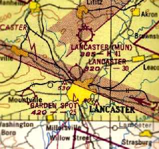
By the time of the 1945 NY Sectional Chart, the original Lancaster Airport (adjacent to the northwest side of the town)
had been joined by the new Lancaster Municipal Airport, further out of town to the north-northeast.
The original Lancaster Airport was depicted as a commercial/municipal field.
The 1945 AAF Airfield Directory (courtesy of Scott Murdock) described Lancaster Airport
as an 85 acre irregularly-shaped property within which were 3 sod runways, with the longest being the 2,300' east/west strip.
The field was said to have 3 hangars, the largest being a 100' x 50' wooden structure,
and to be privately owned & operated.
The last aeronautical chart depiction which has been located of the original Lancaster Airport was on the 1950 NY Sectional Chart.
It depicted the original Lancaster Airport as having a 3,000' unpaved runway.
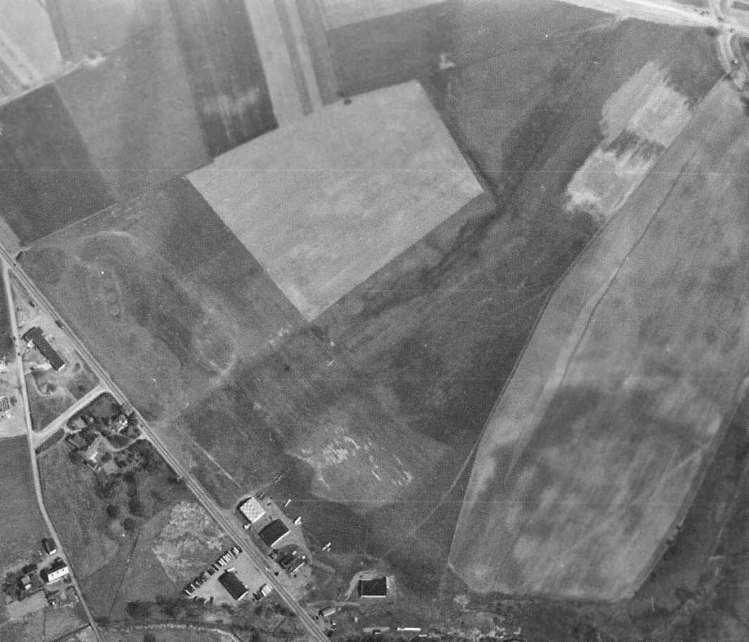
The last photo which has been located of the original Lancaster Airport was a 4/21/51 USDA aerial view.
It depicted the field as an irregularly-shaped grass field, with 3 hangars & 3 single-engine aircraft at the south end.
Tim Kauffman recalled, “My father was an Airframe & Powerplant Mechanic at Rittenour Flying Service that was located there.”
He also reported that the airport closed in 1953.
The original Lancaster Airport was presumably closed due to competition from the newer & larger Lancaster Municipal Airport to the northeast.
The original Lancaster Airport was no longer depicted on the 1955 Washington Sectional Chart or the 1956 USGS topo map.
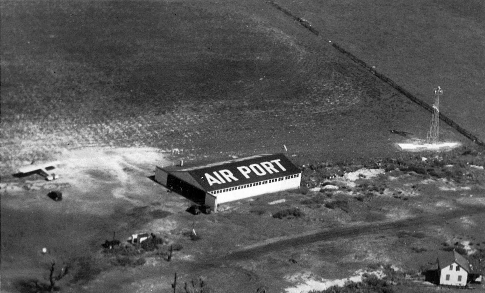
By the time of a 6/7/58 aerial photo, much of the site of the original Lancaster Airport had been covered with buildings,
but the 1930s-era hangar remained standing on the south side of the property.
By the time of a 7/5/71 aerial photo, the site of the original Lancaster Airport had been covered with buildings,
but the 1930s-era hangar remained standing on the south side of the property.
A circa 2006 aerial view looking east at the 1930s-era hangar which remains standing
on the south side of the site of the original Lancaster Airport.
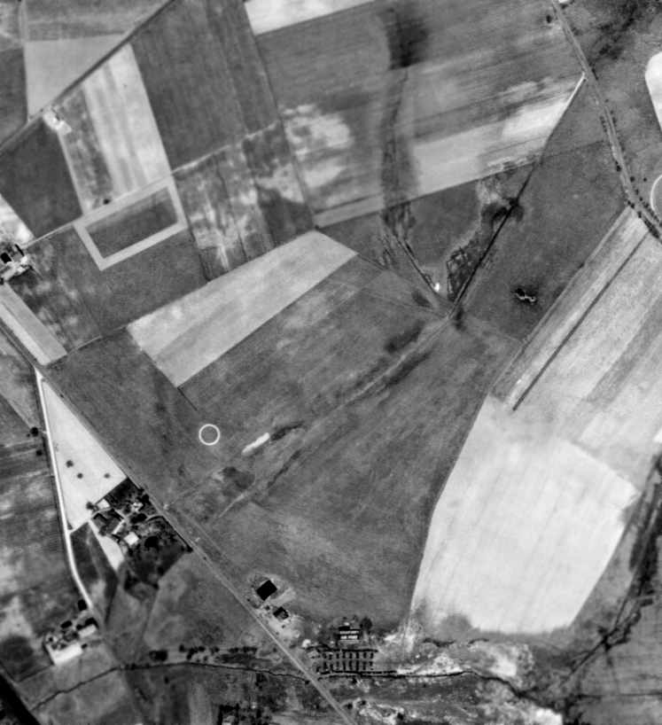
As seen in a circa 2006 aerial photo (courtesy of Chris Kennedy), the site of the original Lancaster Airport has been heavily redeveloped,
with the exception of the hangar, which is visible at bottom-right.
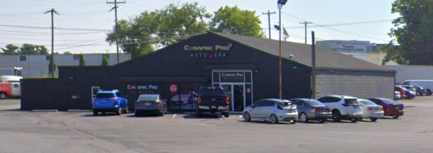
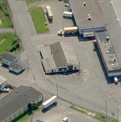
An August 2022 photo looking northeast at the 1930s-era hangar which remains standing on the south side of the site of the original Lancaster Airport, reused as the Ceramic Pro Autospa.
The site of the original Lancaster Airport is located east of the intersection of Manheim Pike & Steel Way.
____________________________________________________
Stoltzfus Field (N08), Coatesville PA
39.984, -75.864 (West of Philadelphia, PA)
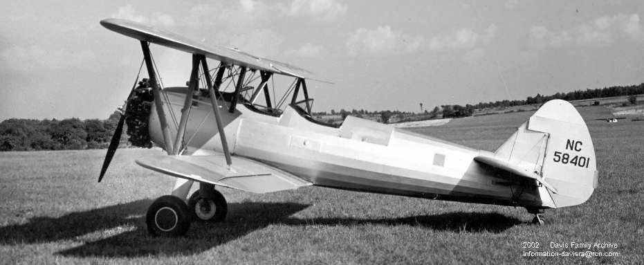
A circa 1940s photo of a Stearman at Stoltzfus Field (courtesy of Rick Davis).
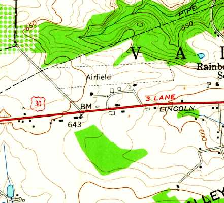
This small airfield is located on the north side of West Lincoln Highway,
just across the street from the present-day Chester County Airport.
The exact date of construction of Stoltzfus Field is unknown.
A 9/12/37 aerial view did not appear to show any sign of an airfield having yet been established.
Stoltzfus Field was not yet listed among active airfields in the 1945 AAF Airfield Directory (courtesy of Scott Murdock).
According to Rick Davis (whose parents flew out of Stoltzfus Field), his mother learned to fly there around 1945-46.
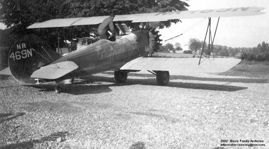
A circa 1940s photo of a Travel Air 4-S (c/n 1383) at Stoltzfus Field (courtesy of Rick Davis).
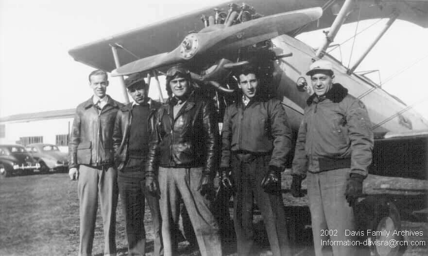
A circa 1940s photo of Harry Davis & friends in front of a Stearman at Stoltzfus Field (courtesy of Rick Davis).
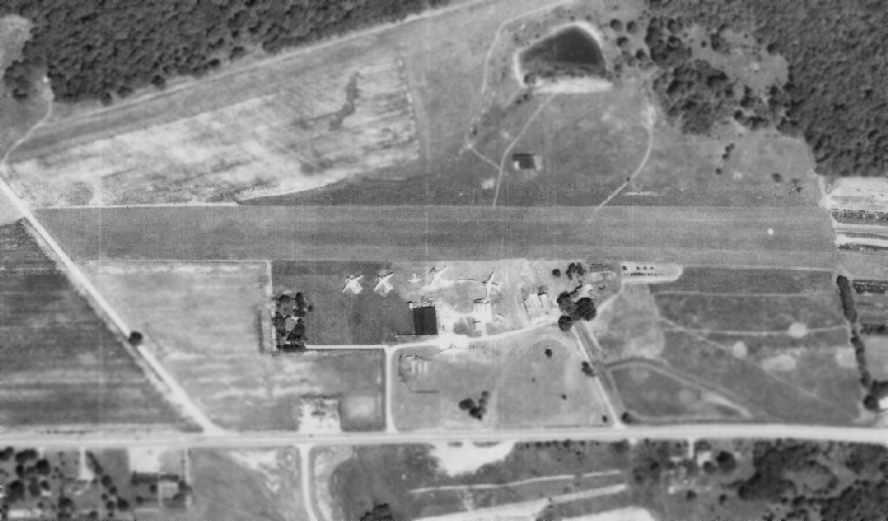
The earliest photo which has been located showing the complete extent of Stoltzfus Field was a 7/8/50 USGS aerial view.
It depicted the field as having a single east/west grass runway, with 8 single-engine aircraft parked around a hangar on the south side.
Stoltzfus Field was not depicted at all on the July 1953 Washington Sectional Chart,
even though it had apparently already been operating as a small private airfield for a few years.
Stoltzfus Field was labeled simply "Airfield" on the 1953 USGS topo map.
It was depicted as an unpaved east/west runway, with several buildings along the south side.
Note that the eventual Chester County Airport was not yet depicted across the road to the south.
The earliest aeronautical chart depiction of Stoltzfus Field which has been located was on the January 1954 Washington Sectional Chart,
which depicted it as a private field with a 1,700' unpaved runway.
Harry Davis climbing into a Swift at Stoltzfus Field, circa 1950s (courtesy of Rick Davis).
A Swift at Stoltzfus Field, circa 1950s (courtesy of Rick Davis).
Ken Stoltzfus recalled, “I grew up on the Stoltzfus Private Airport, and my father was Chris Stoltzfus.
We had many Stearmans, Twin Beechs, DC-3s & TBMs, a B-17, 2 Chase YC-122C Boxcars, 2 Grumman FM-2 Wildcats, and a DGA-15.”
Stoltzfus Field, as depicted on the August 1957 Washington Sectional Chart.
It depicted Stoltzfus as a private field with a 1,700' unpaved runway.
Stoltzfus Field was no longer depicted on the March 1958 Washington Sectional Chart, or subsequent aeronautical charts.
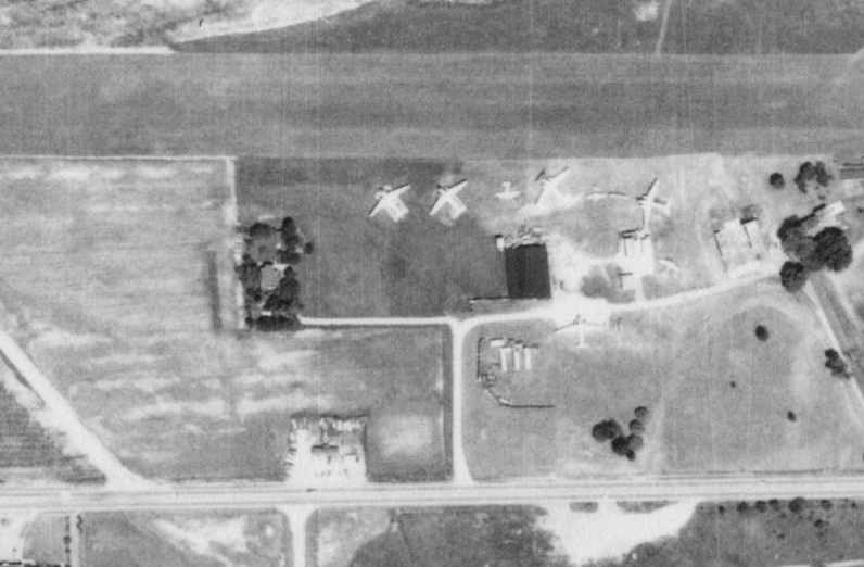
An 8/9/58 aerial view of Stoltzfus Field (from Penn Pilot), showing the single east/west grass runway.
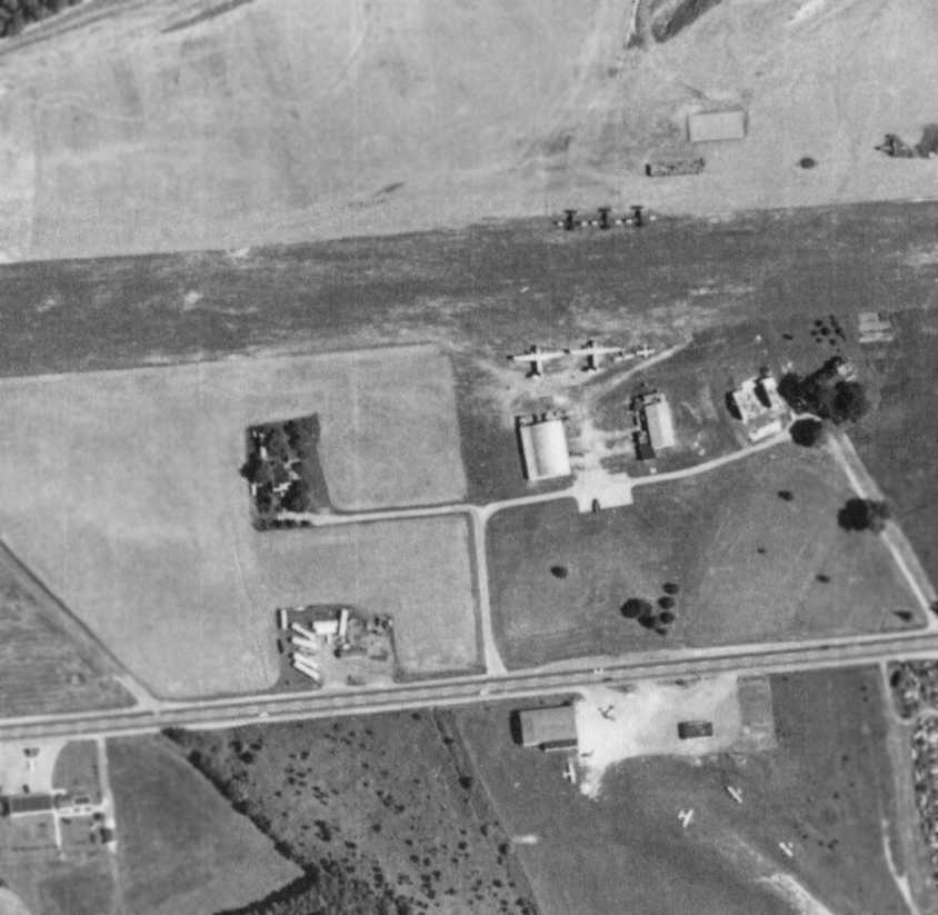
A closeup from the 8/9/58 aerial view of Stoltzfus Field (from Penn Pilot),
showing 5 large unidentified military surplus planes, along with 2 smaller single-engine aircraft, along with the hangar & other buildings.
Also note the 5 single-engine aircraft right across the street at the adjacent Chester County Airport.
The 1962 AOPA Airport Directory described Stoltzfus Field as having a single 3,000' sod Runway 9/27,
along with the note, "Caution: Emergency use only."
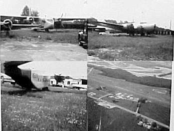
A series of June 1965 photos by Deane McKercher of Stoltzfus Field, including one of a B-17.
The last aeronautical chart depiction which has been located of Stoltzfus Field was on the October 1966 Philadelphia Local Aeronautical Chart (courtesy of John Ferrara).
It depicted Stoltzfus as a private field with a 2,800' unpaved runway.
A circa 1966 aerial view (courtesy of Virgil Fenn) of Stoltzfus Field (north of the road),
showing how close it was located to the Chester County Airport (south of the road).
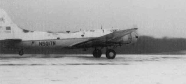
A remarkable photo (courtesy of Virgil Fenn) of a B-17 bomber, N5017N, taking off in 1966 from Stoltzfus Field,
with a crew of Virgil Fenn (pilot) & James Earl Price (copilot).
According to John Burtner, as of 2008 this B-17 was still flying (“It's owned by the EAA and is known as 'Aluminum Overcast'”).
Virgil Fenn recalled, “Dothan Aviation Corporation purchased B-17, N5017N, from Chris Stoltzfus in 1966
to add to our fleet of aircraft contracting to the US Department of Agriculture to try to get rid of the imported fire ant.
I only had enough fuel to take off from Stoltzfus Field & fly the 1 mile to the main [Chester County] airport.
This probably save my life & my co-pilot's life as the airplane had a fire on takeoff.”
Karl Stoltzfus recalled, “When [the B-17] landed, the supercharger (#4 engine) had overheated
and burned through the supercharger oil tank supply line, and we had a very serious fire going when [the B-17] pulled in.
Only by the very quick thinking of my Uncle John Stoltzfus, who ran for a fire extinguisher, and put the fire out,
were we able to save the airplane.”
According to Rick Davis, Chris Stoltzfus operated the airport.
"He bought WW2 surplus aircraft & converted them for firefighting & ag-dusters.
By the 1970's he had at least 2 B-17's, about 6 or 7 C-47's, and a plethora of PT-17 Stearmans, twin engine Beech's, single engine crop dusters & more.
His property was ringed by a fence made entirely of engine storage drums, from the many engines he must have replaced over the years.
As a child, I distinctly remember riding with Dad past Stoltzfus Aviation & seeing B-17 tailfins protruding over the engine drum fence,
most with the European theater marking still on their dorsal fins."
Rick continued, "Occasionally we would stop in, and one of my memories was staying out from under the engines.
You see, radial engines are air-cooled and have a very loose fit when cool.
They drip oil profusely until they reach operating temperature, and my father reminded me to stay away from the engines running or not.
He didn't need to get too graphic about the consequences of a prop-strike on a child.
I had many, many dreams & plans of flying there, and TV programs (like 12-O'clock High) really fueled my interest."
A 7/5/71 aerial view of Stoltzfus Field, showing the single east/west grass runway, hangar, and several planes.
A closeup from the 7/5/71 aerial photo, showing 8 planes at Stoltzfus Field, including 5 DC-3s/C-47s.
Stoltzfus Field was no longer depicted on the 1975 Philadelphia Terminal Chart.
Rick Davis recalled, "Chris Stoltzfus died on 7/25/81 of a heart attack. I was 21 years old at the time, and crestfallen."
Stoltzfus Field was still listed as an active private airfield in the 1982 AOPA Airport Directory (courtesy of Ed Drury).
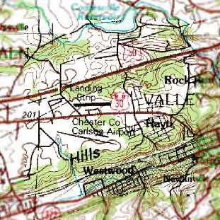
Stoltzfus was labeled simply "Landing Field" on the 1984 USGS topo map.
Note the proximity of the Chester County Carlson Airport, right across the road to the south.
Stoltzfus Field was no longer depicted on the 1998 USGS topo map.
A 5/16/00 aerial view looking west at Stoltzfus Field (from the Dallin Aerial Survey Collection, courtesy of the Hagley Museum & Library)
showed the east/west unpaved runway remained clear, and the hangar, operations building, and remains of a maintenance building still stood on the south side.
A 2001 photo by Jay Cooke of the remaining hangar at Stoltzfus Field.
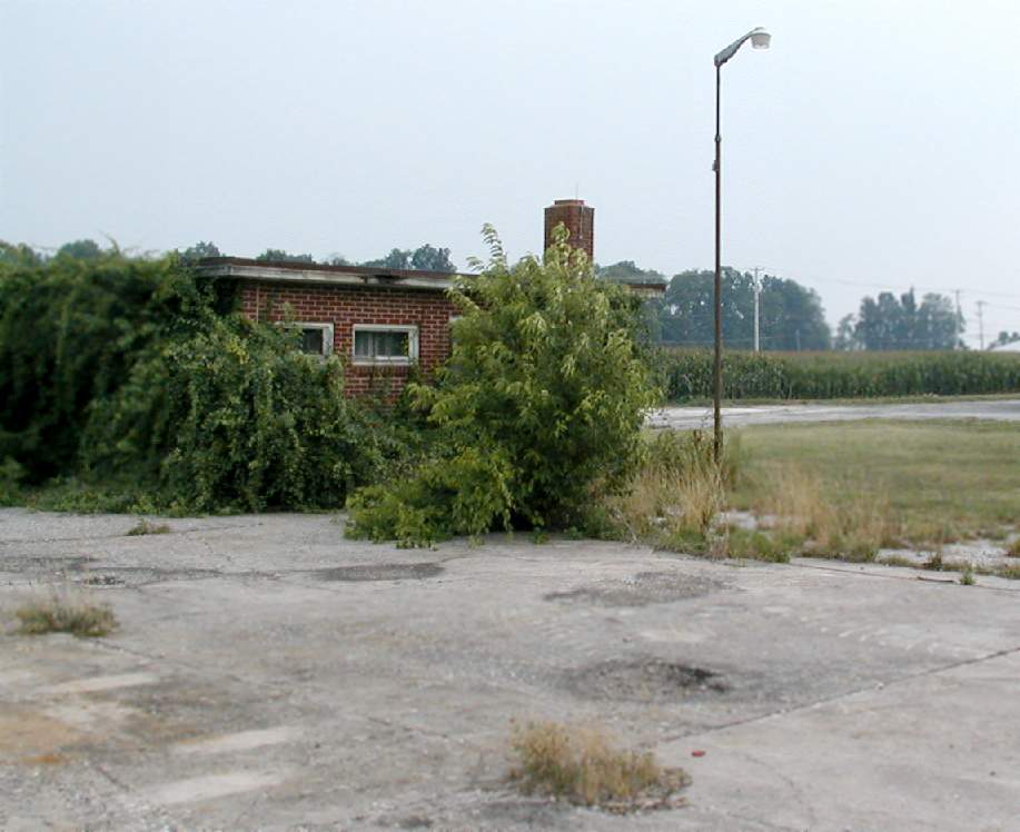
A 2001 photo by Jay Cooke of the remaining operations shack at Stoltzfus Field.
A 2001 photo by Jay Cooke of the remains of the barn that was used as the repair shop at Stoltzfus Field.
According to Rich Kline, "It had a wooden floor, soaked with oil & grease, and they were doing some welding when it caught fire."
Paul Freeman flew over Stoltzfus Field in 2003, and observed that the site is still intact - with the hangar & other buildings still standing.
The surrounding area is experiencing a good deal of development, though,
so it would not be surprising to see the traces of this abandoned airfield removed soon.
Rick Davis reported in 2004, "According to Ken Stoltzfus Sr, they still own the former airfield & currently have an agreement of sale."
A circa 2006 aerial view looking west at the Stoltzfus hangar & other buildings.
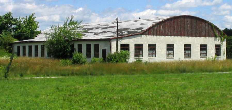
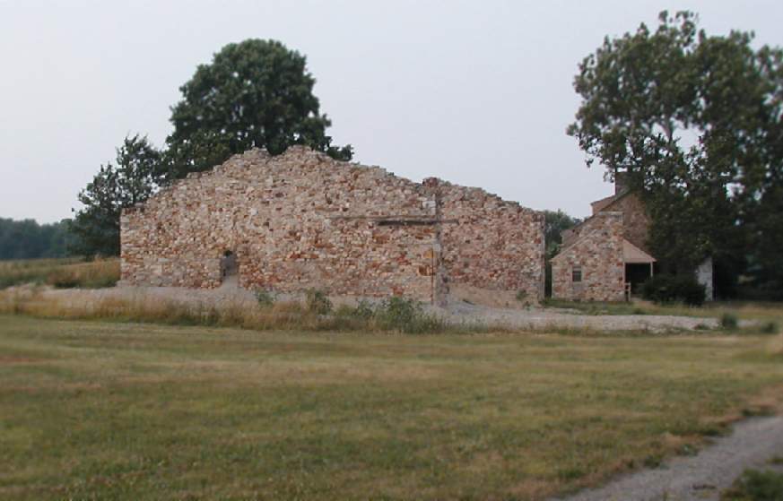
A 2007 photo by Paul Freeman looking northeast at the former hangar which remains standing at the site of Stoltzfus Field.
There was no obvious sign of redevelopment of the property – the former runway area appeared to be planted with corn,
and all 4 buildings (hangar, ops shack, maintenance building, and house) still remained largely intact.
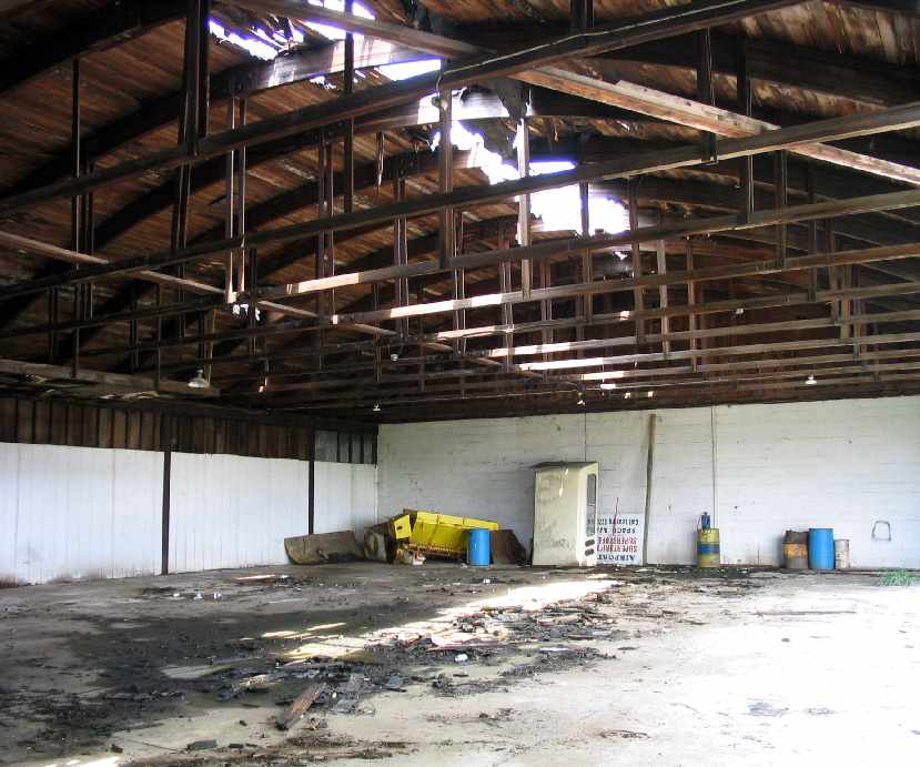
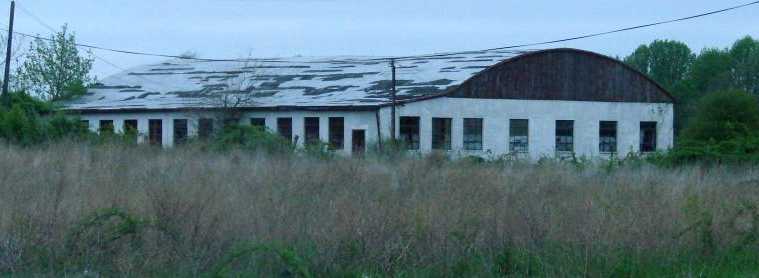
A 2007 photo by Paul Freeman of the interior of the Stoltzfus hangar, showing the hole in the roof.
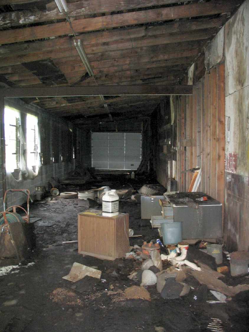
A 2007 photo by Paul Freeman of the former office along the west side of the former Stoltzfus hangar.
A 2007 photo by Paul Freeman of the former operations building at the site of Stoltzfus Field.
A 2008 photo by Rick Davis looking northeast at the former hangar which remains standing at the site of Stoltzfus Field.
A 2010 aerial photo showed Stoltzfus Field's hangar had been removed at some point between 2008-2010.
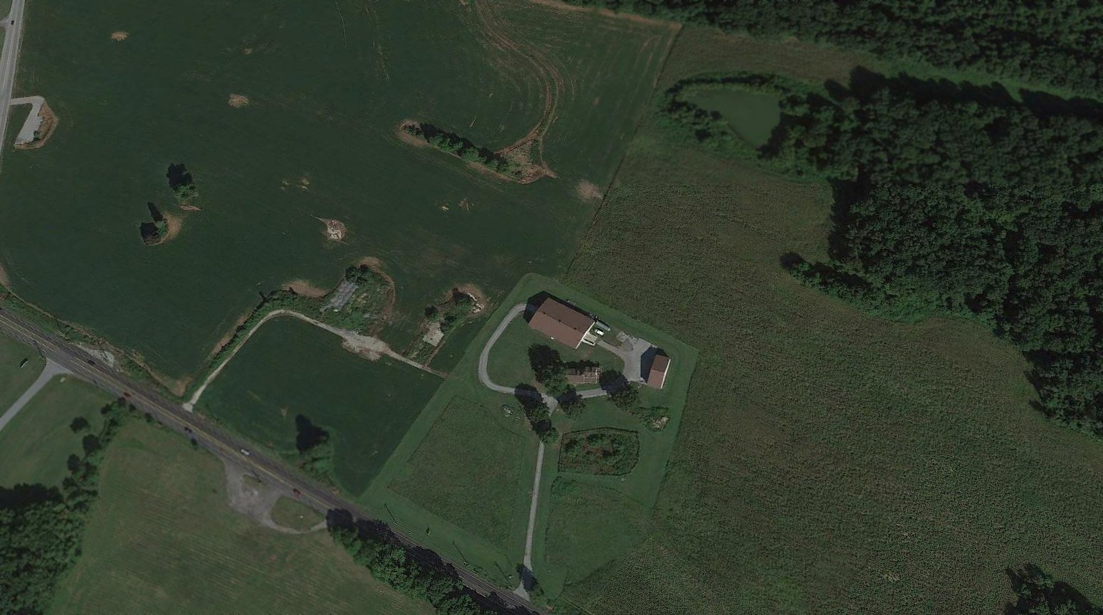
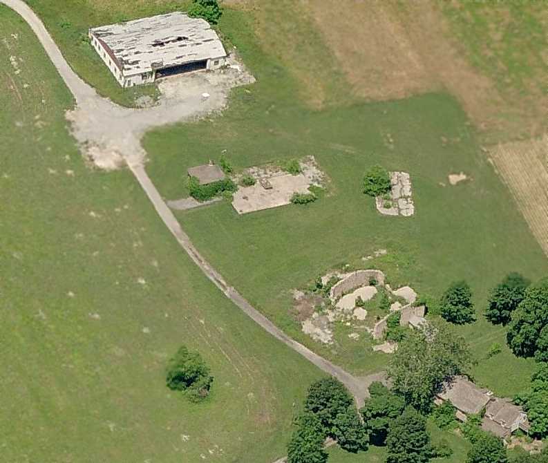
A 2016 aerial view looking northwest showed the site of Stoltzfus Field was no longer overtly recognizable as a former airfield, with the runway no longer distinct.
The foundations of the hangar & operations building remained, but the former repair shop had been replaced by more modern buildings.
Thanks to Jay Cooke for pointing out this airfield.
____________________________________________________
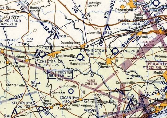
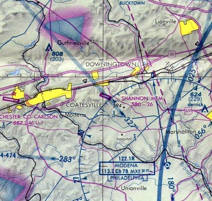
Downingtown Airport / Shannon Airport, Coatesville PA
39.98, -75.74 (West of Philadelphia, PA)
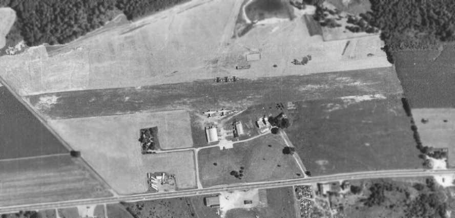
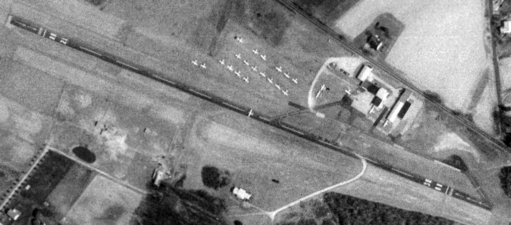
Downingtown Airport, as depicted on an 8/19/58 aerial view (from Penn Pilot).
A 1950 aerial view did not yet show any sign of an airfield at this location,
nor was any airfield depicted at this location on the 1953 USGS topo map.
According to former flight instructor Dan Kukjian, "Downingtown Airport began around 1954, and owner at that time was a man named Park Book.
It had been an airport with hangars & an office & 3 runways before the Shannon family purchased it."
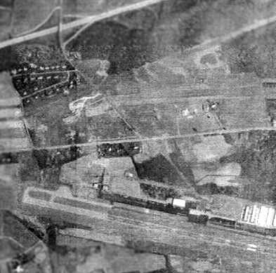
The earliest photo which has been located of Downingtown Airport was a 6/7/58 aerial view (from Penn Pilot).
It showed the field as having 2 (or 3) grass runways, with a few small hangars & 2 light aircraft along the north side.
However, no airport at this location was yet depicted on the September 1958 NY Sectional Chart.
The earliest aeronautical chart depiction of Downingtown Airport which has been located was on the January 1959 Washington Sectional Chart,
which depicted Downingtown Airport as having a mere 2,000' unpaved runway.
Downingtown Airport may gone through some period of closure during its change in ownership,
as the Aerodromes table on the 1960 Washington Sectional Chart chart included the remark, "Closed until further notice."
It was described as having 2 runways, with the longest being a 2,000' turf strip.
According to Dan Kukjian, Park Book sold Downingtown Airportto Bob Shannon Sr. at some point around 1960-61.
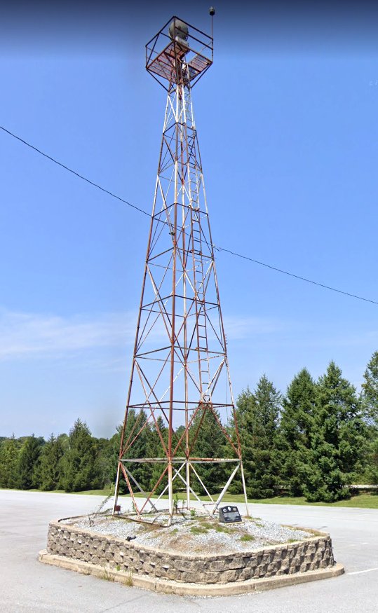
Bob Shannon purchased a former airway light beacon tower in 1961 which had been used by the airmail pilots in the 1920s,
and was located off of Route 10, near the town of Compass.
Bob Shannon bought the tower for $1, disassembled it, and trucked to the airport & reassembled it to serve as the airport beacon tower.
The 1963 New York Sectional Chart (according to Chris Kennedy) & 1964 Washington Sectional Chart (courtesy of John Voss)
described Downingtown Airport as having a single 3,160' turf runway.
Downingtown Airport was renamed in memorial to owner Bob Shannon after his passing.
It was labeled as Shannon Memorial Airport on the 1967 Washington Sectional Chart (courtesy of Mike Keefe).
The earliest topo map depiction hich has been located of Shannon Airport w was on the 1968 USGS topo map.
It depicted a single unpaved northwest/southeast runway, labeled as “Landing Strip”, with several buildings on the northeast side.
The 2 grass runways at Shannon had evidently been replaced by a significantly longer paved runway at some point between 1964-71, as shown on a 7/5/71 aerial view.
Over 16 light aircraft were visible on the field.
The 1975 SkyCharts Enroute Atlas (according to Timothy Aanderud) described Bob Shannon Memorial Field as having a single 2,600' hard-surface Runway 12/30.
The February 1975 Philadelphia Terminal Aeronautical Chart (courtesy of Mitchell Hymowitz) depicted Shannon Memorial as having a 2,600' paved runway.
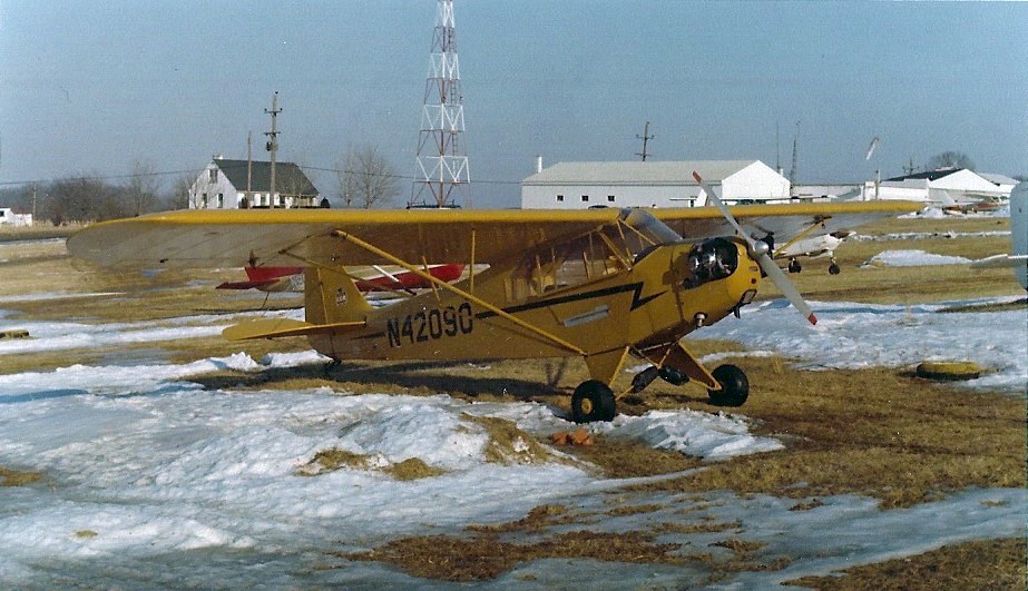
A 1975-77 photo by Ken Morrison of his Cub N42090 which he based at Shannon Airport, with the red & white beacon tower visible in the background.
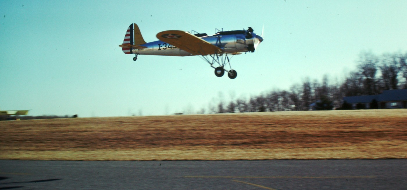
A 1975-77 photo by Ken Morrison of a beautiful polished-aluminum Ryan PT-22 Recruit owned by local pilot Thomas Macario overflying Shannon's runway.
Ken observed, “In the background is Bob Shannon's house.”
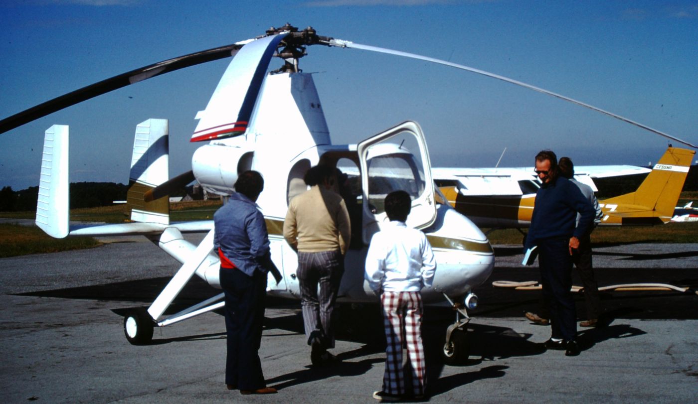
A 1975-77 photo by Ken Morrison of an Air & Space 18A auto-giro at Shannon Airport.
Ken recalled, ,”It was being leased by John Roach, wearing a sweeter with his hands on his hips.
John & I worked a pilots with Keystone Helicopter in West Chester; he was giving instruction in it & I took a ride to try it out.”
Josh Garfield recalled of Shannon Airport, "I took my first flying lesson at this airport on 12/18/76."
On the 1978 chart, Shannon Airport was described as having a paved 2,600' Runway 12/30, as well as shorter parallel turf strip.
The manager was listed as Robert Shannon Jr.
Larry Toto recalled, “I look back on my time at Oxford & Shannon Fields with fondness. I started my training at Oxford & ended with my private license at Shannon.
One incident at Shannon Memorial Field I do recall is when after getting my private license, I took up one passenger, then landed & switched to another passenger.
One passenger was my younger brother, Chris. My mistake was that I taxied up to the ramp and, without shutting down the engine, started swapping passengers. Big mistake!
Bob Shannon, who operated the field, came running out of the flight office slicing his hand across his throat in a motion that surely meant... Shutdown!
I knew immediately that simply swapping passengers with the engine running was a bad idea. Bob simply said ....NEVER do that....ALWAYS shutdown.
Lesson learned. I went on to become a CFII & that lesson has come up on occasion.”
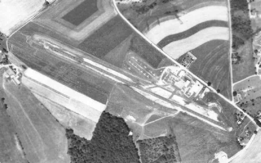
Shannon Airport, as depicted in the 1992 PA Airport Directory (courtesy of Timothy Aanerud).
At the time of the 1992 USGS aerial picture, Shannon Airport consisted of a single 3,000' paved runway
(which appeared recently resurfaced & painted), along with a group of small hangars north of the runway.
It appeared quite healthy - note the plane on the middle of runway & the large number of planes parked along north side of field.
The last aeronautical chart depiction which has been located of Shannon Airport was on the March 1993 Washington Sectional Chart (courtesy of Mike Keefe).
It depicted Shannon as having a 2,600' paved northwest/southeast runway.
Unfortunately, Shannon was closed sometime between 1993-94.
According to a local resident, the airport closed due to disagreements among the brothers & sister who owned the field.
According to New Garden Aviation, “Shannon Airport was lost due to family turmoil.”
Shannon Airport was depicted as “Closed” on the March 1994 Washington Sectional Chart (courtesy of Ron Plante).
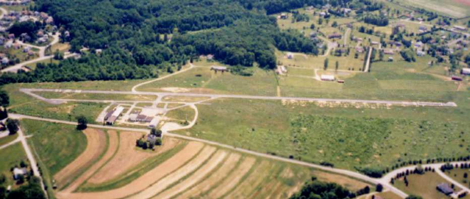
A 1998 aerial picture by Philip K looking south at Shannon Airport (after it was closed, but before it was redeveloped).
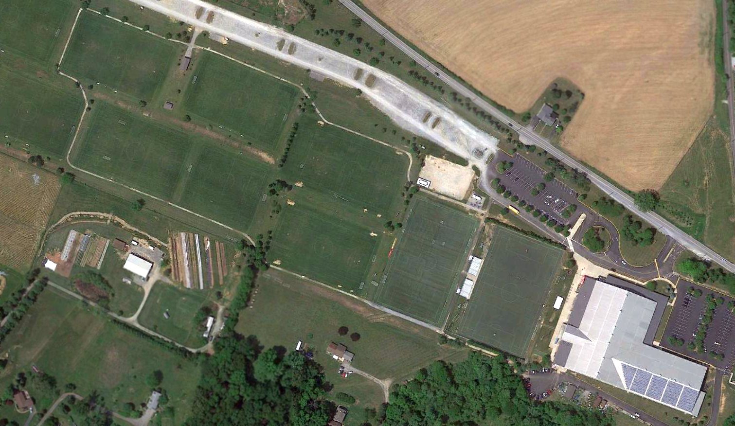
The Shannon Airport property was redeveloped with athletic fields at some point between 1998-99,
as a 1999 aerial photo showed no trace remaining of the former airport.
A 2001 photo by Jay Cooke of what has become of the site of the former Shannon Airport - an athletic complex.
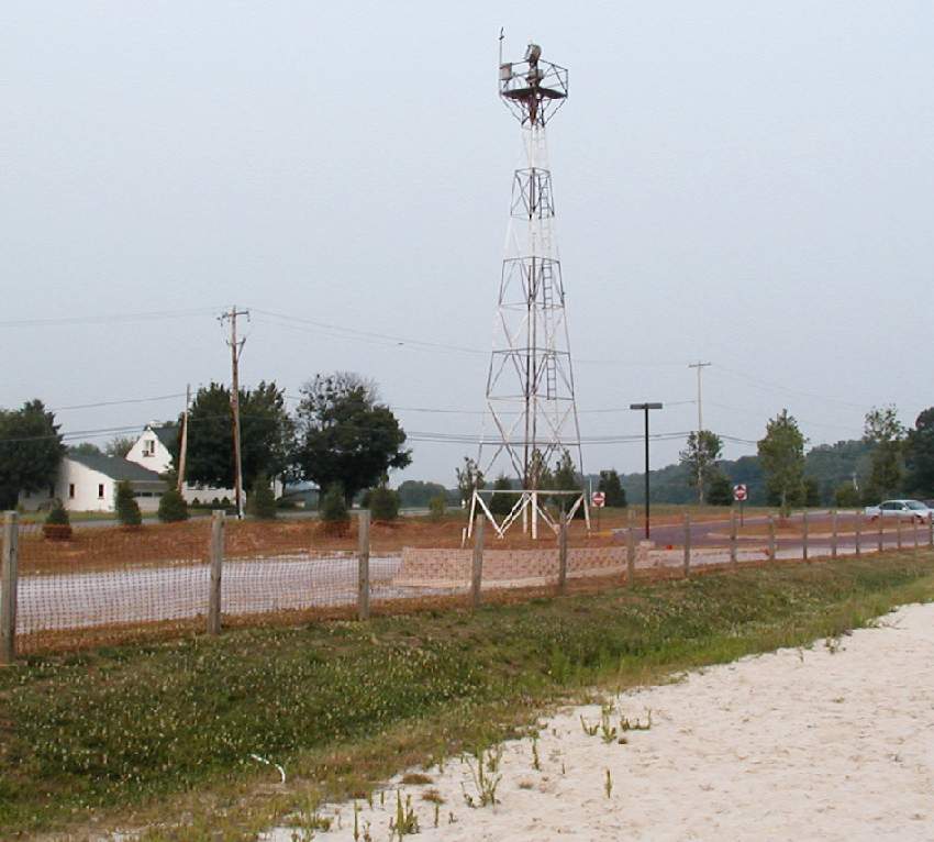
A 2001 photo by Jay Cooke of the former Shannon Airport beacon light tower,
which remains standing in the middle of what is now a parking lot for the athletic fields.
According to Jay Cooke, who visited the site in 2001, the property has been redeveloped as an athletic complex.
In an ironic twist, the rotating beacon light tower still remains all by itself - it now stands in the middle of a parking lot.
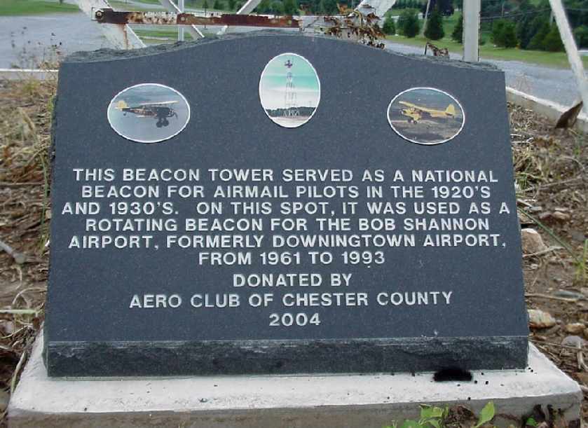
A 2004 photo by Rick Davis of a granite plaque on the former Shannon beacon tower
which will be dedicated on 9/25/04 by The Aero Club of Chester County.
A 2016 aerial view showed no trace remains of Shannon Airport.
An August 2021 photo looking northwest at the former Shannon Airport beacon light tower,
which remains standing in the middle of what is now a parking lot for the athletic fields, with the memorial plaque at its base.
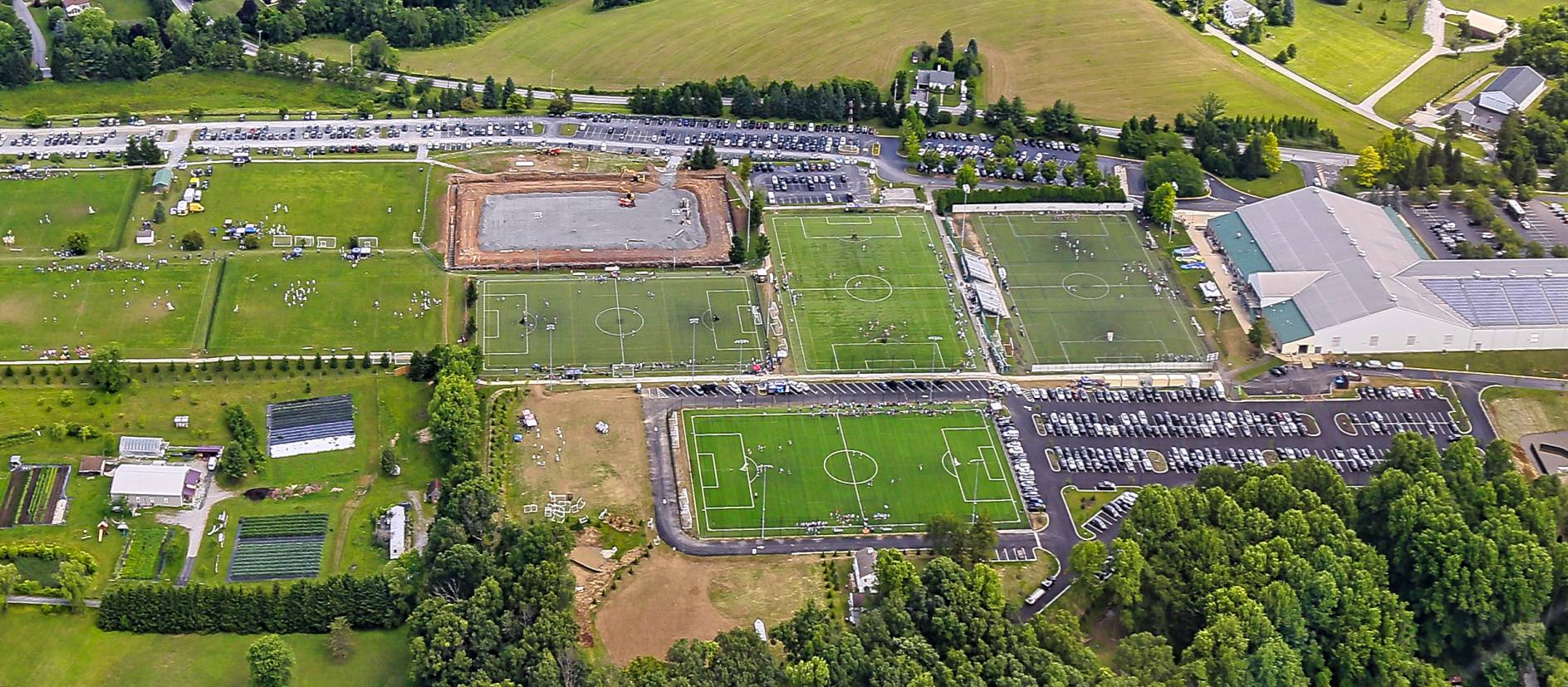
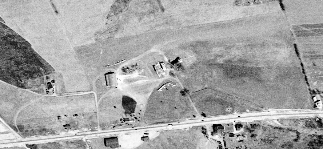
A 6/26/23 aerial view by Ed Figuli looking northeast at Shannon Airport site.
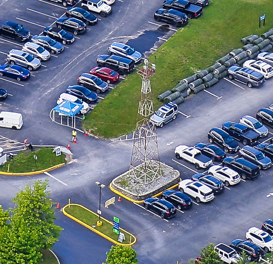
A 6/26/23 aerial view by Ed Figuli looking south of the former Shannon Airport beacon tower.
____________________________________________________
Since this site was first put on the web in 1999, its popularity has grown tremendously.
If the total quantity of material on this site is to continue to grow,
it will require ever-increasing funding to pay its expenses.
Therefore, I request financial contributions from site visitors,
to help defray the increasing costs of the site
and ensure that it continues to be available & to grow.
What would you pay for a good aviation magazine, or a good aviation book?
Please consider a donation of an equivalent amount, at the least.
This site is not supported by commercial advertising –
it is purely supported by donations.
If you enjoy the site, and would like to make a financial contribution,
you
may use a credit card via
![]() :
:
Please consider checking the box to make a monthly donatation.
For a mailing address to send a check, please contact me at: paulandterryfreeman@gmail.com
If you enjoy this web site, please support it with a financial contribution.
please contact me at: paulandterryfreeman@gmail.com
If you enjoy this web site, please support it with a financial contribution.
____________________________________________________
This site covers airfields in all 50 states.