Abandoned & Little-Known Airfields:
Northeastern Nebraska
© 2002, © 2024 by Paul Freeman. Revised 4/23/24.
____________________________________________________
Please consider a financial contribution to support the continued growth & operation of this site.
Ak-Sar-Ben Field (revised 4/23/24) - Arrow Airport (revised 11/10/21) - Blair Airport (revised 11/10/21) - Clear Ridge Airport (revised 6/2/18)
Harm Ranch Airfield (revised 11/13/20) - South Omaha Airport (revised 5/6/18) - Union Airport (revised 3/11/23) - Weibe Airfield (added 10/12/22)
____________________________________________________
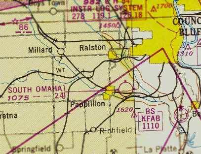
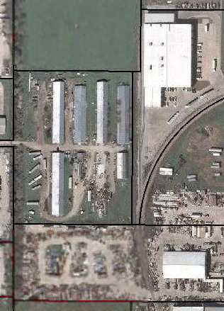
41.232, -96.18 (West of Downtown Omaha, NE)
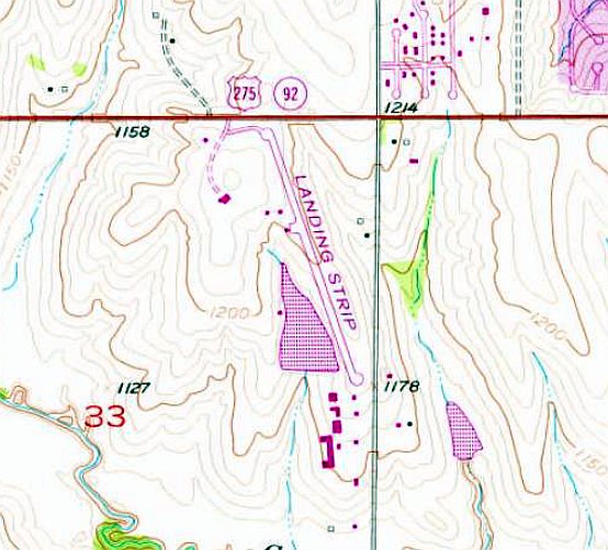
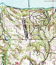
Weibe Airfield, as depicted on the 1975 USGS topo map.
No airfield was yet depicted at this location on a 1955 aerial picture.
According to Matt Feilmeier, “This private airstrip was owned by John Weibe. I used to drive by it as a kid.”
The earliest depiction which has been located of Weibe Airfield was on a 1966 aerial photo,
which depicted a single unpaved northwest/southeast runway, with a single small hangar on the west side.
A 1969 aerial view continued to depict Weibe Airfield with an unpaved runway.
Weibe Airfield was not depicted at all on 1971/93/94/99 Omaha Sectional Charts.
Weibe Airfield gained a paved runway at some point between 1969-75,
as the 1975 USGS topo map depicted a single paved northwest/southeast runway, generically labeled “Landing Strip”,
with a ramp & a small building on the west side.
A 1981 aerial photo depicted Weibe Airfield as having a single paved northwest/southeast runway,
and a 2nd hangar had been added at some point between 1975-81 on the southeast side.
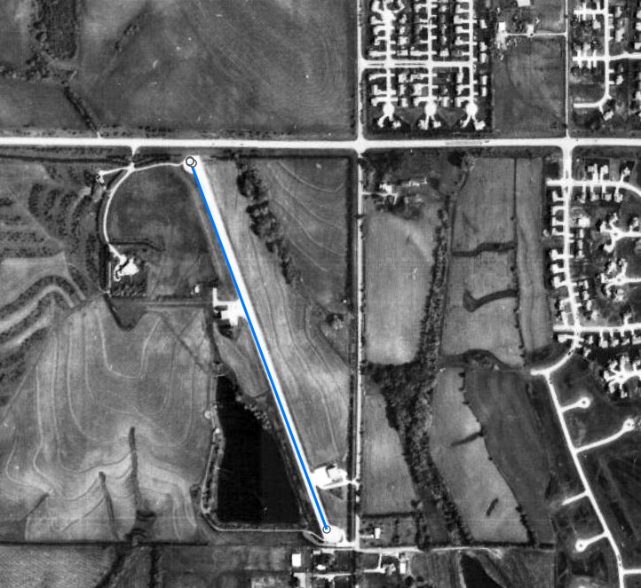
A 1982 aerial photo (courtesy of Matt Feilmeier) depicted Weibe Airfield as having a single paved northwest/southeast runway & 2 hangars.
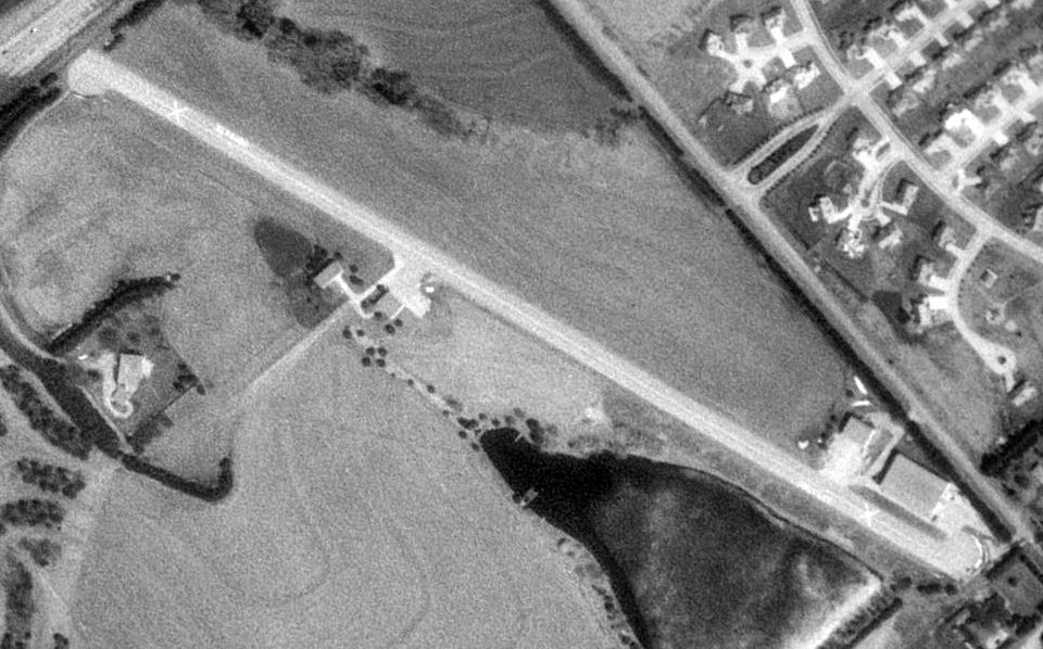
A 1993 aerial view looking northeast showed Weibe Airfield had gained a 3rd hangar on the southeast corner.
A 1998 aerial photo (courtesy of Matt Feilmeier) showed Weibe Airfield's runway pavement had been removed at some point between 1993-98, probably due to future redevelopment.
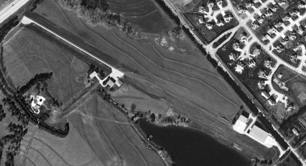
A 1999 aerial view looking northeast showed Weibe Airfield's runway pavement had been removed, but the 3 hangars still remained.
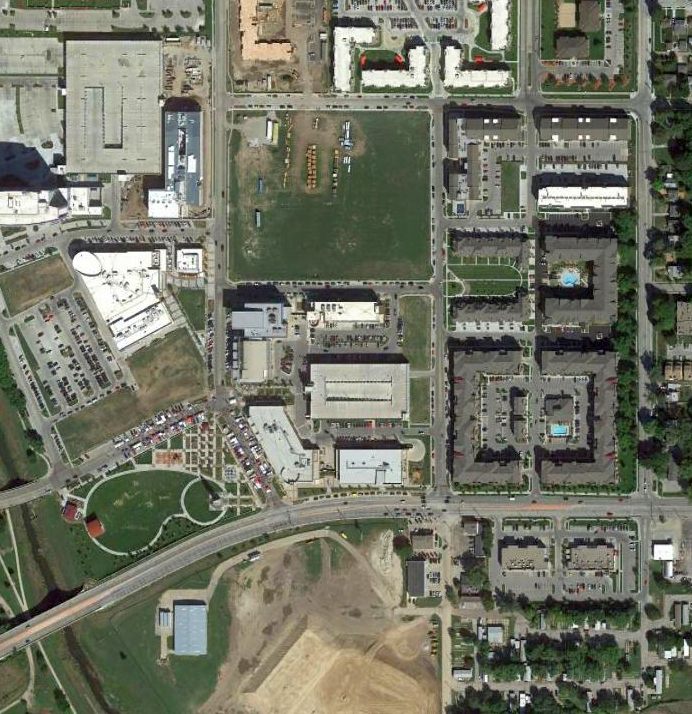
A 2001 aerial photo (courtesy of Matt Feilmeier) showed all traces of Weibe Airfield had been removed, including the 3 former hangars.
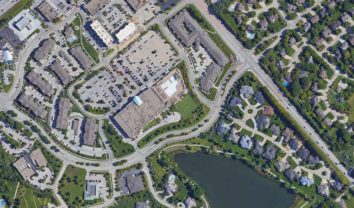
A 2019 aerial view looking northeast shows no trace remaining of Weibe Airfield, with shopping & housing covering the site.
Thanks to Matt Feilmeier for pointing out this airfield.
____________________________________________________
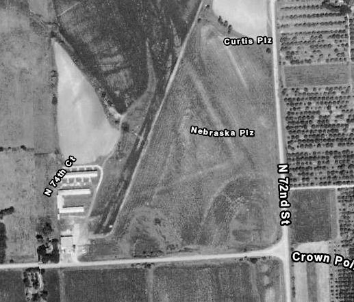
Clear Ridge Airport, Omaha, NE
41.316, -96.026 (Northwest of Downtown Omaha, NE)
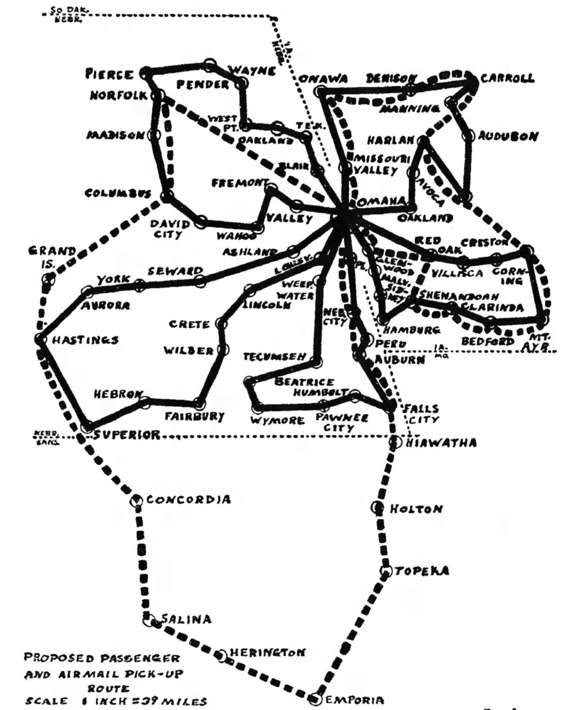
A 1944 map of the proposed routes of Clear Ridge Aviation (Mike McDonald).
According to a 1944 article (courtesy of Mike McDonald), Clear Ridge Aviation, Inc. of Omaha was formed in 1944
to provide passenger, mail and package air service in eastern Nebraska, western Iowa and part of Kansas.
The article notes it acquired land to build its own airport, which became Clear Ridge Airport.
But the Civil Aeronautics Board authorized the Iowa Airplane Company to provide service instead, and Clear Ridge Aviation appealed.
According to a May/June 1944 issue Cornhusker CAP News,” (courtesy of Mike McDonald),
Three of the airport owners, Fraser, Mueller and Cooke were active in the Civil Air Patrol.
Clear Ridge Airport was not yet depicted on the August 1944 Lincoln Sectional Chart.
The earliest aeronautical chart depiction which has been located of Clear Ridge Airport was on the March 1945 Lincoln Sectional Chart.
It depicted Clear Ridge as a commercial/municipal airport.
An advertisement for Clear Ridge Aviation from the 2/26/46 Omaha Benson High School newspaper (courtesy of Mike McDonald).
According to a 1944 article (courtesy of Mike McDonald), Clear Ridge Aviation's appeal of the Civil Aeronautics Board's denial of their service application dragged out to 1948,
with their appeal eventually rejected.
A 1948-49 USAF Target Complex Chart (courtesy of Mike McDonald) depicted Clear Ridge Airport as having 2 runways.
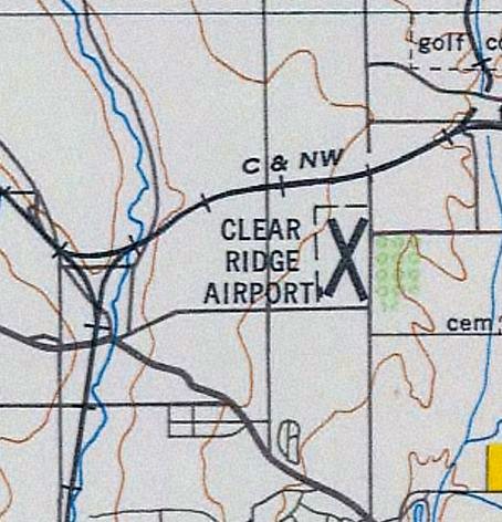
The last aeronautical chart depiction which has been located of Clear Ridge Airport was on the June 1955 Lincoln Sectional Chart.
It depicted Clear Ridge as having a 2,800' unpaved runway.
A 1955 aerial photo (from the Omaha-Douglas County GIS, via Mike McDonald) depicted Clear Ridge Airport as having 2 unpaved runways,
measuring 2,200' southwest/northeast & 1,850' northwest/southeast.
A cluster of hangars & a few light aircraft were at the southwest corner.
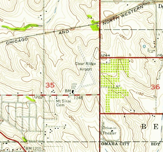
The 1956 USGS topo map (courtesy of Mike McDonald) depicted Clear Ridge Airport as having 2 unpaved runways, and a set of buildings at the southwest corner.
According to a 5/14/56 article (courtesy of Mike McDonald), Clear Ridge Airport sustained damage after a night of severe weather.
An advertisement in the August 1959 Flying Magazine solicited a new operator for Clear Ridge Airport, perhaps indicating its decline of business.
A series of 1960 articles (courtesy of Mike McDonald) described rezoning of the area of Clear Ridge Airport,
so that it could be sold for industrial manufacturing, less than 6 months after the notice looking for an operator for the airport.
Clear Ridge Airport stayed in business until 1960 when the owners sold it for industrial development.
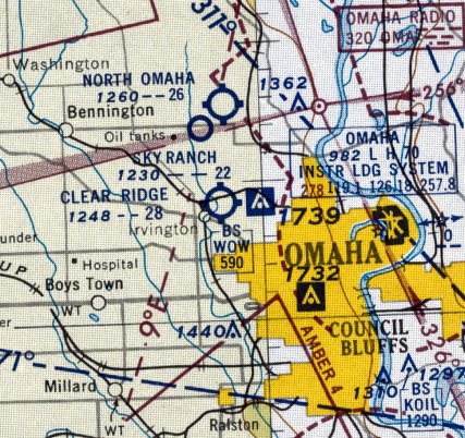
Clear Ridge Airport was no longer depicted on the May 1960 Lincoln Sectional Chart.
A 1962 aerial photo (from the Omaha-Douglas County GIS, via Mike McDonald) showed that Clear Ridge Airport's runways were disappearing,
although the airport buildings remained at the southwest corner.
A 1966 aerial photo showed that Clear Ridge Airport's northeast/southwest runway was further deteriorated,
but the airport buildings remained at the southwest corner.
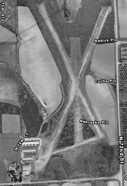
According to articles (courtesy of Mike McDonald), a Vickers plant was built on the site of Clear Ridge Airport.
The plant was over 400,000 square feet & said to be the largest hydraulic valve & component manufacturing facility in the world.
The Vickers plant on the site of Clear Ridge Airport closed in 2001.
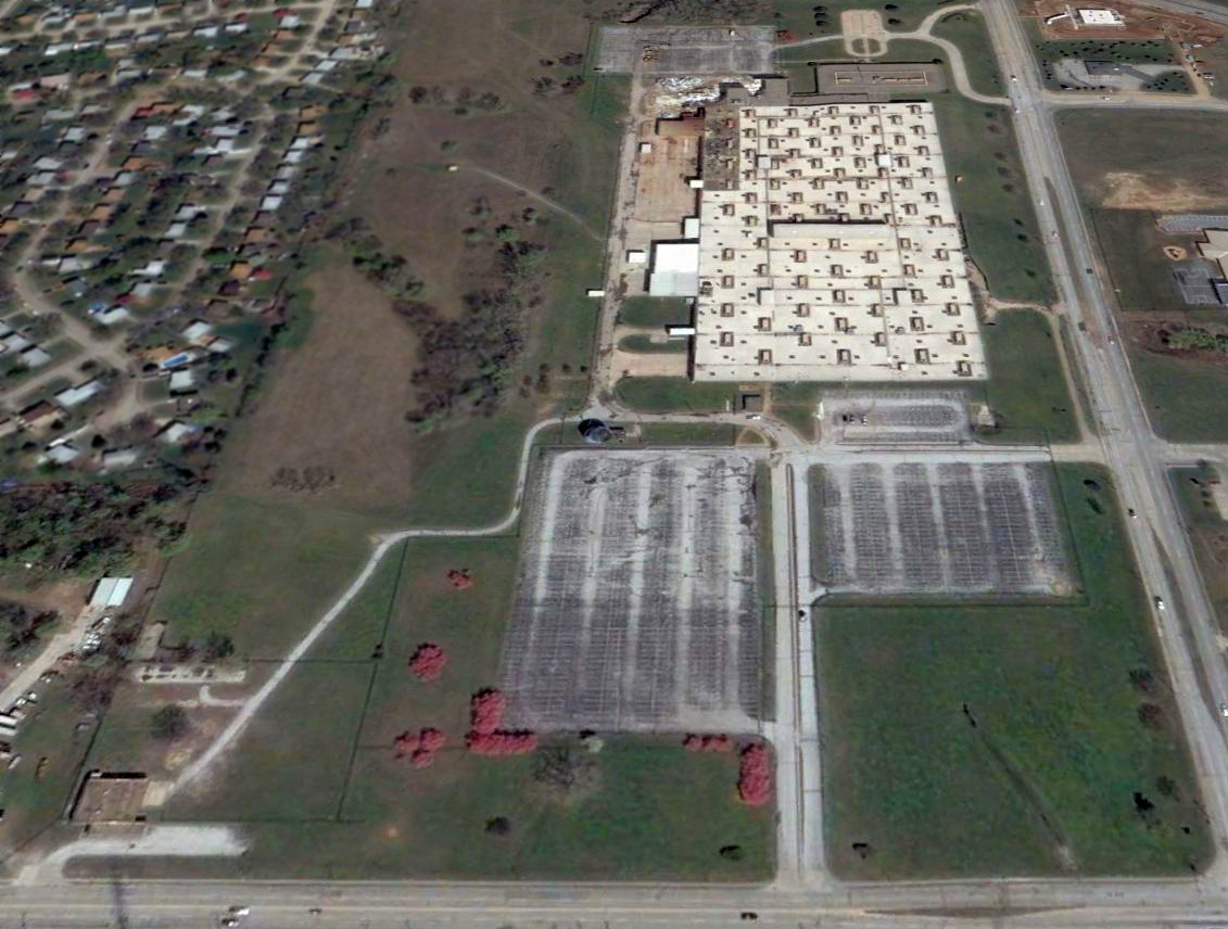
The last photo which has been located showing any remnants of Clear Ridge Airport was a 2005 aerial view looking north.
One airport building still remained standing at the very southwest corner of the airport site, and the foundations of other airport buildings were still recognizable.
The former Vickers plant remained standing over the majority of the airport site.
Later in 2005 a shopping center was built on the site, replacing the former Vickers plant & the last remnants of Clear Ridge Airport.
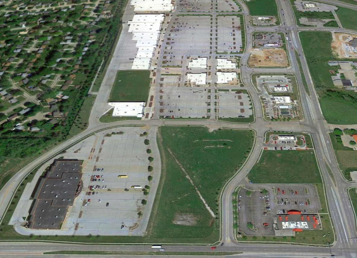
A 2016 aerial view looking north shows no trace remaining of Clear Ridge Airport, with a shopping center covering the airport site.
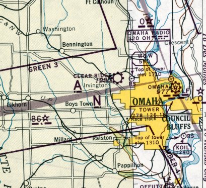
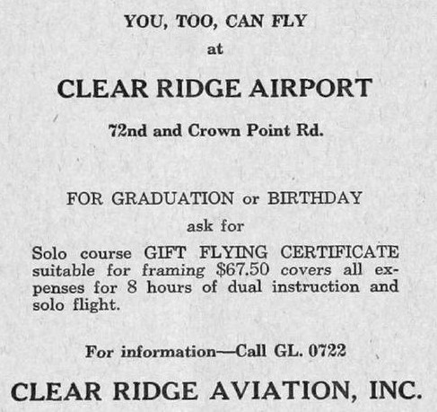
The site of Clear Ridge Airport is located northwest of the intersection of North 72nd Street & Crown Point Avenue.
Thanks to Mike McDonald for pointing out this airfield.
____________________________________________________
41.24, -96.01 (Southwest of Downtown Omaha, NE)
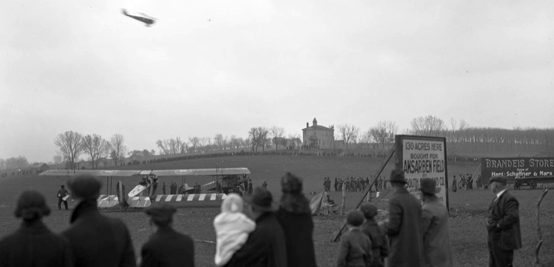
A 4/28/19 airshow held at the site of the eventual Aksarben Field (Mike McDonald).
According to Mike McDonald, “The original airmail field in Omaha was Ak-Sar-Ben Field, developed by the Chamber of Commerce to entice the air mail service to come to Omaha.
In 1919, Ak-Sar-Ben (Nebraska spelled backwards), a philanthropic group of business leaders, bought the old state fairgrounds property on the southwest fringes of Omaha.
About this same time, Omaha was being considered as a stop on the transcontinental air mail route.
The Omaha Chamber of Commerce Aerial Transportation Committee (some of its members were probably members of the Knights of Ak-Sar-Ben),
leased part of the Ak-Sar-Ben property for the air mail landing field.
In 1920 the Committee raised funds & built a hangar to be used for air mail in the southeast corner of the field at a cost of $36,000.”
A 1921 aerial view looking northwest at a hangar & 2 planes at Aksarben Field (Mike McDonald).

The location of Ak-Sar-Ben Field, as depicted on the 5/1/23 Commerce Department Airway Bulletin (courtesy of Mike Denja).

The 5/1/23 Commerce Department Airway Bulletin (courtesy of Mike Denja) described Ak-Sar-Ben Field as a government airfield operated by the Air Mail Service.
It was depicted as a rectangular loam soil field measuring 1,400' east/west, with an Air Mail hangar on the southeast corner.
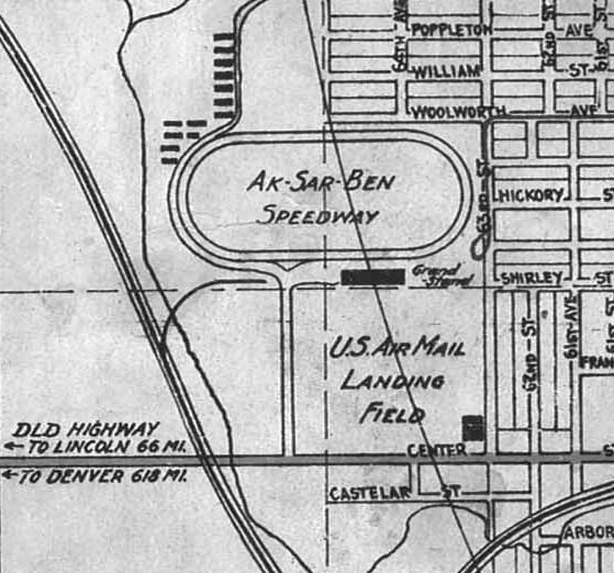
A 1923 map showing the “U.S. Air Mail Landing Field” adjacent to Al-Sar-Ben Speedway (Mike McDonald).
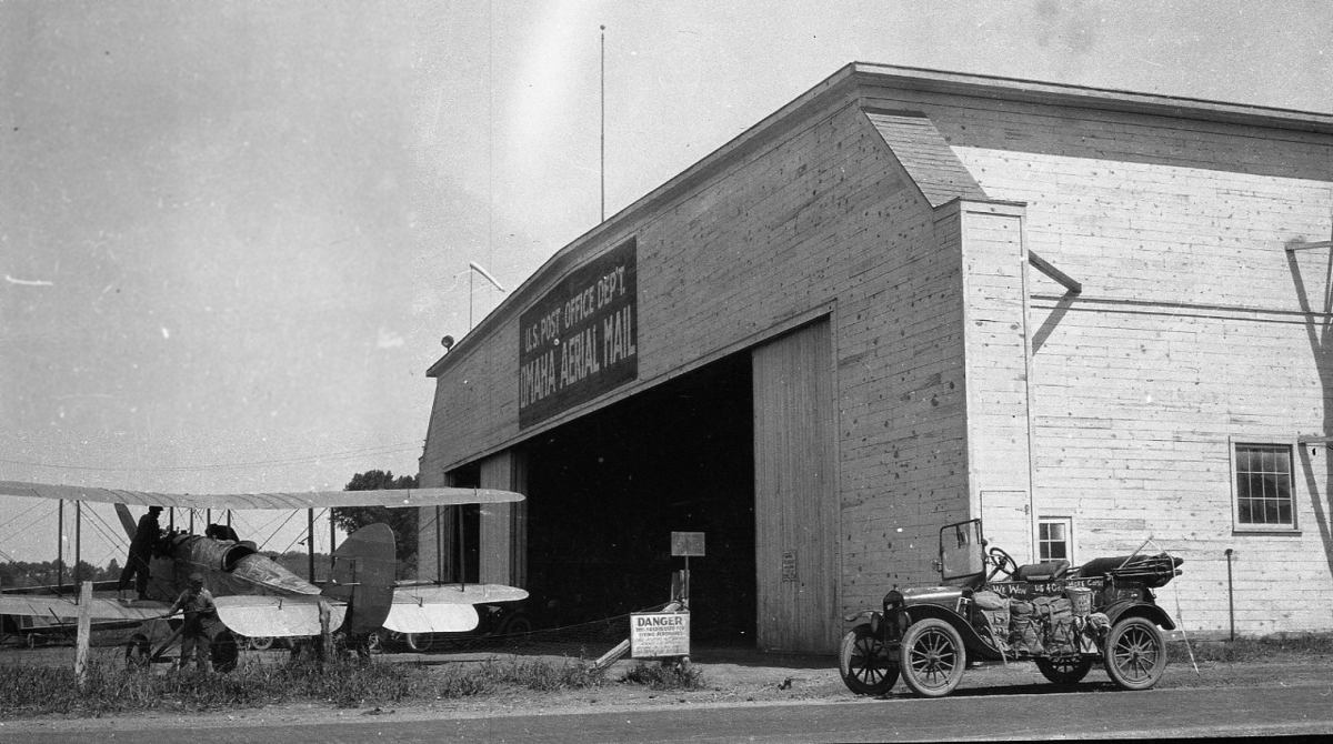
A 1923 photo of an unidentified biplane in front of a hangar marked “U.S. Post Office Dep't. Omaha Aerial Mail” at Aksarben Field (Mike McDonald).
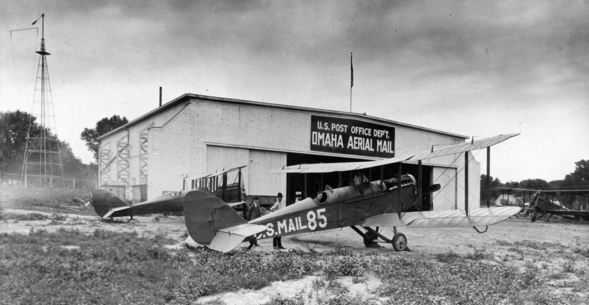
Another circa 1920s photo of 3 unidentified biplanes in front of a hangar marked “U.S. Post Office Dep't. Omaha Aerial Mail” at Aksarben Field (Mike McDonald).
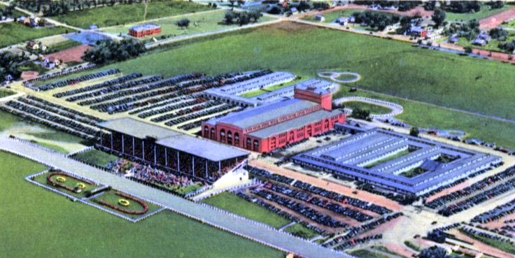
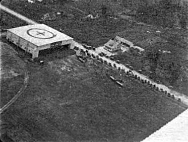
A circa 1920s postcard aerial image looking southeast at Ak-Sar-Ben Field adjacent to Al-Sar-Ben Speedway (Mike McDonald).
According to Mike McDonald, “The Chamber also had hopes of developing it into a municipal airport & a non-mail operator set up there.
However, when the Post Office decided to fly full-time night air mail, it determined Ak-Sar-Ben wasn't suitable & moved all air mail service to Fort Crook in 1924.
Call it fate, bad luck, good luck or whatever, but 10 days before the official start at Fort Crook, a tornado hit the Ak-Sar-Ben site,
destroying or damaging most of the planes & tearing off part of the roof.
The site was abandoned & taken over by the Ak-Sar-Ben race track, from which the Chamber originally bought the land.”
Ak-Sar-Ben Field was no longer depicted on the June 1935 Lincoln Sectional Chart.
“Ak-Sar-Ben Field” was still depicted on a 1938 street map (courtesy of Kevin Walsh),
even though it had evidently ceased to operate more than a decade prior.
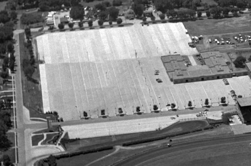
A circa late 1950s aerial view looking southwest at the site of Ak-Sar-Ben Field, paved over as a parking lot (Mike McDonald).
According to Mike McDonald, “The track closed in the late 1990s & the area was developed into a mixed residential-commercial site.”
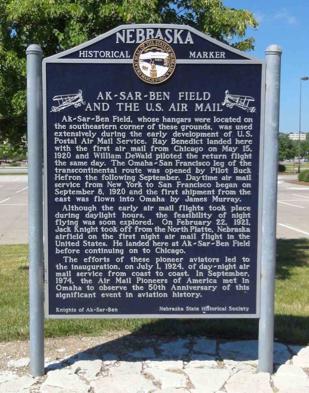
A 2013 photo of a historical marker commemorating the site of Ak-Sar-Ben Field.
Mike McDonald reported, “If one knows where to look, there is an historical marker placed by the NE State Historical Society, but it's not where the airfield was.”
A 2013 aerial view shows no trace remaining of Ak-Sar-Ben Field.
The site of Ak-Sar-Ben Field is located at the intersection of South 67th Street & Frances Street.
____________________________________________________
Harm Ranch Airfield (NE34), Lindy, NE
42.81, -97.725 (Northwest of Omaha, NE)
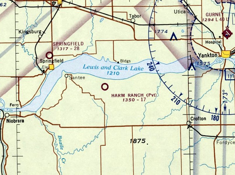
Harm Ranch Airfield, as depicted on the November 1966 Sioux City Sectional Chart.
This airfield was evidently established at some point in 1966,
as it was not yet depicted on the May 1966 Sioux City Sectional Chart.
The earliest depiction which has been located of the Harm Ranch Airfield was on the November 1966 Sioux City Sectional Chart.
It depicted Harm Ranch as a private airfield having a mere 1,700' unpaved runway.
Harm Ranch Airfield was listed in the 1967 AOPA Airport Directory (according to Chris Kennedy).
According to Drew Lange, “There is an area northwest of Crofton overlooking Lewis & Clark Lake known as the Devil's Nest.
A company in the early 1970s attempted to develop the land into an upper-class residential area
with attractions such as an equestrian club, golf course, yacht club, and even a ski area.
A sod landing strip was used to fly in some big-name celebrities for publicity.
Although all the attractions were built, few houses were ever built & the company went bankrupt.”

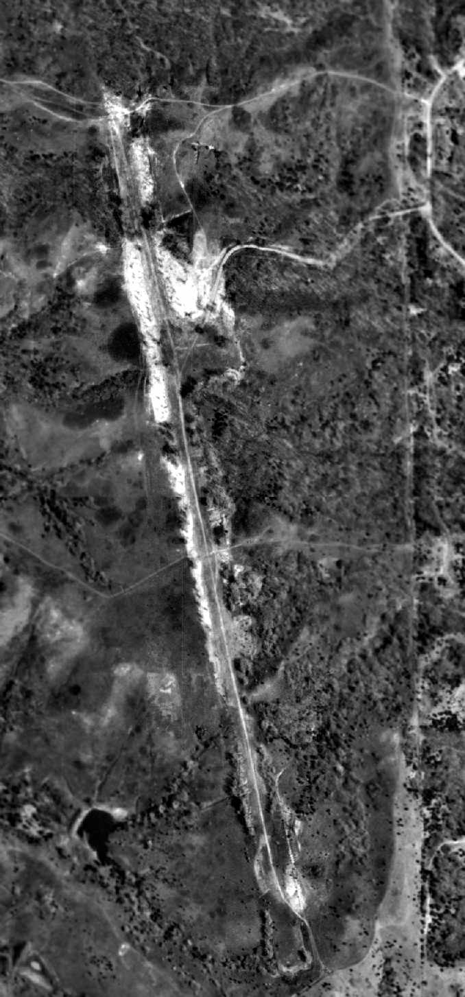
The earliest photo which has been located of the Harm Ranch Airfield was a 4/22/73 USGS aerial photo,
which depicted a very rough unpaved northwest/southeast runway, with no buildings or other improvements.
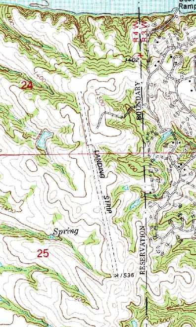
The 1974 USGS topo map depicted Harm Ranch as having a single unpaved north/south unpaved runway, labeled simply as “Landing Strip”.
The last aeronautical chart depiction which has been located of the Harm Ranch Airfield was on the September 1975 Omaha Sectional Chart (courtesy of Chris Kennedy).
It depicted Harm Ranch as a private airfield having a mere 1,300' unpaved runway.
According to Drew Lange, “Robert Harm was the owner of the land west of the line that says 'Santee Indian Reservation'.
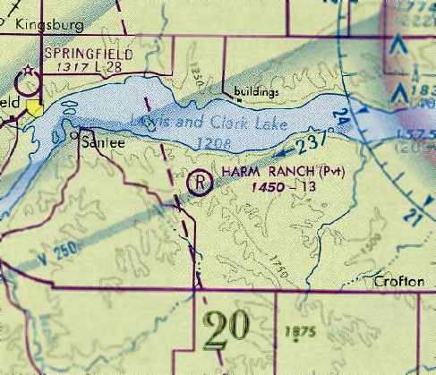
The 1982 AOPA Airports USA Airport Directory (courtesy of Chris Kennedy)
described Harm Ranch as a private airfield having 2 turf runways: 1,700' Runway 16/34 & 1,320' Runway 14/32.
The notes included “Advise experienced pilots only.”
The airfield was labeled as “Harm Ranch” on the 1980 USGS topo map.
The 1984 USGS topo map depicted the “Landing Strip” as having a single north/south runway.
The Harm Ranch Airfield was evidently abandoned at some point between 1982-97,
as it was no longer depicted at all on the February 1997 Omaha Sectional Chart (according to Chris Kennedy).
The 1999 USGS aerial photo depicted Harm Ranch Airfield's single north/south unpaved runway, remaining largely intact.
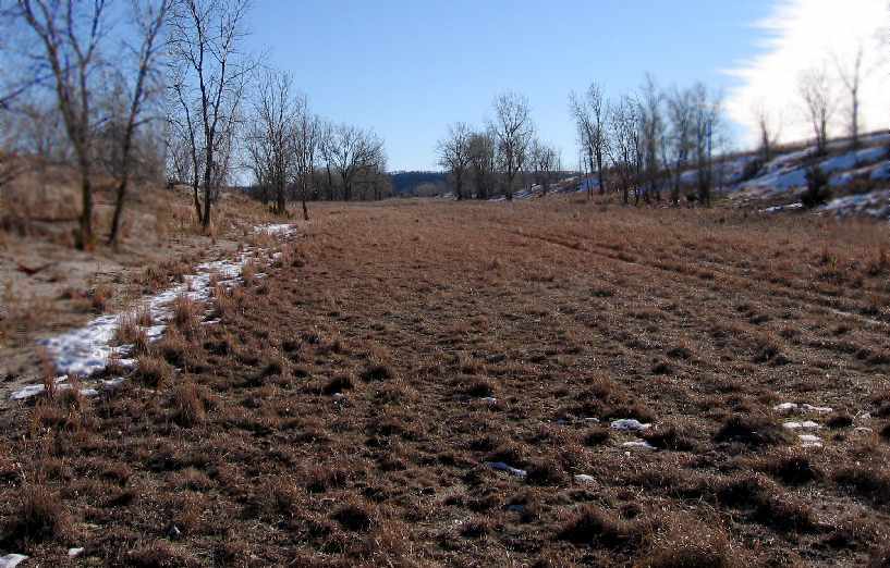
A 2006 photo of the middle of the former Harm Ranch Airfield by Drew Lange.
Drew Lange reported in 2006 of the former Devil's Nest development, “Now all the 'attractions' sit vacant
and the few houses that are there are used as summer cabins.
There isn't much left, especially at the airstrip - it just looks like a dirt road now.”
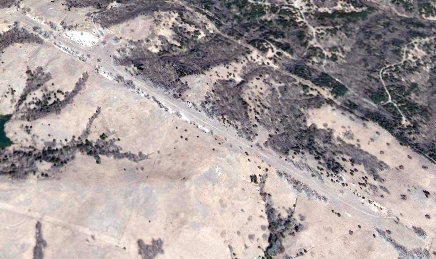
A 2015 aerial view looking northeast shows the Harm Ranch Airfield runway remains recognizable.
The site of the Harm Ranch Airfield is located at the western terminus of 895 Road, West of 540 Avenue.
____________________________________________________
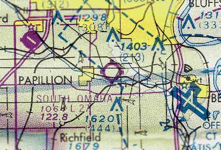
South Omaha Airport, Papillion, NE
41.16, -96.01 (Southwest of Omaha, NE)
South Omaha Airport, as depicted on the November 1948 Lincoln Sectional Chart (courtesy of Chris Kennedy).
This small general aviation airport was evidently established at some point between 1946-48
(like hundreds of other general aviation fields across the U.S.),
as it was not yet depicted on the December 1946 Lincoln Sectional Chart.
The earliest depiction of South Omaha Airport which has been located was on the September 1948 Lincoln Sectional Chart (courtesy of Chris Kennedy).
It depicted the field as having a 2,400' unpaved runway.
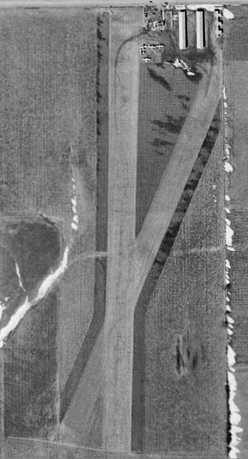
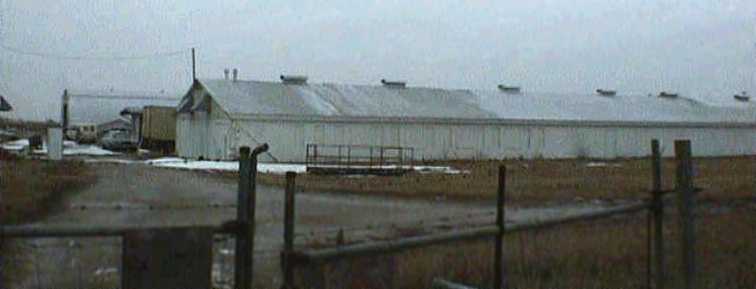
The earliest photo which has been located of South Omaha Airport was a 5/1/52 USGS aerial view.
It depicted the field as having 2 turf runways, with 5 single-engine aircraft & 5 hangars on the northeast corner of the field.
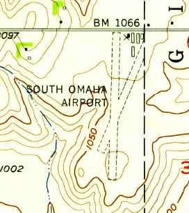
The 1956 USGS topo map depicted South Omaha Airport as having 2 turf runways, and 5 buildings on the northeast side.
David Gurkin provided details about 2 B-25 Mitchell bombers which sat at South Omaha Airport for years:
“The B-25s arrived at South Omaha airport in 1959 with the intent to be converted to tankers.
Due to unknown circumstances, they sat untouched for several years.
I can't remember the company name or the individuals who purchased the planes, but they were known as 'The B-25 King'.”
Cole Weidenbusch recalled, “I lived in Papillion from 1959-61.
My friend Harold Jones & I would do any kind of summer job we could find to earn some money,
then ride our bicycles out unpaved Cornhusker Road to the airport.
Somebody had a Waco open cockpit biplane, probably a UPF-7, that seated 2 in the front cockpit.
We would each pay the pilot $2.50 for a 1/2 hour ride!”
Cole continued, “We also asked for & got permission to crawl all around the TB-25Js, perhaps because we were 'paying' customers.
I remember 3 of them, one of which had an upgraded 'soundproofed' interior in the waist section since it was used for VIP travel.
All had bomb-bay tanks, but only one was outfitted with spray bars under the wings.
They had been bought to be used as crop sprayers,
but the owner(s) later came to the realization that they didn't have the performance to take off from South Omaha with a full load.
They were still sitting there deteriorating when I moved away.”
Cole continued, “The LeMay Aero Club has photos of planes from the former SAC Aero Club
(founded in 1950 by General Curtis E. LeMay) being flown from South Omaha.
Apparently, student pilots were only allowed to fly with their instructors from South Omaha until they got their certificates,
at which point they could fly from Offutt AFB after being checked out & cleared.
One of the planes pictured is a Cabin Waco which was reputed to have been owned by LeMay.”
Cole continued, “Sam Brown learned to fly there from the FBO. He was my instrument student years later.
His private pilot CFI was an old gentleman who kept a Fairchild 24W there.”
David Homan recalled of South Omaha Airport, “I used to live almost due North, on 48th & Harrison from 1960 (as a 1st grader).
In about 1960, my parents & mother's parents & I (an only kid) saw a high-wing taildragger land southbound, and proceeded to noseover to an abrupt stop.
I think there were 2 occupants, and I don't recall if they were just shookup or what.
In the mid-1960s, a friend or two of mine would visit the airport on our bikes. It soon became clear that the bombers were off-limits.
So, more than once, we snuck on board, and I thought there were 2 different types of aircraft, but really just remember the B-25 as one of them for sure.
I know that at least one of the aircraft, maybe both, had large tanks of some kind, that we eventually heard were for cropdusting.
I never heard for certain if they were actually used for that, but the tank(s) were definitely installed in the bomb-bay area.”
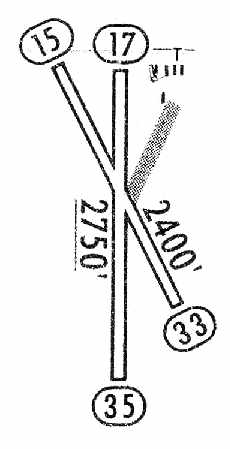
The 1965 Jeppesen Airway Manual (courtesy of Chris Kennedy)
depicted South Omaha Airport as having 2 turf runways: 2,750' Runway 17/35 & 2,400' Runway 15/33.
A cluster of 5 buildings was depicted on the northeast corner of the field. The manager was listed as Richard Whitted.
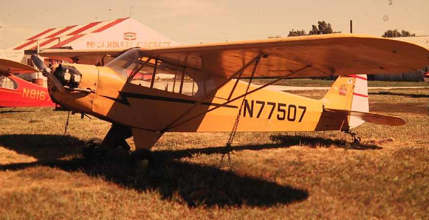
A 1971 photo by Nelson Carpenter of a Piper Cub at South Omaha Airport.
The McCandless Aircraft Fixed Base Operator is visible in the left background, with the T-hangars in the right background.
According to Nelson, “The Cub was the local trainer belonging to Harry McCandless who was the FBO.
He relocated from the former Council Bluffs Airport [in IA].”
The March 1977 Omaha Sectional Chart (courtesy of Chris Kennedy) depicted South Omaha Airport as having a 2,700' unpaved runway.
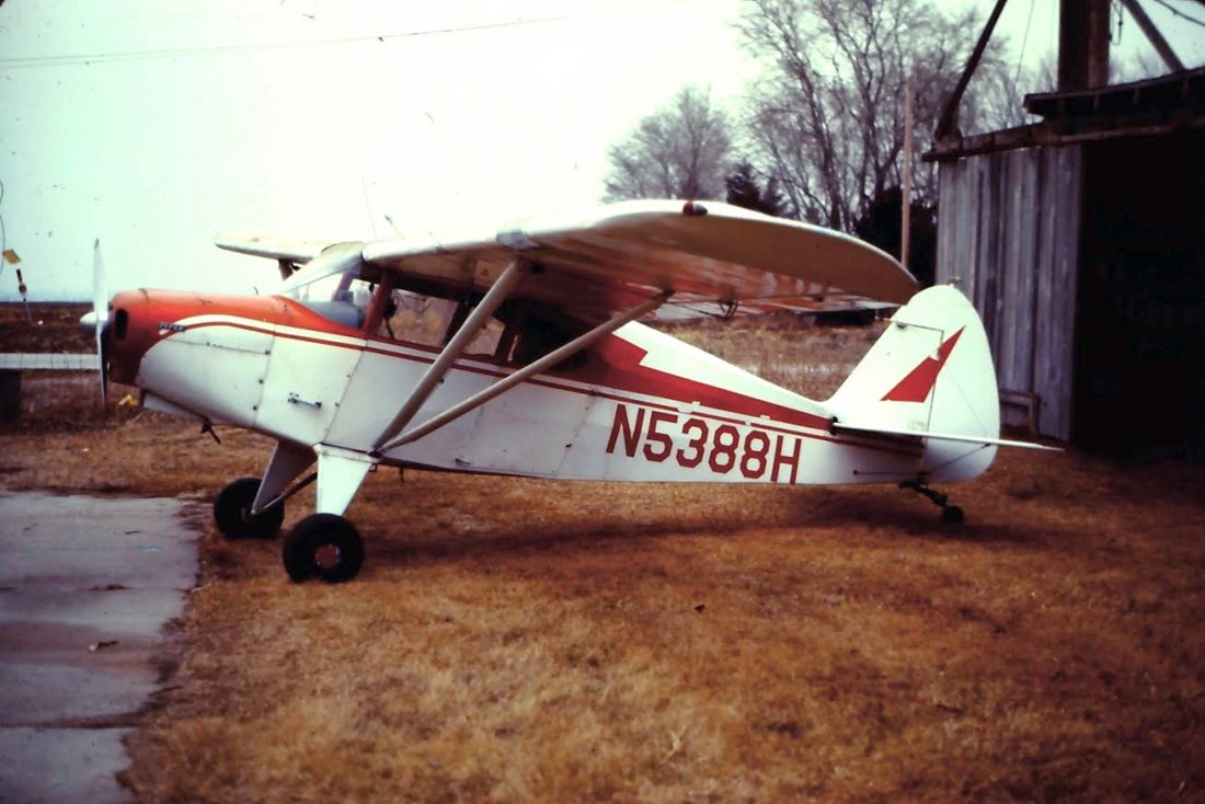
A 1980 photo by Brian Ramsey looking north at his Piper PA16 parked in one of South Omaha Airport's old hangers.
Brian recalled, “My PA16 was based at So Omaha until about 1982.
There were 3 runways, if you look at the topo map you can see the short one which I only used once with about a 40 knot headwind.”
According to Nelson Carpenter, “Two B-25 bombers had sat idle along the edge of the airfield for years.
The original owner of the bombers was going to convert them into tankers for fighting forest fires.
That never matured. The planes were sold to a movie company that retrofitted new engines
and made them airworthy for flying off the sod field.”
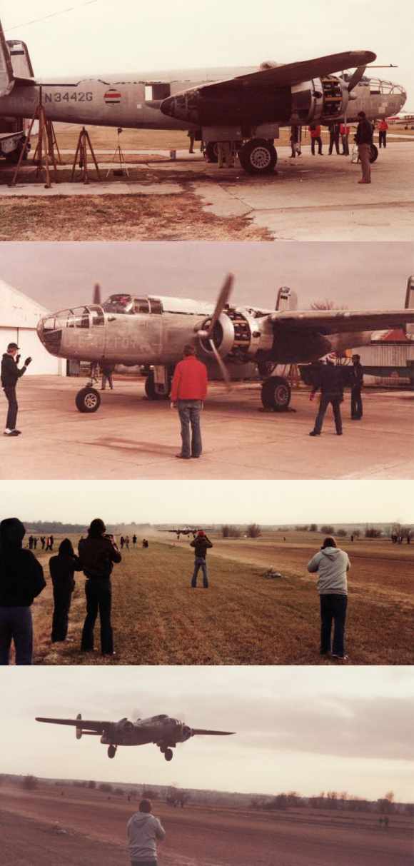
A series of photos by David Gurkin showing B-25 N3442G departing South Omaha Airport on 11/16/80.
David Gurkin provided additional details about the B-25s at South Omaha Airport:
“My brother was stationed at Offutt AFB in the early 1980s.
I was visiting with him in November 1980 when one of his friends mentioned there are 2 B-25s at South Omaha Airport
being readied for a ferry flight to California.
We grabbed our cameras & drove to the airport where there was a small group of people gathered to witness the event.
B-25 N3442G was the 1st of the planes to fly.
N3442G departed South Omaha airport in late afternoon with only enough fuel to fly to Eppley Field, Omaha's main airport.
The pilots said they wanted the maintenance crew to inspect the aircraft after the short flight
and if all was well, they would top the tanks & head west.
I can't recall when the 2nd aircraft was ferried from South Omaha.”
Mike Zimmer recalled, “While stationed at Offutt AFB, I often rented a 152 or 172 from the South Omaha FBO.
The people who ran the operation were a husband & wife team.
He was a Lt Col who flew the E-4B (emergency airborne command center) at Offutt & his wife handled the books (very nice folks).
During the summer, they would organize a mass launch from South Omaha to any nearby fly-in breakfast.”
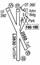
The 1983 Flight Guide (courtesy of Nelson Carpenter) depicted South Omaha Airport
as having 2 turf runways: 2,630' Runway 17/35 & 2,550' Runway 15/33.
A cluster of several buildings was depicted on the northeast corner of the field.
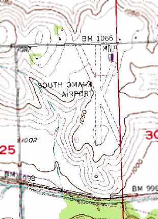
The 1984 USGS topo map depicted South Omaha Airport as having 2 turf runways, and several buildings on the northeast side.
Mike Zimmer recalled, “The Lt Col [who operated South Omaha Airport] retired from the Air Force in the summer of 1985
and they moved to MN where he flew for Northwest Airlines.
The FBO was shut down but the field remained operational for the people who hangared their planes there.”
Jim Brodigan recalled, “I flew gliders at the South Omaha Airport around 1985.
The Lt. Col. mentioned was a Major when I worked for them as a flight instructor.
His name was Bill Roester, his wife was Carol; they were a very friendly couple & I enjoyed my time working for them.
Major Roester was flying the E-4B when I worked there & his wife seemed to really run the airport business.
There was a glider club in the mid-1980s at the field & it had a Schweitzer 2-33 trainer as well as a single-seat fiberglass glider.”
According to Nelson Carpenter, “The airport closed in the mid-1980s following the early death of Harry McCandless.
The soon-to-be developer of Eagle Ridge had bought the airport leaving it open for a very short period until he finally closed it.
Apparently there was a better return on his investment with the construction and sale of new houses.”
The South Omaha Airport was closed by 1986, as it was no longer listed among active airfields in the 1986 Flight Guide (according to Chris Kennedy).
Mike Zimmer recalled, “By the time I left Offutt in 1987, the planes [at South Omaha Airport] were gone as well as the hangars & FBO building.”
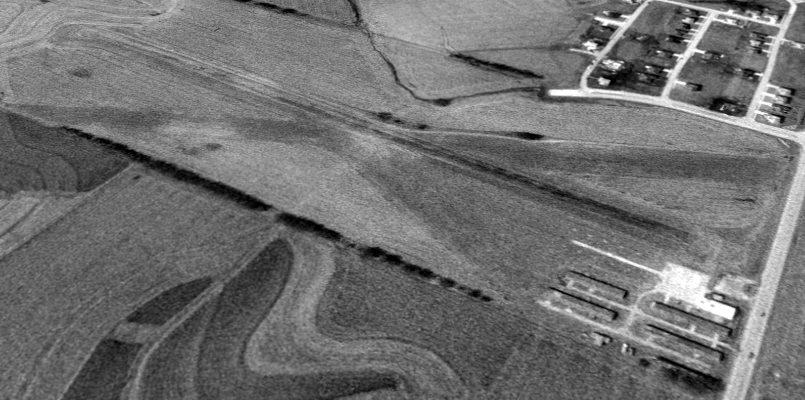
A 1993 USGS aerial view looking southwest showed South Omaha Airport remained intact, but there were no aircraft visible on the field.
However, Ray Anderson recalled South Omaha Airport still seeing some use at a later date:
“The airport was still used until the spring of 1995, when the developer asked all the planes to move off the field & they started building homes.
The hangars didn’t get torn down until after we left the airport in March of 1995.
From the stories I have heard, only one B-25 actually flew away from South Omaha.”
South Omaha Airport was no longer depicted on the July 1999 Omaha Sectional Chart.
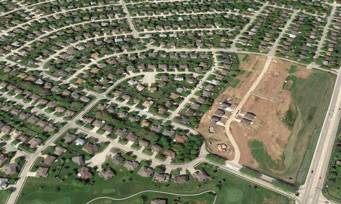
A 2017 aerial view looking southwest shows the site of South Omaha Airport bears no trace of having been an airport,
with the site covered by a sea of single-family houses.
Another small American grassroots airport replaced by our insatiable need for ever-more housing.
The site of South Omaha Airport is located southeast of the intersection of Cornhusker Road & Eagle Ridge Drive.
____________________________________________________
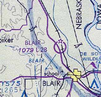
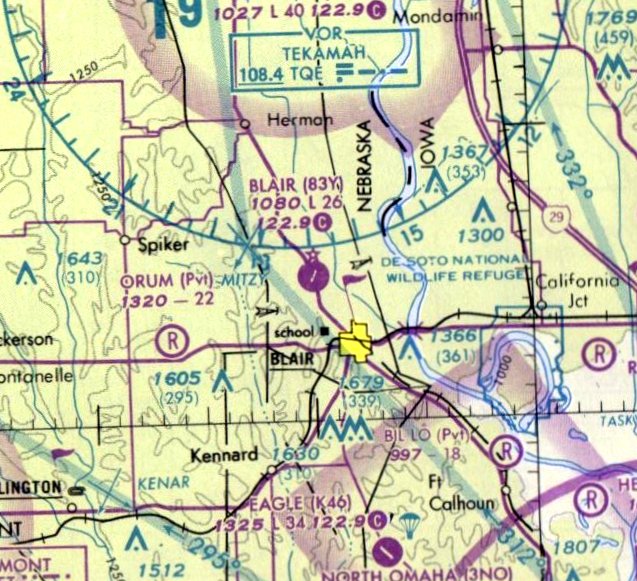
Blair Municipal Airport (83Y), Blair, NE
41.58, -96.16 (Northwest of Omaha, NE)
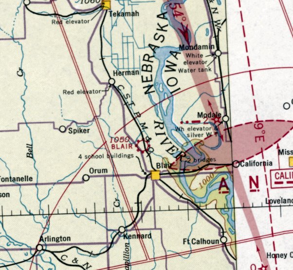
Blair Airport, as depicted on the June 1941 Lincoln Sectional Chart.
This small general aviation airport was evidently established at some point between 1938-41,
as it was not yet listed among active airfields in The Airport Directory Company's 1938 Airport Directory (according to Chris Kennedy).
The earliest depiction of Blair Airport which has been located was on the June 1941 Lincoln Sectional Chart.
It depicted Blair as a commercial/municipal airport.
The Airport Directory Company's 1941 Airport Directory (courtesy of Chris Kennedy)
described Blair Municipal Airport as consisting of a rectangular field, measuring 2,650' north/south by 1,400' east/west.
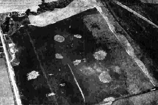
The earliest photo which has been located of Blair Municipal Airport
was a 9/26/43 aerial view from the 1945 AAF Airfield Directory (courtesy of Scott Murdock).
It depicted Blair as a sod field with some small buildings on the west side.
The 1945 AAF Airfield Directory (courtesy of Scott Murdock) described Blair Municipal Airport
as a 70 acre irregularly-shaped field with 4 sod runways, the longest being the 2,400' northeast/southwest strip.
The field was said to have 3 metal hangars, the largest measuring 60' x 50'.
Blair Municipal Airport was described as being owned by private interests but operated by the City of Blair.
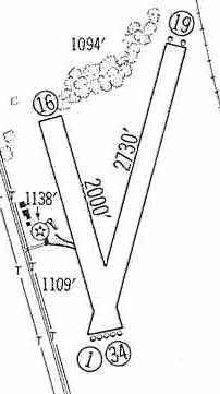
The 1959 Jeppesen Airway Manual (courtesy of Chris Kennedy)
depicted Blair Airport as having 2 unpaved runways (2,730' Runway 1/19 & 2,000' Runway 16/34),
with a ramp & several buildings on the west side of the field.
A 4/28/65 USGS aerial photo depicted Blair Airport as having 2 unpaved runways, with a ramp & a few small buildings on the west side.
No aircraft were visible parked outside.
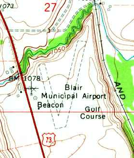
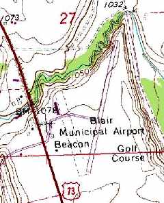
The 1970 USGS topo map depicted Blair Municipal Airport as having 2 unpaved runway, with a beacon on the west side.
Blair Airport was depicted on the March 1977 Omaha Sectional Chart (courtesy of Chris Kennedy)
as having a 2,800' unpaved runway.
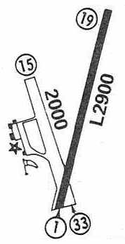
Blair Airport was evidently upgraded with a paved runway at some point between 1977-83,
as the 1983 Flight Guide (courtesy of Chris Kennedy)
depicted the field as having one 2,900' paved Runway 1/19 & a 2,000' unpaved Runway 15/33.
A ramp on the west side of the field was depicted as having several small buildings.
Blair Airport was still depicted on the 1983 USGS topo map.
Dan Hunt reported, “Everyone in the aviation (and economic development) community
knew that the then current airport (83Y) needed to be upgraded.
A longer, wider runway was necessary to attract the kind of aircraft owned by larger corporations.
New hangars & better fuel service was needed. We were interested in attracting an FBO.
But for several reasons, not the least of which was co-location with a golf course (which dates back to my grandfather's days),
it was decided that expansion at the then current location (83Y) was not our community's best option.”

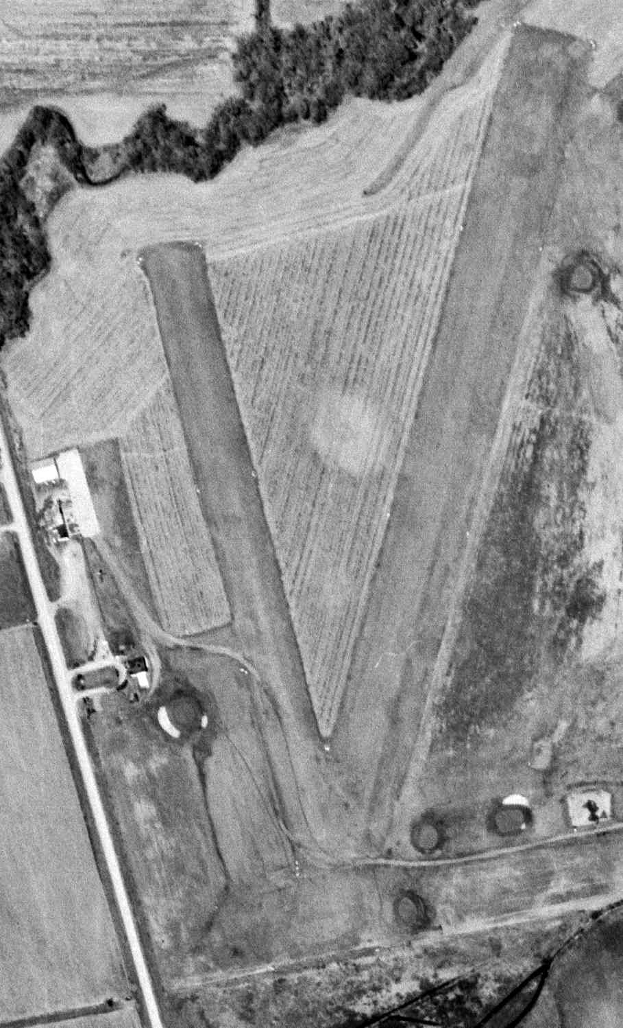
A 1988 USGS aerial view looking east depicted Blair Airport as remaining intact, bit was not evident if the airport was still open at that point.
The last aeronautical chart depiction which has been located of Blair Airport was on the 1994 Omaha Sectional Chart,
which depicted Blair as having a single 2,600' paved northeast/southwest runway.
Blair Airport was evidently closed at some point between 1994-99,
as it was no longer depicted on the July 1999 Omaha Sectional Chart.
A 1999 USGS aerial photo showed that Blair Airport had been swallowed up by the adjacent golf course,
but the southern portion of the former paved runway was still recognizable.
Dan Hunt reported in 2007, “The city purchased a private field south of town (K46)
and just last year completed a runway expansion that was voted
the best aviation construction project in the state for 2006 by our state Department of Aeronautics.”

A 2016 aerial view looking east showed the site of Blair Airport was unrecognizable as a former airport, with a golf course covering the property.
The only trace of the former airport was the concrete foundation for the former hangar, on the west side (bottom-left of photo).
The site of Blair Municipal Airport is located southeast of the intersection of Route 75 & North Creek Road.
____________________________________________________
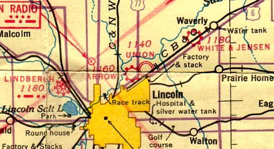
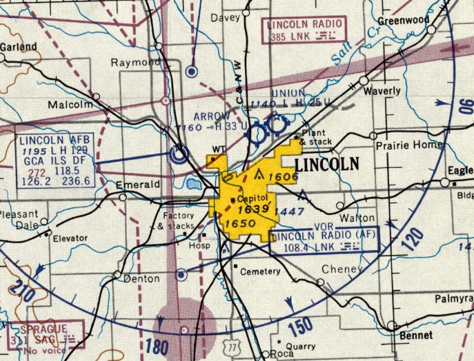
40.88, -96.64 (East of Lincoln Airport, NE)
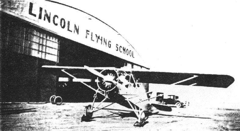
A circa 1927-28 photo (courtesy of Wayne Galvin) of the Skylark in front of the hangar of the Lincoln Flying School.
The Lincoln Airplane & Flying School operated a primary flying school at the Union Airport in the 1920s & 30s.
According to Wendell "Del" Harding Jr., "The airport was owned by my grandfather, E.J. Sias,
who also was president of the Lincoln Airplane & Flying School & Lincoln Aeronautical Institute.
He headed the flying school from 1920 until he retired about 1946."
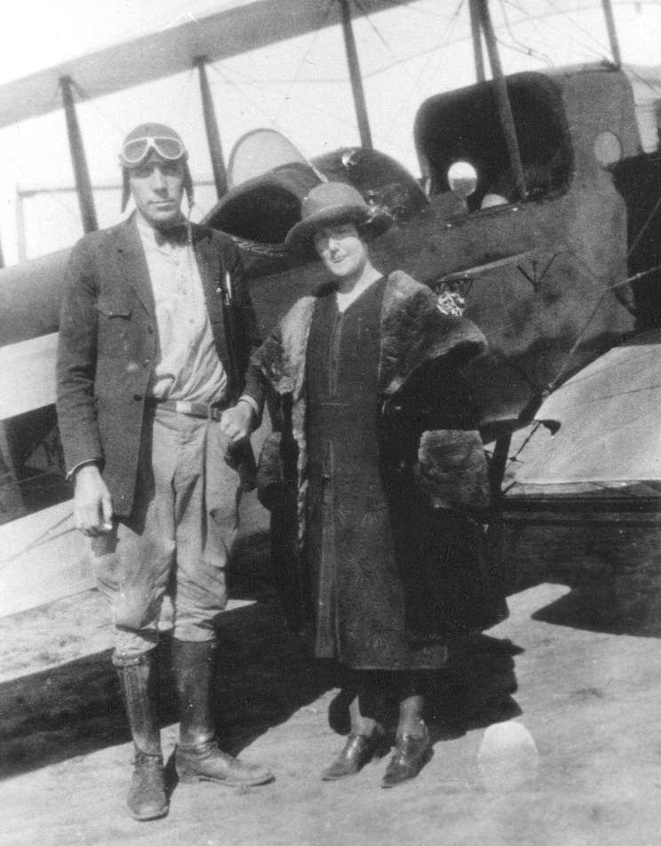
A 1926 photo (courtesy of Wayne Galvin) of Arnold & Dorothy Galvin in front of a Lincoln Page aircraft which he flew often.
According to Wayne Galvin, his father, Arnold Galvin, taught flying at the Lincoln Flying School.
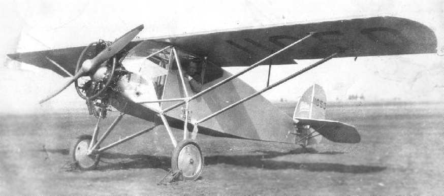
A circa 1927-28 photo (courtesy of Wayne Galvin) of a Skylark,
the sole example of which was built as a class project by the students of the Lincoln Flying School.
An aerial photo looking north at Union Airport,
from the Airport Directory Company's 1933 Airport Directory (courtesy of Chris Kennedy).
The Airport Directory Company's 1933 Airport Directory (courtesy of Chris Kennedy)
proclaimed Union to be "Nebraska's largest airport."
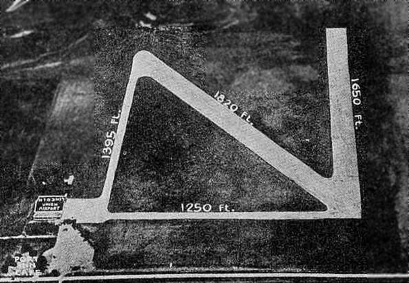
The field was described to have 2 asphalt runways: 1,820 northwest/southeast & 1,650' north/south.
A single hangar was depicted on the southwest corner of the field.
The manager was listed as Harry Sidles, and the operator was the Sidles Airways Corporation.
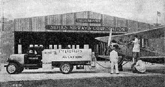
An unidentified biplane being refueled in front of the Sidles Airways Corporation hangar at Union Airport,
from the Airport Directory Company's 1933 Airport Directory (courtesy of Chris Kennedy).
The earliest aeronautical chart depiction which has been located of Union Airport was on the December 1935 Lincoln Sectional Chart.
It depicted Union as a commercial/municipal airport.
A 1939 aerial view looking northwest at the hangar & ramp at Union Airport (courtesy of Del Harding).
At this point, the airport had only one hangar.
A 1964 article in a Lincoln newspaper (courtesy of Del Harding) provided the following:
"In 1939, the Lincoln Airplane & Flying School, owned by the late E. J. Sias,
was chosen as one of 9 civilian schools in the US to give primary flight training to Army Air Corps cadets.
For 18 months Union Airport was literally buzzing with cadets flying the Stearman biplane trainers in a 2-way traffic pattern."
The article continued, "In 1940, Sias moved his cadet training school to Lakeland, FL,
and transferred his Civilian Pilot Training Program from the old Lincoln Municipal Airport to Union Airport.
At this time, Sias purchased Union Airport that he had been leasing from Harry Sidles.
The north (white) hangar at the airport was built in 1940
to serve as a field training base for Army Air Corps mechanics."
The January 1942 Lincoln Sectional Chart (courtesy of Jim Stanton) depicted Union as a military airfield.
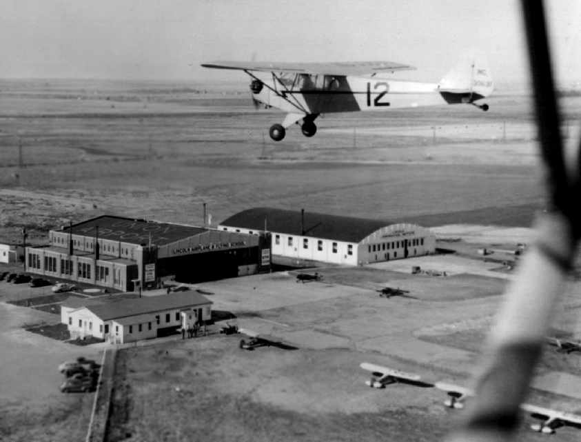
A circa 1942 aerial view looking northwest at the hangars & ramp at Union Airport (courtesy of Del Harding), with a Piper Cub flying overhead.
![]()
Union was depicted as a commercial/municipal airport on the August 1944 Lincoln Sectional Chart (courtesy of Chris Kennedy).
A 1964 article in a Lincoln newspaper (courtesy of Del Harding) provided the following:
""The Civilian Pilot Training Program... continued in operation at Union Airport until 1944.
Also, during the early part of this period,
hundreds of Army Air Corps mechanics received training in the north hangar,
which was built by Sias specifically for this mechanics training program."
This Inspection & Maintenance school was known as the Lincoln Aeronautical Institute.
Union Airport, as depicted on a 1945 street map (courtesy of Shawn McIlnay).
After the war, the airport was operated as a commercial field for the training of both civilian pilots & mechanics.
"Del" Harding recalled, "As a boy in 1946,
I worked at a miniature golf course adjacent to the rotating beacon [shown in a recent photo several paragraphs below].
I often climbed it at night for the view. The main Union Airport runway was directly east of the present buildings.
I learned to drive on it in 1948."
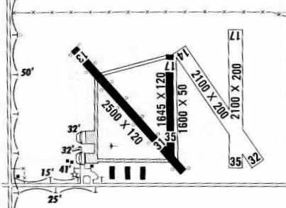
The 1950 NE Airport Directory (courtesy of Chris Kennedy)
depicted Union Airport as having as having 2 paved runways on the west side of the field (with the longest being the 1,800' Runway 13/31)
along with 4 unpaved runways on the east side of the field.
Taxiways led to the ramp at the southwest corner of the field with the 2 main hangars.
According to the 1964 Lincoln newspaper article (courtesy of Del Harding),
"In 1952, to assist in the re-activation of the Lincoln Air Force Base,
Sias leased Union Airport to the City of Lincoln for use as a municipal airport.”
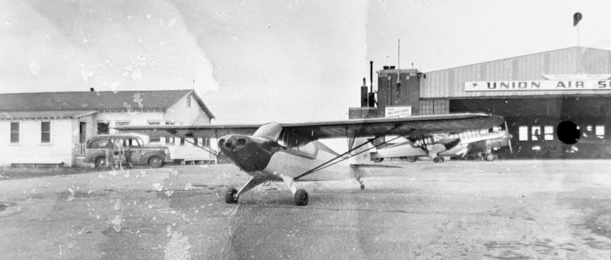
A circa 1950s photo (courtesy of Blaine Transue) of a Piper PA-12 in front of the Union Air Service hangar.
Blaine Transue reported, “My dad took lessons there, and I believe my uncle may have gotten his license there as well.”
A 9/12/53 USGS aerial view depicted Union Airport as having 2 paved runways on the west side, with 3 grass runways on the east side.
Note the grass Runway 8/26 depicted on the 1950 diagram was no longer evident.
Four rows of T-hangars had evidently been added just southeast of the 2 main hangars at some point between 1950-53.
A circa 1957 aerial view (courtesy of Steve Henrichsen of the Lincoln/ Lancaster County Planning Department)
depicted Union Airport as having 2 paved runways, 3 grass runways, and several hangars on the southwest side.
The 1959 NE Airport Directory (courtesy of Rob Branting)
depicted Union Airport as having 2 paved runways on the west side of the field (with the longest being the 2,500' Runway 13/31).
The number of unpaved runways on the east side of the field had decreased to 2.
Taxiways led to the ramp at the southwest corner of the field with the 2 main hangars.
In contrast to the 1957 photo, only 3 rows of T-hangars were depicted along the south side of the field.
The field was said to offer charter, flight training, ambulance and sales.
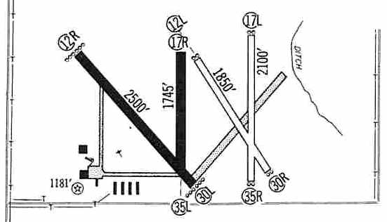
The 1960 Jeppesen Airway Manual (courtesy of Chris Kennedy)
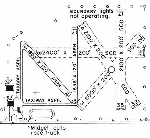
depicted Union Airport of having a somewhat unusual runway layout,
with 2 paved runways on the west side of the field (the longest being the 2,500' Runway 12R/30L)
and 2 unpaved runways on the east side of the field (the longest being the 2,100' Runway 17R/35R).
Taxiways led to the ramp at the southwest corner of the field
with the 2 main hangars & 4 rows of T-hangars.
The last aeronautical chart depiction which has been located of Union Airport was on the May 1960 Lincoln Sectional Chart.
It depicted Union as having a 2,500' paved runway.
Union Airport was listed among active airports in the 1962 AOPA Airport Directory,
with 2 paved runways (the largest was 2,500' long) & 2 grass runways,
and the operators listed as Lincoln Aviation Institute & Flight Line.
Bill McKee recalled, "As a Civil Air Patrol cadet I swept the (masonry) hangar.
The hangars were west of the flight line & runways. The empty field to the west of the hangars was empty then also.
I recall cattle in that area occasionally. I have many memories getting rides & training as a swap for sweeping."
An April 1964 aerial view of Union Airport (courtesy of Steve Henrichsen of the Lincoln/ Lancaster County Planning Department).
Although this was Union Airport's last year of operation, Steve noted that “Airplanes are still clearly visible in the photo.
It appears the 4 T-hangars were relocated to the northwest of the 2 main hangars at some point between 1960-64.
Planes are stacked wing to wing & back to back in the [previous] location of those 4 hangars.
I have the advantage of having the original photo & being able to examine it very close up.
You can see the footprint of each of the 4 buildings.
In the footprint to the left (western most) building, there are not any planes parked in the old footprint.
Moving to the right (east) the next footprint has 2 planes parked there, on the southern end of the footprint; both planes are facing east.
The 3rd footprint has 7 planes parked there, one facing east at the north end, then 3 facing west and 3 facing east on the southern end.
The eastern-most footprint has 8 planes parked there, 5 facing east & 3 facing east.
We can also see at least 22 other planes parked in front of the main hangars or out on the field.”
According to the 1964 Lincoln newspaper article (courtesy of Del Harding),
“Until 1964, the Lincoln Airport Authority operated Union Airport
for use by the flying public with fixed base operators in the 2 hangars.”
The article reported that Union Airport closed in 1964.
"When the airport authority completed its 4,000' civil runway at the (now deactivated) air base [Lincoln AFB],
all flying ceased at Union Airport.
Many private pilots were saddened to see the runways closed out
and the all-weather field plowed up preparatory to industrial development.
The last take-off & landing had been made at Union Airport."
The article also stated, "The 55' high beacon tower whose green & white flashing light for almost 4 decades
beckoned many grateful pilots to a safe night landing… still rotates a welcoming light.
Only now the light is purple & its purpose is to bring new industry to Lincoln… (to) the new Sias Industrial Center."
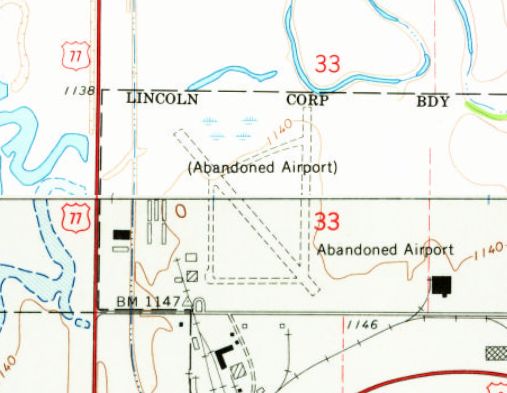
The 1964 USGS topo map still depicted the 2 unpaved runways & taxiways of Union Airport,
along with the airport buildings, but the site was labeled “Abandoned Airport”.
"Del" Harding recalled, "When the airport was closed, my father, Wendell W. Harding,
was the real estate broker who on behalf of my grandmother, Mrs. E.J. Sias,
developed the plans for & sold lots on what became an industrial park."
He added that "Union Airport's size was 320 acres."
The Union Airport was not depicted at all on the October 1965 Lincoln Sectional Chart (courtesy of Ron Kunse),
nor on USGS topo maps of the area from 1980, 1981, or 1986.
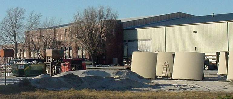
A 2001 photo by Scott Murdock of one distinctive masonry hangar which remains standing.
![]()
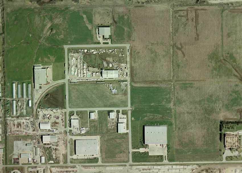
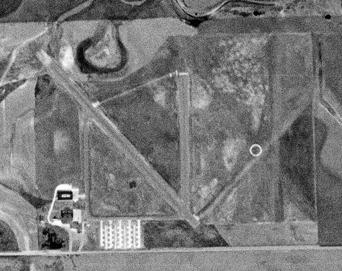
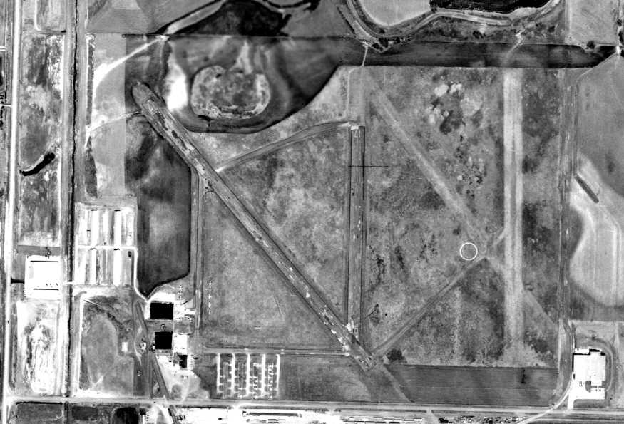
As seen in the 2002 USGS aerial photo, the site is not necessarily recognizable from the air as a former airfield,
as the surrounding area has been redeveloped as an industrial park.
However, several traces of the former Union Airport are still visible, including the 2 hangars which remain standing (at the southeast corner of the site),
3 of the 4 original T-hangars (moved to a site northwest of the main hangars),
and remarkably the outline of the former paved Runway 12R/30L is still plainly recognizable in the grass, just to the left of the center of the photo.
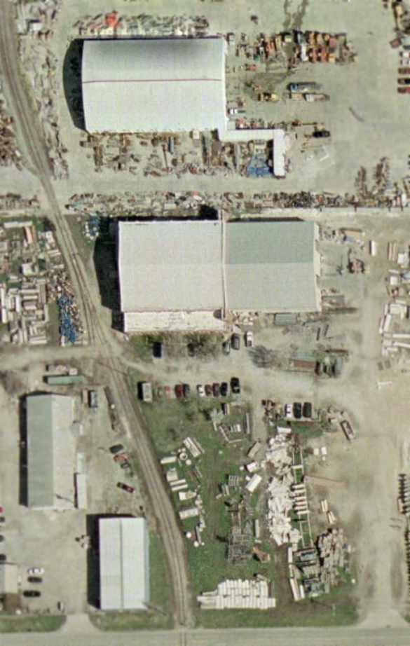
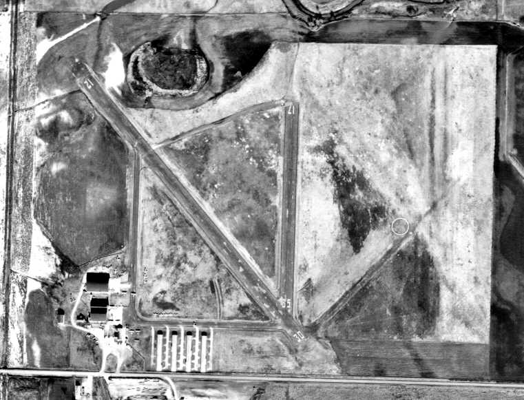
A close-up from the 2002 USGS aerial photo, showing the 2 hangars which remain standing,
as well as the former airport light beacon tower (bottom of photo, orange in color, and note its shadow extending to the northwest).
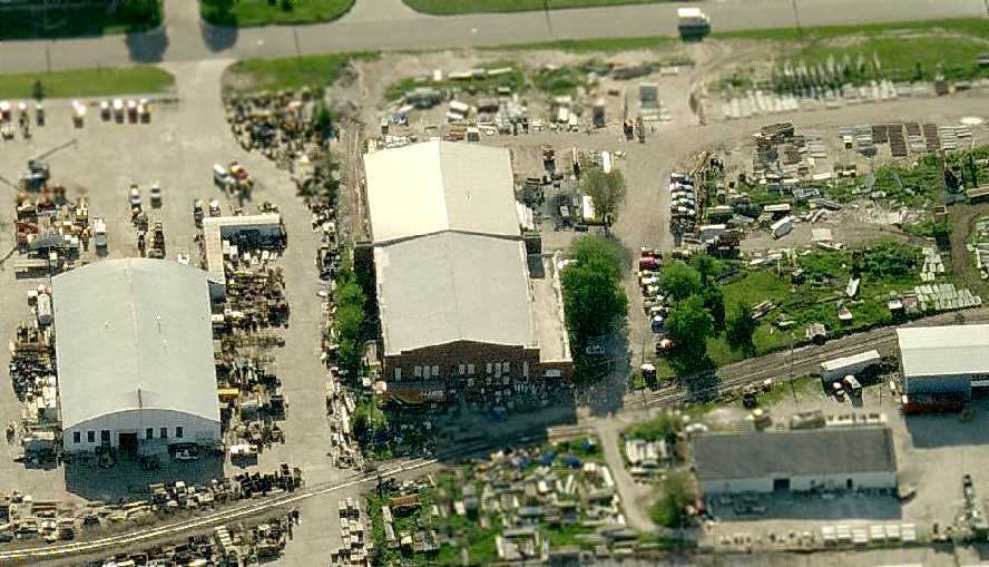
A circa 2006 aerial view looking east at the 2 remaining hangars from Union Airport,
as well as the former airport light beacon tower (right side of photo, barely discernible amongst all of the stored equipment on the property).
A 2006 photo of the 3 remaining Union Airport T-hangars (courtesy of Steve Henrichsen of the Lincoln/ Lancaster County Planning Department).
Three of the original 4 T-hangars are intermixed with 5 newer buildings.
A 2007 photo of one of the remaining Union Airport T-hangars (courtesy of Steve Henrichsen of the Lincoln/ Lancaster County Planning Department).
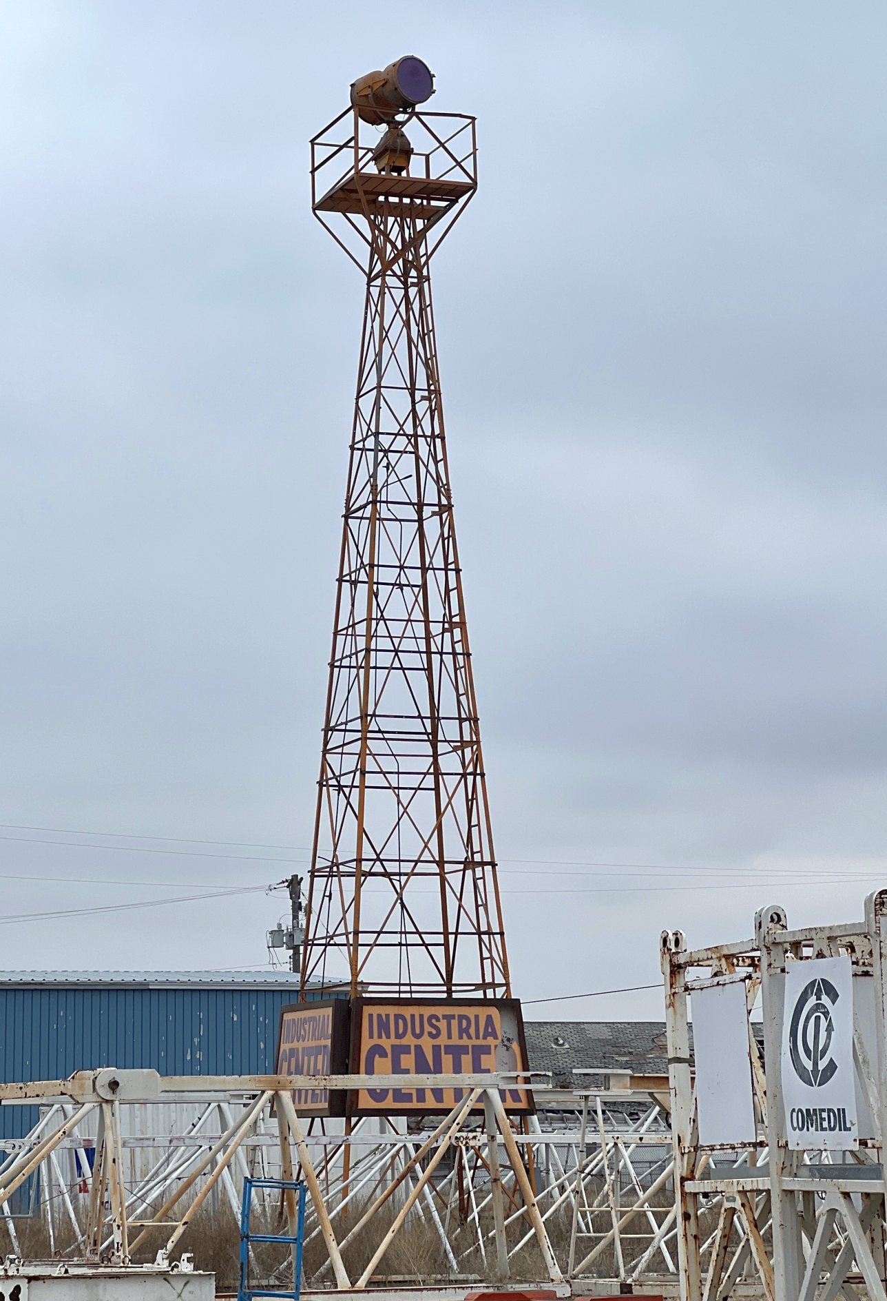
A 3/10/23 photo by Shawn McIlnay of the rotating beacon which remains standing south of the masonry hangar at the site of Union Airport.
Shawn reported, “It looks much the same as the 2001 photo.”
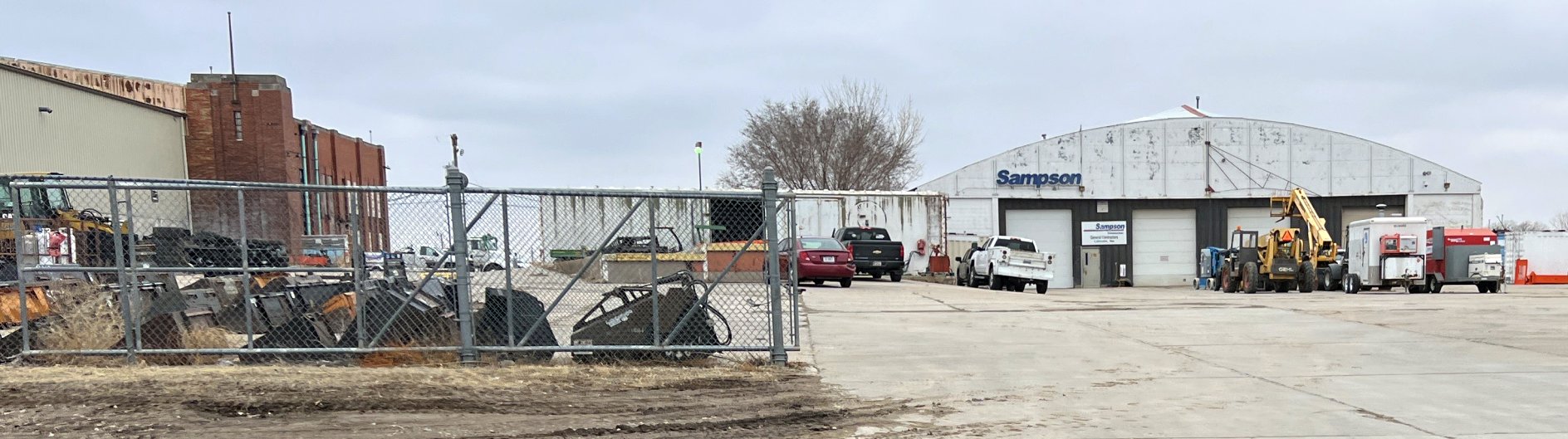
A 3/10/23 photo by Shawn McIlnay of former Union Airport hangars.
The site of Union Airport is located north of the intersection of Fletcher Avenue & North 70th Street.
According to Del Harding, the original boundaries of the airport were:
"U.S. Highway 77 on the west, Fletcher Avenue on the south, and North 70th Street on the east.
The hangars & other buildings all were located in the western portion of the airport. The northern boundary was a large gully."
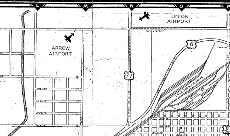
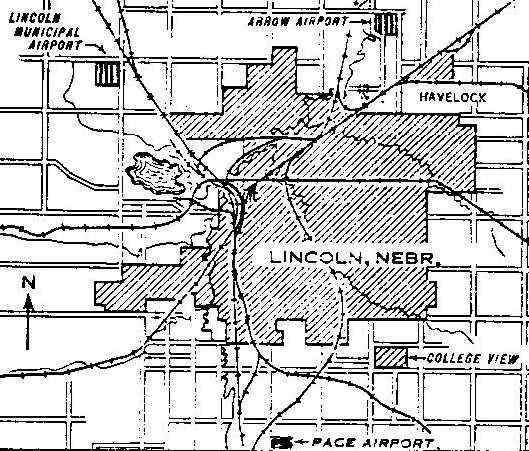
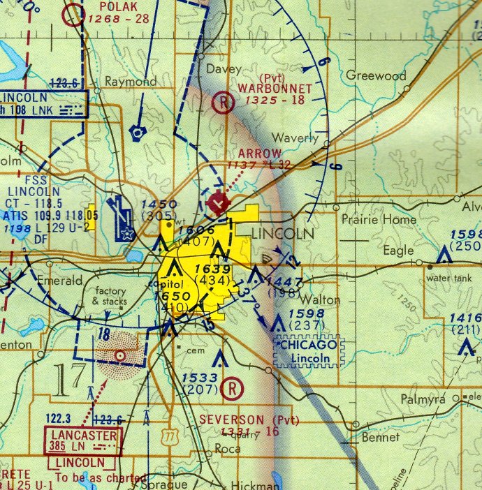
The former Arrow Airport was located only 1 mile west of the site of Union Airport.
See also: http://www.airforcebase.net/trips/solo/solo.html
____________________________________________________
40.867, -96.655 (East of Lincoln Airport, NE)
Arrow Airport shown on the northeast corner of a map of airports in the Lincoln area, from a 1929 Department of Commerce Airway Bulletin (courtesy of Steve Green, via Jeff King).
According to Wikipedia, “Arrow Airport was established around 1925 as a manufacturing & test facility for Arrow Aircraft & Motors Corporation, primarily the Arrow Sport.
The airfield was near Havelock.”
The earliest depiction which has been located of Arrow Airport
was on the 1929 Department of Commerce Airway Bulletin (courtesy of Steve Green, via Jeff King).
An article entitled “$15,000 Arrow Aircraft Hangar Nearing Completion” appeared in the 7/6/29 issue of Air Transportation (courtesy of Noah Rechtin).
It said “80' x 100' hangar will house 15 Arrow sport planes.”
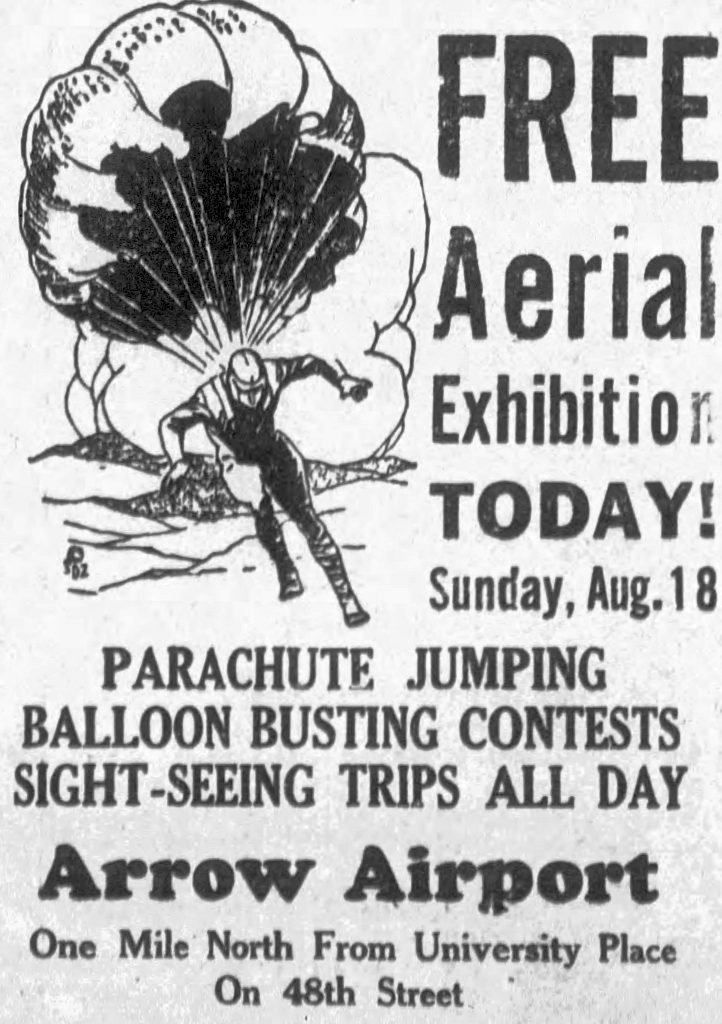
An advertisement for an Aerial Exhibition at Arrow Airport from the 8/18/29 NE State Journal.
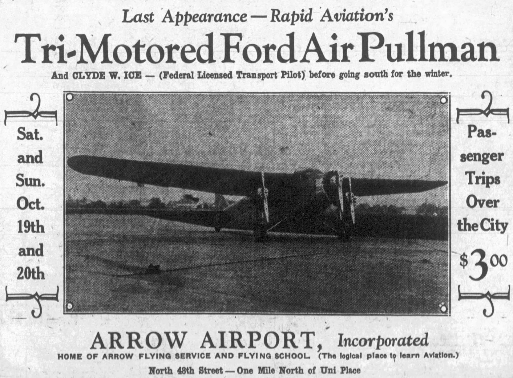
An advertisement for an appearance by a “Tri-Motored Ford Air Pullman” at Arrow Airport from the 10/19/29 NE State Journal.
The earliest aeronautical chart depiction which has been located of Arrow Airport was on the December 1935 Lincoln Sectional Chart.
It depicted Arrow as a commercial/municipal airport.
According to Wikipedia, “Arrow Aircraft & Motors declared bankruptcy in 1939.”
The earliest photo which has been located of Arrow Airport
was a 9/26/43 aerial view looking east from the 1945 AAF Airfield Directory (courtesy of Scott Murdock).
It depicted Arrow as a sod field with a single hangar on the east side.
The 1945 AAF Airfield Directory (courtesy of Scott Murdock) described Arrow Airport
as a 160 acre irregularly-shaped field with 2 sand & sod runways, measuring 2,500' north/south & 2,000' east/west.
The field was said to have a single 100' x 80' concrete block hangar.
Arrow Airport was described as being owned & operated by private interests.
![]()
Arrow was depicted as an auxiliary airfield on the August 1944 Lincoln Sectional Chart (courtesy of Chris Kennedy).
Arrow Airport, as depicted on a 1945 street map (courtesy of Shawn McIlnay).
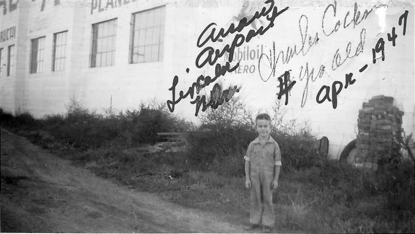
The only ground-level photo which has been located of Arrow Airport was an April 1947 photo of a 4 year old Charles Cocks behind a hangar.
Charles Cocks recalled, “My Father Winston (Bud) Cocks was the mechanic at Arrow in 1947, and we lived on-site.”
![]()
The 1950 NE Airport Directory (courtesy of Chris Kennedy)
depicted Arrow Airport as having as having a total of 5 unpaved runways, with the longest being the 2,500' Runways 8/26 & 17/35.
A cluster of buildings were located along the east side of the field.
A 9/12/53 USGS aerial view depicted Arrow Airport as having as having 5 unpaved runways & several buildings on the east side.
![]()
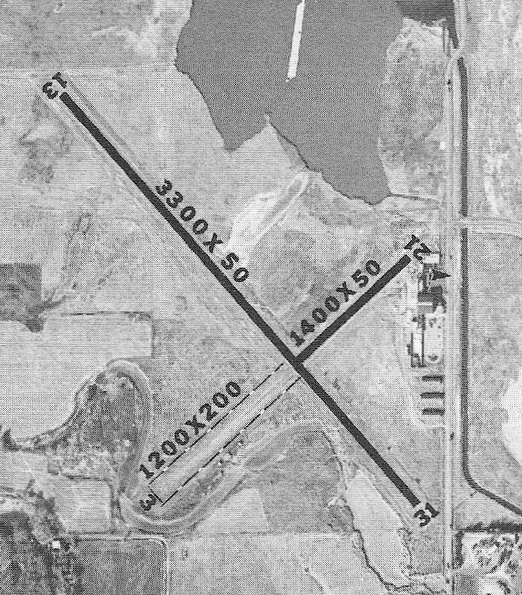
Arrow Airport has gained paved runways at some point between 1953-59, as the 1959 NE Airport Directory (courtesy of Rob Branting)
depicted the field as having a 3,300' paved Runway 13/31, along with a 2,400' crosswind runway of which 1,200' was paved.
Several hangars were depicted along the east side of the field. The operator was listed as Arrow Aviation.
Storage included hangars & tie-downs, and a restaurant was located on the field.
According to Rob Branting (Lincoln AFB Historian), "I believe this field was considered by the city of Lincoln as a new airport location
once SAC virtually took over the current Lincoln airport.
Plans never progressed, however Lincoln newspaper articles during the 1959 period
noted plans to build a new municipal airport east of the city; this was never built."
Arrow Airport was described in the 1962 AOPA Airport Directory as having with 2 bituminous runways (the largest was 3,300' long),
and the operator listed as Arrow Aviation.
The 1964 USGS topo map depicted Arrow Airport as having 2 paved runways, and 6 buildings along the east side.
The last aeronautical chart depiction which has been located of Arrow Airport was on the September 1971 Omaha Sectional Chart,
which depicted Arrow as having 2 paved runways, with the longest being 3,200'.
![]()
The 1972 Flight Guide (courtesy of Chris Kennedy) depicted Arrow Airport
as having a small ramp on the east side of the field, with a total of 4 buildings (hangars?).
![]()
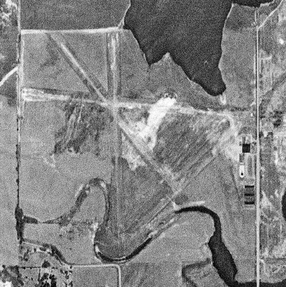
The last photo which has been located of Arrow Airport was a 5/18/72 USGS aerial view.
It depicted Arrow as having 2 paved runways, with several hangars & 3 single-engine aircraft on the east side.
Am undated aerial view of Arrow Airport from the 1976 NE Airport Directory (courtesy of Dave Krenk).
It depicted Arrow as having 2 paved runways, with several hangars on the east side.
Dave Krenk recalled, “I flew in & out of Arrow Airport a few times in the late 1970s as I was finishing up flight training.
The airport was in rough shape & showing signs of disrepair: rough runway surface, some runway lights not working.
In 1976 the airport manager was Geoff Gallup. At that time Geoff & probably James Armstrong were just starting their Air Freight operation.
In 1980 they moved 'Suburban Air Freight' to the Crete Airport.”
![]()
Arrow Airport was still depicted on the 1980 USGS topo map.
Rob Branting reported of Arrow Airport, "I've heard stories of parachuters using the field up until at least the 1980s."
Arrow Airport was depicted as “Closed” on the 1985 NE Aeronautical Chart (courtesy of Dave Krenk).
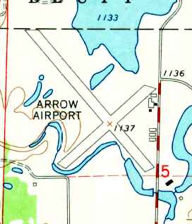
Arrow Airport field was still depicted on the 1986 USGS topo map, but was simply labeled "Landing Strip".
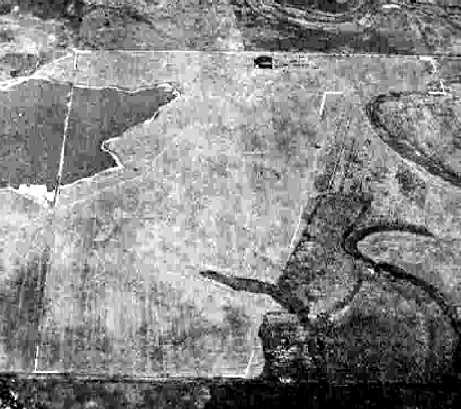
The 1993 USGS aerial photo depicted that the Arrow Airport site had become an empty field.
Rob Branting (Lincoln AFB Historian) reported in 2004 that "Arrow sits near an old city landfill the way it looks,
I believe it is known as Boosalis Park today."
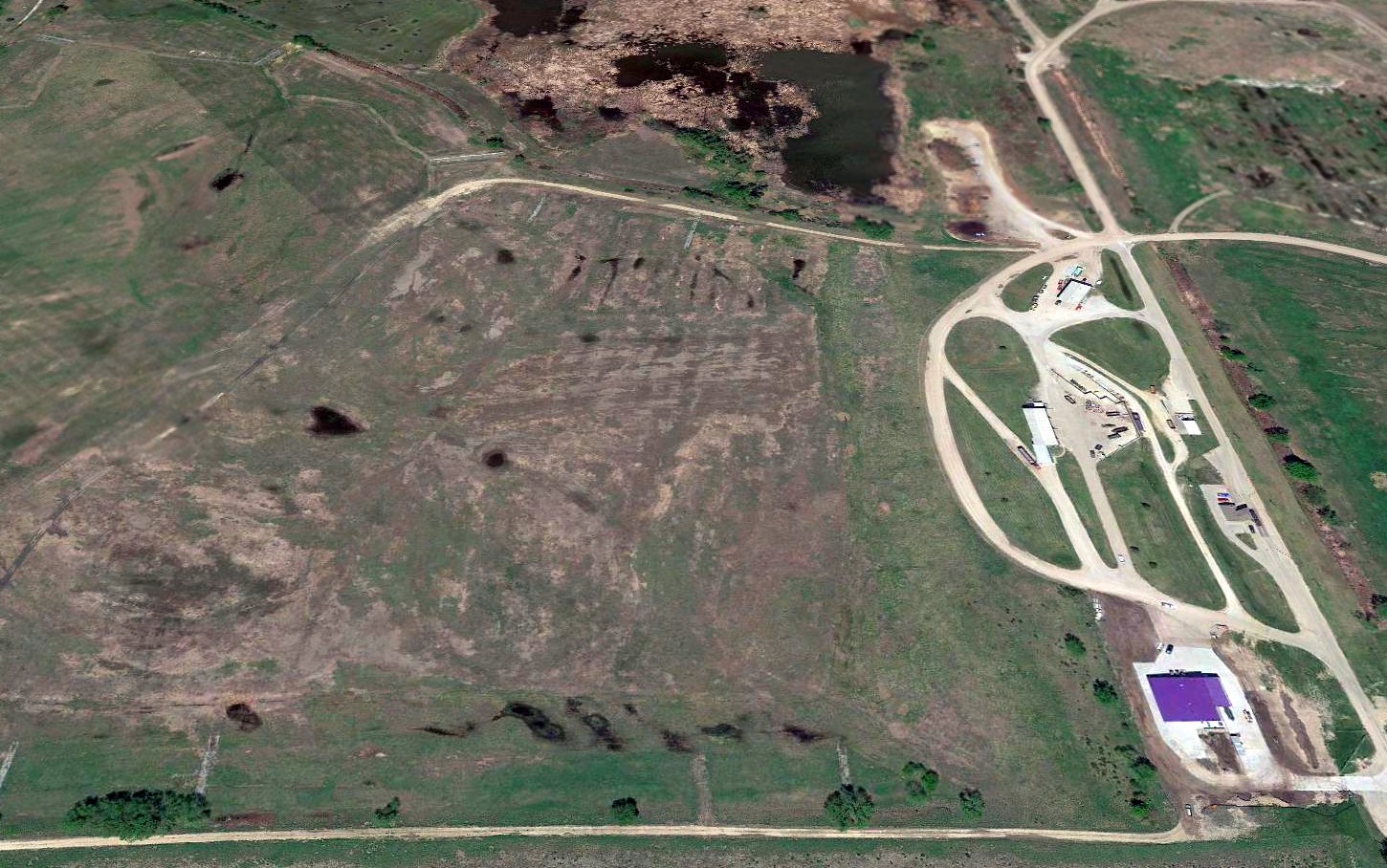
A 2017 aerial view looking north shows the site of Arrow Airport is no longer recognizable as a former airfield.
The only remaining trace of the airport is the set of roads on the east side which used to lead to the hangars.
The former Union Airport was located only 1 mile east of Arrow Airport.
____________________________________________________
Since this site was first put on the web in 1999, its popularity has grown tremendously.
If the total quantity of material on this site is to continue to grow,
it will require ever-increasing funding to pay its expenses.
Therefore, I request financial contributions from site visitors,
to help defray the increasing costs of the site
and ensure that it continues to be available & to grow.
What would you pay for a good aviation magazine, or a good aviation book?
Please consider a donation of an equivalent amount, at the least.
This site is not supported by commercial advertising –
it is purely supported by donations.
If you enjoy the site, and would like to make a financial contribution,
you
may use a credit card via
![]() :
:
Please consider checking the box to make a monthly donatation.
For a mailing address to send a check, please contact me at: paulandterryfreeman@gmail.com
If you enjoy this web site, please support it with a financial contribution.
please contact me at: paulandterryfreeman@gmail.com
If you enjoy this web site, please support it with a financial contribution.
____________________________________________________
This site covers airfields in all 50 states.