Abandoned & Little-Known Airfields:
Northwestern Mississippi
© 2002, © 2023 by Paul Freeman. Revised 11/12/23.
____________________________________________________
Please consider a financial contribution to support the continued growth & operation of this site.
De Soto Airpark (revised 11/19/21) - Greenville Municipal (revised 10/18/20) - Greenwood Municipal Airport (revised 11/19/21)
Oxford Municipal Airport (revised 2/23/20) – Sanders Field / Twinkle Town Airport (revised 11/12/23) - Yazoo City Airport / Barrier Airport (revised 2/23/20)
____________________________________________________
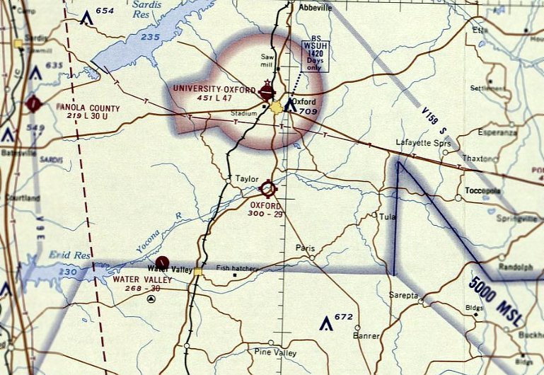
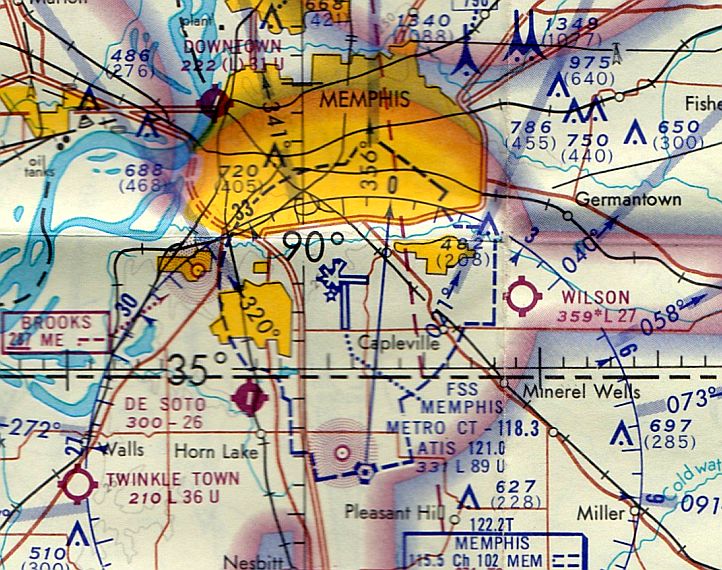
Oxford Municipal Airport, Oxford, MS
34.262, -89.528 (Southeast of Memphis, TN)
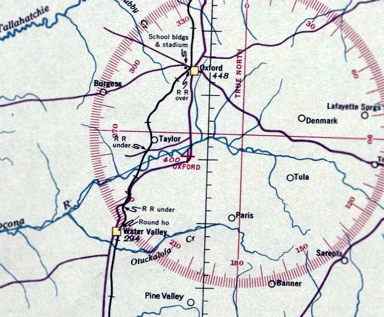
Oxford Airport, as depicted on the February 1937 Chattanooga Sectional Chart.
Oxford Municipal Airport was evidently established at some point between 1936-37,
as it was not yet depicted on the September 1936 Chattanooga Sectional Chart.
The earliest depiction which has been located of Oxford Municipal Airport was on the February 1937 Chattanooga Sectional Chart.
It depicted Oxford Airport as an auxiliary airfield.
The Airport Directory Company's 1937 Airport Directory (courtesy of Bob Rambo)
described Oxford Airport as an auxiliary airfield having two 2,000' runways, oriented north/south & east/west.
It also indicated “West portion of field under construction.”
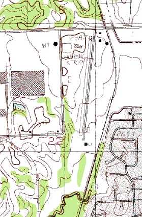
The 1940 USGS topo map depicted Oxford Airport as an irregularly-shaped property outline.
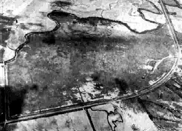
The earliest photo which has been located of Oxford Municipal Airport
was a 6/3/43 aerial view looking north from the 1945 AAF Airfield Directory (courtesy of Scott Murdock).
The 1945 AAF Airfield Directory (courtesy of Scott Murdock) described Oxford Municipal Airport
as a 193 acre irregularly-shaped shaped field having 2 sod runways, measuring 3,000' northeast/southwest & 2,007' northwest/southeast.
The field was said to have 3 hangars, the largest being an 80' square metal structure.
The airport was described as being owned & operated by the City of Oxford.
According to Matthew Clapp, “A customer told me that it used to be a bomber training field.”
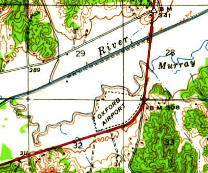
Oxford Airport, as depicted on the 1956 USGS topo map.
The 1965 USGS topo map continued to depict Oxford Airport as an irregularly-shaped property outline.
The last aeronautical chart depiction which has been located of Oxford Municipal Airport was on the August 1968 Chattanooga Sectional Chart.
It depicted Oxford Airport as having a 2,900' unpaved runway.
Oxford Airport was evidently closed (for reasons unknown) at some point between 1968-81,
as it was no longer depicted on the 1981 USGS topo map (although 2 buildings were depicted on the southeast portion of the site).
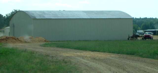
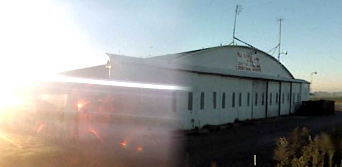
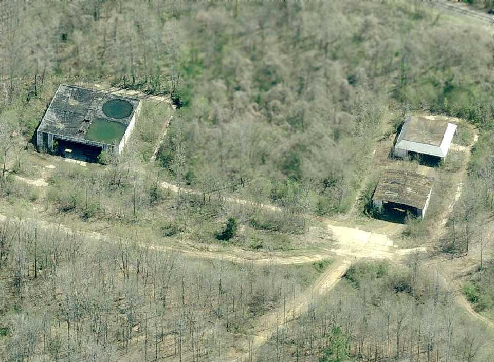
A 2005 photo by Matthew Clapp of the 1940s-era hangar which remains standing at the site of Oxford Municipal Airport.
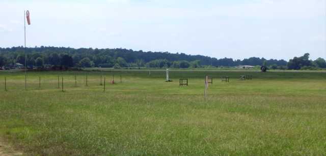
A 2005 photo by Matthew Clapp of a windsock at the site of Oxford Municipal Airport.
Matthew reported in 2005, “Oddly enough a portion of the north part of the old field is used for a radio-controlled [model] airplane club.”
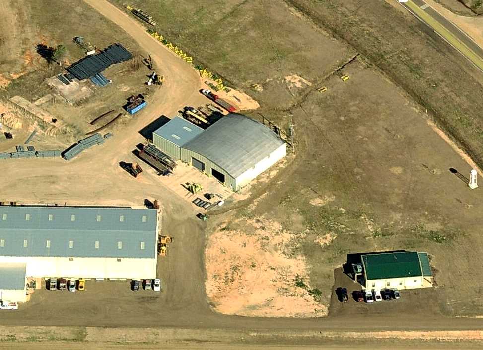
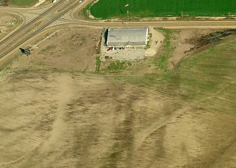
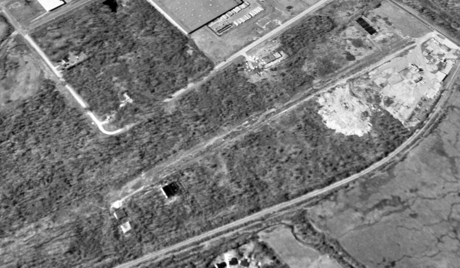
A circa 2004-2009 aerial view looking north at the former Oxford hangar.
Matthew Nichols reported in 2011, “The site has been taken over by McGregor Steel Corporation
and they have completely remodeled the hangar, including raising the roof on it & putting new metal siding on it.
There was also a small store directly across the highway called 'Airport Grocery' but it has closed down recently & the sign removed.”
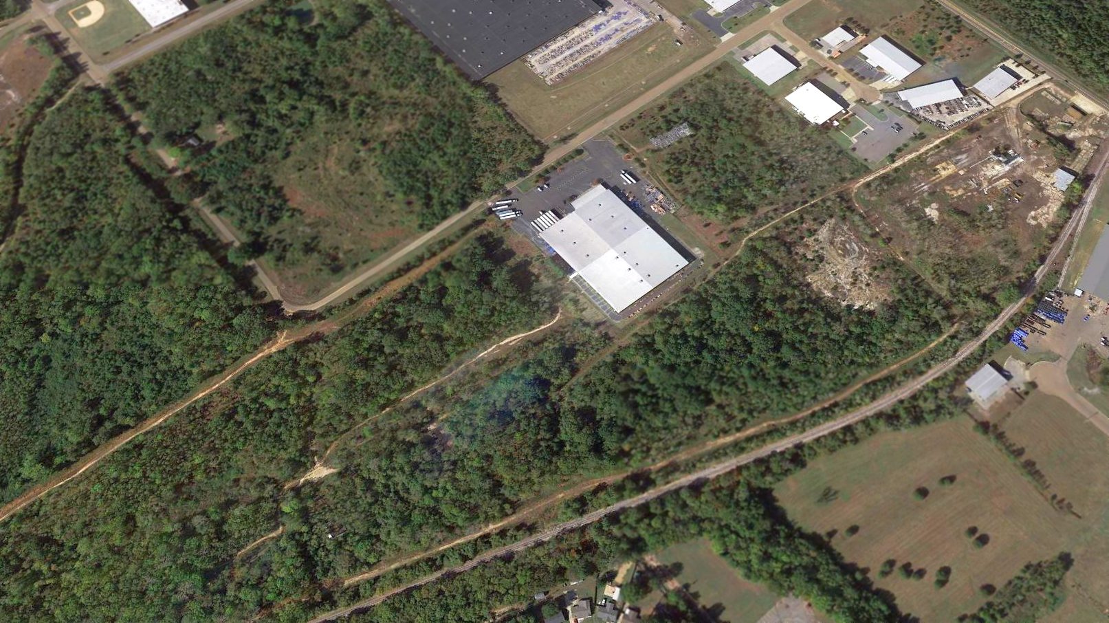
The site of Oxford Municipal Airport is located southwest of the intersection of Route 7 & Route 9W.
____________________________________________________
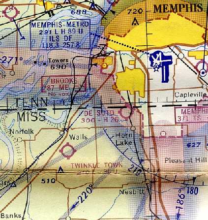
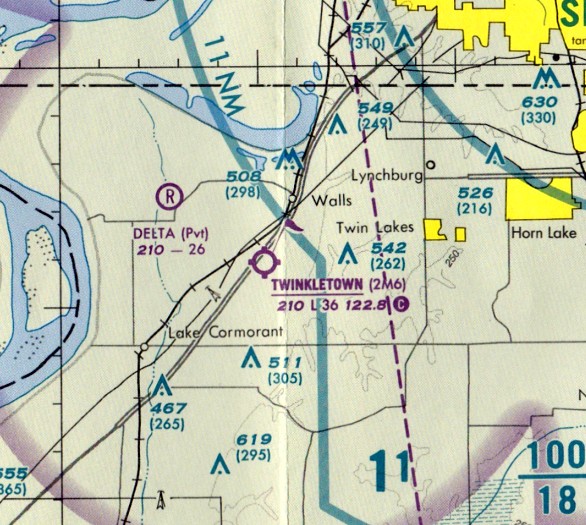
Sanders Field / Twinkle Town Airport, Walls, MS
34.93, -90.17 (Southwest of Memphis, TN)
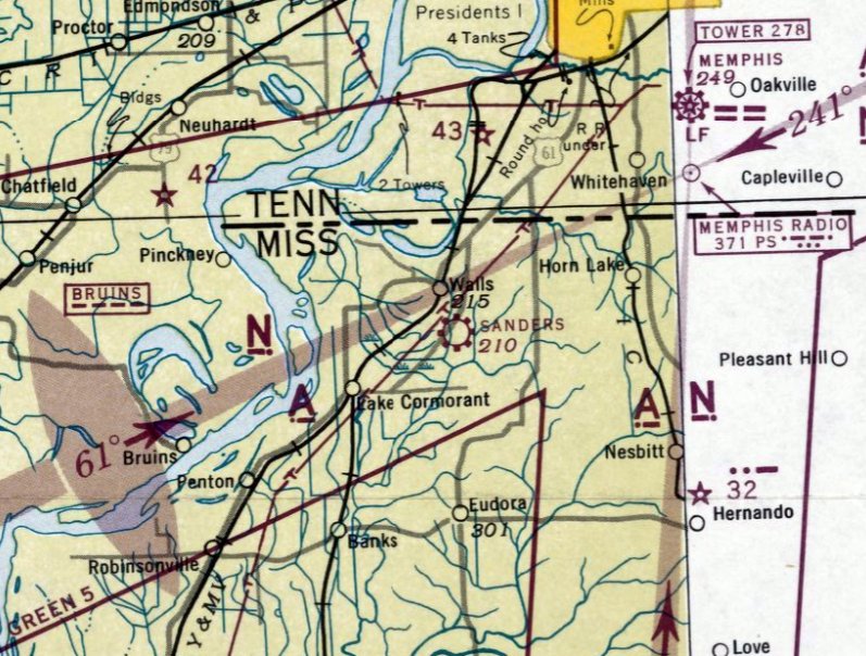
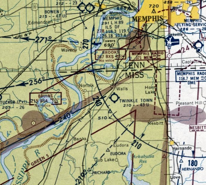
Sanders Field, as depicted on the March 1944 Little Rock Sectional Chart.
Sanders Field was evidently established at some point between 1942-43,
as it was not yet depicted on the July 1942 Little Rock Sectional Chart.
The earliest reference which has been located of Sanders Field was in the 1943 Directory of Airfields (courtesy of Scott Murdoch).
However it only contained the note "No data available", and listed the airport in Glover (a part of Walls, MS).
The earliest depiction which has been located of Sanders Field was on the March 1944 Little Rock Sectional Chart,
which depicted Sanders as a commercial/municipal airport.
Sanders Field gained a full listing in the December 1944 Directory of Airfields (courtesy of Scott Murdoch), and was properly listed in the town of Walls.
It described the longest runway as 5,400', much longer than subsequent listings.
The earliest photo which has been located of Sanders Field was an undated aerial view from the 1945 Army Air Field Directory (courtesy of Scott Murdoch).
It described Sanders Field as a 167 acre irregularly-shaped property having 4 sod runways, the longest meas uring 5,400' northeast/southwest.
It was said to have a single 200' x 100' metal hangar, and to be owned & operated by private interests.
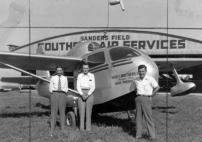
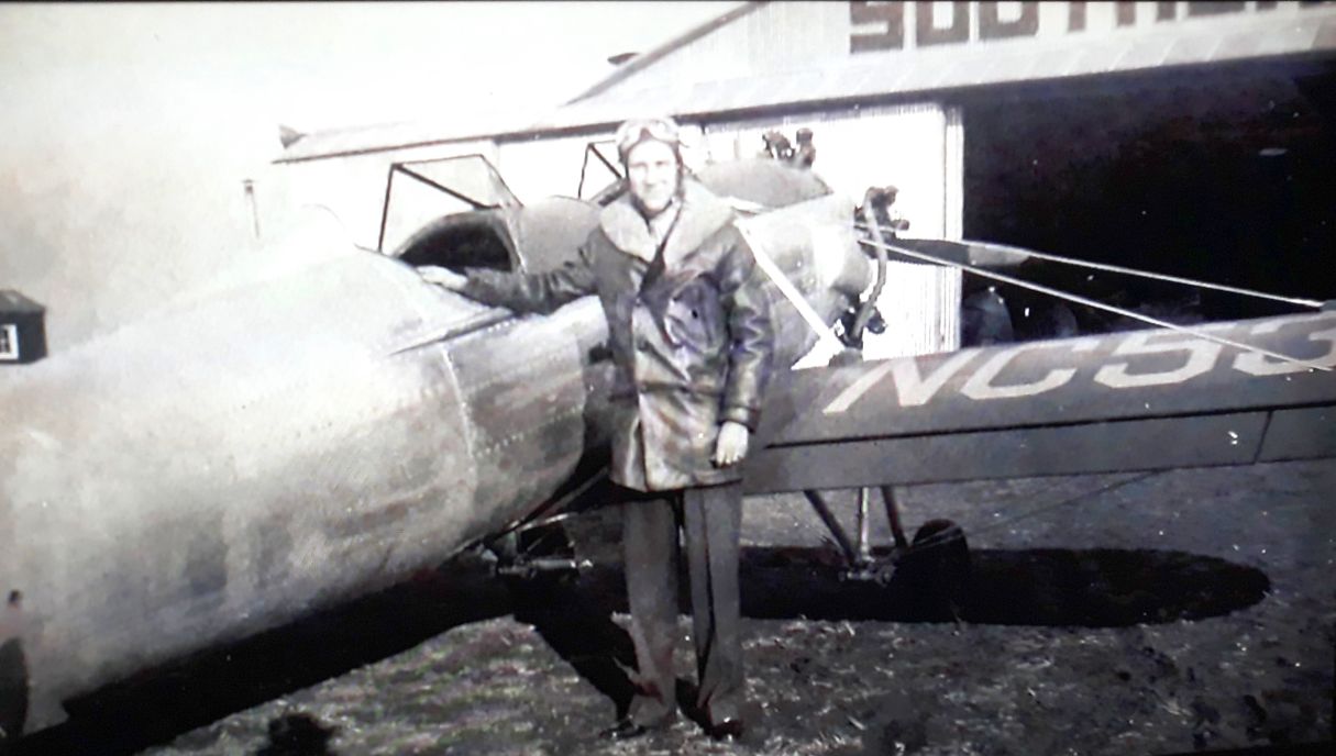
The earliest ground-level photo which has been located of Sanders Field was a circa 1940s photo (courtesy of Lee Corbin)
of 3 men in front of a Republic SeaBee amphibian owned by Nickeys Brothers Wood Products of Memphis in front of the Sanders Field Southern Air Services hangar.
Why would a company from Memphis want a seaplane?
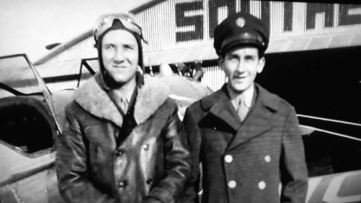
A circa 1950 photo of Creighton Evans & another flight student in front of the Sanders Field Southern Air Services hangar (courtesy of Charlie Evans).
A circa 1950 photo of Creighton Evans & a Ryan PT-19 in front of the Sanders Field Southern Air Services hangar (courtesy of Charlie Evans).
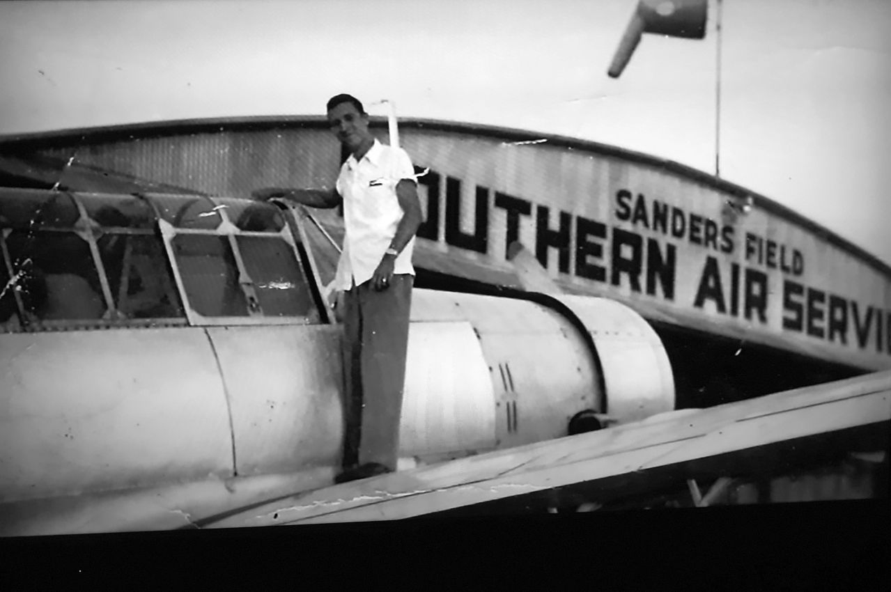
A circa 1950 photo of Creighton Evans & a Vultee BT-13 in front of the Sanders Field Southern Air Services hangar (courtesy of Charlie Evans).
The last depiction which has been located of Sanders Field was on the August 1954 Little Rock Sectional Chart,
which depicted Sanders as having a 4,600' unpaved runway.
Sanders Field was evidently closed (for reasons unknown) at some point between 1954-55,
as it was no longer depicted on the February 1955 thru February 1957 Little Rock Sectional Charts.
At some point between 1957-58, Twinkle Town Airport reopened on the site of Sanders Field.
The 1957 Airman's Guide (courtesy of Jonathan Westerling) noted,
"WALLS-TWINKLE TOWN ARPT: Reactivated. Formerly carried as Sanders Field."
Jonathan Westerling reported, “The field was named Twinkle Town by its founder Jack Adams.”
The earliest depiction which has been located of Twinkle Town Airport was on the February 1958 Little Rock Sectional Chart.
It depicted Twinkle Town Airport as having a 4,300' unpaved runway.
David Jones recalled, “Twinkletown Airport... was the home of Jack Adams Sr. Aircraft Sales during the 1950s thru the 1970s.”
The 1961 USGS topo map depicted Twinkle Town Airport as having 3 runways & a building on the north side.
The July 1964 Little Rock Sectional Chart (courtesy of Chris Kennedy) depicted Twinkle Town Airport as having a 3,600' unpaved runway.
Chalres Brawner recalled, “Twinkle Town... My grandpa was Joe Hopkins.
I remember that place he owned it at one time. I had a lot of fun there & have a lot of good memories.”

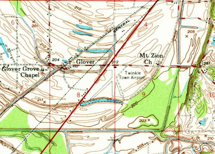
Twinkle Town Airport, as depicted on the 1965 USGS topo map.
Jonathan Westerling reported, “According to 'My First Tractor: Stories of Farmers & Their First Love',
an interesting footnote to the airfield is that Adams also owned a farm & named it Twinkle Town after the airfield.
Elvis Presley fell in love with Twinkle Town Farm & purchased it from Adams in 1967 renaming it the 'Circle G' & using it for his honeymoon with Priscilla.”
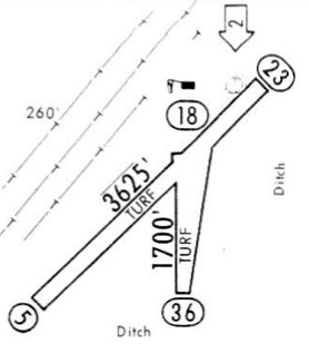
A 1968 airport directory (courtesy of Jonathan Westerling) depicted Twinkle Town Airport as having 2 turf runways (3,625' Runway 5/23 & 1,700' Runway 18/36),
and a single building north of the runway intersection.
The December 1968 Memphis Sectional Chart (courtesy of Ron Plante) depicted Twinkle Town as having a 3,600' unpaved runway.
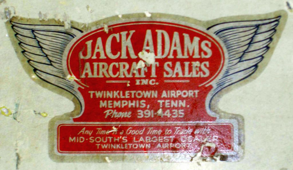
A 2014 photo by Robert Brown of a circa 1950s-70s decal for Jack Adams Aircraft Sales; Twinkletown Airport.
Robert reported, “This is on a Cessna 170 fin in my hangar.
When a retired airline pilot who started his flying career in Kentucky in the 1950s & 1960s saw it, he had to take a photo; there used to be a lot of airplanes sold by Jack Adams.”
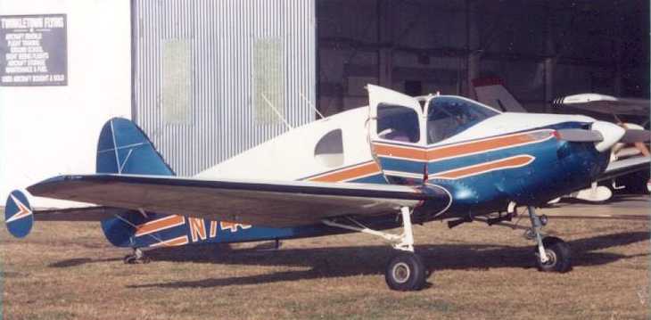
The earliest photo which has been located of Twinkle Town Airport was a 1971 photo of a Bellanca outside a hangar marked Twinkletown Flying.
The November 1974 Memphis Sectional Chart (courtesy of Ron Plante) depicted Twinkle Town as having a 3,600' unpaved runway.
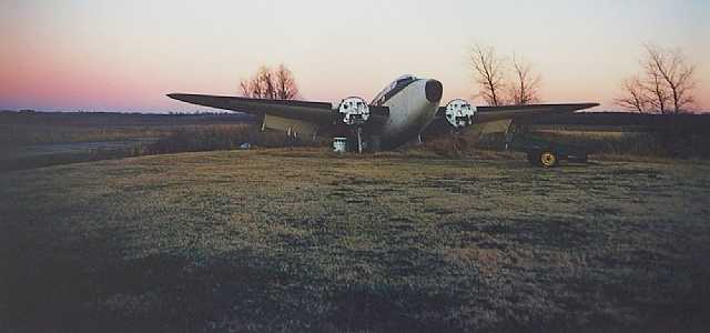
A 1974 photo of a Lockheed hulk at Twinkle Town Airport.

A circa 1970s aerial view looking north depicted Twinkle Town Airport perhaps at its zenith of popularity,
with a total of 15 single-engine aircraft parked around the hangar.
The 1985-86 TN Aeronautical Chart (courtesy of Alex Hauzer) depicted Twinkle Town as having a 3,800' unpaved runway.
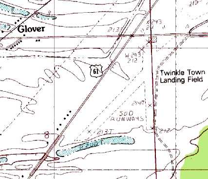
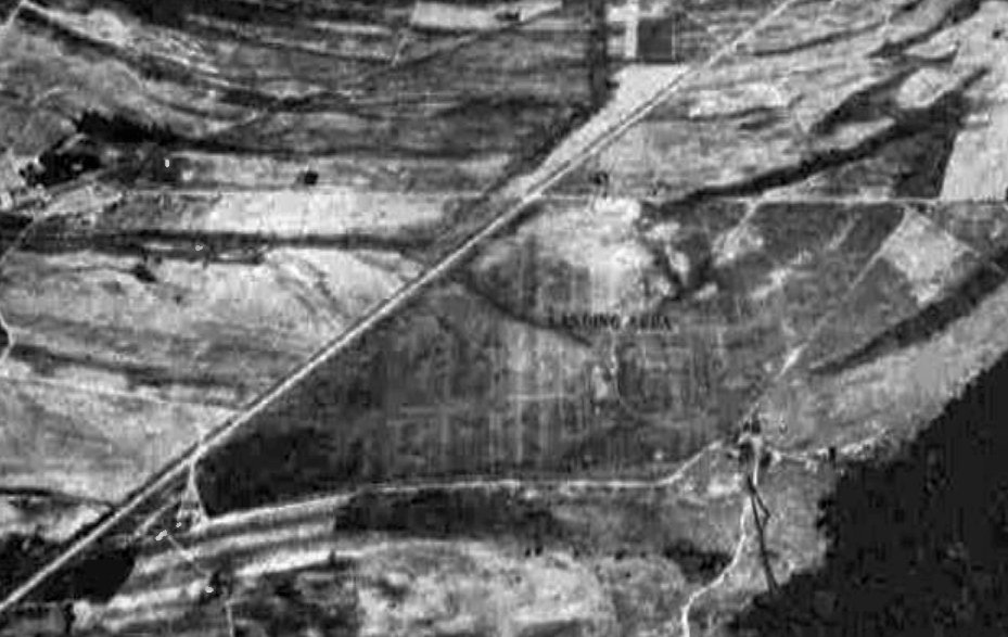
The 1988 USGS topo map depicted “Twinkle Town Landing Field”
as having 2 unpaved runways, with a single hangar on the north end.
G.M. Deedah recalled, “Twinkletown... when I was taking flying lessons we would go there to do touch & go's 26 years ago [1990].”
James Freeman recalled, “Twinkletown Airport was a beautiful little 'country' airport with 2 large, smooth turf runways & a large community hangar.
It was notable for having an ASR instrument approach (which I actually used once to get in in 1992).
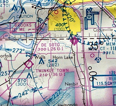
I believe the location is directly under the 'TWIKL' intersection, in Memphis Class B airspace.”
Tom Mathes recalled, “I have flown at Twinkletown & had a Cub there.
It had 2 runways, turf and a large hangar there. There was a VOR approach off of the Memphis VORTAC there.”
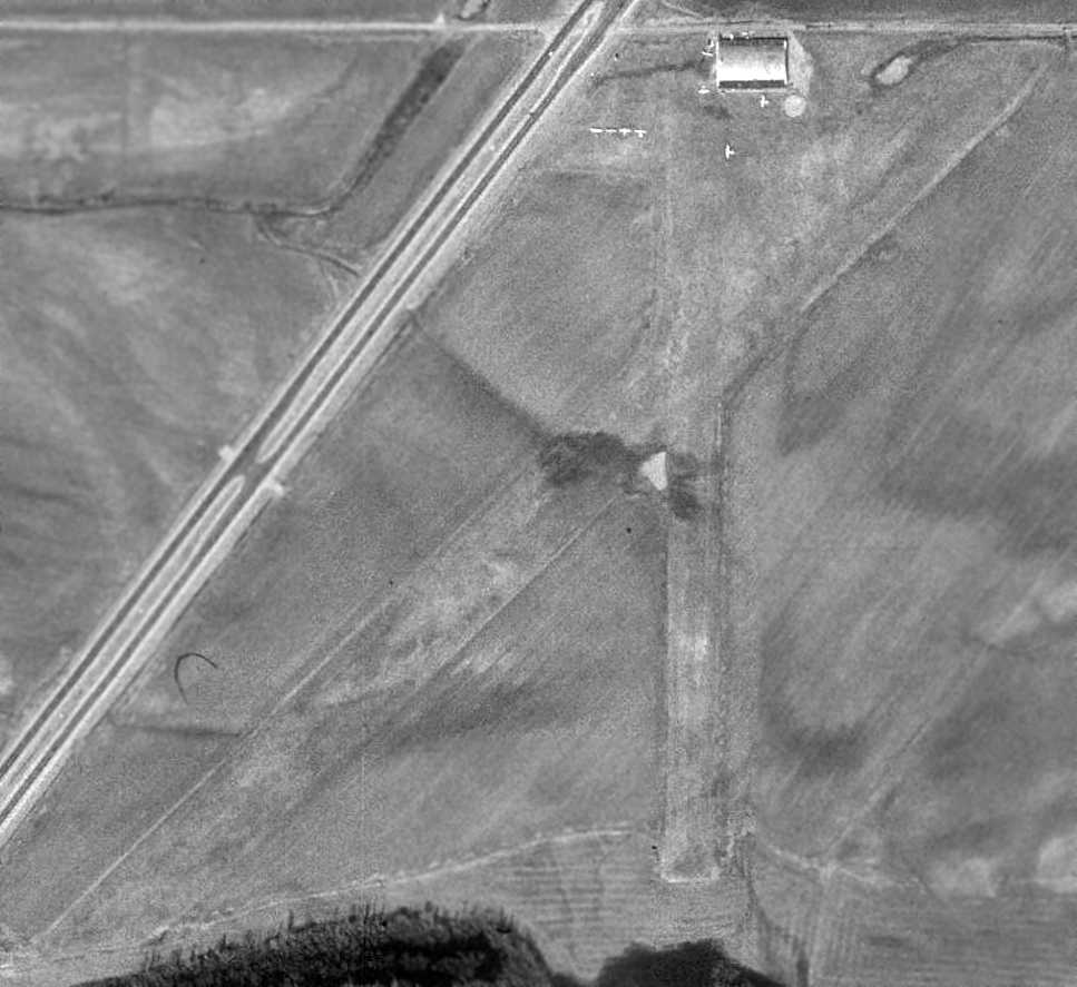
The last photo which has been located showing aircraft at Twinkle Town Airport was the 1/29/97 USGS aerial photo.
It depicted a total of 8 single-engine aircraft parked around the hangar on the north side of Twinkle Town.
The last aeronautical chart depiction which has been located of Twinkle Town Airport was on the April 1999 Memphis Terminal Aeronautical Chart (courtesy of Ron Plante).
It depicted Twinkle Town as having a 3,600' unpaved runway.
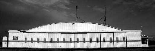
An undated photo of the Twinkle Town hangar.
According to James Freeman, Twinkle Town Airport “was closed when the expansion of the Tunica Airport was started.”
Jonathan Westerling reported, “Twinkle Town Airport was likely closed in 2000 as it was not listed in the 2001 AOPA Airport Directory.
According to Airspace Docket 02-ASO-26, the closure of Twinkle Town Airport caused the Memphis Class E airspace to be modified as of 1/23/03.
Note that the airport was closed well before the 2003 publication of this modification.”
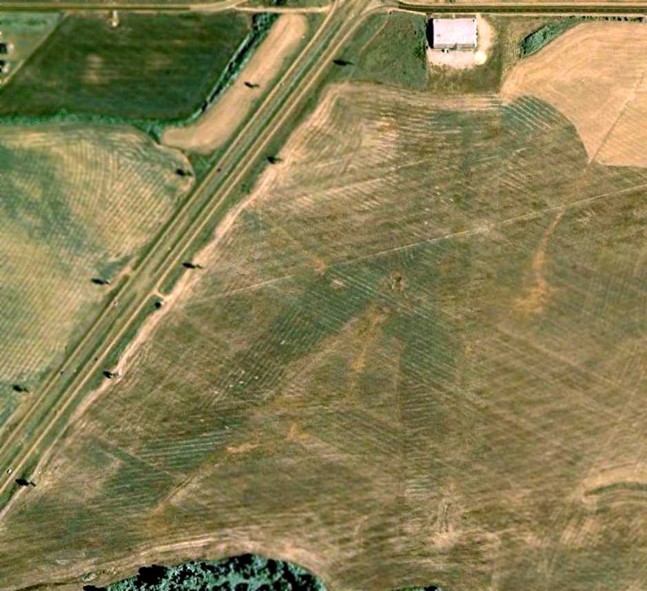
A 8/8/07 aerial view depicted Twinkle Town Airport as remaining intact, but appearing to be abandoned.
A circa 2004-2008 photo looking southeast at the Twinkle Town hangar.
A circa 2004-2008 aerial view looking north at the Twinkle Town hangar.

A 2008 photo of the Twinkle Town hangar being dismantled by ironworker David Hall.
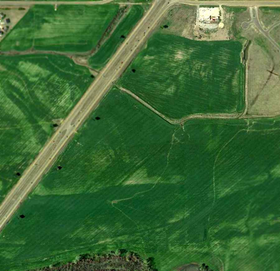
A 4/10/10 aerial view showed the airfield area at Twinkle Town remaining intact, but the hangar had been removed.
The site of Twinkle Town Airport is located southeast of the intersection of Route 61 & Church Road.
____________________________________________________
De Soto Airpark, Southhaven, MS
34.99, -90.03 (South of Memphis, TN)
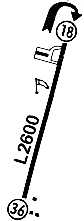
De Soto Airpark, as depicted on the July 1964 Little Rock Sectional Chart (courtesy of Chris Kennedy).
Photo of the airport while in operation is not available.
This general aviation airport was evidently established at some point between 1961-62,
as it was not yet depicted on a 1958 aerial photo nor on the February 1961 Little Rock Sectional Chart.
The earliest reference to De Soto Airpark was its listing in the 1962 AOPA Airport Directory (according to Chris Kennedy).
Andy Cotten recalled, “De Soto Airpark... This airport had a single North/South runway of approximately 2,200'.
I first flew off it in the summer of 1962 in an Ercoupe with my father.
It is special to me because it was where I flew I with my dad for the 2nd time in my life.”
The earliest photo which has been located of De Soto Airpark was a 1963 aerial photo.
It depicted the field as having a single asphalt north/south runway,
with 25 light aircraft parked around a hangar on the northwest side,
and another building (perhaps still under construction) on the southeast side.
The earliest aeronautical chart depiction which has been located of De Soto Airpark
was on the July 1964 Little Rock Sectional Chart (courtesy of Chris Kennedy).
It depicted De Soto as having a 2,600' paved runway.
Tom Gramlick recalled, “De Soto Airpark... My father introduced me to Mr. Pennington summer of 1965.
I received all my ratings at that airpark except the ATP because I was only 20 years old & the Army drafted me.
Mr. Collins & I flew many hours IFR training & I fell in love with that Cessna 310 B for the multi engine rating.
And that fun-to-fly Link Trainer. Those DC-3s were old Capital Airlines.
I flew many hours from Desoto Airpark even those night flights - I called that airport the Black Hole.
Landing to the north I would line up with Dover Elevator tower just east of me before I started my let-down because that was a good runway heading.
Remember there were no approach lights at that airport, only one hangar light on the south end then I saw the runway lights, get ready to land.
I even had an electrical problem one night & landed with no lights because the alternator failed.
I was reported by a neighbor near the airport to the FAA that this aircraft landed at midnight with no lights.
We all got a good laugh because in the log book of that Cessna 172 was listed no electrical & had to land without any lights; thank goodness it had manual flaps.
I also remember those night flights if you did not have the mains on the ground at the wind sock, GO AROUND.
I came back in 1970 to Desoto Airpark & rented airplanes a several times.”
Bill Starr recalled, “I remember the DC-3 that was there.
My sister soloed there in 1967 & I remember going to see her shirttail nailed to the wall in the FBO office.”
John Roberts recalled, “De Soto Airpark... My aviation career started here when my father kept a small plane there in 1968.
I was only 6 in 1968, but I would have lived at the airport if I could, and it was here that career seeds were planted.
Paul Crowder was the last owner, running a Mooney dealership.”
Marv Donnaud recalled, “Desoto Air Park... Very short runway but the owner was the best DC-3 pilot known to mankind.
He could land one there with runway to spare. His name was Charlie Pennington.
His partner was Walt Looney, the only person I ever knew who had 2 airplane crashes in one day.
The company that operated the DC-3 was Penlo Airways, a combination of their two last names.
My understanding is that Charlie flew a DC-3 for Air America in Viet Nam & that he died while he was over there.”
Andy Cotten recalled, “My copy of The Commercial Appeal 6-19-70, Flight Talk by Olivia Browne,
has a story pertaining to the new president of the airport.
It goes on to say John Cochran is only 27 & had been managing the airport since its sale in May by Walt Looney.
Bill Gray was the maintenance department manager & was Vice president.
Chuck Collison is the chief pilot & CFI.
Several instructors were on staff including Billy Paul, David Sims, Jim Weddell, Norman Pyles, Bill Herrin, Sam Rhodes, and Frank James.
So it was quite an active airport in 1970.”
A 1971 aerial photo depicted a total of 14 aircraft at De Soto Airpark, including a DC-3.
A 2nd building had been added on the southeast side at some point between 1963-71.
Andy Cotten recalled, “De Soto Airpark... I later flew into there in a L-16 in 1972.
My last flights were in Cessna 150s in early 1973. Walt Looney with Penlo ran the airport in those days.
Joe Hopkins & Jim Weddell were still instructing there when I rented aircraft in 1973.
I also remember there were power lines just off the departure end of the north runway that had the big orange balls on them.”
The last aeronautical chart depiction which has been located of De Soto Airpark
was on the November 1974 Memphis Sectional Chart (courtesy of Ron Plante),
which depicted De Soto as having a 2,600' paved runway.
Thawk74T recalled, “De Soto Airpark... I know it was active up until sometime in the mid-1970s.
It consisted of a single north-south paved runway & a small flight school.”
Bob Cook recalled, “I never knew there was an airport there until they ran some car drag races there in 1977-78 until the FAA shut that down.”
The 1978 USGS topo map depicted a “Private airfield” with a single short unpaved north/south runway,
and a few small buildings on the north side.
The July 1979 Flight Guide (courtesy of Chris Kennedy) depicted De Soto Airpark
as having a single 2,600' paved Runway 18/36,
with a ramp & hangar at the northwest corner, and 3 small buildings on the southeast corner.
The last directory listing which has been located for De Soto Airpark was in the 1980 AOPA Airport Directory (according to Chris Kennedy).
The directory described De Soto as “Private, use at own risk.”
De Soto Airpark may have been closed at some point between 1980-82,
as it was no longer listed among active airfields in the 1982 AOPA Airport Directory (according to Chris Kennedy).
Tom Gramlick recalled, “Years later we would pass over the old airport that was not there any more.
The first I noticed it had Xs on each end of the runways & later things were all grown up & could not really see it, in the 1980s.”
De Soto Airpark was depicted as an abandoned airfield on the 1987 Memphis Sectional Chart.
The 1988 USGS topo map depicted the runway & several buildings at the site of De Soto Airpark, labeled simply as “Landing Strip”.
A 3/1/96 USGS aerial view looking northwest showed the De Soto Airpark runway remained intact but deteriorated,
and one hangar remained standing on the northwest side, and 3 other hangars remained standing on the southeast side.
A 2/12/03 aerial view showed that the hangar on the northwest side had been replaced at some point between 1996-2003 by several buildings,
and a large building had been constructed over the center of the runway during the same timeframe.
A circa 2006-2010 aerial view looking east at 3 former hangars which remain standing, on the southeast side of the remains of the De Soto Airpark runway.
A 2016 aerial view looking northwest shows the site of De Soto Airpark being unrecognizable from the air as a former airport,
with the runway being heavily overgrown, and the 3 former hangars on the southeast side (bottom-left) hidden by trees.
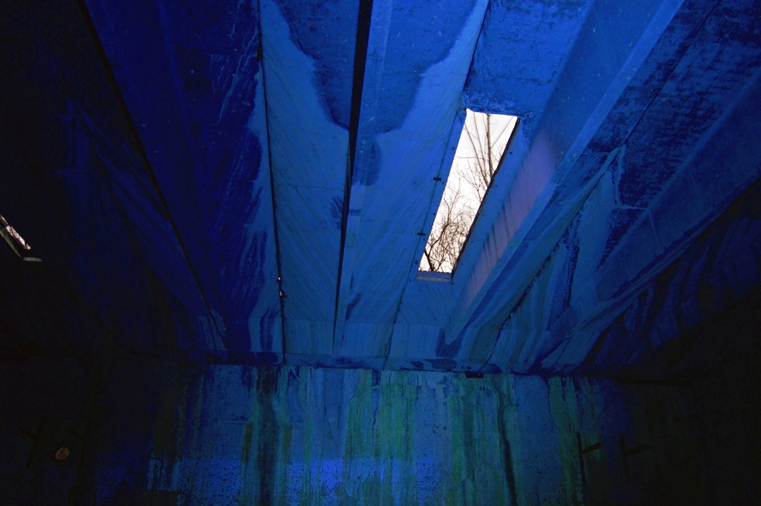
A 1/19/16 photo of the interior of a former De Soto Airpark hangar.
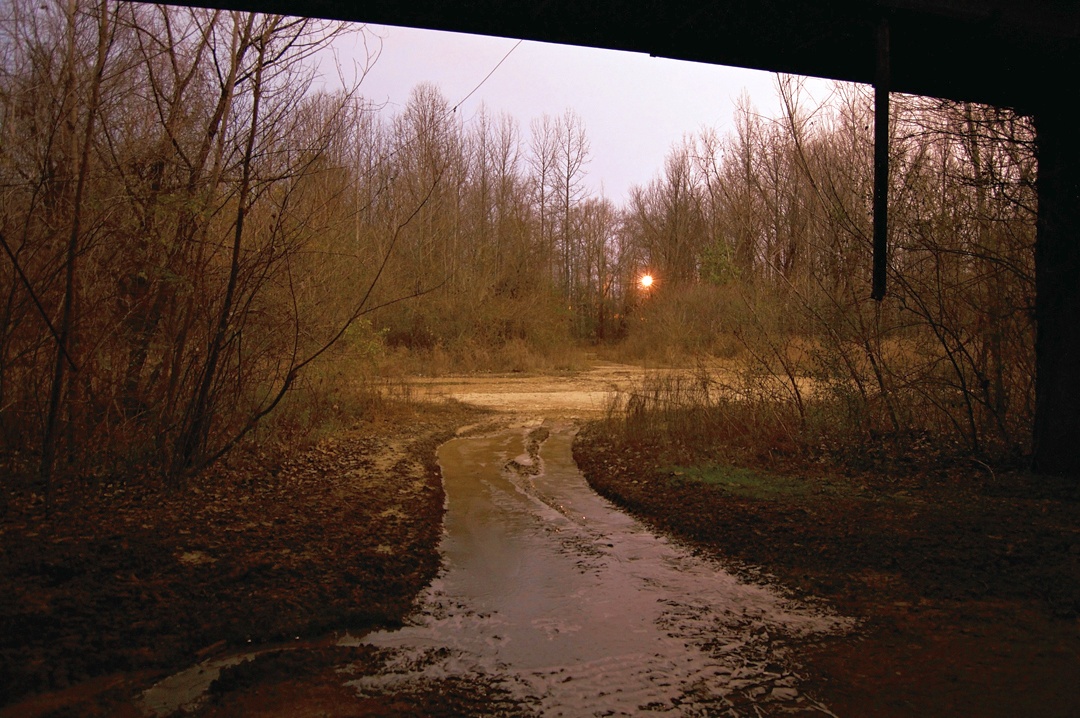
A 1/19/16 photo looking out from a former De Soto Airpark hangar.
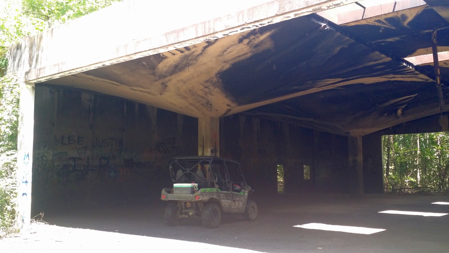
A 7/30/17 photo by Tommy Johansen of the interior of the northeastern-most hangar at the site of De Soto Airpark.
Tommy Johansen reported, “As of today, three hangars still stand & the runway is mostly intact... albeit overgrown with vegetation.
I can attest that this is still a very busy place on the weekends, although the traffic is no longer airplanes... just ATVs & UTVs.”
The site of De Soto Airpark is located southeast of the intersection of Stateline Road West & Stanton Road.
____________________________________________________
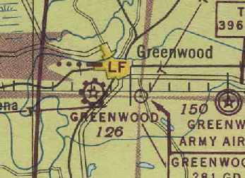
Greenwood Municipal Airport / Le Flore Airport, Greenwood, MS
33.5, -90.2 (South of Memphis, TN)
Greenwood Municipal Airport, as depicted on the 1934 Shreveport Sectional Chart.
Greenwood's original Municipal Airport was located adjacent to the southwest side of the town.
The date of construction of the airfield has not been determined.
The earliest reference to the field which has been located
was in The Airport Directory Company's 1933 Airport Directory (courtesy of Chris Kennedy).
It described Greenwood Municipal Airport as being located "1/2 mile south of city limits",
and the field was said to have 2 sod runways: 2,960' & 2,800' long.
The earliest depiction which has been located of Greenwood Municipal Airport was on the 1934 Shreveport Sectional Chart.
It depicted Greenwood as a commercial/municipal airport.
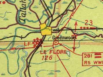
The July 1938 Shreveport Sectional Chart (courtesy of Chris Kennedy) labeled the field as "Le Flore" Airport.
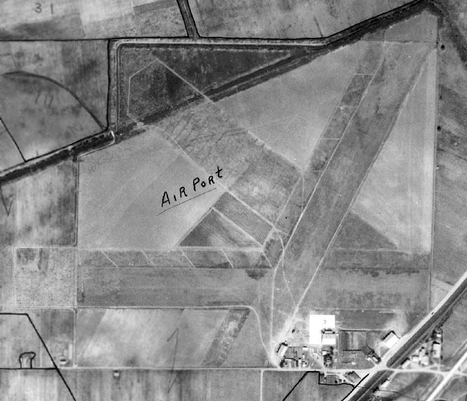
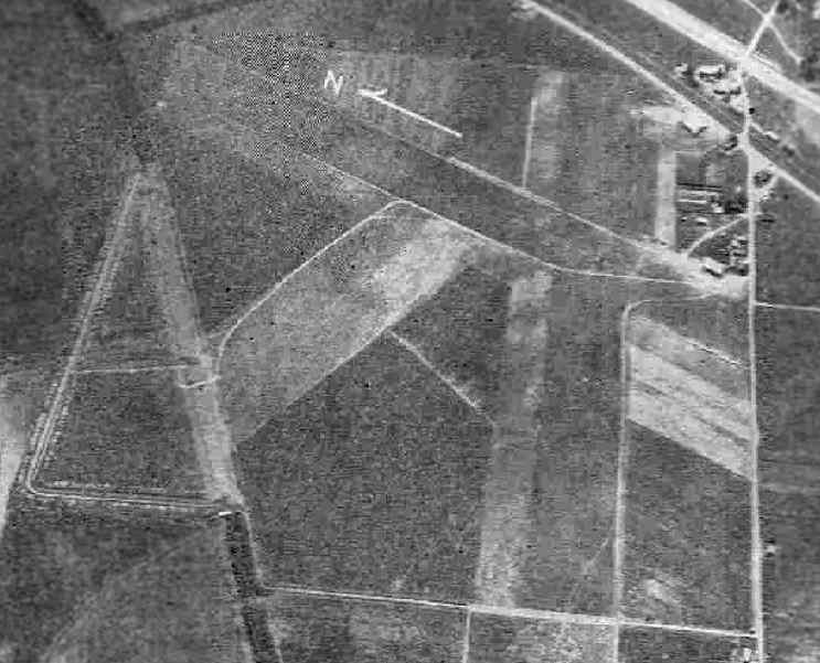
A 10/25/38 aerial view (courtesy of Allan Hammons) showing Greenwood's 3 grass runways.
A ramp, hangar, and a few other small buildings were visible on the southeast side of the field.
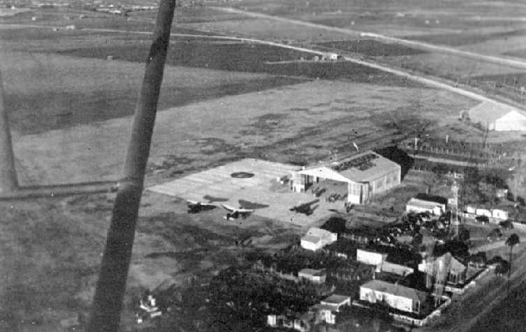
A circa 1940 aerial view looking northeast at Greenwood's hangar & ramp (courtesy of Allan Hammons).
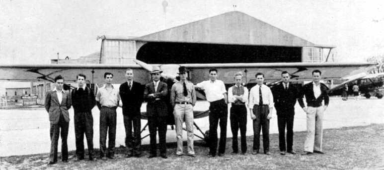
A circa 1940 photo of the staff of Greenwood Flying Service,
which conducted flight instruction, crop dusting, and airplane sales (courtesy of Allan Hammons).
An aerial view looking northeast at the Le Flore County Municipal Airport
from The Airport Directory Company's 1941 Airport Directory (courtesy of Chris Kennedy).
It described the field as having 3 sod runways, with the longest being the 3,150' northwest/southeast strip.
A hangar was pictured at the southeast corner of the field.
Allan Hammons recalled, "Prior to World War II, a Civilian Pilot Training program was established
in conjunction with nearby Sunflower Junior College to provide initial flight training for the military.
As war came, the Army selected a site 6 miles east of Geenwood Municipal Airport
for a Basic Flying School to be known as Greenwood Army Air Field.
During the construction of GAAF, the Army also constructed three 4,000' runways at Greenwood Municipal.
The airport was used as an auxiliary field by the Army."
According to Allan Hammons, the three 4,000' runways were built by the Army in 1942.
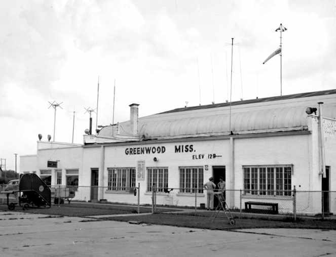
A 1943 photo (courtesy of Allan Hammons) of Greenwood's main hangar & terminal building (reused as of 2004 by Abraham Trucking).
"The window on the right was the airport manager's office, the center 2 windows were the terminal
and the area on the left was the Civil Aeronautic Administration's Greenwood Radio (Flight Service Station)."
The field was apparently renamed back to "Greenwood" by 1944,
as that is how it was listed in the April 1944 US Army/Navy Directory of Airfields (courtesy of Ken Mercer).
It also had been paved, as it was said to have a 4,000' hard-surface runway,
and Army flight operations were said to be conducted from the field.
The 1944 directory also listed the newly-constructed Greenwood AAF,
which had been constructed 5 miles to the east (and would eventually replace the original Greenwood Airport years later).
"Greenwood" Airport, as depicted on the April 1945 Shreveport Sectional Chart (courtesy of Chris Kennedy).
The 1945 AAF Airfield Directory (courtesy of Scott Murdock) described Greenwood Municipal Airport
as a 257 acre irregularly-shaped property having three 4,000' asphalt runways.
The field was said to have 2 hangars, the largest being a 100' x 80' steel structure.
Airline service was provided by Chicago & Southern Airlines, and the field was also said to have Army activity.
The airport was described as being owned & operated by the City of Greenwood.
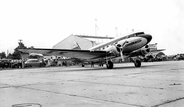
A 1947 photo (courtesy of Allan Hammons) looking southwest from the ramp toward Greenwood's terminal and a Chicago & Southern DC-3.
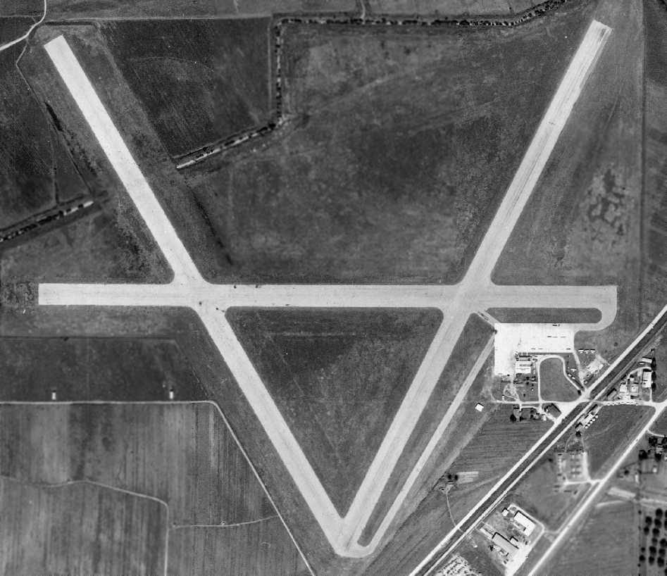
A 1950 aerial view (courtesy of Allan Hammons) showing Greenwood's 3 paved runways.
A ramp, hangar, and several light aircraft were visible on the southeast side of the field.
The 1950 Shreveport Sectional Chart depicted Greenwood Municipal Airport as having a 4,100' paved runway.
Allan Hammons recalled, "I learned to fly at the former Greenwood Municipal Airport.
The airport was served by Chicago & Southern with Lockheed Electras and later DC-3s.
In the 1950s, Delta acquired Chicago & Southern and the airport was served by Delta Convairs."
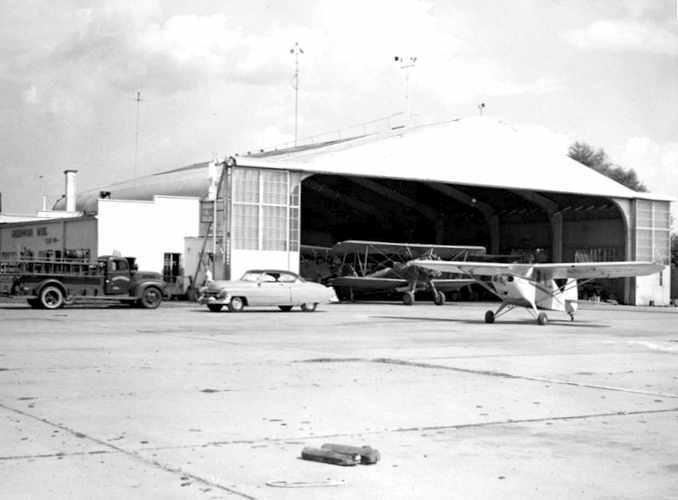
A 1952 photo (courtesy of Allan Hammons) showing the west doors of the municipal hangar, which was leased to Leflore Flying Service.
"The Cadillac belonged to the lineboy – [he was] independently wealthy."
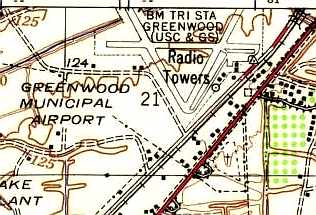
Greenwood Municipal Airport, as depicted on the 1957 USGS topo map, from the University of AL Map Library.
According to Chris Balducci, "A Greenwood native told me he remembered seeing aircraft from the old Southern Airways use that airport."
Allan Hammons recalled, "The field was home to major agricultural operations by locally owned Leflore Flying Service & Delta Airlines.
More than 20 Stearmans were based there.
Two Fixed-Base Operators operated there in the mid-1960s: Archer Aviation & Emerich Aviation.
The last [airline] service for the field before closing was by Southern Airlines with DC-3s."
The 1967 AOPA Airport Directory (courtesy of Chris Kennedy) described Greenwood Municipal as having three 4,000' asphalt runways: 9/27, 4/22, and 13/31.
The field was said to offer fuel, repairs, hangars, and charter.
The operators were Arrow Aviation, Emrich Flying Service (a Cessna dealer), and Leflore Flying Service.
The last aeronautical chart depiction which has been located of the original Greenwood Municipal Airport was on the June 1968 Shreveport Sectional Chart.
It depicted Greenwood Municipal Airport as having 3 paved runways; the longest being 4,000'.
The original Greenwood Municipal Airport evidently closed at some point between 1967-71,
as it was not listed in the 1971 Flight Guide (according to Chris Kennedy).
In that directory, the former Greenwood AAF to the east was listed as Leflore Airport.
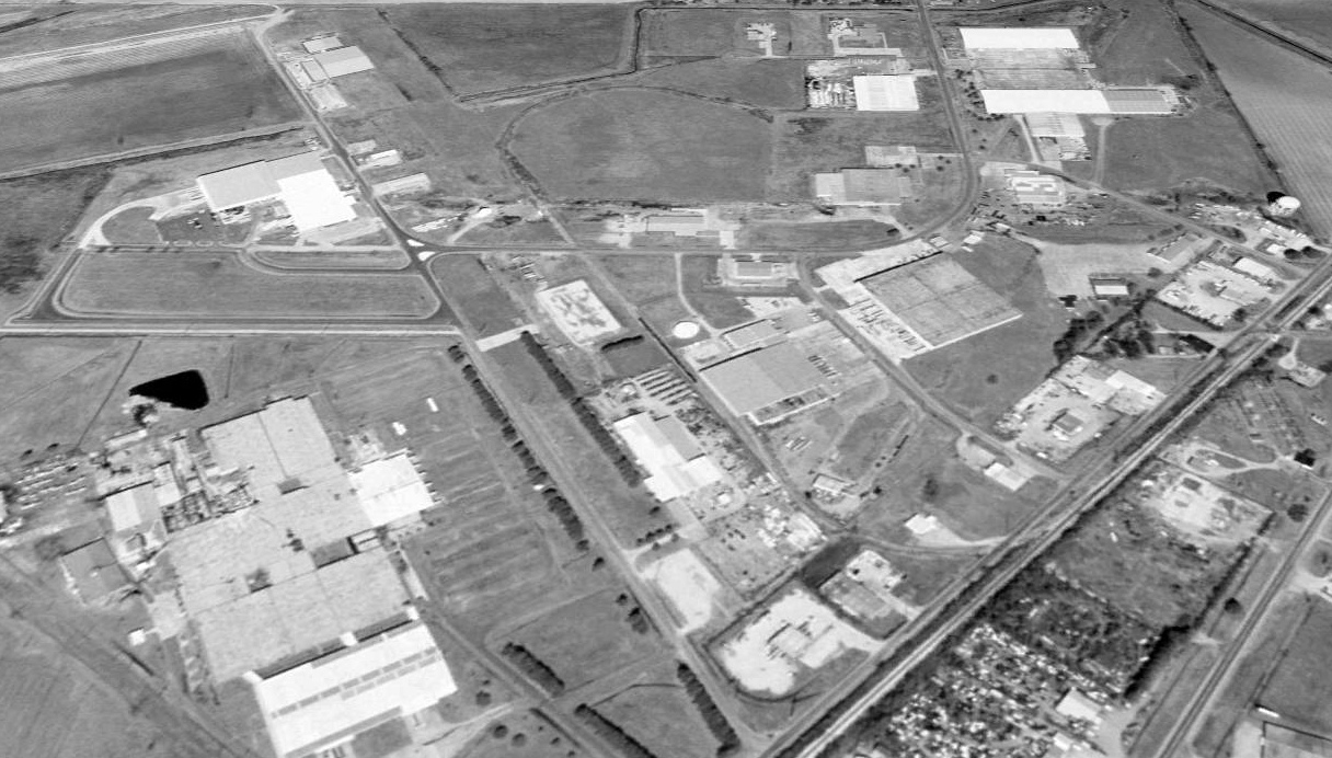
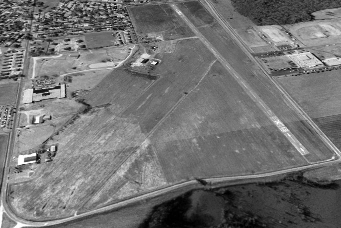
A 1996 USGS aerial view looking north showed the site of Greenwood Municipal Airport has been covered by a number of larger buildings.
However, traces of 2 runways were still evident, including the outline of almost the entire northwest/southeast runway.
Chris Balducci reported in 2004, "I've been to Greenwood many times.
It wasn't until last year that I discovered the old airport existed where the Greenwood-Leflore Industrial Park is now.
After several subsequent trips to Greenwood, I found an old hangar that now houses the Abraham Trucking Company.
Otherwise, the developers of the industrial job did a 'good job' covering up the remnants of the old airport."
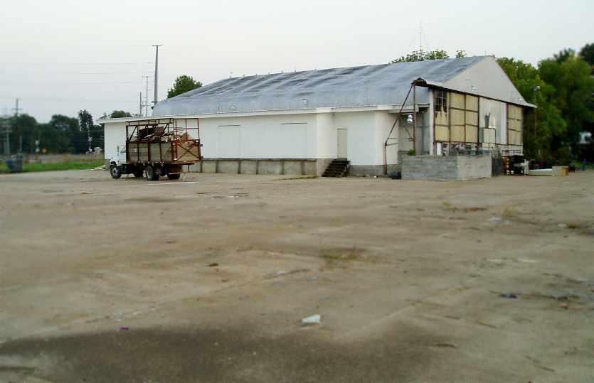
A 2006 photo by John Wienand of the 1940-vintage hangar which remains at the site of Greenwood Airport.
According to John, this was “the only airport building I could identify on site.
The entire area has been rebuilt & developed as an industrial park. There are several closed businesses out there.
The runways are gone, all traces. Only the big concrete ramp by the hanger exist today.
Abrahams Trucking has the site listed for sale.”
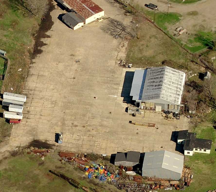
A circa 2006 aerial view looking east at the hangar which remains standing at the site of the original Greenwood Municipal Airport.
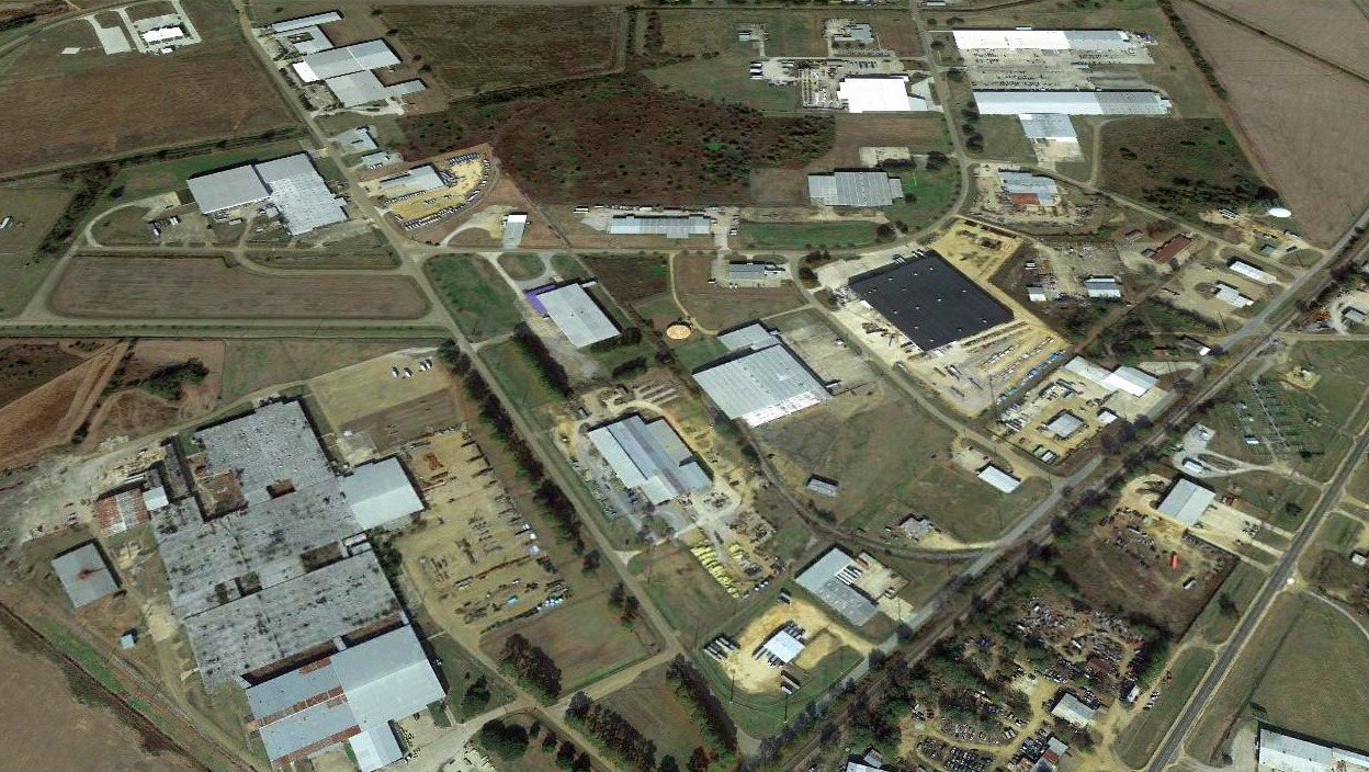
A 2017 aerial view looking north at the site of Greenwood Municipal Airport showed the alignment of 2 runways were still evident.
The site of the original Greenwood Municipal Airport is located west of the intersection of Route 49E & Route 175.
____________________________________________________
Yazoo City Municipal Airport / Barrier Airport (M09), Yazoo City, MS
32.88, -90.41 (North of New Orleans, LA)
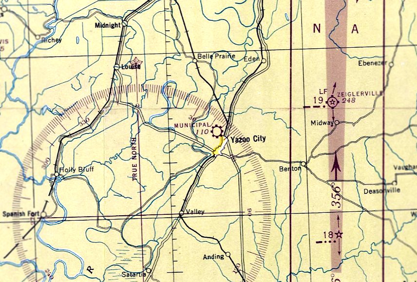
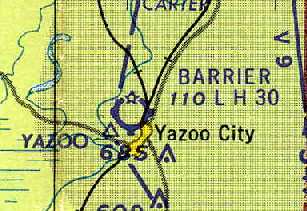
Yazoo City Airport, as depicted on the April 1947 Shreveport Sectional Chart.
This general aviation airport was apparently built at some point between 1946-47,
as it was not yet depicted on the September 1946 Shreveport Sectional Chart.
The earliest depiction which has been located of Yazoo City Municipal Airport was on the April 1947 Shreveport Sectional Chart.
It depicted Yazoo City "Municipal” as a commercial/municipal airport.
Yazoo City Municipal Airport was apparently renamed Barrier Airport at some point between 1949-60,
as that is how it was labeled in the 1960 Jeppesen Airway Manual (courtesy of Chris Kennedy).
It depicted the Barrier Airport as having a 3,000' paved Runway 17/35 & a 2,904' unpaved Runway 4/22,
along with 2 buildings (hangars?) on the south side of the field.
"Barrier Airfield" was depicted as having a single north/south runway & a few buildings on the east side of the field,
on the 1961 USGS topo map (from the University of Alabama Map Library).
The June 1961 Boston Mountains World Aeronautical Chart (courtesy of Chris Kennedy)
depicted Barrier Airport as having a 3,000' hard-surface runway.
According to Gale Johnson recalled, “In the early 1960s, Delta Airlines was operating DC-6 & DC-7 aircraft
into and out of the Jackson MS Municipal Airport (Hawkins Field)
and it's location to the city of Jackson was about the same as Barrier Airport was to Yazoo City.
It was night time, and the pilots mistook Barrier for Hawkins & landed.
The aircraft was flown out after everything that could be removed to make it lighter was taken out.”
The 1976 AOPA Airport Directory (according to Chris Kennedy)
listed the operator of Barrier Airport as the George Clanton Dusting Company.
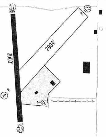
The 1985 Flight Guide (courtesy of Chris Kennedy) depicted Barrier Airport as having a single 3,660' paved Runway 17/35,
along with a closed grass runway extending northeast from the center of the field.
A taxiway led to a ramp on the east side of the runway,
around which were situated 4 buildings (hangars?).
According to David Richardson, “Barrier Field... was closed in the late 1980s.
The reason was to build a larger field outside of town that could accommodate small jets.
Yazoo City High School [had been built in 1978] several hundred yards away from the old field,
and there was no room to extend the runway.”
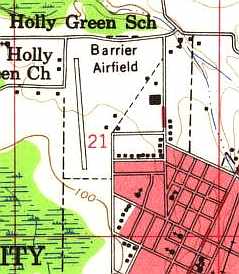
The closed Barrier Airport was still completely intact as of a 1996 USGS aerial view looking south,
although the paved runway was marked with closed runway "X" symbols.
Several hangars remained standing, and the airfield appeared to remain basically intact.
David Richardson reported in 2005, “The old field has now been transformed into a city park
that includes many facilities including a driving range.”
A circa 2006 aerial view looking north at several former hangars which remain standing on the east side of the site of Barrier Airport.
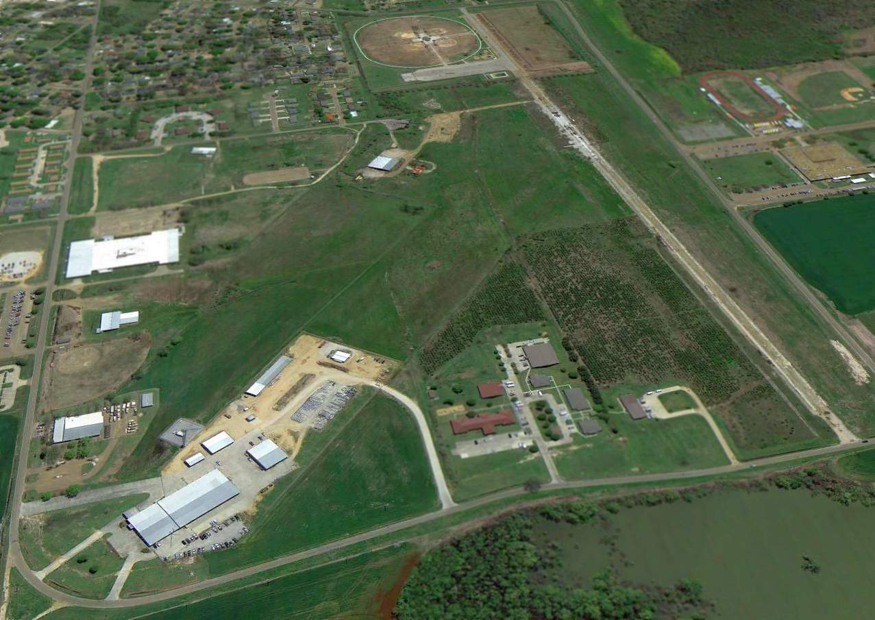
A 2014 aerial view looking south at the site of Barrier Airport showed the paved Runway 17/35 remained intact,
though the southern portion had been reused as a parking lot for a complex of baseball fields.
Two hangars remained standing on the east side,
but a new complex of buildings had been added at some point between 1996-2014 on the northeast end of the former grass Runway 4/22.
The site of Barrier Airport is located northwest of the intersection of Gordon Avenue & Hugh J McGraw Road.
____________________________________________________
Greenville Municipal Airport / Greenville Army Airfield Auxiliary #1, Greenville, MS
33.39, -91 (West of Birmingham, AL)
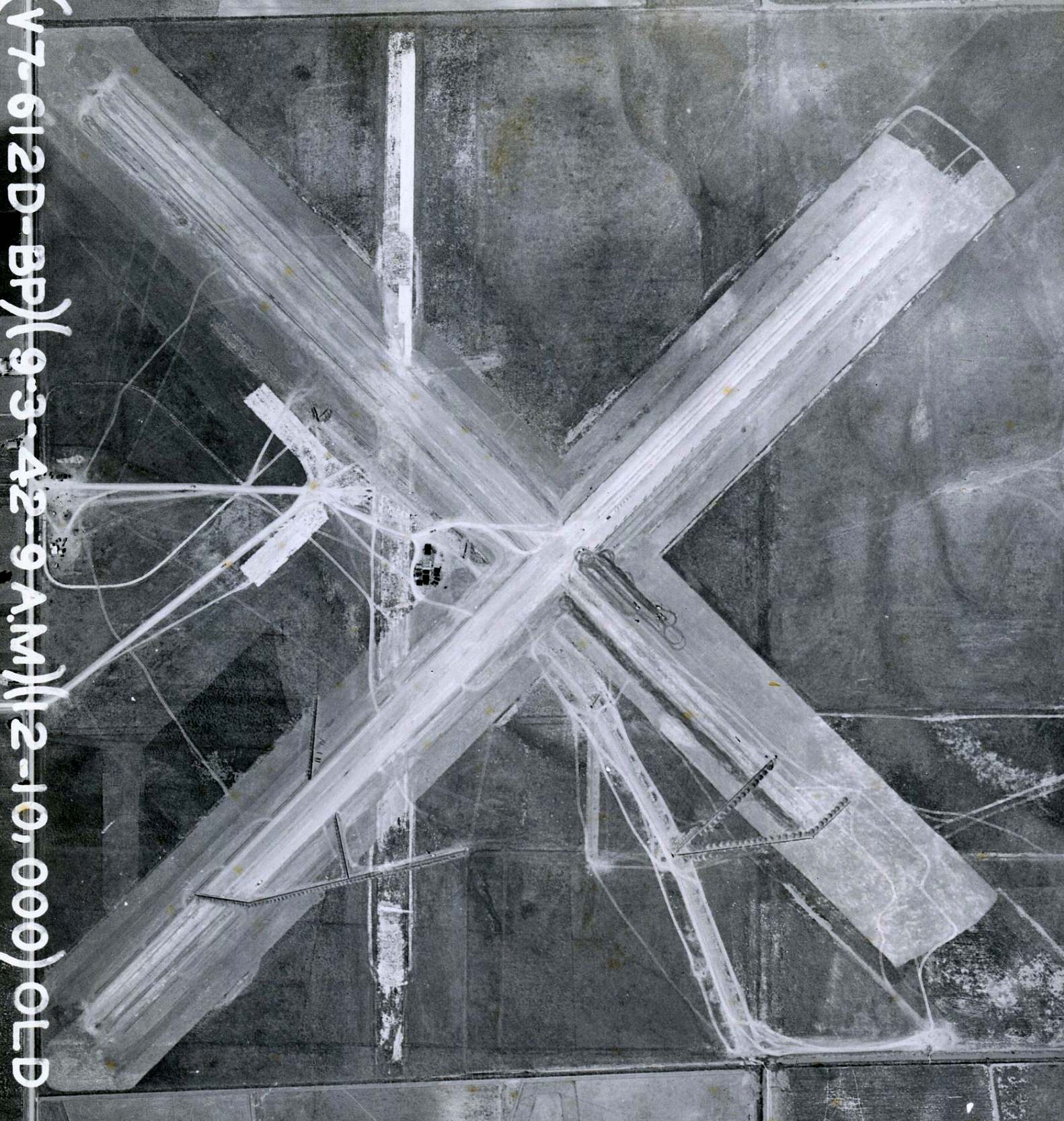
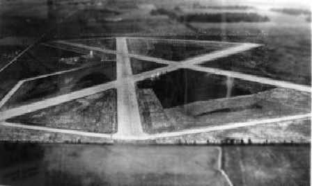
A 9/3/42 USAAC aerial view of the “Old Mun. Airport, Aux Field, Greenville MS” (National Archives pic, courtesy of David Upton).
Greenville Airport was not yet depicted on the 1942 Shreveport Sectional Chart.
Greenville Airport was used during WW2 as one of 5 satellite airfields for Greenville AAF (6 miles northeast),
which conducted training as part of the 30,000 Pilot Training Program.
The earliest depiction which has been located of the Greenville Airport was a 9/3/42 USAAC aerial view
of the “Old Mun. Airport, Aux Field, Greenville MS” (National Archives pic, courtesy of David Upton).
It depicted 3 paved runways & a ramp on the west side under construction.
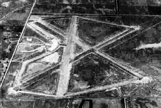
A 6/1/43 aerial view looking north at “Greenville AAF Auxiliary #1 (Greenville Municipal Airport)”
from the 1945 AAF Airfield Directory (courtesy of Scott Murdock).
It depicted the field as having 3 paved runways, taxiways, and a ramp on the west side.
The earliest aeronautical chart depiction which has been located of Greenville Municipal Airport was on the November 1944 Shreveport Sectional Chart (courtesy of Ron Plante).
It depicted “Greenville (Aux)” as a civilian airport.
The 1945 AAF Airfield Directory (courtesy of Scott Murdock) described “Greenville AAF Auxiliary #1 (Greenville Municipal Airport)”
as a 411 acre irregularly-shaped property having 3 asphalt runways, the longest being the 4,000' northwest/southeast & northeast/southwest strips.
The field was not said to have any hangars,
to be owned by the City of Greenville, but operated by the Army Air Forces.
At some point between 1945-50 it reverted to being used as the Greenville Municipal Airport.
The last aeronautical chart depiction which has been located of Greenville Municipal Airport was on the 1950 Shreveport Sectional Chart,
which depicted Greenville as a civilian airport having a 4,000' paved runway.
A 1952 aerial view looking north at Greenville Airport (courtesy of the Greenville AFB Museum, via Ron Plante).
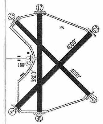
The 1959 Jeppesen Airway Manual (courtesy of Chris Kennedy)
depicted Greenville Airport as having 3 paved runways, with the 4,000' Runways 13/31 & 4/22 being the longest.
Several buildings (hangars?) were depicted along the west side of the field.
Greenville Municipal was described in the 1962 AOPA Airport Directory
as having 3 paved runways, and the operator listed as Valley Flying Service.
The Greenville Municipal Airport was apparently closed at some point between 1962-67,
as all 3 runways were marked with closed “X” symbols on a 1967 aerial photo.
The airport & all of its infrastructure otherwise remained intact.
It had been replaced by the larger Greenville AAF, which had been closed by the military & became the new Greenville Airport.
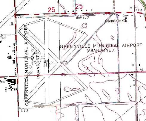
It was labeled “Greenville Municipal Airport (Abandoned)” on the 1970 USGS topo map.
The 1972 Flight Guide (according to Chris Kennedy) only listed the new airport.
The site of the original Greenville Airport was depicted as an abandoned airfield
on the 1973 Memphis Sectional Chart (courtesy of Robert Brown).
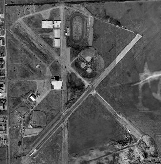
As seen in the 1996 USGS aerial photo,
the original Greenville Airport property has been reused as a municipal recreation complex,
as a track & several baseball diamonds had been built on the north side of the runways,
which were still largely intact.
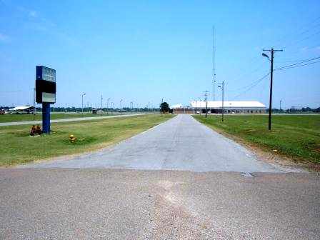
A 2006 photo by Ron Plante looking east at the former main entrance of the Greenville Airport,
with the convention center in the background.
Ron Plante visited the site of Greenville Airport in 2006.
He reported, “The old Municipal Airport is known as Washington County Park,
a recreational complex with baseball fields, livestock pens, and a drag strip.
Also there is the Washington County Convention Center, which is on the site of the old operations building.
All 3 runways are intact, although some are more gravel than asphalt. I did not see any hangars.”
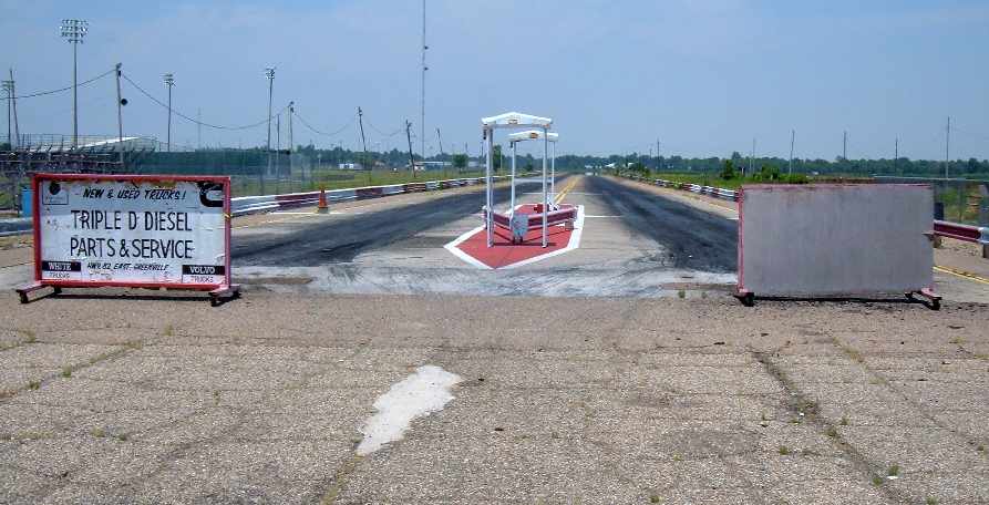
A 2006 photo by Ron Plante looking northeast along the drag strip which occupies the former Greenville Airport Runway 4 approach end.
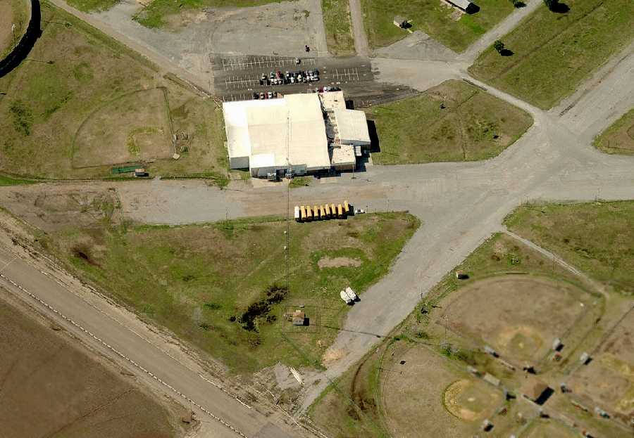
A circa 2006 aerial view looking west at former Greenville Airport runways & ramp pavement.
____________________________________________________
Since this site was first put on the web in 1999, its popularity has grown tremendously.
If the total quantity of material on this site is to continue to grow,
it will require ever-increasing funding to pay its expenses.
Therefore, I request financial contributions from site visitors,
to help defray the increasing costs of the site
and ensure that it continues to be available & to grow.
What would you pay for a good aviation magazine, or a good aviation book?
Please consider a donation of an equivalent amount, at the least.
This site is not supported by commercial advertising –
it is purely supported by donations.
If you enjoy the site, and would like to make a financial contribution,
you
may use a credit card via
![]() :
:
Please consider checking the box to make a monthly donatation.
For a mailing address to send a check, please contact me at: paulandterryfreeman@gmail.com
If you enjoy this web site, please support it with a financial contribution.
please contact me at: paulandterryfreeman@gmail.com
If you enjoy this web site, please support it with a financial contribution.
____________________________________________________
This site covers airfields in all 50 states.