Abandoned & Little-Known Airfields:
Maryland, Montgomery County
© 2002, 2023 by Paul Freeman. Revised 7/2/23.
This site covers airfields in all 50 states: Click here for the site's main menu.
____________________________________________________
Please consider a financial contribution to support the continued growth & operation of this site.
Congressional Airport (revised 7/2/23) - Gude Airport (revised 10/29/22) - Turbo-Porter Field (revised 9/19/21)
____________________________________________________
39.11, -77.15 (Northwest of Washington, DC)
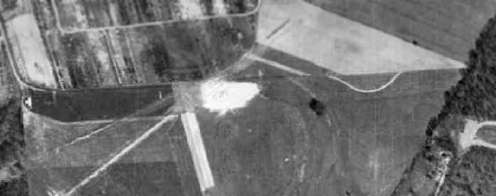
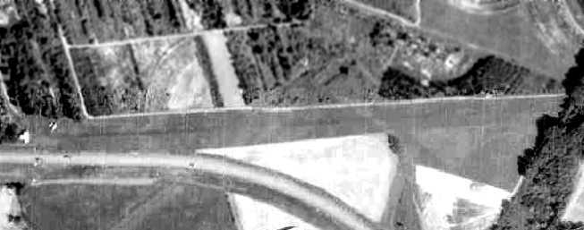
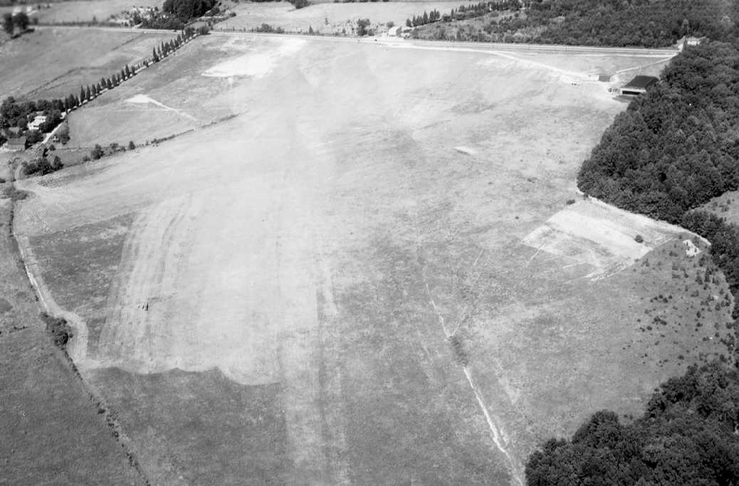
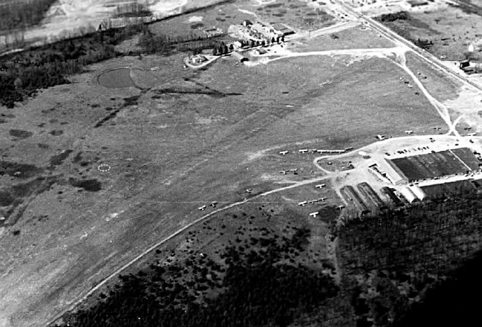
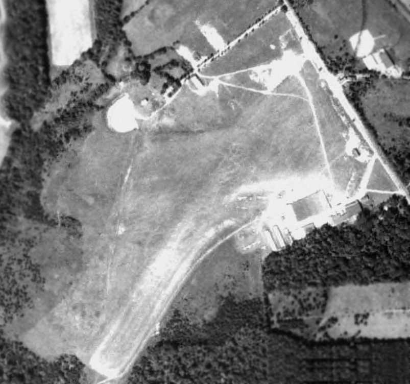
A 1957 aerial photo of Gude Airport depicted the field as having a single grass east/west runway,
with a single T-hangar at the west end.
What appeared to be 2 other “runways” running northeast/southwest were actually much longer features running through the property (perhaps pipelines?).
This small private airfield was evidently established at some point between 1951-57,
as it was not yet depicted at all on an early Fall 1951 aerial photo (courtesy of Chris Kennedy),
the 1956 Washington Local Aeronautical Chart (courtesy of Tim Zukas), or the 1956 USGS topo map.
The earliest depiction which has been located of Gude Airport was a 1957 aerial photo.
It depicted the field as having a single grass east/west runway, with a single T-hangar at the west end.
What appeared to be 2 other “runways” running northeast/southwest
were actually much longer features running through the property (perhaps pipelines?).
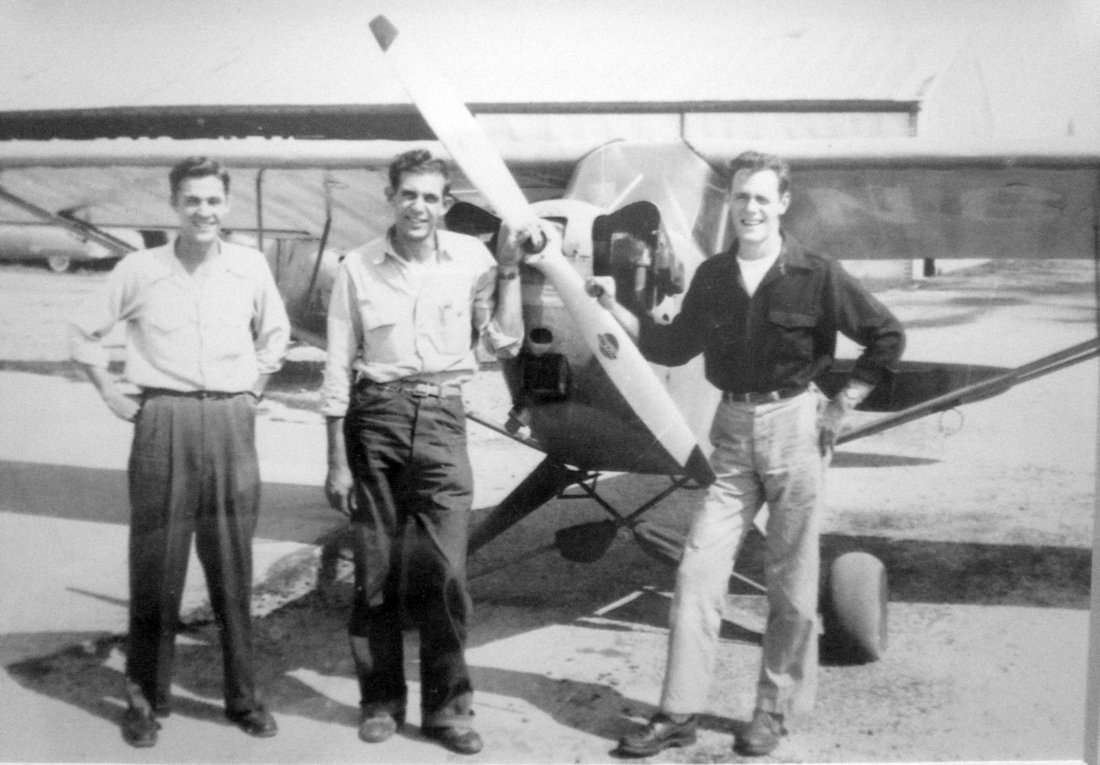
Judy Perine Taylor recalled, “Adolph Gude, Jr. & my dad, Jack Perine were best friends.
Dolph kept his plane at the airfield & my Dad was a partner with him. My father was a very experienced pilot & probably did the maintenance & upkeep on the plane.
My dad took me for a flight from that field using their airplane.”
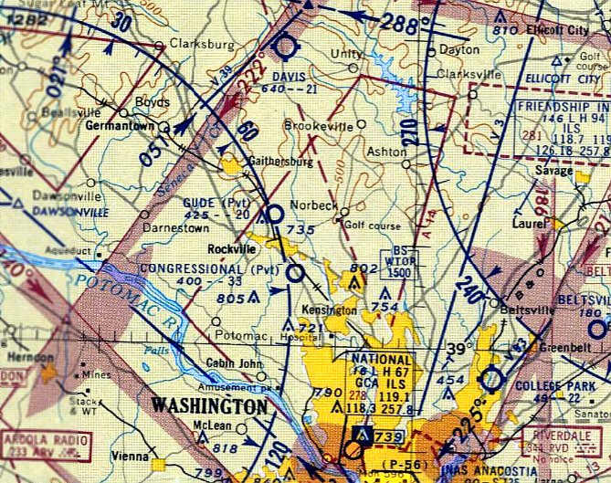
The earliest aeronautical chart depiction which has been located of Gude Airport was on the February 1957 Washington Sectional Chart.
It depicted Gude as a private airfield with a 2,000' unpaved runway.
According to Chris Kennedy, "It was owned by Gude Nurseries.
I remember driving by it numerous times when I used to live around there [from 1958-74]."
The February 1960 Washington Local Aeronautical Chart depicted Gude as a private airfield having a 2,000' unpaved runway.
The 1962 AOPA Airport Directory described Gude as an unattended airfield having a single 2,000' sod Runway 9/27.
There was no mention of it being a private airfield.
According to George Speake, "My grandfather was Adolph Gude
and was the owner of Gude & Sons Nursery, Inc., and therefore the Gude Airport as you have called it.
We never did call it that, instead referring to it as 'the airstrip at the nursery'."
Merton Meade recalled, “Dolph Gude's strip was nice.
It seems he kept his Travel Air there. A 'real' Travel Air, that is, not the Beechcraft twin.”
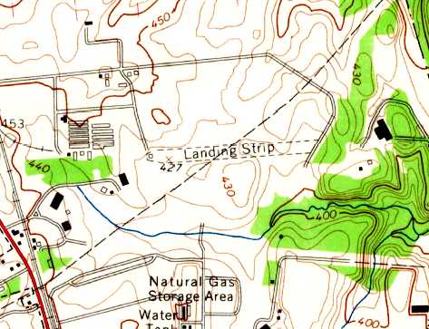
The 1965 USGS topo map depicted Gude Airfield as consisting of a single unpaved east/west runway,
labeled simply as “Landing Strip”.
The 1967 AOPA Airport Directory (courtesy of Chris Kennedy) described Gude as a "Private airstrip closed to public",
with a single 2,000' sod Runway 9/27.
According to Jerry McCauley, “I remember the T-shaped hangar & grass strip
being very close to the north edge of Gude Drive, a major county road built in 1968.”
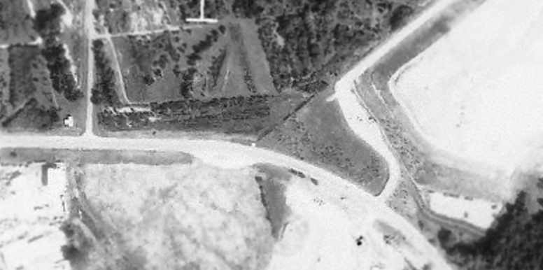
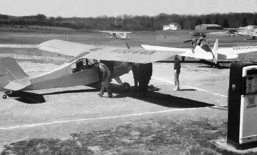
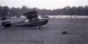
A 1970 aerial photo of Gude Airport (courtesy of Jerry McCauley), showing a single light aircraft on the west side of the field.
Jerry noted, “The metal hangar can be seen as a T-shaped structure just north of the roadway & just west of where the curve begins.
The grass airstrip runs due east-west (9/27) as the roadway curves away from it.
The strip scales about 2,000' long & ends at a wooded parcel separating it from what was the landfill area at the time.”
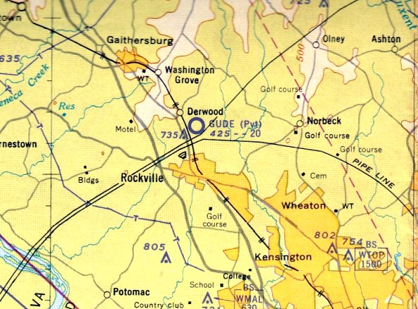
The last aeronautical chart depiction which has been located of Gude Airport was on the September 1972 Washington Sectional Chart (courtesy of Carl Buick).
It depicted Gude as a private airfield having a 2,000' unpaved runway.
Padraic Brown recalled that in the early & mid-1970s, a hangar was located on the north side of Gude Drive.
Gude Airport evidently closed at some point between 1972-74,
as it was no longer depicted on the March 1974 Washington Sectional Chart (courtesy of Jonathan Westerling).
Judy Perine Taylor recalled, “There was a lot of remorse when the County took the land for the airfield to use for the landfill.”
According to George Speake, "The reason it was closed was due to the fact that Montgomery County needed a new garbage dump.
They condemned the part of the nursery that included the airstrip & my grandfather was forced to begin renting a tiedown space at a close-by airport."
Padraic Brown noted “that the closing of Gude Airport wasn't the end of aeronautics in the area:
during the mid to late 1970s, model airplane flyers used to congregate on a strip of land south of Gude Drive,
directly across from the old hangar to fly their planes.”
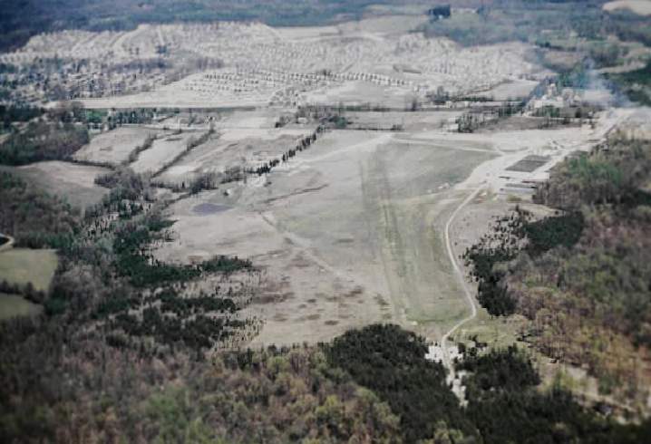
A 1979 aerial photo of the site of Gude Airport (courtesy of Jerry McCauley).
Jerry noted, “Eventually the landfill & other development expanded, taking the airstrip.
By 1979 the T-shaped metal hangar still existed,
but it had been cut off from the former strip by a private roadway approximately where Calhoun Drive is today.
The grass strip appears over-grown & shortened by landfill operations. Obviously, the airport was no longer in operation.”
By the time of the 1981 USGS topo map, the airfield was no longer depicted at all.
As seen in the 1988 USGS aerial photo, at some point between 1979-88 the former Gude hangar
had been replaced by building & parking lot, covering the west side of the former airport.
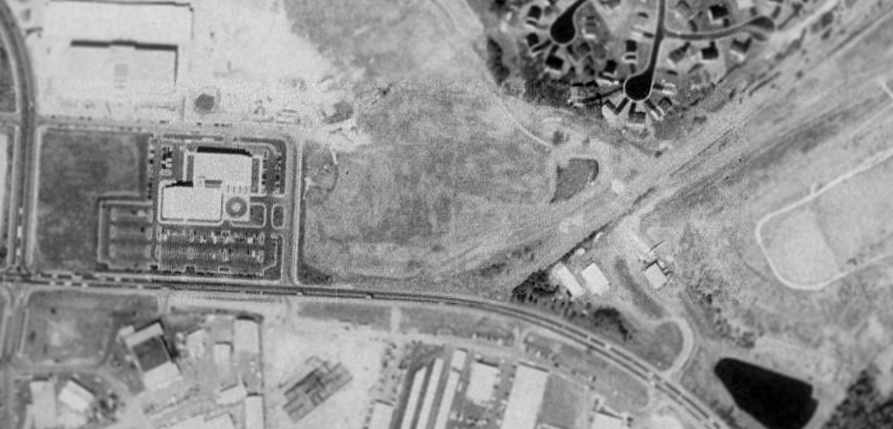
As seen in the 2002 USGS aerial photo, another building was constructed over the middle portion of the former Gude Airport at some point between 1988-2002,
leaving no trace of the former little airport.
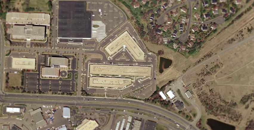
The site of Gude Airport is located northeast of the intersection of Calhoun Drive & Gude Drive, appropriately enough.
____________________________________________________
Turbo-Porter Field, Germantown, MD
39.19, -77.26 (Northwest of Washington, DC)
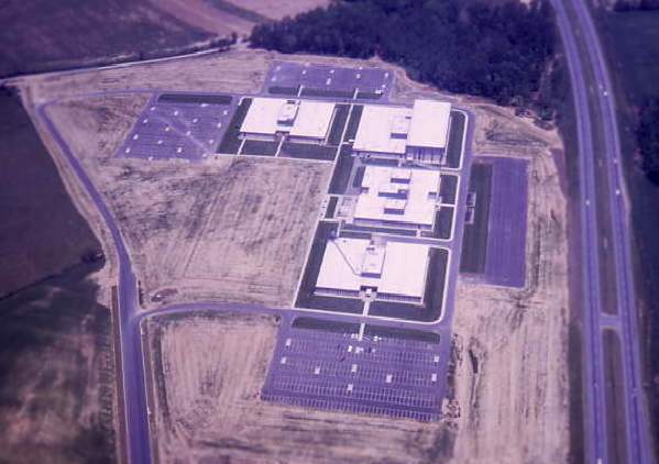
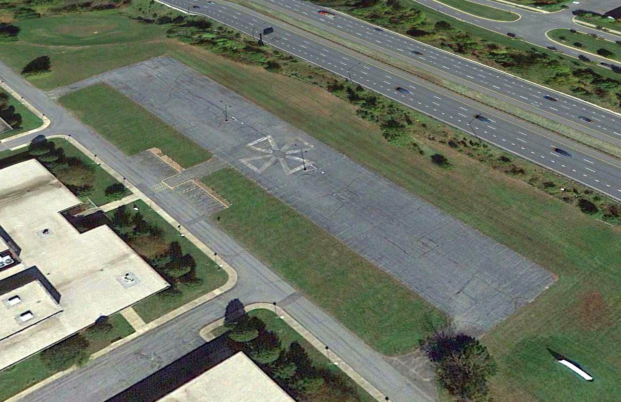
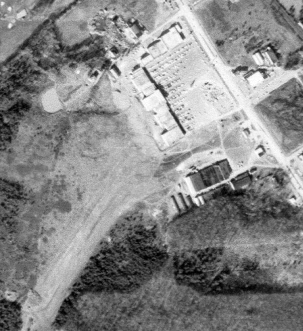
A 1967 aerial photo by Chris Kennedy of the Fairchild's Germantown facility (which was quite new at the time).
The STOL runway is the dark strip on the right, in between the buildings & Route 270.
This private Short Takeoff & Landing (STOL) runway was evidently built at some point between 1963-67,
as nothing but woods was depicted at the site on a 1963 aerial photo.
The earliest depiction of the airfield which has been located was a 1967 aerial photo by Chris Kennedy.
It depicted the STOL runway in between the new Fairchild facility & Route 270.
The short runway was built adjacent to the Germantown facility of the Fairchild Defense Company.
The runway consisted of a mere 600' asphalt strip, located between the Fairchild buildings & Route 270.
According to Chris Kennedy, Fairchild was license-building the Pilatus Turbo Porter in the 1960s,
and they used to land one at the Germantown STOL runway occasionally.
A total of 92 Porters were built by Fairchild, which had an aircraft factory nearby in Hagerstown, MD.
Turbo-Porter Field was not depicted on aeronautical charts from 1960, 1965, 1966, 1973, 1991, or 1998.
It may have been not depicted on the charts at the owner's request,
which is an option available to the owner of a private airfield.
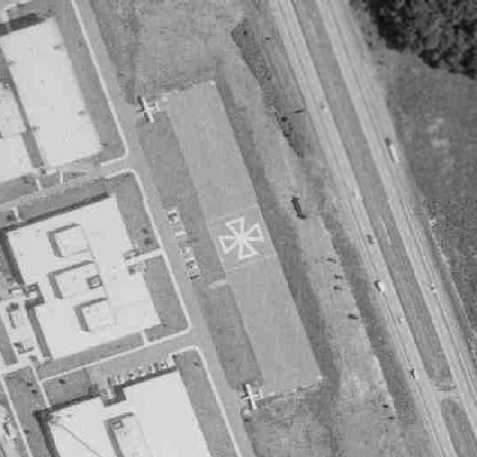
The only photo which has been located showing aircraft at the Turbo-Porter Field was a remarkable 1970 aerial view,
which depicted 2 Turbo-Porters parked on the field, one at at each taxiway leading from the runway.
Amazing to see fixed-wing aircraft could actually use a runway this short!
The runway had a large “iron cross” marking in the center – why?
The 1971 USGS topo map depicted the adjacent Fairchild office buildings, but did not depict the Turbo-Porter Field runway.
Turbo-Porter Field was not depicted on USGS topo maps from 1979, 1981 or 1984.
The only airfield directory reference to Turbo-Porter Field which has been located was in the 1982 AOPA Airport Directory (courtesy of Ed Drury).
It described Turbo-Porter Field as consisting of a 600' asphalt Runway 17/35,
and included the note: "Private. Closed to public. STOL Operation of company owned Porter only."
Merton Meade recalled, “I actually flew into the Turbo-Porter strip one time in a Porter, but as a passenger.
It was actually just lines painted on the car park!”
Jerry Duncan recalled, "At the time I was hired on in 1983, Fairchild Space & Electronics Company had just divided into 2 divisions:
Fairchild Space Company (of which I was an employee) & Fairchild Communications & Electronics Company.
It is my understanding that the Chairman of the Corporation, Ed Uhl,
used the runway when commuting between Germantown & his Eastern Shore home.
It was an awesome sight to watch that Porter wind up & jump into the air on such a short runway!"
Sean Maloney recalled, "I was a high school student at Seneca Valley High School from 1983-85
and the Pilatus Porter strip at the Fairchild facility was an active strip at that time.
We used to watch them land & takeoff with the STOL aircraft.”
John Jones recalled, “I was one of the Resident U.S. Government QA Inspectors at Fairchild
(covered both the CE & Space divisions) from 1989-93.
When I started there, the runway had been converted to a parking lot for some time.
We used to hear the stories about the planes coming in there all the time.
Fairchild Communications & Electronics split off from Fairchild Industries
and became Fairchild Space & Defense Corporation around 1991.
It was acquired by a French company, Matra, one of France's leading aerospace contractors.
They eventually sold the businesses to Orbital Sciences Corporation in 1994.
OSC [eventually] moved all its operations to its Dulles Annex.”
Sean Maloney recalled, "When I was visiting the area in 1992, the facility was no longer functioning as a runway."
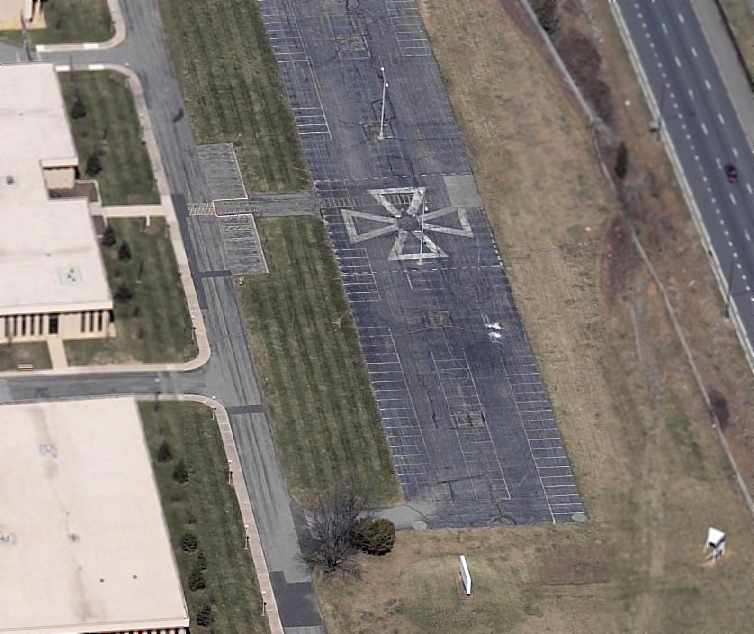
A circa 2005 aerial photo looking north at the south end of the former Turbo-Porter STOL runway showed that it still had the Iron Cross marking on the center.
Two parking lot light poles had been installed on either side of the cross symbol, making the runway unusable for aircraft.
A 2012 aerial view looking northeast showed the Turbo-Porter runway remained intact, with the Iron Cross symbol still in the center.
John Jones reported in 2013 of Turbo-Porter Field, “The old airfield still exists as a parking lot, where the facility is used by one of the for-profit tech schools.”
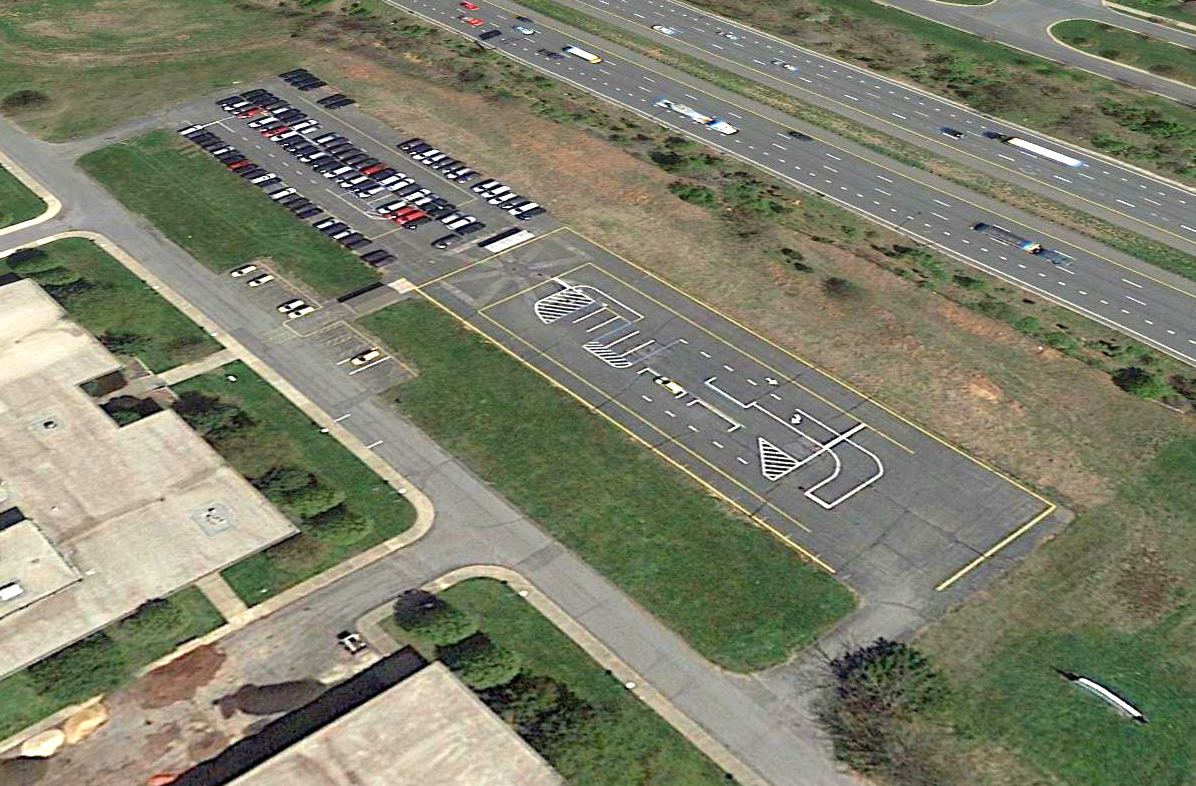
A 2016 aerial view looking northeast showed the Turbo-Porter runway remained intact, with the Iron Cross symbol still barely visible underneath more recent painted markings.
Padraic Brown reported, “As of approximately January 2018, the Turbo-Porter Field is no more!
That whole region has been under constant development the 10-15 years, and driving by the site a couple months ago, I noticed that the old Fairchild buildings [all except one] are now gone.
A couple weeks ago I drove by the site & everything is now dirt. All that's left are stubs of the northern & southern access roads (the 2 roads that went up to the taxiways).”
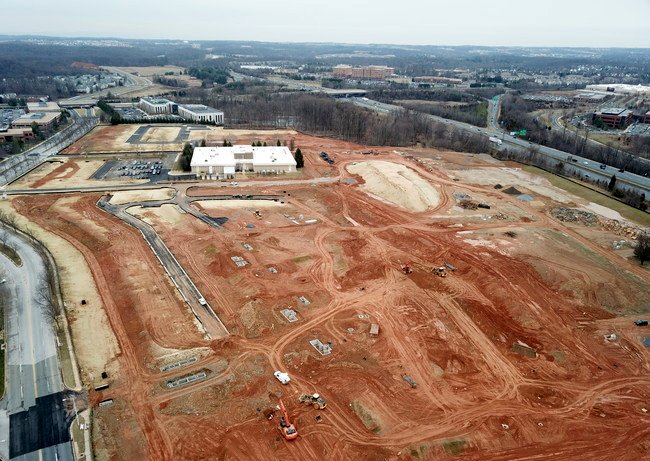
A 2018 aerial view looking north at the new "Elms at Century" development under construction on the site of Turbo Porter Field (courtesy of Padraic Brown).
Padraic Brown observed, “You can still see where the field was over on the right, and the stubs of the access roads towards Century Boulevard at the left.”
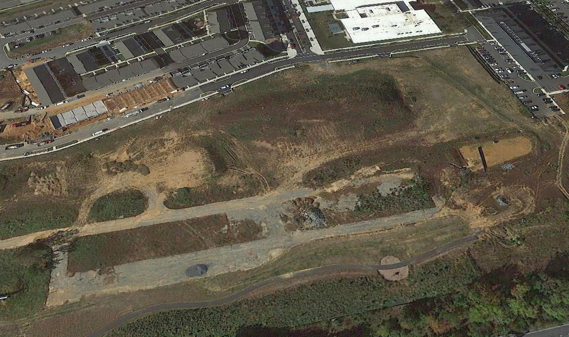
A 2020 aerial view looking west showed the remains of the Turbo Porter Field runway in the foreground, and the 1 remaining former Fairchild building at top-right.
Micheal Binder reported in 2021, “I was tooling around Germantown, and stopped to see what was left of Fairchild's Turbo-Porter Field.
I was seeing some remnants of the old runway, not terribly extensive due to abundant mud.”
Michael pointed out that a clue to this property's aviation heritage may be seen in the names of the streets which now cover it:
the streets are named Fairchild Drive, Stol Run, Peacemaker Drive, Provider Drive, and Flying Boxcar Drive.
____________________________________________________
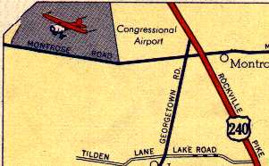
Congressional Airport, Rockville, MD
39.06, -77.13 (Northwest of Washington, DC)
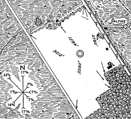
The airfield at Congressional Airport, as depicted on a 1929 Commerce Department Airway Bulletin (courtesy of Michael McMurtrey).
Congressional Airport was Montgomery County's first commercial airfield.
According to the book "Maryland Aloft" by Preston, Lanman, and Breilhan,
"In 1928, the Congressional School of Aeronautics leased 275 acres from the Wagner family
with the aim of establishing a training facility & airport.
This arrangement changed in the following year, when Congressional Airport, Inc.
purchased 269 acres of land from the Wagner family.
According to some accounts, the airport's founder was Major Harry Horton, a noted aviator.
Horton's reputation helped to ensure the success of the facility,
which became the scene of popular aerial demonstrations."
A 1929 Commerce Department Airway Bulletin (courtesy of Michael McMurtrey)
depicted the airfield area at Congressional Airport as consisting of a rectangular grass field, roughly 3,000' x 2,000',
on which were laid out four runways, the longest measuring 3,212'.
A single hangar was situated on the eastern edge of the field,
along Route 240 (later to become Rockville Pike).
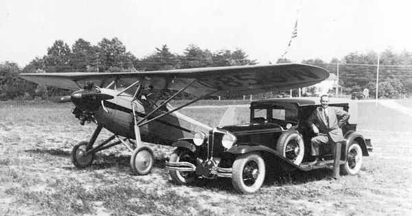
A May 1930 photo (courtesy of Don Warrington) of Chet Warrington at Congressional Airport with his two loves & livelihoods: the airplane & the car.
The plane is a Davis D-1; Chet was a Davis dealer, and he took his pilot's license test in a Davis. His Davis sales lot was at Congressional.
During its development stage, Congressional was touted
as one of the most modern & technically equipped airports in the United States,
complete with a flying school, sight-seeing flights & inter-city passenger service.
Advertising materials stressed the airfield's ready accessibility by street rail to both Georgetown & Rockville,
and easy connections to the B&O Railway Metropolitan Branch.
In addition, instant legitimacy was lent to the budding endeavor by Major Harry Horton,
the airport's founder & an aviation legend.
In its early days, Congressional was the site of all kinds of flying demonstrations.
Entire families, dressed in their Sunday finery, arrived with picnic baskets to spend their
weekend afternoons watching the pilots perform heart-stopping acts of aerial acrobatics.
The May 1932 Washington Sectional Chart depicted Congressional Airport as a commercial/municipal airport
which had Commerce Department Airway Beacon #2.
Robert Parks recalled, “I grew up in the area in the early 1930s.
As a kid I frequented every airport that I could get to to watch, wash, and hopefully get a ride in something.
My first airplane ride was at Rockville [Congressional] Airport on 6/19/35, my 9th birthday.
We lived in Bethesda at the time and my ride was in an Aeronca C-3.”
Paul Shank recalled, “My flight instructor, Lt. Colonel C. H. Armstrong also was given his first airplane ride at that airport in the same time period in a C-3, possibly the same one.”
and a hangar marked “Congressional Airport” on its roof.
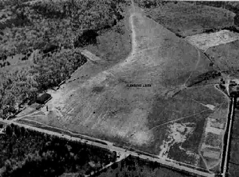
An 8/21/34 aerial view looking northeast depicted Congressional Airport as having an open grass landing area, with a hangar along the southeast side.
The Airport Directory Company's 1937 Airports Directory (courtesy of Bob Rambo)
described Congressional Airport as having a rectangular 2,500' x 2,000' grass landing area.
The aerial photo in the directory depicted a single hangar at the eastern corner of the field.
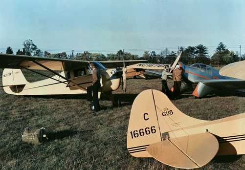
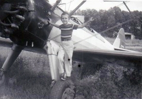
A circa 1930s photo of pilots inspecting their planes at Congressional Airport, including an Aeronca K & a low-wing Aeronca LA, LB, or LC.
An undated photo from a circa 1930s article showing a single-engine high-wing monoplane in front of Congressional Airport's hangar.
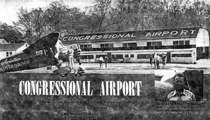
A late 1930s photo of pilot Ken Finn & airport owner Arthur Hyde at Congressional Airport (courtesy of Linda Finn).
Linda Finn recalled her father Ken Finn “was in a flying club there at Congressional Airport along with my mother,
and then later he went with the Civilian Pilot Training Program in various capacities.”
According to a 2/78 article by Jack Perine in the Mid Atlantic Soaring Association's Convector,
“The most prominent pre-war [WW2] club was the Washington Glider Club which operated a 'Franklyn Utility' from Congressional Airport.
One of its members was entertainer Arthur Godfrey.”
According to Art Hyde Jr (son of Congressional Airport owner Arthur Hyde), “I understand Arthur Godfrey flew at Congressional & may have learned how to fly there.”
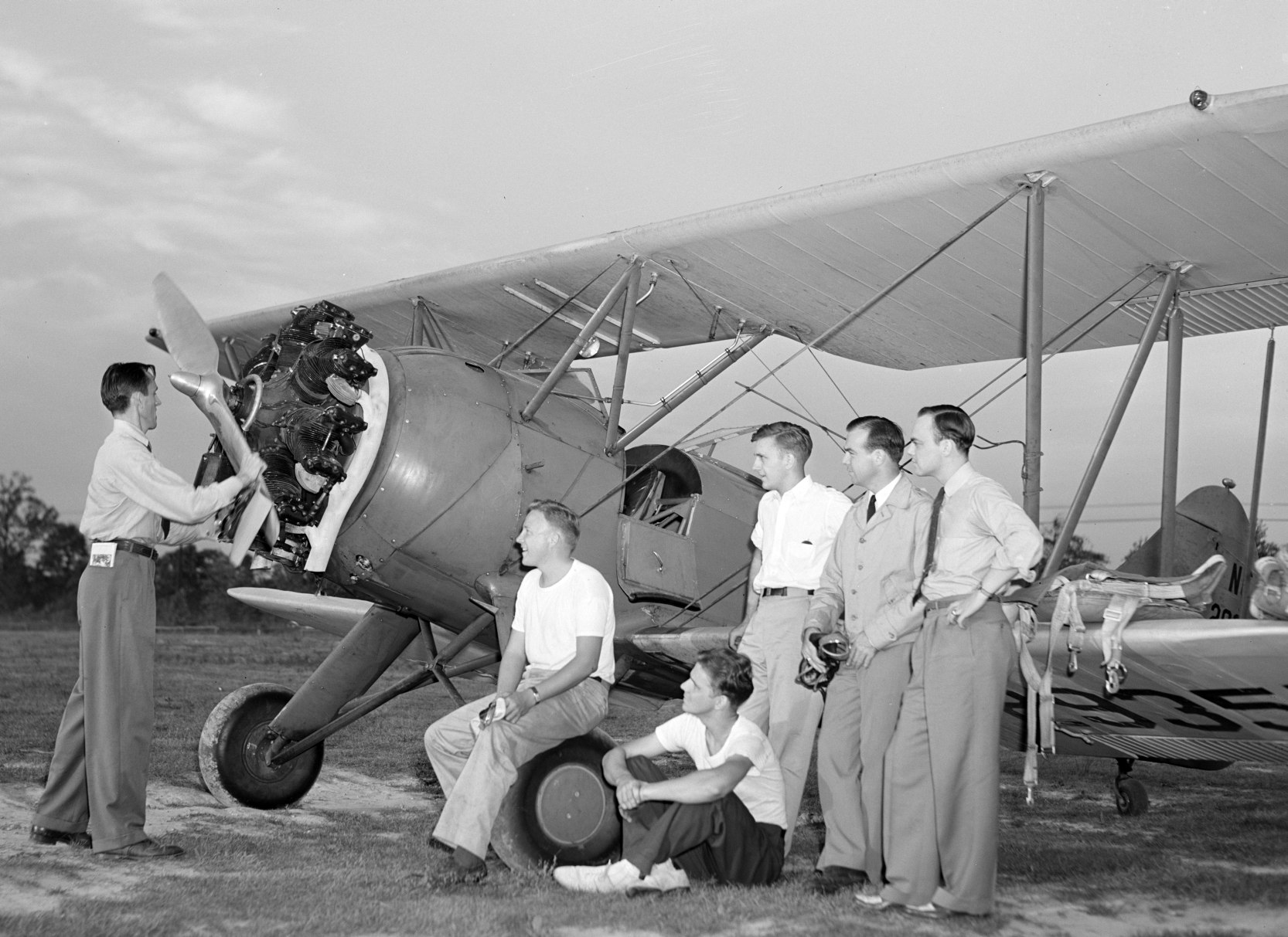
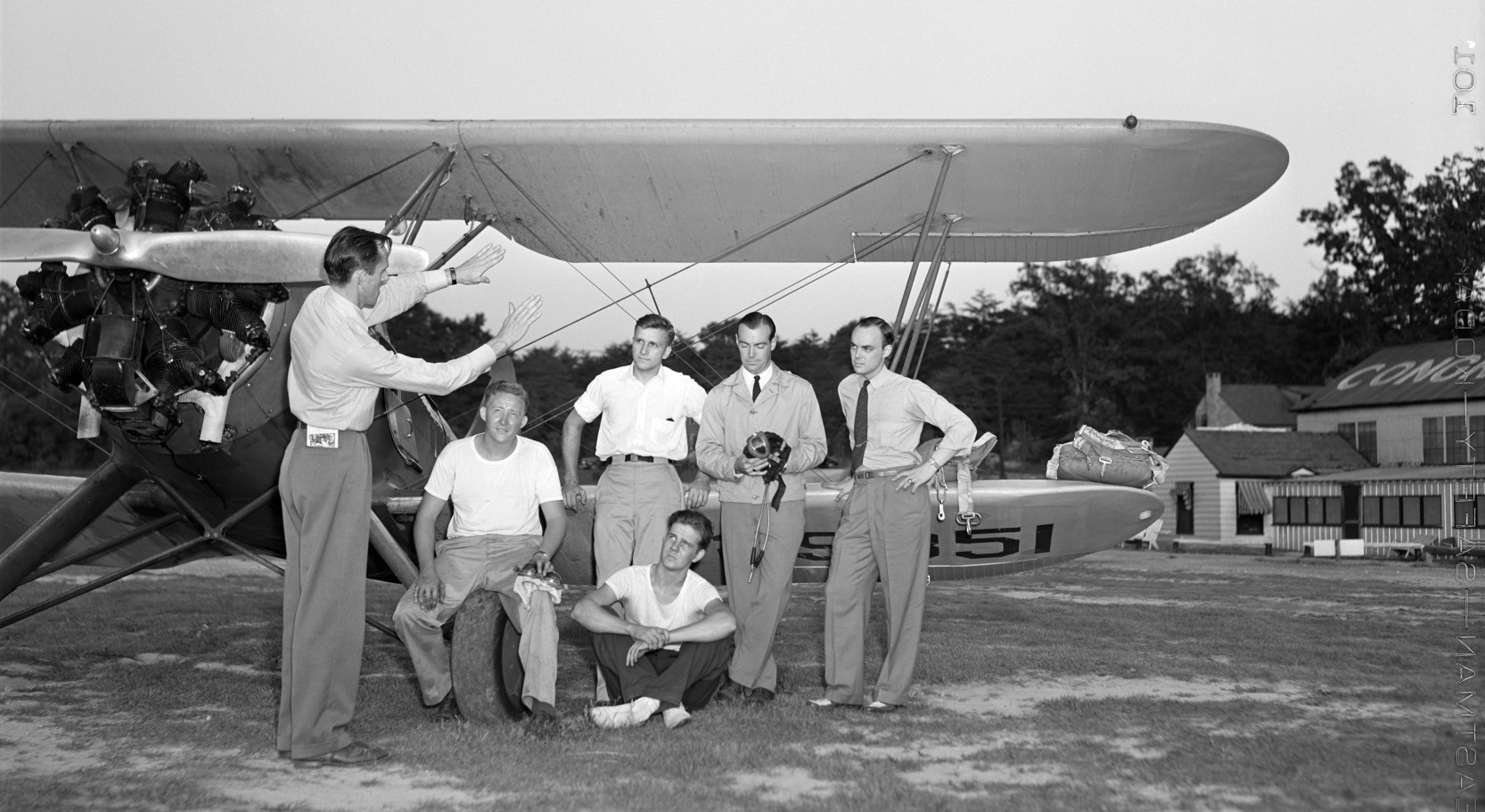
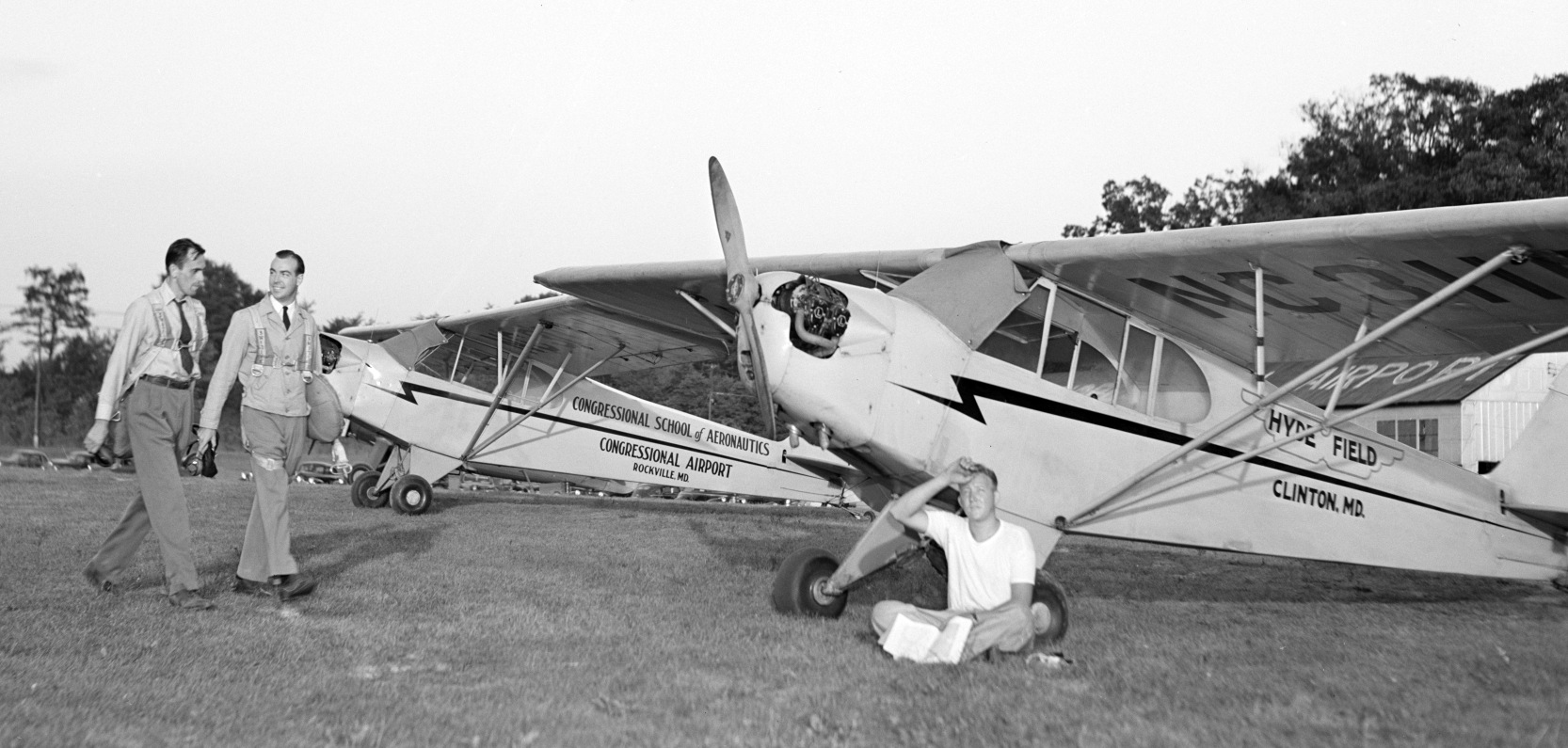
Note one cub was marked “Congressional School of Aeronautics Congressional Airport”, and the other “Hyde Field Clinton MD”.
Congressional Airport operated continuously for 30 years, with the exception of a brief wartime closure during 1942.
A circa 1942-43 aerial view looking southwest at Congressional Airport from the 1945 AAF Airfield Directory (courtesy of Scott Murdock)
depicted the field as having an open grass landing area, with a hangar along the east side.
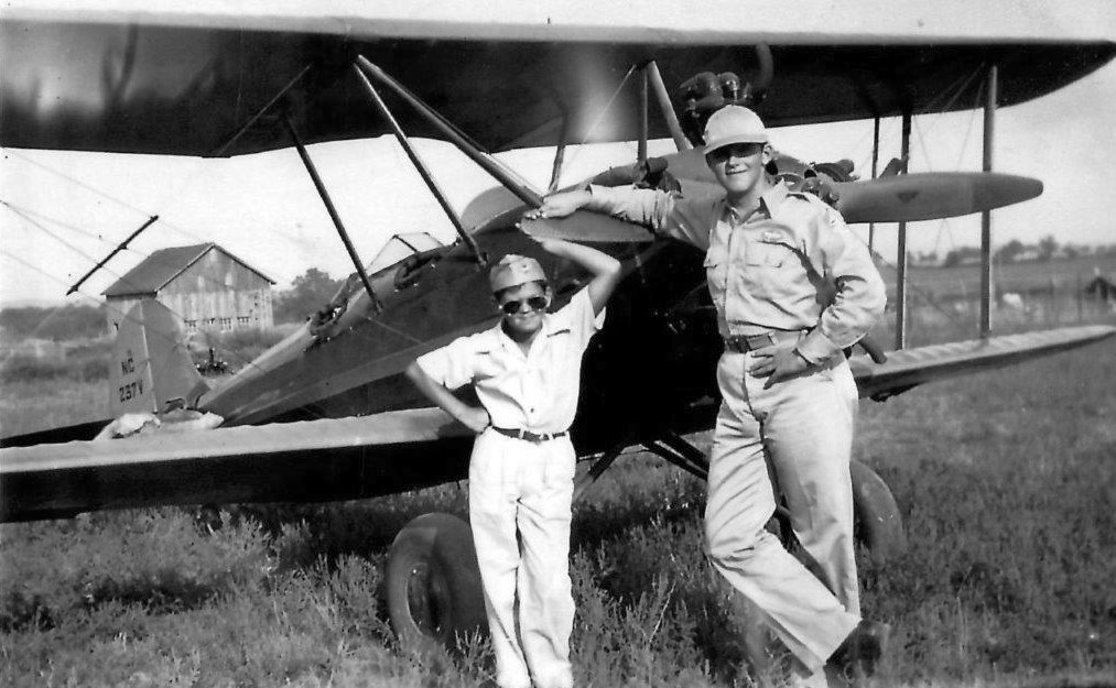
A Summer 1943 photo of Rich & Bob Milburn in front of a Fleet trainer biplane at Congressional Airport.
Congressional Airport was depicted on the May 1944 Washington Sectional Chart (courtesy of Ron Plante)
as a commercial/municipal airport.
Congressional was described by the 1944 US Army/Navy Directory of Airfields (courtesy of Ken Mercer) as having a 3,100' unpaved runway.
It included the remark, "Restricted to CAP [Civil Air Patrol] operations."
The 1945 AAF Airfield Directory (courtesy of Scott Murdock) described Congressional Airport
as a 150 acre irregularly-shaped property within which were 2 sod runways, measuring 3,072' northeast/southwest & 1,770' east/west.
The field was said to have 4 hangars, the largest being a 125' x 70' brick & metal structure.
The field was described as being privately owned & operated.
Mike Fitzpatrick reported, “My father (Donald Fitzpatrick) was a fighter pilot in the U.S. Marine Corps Reserves at the time
and he must have rented a plane at Congressional in order to take my mother (Marcella Fitzpatrick) up for a ride.”
According to the book "Maryland Aloft", "By 1947, its assets included 10 hangars & an office building with a lounge.
The landing area, however, was still an unpaved field."
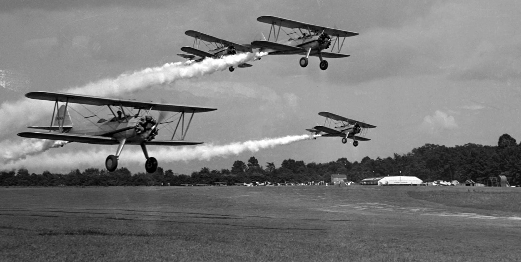
A circa 1940s photo of 4 biplanes (Stearmans?) making a demonstration of anti-malaria DDT spraying at Congressional Airport, with the hangar & other planes visible in the background.
According to the Congressional Flying Club, “It was a group of Civil Air Patrol members, including Eberhard Trams, who founded the Congressional Flying Club in the late 1940s.”
A depiction of part of the property of Congressional Airport,
from a 1949 Shell road map (courtesy of Mike Keefe).
A circa late 1940s – early 1950s aerial view looking north at Congressional Airport.
Photo is courtesy of Julian F. Cottrell, who obtained his Private Pilot's License at Congressional in 1947.
A circa late 1940s – early 1950s aerial view looking east at Congressional Airport (courtesy of Julian F. Cottrell).
A circa late 1940s – early 1950s photo of Civil Air Patrol aircraft at Congressional Airport (courtesy of Julian F. Cottrell).
A Stearman for sale at Congressional Airport in 1948, for what was at the time a staggering sum of $500 (courtesy of Julian F. Cottrell).
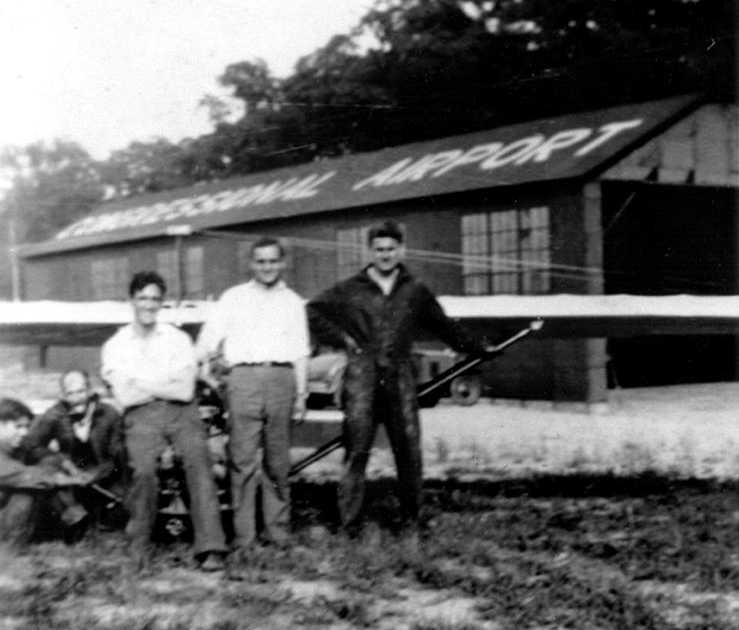
A 1948 advertisement for Congressional Airport (courtesy of Kevin Walsh).
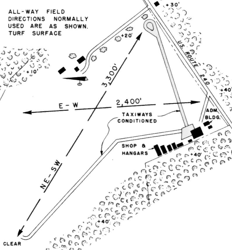
Congressional Airport, as depicted in the 1950 MD Airport Directory (courtesy of Stephen Mahaley).
The directory depicted Congressional Airport as having an "all-way" turf landing area,
within which were two "normally used" runway areas,
measuring 3,300' (northeast/southwest) & 2,400' (east/west).
A total of nine airport buildings (including a shop, hangars, and administration building)
sat along the east side of the field.
Two "conditioned" taxiways led from the hangars to the northeast & southwest ends of the landing area.
A 1950 photo at Congressional Airport (courtesy of Mike Ross).
According to Mike Ross, the photo is “of my Father, Peter Ross (right) with his friend, Johnny Curtain (center) and flight instructor, unknown name (left).
My father said this was taken just before he left to go to the Army during the Korean War. He said the plane was a J2 Cub.
He lived in Glen Echo MD & he would drive up there to train when he could.
He said he liked the airfield because it was close enough to DC to travel to & was saddened when it closed.”

The 1951 Washington Local Aeronautical Chart (courtesy of Tim Zukas)
depicted Congressional Airport as having a 3,300' unpaved runway.
An early Fall 1951 aerial photo of Congressional Airport (courtesy of Chris Kennedy)
showed several planes parked on the southeast side of the field.
Elizabeth Haynes recalled, “It had never been the practice in my family to give money for a gift within the family.
We had Christmas & birthday presents, but always well-chosen items, never cash.
For my 16th birthday, my mother gave me a birthday card with a $10 bill in it,
and the message, 'Maybe there’s something you would like for your birthday that I can’t buy for you.'
The following Saturday, a calm, cloudless day in June, I told her I was going out to spend my $10, and would be back for dinner.
I took my baby-sitting earnings & rode city buses from Alexandria to Congressional Airport & had a flying lesson - a Cub J-3 -
$6 to rent the plane, $3 for the instructor, and $1 for a logbook, which I still have.
As a Civil Air Patrol cadet, I had flown from that airport with CAP pilots, and it was the only one I knew how to get to on public transportation.”
Congressional Airport was described in the Aerodromes table on the 1951 Washington Sectional Chart (courtesy of Mike Keefe)
as having an "all-way" 3,300' unpaved landing area.
A 12/5/55 photo of an Aeronca conducting one of Greg Weiser's first flights at Congressional Airport.
The last aeronautical chart depiction which has been located of Congressional Airport was on the July 1956 Washington Local Aeronautical Chart.
It depicted Congressional Airport as having a 3,300' unpaved runway.
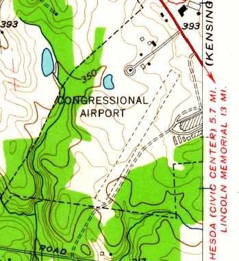
The 1956 USGS topo map depicted Congressional Airport as having a single unpaved northeast/southwest runway,
with a few small buildings on the north side.
By the late 1950s, however, nearby residential construction was making landings & takeoffs problematic.
The increasing retail value of the land & high taxes made the continued operation
of the bustling airfield less attractive than commercial development,
and Congressional Airport's owner, Arthur Hyde (who also owned Hyde Field in Prince George's County)
began to redevelop the property to begin construction on Congressional Shopping Center.
According to the Congressional Flying Club, “When Congressional Airport was closed to make way for the shopping center in 1956 [contradicted by the 1957 photo below],
the Congressional Flying Club & Civil Air Patrol squadron moved out to Davis Airport.”
A 5/4/57 photo of Greg Weiser on an Steaman at Congressional Airport.
A 1957 aerial view depicted Congressional Airport just before it closed.
There were still a total of over 23 light aircraft present on the field,
yet the 1st building of the new shopping center had already been constructed over the north side of the property,
almost directly in line with the northeastern end of the runway.
Congressional Airport was evidently closed at some point during 1957,
as it was no longer depicted on the 1957 Washington Sectional Chart (courtesy of Mike Keefe).
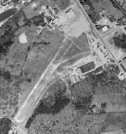
A 12/14/59 USGS aerial view showed the shopping center covering the north side of the Congressional Airport property,
although the hangars remained on the southeast side, and the southwestern portion of the runway remained intact.
By the time of a 1963 aerial photo, the shopping center had covered the majority of the site of Congressional Airport.
However, even after majority of Congressional Airport was gone,
one of the former hangars on the south side of the site continued to stand & was reused as a roller-skating rink.
A 1970 aerial photo, still showed the hangar remained intact.
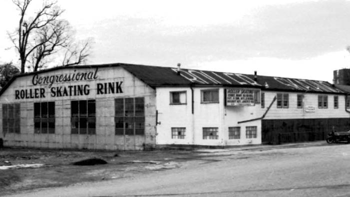
An undated view of a former hangar at Congressional Airport, reused as the Congressional Roller Skating Rink.
Marc Cantor recalled, "I used to go the roller skating rink as a little kid [circa 1974-76]."
According to the book "Maryland Aloft", the former hangar remained in use as a roller-skating rink until 1983.
It was demolished in 1984.
Curiously, a historical survey of the Congressional Plaza shopping center in 1986
found a single architectural element which still remained at that point from the former airport:
a barrel-roofed structure, located at the rear of a furniture store whose front faced Congressional Lane,
which was being reused as office space.
The original function of this structure was not determined.
A site visit in 2002 showed that this structure, the last trace of the former airport, had been removed.
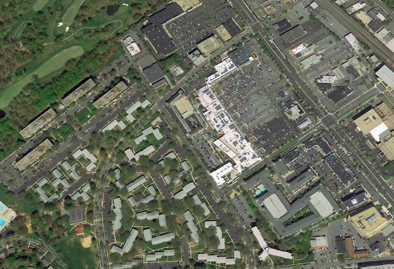
A 2018 aerial view looking north showed not a trace remains of Congressional Airport.
Thanks to Charles Bruno for information about Congressional.
See also: http://www.quirksworld.com/mm-mayjun97.html
____________________________________________________
Since this site was first put on the web in 1999, its popularity has grown tremendously.
If the total quantity of material on this site is to continue to grow,
it will require ever-increasing funding to pay its expenses.
Therefore, I request financial contributions from site visitors,
to help defray the increasing costs of the site
and ensure that it continues to be available & to grow.
What would you pay for a good aviation magazine, or a good aviation book?
Please consider a donation of an equivalent amount, at the least.
This site is not supported by commercial advertising –
it is purely supported by donations.
If you enjoy the site, and would like to make a financial contribution,
you
may use a credit card via
![]() :
:
Please consider checking the box to make a monthly donatation.
For a mailing address to send a check, please contact me at: paulandterryfreeman@gmail.com
If you enjoy this web site, please support it with a financial contribution.
please contact me at: paulandterryfreeman@gmail.com
If you enjoy this web site, please support it with a financial contribution.
____________________________________________________
This site covers airfields in all 50 states.
For the site's main menu: Home