Abandoned & Little-Known Airfields:
Northeastern Massachusetts
© 2002, © 2022 by Paul Freeman. Revised 9/18/22.
This site covers airfields in all 50 states: Click here for the site's main menu.
____________________________________________________
Please consider a financial contribution to support the continued growth & operation of this site.
Digital Equipment Corporation Heliport (added 2/3/22) - Haverhill Dutton Airport (revised 6/10/22) - Haverhill Riverside Airport (revised 1/7/22) - Lowell Airport (revised 1/7/22)
Manter Field (added 9/18/22) - Pleasant View Airport (added 7/2/20) - Ten Pound Island Coast Guard Air Station (revised 1/7/22)
____________________________________________________
42.748, -70.926 (Northeast of Boston, MA)
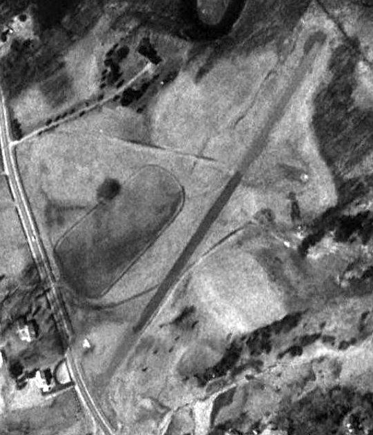
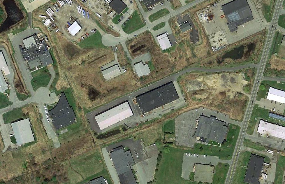
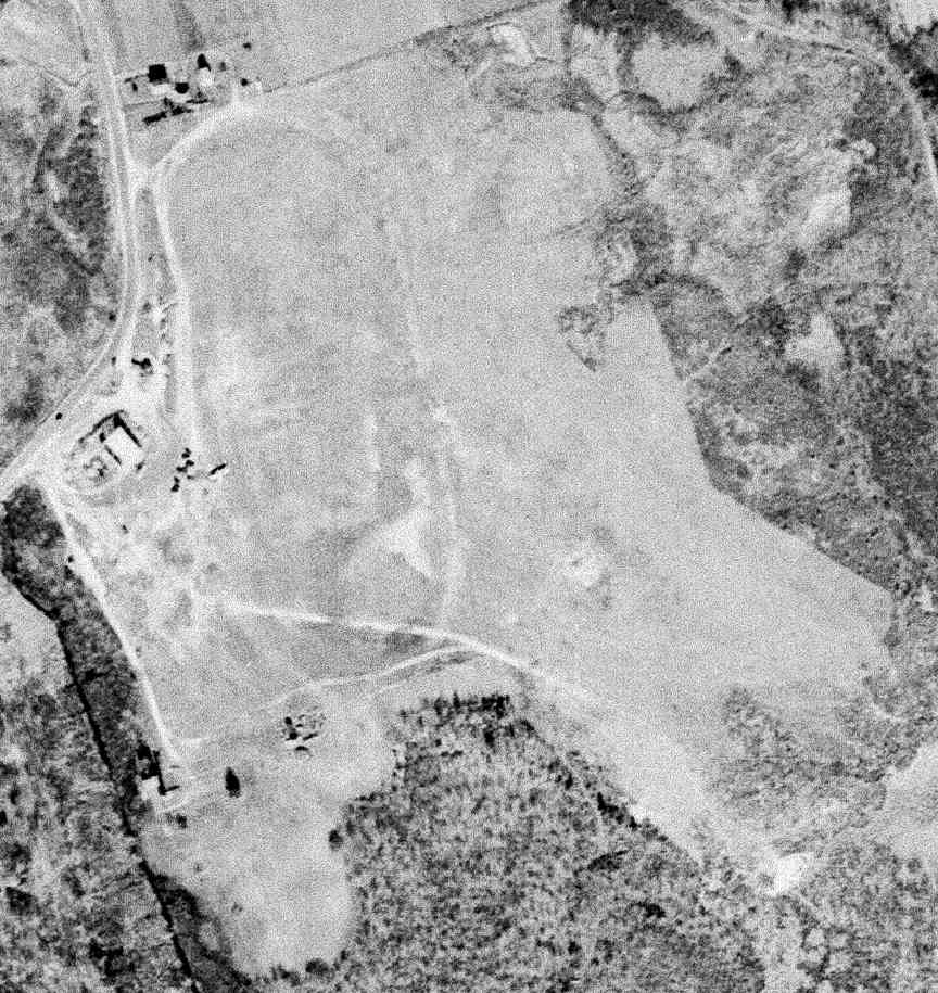
Manter Field, as depicted on a 1995 aerial view.
Not much is known about this small presumed private airfield, including its name.
Manter Field was evidently constructed at some point between 1978-86,
as it was not yet depicted on a 1978 aerial photo or the 1981 Boston Terminal Chart.
No airfield was depicted at this location on the 1986 USGS topo map, or later topo maps.
The earliest depiction which has been located of Manter Field was a 1986 aerial photo.
It depicted a single paved northeast/southwest runway, with 1 light single-engine plane parked next to the southwest side.
Manter Field was not depicted on the 1992 Boston Terminal Chart.
The earliest photo which is available of Manter Field was a 1995 aerial view.
It depicted a single paved northeast/southwest runway, with 1 light single-engine plane parked next to the southwest side.
Manter Field was still intact in a 2001 aerial view, but the plane was gone.
Manter Field was evidently removed at some point between 2001-2003,
as a 2003 aerial photo showed athletic fields having covered the southwestern portion of the runway.
Paul Zahornasky reported in 2018, “Manter Field is currently a recreational area for soccer & lacrosse
but apparently was a private airfield at some point, according to some of the soccer parents that I was talking to during a game.”
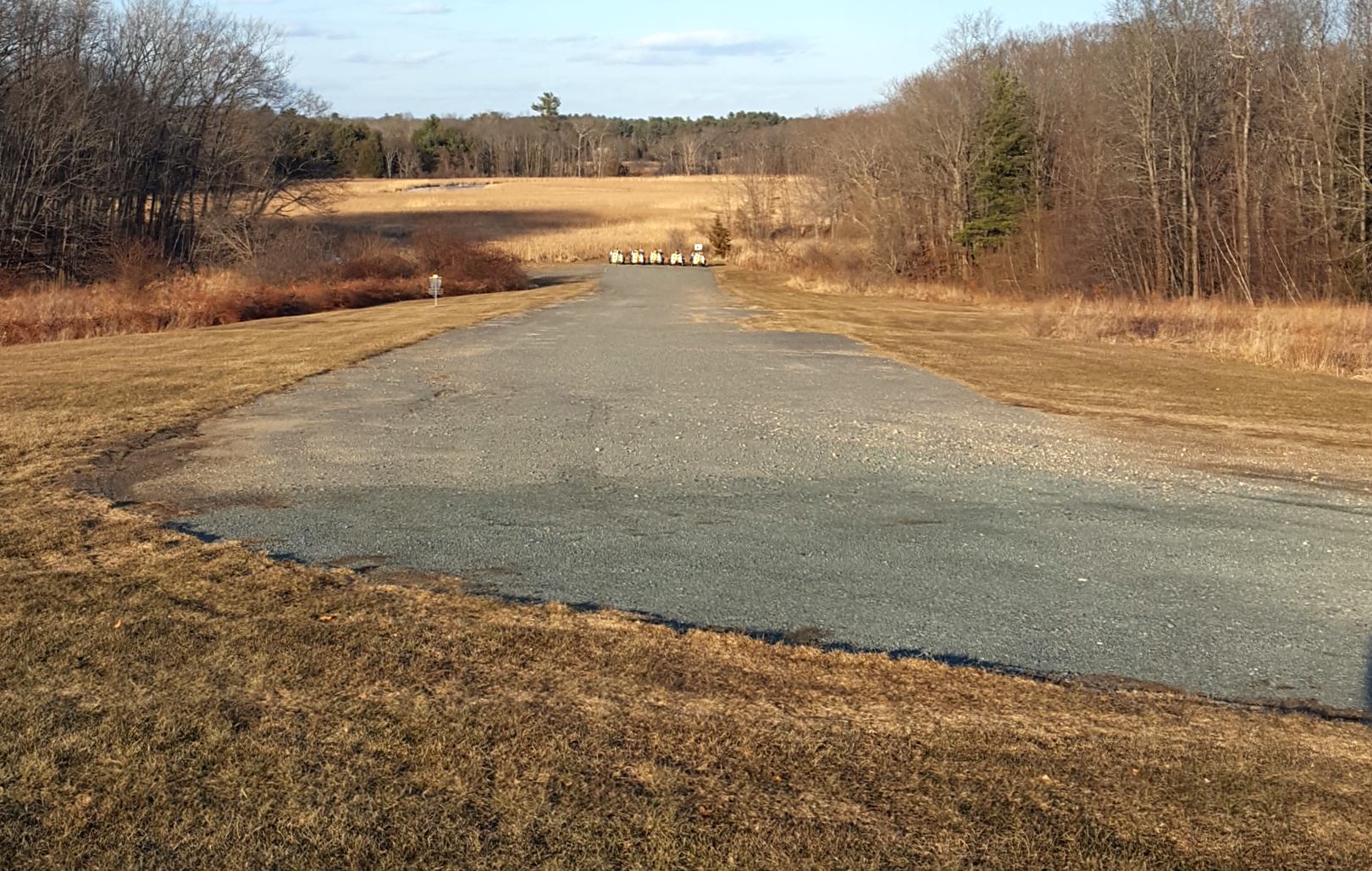
A 1/26/19 photo by Paul Zahornasky looking northwest along the remains of the Manter Field paved runway.
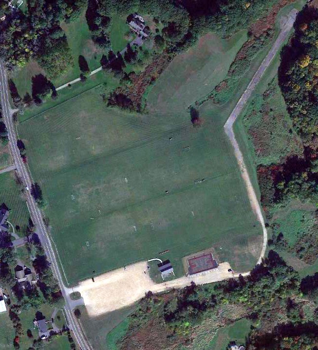
A 2022 aerial view shows the northeastern portion of the Manter Field paved runway remains, but the rest of the site is covered by athletic fields.
As of 2022, street maps label this property as Manter Fields.
Thanks to Paul Zahornasky & Sean O'Brien for pointing out this airfield.
____________________________________________________
Digital Equipment Corporation Heliport (MA91), Maynard, MA
42.417, -71.45 (West of Boston, MA)
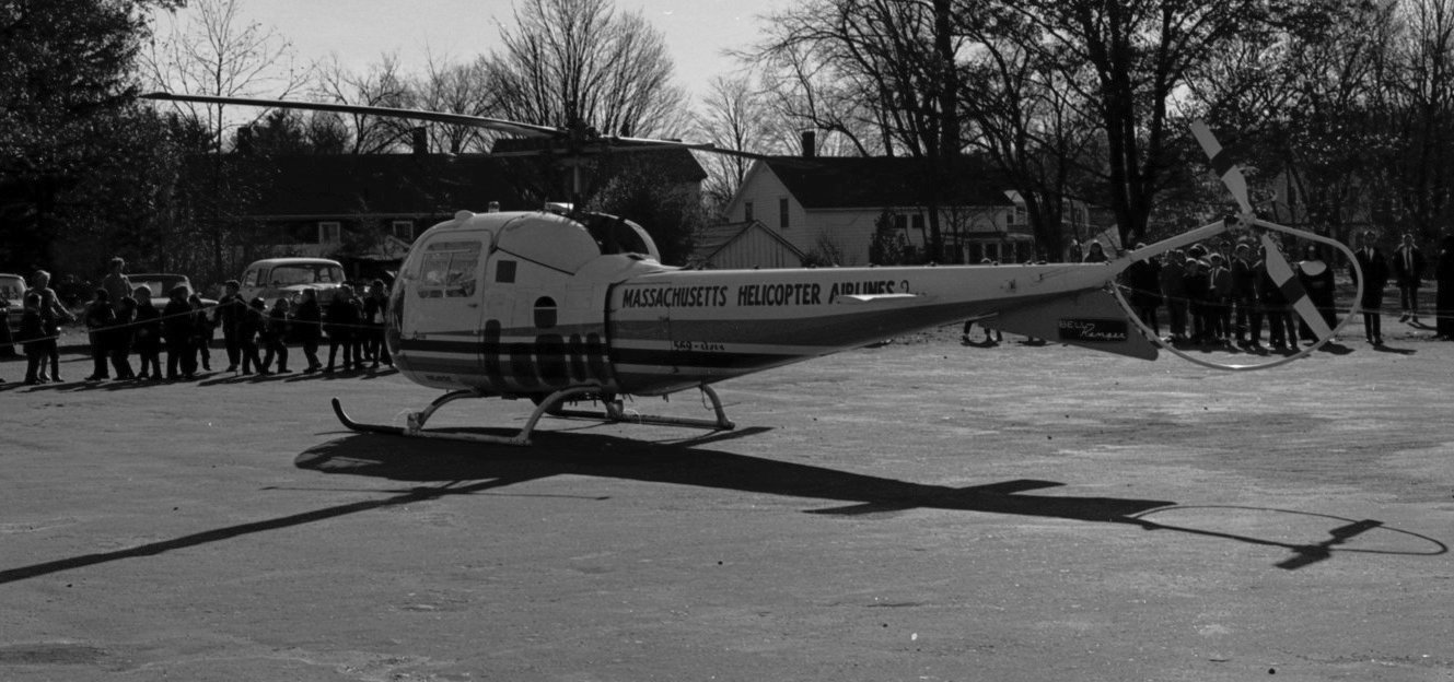
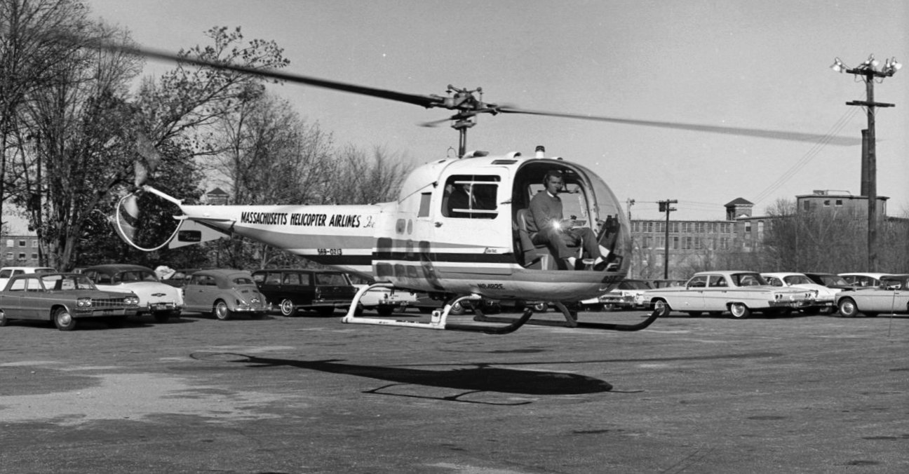
A 1965 photo of a Massachusetts Helicopter Airlines Bell 47J2 Ranger on the new DEC Helistop with children & employees awaiting a takeoff
(courtesy of the Computer History Museum, used with permission, via Jonathan Westerling).
The Digital Equipment Corporation moved into facilities in Maynard in 1957.
According to Jonathan Westerling, around 1965, “Massachusetts Helicopter Airlines had initiated a service ferrying people to & from Boston's airport
and the various industrial parks which has sprung up around the city's Route 128 beltway.
An area of what is now the Sudbury Street Parking upper lot was roped off as the helistop so the airline could demonstrate a landing & departure.
About 100 DEC employees & local children attended the landing.
A 1965 photo of a Massachusetts Helicopter Airlines Bell 47J2 Ranger taking off from the new DEC Helistop, with DEC's Mill Pond headquarters in the background
(courtesy of the Computer History Museum, used with permission, via Jonathan Westerling).
Jonathan Westerling reported, “As the 1960s progressed, Digital's success found it expanding rapidly, but unable to find office space near its Maynard headquarters.
They began purchasing additional campuses all around Boston & initiated their own dedicated helicopter service to ferry people between locations.
According to Frank Ignachuck (via decconnection.org), Vietnam veteran Paul McGovern, was hired as Digital's first helicopter pilot.
The division of the company was operated as 'Digital Aviation',
eventually with its own hangar & headquarters at Building 1730 on Hanscom Field about 10 miles northeast of the Maynard headquarters & helistop.”
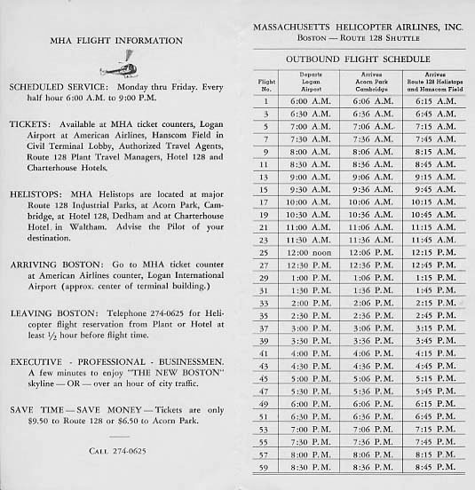
A 1960s Massachusetts Helicopter Airlines timetable (courtesy of Tom Heitzman via timetableimages.com).
The DEC Heliport was not depicted on USGS topo maps from the 1960s/70s/80s,
nor on Sectional Aeronautical Charts from the 1960s/70s/80s/90s.
The first directory listing which has been located of the DEC Heliport was in the 1974 AIA Heliport Directory (courtesy of Jonathan Westerling).
Jonathan Westerling reported, “By this time Digital was operating 3 Bell 206B aircraft.”
The 1977 AIA Heliport Directory (courtesy of Jonathan Westerling) described the DEC Heliport as measuring 60' x 20'.
Jack Falvey reported, “The helicopters were not executive perks at DEC; they were used by any & all employees who wanted to avoid traffic in going from place to place.
This egalitarian policy further emphasized just how different DEC was & how indifferent they appeared to be to the cost of anything.
In doing [my] case study, we were told that DEC had state-of-the-art video-conferencing facilities that no one used because it was sexier to take the helicopters.”
According to an article by Robert Mitchell in ComputerWorld Magazine, "Anyone could take a helicopter to any facility.
But there was a catch: It was first-come, first served & a round trip was not guaranteed.
If the weather soured or you missed the last helicopter back you might be stuck 35 miles away in Maynard. Fortunately, they also had shuttle vans."
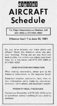
The cover of a 4/1/81 DEC Aircraft Schedule (courtesy of Craig Morris of aviationworldcollectibles.com, used with permission).
It listed over 25 flights a day landing at the DEC Maynard heliport to & from locations around Boston & New Hampshire.
The 1982 AIA Heliport Directory (courtesy of Jonathan Westerling) described the DEC Heliport as operating 4 Bell 206Bs & 11 (!) Bell 206BIII helicopters.
Abram Dancy recalled, “In the 1980s I recall going to the Digital plant in Merrimack to watch the helicopters come & go.
There was a hot-dog stand there for the spectators to get lunch. My recollection is that they landed adjacent to one of the ponds behind the buildings.”
The 1984 AIA Heliport Directory (courtesy of Jonathan Westerling) described the DEC Heliport as having a 60' x 20' concrete helipad.
According to a 6/9/84 New York Times article, "The Digital Equipment Corporation, based in Maynard, uses a fleet of 6 helicopters
to shuttle employees & customers among 13 office buildings & plants it occupies in the Boston suburbs & eastern Massachusetts."
According to a 1988 FAA report, "One prime example of helicopter use by high technology firms
is the in-house air transportation system developed & fully utilized by Digital Equipment Corporation.
The Digital system includes 7 helicopters that are used to transport employees between Digital's various office & plant locations in New England,
and directly to Logan International Airport, where the Digital helicopters have been assigned a gate at the terminal building."
According to Steve Wagner, "One of the uses of DEC's helicopters most familiar to Maynard residents was to bring Santa Claus to town for the annual Christmas parade."
Jonathan Westerling reported, “The success of Digital Equipment Company began to sour in the 1990s & by 1998 the company was purchased by Compaq.
At some point helicopter operations were suspended as campus after campus was closed.
It is a testament to the pilots & mechanics who worked at Digital & ran its private helicopter airline for over a decade
with hundreds of flights a day at its peak, and never experienced a major incident.”
A 2010 aerial photo showed the former DEC Maynard buildings were still intact.
A 2011 "Ken Olsen Tribute Day" historical display included a helicopter tail rotor blade made into a clock signed by Digital Aviation employees which had been given to the company founder.
A 2013 aerial photo showed the former DEC Maynard buildings had been razed.
A 2019 aerial photo showed new residential construction had started on the Maynard site, erasing any trace of the DEC Heliport.
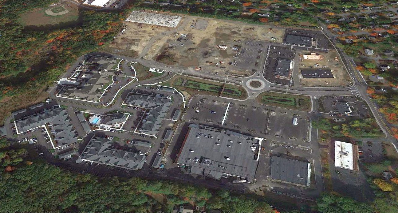
A 2020 aerial view looking north showed no trace remaining of the DEC Heliport, with the site being covered by new residential construction.
The only hint of the site's history is the name of the complex's main road, Digital Way.
Jonathan Westerling reported, “As of 2021 at least 10 of Digital's previous helipads throughout New England continue to be registered with the FAA,
though most have had their name changed to 'Compaq'.”
____________________________________________________
Pleasant View Airport, Newburyport, MA
42.803, -70.887 (North of Boston, MA)
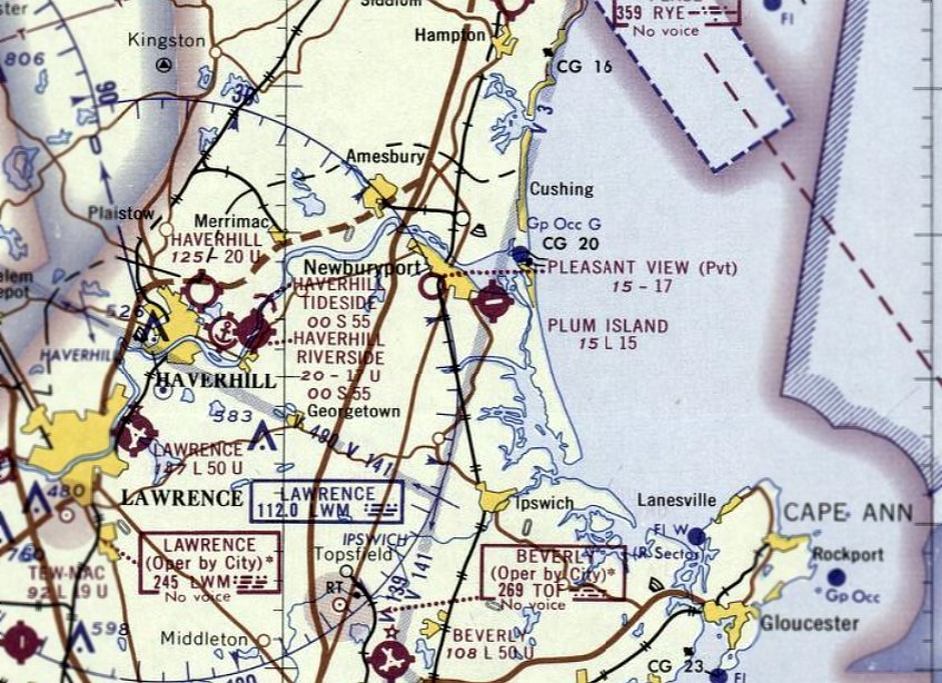
Pleasant View Airport, as depicted on the September 1965 Boston Sectional Chart.
Photo of the airport while open is not available.
This small private airfield was not yet depicted on a 1938 aerial photo or on the May 1960 Boston Sectional Chart.
According to Undercurrents, Ed Reardon & his brother started Pleasant View Airport as they had a number of planes & nearby Plum Island Airport did not have space.
The Reardon brothers rented the site from the Archdiocese of West Newbury for $250/year.
The earliest depiction which has been located of Pleasant View Airport was on the September 1965 Boston Sectional Chart.
It depicted Pleasant View as a private airfield having a 1,700' unpaved runway.
The earliest photo which has been located of Pleasant View Airport was a 1965 aerial view.
It depicted a short unpaved northeast/southwest runway, with 1 small building on the southeast side.
There were no aircraft visible on the field.
The only photo which has been located showing aircraft at Pleasant View Airport was a 1966 aerial view, which showed 3 single-engine aircraft parked on the southeast side.
A few more small buildings had been added to the southeast side.
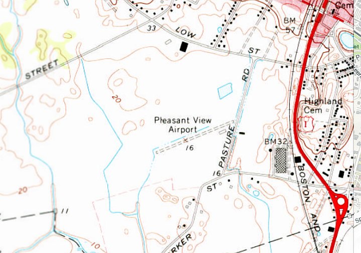
The earliest topo map depiction which has been located of Pleasant View Airport was on the 1968 USGS topo map.
It depicted Pleasant View Airport as having an unpaved 1,700' northeast/southwest runway, with 1 small building on the southeast side.
According to Undercurrents, the Reardon brothers purchased the airport land in the late 1960s.
A 1971 aerial view showed Pleasant View Airport remained intact, but there were no aircraft visible on the field.
A 1978 aerial view showed the Pleasant View Airport hangars had been removed at some point between 1971-78.
According to Undercurrents, the state installed water & gas in the area, making the land became more valuable, and it was reportedly sold off to be developed by the late 1970s.
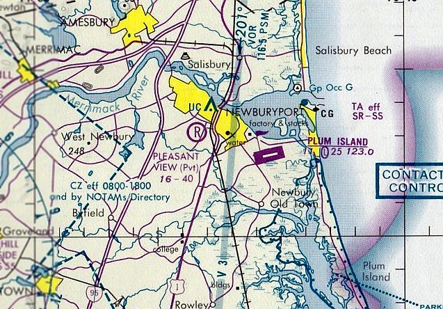
The last aeronautical chart depiction which has been located of Pleasant View Airport was on the June 1981 Boston Terminal Aeronautical Chart (courtesy of Ron Plante).
It depicted Pleasant View as a private airfield, with the runway having been lengthened considerably to 4,000'.
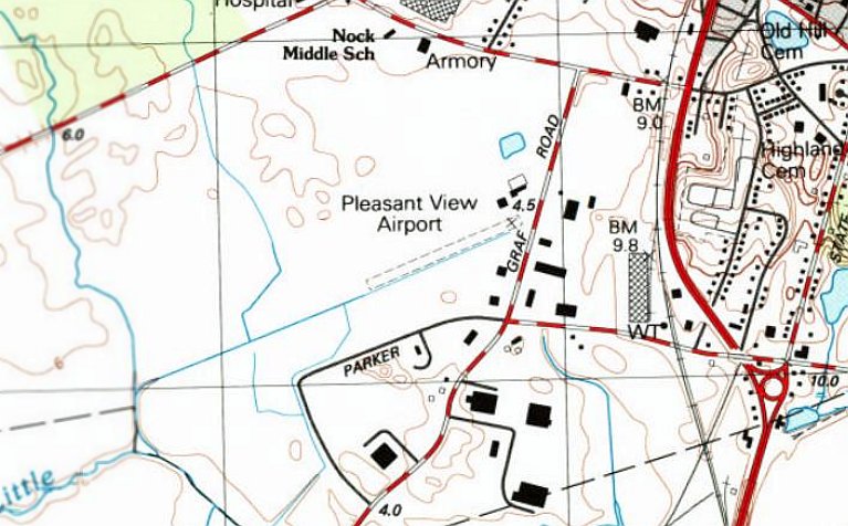
The last topo map depiction which has been located of Pleasant View Airport was on the 1988 USGS topo map.
It depicted Pleasant View Airport as having an unpaved 1,700' northeast/southwest runway, with several small buildings on the east side.
Pleasant View Airport was evidently closed at some point between 1981-92,
as it was no longer depicted on the 1992 Boston Terminal Aeronautical Chart.
A 1995 aerial view showed a building had been built over the southwestern portion of the former Pleasant View Airport runway.
The 2012 USGS topo map no longer depicted Pleasant View Airport, instead showing several roads having been built on the site.
A 2018 aerial view showed no trace remaining of Pleasant View Airport, with the site occupied by industrial buildings.
Thanks to Paul Zahornasky for pointing out this airfield.
____________________________________________________
Ten Pound Island Coast Guard Air Station, Ten Pound Island, MA
42.6, -70.66 (Northeast of Boston, MA)
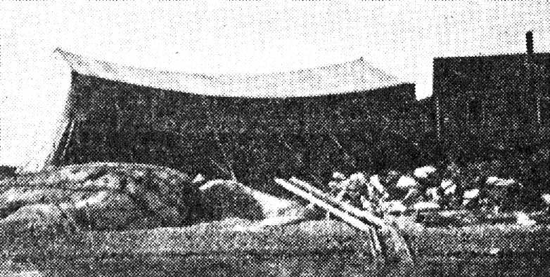
An undated photo of Ten Pound Island Air Station from the January 1941 issue of Coast Guard Magazine,
captioned, “This ancient tent housed the first planes of 1925.”
LCDR Carl Von Paulsen, an aviator, was the commanding officer of Section Base #7 located Gloucester, MA.
Paulsen approached LCDR Stephen Yeandle, aide to Commandant Billard, with the idea of utilizing aircraft to locate boats used for prohibition running.
Yeandle thought the concept had merit & approached the Commandant who approved the idea but no funds were available.
A Navy surplus UO-1 was located & an agreement was made for the Coast Guard to utilize it for a period of a year.
It initially flew out of the Squantum Naval Reserve Air Station, but then transferred to a makeshift tent-hangar located on Ten Pound Island in Gloucester Harbor.
The first use of an aircraft to chase a rum-runner was on 6/20/25.
The UO-1 assisted in the first capture of a rum-runner with aviation support on 6/24/25.
Von Paulsen & veteran aviator Leonard Melka flew many thousands of miles on patrol during the first year locating smugglers from the air & directing the patrol boats to them.
The experience obtained from operating this single airplane convinced Headquarters of the advantages derived from the use of aircraft in Coast Guard work
and it was decided to establish a permanent air station & procure appropriate aircraft.
Coast Guard Commandant Admiral Billard, obtained an appropriation of $162,000 for the purchase of 5 aircraft specifically designed for the Coast Guard.
Three were modified Loening OL-5 amphibians with strengthened hulls for rough water landings & larger fuel tanks providing increased fuel for extended law enforcement patrols.
Two of the aircraft purchased were modified Vought UO-1 seaplanes designated as UO-4s.
During the summer of 1926 after blasting, leveling & concrete pouring, a large steel hangar was erected.
The first OL-5 aircraft arrived at Ten Pound Island on 10/14/26, and another arrived on 11/3/26.
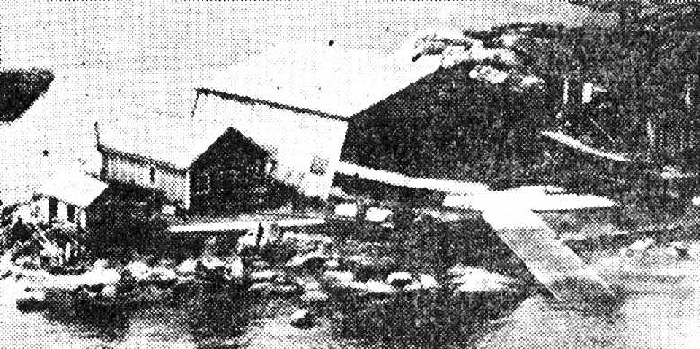
An undated photo of Ten Pound Island Air Station from the January 1941 issue of Coast Guard Magazine,
captioned, “The personnel of Base Seven erected this wooden hangar at a cost of $5,000."
The Coast Guard went on the offensive & the 3 mile limit was effectively extended by means of agreements with other nations.
Smuggling interdiction continued to be the primary mission of the Air Station.
Daily patrols were flown in aircraft not only capable of radio communication with both surface units & shore stations
but with the ability to obtain the bearing of a black making a radio transmission.
The OL-5s were armed with machine guns and, at least in one recorded incident,
they were used to sink numerous wooden crates of whiskey that were dumped overboard by a rum-runner.
As rum-row continued to move further off shore & the search area continued to expand, the most effective utilization of the aircraft was to locate a boat,
notify Coast Guard surface vessels of its location, and to continue to circle over the boat until a destroyer or 75 footer arrived on scene to apprehend or commence picket duty.
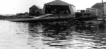
An undated photo of Ten Pound Island Air Station, showing a seaplane inside the hangar.
The station was simultaneously engaged in the saving of life & property.
In the first 4 years of operation there were 212 cases of assistance rendered embracing casualties to vessels, property & persons.
Experiments were conducted in which a shot line, strung between poles, was picked up by the aircraft & carried to a vessel in distress.
The line was dropped from the plane to the deck of the vessel in distress & a breaches-buoy is run out to the vessel and survivors are brought ashore by this means.
It was used when the vessel in distress was too far from shore for the shot line to reach it or the seas were too rough for the launching of a small boat.
By 1932 (or later) a JF-2 was assigned to Ten Pound Island.
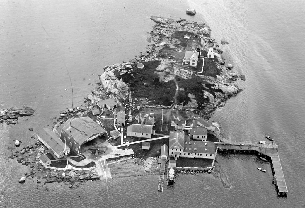
A 1934 USCG aerial view looking southwest at Coast Guard Air Station Ten Pound Island (courtesy of John Keyes).
John Keyes observed, “The Air Station was on the southeast corner of the island; the large hangar & several outbuildings were clustered around the seaplane ramp.
The building complex with 2 boat ramps & a large pier was a U.S. Fisheries lobster hatchery that pre-dated the Coast Guard station.
Towards the south end of the island is the lighthouse keeper's residence.
The Vought UO-4 designated 'CG-405' - one of the 5 aircraft first purchased by the Coast Guard in 1926 - sat just outside the hangar.”
With the advent of the PJ & RD Dolphin flying boats there was no room to expand the Ten Pound Island base.
Ten Pound Island Air Station was decommissioned & a new air station was established at Salem in 1935.
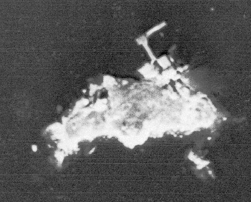
An 11/21/38 USGS aerial view of Ten Pound Island showed the remnants of the Coast Guard Air Station on the southeast side.
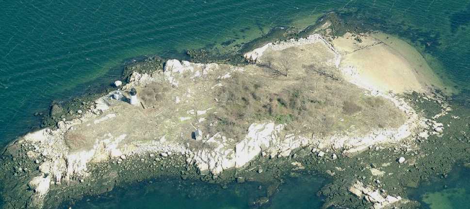
A circa 2008 aerial view looking north at Ten Pound Island shows a lighthouse & a small building on the island, along with a seawall on the northeast side.
There does not appear to be any remnant of the Coast Guard Air Station on the southeast corner of the island.
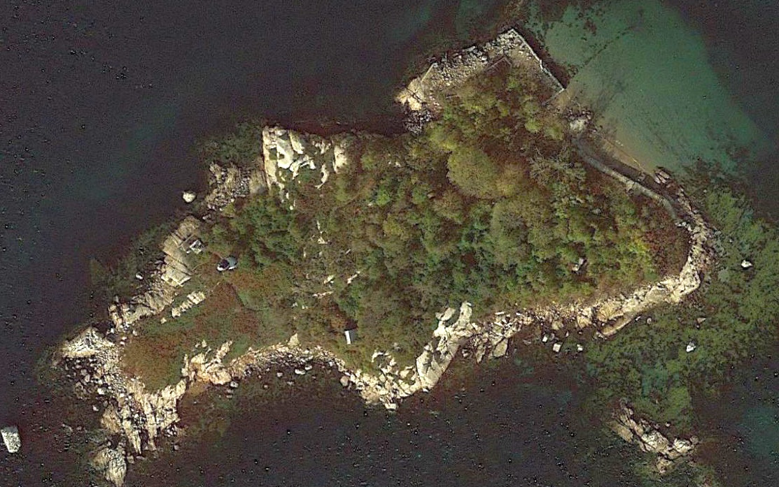
A 2020 aerial of Ten Pound Island shows the seawall on the east side appears to be the only trace of the Coast Guard Air Station.
Thanks to Kevin Rutherford for pointing out this Air Station.
____________________________________________________
42.611, -71.29 (Northwest of Boston, MA)
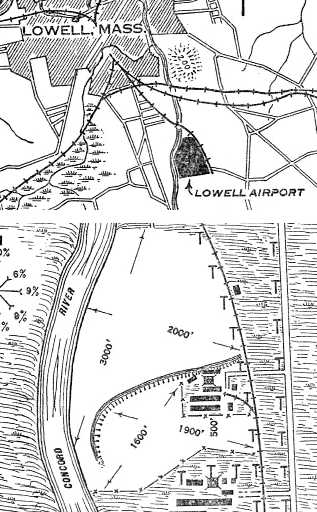
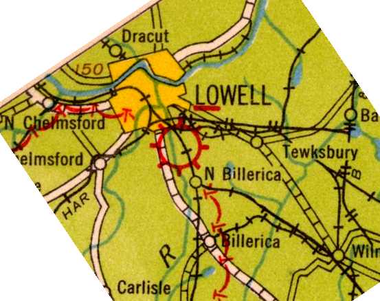
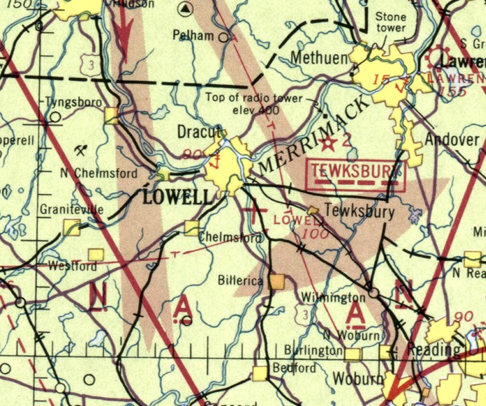
The location & layout of Lowell Airport, as depicted on the 1928 Department of Commerce Airway Bulletin (courtesy of Jonathan Westerling).
Jonathan Westerling reported, “Lowell, Massachusetts had its busiest days as a pioneering textile mill town in the late 1800s.
Even though the city’s industries were in decline by the late 1920s,
it managed to attract a major aircraft manufacturer & enjoyed a short time in the national aviation spotlight.
The Lowell Airfield dates back to 1928 when Edith Rogers
(one of the first women to serve in the United States Congress & the longest-serving Congresswoman in US History)
began a movement to establish an airport in her home city.
She enlisted the assistance of one of her congressional predecessors, General Butler Ames.
Gen. Ames had assumed leadership of the United States Cartridge Company after serving 5 terms in the US Congress.
In 1926, his company was sold & relocated to the Winchester Repeating Arms Company of Bridgeport, Connecticut.
This left Gen. Ames with a large vacant factory & unused land along the Concord River in South Lowell.”
Jonathan continued, “Working with Congresswoman Rogers, Ames established the Lowell Airport Corporation
and cleared the land adjacent to his plant for the airfield undoubtedly thinking that the addition of an airfield on his property
would help him attract a manufacturing company associated with the new & expanding field of aviation.
Less than a year later this would prove to be the case.”
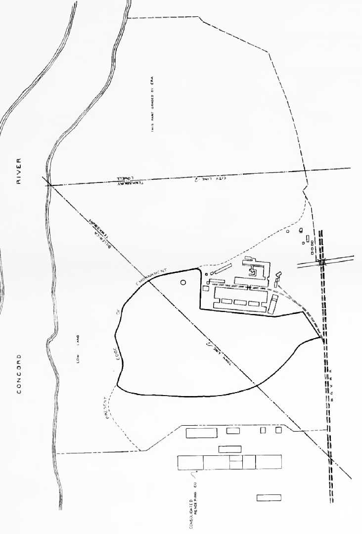
Jonathan continued, “The airfield was 120 acres and was located on the east bank of the Concord River.
The airport land had a lower area next to the river & a higher area on a 20' bluff overlooking the river.
According to the lease for the property (courtesy of the Ames Family Archives at Smith College)
the Lowell Airport Corporation secured use of the property & the buildings on it for 30 years at the price of a dollar per year!
The northern part of the airfield was on low lands & had a 3,000' x 2,000' landing area.
The southern half of the airfield was up on a 20’ embankment & was therefore more solid ground,
but had a smaller 1,900' x 1,600' landing area.”
The earliest depiction of the field which has been located
was on the 1928 Department of Commerce Airway Bulletin (courtesy of Jonathan Westerling).
It depicted Lowell Airport as having a 1,900' x 1,600' landing area on the higher ground on the southern half,
a 3,000' x 2,000' landing area on the lower ground to the north, and the factory buildings on the east side.
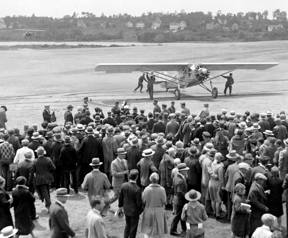
A 2/621/28 photo of the arrival of Mexican goodwill flyer Captain Emilia Caranza in the 'Mexico-Excelsior' aircraft, a Ryan Brougham Monoplane at Lowell Airport
(courtesy of the Boston Public Library, Leslie Jones Collection).
Jonathan Westerling reported, “Dedication of the airfield occurred on 6/21/28.
According to an article in the Associated Press, 5,000 people attended the ceremony
which featured stunt flying & the arrival of Captain Emilio Carranza, a famous Mexican goodwill flyer.”
According to Jim Roy, “Captain Carranza's plane landed from the west across the river, turned near Woburn Street & taxied back around the strip.”
Jonathan Westerling reported, “According to a personal letter from General Ames’ Sister Blanche (courtesy of the Ames Family Archives at Smith College)
the dedication was advertised in the Boston Subways & was to feature a visit from the U.S. airship Los Angeles.
The airship’s trip was canceled at the last-minute due to bad weather in New York.”
Jonathan continued, “In 1929, the Moth Aircraft Company announced Lowell Airport as the site of its manufacturing facility.”
A 1/3/29 article in the Associated Press reported that “One of the largest airplane manufacturing plants in the country will begin operations [in Lowell] shortly,
for the construction of the ‘D.H. Moth’ type airplanes.
The new concern will adjoin the Lowell Airport & will employ 200 workers at first...
The proposed factory will occupy 90,000 square feet of floor space.”
Jonathan Westerling reported, “The Moth factory was quickly set up in the plant building on the northeast corner of the upper part of the airfield
and was soon producing DeHavilland Moth DH 60M biplanes
which were some of the first planes to be commercially produced with a metal (thus the M designation) instead of wooden structure.”
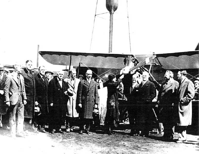
A circa 1929-31 photo of the “christening” of a new DH Moth Biplane at the Lowell Airport (courtesy of Jonathan Westerling).
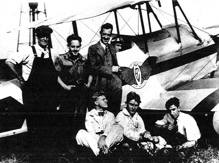
A circa 1929-31 candid shot of pilots in front of a Moth outside the Lowell plant (courtesy of Jonathan Westerling).
According to Jonathan, “The pilot at the controls is believed to be Moth test pilot Ronald Smith.”
According to a March 2005 Air Classics article by Gilles Auliard, “The Moth Aircraft Corp. of Lowell
was incorporated in 1928 to manufacture the DH Moth under license.
Several airplanes were brought over from England for test & demonstration.
Production of the American version of the Moth started in the early summer of 1929.
By November of that year, over 120 had been built...
The type certificate (ATC #197) for the models 60GM & GMW was issued in August 1929 for both the land & seaplane version.
179 examples of the Moth were built at the Moth Aircraft Corporation & the Moth Aircraft Division between 1929-31,
when all production stopped because of lack of sales [due to the Great Depression].”
According to Jonathan Westerling, “By 1931, the Curtis-Wright Corporation bought the Moth operation
and moved the manufacturing of the DeHavilland planes to its Robertson, Missouri plant.
Despite loosing its high-profile tenant, the Lowell airport continued operation throughout the Depression.”
The 1931 Department of Commerce Airway Bulletin #2 (according to Jonathan Westerling)
described Lowell Airport as having a 1,500' east/west runway & a 4,000' x 2,000' gravel landing area (the lower landing area).
According to Jonathan Westerling, “However the lower half of of the airfield fell into disuse in 1932,
as that year’s [Department of Commerce Airway] Bulletin #2 listed only the higher south portion of the field as usable.
A landing strip was added on this portion of the airfield with the dimensions of 1,800' x 600'.
This configuration persisted through the airports closure.”
The earliest aeronautical chart depiction which has been located of the Lowell Airport
was on the 1933 Army Air Corps Flight Chart (courtesy of Jonathan Westerling).
The 1937 “Second Annual Progress Report of the Committee for Aeronautics of the Commonwealth of Massachusetts” (courtesy of Jonathan Westerling)
described Lowell Airport as having a 40’ square metal hangar with an adjoining office building.
The operator was listed as the Creamer Flying Service.
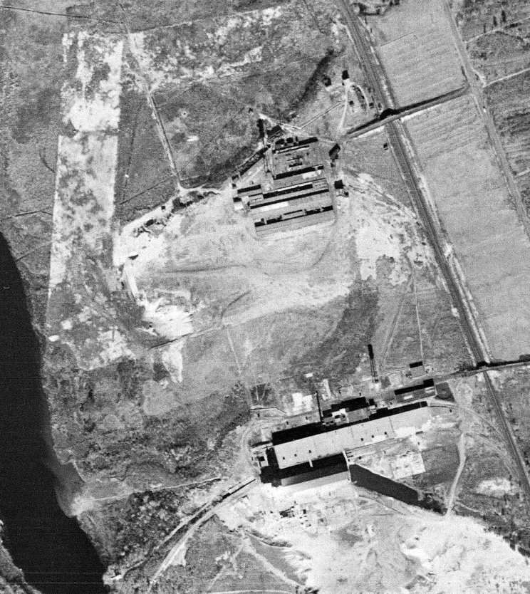
The last photo which has been located of the Lowell Airport was an 11/10/38 USGS aerial view.
It depicted an open area in between 2 clusters of industrial buildings, and possibly an unpaved north/south runway on the west side.
According to Jonathan Westerling, “In 1940, aircraft manufacturing returned to the Lowell Airport.
The General Aircraft Corporation set up to build the G1-80 Skyfarer, a 2-seat cabin high-wing braced monoplane similar to the Ercoupe.
But before the company could produce the aircraft in any numbers,
the Second World War intervened & the Skyfarer program was abandoned.
According to the book “Ercoupe – A Touch of Class”, there were only 17 Skyfarers built.
The General Aircraft Corporation went on to become a manufacturer of the Waco CG-4A troop glider during the War,
however this work was done on Long Island.”
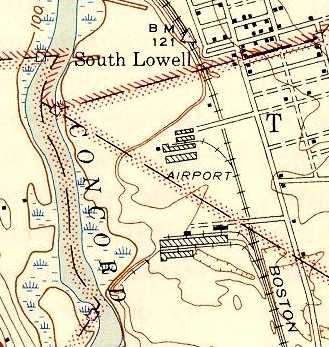
The 1941 USGS topo map (courtesy of Jonathan Westerling) depicted the Lowell buildings of the General Aircraft Corporation
with the property labeled simply as “Airport”.
The last depiction which has been located of Lowell Airport was on the February 1942 Boston Sectional Chart,
which depicted Lowell as an auxiliary airfield.
The Lowell airport presumably closed at some point between 1942-43,
as it was no longer depicted on the February 1943 Boston Sectional Chart.
Jonathan Westerling reported, “The Lowell Airport Corporation continued in existence until 1947 (according to their corporate records courtesy of Smith College)
when the officers decided to dissolve the company.”
A 1971 aerial photo showed that a much larger industrial building
had been added to the west side of the former aircraft factory at some point between 1941-71.
A 1978 aerial photo showed that former aircraft factory on the east side of the property had been removed at some point between 1971-78
(with only the more-modern larger building remaining on the west side of the site),
removing the last specific trace of the aviation history of this property.
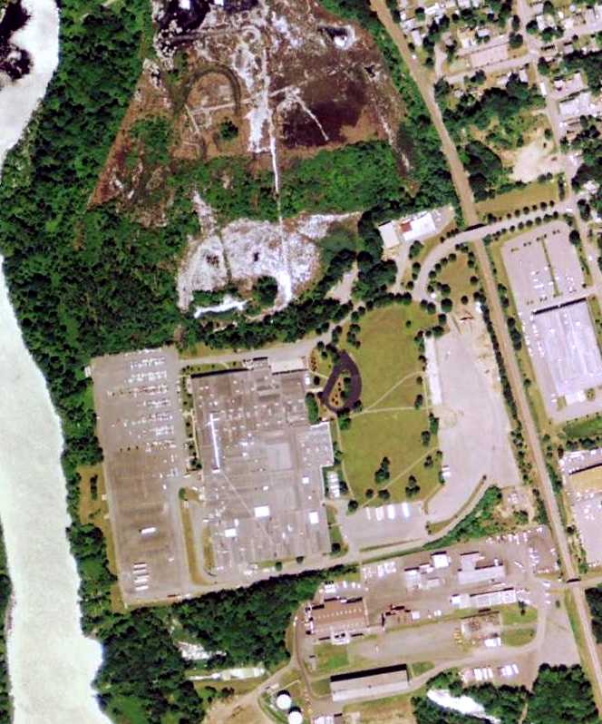
A 7/16/08 aerial view showing a large industrial building covering the site of Lowell Airport.
Jim Roy reported in 2012 of the Lowell Airport site, “I took a ride by there & found the site to be just too overgrown now with vegetation.
There is almost no recognizable area left or vantage point to even suggest what was there 70+ years ago.”
A 2019 aerial photo showed the large industrial building still covering the site of Lowell Airport.
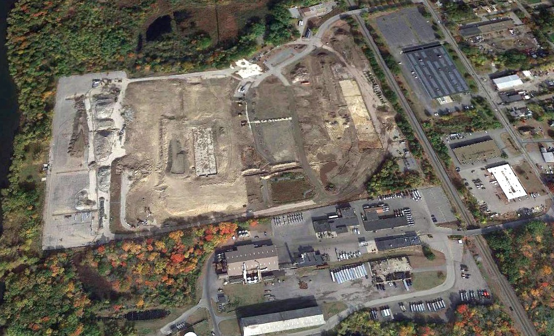
A 2020 aerial view looking north showing the large industrial building covering the site of Lowell Airport had been removed at some point between 2019-2020.
The site of the Lowell Airport is located at what is now the Riverview Commerce Center business park,
southwest of the intersection of Woburn Street & Commonwealth Avenue.
____________________________________________________
Haverhill Dutton Airport (8B6), Haverhill, MA
42.8, -71.06 (North of Boston, MA)
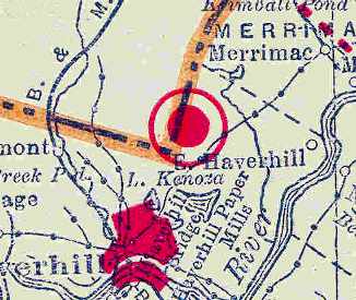
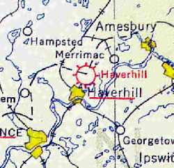
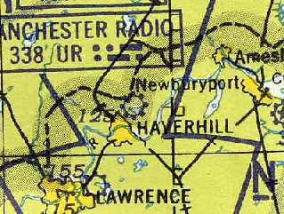
Haverhill Airport, as depicted on the 1929 Rand-McNally Air Trails Map of Massachusetts (courtesy of Chris Kennedy).
Not to be confused with the nearby Haverhill Riverside Airport,
the former Haverhill Dutton Airport is located northeast of the town of Haverhill, just south of Interstate 495.
The date of construction of Haverhill Dutton Airport is unknown.
The earliest depiction of the field which has been located
was on the 1929 Rand-McNally Air Trails Map of Massachusetts (courtesy of Chris Kennedy).
It described Haverhill Airport as a commercial field, operated by E. L. Walker & H. P. Fall.
The field was said to be 3,000' x 2,000' in size.
The Airport Directory Company's 1933 Airport Directory (courtesy of Chris Kennedy)
described Haverhill as a commercial airport, located "2 miles northeast of the business section, near Lake Kenosa."
The field was said to consist of an irregularly-shaped 75-acre sod field, measuring 1,600' x 1,400'.
Haverhill Airport, as depicted on the 1934 U.S. Navy Aviation Chart (courtesy of Chris Kennedy).
The 1937 “Progress Report of the Committee For Aeronautics of the Commonwealth of MA” (courtesy of Jonathan Westerling)
depicted Haverhill Airport as an irregularly-shaped 53 acre sod field,
within which were 4 gravel runways, the longest being the 1,800' northwest/southeast strip.
It was described as a commercial airport, owned by E.L. Walker & operated by F.P. Johnson & George Monoquian.
There were no hangars, the only building being a wooden office building.
The earliest photo which has been located of Haverhill Airport was an 11/1/38 USGS aerial view.
It depicted Haverhill as an irregularly-shaped unpaved airfield area with a few small buildings (and possibly one light plane) on the west side.
An aerial view looking south at "Haverhill" Airport
from The Airport Directory Company's 1941 Airport Directory (courtesy of Chris Kennedy).
The directory described Haverhill as consisting of an irregularly-shaped 90-acre sandy loam area.
The November 1942 Regional Aeronautical chart (courtesy of Chris Kennedy) depicted "Haverhill" as a commercial airport.
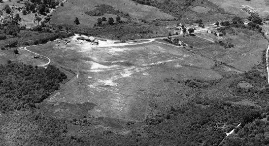
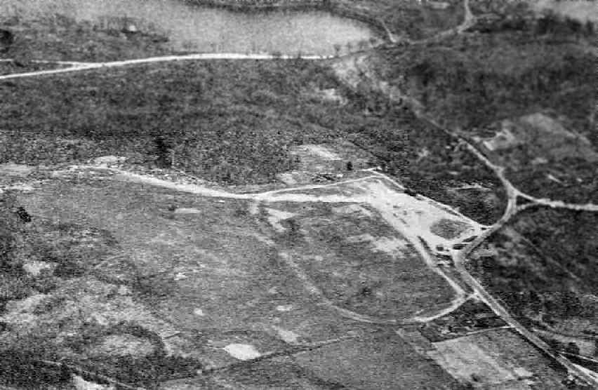
A July 1946 aerial view looking northwest at Haverhill Airport (from the MA Aeronautics Commission)
depicted Haverhill as an irregularly-shaped unpaved airfield area with a few small buildings on the west side.
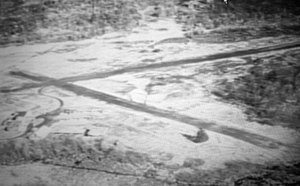
A circa 1950s aerial photo looking east depicted Haverhill Dutton as having 2 runways.
The 1959 Boston Local Aeronautical Chart (courtesy of Chris Kennedy)
depicted Haverhill Airport as having a 1,700' unpaved runway.

"Haverhill" Airport, as depicted on the 1962 Boston Local Aeronautical chart (courtesy of Mike Keefe).
The 1962 AOPA Airport Directory listed the field under the name of "Haverhill (Dutton)" Airport,
and described it as having two 1,600' sod runways: 15/33 & 3/21.
The operator was listed as Howard Dutton.
The Aerodromes table on the 1965 Boston Sectional Chart (courtesy of John Voss)
described the field in much the same configuration.
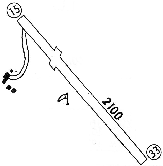
The 1968 Flight Guide (courtesy of Robert Levittan) depicted Haverhill
as having a single 2,100' unpaved Runway 15/33, with 4 buildings on the west side.
Haverhill evidently gained a paved runway at some point between 1965-68,
as the 1968 Boston Sectional chart (courtesy of Mike Keefe) depicted "Haverhill" Airport as having a single 2,100' paved runway.
A 1971 aerial photo depicted Haverhill Dutton as having a northwest/southeast runway, along with the remains of a former north/south runway.
Several small hangars were on the west side of the field, around which were parked 14 light aircraft.
The last aeronautical chart depiction which has been located of Haverhill Airport
was on the June 1975 Boston Terminal Aeronautical Chart (courtesy of Mitchell Hymowitz).
It depicted Haverhill as having a 2,100' paved runway.
According to an article in the 3/4/98 issue of the Lawrence Eagle-Tribune (courtesy of Jonathan Westerling),
Howard Dutton, was a renowned aerobatic pilot.
Tragically, he perished in 1977 when his plane crashed into his own airport as he was flying inverted.
Richard Cowan recalled, “Haverhill Dutton Airport... I trained at this funky airport in the late 1970s.
I couldn’t afford the rates at the fields closer to Boston.
The rough & ready Dutton family owned the place & ran their flight training, rental & charter business from their living room.
A large female relative - mother, grandmother, aunt? - was always there smoking cigarettes & watching TV.
Sometimes family arguments would erupt as I was trying to get my logbook signed or a lesson paid for.
After getting my license, I kept a series of $4,000 planes in one of their tumbledown hangars.
Among them was an underpowerered 1946 Aeronca Chief 11AC.
Given even a modest headwind & at full throttle it couldn’t keep up with traffic on the the interstate highway.”
Richard continued, “Patriarch Howard Dutton was a barnstormer who dazzled airshow crowds around New England in the 1950s
by landing his Cub on a platform on the roof of a panel van racing down the runway.
Sadly, he died while flying inverted a few feet over his own airstrip.
I recall Howard berating me re some dangerous assumption I’d made:
'Don’t assume nothing! ASSUME makes an ASS out of You & Me!'
Approaches to this relatively short field demanded full attention due to high tension power lines, hills, untrimmed trees and the close proximity of Interstate 495.
There was also a distracting cemetary to remind you of your fate should you fall afoul of any of these obstacles.”
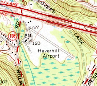
The 1977 USGS topo map depicted Haverhill Airport as having a paved northwest/southeast runway with few small buildings on the west side.
Dave Dantos recalled "I took my first lessons at Dutton, in 1979.
By then, there was a paved runway, and an adjacent, parallel, grass runway.
Departure from Dutton was generally (and maybe always) westbound, over a string of high tension wires, and Route 495.
If that was not unnerving enough for a new student, the arrival was (still westbound, of course) over a small hill.
Essentially, it was necessary to match the slope of the hill, on final."
Denise Jeffreys recalled, “I took a lot of flying lessons with Howie Dutton at his airstrip in Haverill.
I kept my plane in Hanscom, but going into his strip was quite exciting after doing touch & goes at nearby Lawrence Airport.
Howie did not like pilots who made the notch in the trees on the approach to his strip a little deeper by bringing back some branches in the gear.
He told you that you should damn well do better than that. Those were fun days I am trying to remember.
I must have been flying the [Cessna] 150 when I was going into the Haverhill strip.
I believe that the strip was not paved at that time.”
The 1982 AOPA Airport Directory (courtesy of Ed Drury) described Haverill Dutton as having a single 2,100' asphalt & gravel Runway 14/32.
The former Runway 3/21 was apparently abandoned. Services offered included hangar storage, charter, flight instruction, and plane rental.
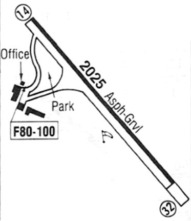
The last depiction which has been located showing Haverhill Airport in operation was in the November 1983 Flight Guide (courtesy of Matt Elia).
It depicted Haverhill as having a 2,025' paved Runway 14/32, with an office & 3 small buildings on the west side.
According to the assessor's office, the property changed hands in 1983 from David Dutton (Howard Dutton's son) to 129 Realty Trust.
Plans to convert the land into an aquaculture farm were dashed because of pollution from years of use.
According to the Lawrence Eagle-Tribune, Haverhill Airport closed in approximately 1986.
Haverhill Airport was no longer depicted at all on the December 1986 NY Sectional Chart (courtesy of Kevin O'Reilly).
Haverhill Airport was labeled "Airport (Abandoned)" on the 1987 USGS topo map.
A 1992 aerial view looking northeast showed Haverhill Dutton's runway was marked with closed-runway “X” symbols but its runway numbers remained.
Since the field was closed, there have been a few episodes of pilots landing at the field,
either due to being lost, or in emergencies.
In 1998, a veteran flying instructor & a student pilot on a check flight walked away from their Cessna
after it crashed into a thicket of trees next to the old Dutton Airport.
Police said flight instructor Colin Cressman & student pilot Gretchen Aleman
had just taken off from Lawrence Airport.
When they reached 2,000 feet, the plane developed engine trouble.
Lawrence Airport contacted Haverhill that the plane would attempt to land
on the seldom used runway at the old Dutton Airport.
"It was too short," Deputy Fire Chief John Landers said.
"The plane was full of fuel, over-shot the runway, became airborne & nosed into the woods."
Approach paths from both sides have been obstructed significantly by trees over the years.
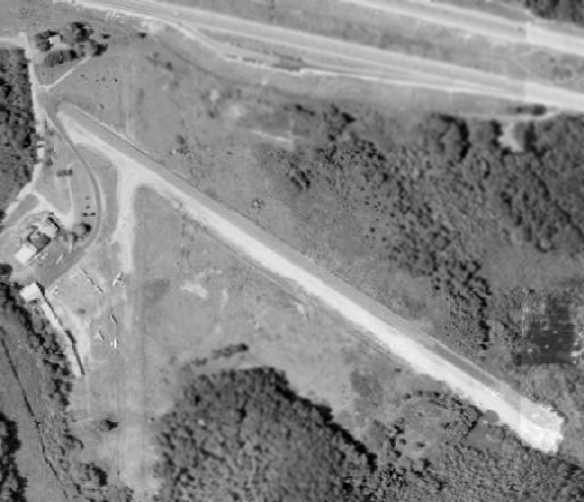
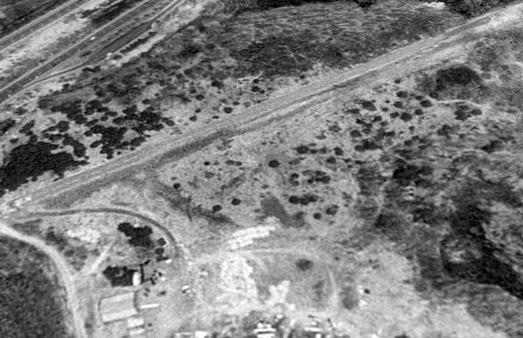
The 1998 USGS aerial photo of the former airport showed that the runway had remained in fairly good condition,
and at least one hangar was still standing, just west of the runway.
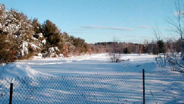
A 2002 photo by Jonathan Westerling of a snowy scene, looking along the former runway at Haverhill Dutton Airport.
Jonathan Westerling visited the former airfield in 2002, and reported that it was no longer visible from the 495 rest stop.
The runway was still visible from Newton Road, though.
He also reported that the former "hangar" still stood, although it looked more like a typical barn.
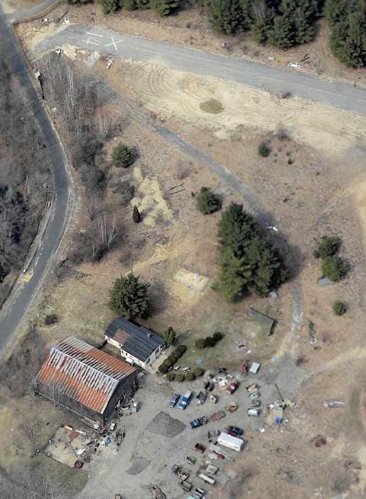
A circa 2005 aerial photo looking north at the former Haverhill Runway 14, and the hangar at the bottom.
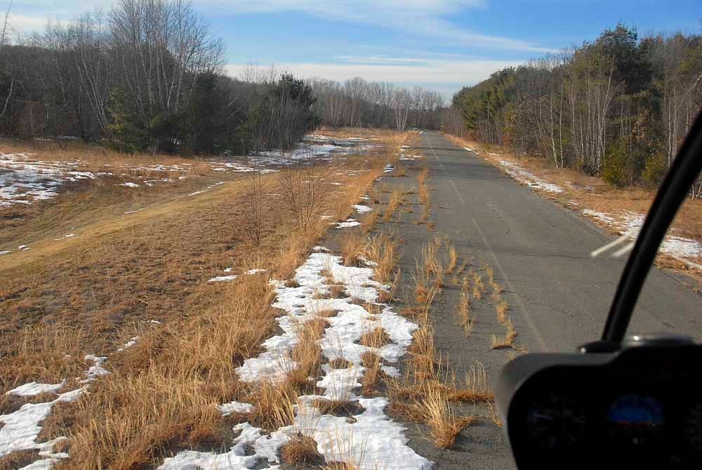
A circa 2011 aerial view looking northeast along the remains of Haverhill Dutton Airport's Runway 32, during an off-airport training helicopter landing.

A 5/25/14 photo looking along Haverhill-Dutton's abandoned runway.

A 2018 aerial view looking northeast showed Haverhill Dutton's paved runway remained intact though deteriorated,
and the hangar also remained standing west of the runway.

A 1/2/22 photo of Neal Ivester on the remains of Haverhill-Dutton Airport's Runway 14.
Neal reported, “The airfield pavement remains intact & markings are still visible.
The vegetation has grown-in significantly over the last 20 years & it could not even serve as an emergency landing site; adjacent I-495 would be a much safer choice.
The last hundred feet of runway on the 32 end is slowly being taken over by the adjacent swamp as well.”
Haverhill Dutton Airport is located southeast of the intersection of Interstate 495 & Newton Road.
A rest area on the south side of Interstate 495 sits adjacent to the north side of the airfield, from which the airfield used to be visible.
____________________________________________________
Haverhill Riverside Airport & Seaplane Base (MA04), Haverhill, MA
42.77, -71.03 (North of Boston, MA)
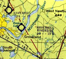
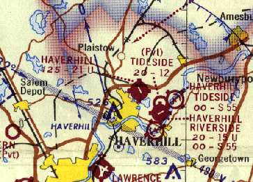
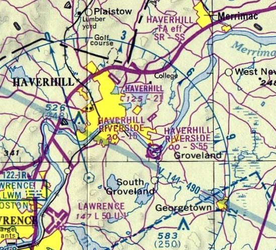
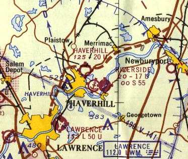
Haverhill Riverside Airport, as depicted on the 1960 Boston Local Aeronautical chart (courtesy of Mike Keefe).
Not to be confused with the nearby Haverhill Dutton Airport,
the former Haverhill Riverside Airport & Seaplane Base is located southeast of the town of Haverhill,
along the northern bank of the Merrimack River.
Haverhill Riverside Airport was apparently built at some point between 1959-60,
as it was not depicted on the 1959 Boston Local Aeronautical Chart (courtesy of Chris Kennedy).
The earliest reference to the field which has been located
was on the 1960 Boston Local Aeronautical chart (courtesy of Mike Keefe).
It described Haverhill Riverside Airport as having a single 1,900' turf runway.
The 1961 Boston Local Aeronautical chart (courtesy of Mike Keefe) described Haverhill Riverside Airport in the same manner.
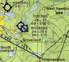
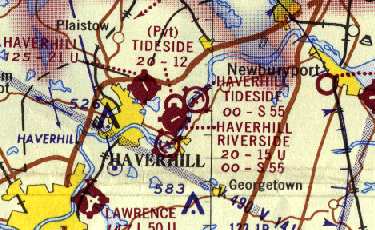
Within the next year, a "Haverhill Tideside" Airport apparently opened,
as it was depicted just to the northwest of Haverhill Riverside Airport
on the 1962 Boston Local Aeronautical chart (courtesy of Mike Keefe).
The Aerodromes table on the chart continued to describe Haverhill Riverside as having a single 1,900' turf runway,
while the new Haverhill Tideside Airport was described as having a single 1,300' turf runway.
The 1962 AOPA Airport Directory described Haverhill Riverside as having a single 1,900' sod Runway 9/27.
The operator was listed as William Slavit.
The seaplane base was described as having a 7,000' water landing area.
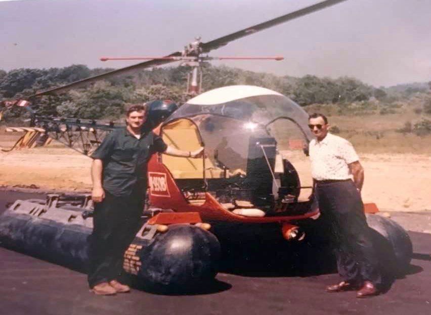
The earliest photo which has been located of Haverhill Riverside Airport was a 1964 photo (courtesy of Ron Janard) of Red Slavit & George “Chip” Germaine in front of a Bell 47 G-2A helicopter with fixed floats.
Red Slavit had just returned to Riverside Airport after finding the military pilot in the river who had ejected from a jet fighter that crashed on Lackey Street, and Chip served as the observer to help find the pilot.
Sometime within the next three years, the runway at Haverhill Riverside was apparently paved,
as the Aerodromes table on the 1965 Boston Sectional Chart (courtesy of John Voss)
described the field as consisting of a single 1,700' asphalt runway.
The seaplane base was described as having a 5,500' water landing area.
The adjacent Haverhill Tideside Airport was evidently closed at some point between 1962-65,
as it was no longer depicted at all on the 1965 Sectional.
The Haverhill Riverside Airfield & Seaplane Base
were depicted on the 1968 Boston Sectional chart (courtesy of Mike Keefe).
Strangely, the adjacent Haverhill Tideside Airport had "reappeared" on the chart.
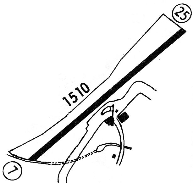
The 1968 Flight Guide (courtesy of Robert Levittan) depicted Haverhill Riverside
as having a single 1,510' paved Runway 7/25, with 2 buildings on the southeast side.
The earliest aerial photo which has been located of Haverhill Riverside Airport was a 1971 aerial view.
It depicted the field as having a single northeast/southwest runway,
with a few small buildings & hangars on the southeast side, and 5 single-engine aircraft.
The June 1975 Boston Terminal Aeronautical Chart (courtesy of Mitchell Hymowitz)
depicted Haverhill Riverside as having a 1,500' paved runway.
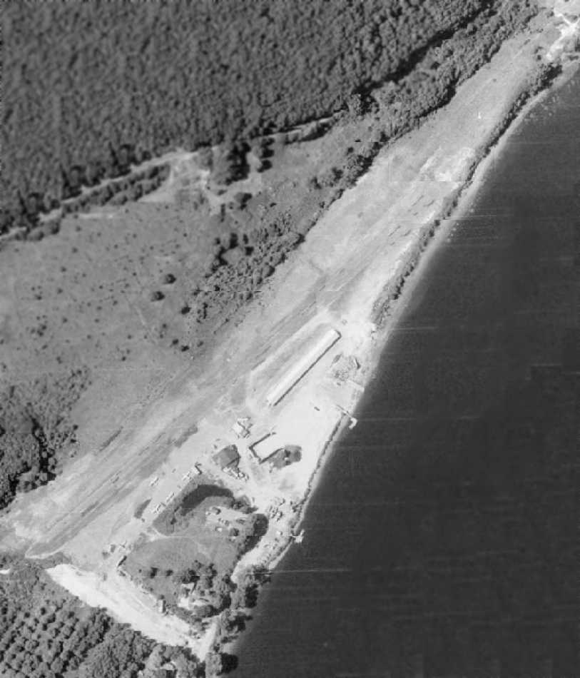
A 4/23/78 USGS aerial view depicted Haverhill Riverside Airport as having a single northeast/southwest runway,
with a few small buildings & hangars on the southeast side, and 6 single-engine aircraft.
Haverhill Riverside had become a private airfield by the time of the 1982 AOPA Airport Directory (courtesy of Ed Drury),
and the runway had been shortened, to a 1,510' asphalt Runway 4/22.
Steve Pustell recalled, "When I got my license in 1982,
I flew into the Haverhill Riverside airport in my 1969 Cherokee 180.
It was short but fun. As I recall it was not staffed then, but you could still fly in & land, and aircraft were based there.
To me it felt very much like a one way airport... landing approach & departing approach both over the river."
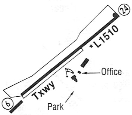
The November 1983 Flight Guide (courtesy of Matt Elia) depicted Haverhill Riverside as having a 1,510' paved Runway 6/24, with an office & 2 small buildings on the southeast side.
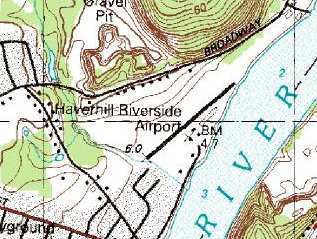
USGS topo map 1987.
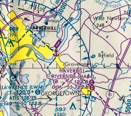
The last aeronautical chart depiction which has been located of Haverhill Riverside Airport
was on the December 1992 Boston Terminal Aeronautical Chart (courtesy of Gwen Shafer).
It depicted Haverhill Riverside as having a 1,600' paved runway.
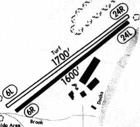
The 1994 Jeppesen Airport Directory depicted Haverhill Riverside as having 2 runways:
a 1,600' asphalt Runway 6R/24L & a 1,700' turf Runway 6L/24R.
Several hangars were depicted on the south side of the paved runway.
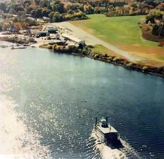
A 1994 aerial view looking west (courtesy of Ron Janard) depicted Haverhill Riverside Airport as having a single northeast/southwest paved runway,
with a few small buildings & paved ramp on the southeast side.
The excursion boat The Merrimac Queen was seen heading for the adjacent dock in the foreground.
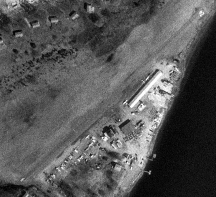
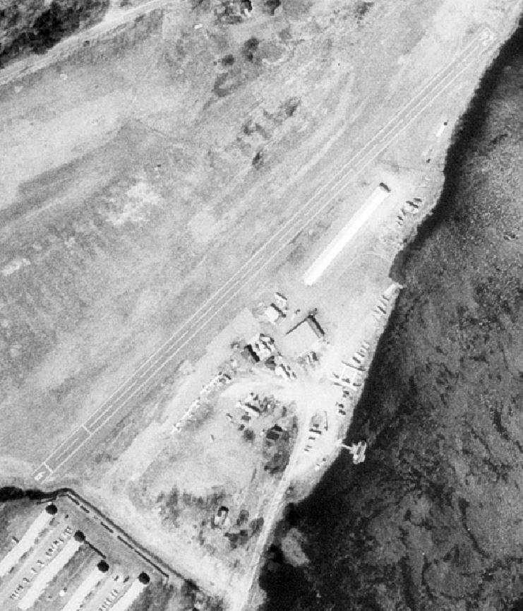
The last photo which has been located showing Haverhill Riverside Airport in operation was a 1995 aerial view.
It depicted the field as having a paved Runway 6/24, with a few small buildings & at least 3 light single-engine aircraft parked on the ramp.
Derrell Lipman recalled, "We nearly purchased a house right next to this airfield in late 1995, and it was still operating."
Haverhill Riverside Airport apparently closed at some point between 1995-98,
as it was depicted as a closed airfield on 1998 aeronautical charts.
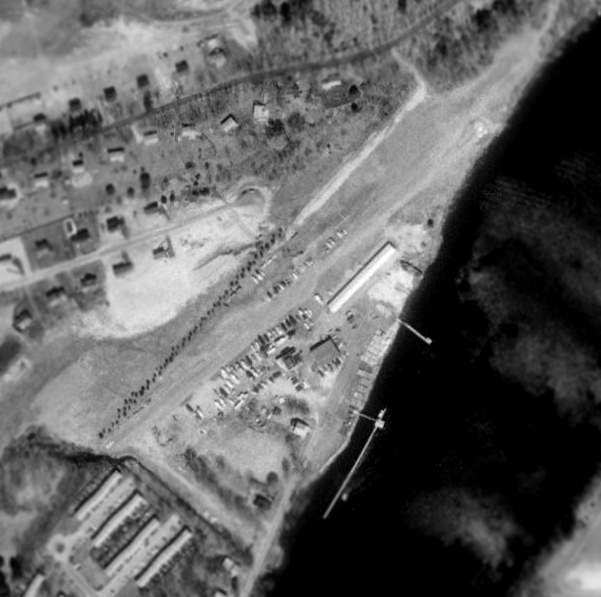
The 1998 USGS aerial photo of the former Haverhill Riverside Airport shows that it was still largely intact,
with the runway still undisturbed & the long hangar still standing.
However, an aerial photo from 2001 shows that significant changes had since taken place at the site,
with a long storage building having been built over the former runway.
Jonathan Westerling reported from a visit to the airport site in 2002:
"The property was purchased by a fellow who opened up a large marina & boat storage center on the spot.
The ramp still exists going down into the water.
The maintenance building has had its big main door converted into 2 smaller workshops [pictured above].
The runway area was covered (almost entirely!) with one long storage facility [pictured above].
The site is accessible off of Coffin Avenue (how appropriate?)."
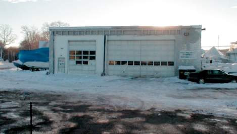
A 2002 photo by Jonathan Westerling of the former hangar of Haverhill Riverside Airport, now reused as a boat workshop.
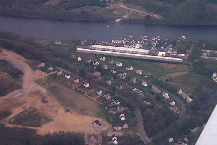
A 2003 photo by Lee Walus looking southwest at the site of Haverhill Riverside Airport.
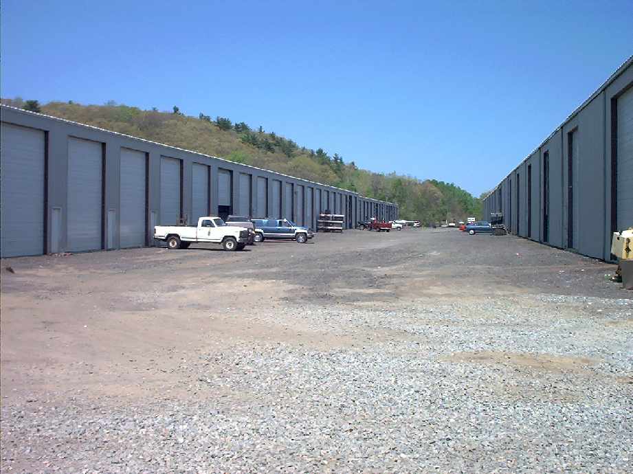
A 2003 photo by Lee Walus of the former runway area of Haverhill Riverside Airport, now covered almost entirely by long boat storage buildings.
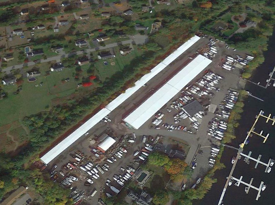
A 2020 aerial view looking north showed a storage building covering the former Haverhill Riverside Airport runway, but the former hangar remained in the center of the site.
The site of Haverhill Riverside Airport is located at the northeastern terminus of Coffin Avenue, along the northern bank of the Merrimack River.
Thanks to Lee Walus for pointing out this airfield.
____________________________________________________
Since this site was first put on the web in 1999, its popularity has grown tremendously.
If the total quantity of material on this site is to continue to grow,
it will require ever-increasing funding to pay its expenses.
Therefore, I request financial contributions from site visitors,
to help defray the increasing costs of the site
and ensure that it continues to be available & to grow.
What would you pay for a good aviation magazine, or a good aviation book?
Please consider a donation of an equivalent amount, at the least.
This site is not supported by commercial advertising –
it is purely supported by donations.
If you enjoy the site, and would like to make a financial contribution,
you
may use a credit card via
![]() :
:
Please consider checking the box to make a monthly donatation.
For a mailing address to send a check, please contact me at: paulandterryfreeman@gmail.com
If you enjoy this web site, please support it with a financial contribution.
please contact me at: paulandterryfreeman@gmail.com
If you enjoy this web site, please support it with a financial contribution.
____________________________________________________
This site covers airfields in all 50 states.