
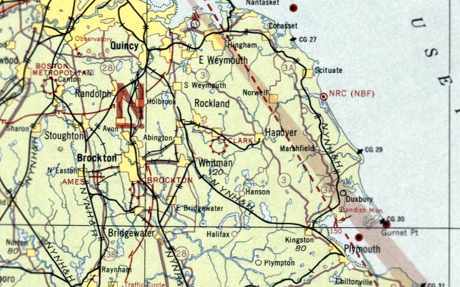
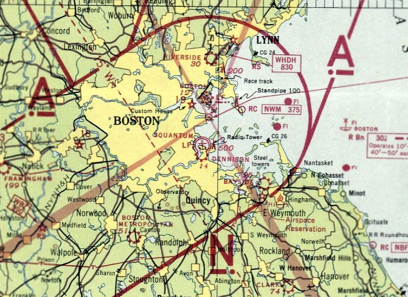
Abandoned & Little-Known Airfields:
Massachusetts: Southeastern Boston area
© 2002, © 2023 by Paul Freeman. Revised 11/21/23.
This site covers airfields in all 50 states: Click here for the site's main menu.
____________________________________________________
Please consider a financial contribution to support the continued growth & operation of this site.
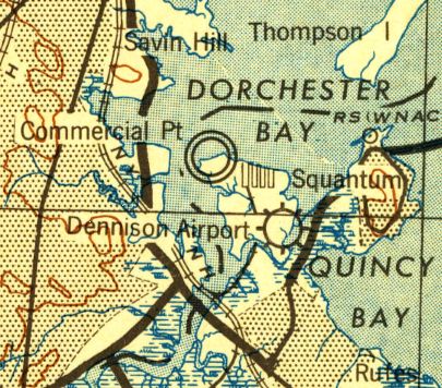
Bayside Airport (revised 1/22/19) - Boston City Heliport (revised 12/30/22) - Braintree Airport (revised 5/31/17) - Brockton Airport (revised 4/5/20) - Clark Airport (revised 4/5/20)
Dennison Airport (revised 9/27/22) - Harvard Aviation Field / Squantum NAS (revised 11/21/23) - South Weymouth NAS / Shea Field (revised 11/21/23)
____________________________________________________
Boston City Heliport (1MA3), Boston, MA
42.347, -71.044 (Southeast of Downtown Boston, MA)
Boston City Heliport, as depicted in the 1997 FAA report “Six Heliport Case Studies” (courtesy of Jonathan Westerling).
Jonathan Westerling reported, “For many years prior to the turn of the millennium, Boston had not one, but two downtown heliports!
However neither of them were operated by the City of Boston, which for various reasons, did not support their contribution to the downtown economy
and approved development projects that forced both of them to close without replacement.”
Jonathan continued, “The 'Boston Heliport' was established in 1987 by 'Boston Heliport Inc.'
The heliport was developed & operated as a privately-owned, public-use facility.
This is rare; most public-use heliports are publicly owned.”
A 1988 FAA Heliport study mentioned the Boston Heliport as a key piece of infrastructure with adequate demand, but uncertain support:
“Current evaluation indicates that the best site for a full-service facility is at the present location of the 'Boston Heliport',
a privately-owned, public-use heliport that has been in operation for a little over a year.
Boston is trying to delay development of the Boston City Heliport.
In August 1987, the City canceled a public meeting on the development of the Boston Heliport
and temporarily suspended the nearly completed Boston Heliport Study.
The City suspended the heliport study because it felt that due to the number of proposed projects in the South Boston area
the political acceptance of a heliport at that time would be too much."
The 1989 AOPA Airports USA listed the Boston Heliport as having a 75' x 70' concrete landing pad.
A 1989 "The Best of New England" article mentioned that scheduled aerial tours of Boston were available from the Boston Heliport from its tenants.
A February 2006 Rotor & Wing magazine article described the success of the Boston City Heliport:
"By 1992, its annual operations had topped 5,800. Noise complaints were virtually nonexistent & the FBO reportedly was profitable.”

The earliest photo which has been located of the Boston City Heliport was a 1995 aerial view.
It depicted a 4-bladed helicopter parked on the east end of a concrete heliport.
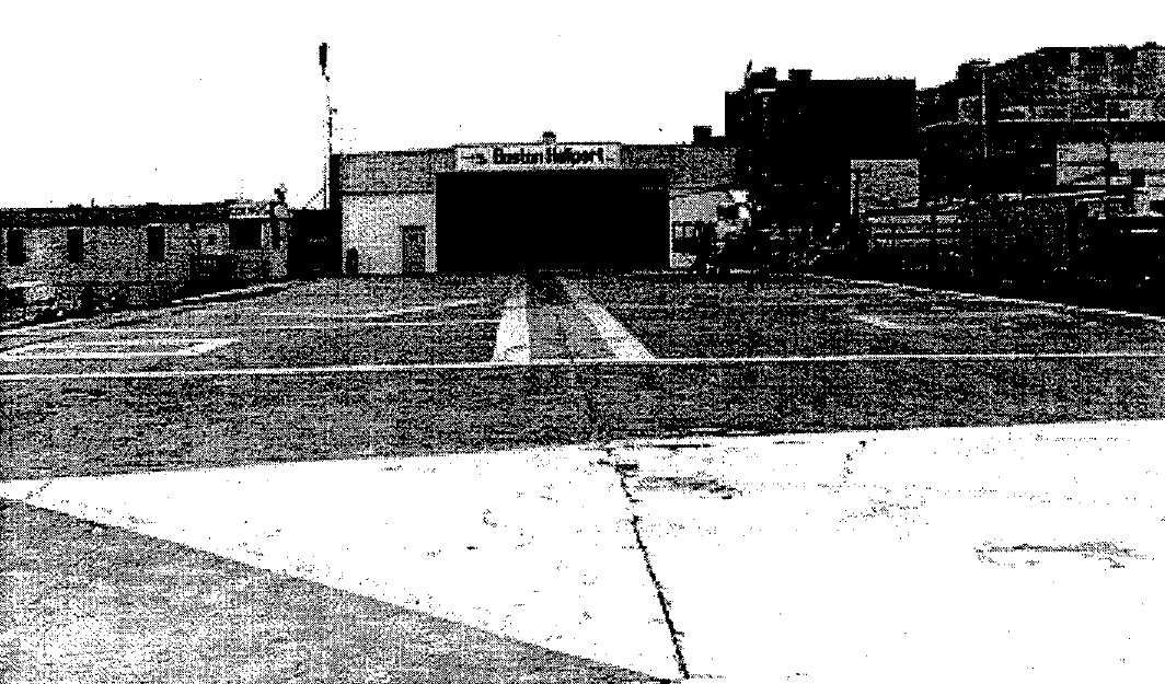
An undated photo of a hangar marked “Boston Heliport”, from the 1997 FAA report “Six Heliport Case Studies” (courtesy of Jonathan Westerling).
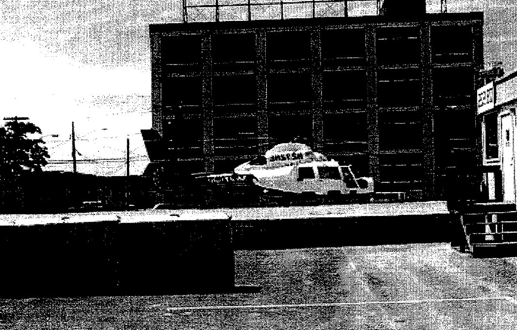
An undated photo of an Aerospatiale Dauphin parked at the Boston City Heliport, from the 1997 FAA report “Six Heliport Case Studies” (courtesy of Jonathan Westerling).
The 1997 FAA report “Six Heliport Case Studies” (courtesy of Jonathan Westerling) described the Boston Heliport:
"The TLOF & FATO of the Boston City Heliport are built on the original concrete floor of a former warehouse that is approximately 4' above ground level.
The surface shows signs of aging & weathering & appears to be in need of repair.
The area is 70' x 160'. The designated TLOF & 6 tie-down / parking positions can accommodate up to 6 SikorskyS-76-sized aircraft simultaneously.
If needed, there is space for an additional 12 helicopters in an adjacent 45,000 square-foot ground-level vehicular parking lot.
There is also a 6,000 square-foot maintenance & storage hangar that can accommodate 2-4 small or medium-size helicopters.
A converted mobile home is used as a terminal building. It has a waiting room, rest rooms, pilot flight planning room, and administrative offices.
There is lighting for night operations. Jet-A fuel is available from an underground storage tank & is dispensed via a pump & hose."
Shortly before its closure, the 1999 AOPA Airports USA directory listed the Boston Heliport as having a larger 210' x 70' landing pad.
A February 2006 Rotor & Wing magazine article summed up the fall of the Boston City Heliport accurately:
"The city decided to use the Boston City Heliport's land for a new convention center.
Operators & support groups fought in vain to have a heliport included in the city's plan.
Even in a city with no noise complaints, city planners are adopting the view that the public doesn't consider heliports the best use of land.
Unfortunately, this seems to be happening more & more.”
The Boston Heliport was closed by the end of 1999.
No public heliports were depicted in downtown Boston on the 2000 Boston Helicopter Route Chart.
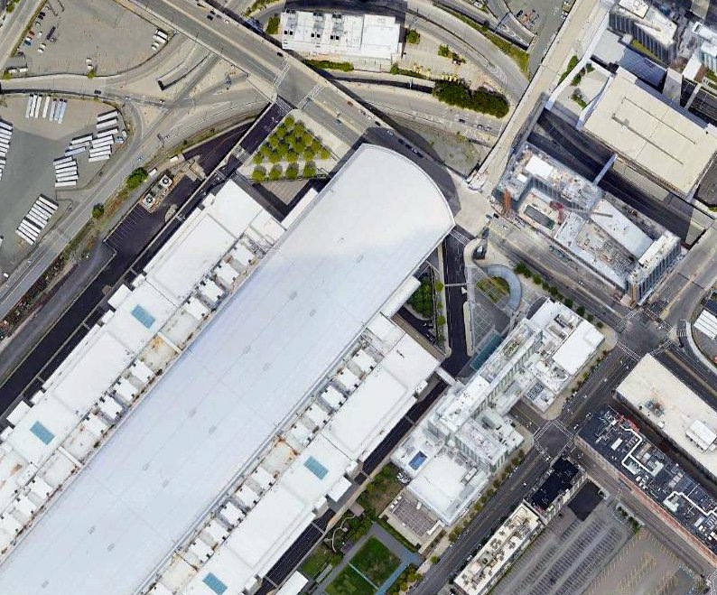
A 2020 aerial view depicted the Boston Convention Center covering the site of the Boston City Heliport.
Thanks to Jonathan Westerling for pointing out this heliport.
___________________________________________________
42.25, -70.92 (Southeast of Boston, MA)
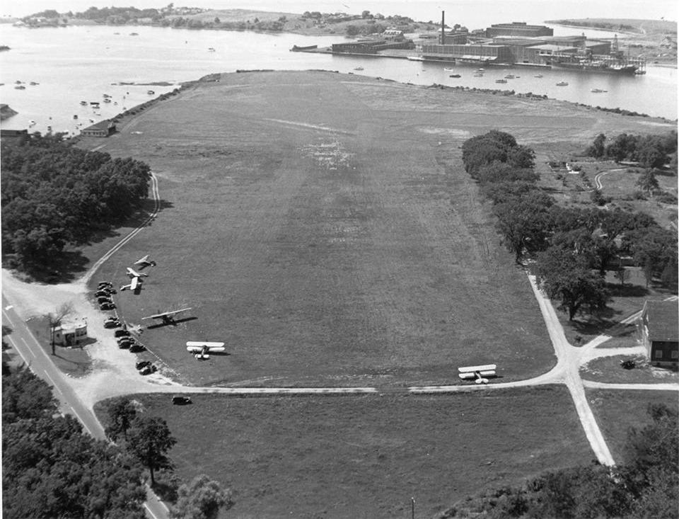
A 1938 aerial view looking north at Bayside Airport (courtesy of Roger Pinel).
This small airport on the shore of Hingham Bay, southeast of Boston, was evidently established at some point between 1935-38,
as it was not yet depicted on the August 1935 Boston Sectional Chart.
Bayside Airport was built by Peter Bradley to serve his enterprises, including his fertilizer plant directly across the water in Weymouth.
The earliest dated photo which has been located of Bayside Airport was a 1938 aerial view,
showing 6 single-engine planes & a small office around a grass airfield.
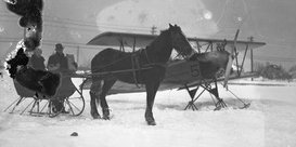
A circa 1930s photo (from the John P. Richardson Collection, Hingham Historical Society & Town of Hingham) of a ski-equipped Fleet biplane behind a horse-drawn sleigh at a snowy Bayside Airport.
According to Roger Pinel, “I worked for many years with a gentleman (Jack Phillipps) who told me he had done flight instruction for Bayside Flying Service at the airport.”
The only aeronautical chart depiction which has been located of Bayside Airport was on the September 1938 Boston Sectional Chart,
which depicted Bayside as a commercial/municipal airport.
No depictions have been located of Bayside Airport on USGS topo maps.
Unfortunately Bayside Airport had an extremely short lifespan.
It was evidently closed at some point between 1938-41,
as it was no longer depicted on the May 1941 Boston Sectional Chart.
Within weeks of the attack on Pearl Harbor, a survey team arrived in Hingham
and crews worked around the clock to clear 150 acres of land (including the Bayside Airport property) for a new shipyard,
urgently needed to mass-produce destroyer escorts for WW2.
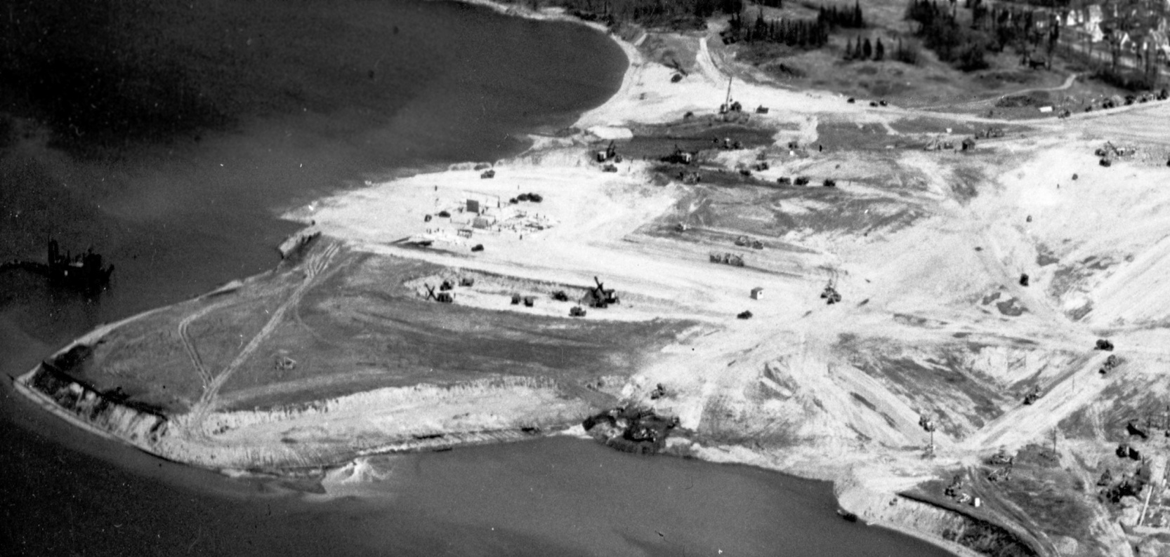
with the lace traces of the airport possibly visible at left, with the site being covered by construction of Bethlehem Hingham Shipbuilding.
During the 3.5 years that the yard was operational, Bethlehem Hingham Shipbuilding produced 277 ships, ending operations in 1945.
According to Roger Pinel, “The shipyard was idle for years after the war & the only thriving business from the 1960s on was a marina.”
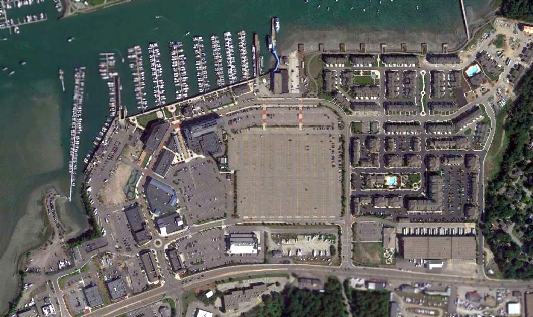
An 8/24/13 aerial view showed no trace remaining of Bayside Airport.
Roger Pinel reported in 2014, “In the past 5 years the buildings were demolished & a shopping center was built
and the marina upgraded & several thousand apartments have been erected.
There are no traces of the airport remaining.”
The site of Bayside Airport is located north of the intersection of Shipyard Drive & Essington Drive.
Thanks to Roger Pinel for pointing out this airfield.
___________________________________________________
Braintree Airport, Braintree, MA
42.205, -71.04 (Southeast of Boston, MA)
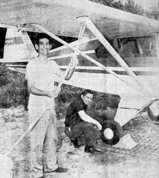
A 1952 photo of Malcolm Woronoff & Arnold Stymest (Braintree Airport's first manager) standing underneath a Piper TriPacer at Braintree Airport.
According to 9/20/11 article by Joseph Markman in BraintreePatch.com entitled “Expansion & Dangerous Flights Proved too Much for Old Airport”,
Braintree Airport, “in the western part of town near Great Pond”, was “created shortly after World War II by a group of young aviators.
Victor Heurlin graduated from high school toward the end of WWII,
avoiding most of that conflict's fighting but learning to fly in pilot school & going on to serve in the Air National Guard.
He & about a dozen young aviation enthusiasts formed the Braintree Airport Association in May of 1948
and found a manageable spot for a 1,200' runway – a heavily-wooded swamp near Great Pond in Braintree, on land owned by the Water Commission.”
They took 2 years to complete the runway, according to an account in the 1961 Town Report:
"Money was scarce but youth & hard labor soon developed a flying field that allowed them to land their planes safely."
The article continued, “Along with private fundraising, an appropriation of $1,000 soon allowed the runway to grow to 1,500',
and over the next several years more money came in for expansion,
making the runway longer & wider & attracting more than 100 South Shore residents to the association.
The location was said by the state's Civil Aeronautics Association to be one of the best on the South Shore,
according to a survey of the Boston area made just before the airport was built.”
Braintree Airport was not yet depicted at all on the July 1946 Boston Sectional Chart (or subsequent Sectionals through May 1959).
The earliest photo which has been located of Braintree Airport
was a 1952 photo of Malcolm Woronoff & Arnold Stymest (the first manager of Braintree Airport) standing underneath a Piper TriPacer.
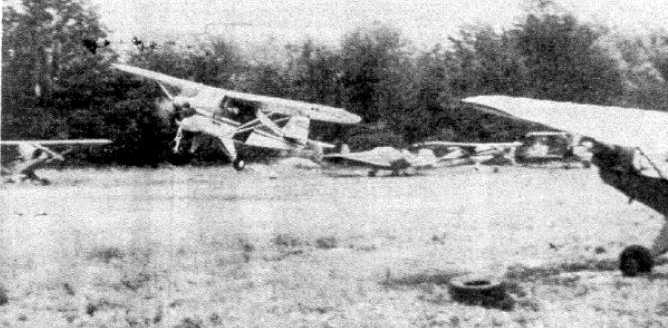
A 1952 photo of a Piper TriPacer taking off from Braintree (courtesy of Ed Francis), with several other single-engine aircraft parked on the field.
A circa 1952 photo of a large number of general aviation aircraft at Braintree Airport (courtesy of Ed Francis), including a surplus AT-6 Texan.
Braintree Airport was not yet depicted at all on the 1954 USGS topo map.
A 4/27/57 USGS aerial photo (courtesy of Ed Francis) depicted Braintree Airport as having an unpaved southeast/northwest runway.
There were no buildings evident at the airfield, but note the 3 single-engine aircraft parked on the west side.
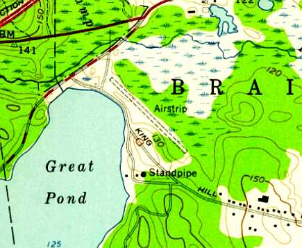
The 1958 USGS topo map (courtesy of Ed Francis) depicted Braintree Airport as an unpaved southeast/northwest runway, labeled simply as “Airstrip”.
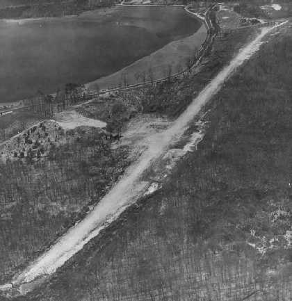
An undated aerial view of Braintree Airport, showing a single unpaved runway.
There were no aircraft visible, so the picture may have been taken after the airport's closure.
Braintree Airport was not depicted on the May 1959 Boston Sectional Chart (courtesy of Ron Plante).
According to 9/20/11 article by Joseph Markman in BraintreePatch.com entitled “Expansion & Dangerous Flights Proved too Much for Old Airport”,
“In 1959, a new group of aviators set out to revive the association,
clearing trees at the west end of the site & lengthening the runway another 200'.
Unknown to them at the time, soon the airport would face a series of difficulties, ultimately leading to its demise.”
The earliest aeronautical chart depiction which has been located of Braintree Airport was on the November 1959 Boston Sectional Chart.
It depicted Braintree as a private airfield with a 2,800' unpaved runway.
According to 9/20/11 article by Joseph Markman in BraintreePatch.com entitled “Expansion & Dangerous Flights Proved too Much for Old Airport”,
“Throughout the 1960s, the Braintree Airport Commission fought to retain the airport
despite a need for increased water storage right where the facility was.
And so the commission promoted its benefits to residents, using a familiar pro-development argument.”
Local Civil Defense officials also weighed in,
saying that the airport was "an important part of their plan of communication in times of emergency", the commission wrote in 1964.
During the 1950s & 1960s, Braintree was one of few communities in the area with an airport used by Civil Defense officials
as a staging point for nuclear radiation monitoring, using geiger counters from the air, according to an article in the Ledger, "Flying Time," by E.S. Locke.
Members of the public could also sign up for pilot lessons at the airport and even receive radiological monitoring training.
According to 9/20/11 article by Joseph Markman in BraintreePatch.com entitled “Expansion and Dangerous Flights Proved too Much for Old Airport”,
“But by 12/1/64, the airport was closed by order of the Braintree Water Commission.
Nearby the closed site, airport supporters found a 15-acre strip of land, also owned by the town,
to the southwest of King Hill Road & northwest of Old Route 128.”
"If the town sees fit to lease or part with the property,
the association members are prepared to give up their spare time
and get down to the back-breaking task of constructing a new 3,000' runway 100' wide," Ledger reporter Larry Masidlover wrote.
According to 9/20/11 article by Joseph Markman in BraintreePatch.com entitled “Expansion and Dangerous Flights Proved too Much for Old Airport”,
“Town reports & other archives leave a gap in the timeline here.
At some point between the 1964 closing of the airport and when it came back into the news with resident petitions & the Milton man's crash,
the new airport was constructed & the low-flying antics of some of the pilots began to draw increasing scorn from Braintree residents.”
David Keith recalled, “I took my ground school at the old Braintree Airport in 1966, given by Ground Instructor Arnie Stymest.
One of my classmates was John Walsh, then a well-known naturalist who starred in 'Walsh’s Animals', broadcast on WGBH Channel 2, Boston.
If anyone knows how I might reach John, I want to catch up with John, whom I haven’t seen for almost 50 years!”
Nearly 250 signatures filled a petition submitted in July of 1968 to the Board of Selectmen,
asking them "not to renew the airport license due to the hazards & dangers to the lives & property of residents in the vicinity."
According to 9/20/11 article by Joseph Markman in BraintreePatch.com entitled “Expansion and Dangerous Flights Proved too Much for Old Airport”,
“Braintree residents also cited noise as a concern, and mentioned an incident where a motorist was driven off the road because of a low-flying aircraft.
The selectmen appeared inclined to agree, but left it to the Airport Commission to draft a report on the issue.
Mr. & Mrs. Arthur Sarney, according to a Ledger article from the summer of 1968, spoke out at a selectmen meeting.”
Their house was closest to the airport and they said they couldn't host cookouts because of the airplanes,
adding that the air traffic pattern was usually "over our chimney."
The last aeronautical chart depiction which has been located of Braintree Airport was on the 1964 Boston Sectional Chart.
Braintree Airport was no longer depicted on the March 1965 Boston Sectional Chart.
The article continued, “Early president of the Braintree Airport Association & co-founder Victor Heurlin was long gone by this time, Connors said.
But Connors remembers that conflicted time in the late 1960s, recalling the concerns but also noting that she did not live under the flight path.”
"People were afraid of the planes," Connors said. "It never bothered me any."
The article continued, “The drive to close the airport ramped up in August of 1968
when Wilfred Bleakely, who lived on Otis Street in Milton, died after crashing his single-engine plane into the trees lining Pond Road.
Selectmen rushed the issue onto their September agenda,
even as the Airport Commission sought to renew the facility's license, which in July had received a postponement awaiting further study.
Before the Airport Commission could file its report, the Water Commission terminated the airport's lease,
and called for the removal of all planes & other equipment.
The commission cited the deadly crash, as well as the petition.”
The article continued, “All that remained was for Town Meeting to decide the fate of the Airport Commission,
which remained in limbo after the closure of the facility.
Members prepared a report for Town Meeting in March of 1969, exploring options –
for a new airport, a runway just for emergencies, even a heliport at the South Shore Plaza.”
"I think the town could be accused of short-sightedness if we did not delve into the case for an airport,"
the Ledger quoted commission member Silvio Ferrante as saying.
"Looking ahead to the 1980s, the town could be missing a bet in not planning carefully now."
The article continued, “There were understandable, even heavy, concerns
that led more than 200 Braintree residents to sign a petition to close the town's airport in 1968.
These concerns, along with the need for more water space in town, eventually did lead to the closure of the Braintree Airport.
For some, like Carol Heurlin-Connors, whose late half-brother Victor was among the Braintree Airport Association's founders, the memories are fond.”
”I remember soaring up in the clouds & looking down at the earth below because there was space in the floorboards," Connors said in a recent interview.
She was not afraid of the space at the bottom of Heurlin's plane, Connors said, because it was a different, more care-free time,
and her half-brother was a skilled pilot, who later went on to a career in flying business executives around the country.
A 1969 aerial view showed a road had been cut over the center of the Braintree runway, which otherwise remained intact.
There were no aircraft or any other sign of recent aviation usage.
The 1972 USGS topo map no longer depicted anything at the site of Braintree Airport.
Steve Clang recalled, “I remember the airfield was still there when I played hockey at Ridge Arena, which was just North of the airport.
As a kid in the early 1970s, I wished they had never closed the place.”
A 1978 aerial photo showed the Braintree runway remained intact, though deteriorated.
A 2008 aerial view still showed the faintest trace of the orientation of the Braintree runway, though heavily overgrown.
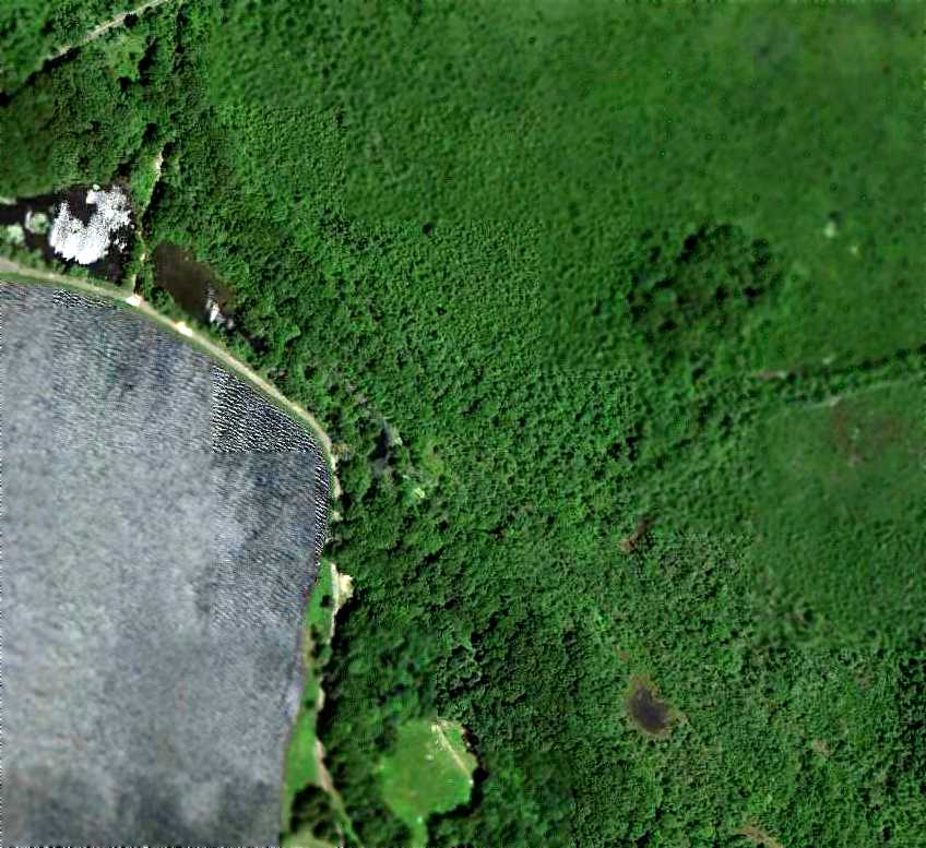
A 6/18/10 aerial view showed no trace remaining of Braintree Airport.
The site of Braintree Airport is located east of the intersection of King Hill Road & West Street.
___________________________________________________
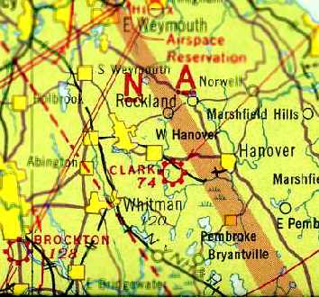
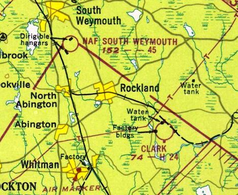
42.104, -70.866 (Southeast of Boston, MA)
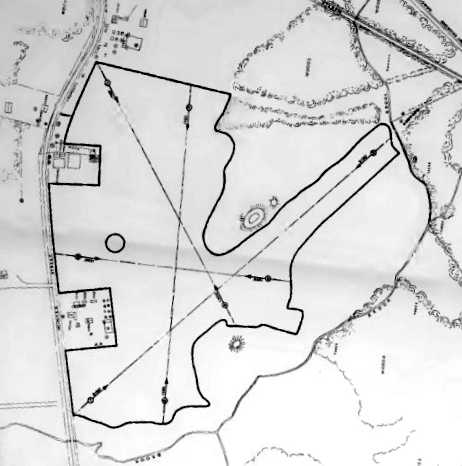
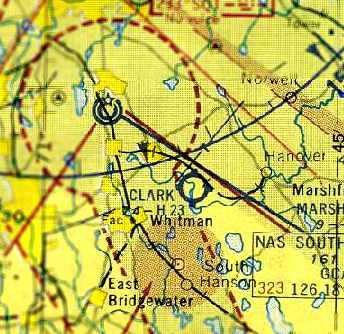
Clark Airport, as depicted on the March 1933 Boston Sectional Chart.
In 1927, William Clark started Clark Airport across Winter Street from his father's fireworks factory.
Clark Airport may have operated in an unofficial capacity for its first few years,
as it was not depicted among active airports on the Rand-McNally 1929 Air Trails Map (according to Chris Kennedy),
nor listed in the Airport Directory Company's 1933 Airport Directory (according to Chris Kennedy).
The earliest depiction which has been located of Clark Airport was on the March 1933 Boston Sectional Chart.
It depicted Clark as a commercial/municipal airport.
According to the MA Aeronautical Historical Society, as of 1935 Clark Airport was a commercial airfield located 2 miles West of town center.
It was a T-shaped field, having 4 sod runways, the longest measuring 2,100’ northeast/southwest.
A hangar was marked with “CLARK FIELD”.
Clark Airport was not listed in the Airport Directory Company's 1937 Airport Directory (courtesy of Bob Rambo).
The 1937 “Progress Report of the Committee For Aeronautics of the Commonwealth of MA” (courtesy of Jonathan Westerling)
depicted Clark Airport as an irregularly-shaped 50 acre sod field,
within which were a total of 4 landing directions, the longest being 2,100' northeast/southwest.
It was described as a commercial airport, owned by W.M. Clark of the National Fireworks Company,
and operated by East Coast Airways (F.J. Bedell).
Three hangars & an office building were depicted on the west side of the field.
By the late 1930s Clark was reportedly a bustling airport.
The Hanover Postmaster used the airport to deliver & pick up mail.
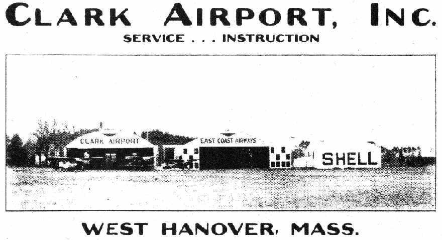
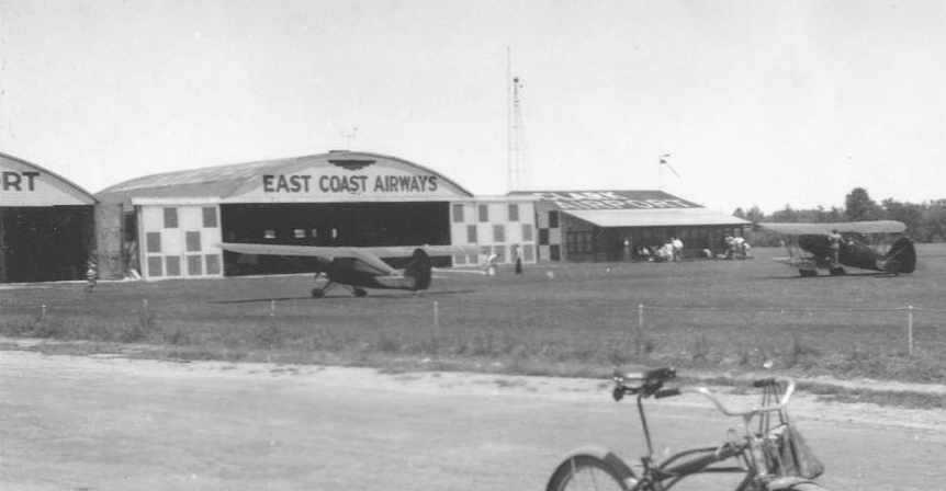
A circa 1930s advertisement for Clark Airport (courtesy of Andrew Stella),
showing several monoplanes in front of 2 hangars, labeled “East Coast Airways”.
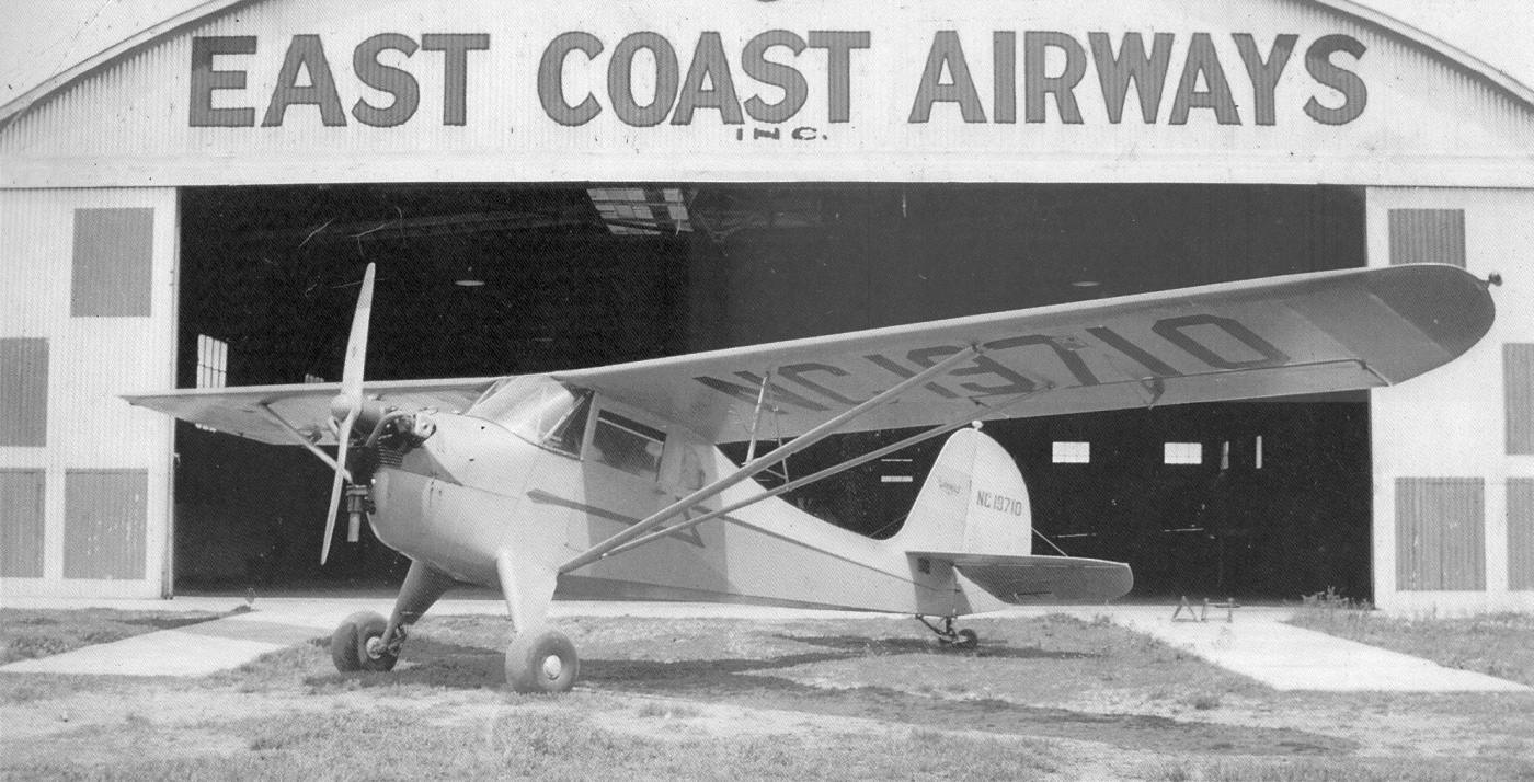
A circa 1938 or later photo of an Aeronca K in front of Clark Airport's East Coast Airways hangar (from the MA Aviation Historical Society's 2015 Calendar, courtesy of Bill Deane).
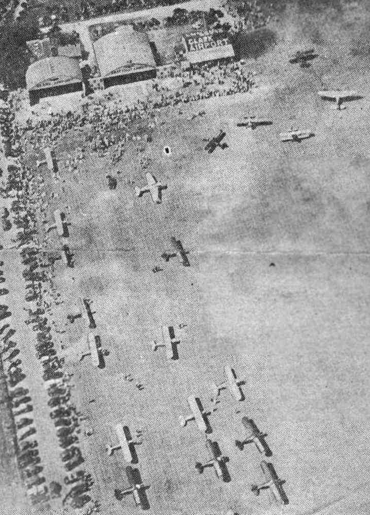
A 6/25/40 aerial view looking north at planes at the hangars at Clark Airport by Wendell Levings (courtesy of Andrew Stella).
The photo was taken during an air meet sponsored by the Bayside Sportman Pilots' Club & East Coast Airways Inc.,
and it was attended by a crowd of 20,000 spectators.
A June 1940 aerial view looking north at Clark Airport (from the MA Aeronautics Commission),
presumably taken during the same air meet sponsored by the Bayside Sportman Pilots' Club & East Coast Airways Inc.
An undated photo of planes & hangars at Clark Airport (courtesy of Andrew Stella).
The earliest topo map depiction which has been located of Clark Airport was on the 1940 USGS topo map.
It depicted Clark Airport as an open area (without depicting any runways),
but it did depict 4 small hangars along the northwest side of the field.
The May 1941 Boston Sectional Chart (courtesy of Chris Kennedy) depicted Clark as a commercial/municipal airport.
After the bombing of Pearl Harbor on 12/7/41, George Clark, the owner of the National Fireworks Company,
bought the airport land from his son William.
He needed the space to store supplies for making munitions & the airport was a great space for it.
The Plymouth County Registry of Deeds has records showing the National Fireworks Company
as having purchased a good amount of land on 12/30/41.
Clark Airport was not depicted at all on the November 1942 Boston Sectional Chart (according to Chris Kennedy)
nor the December 1945 Boston Sectional Chart (according to Chris Kennedy).
After the war was over George sold the land back to his son & the airport was once again back in operation.
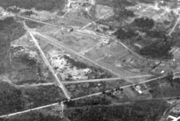
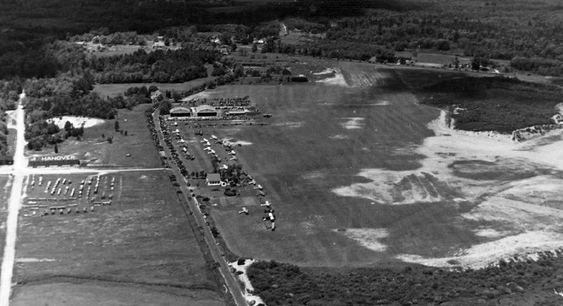
A circa 1940s aerial view looking west at Clark Airport (courtesy of Andrew Stella), showing 3 paved runways & a few hangars.
The 1949 USGS topo map depicted Clark Airport as having 3 paved runways,
with 3 small buildings along the northwest side of the field.
The 1949 Boston Local Aeronautical Chart (courtesy of Tim Zukas)
depicted Clark Airport as having a 2,400' paved runway.
The runways at Clark Airport were said to measure 3,000', 2,500', and 1,650'.
The field also had 4 hangars, including a repair shop.
Clark Airport was depicted on the November 1954 Boston Sectional Chart (according to Chris Kennedy).
The last aeronautical chart depiction which has been located of Clark Airport
was on the November 1955 Boston Sectional Chart (courtesy of Chris Kennedy).
It depicted Clark as having a 2,300' paved runway.
In 1958 William Melvin Clark sold the land to the Indian Head Land Trust, who began to develop it as a residential area.
A circa 1958 aerial view looking southwest at the site of Clark Airport
(from the 1997 Hanover Historical Society Calendar, courtesy of Andrew Stella).
By this time the airport property was in the process of being redeveloped.
No traces of the field remained recognizable in a 1960 aerial photo – the site was covered in houses.
Clark Airport was no longer depicted at all on the March 1963 Boston Sectional Chart (according to Chris Kennedy).
Bill Deane reported in 2013, “The site was, and is now, a major environmental hazard site
for the town of Hanover & the Commonwealth of Massachusetts to deal with.
Clark Airport itself was not the polluter.
The National Fireworks Company Company, that owned the airport,
and manufactured fireworks & military munitions near the airport was polluting the site from 1907-1970.”
A 2016 aerial view looking north showed not a trace appeared to remain of Clark Airport, with houses covering the property.
David Gray reported in 2017, “The old site of National Fireworks Factory in Hanover has a Temporary Flight Restriction over it from ground to 2,000' MSL.
This is also the Clark Airport that stored & manufactured munitions during WW2.
It is nearly all developed now, but during recent excavations some type of unused ordinance was unearthed, prompting a large scale cleanup, hence the TFR.”
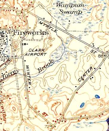
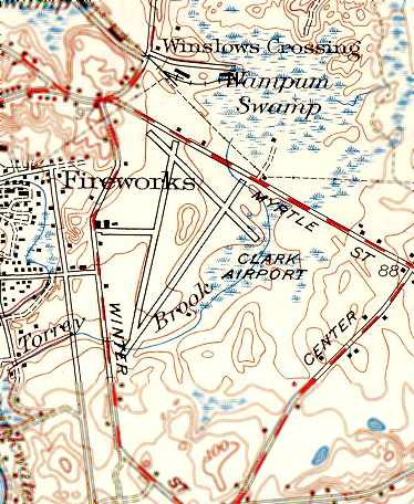
The site of Clark Airport is located southeast of the intersection of Winter Street & Myrtle Street.
___________________________________________________
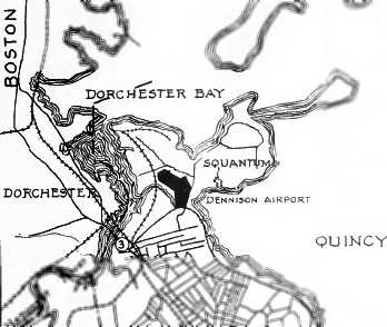
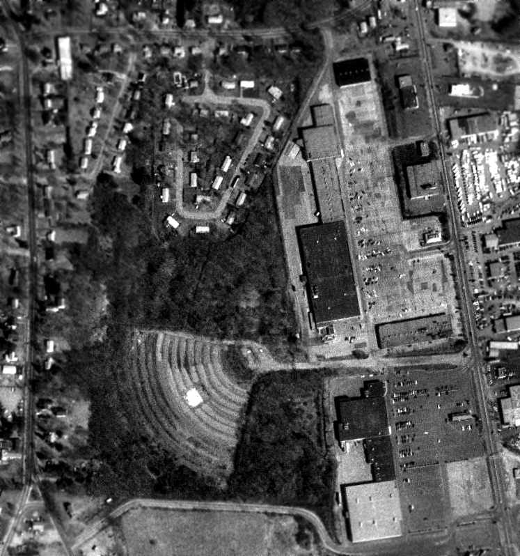
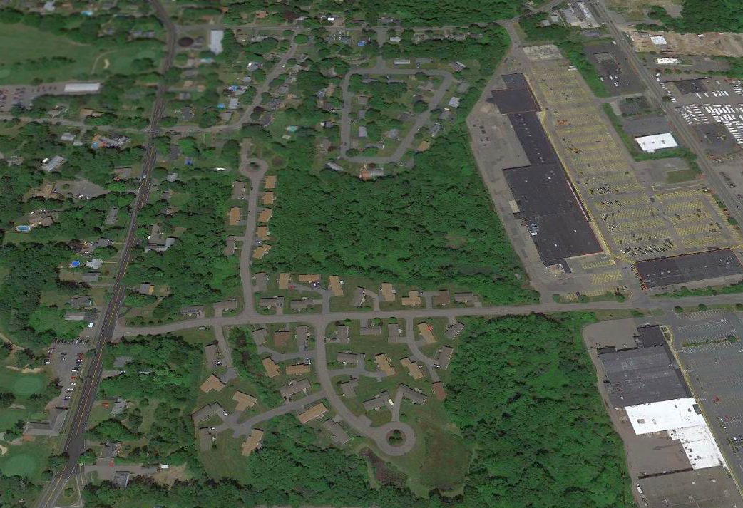
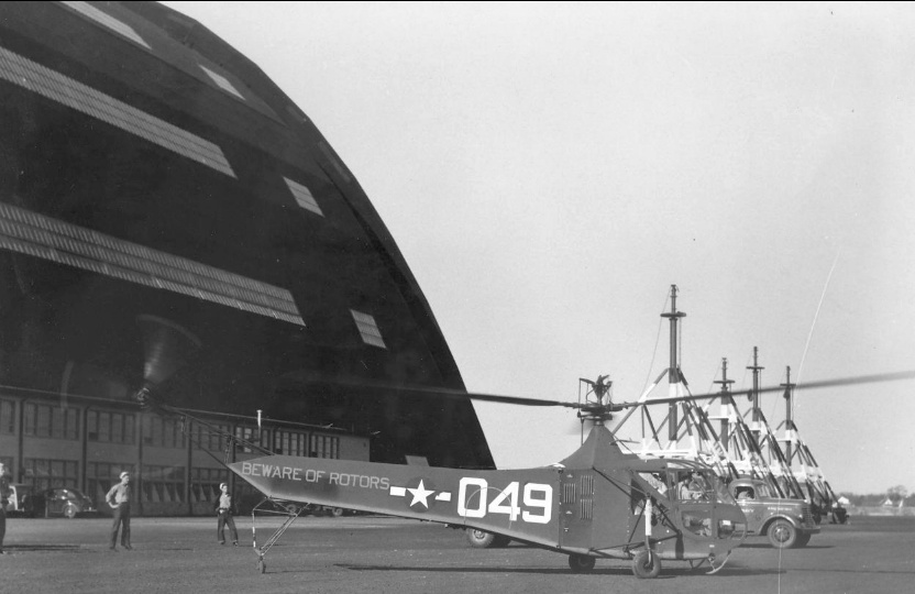
Harvard Aviation Field / Squantum Naval Air Station, Quincy, MA
42.295, -71.032 (South of Boston, MA)
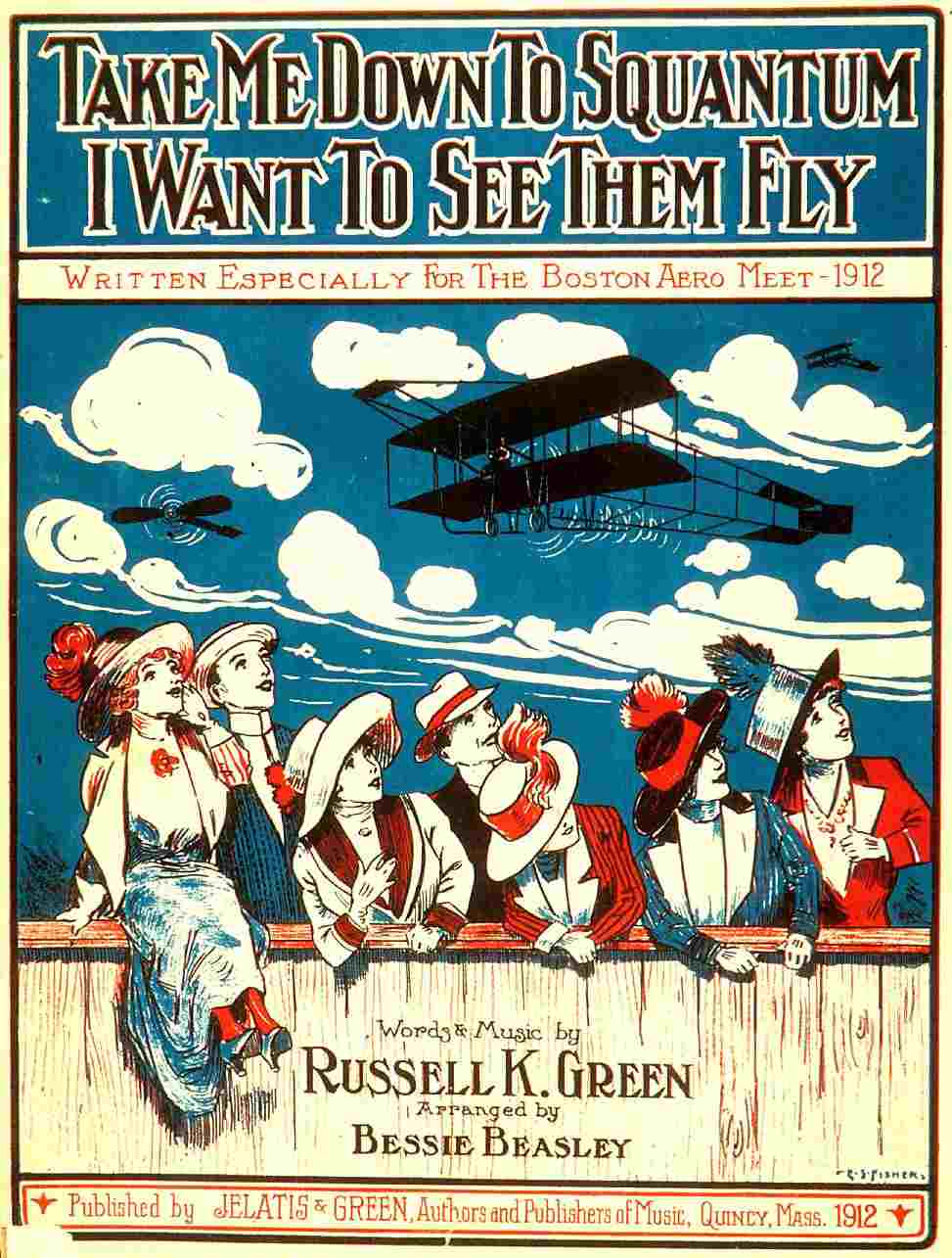
The cover of “Take me down to Squantum, I want to see them fly”, written for Boston's 1912 Aero Meet (courtesy of Rik Sheridan).
The origins of the Squantum airfield date back to 1910.
According to Bill Deane of the Massachusetts Aviation Historical Society,
in 1910 a plot of undeveloped land on the Squantum peninsula was leased by the Harvard Aeronautical Society from the NY & New Haven RR.
They used the property to hold the 1910 & 1911 Harvard Boston Aero Meets.
Squantum was the location of the first Intercollegiate Glider Meet in May 1911.
This event, the first of its kind in America, featured gliders that were built & flown
by students from a number of colleges around the country such as Harvard, MIT, Tufts, etc.
To work around the fact that Squantum has no hills from which to launch a glider,
the sponsors of the Intercollegiate Glider Meet erected a swiveling wooden ramp on the Harvard Aviation Field
to allow the participants to launch their craft into the wind regardless of its direction.
Squantum's 1912 Boston Aero Meet was marked by tragedy when aviatrix Harriet Quimby & her passenger William Willard
fell 1,000' to their deaths in the Neponset River from Quimby's Bleriot Monoplane in front of thousands of spectators.
After their lease expired in 1915, the field was rented out to individual aviation experimenters,
and in 1916 the field was leased to the Sturtevant Aeroplane Company for flight testing.
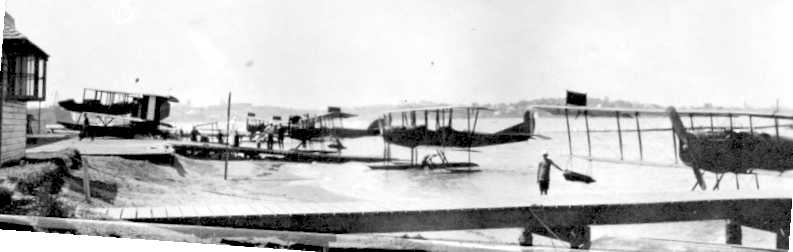
The earliest photo which has been located of NAS Squantum
was an early summer 1917 photo looking eastward across the Dorchester Bay shoreline,
showing several floatplanes, including a rare Burgess-Dunn BD & several N-9s.
During the spring of 1917, after the country entered the First World War,
the Massachusetts Naval Militia built a wooden seaplane hangar along the Dorchester Bay shoreline
and used the site as a primary flight training facility for student pilots bound for advanced flight training with the Navy at Pensacola, FL.
That summer, the Navy took over the Massachusetts Naval Militia property
and Squantum became a Naval Air Station providing primary flight training for student naval aviators as well as training for aircraft mechanics.
In the fall of 1917 NAS Squantum was closed due to the Navy's decision
to consolidate all flight training activity in warmer areas of the country where flying could be conducted year-round.
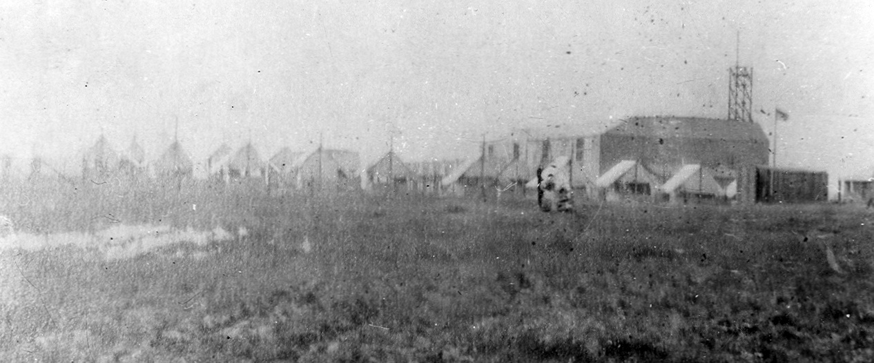
A 1917 photo of tents & hangars at Naval Air Station Squantum (from the National Museum of Naval Aviation).
The Bethlehem Steel Company built the Victory Plant Shipyard on the northern side of the Squantum property,
and built 35 destroyers between 1918-1920.
In 1923 the long-closed First World War Naval Air Station at Squantum was re-opened
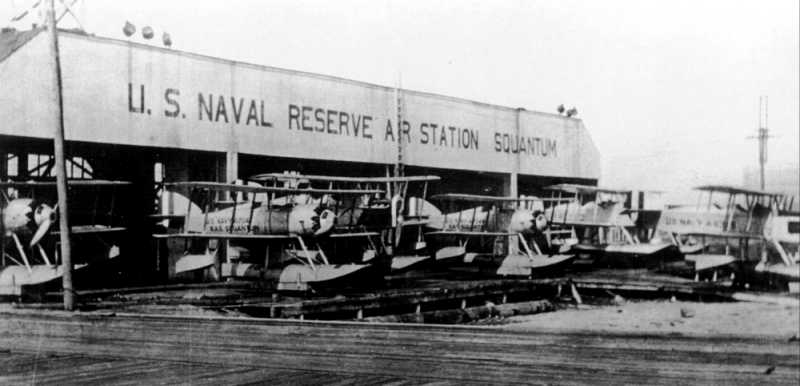
as a Naval Reserve Air Station providing refresher training to veterans as well as primary flight instruction to new members of the Naval Reserve.
Although initially a Navy Reserve facility, Squantum soon became used by the Marine Corps Reserve as well.
A 1926 view of Chance-Vought UO-1 & Burgess-Curtiss N-9H training floatplanes in front of the Naval Reserve Air Station Squantum hangar.
At first NRAS Squantum had no airfield & was only capable of operating seaplanes.
However, a small 30-acre airfield was built at the base in 1929, permitting operations with landplanes.
The earliest map depiction of the Squantum "Naval Reserve" Seaplane Base which has been located
was on the 1929 Rand-McNally Air Trails Map of Massachusetts (courtesy of Chris Kennedy).
An undated photo of a Bristol M1C monoplane (courtesy of Craig Westerman).
The original caption read, “Army flier on air jaunt.
Photo shows Lt. G.S. Haberle, beside the bullet-like monoplane he will fly on a transcontinental flight from Quincy MA to San Diego CA to join the aircraft carrier U.S.S. Lexington.
The plane, a British fighting-type model, was rebuilt at the Squantum Airport, from which he takes off November 1. 11-1-29.”
The Boston Chamber of Commerce's 1931 "Airports & Landing Fields of New England" (courtesy of Chris Kennedy)
described the Squantum U.S. Naval Reserve Aviation Base as consisting of a 30-acre triangular cinder field.
It was said to have 3 runways, with the longest being an 1,800' east/west strip,
along with a 120' x 120' landplane hangar & a 100' x 60' seaplane hangar.
The earliest aeronautical chart depiction of the Squantum Seaplane Base which has been located was on the 1933 Boston Sectional Chart.
The 1934 U.S. Navy Aviation Chart (courtesy of Chris Kennedy) depicted Squantum as having an airfield as well as a seaplane base.
A 1937 USN aerial view looking southwest (from the MA Digital Commonwealth, courtesy of Kevin Rutherford) at the Victory Plant shipyard buildings on the north side of NAS Squantum.
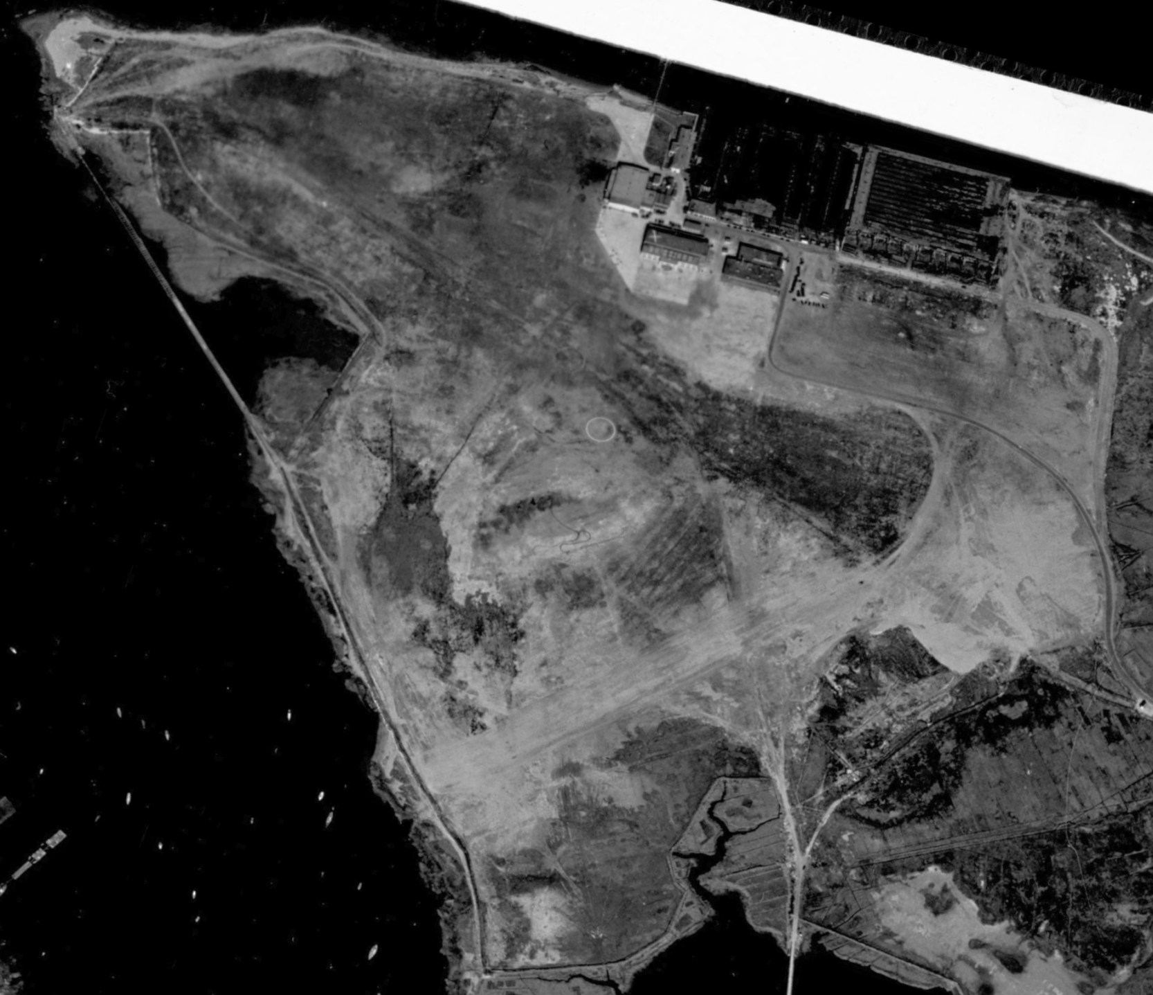
A 10/29/38 USN aerial view (from the MA Digital Commonwealth) showed NAS Squantum while it still had an unpaved airfield, with an airfield circle marking in the center.
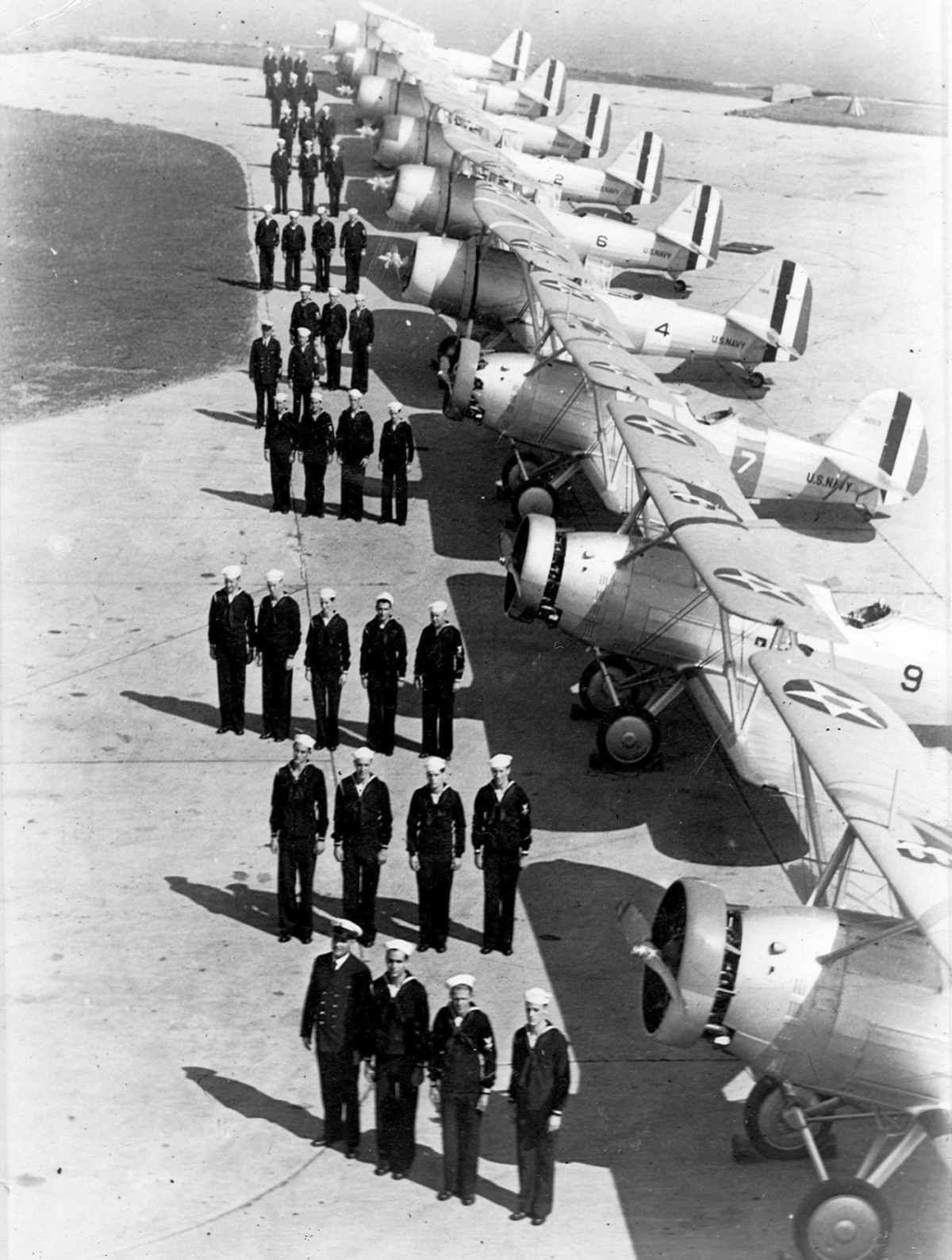
A 1938 U.S. Navy photo of personnel of reserve scouting squadron VS-2R lined up for inspection in front of Berliner-Joyce OJ-2 & Vought SBU aircraft (last 6, background) at NRAB Squantum.
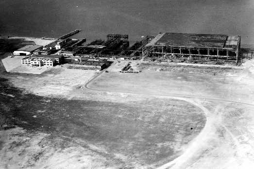
An October 1939 aerial view looking north at the Victory Plant shipyard buildings on the north side of NAS Squantum being removed.
In 1940, the Navy began improving the facility to handle larger planes & seaplanes.
The former Victory shipyard plant, gutted by a previous fire, was razed,
and hangars & new facilities were built on its site, including a large seaplane basin on the northern side of the peninsula.
These improvements resulted in Squantum being designated a fully-fledged regular Naval Air Station in 1941.
During the war, NAS Squantum provided Elimination & Primary flight training for Navy & Marine Corps student pilots,
advanced training for British Royal Navy torpedo & dive bomber squadrons & for US Navy carrier air groups,
and also served as an operational patrol base helping to protect the waters around Boston Harbor from the German submarine menace.
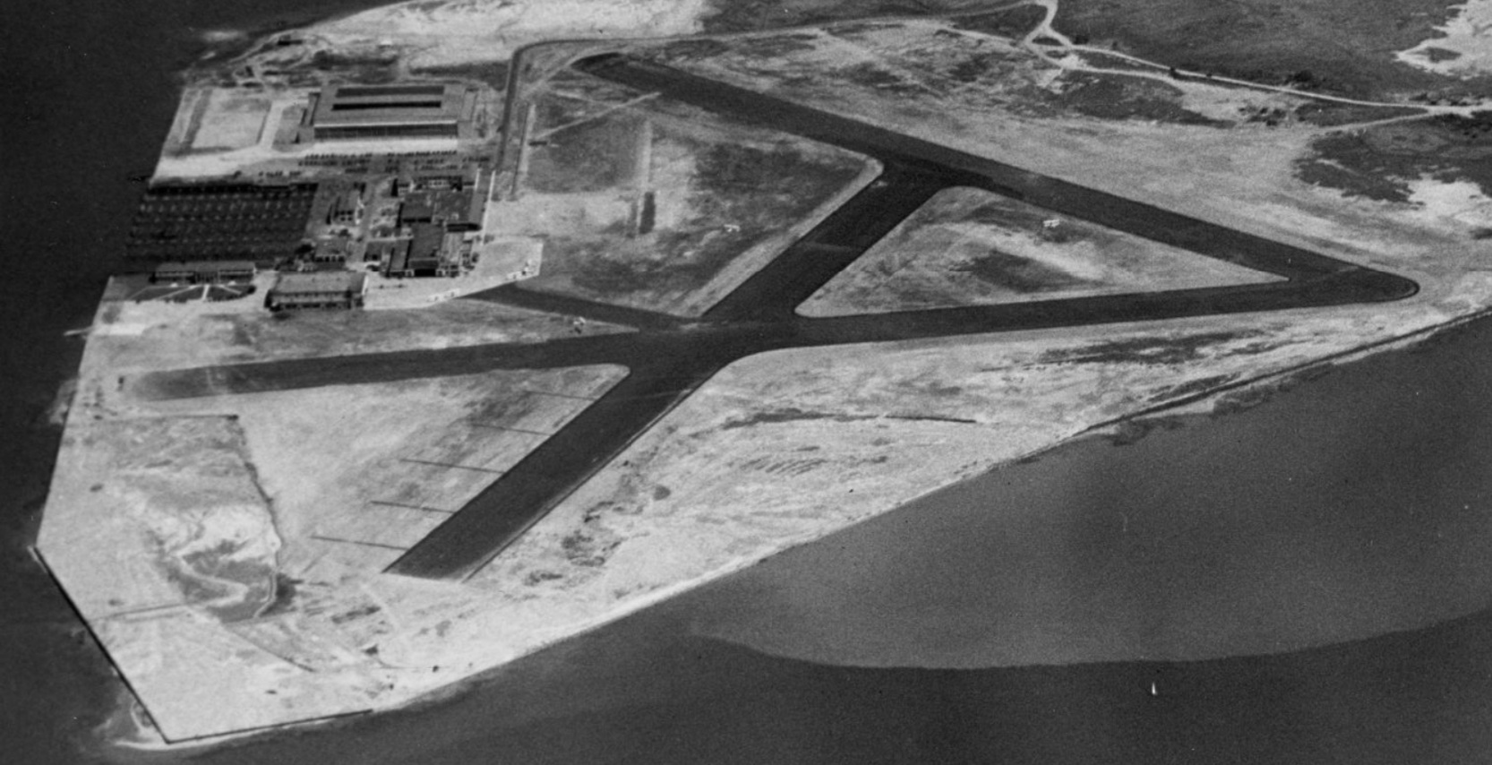
An 8/11/41 USN aerial view looking east (from the MA Digital Commonwealth, courtesy of Kevin Rutherford)
depicted NAS Squantum as having 3 asphalt runways, and a ramp & hangars on the north side.
An 8/11/41 USN aerial view looking north (from the MA Digital Commonwealth, courtesy of Kevin Rutherford)
depicted NAS Squantum as having 3 asphalt runways, and a ramp & hangars on the north side.
According to Bill Deane of the Massachusetts Aviation Historical Society,
the adjacent Dennison Airport to the south ceased operations in 1942
and its land was taken over by the Navy for the expansion of the Squantum facility.
Squantum became the home of a Special Project Unit in 1943,
which flight tested new equipment being developed at MIT.
NAS Squantum, as depicted on the 1943 USGS topo map.
According to the Royal Navy Research Archive, “Fleet Air Arm squadrons first arrived [at NAS Squantum] at the end of July 1943,
when #848 Avenger squadron arrived from NAS Brunswick, this was followed on August 24th by 849 squadron which relocated its Avengers from Quonset Point.
The station facilities were transferred to the Royal Navy on loan from 9/1/43 for use as a Torpedo, Bomber and Reconnaissance and Dive Bomber squadron formation & work-up station.
The station was commissioned as part of HMS SKAKER on September 1st, and 859 squadron became the first Avenger unit to form at Squantum.
All Avenger squadrons were equipped with 12 aircraft, initially these were all Mk.1s.
Work-up complete, 848 squadron flew out to embark in the CVE (escort aircraft carrier) HMS TRUMPETER on the 4th.
By October there were 3 new squadrons on the station at a time, the next to form was 851 on October 1st.
On November 1st 849 departed for NAS Norfolk to embark in CVE HMS KHEDIVE, their place being taken by 852 Qquadron which formed on the same day.”
List Fleet Air Arm units based at Squantum during WW2:
#848: Torpedo, Bomber and Reconnaissance Squadron, Moved here from NAS Brunswick 7/31/43. Equipped with 12 Avenger 1s.
#849: Torpedo, Bomber and Reconnaissance Squadron. Moved here from NAS Quonset Point 8/24/43. Equipped with 12 Avenger 1s.
#850: Torpedo, Bomber and Reconnaissance Squadron. Formed here 9/1/43. Equipped with 12 Avenger 1s.
#851: Torpedo, Bomber and Reconnaissance Squadron. Formed here 10/1/43. Equipped with 12 Avenger 1s.
#852: Torpedo, Bomber and Reconnaissance Squadron. Formed here 11/1/43. Equipped with 12 Avenger 1s.
#853:, Torpedo, Bomber and Reconnaissance Squadron. Formed here 12/1/43. Equipped with 12 Avenger IIs.
#854: Torpedo, Bomber and Reconnaissance Squadron. Formed here 1/1/44. Equipped with 12 Avenger IIs.
#855: Torpedo, Bomber and Reconnaissance Squadron. Formed here 2/1/44. Equipped with 12 Avenger IIs.
#856: Torpedo, Bomber and Reconnaissance Squadron. Formed here 3/1/44. Equipped with 12 Avenger IIs.
#857: Torpedo, Bomber and Reconnaissance Squadron. Formed here 4/1/44. Equipped with 12 Avenger IIs.
#1820: Dive Bomber Squadron. Moved here from NAS Brunswick 5/1/44. Equipped with 9 x Helldiver.
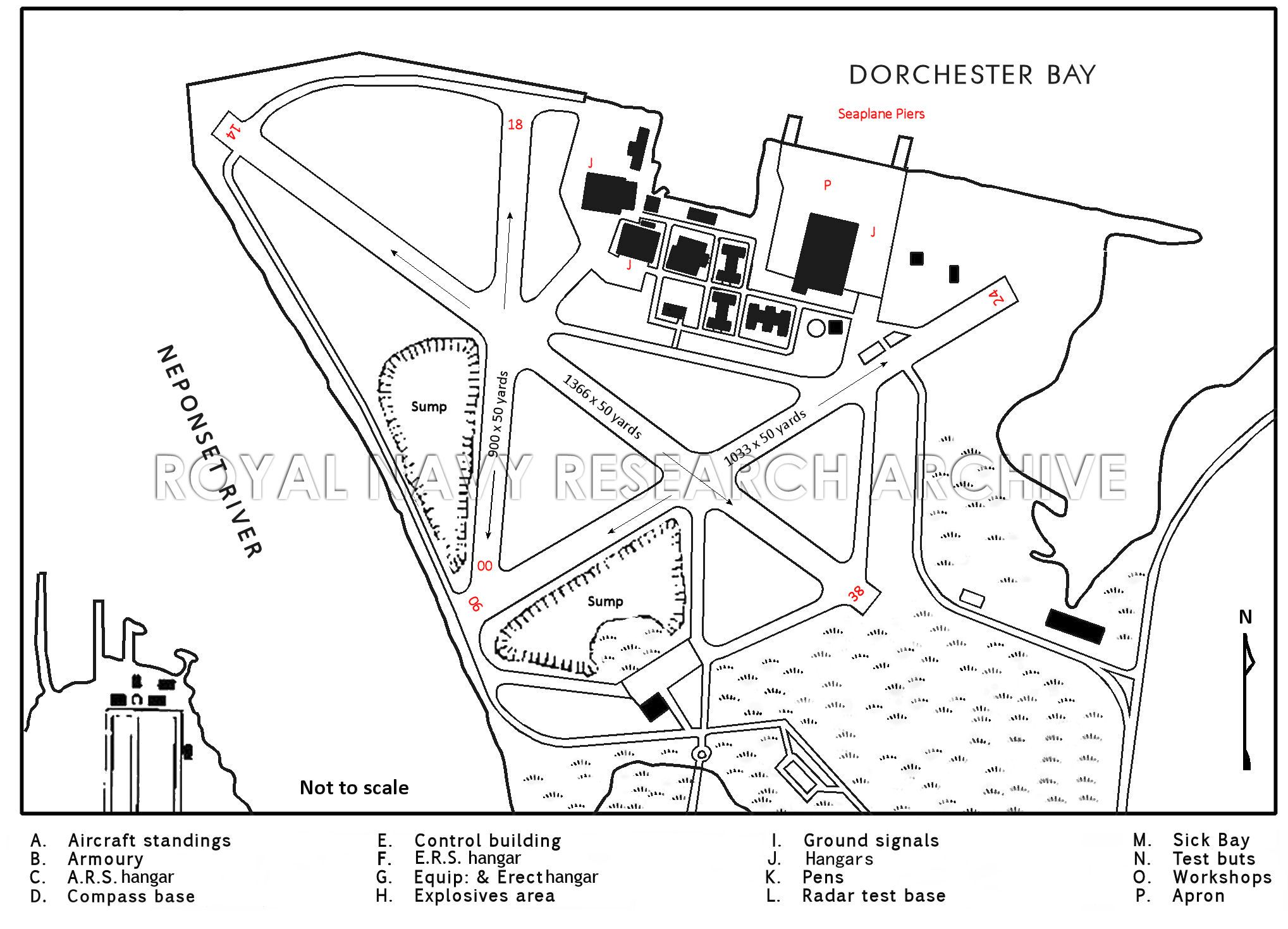
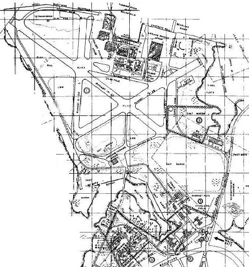
The layout of WW2 facilities of NAS Squantum (from the Royal Navy Research Archive).
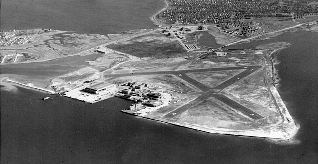
A March 1943 aerial view looking southeast showed NAS Squantum to have 3 asphalt runways.
During WW2 Squantum had auxiliary fields at Beverly & Ayer, and Outlying Fields at Norwood, Plymouth, and Mansfield.
A WW2-era aerial view looking north at NAS Squantum (National Archives photo).
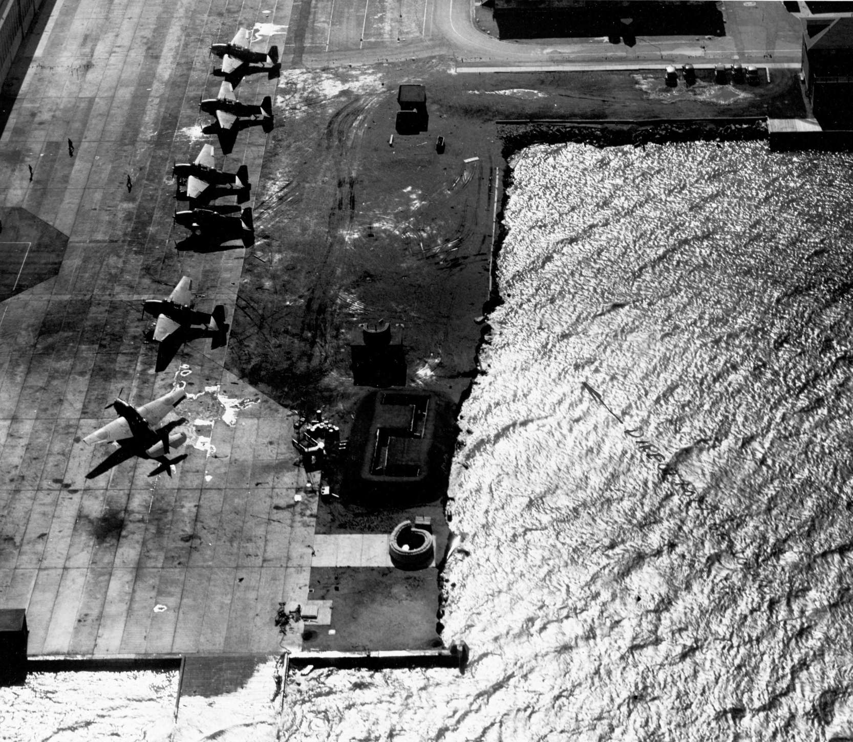
A 2/25/44 USN aerial view (from the MA Digital Commonwealth, courtesy of Kevin Rutherford) showing 6 Grumman TBF Avengers on the NAS Squantum ramp,
taken during high tide, showing the perilous situation of the waters only a few feet below the ramp.
A 2/25/44 USN aerial view (from the MA Digital Commonwealth, courtesy of Kevin Rutherford) of 6 Grumman TBF Avengers around the NAS Squantum hangar,
taken during high tide, showing the perilous situation of the waters only a few feet below the ramp.
According to the Royal Navy Research Archive, “The last [Fleet Air Arm unit] to leave was 1820 which moved to NAS Norfolk on 7/5/44 to embark in the CVE HMS ARBITER.
There is no record of any further use by the Fleet Air Arm & it is assumed the facility was returned to USN custody sometime in July 1944.”
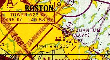
"Squantum (Navy)", as depicted on the November 1944 Boston Sectional Chart (courtesy of Chris Kennedy).
The 1944 USGS topo map labeled the property as “U.S. Naval Reservation”, but did not depict an airfield, strangely.
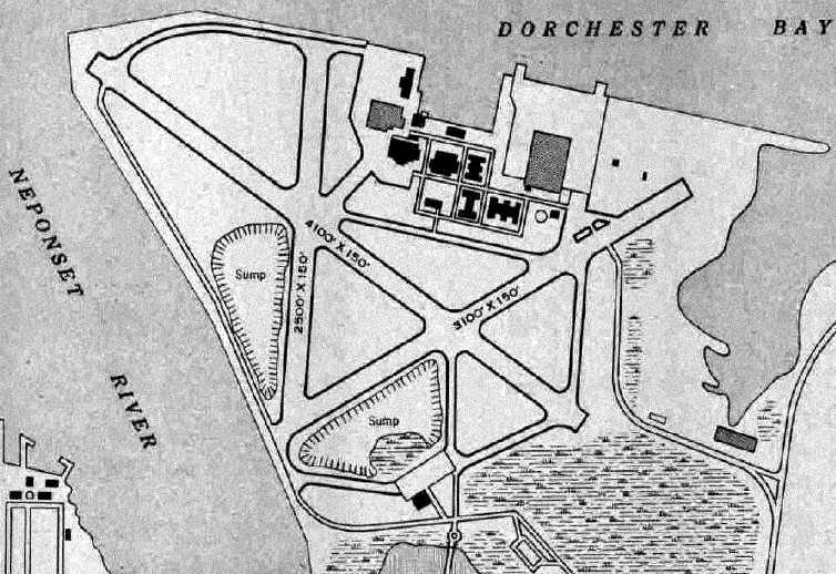
The 1945 AAF Airfield Directory (courtesy of Scott Murdock) described Squantum NAS as a 593 acre property,
within which were 3 bituminous runways, the longest being the 4,000' northwest/southeast strip.
The field was said to have 2 hangars, and to have 2 auxiliary fields: 22511 Norwood Municipal Airport to the southwest, and Mansfield Outlying Field, to the south-southwest.
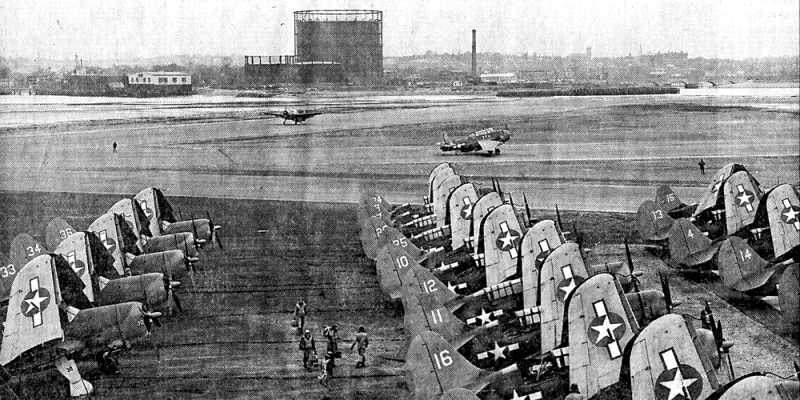
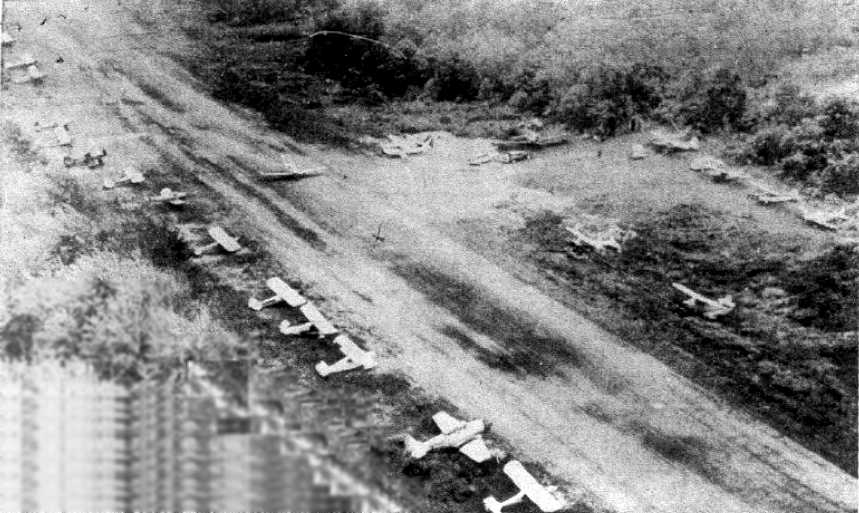
A 1945 photo of large numbers of Curtis SB2C Helldivers on Squantum's ramp, with 2 Eastern TBM Avengers on the taxiways.
Squadrons based at NAS Squantum:
VS-4 (Administratively assigned to Squantum but based in Boston), VF-11 (Administratively assigned to Squantum but based in Boston),
VN-1RD1 (Formerly VS-4), VN-2RD1 (Formerly VF-11), VF-6MR, SC-5MR, VO-1MR (Formerly VF-6MR), SS-5MR (Formerly SC-5MR),
VS-1R (Formerly VN-1RD1), VS-2R (Formerly VN-2RD1), VMS-1R (Formerly VO-1MR & SS-5MR combined),
VJ-4 (Detachment of squadron based at NAS Norfolk, VA), VS-1D1 (Inshore Patrol squadron established at NAS Squantum),
VR-1 (Detachment of squadron based at NAS Norfolk, VA), VS-31 (Formerly VS-1D1),
SPU Cast (Supported various electronic systems projects), 848 Squadron (Royal Navy Fleet Air Arm torpedo squadron),
849 Squadron (Royal Navy Fleet Air Arm torpedo squadron), 850 Squadron (Royal Navy Fleet Air Arm torpedo squadron),
851 Squadron (Royal Navy Fleet Air Arm torpedo squadron), 852 Squadron (Royal Navy Fleet Air Arm torpedo squadron),
853 Squadron (Royal Navy Fleet Air Arm torpedo squadron), 854 Squadron (Royal Navy Fleet Air Arm torpedo squadron),
855 Squadron (Royal Navy Fleet Air Arm torpedo squadron), 856 Squadron (Royal Navy Fleet Air Arm torpedo squadron),
857 Squadron (Royal Navy Fleet Air Arm torpedo squadron), SPU Dove (Supported Project Dove infra-red guided anti-shipping bomb),
820 Squadron (Royal Navy Fleet Air Arm dive-bomber squadron), CASU-22-5 (Detachment of CASU based at NAS Quonset Point, RI),
VF-45 (CAG-45), VT-45 (CAG-45), VF-48 (CAG-48), VT-48 (CAG-48), VT-89, VF-21 (CAG-21), VT-21 (CAG-21), VT-151, VF-39 (CAG-39),
VT-39 (CAG-39), VT-44, VF-29 (CAG-29), VT-29 (CAG-29), SPU Cadillac (Supported Project Cadillac AEW system),
VJ-15 (Detachment of squadron based at NAS Quonset Point, RI), VF-723 (CVG-723), VBF-723 (CVG-723), VB-723 (CVG-723),
VT-723 (CVG-723), VF-796 (CVEG-796), VT-796 (CVEG-796), VF-797 (CVEG-797), VT-797 (CVEG-797), VP-919,
VMF-217 (Marine Corps Reserve), CASU-713 (Reserve Carrier Aircraft Support Unit), VMF-235 (Marine Corps Reserve, activated for Korean War),
VF-77A (CVG-77, formerly VF-723), VF-78A (CVG-77, formerly VBF-723), VA-77A (CVG-77, formerly VB-723), VA-78A (CVG-77, formerly VT-723),
VF-56A (CVG-56, formerly VF-796), VA-56A (CVG-56, formerly VT-796), VF-57E (CVG-57, formerly VF-797), VA-57E (CVG-57, formerly VT-797),
VP-ML-69 (Formerly VP-919), VR-57, FASRON-71 (Reserve Fleet Aircraft Support Squadron, formerly CASU-713),
FASRON-171 (Reserve Fleet Aircraft Support Squadron, formerly CASU-713), VR-59,
MGCIS-21 (Marine Corps Reserve Ground Control Intercept unit), VF-58L (CVLG-58), VA-58L (CVLG-58),
AVUA-1 (Drilled at NAF Brunswick, ME), AVUA-2 (Drilled at New Bedford Airport in New Bedford, MA), AVUA-3 (Drilled at Barnes Airport in Westfield, MA),
AVUA-4 (Transferred from NAF South Weymouth to NAS Squantum), AVUA-5 (CIC unit drilling at NAS Squantum), AWS-91 (Air Wing Staff 91)
FASRON-911 (Formerly FASRON-71 and FASRON-171), VC-911 (Composite attack squadron), VC-912 (Composite anti-submarine warfare squadron),
VC-913 (Composite anti-submarine warfare squadron), VF-911, VF-912, VF-913, VF-914, VF-915, VF-916 (Activated for Korean War, became VF-83 then VFA-83),
VF-917, VP-911 (Formerly VP-ML-69), VR-911 (Formerly VR-57), VR-912 (Formerly VR-59), AVUA-6 (Drilled at NAS Squantum), ZP-911, VA-911 (Formerly VC-911),
VA-912, VA-913, VS-911, VS-912 (Formerly VC-912), VS-913 (Formerly VC-913, activated for Korean War, became VS-39), AAU-911 (Formerly AVUA-2),
AAU-912 (Formerly AVUA-3), AAU-913 (Formerly AVUA-4), AAU-914 (Formerly AVUA-5), AAU-915 (Formerly AVUA-6), AGU(L)-911 (Large auxiliary ground unit),
VMF-322 (Replacement for VMF-235), HU-911.
At the end of WW2, Squantum continued its flight training program, but at a reduced pace.
Due to its location on a peninsula, Squantum's short runways couldn't be lengthened to support operations of new generations of jet aircraft.
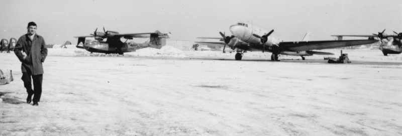
A March 1948 photo of 2 Consolidated PBY Catalinas & a Douglas R4D Skytrain on a snowy Squantum ramp.
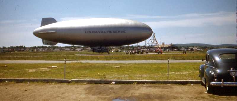
A circa 1950 photo of a US Naval Reserve blimp (model undetermined) attached to a mobile mooring tower at NAS Squantum.
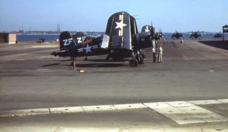
The last photo which has been located showing aircraft at NAS Squantum was a circa 1950 photo of a Chance-Vought F4U Corsairs along the ramp on the north side of the field.
Bob Wright recalled, “I enlisted in the Naval Air Reserve at Squantum Naval Air Station in 1952.
My first unit was ZP-911, the blimp squadron, and I moved with it to South Weymouth Naval Air Station.”
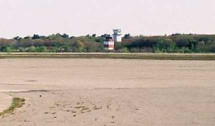
Robert Ervin recalled, “I started my 38 year career as an Air Traffic Controller in Squantum Tower in 1952.
Ed Brennen & I stood the last watch in the SQT tower sometime in November of 1953
and the next day we reopened NAS South Weymouth about 20 miles south of Squantum.
The Boston Logan Instrument Landing System was lined up almost perfectly with that SQT Runway 2.
That was another reason that this fine little 'country club' NAS was closed.
Too close to the big airport!”
According to Bill Deane of the Massachusetts Aviation Historical Society, “NAS Squantum squadrons & base personnel
were then shifted to the former all-LTA NAS South Weymouth
which now had newly constructed runways for Squantum’s regular & reserve squadrons.”
The last aeronautical chart depiction which has been located of NAS Squantum was on the December 1953 Boston Sectional Chart.
It depicted NAS Squantum as having a 4,100' paved runway & a seaplane base.
NAS Squantum was closed in December 1953, and the land & buildings were sold.
NAS Squantum was no longer depicted on the May 1954 Boston Sectional Chart.
A 1954 Navy Master Shore Station Development Plan for Squantum showed that the airfield
eventually consisted of 3 asphalt runways (the largest was 4,100'), taxiways, ramps & hangars.
The last photo which has been located showing NAS Squantum still intact was a 1955 aerial view,
in which all of the runways remained intact but each were marked with a closed-runway X symbol.
A single hangar remained on the south side, along with the buildings along the water on the north side.
The 1956 USGS topo map didn't depict anything at the site of NAS Squantum.
In 1957, the Navy transferred 5 acres to the Air Force
for an electronic research annex, the Squantum Electronics Research Annex.
By 1960, the site was labeled "Abandoned Airport" on the Boston Local Aeronautical Chart (courtesy of Mike Keefe).
The hangar remained on the southwest side in a 1969 aerial photo.
A 1971 aerial photo showed that the hangar on the southwest side had been removed at some point between 1969-71.
The seaplane basin in the eastern portion of the airfield property was converted into a marina,
surrounded by the high-priced "Marina Bay" luxury condos.
A large building (the former Jordan Marsh warehouse) has been built over the southern portion of the property.
The surviving runways served as a tractor/trailer school
until acquired by the MDC & Massachusetts Water Resources Authority in the 1980s.
They have now developed the site as the Squantum Point Park,
which includes an Aviation Walk commemorating the site's aviation history.
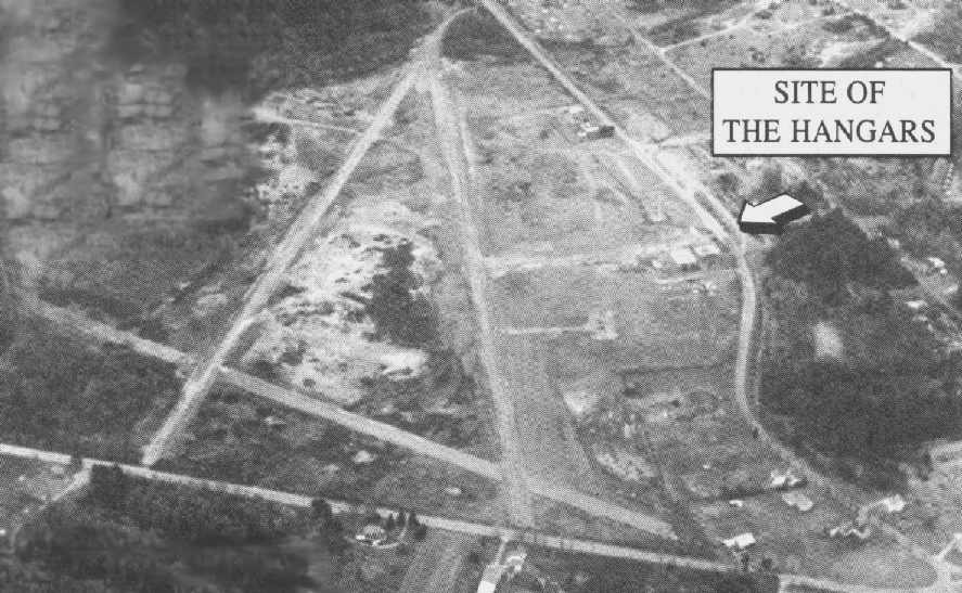
Steve Cohn reported in 2005, “The large building on the southwest side of the old Squantum NAS,
formerly used by the Jordan Marsh Company is now used by Boston Scientific.”
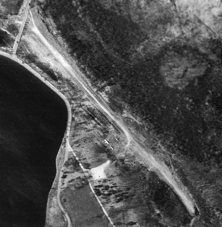
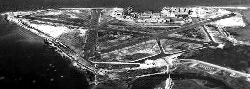
A circa 2007 aerial view looking east at the remains of Squantum runway pavement.
A January 2009 aerial view by Paul Freeman looking west at the remains of the northwest/southeast runway of Squantum NAS.
A 2016 aerial view showed the only remains of the northwest end of a Squantum NAS runway was still recognizable.
See also:
NAS Squantum: The First Naval Air Reserve Base
http://www.lulu.com/content/paperback-book/nas-squantum-the-first-naval-air-reserve-base/7634973
http://pirs.mvr.usace.army.mil/fuds/a-d/bostonh/preasses/inpr/inpr.htm
http://pirs.mvr.usace.army.mil/fuds/a-d/bostonh/oe/asr/findings/21.pdf
http://www.state.ma.us/film/feefree/squantum.htm
http://www.vpnavy.com/nassquantum.html
____________________________________________________
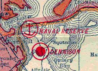
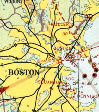
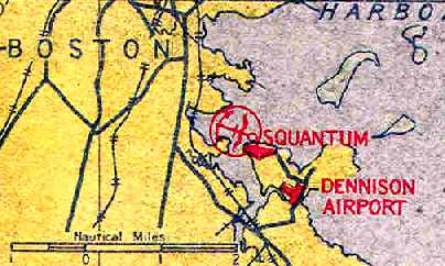
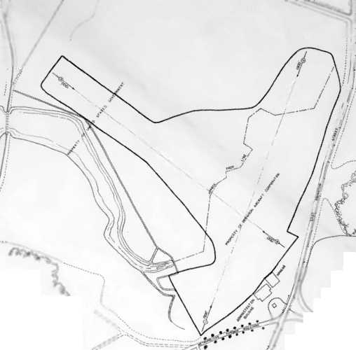
42.295, -71.033 (South of Boston, MA)
Dennison Airport, as depicted on the 1929 Rand-McNally Air Trails Map of Massachusetts (courtesy of Chris Kennedy).
According to Bill Deane of the Massachusetts Aviation Historical Society,
Dennison Airport, a small general aviation field, was constructed in the south side of the Squantum peninsula & opened in 1926.
One of the original financial backers of Dennison Airport was Amelia Earhart.
Amelia was a passenger on the first flight at Dennison Airport on 9/3/27. Later she learned to at Dennison Airport.
The earliest depiction of Dennison Airport which has been located
was on the 1929 Rand-McNally Air Trails Map of Massachusetts (courtesy of Chris Kennedy).
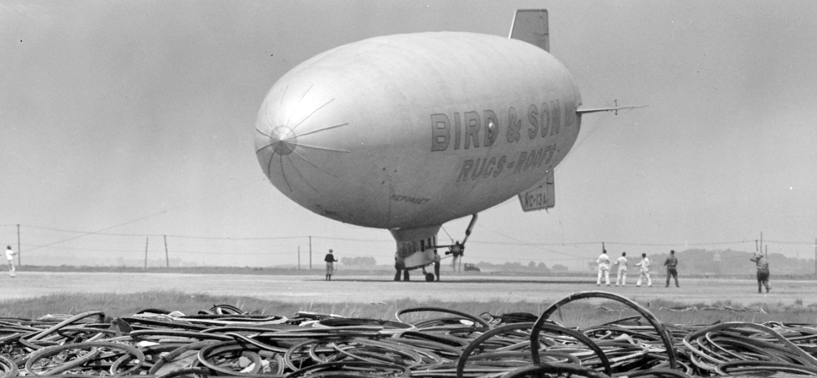
The earliest photo which has been located of Dennison Airport was a 1930 photo of the blimp Neponset advertising Bird & Son being moored (courtesy of Kevin Rutherford).
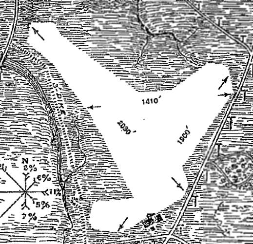
The 12/18/30 Commerce Department Airway Bulletin (courtesy of Jonathan Westerling)
depicted Dennison Airport as an irregularly-shaped field,
within which the longest landing area was 2,030' northwest/southeast.
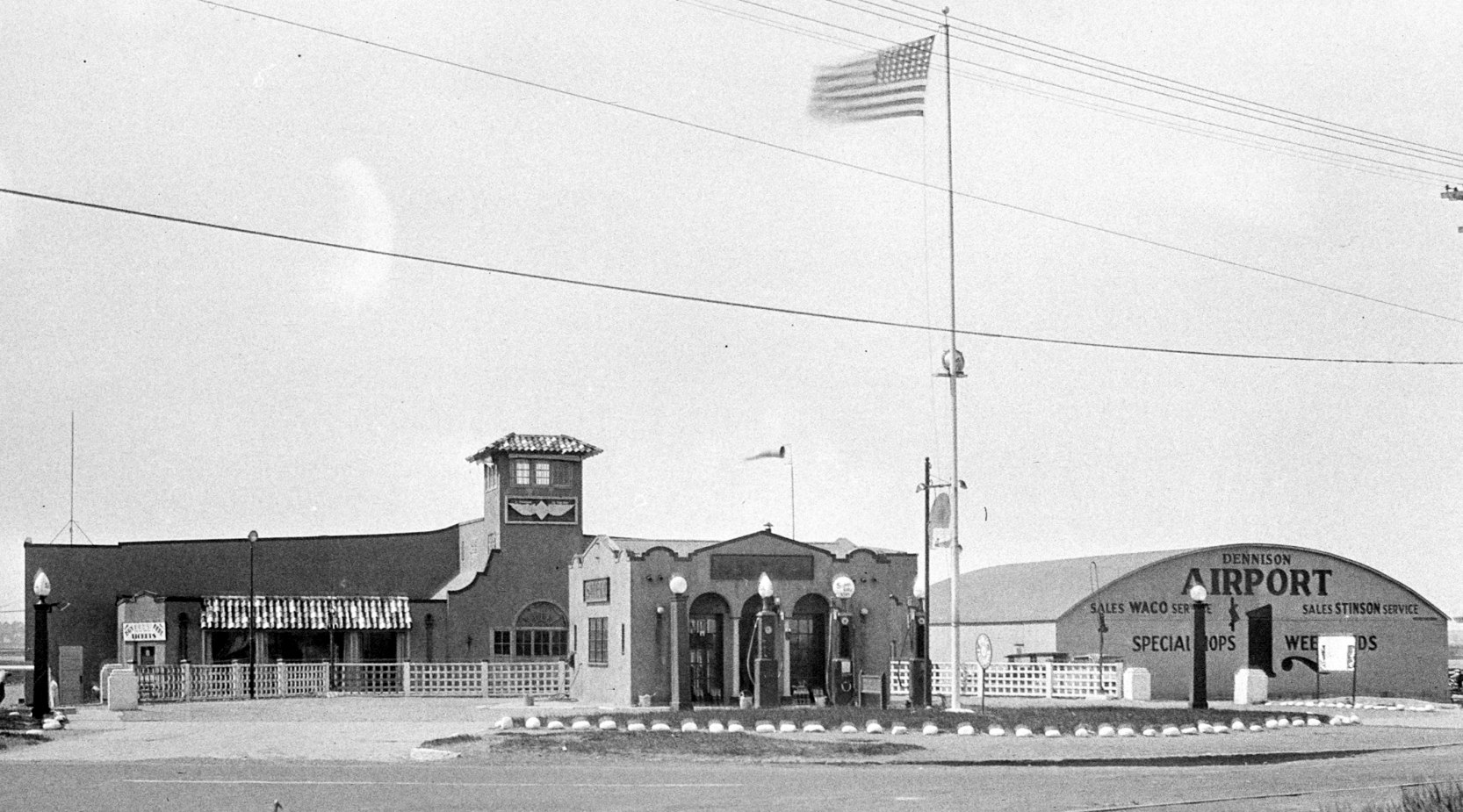
A 5/17/31 photo by Warren Parker of the Dennison Airport terminal & hangar (from the MA Digital Commonwealth).
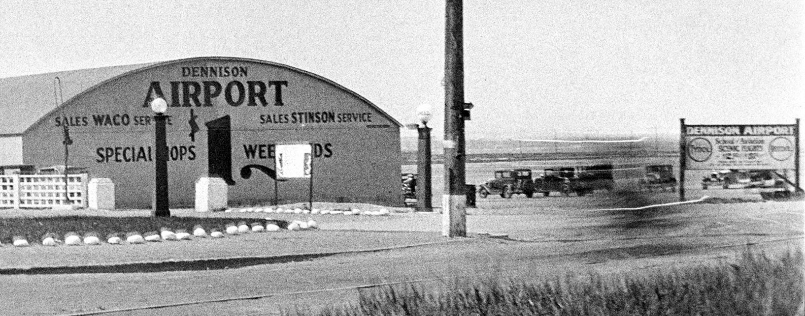
A 5/17/31 photo by Warren Parker of the sign in front of the Dennison Airport hangar (from the MA Digital Commonwealth).
The earliest aeronautical chart depiction which has been located of Dennison Airport was on the 1933 Boston Sectional Chart.
The 1934 U.S. Navy Aviation Chart (courtesy of Chris Kennedy)
depicted Dennison Airport as a T-shaped field, just to the southeast of NAS Squantum.
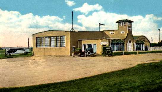
A circa 1930s colorized photo from a postcard of the Dennison Airport terminal/hangar (courtesy of Kevin Rutherford).
The location of Dennison Airport,
as depicted in the 1937 “Progress Report of the Committee For Aeronautics of the Commonwealth of MA” (courtesy of Jonathan Westerling).
The 1937 “Progress Report of the Committee For Aeronautics of the Commonwealth of MA” (courtesy of Jonathan Westerling)
depicted Dennison Airport as an irregularly-shaped 29 acre sandy clay field,
within which were 1,900' northeast/southwest & northwest/southeast landing areas.
It was described as a commercial airport, owned by the Dennison Airport Corporation & operated by the Dennison Airport Operating Company.
Two hangars, an administration building & a repair shop were depicted on the southeast side of the field.
The last photo which has been located showing planes at Dennison Airport was a 10/29/38 USN aerial view (from the MA Digital Commonwealth).
It showed 2 light planes near the hangars on the southeast corner of the unpaved airfield.
The last aeronautical chart depiction which has been located of Dennison Airport was on the November 1939 Boston Sectional Chart.
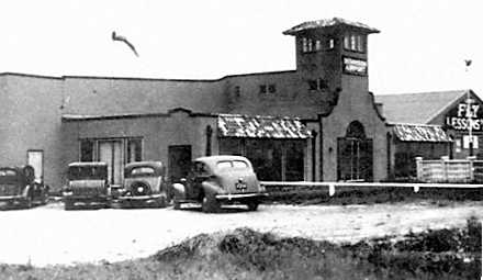
A circa 1940 photo (courtesy of Tom Norris) of the Dennison Airport terminal, with “Fly Lessons” visible on the building to the right.
Tom noted, the building was “very unusual with its Mission Revival design.
I wonder if that tower was for operation or observation?”
Dennison Airport was evidently closed at some point between 1937-41, as the May 1941 Boston Sectional Chart no longer depicted Dennison.
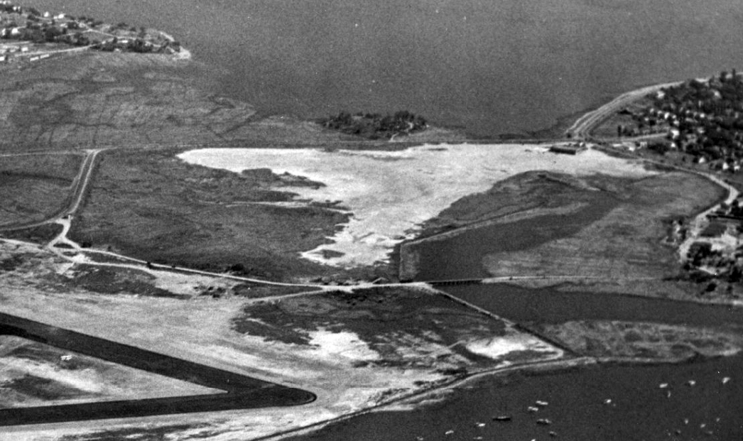
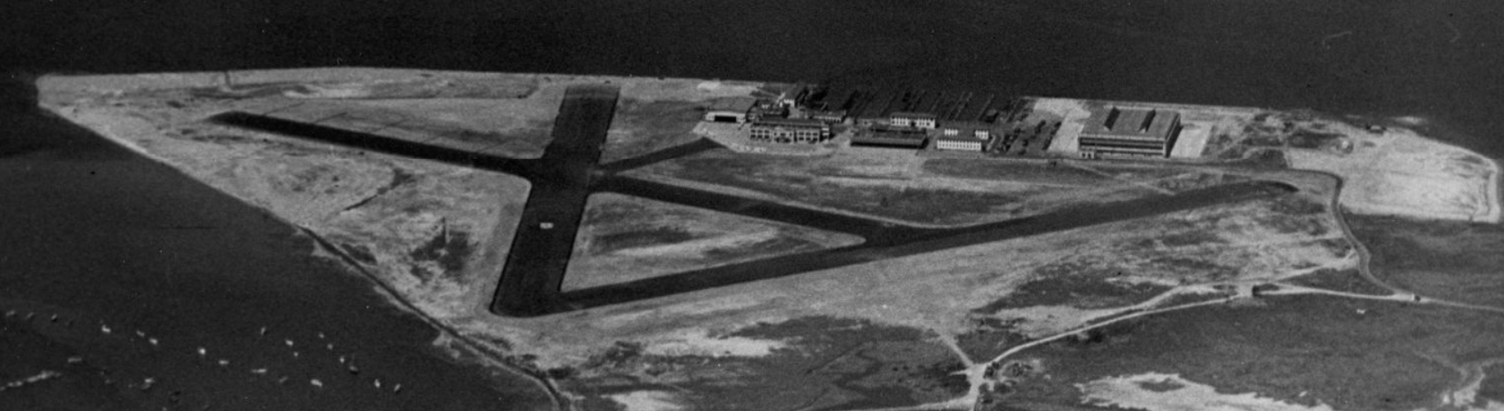
The last photo which has been located of Dennison Airport was an 8/11/41 USN aerial view looking east (from the MA Digital Commonwealth, courtesy of Kevin Rutherford).
Dennison Airport was visible as a light-colored clearing, with the terminal building on the south (top-right).
The asphalt runways of adjacent NAS Squantum were visible at bottom-left.
According to Bill Deane of the Massachusetts Aviation Historical Society,
Dennison Airport ceased operations in “1942 when it was closed & the land was taken over by the USN for the creation of NAS Squantum.”
The last labeled depiction which has been located of Dennison Airport was on the 1943 USGS topo map.
A March 1943 aerial view looking southeast at NAS Squantum showed a road had been built at some point between 1941-43 right through the center of the former Dennison Airport (top of image).
The 1944 USGS topo map no longer depicted Dennison Airport, but rather depicted the Squantum “U S Naval Reservation” as having covered the airport site.
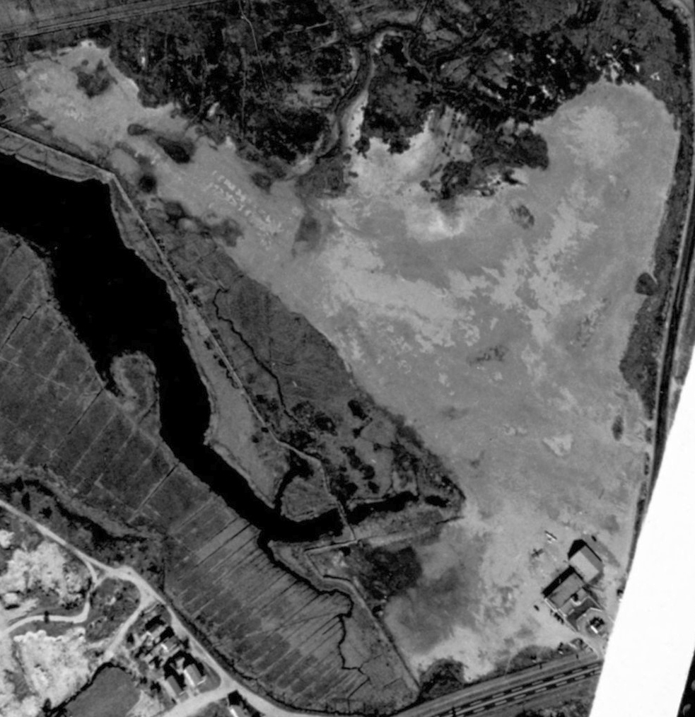
Kevin Rutherford reported in 2011, “Dennison Airport mostly exists today at almost sea level.
I doubt that they restored the marsh, so I think that it always existed as this (although part of a runway is above sea level).”
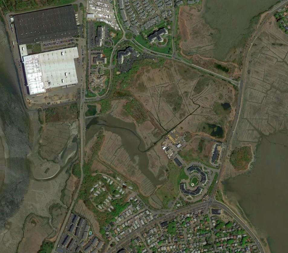
A 2016 aerial view did not show any remaining trace of Dennison Airport.
The site of Dennison Airport is located southwest of the intersection of East Squantum Street & Victory Road.
____________________________________________________
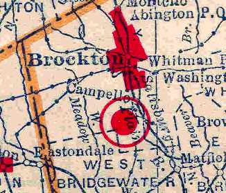
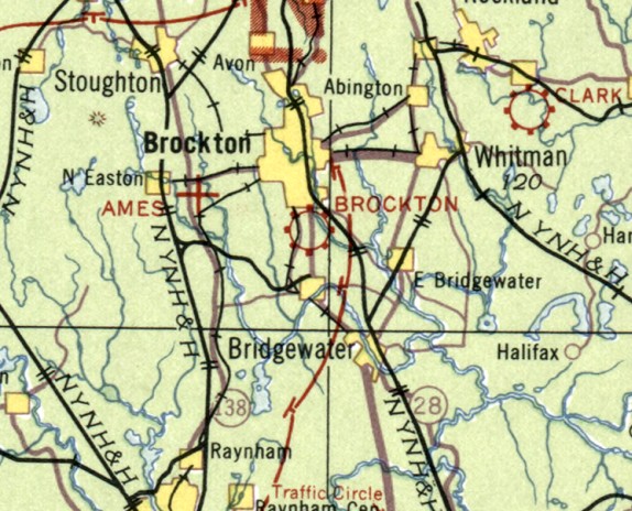
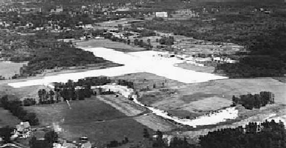
Brockton Airport, Brockton, MA
42.045, -71.016 (South of Boston, MA)
Brockton Airport, as depicted on the 1929 Rand-McNally Air Trails Map of Massachusetts (courtesy of Chris Kennedy).
The date of construction of this small general aviation airport has not been determined.
According to an article in the Enterprise by Jennifer Kovalich (courtesy of Richard Griffith),
Brockton Airport sprang up in the 1920s on Main Street in Campello & had a single gravel runway.
The earliest depiction of Brockton Airport which has been located
was on the 1929 Rand-McNally Air Trails Map of Massachusetts (courtesy of Chris Kennedy).
It described the field as a commercial airport, operated by the Brockton Airport Company.
The field was said to be quite small, measuring only 2,100' x 800' in size.
Brockton Airport, as depicted on the March 1933 Boston Sectional Chart.
In the mid-1930s, Robert Hanitsch took his first airplane ride at Brockton Airport in a Ford Trimotor
Robert & his father boarded the plane parked on the gravel strip.
His father took the middle seat, allowing his son to sit near the window.
The youngster immediately leaned over & pressed his nose to the glass, looking down.
Andy Ward took his first airplane ride at Brockton Airport in 1936.
At the age of 12 with money in his pocket & a Western Union uniform on his back,
he paid 75 cents to ride in the co-pilot's seat.
The experience made an indelible impression on the pre-teen even as he made his way to the front of the airplane.
"Some wise guy said, 'If that's the pilot, I'm getting off,'" Ward recalled.
The Ford Trimotor, to his surprise, lifted easily into the air.
"When they took off, I thought they were never going to clear the wires off South Main Street," Ward said.
The 1937 “Progress Report of the Committee For Aeronautics of the Commonwealth of MA” (courtesy of Jonathan Westerling)
depicted Brockton Airport as an irregularly-shaped 51 acre sod field,
within which were 2 gravel runways: 1,450' east/west & 1,300' north/south.
It was described as a commercial airport, owned by James Keith & operated by Lyle & Ames, Brockton Airport.
A metal hangar & a wooden office building were depicted on the east side of the field.
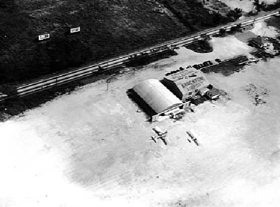
The earliest photo which has been located of the Brockton Airport
was an undated aerial view from The Airport Directory Company's 1938 Airport Directory (courtesy of Jonathan Westerling).
The directory described Brockton as having 2 gravel 1,400' runways, and a few small buildings were visible on the east side of the field.
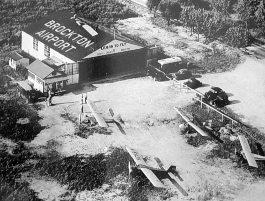
A circa 1940-41 aerial view looking northeast at 4 light aircraft around the Brockton Airport hangar (courtesy of Matt Elia).
A circa 1940-41 photo of a crown gathered around several aircraft at the Brockton Airport hangar (courtesy of Matt Elia).
The 1941 USGS topo map labeled the site as "Brockton Airport",
but the only details depicted at the site were several small buildings along the periphery of the field.
No runways were depicted.
Brockton Airport, as depicted on the 1945 Sectional Aeronautical Chart.
In 1945, N.A. Trager & Joe Messina (who were both WW2 Army Air Corps flight instructors)
decided on a handshake to form a business called Brockton Airways.
The two dickered with property owner James Keith & leased the airport property,
later purchasing it while Keith held the mortgage.
N.A. Trager described Keith as a "Mid-western cowboy transplanted to Brockton."
Trager, a former West Bridgewater resident who now lives in Sunny Isles Beach, FL, said Keith never learned to fly.
"He had no interest in flying," Trager said. "I don't think he was interested in anything faster than a horse."
Trager & Messina operated Brockton Airways together for 18 months, starting the venture in October 1945.
During that time, the airport trained numerous war veterans who learned to fly on the G.I. Bill.
Robert Hanitsch, who years before had taken his first flight at the airport, was hired as a flight instructor
and Jean Mirling (later to become Jean Hanitsch) worked as the secretary.
During their time at Brockton Airways, Jean Hanitsch said about 150 ground boys took flying lessons.
At a time when the weekly wage was between $35 & $40, solo flying lessons cost $8 an hour.
The airport also offered $2 flights around Brockton on Sundays.
Flight instruction was given in Piper Cubs.
The airport also boasted Aeroncas, Taylorcraft, PT-19s, BT-13s, single & twin-engine Cessnas,
as well as a Stearman biplane.
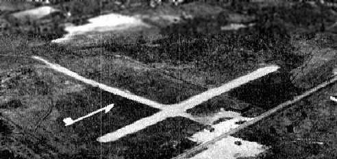
Under Trager's direction, the airport expanded to have 2 runways (north/south & east/west) & 2 hangars.
In the winter, planes were equipped with skis as the runways were not plowed.
"It was easy to land," Hanitsch said.
There was also a restaurant called The Stair Club, which was operated by 2 brothers, the late Ken & Bob Fisher.
Jean Hanitsch said in the good weather the airport operated from dawn to dusk.
"They had to make money when they could," she said.
Her husband gave flying lessons to one aspiring pilot after another.
The airport was also the home of the Brockton Flying Club.
It was a popular destination, particularly on Sundays when cars lined the fence to watch the planes take off & land.
A circa 1946 aerial view of Brockton Airport by Andy Ward.
A circa 1946 aerial view of the hangar & office at Brockton Airport by Andy Ward.
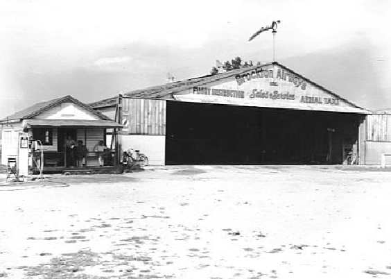
A circa 1946 photo by Andy Ward of the Brockton Airways hangar & ready room.
The building shown was the former 'Bob & Ken's Hangar Restaurant'."
David Keith recalled, "I lived about a mile from the old Brockton Airport,
which had a North/South runway of about 2,000',
and an East/West runway of less than 1,500', with telephone wires at both ends.
My house was right under the downwind for Runway 36,
and immediately after World War Two, it was a beehive of activity, with a thriving GI Bill flight school.
There were J-3's, Commonwealth Skyrangers, and old Aeronca's, the pre-7AC types with exposed cylinders,
just swarming around the pattern.
They got to be old hat to this 12-year-old veteran spotter,
but when something unusual showed up, like a BT-13, DGA or AT-6, that really got my attention!
I'd be on my Schwinn Black Phantom in a flash, and would high-tail it to the field in record time."
David continued, "I got to be a professional chain-link fence-hangar, and gradually got to know all the instructors, the owner,
and his beautiful, blonde secretary, on whom I had a serious crush.
My parents had given me a stern warning not to go flying, but finally, the siren song of the air got the better of me.
The airport owner, Nat Trager, offered to take me up in his Aeronca Chief.
I climbed into the right seat, one of the instructors propped us, and before I knew it, we were rolling for takeoff.
I couldn't believe the din that little Continental made!
I'll never forget looking down to my right, and watching the ground fall away, as if by magic.
At that moment, I was hooked for life!
I don't remember much more of the flight, except that the door & window next to my elbow was vibrating & rattling,
and I was hoping that that Air-Knocker would hold together for just a few more minutes.
I guess it was at least a year before I got up the courage to tell my folks that I had been for an airplane ride."
David continued, "One time, a Tin Goose flew in & hopped rides.
I would have been their first customer, but I wasn't home, and heard about it too late.
There were a few crack-ups over the years, but I never heard anyone call for the closure of the field.
The Brockton Flying Club kept its plane there, and they had their clubhouse in a barn, just off the end of Runway 27.
They started in 1931 with a Curtiss Junior, a tandem, open-cockpit, parasol pusher with a 3-cylinder, radial Szekely engine, of 36 hp."
David continued, "I used to visit that old barn, years after it was no longer used as the clubhouse.
There were 2 old hulks brooding inside,
fuselages bereft of wings, and I would sit in them, wiggling the joystick & rudder pedals in the midst of a Mitty-esque dream,
and inhale the perfume of old dope & stale avgas.
Those ships were the best simulator a kid could ever have!
I also remember seeing a hangar packed full of Cubs like sardines,
sitting on their noses with tails in the air, allowing 3 or 4 times as many to be stored."
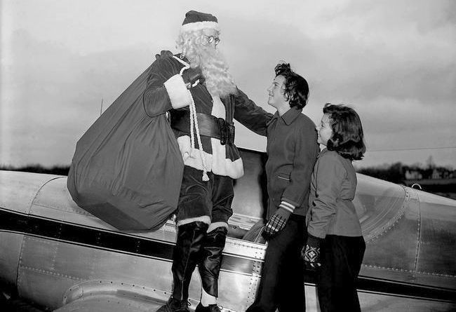
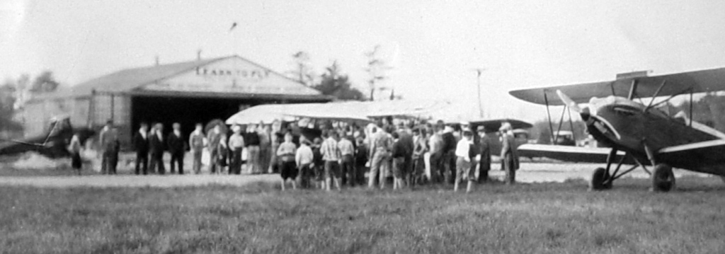
The last photo which has been located of Brockton Airport while it was still in operation
was a December 1950 of Santa Claus being greeted by Judy & Harriet Mechaber on a Globe Swift (courtesy of Brian Hawes).
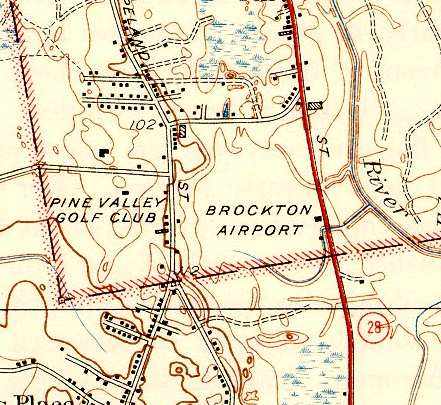
Brockton Airport, as depicted on the 1951 USGS topo map.
After Trager & Messina ran the airport for 18 months,
Messina partnered with 2 other men in running a crop dusting business from a Wareham airport.
At the same time, Trager began operating a crop-dusting service for cranberry bogs from Brockton Airways,
using a converted J-3 Piper Cub.
"It was very successful," Trager said.
Trager had hired an experienced southern pilot to fly his crop duster. He urged Messina to do the same.
However, his one-time partner opted to fly himself.
He died in a crop-dusting accident, and the Wareham airport was phased out.
"He was a great fellow. One of the finest fellows I've ever met," Trager said.
As the city evolved, Brockton Airways struggled to stay alive.
"I believe it would have been better if we had city support," Trager said.
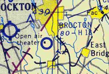
Brockton Airport was still depicted (although misspelled!) on the November 1954 Boston Sectional Chart (courtesy of Chris Kennedy),
but the Aerodromes table listed the field as "Closed".
It was said to have an 1,800' hard surface runway.
The "open air theater" which was depicted immediately adjacent to the airport was the Sky-View Drive-In movie theater,
which had been built on the southwestern corner of the former airport site.
By the time of the May 1955 Boston Sectional Chart, Brockton Airport was no longer depicted at all.
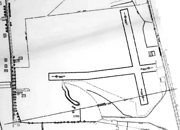
A 1960 aerial viewed of the site of Brockton Airport
showed that the majority of the length of the north/south paved runway & parallel taxiway remained intact,
as well as a hangar on the east side of the site.
A east/west road had been built across the southern portion of the runway,
leading to a drive-in movie theater on the southwest side.
A 1971 aerial view of the site of Brockton Airport showed that the majority of the length of the north/south paved runway & parallel taxiway remained intact,
as well as a hangar on the east side of the site.
A shopping center had been built over the southeast part of the airport site.
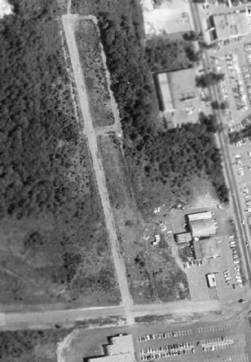
In the 1995 USGS aerial photo of the site of Brockton Airport, the South Shopping Center had covered the remaining portions of the airport.
Not a trace appeared to remain of the former airport.
Although Brockton Airways is but a memory, Jean & Robert Hanitsch, Ward and Trager remain friends.
None has lost their affection for the wonder of flight.
Robert Hanitsch's blue eyes shine as he recalls swooping in & around big white puffy clouds.
"It gets in your blood," he said.
"Flying to me was something that was very satisfying, I could even use the word 'thrilling,'" Trager said.
"I would like to do it all over again."
Years later, Andy Ward still thinks about the old airport.
"I kind of miss the fact that we had an airport & we gave it up," Ward said.
In the words of David Keith, "People who shop at K-Mart Plaza in Brockton, these days,
don't know that there's an airport under their feet, with ghosts of rag-wing planes, hovering above."
A 2019 aerial view looking north showed no trace remained of Brockton Airport.
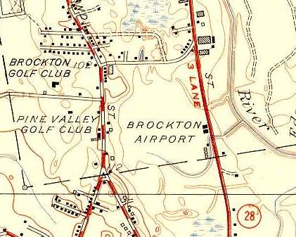
The site of Brockton Airport is located southwest of the intersection of Main Street & Hayward Avenue.
Thanks to Richard Griffith for pointing out this airfield.
____________________________________________________
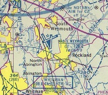
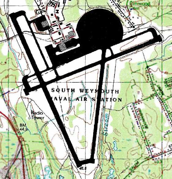
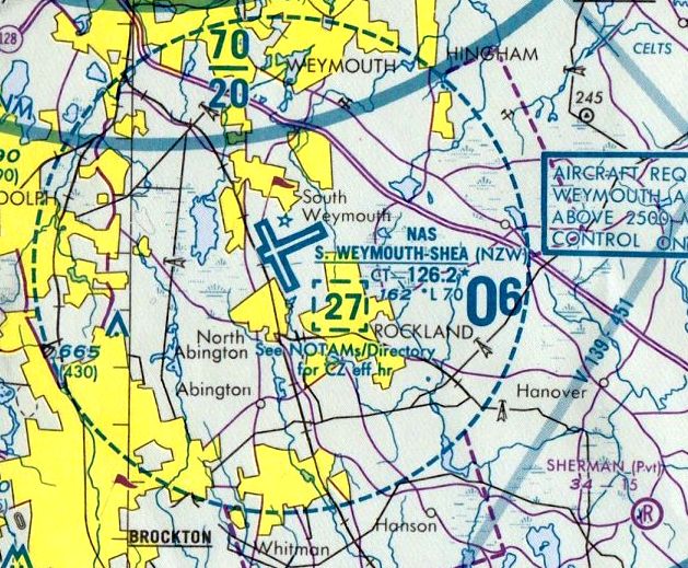
South Weymouth NAS / Shea Field, South Weymouth, MA
42.15, -70.94 (South of Boston, MA)
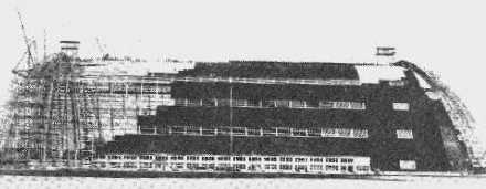
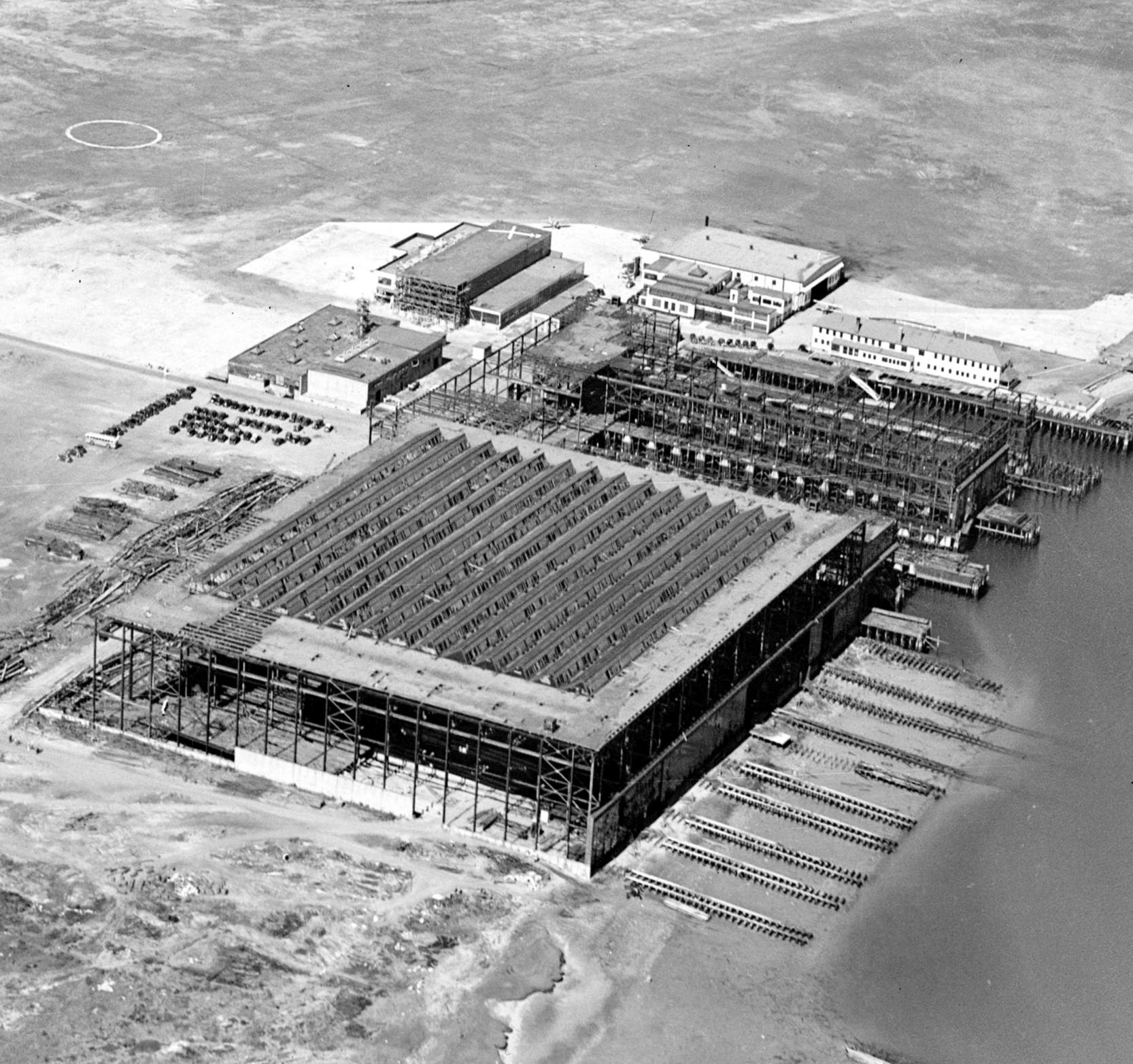
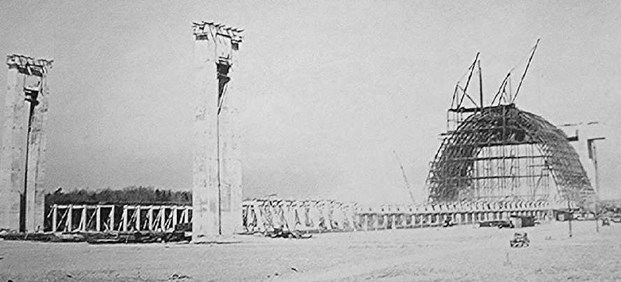
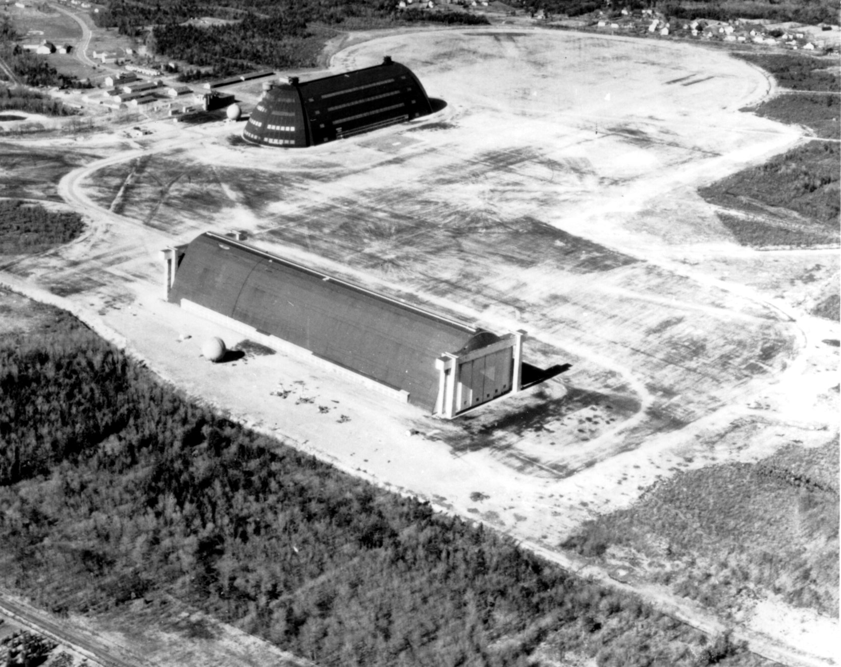
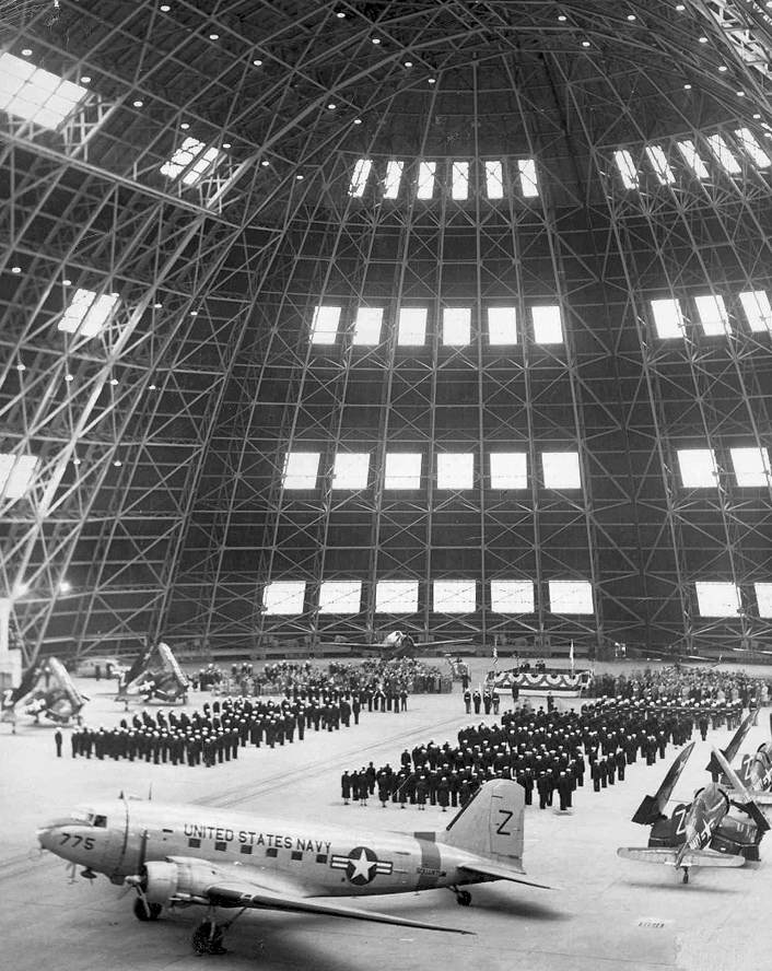
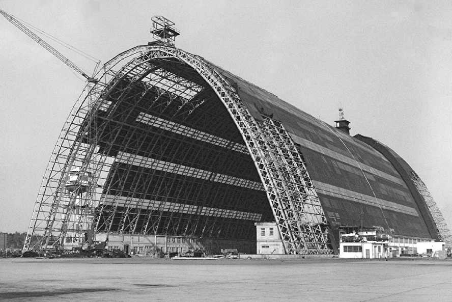
A 1942 photo looking north at South Weymouth's massive Hangar 1 while under construction
(courtesy of Bill Sargent, Board of Directors, Naval Aviation Research, Weymouth Historical Society).
Bill remarked, “The metal construction 'Traveler' with its upper stiff derricks can be seen in the framework at the western end of the all-metal structure.”
The property which would eventually become South Weymouth NAS was surveyed in 1938 for a proposed municipal airport.
NAS South Weymouth was not yet depicted on the 1941 USGS topo map
nor on the November 1942 Boston Sectional Chart.
The earliest photo which has been located of NAS South Weymouth was a 1942 photo,
showing the massive Hangar 1 while under construction
(courtesy of Bill Sargent, Board of Directors, Naval Aviation Research, Weymouth Historical Society).
Rick Jones observed, “You can see one of the 2 original control towers built atop the hangar.
Originally the design called for one in the center,
but the immense size of the hangar blocked the ground view so it was decided to include an additional tower, positioned at each end.
Access to them was on a suspended arched catwalk inside the hangar.
On very humid days the condensation that built up inside due to the cooler temperature sometimes caused it to 'rain' inside.”
South Weymouth was eventually commissioned in 1942 as one of the Navy's ASW blimp bases.
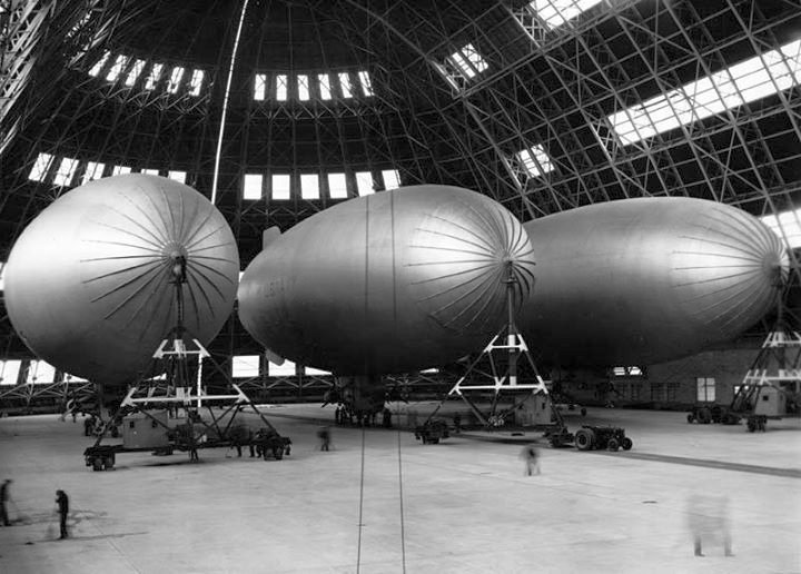
A 12/6/42 photo of 3 US Navy K-class airships from Airship Patrol Squadron ZP-11 inside NAS South Weymouth's Hangar One.
A 4/27/43 photo of the construction of South Weymouth's Hangar 2 (Building 59)
(courtesy of Bill Sargent, Board of Directors, Naval Aviation Research, Weymouth Historical Society).
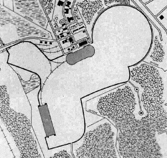
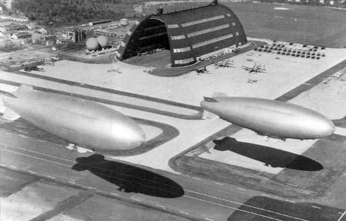
One of South Weymouth 's massive blimp hangars was the world's second largest blimp hangar, measuring 956' across.
The base had a 2,000' diameter blimp mat, 6 mooring circles, and a 4,500' grass runway.
South Weymouth operated a complement of 12 blimps.
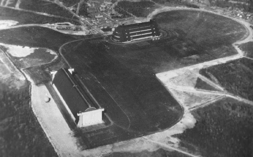
A WW2-era view looking northeast at the 2 blimp hangars at South Weymouth (National Archives photo).
The earliest aeronautical chart depiction which has been located of NAS South Weymouth was on the November 1943 Boston Sectional Chart.
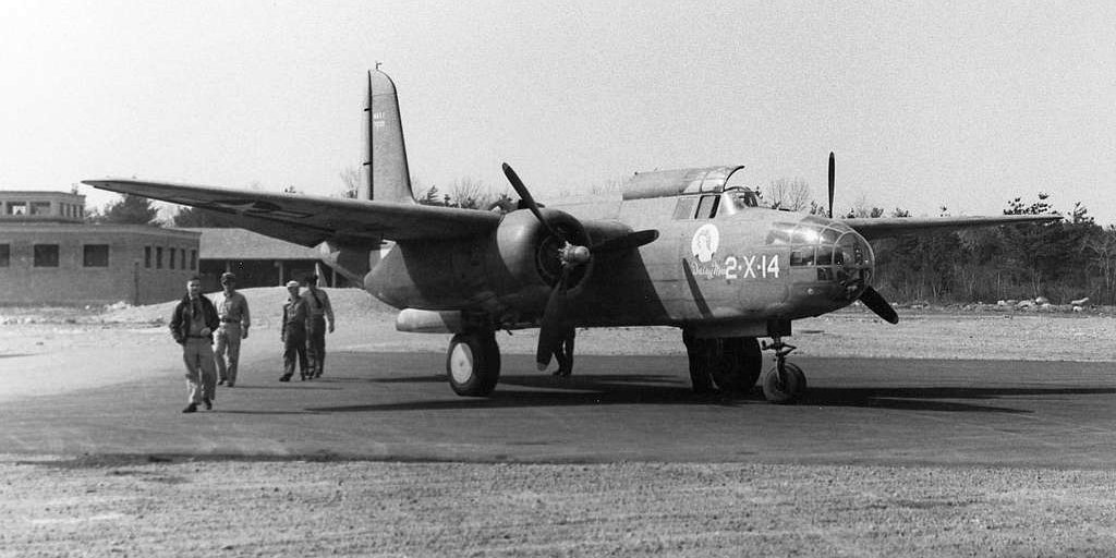
A 1944 USN photo of a Navy Douglas BD-2 of Experimental Squadron VX-2 at Naval Air Station South Weymoth, with Daisy Mae nose art.
The BD-2 was the Navy version of the A-20; with armament removed, they were employed for target towing & general utility duties.
The 1945 AAF Airfield Directory (courtesy of Scott Murdock) described South Weymouth NAS as a 1,256 acre property,
within which was an oiled gravel landing area, with the longest dimension being 4,450' east/west.
The field was said to have 2 hangars: 1,058' x 296' wood & concrete & 960' x 337' steel.
Following WW2, South Weymouth was downgraded to a Naval Air Facility.
It was used to store surplus amphibian aircraft, and it was placed into caretaker status in late 1945,
being designated as a Naval Aircraft Parking Station.
Curiously, nothing at all was depicted at the location of NAS South Weymouth on the 1947 Army Map Service topo map.
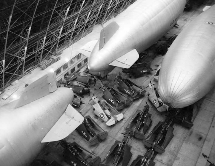
A 9/14/44 photo of Navy K-class airships of Airship Patrol Squadron ZP-11 & over a dozen TBM Avengers in hurricane storage inside a NAS South Weymouth blimp hangar.
A 9/14/44 USN photo of the interior of a South Weymouth blimp hangar, showing 5 blimps & an amazing variety of fixed-wing aircraft stored simultaneously inside the massive hangar.
According to Rick Jones, this photo might have been taken during “the hurricane of 1944, when they crammed as many, if not all, of the base aircraft inside for protection.”
The 1949 Boston Local Aeronautical Chart (courtesy of Tim Zukas)
depicted NAF South Weymouth as having 2 dirigible hangars & a 4,500' unpaved runway.
South Weymouth was closed by the Navy in 1949.
A circa late 1940s / early 1950s aerial view looking northeast at the 2 blimp hangars at South Weymouth.
The base was devoid of aircraft, so the photo was presumably during the base's closure from 1949-53.
South Weymouth was substantially rebuilt & then reactivated during December 1953
to take over the Navy & Marine Corps reserve operations from NAS Squantum,
which was closed due to airspace conflicts with the Commonwealth Airport in East Boston (modern-day Logan International Airport)
and short runways that were unsuitable for routine jet operations.
During South Weymouth's reconstruction for the Reserve program
the wooden blimp hangar, Hangar Two, was demolished & 3 paved runways were built.
A circa 1940s view of the first helicopter to visit South Weymouth – a Sikorsky R-4,
in front of a the massive blimp hangar & a row of 4 blimp mooring towers.
Robert Ervin recalled, “Ed Brennen & I stood the last watch in the NAS Squantum tower sometime in November of 1953
and the next day we reopened NAS South Weymouth.
Naval Air Defense Unit was stationed [at NAS Squantum]
and as their fleet expanded into Super G Constellations (WV-2) & ZPG-2W, the worlds largest blimps,
it was necessary to relocate to South Weymouth as they had a much longer north/south runway
and a blimp hangar with a fine blimp mat at the northeast end of the runway.”
A 12/8/53 photo of ceremony (change of command?) inside the South Weymouth blimp hangar (courtesy of Marc Senger).
Aircraft visible include a Douglas R4D-6 Skytrain BuNo 50755 c/n 26138 'Z-755', Chance-Vought F4U Corsairs, and a Grumman TBF Avenger.
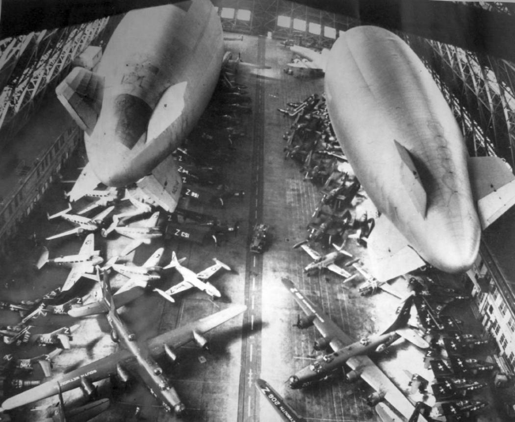
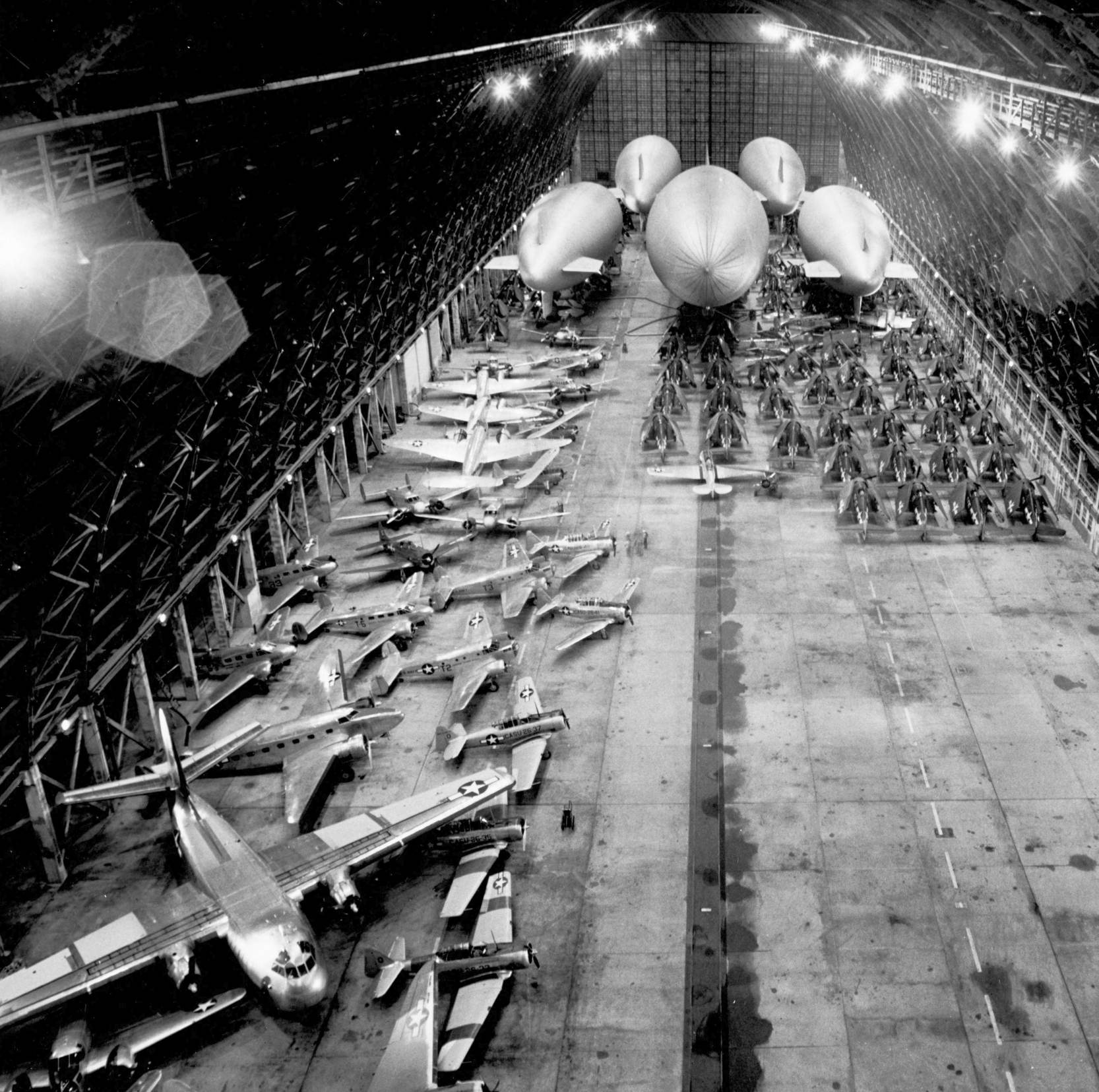
A remarkable August 1954 photo showing an amazing assemblage of aircraft, including 2 blimps, and dozens of jet & piston-engine aircraft,
stored inside the massive South Weymouth blimp hangar in preparation for hurricane Carol.
A circa 1950s aerial view looking southwest at South Weymouth,
showing a blimp & 3 P-2 Neptunes on the circular pad, another plane taxiing, and at least 2 planes parked next to Hangar 1.
A 4/22/57 USGS aerial view showed a wide variety of jet & propeller aircraft on the NAS South Weymouth ramps & blimp mooring pad.
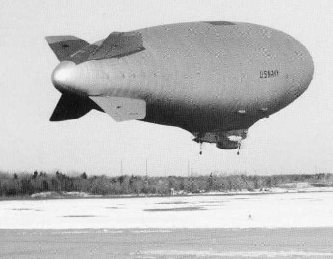
A 3/13/57 photo of a ZPG-2 airship being marshaled by ground handlers just before takeoff from NAS South Weymouth.
An 4/11/58 photo of the wreckage of an unidentified Navy blimp which collapsed from the weight of heavy snow in front of South Weymouth Hangar #1 (from the MA Digital Commonwealth).
In 1959, the South Weymouth airfield was improved to support increased numbers of fixed-wing ASW & attack squadrons,
resulting in 2 paved runways of 7,000' & 6,000' length.
It was at this point presumably that the blimp hangar on the southwest side was removed to make way for the expanded airfield,
leaving only 1 remaining blimp hangar (Hangar #1).
A circa late 1950s / early 1960s aerial view looking northeast at 2 Navy blimps in flight over South Weymouth,
with Hangar 1 in the background, and what appear to be 2 P-2 Neptunes & 2 Lockheed WV-2 Warning Stars on the ramp.
NAS South Weymouth, as depicted on the 1960 Boston Local Aeronautical Chart (courtesy of Mike Keefe).
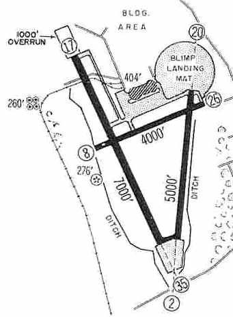
The 1960 Jeppesen Airway Manual (courtesy of Chris Kennedy) depicted South Weymouth as having 3 paved runways,
with the longest being the 7,000' Runway 17/35 (which had an additional 1,000' overrun).
The blimp landing mat was still depicted, as was the blimp hangar.
Blimp operations were discontinued at South Weymouth by the early 1960s.
A map of NAS South Weymouth from the 1963 air show program
“A Salute to the Navy's Golden Wings: Naval Air Station South Weymouth” (courtesy of Robert Randall).
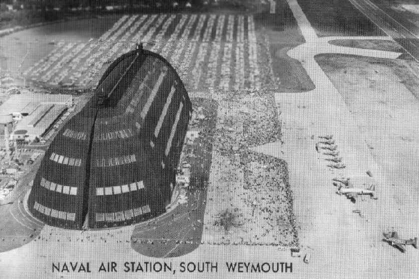
An aerial view looking east at South Weymouth's Hangar #1 during the 1962 Open House Air Show,
from the 1963 air show program (courtesy of Robert Randall).
The F11F-1 Tigers of the Blue Angels are lined up on the right side.
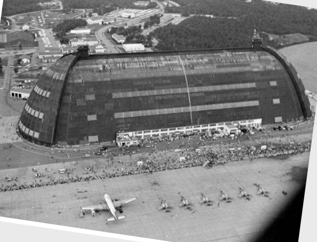
An aerial view looking north at South Weymouth's Hangar #1 during the 1962 Open House Air Show (courtesy of Marc Senger),
with the F11F-1 Tigers of the Blue Angels lined up in front of the crowd.
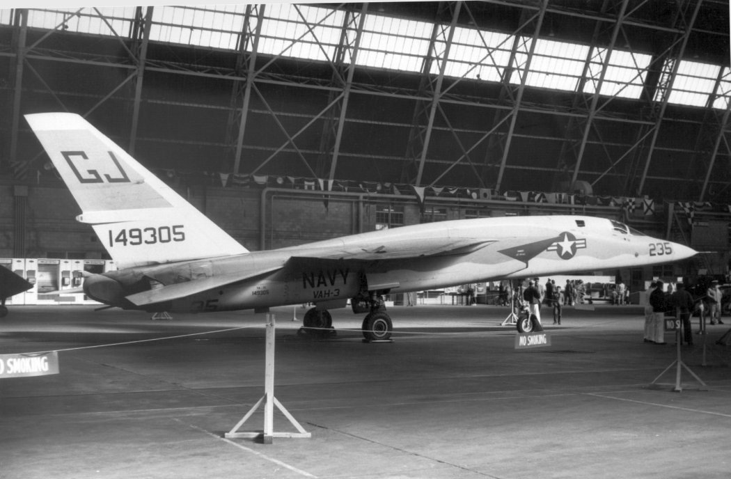
A circa 1963 photo of a beautiful Navy North American YA-5C Vigilante (BuNo 149305)
of Heavy Attack Squadron 3 on display inside the massive NAS South Weymouth blimp hangar.
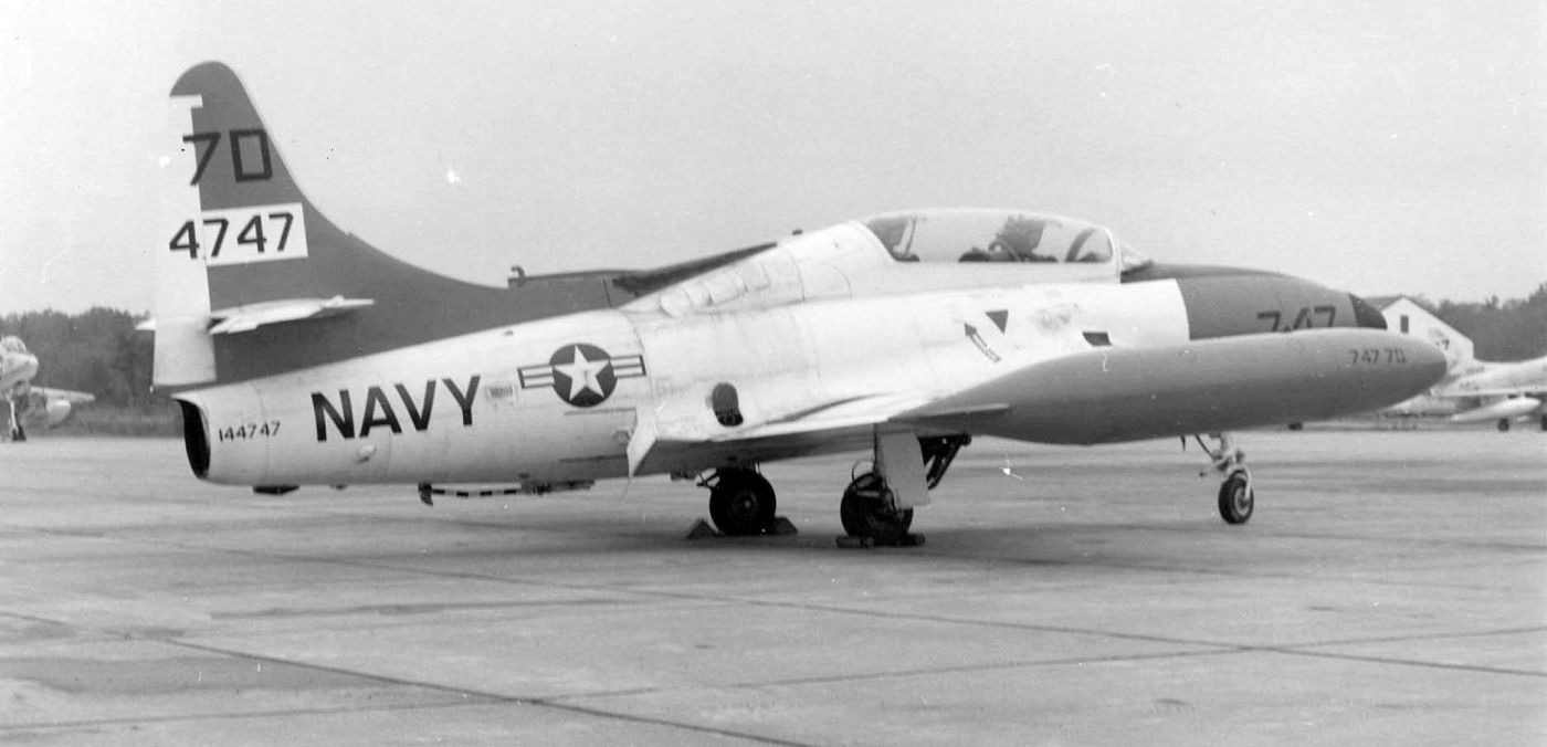
A circa 1963 photo of a Lockheed T2V Seastar assigned to Naval Air Reserve Training Unit Dallas TX seen at NAS South Weymouth (from the National Museum of Naval Aviation).
An undated view of 2 early flight simulators at NAS South Weymouth, from the 1963 air show program (courtesy of Robert Randall).
Two aircraft which were chalked off as total losses (a Grumman S-2A damaged in a crash landing & a Lockheed SP-2E damaged by fire)
were converted to Anti-Submarine Warfare Operational Flight Trainers, for a total installation cost of only $5,000.
They consisted of the aircraft fuselages, with associated ASW electronic systems,
and they were installed on the flat roof adjoining the ASW training spaces in Hangar #1.
The OFTs were credited with improving South Weymouth's ASW training program “by more than 100%.”
Rick Jones observed, “It cost $800 in 1966 each time the hangar doors were opened & closed.”
A 6/9/66 photo of a crowd gathered around the Gemini 9 space capsule in front of South Weymouth Hangar #1 (from the MA Digital Commonwealth), only a few months before the hangar was dismantled.
John Gamel recalled, “I think that at least one of the blimp hangars was still erect in late 1966
when I went to NAS South Weymouth for my flight physical before OCS.
I seem to recall that there were some USMC A-4s & some USN P-2s on the flight line at that time.”
A circa late October / early November 1966 view looking northeast at the dismantling of South Weymouth's Hangar 1
(courtesy of Bill Sargent, Board of Directors, Naval Aviation Research, Weymouth Historical Society).
According to Ron Plante, ”The last of the 2 blimp hangars was torn down in 1966 & replaced by a concrete arch hangar.”
NAS South Weymouth, as depicted on the 1968 Boston Sectional Chart (courtesy of Chris Kennedy).
A 1969 aerial view of South Weymouth's ramp showed 3 Lockheed P-2 Neptunes, as well as 5 smaller aircraft & helicopters.
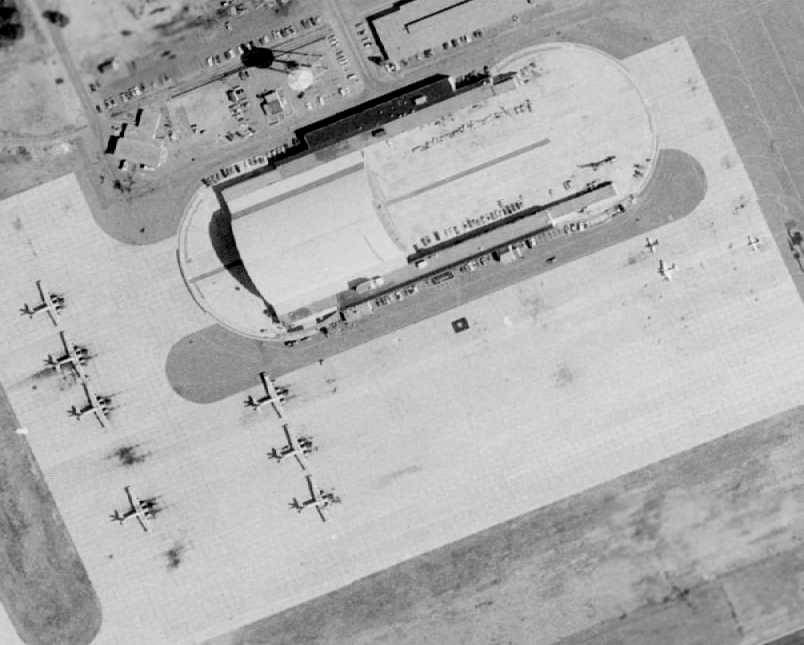
A 1971 aerial view of South Weymouth's ramp showed 7 Lockheed P-2 Neptunes, as well as 3 light aircraft.
Note the concrete arch hangar which was built over the western third of the foundation of a former blimp hangar.
USNR Commander (Retired) Ken Sherman recalled, “I flew from NAS South Weymouth from 1972-95, in both P-2s & P-3s.”
A 8/18/73 photo by Tom Hildtreth of a beautiful North American RA-5C Vigilante at South Weymouth.
The July 1975 Boston Terminal Aeronautical Chart (courtesy of Mitchell Hymowitz)
depicted NAS South Weymouth as having 3 paved runways, with the longest being 7,000'.
An 8/2/76 photo by Tom Hildtreth of a USMC Douglas A-4E Skyhawk at South Weymouth.
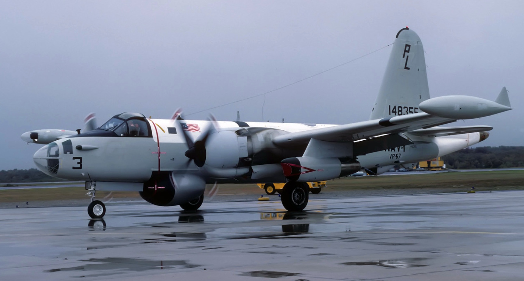
A 9/10/76 photo of Lockheed SP-2H Neptune 148355 of VP-67 at NAS South Weymouth.
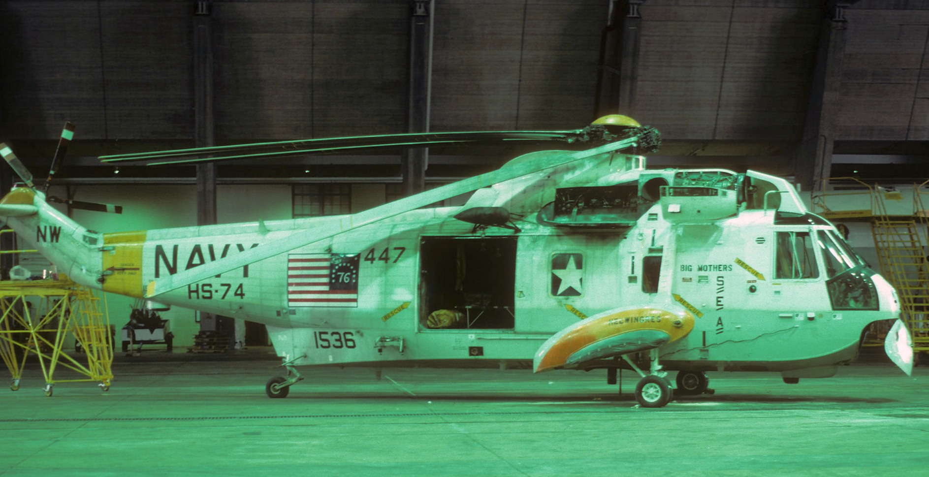
A 9/10/76 photo of Sikorsky SH-3H Sea King 151536 of HS-74 at NAS South Weymouth.
Jeffrey Geibel recalled that he obtained his Commercial & CFI ratings "at the Navy Weymouth Aero Club from 1977 to the club's closure in 1984."
A 4/23/78 USGS aerial view showed P-3 Orions on NAS South Weymouth's main ramp & smaller jet aircraft on its northwest ramp.
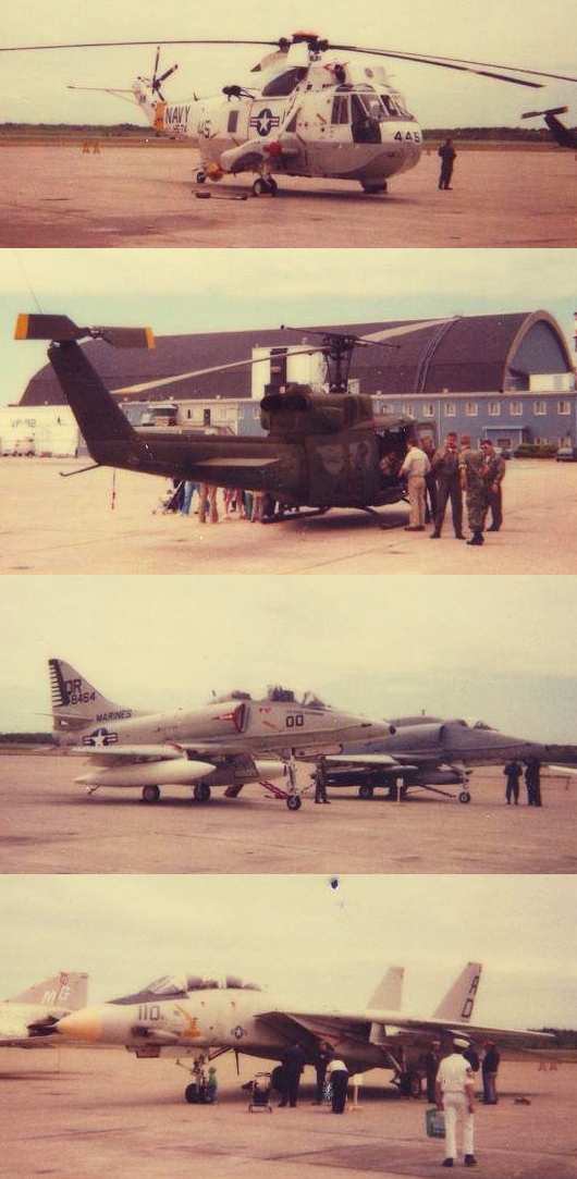
A series of circa-1985 photos by Peter Kodis of aircraft at South Weymouth: an SH-3, UH-1, A-4s, and F-14.
The June 1985 NY Sectional Chart (courtesy of Mitchell Hymowitz)
depicted NAS South Weymouth as having 2 paved runways, with the longest being 7,000'.
The 1988 USGS too map depicted South Weymouth NAS
as having 3 paved runways, taxiways, ramps, 2 hangars, and the giant paved blimp mooring circle.
John Gamel recalled, “Oddly enough, a 22-year career in the FBI brought me back to NAS South Weymouth in late 1990.
As a member of the Boston FBI SWAT Team,
we staged there as part of a plan to arrest a gang of armored car robbers. I felt right at home.”
The last aeronautical chart depiction which has been located of NAS South Weymouth
was on the December 1992 Boston Terminal Aeronautical Chart (courtesy of Gwen Shafer).
It depicted NAS South Weymouth as having 2 paved runways, with the longest being 7,000'.
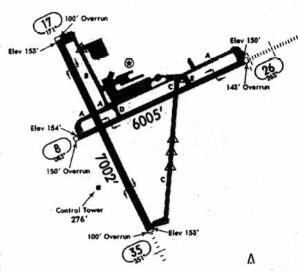
The 1994 Jeppesen Airport Directory depicted NAS South Weymouth as having 2 paved runways (7,002' Runway 17/35 & 6,005' Runway 8/26),
as well as numerous taxiways & ramps.
The Base Realignment & Closure Commission of 1995 recommended that NAS South Weymouth be closed,
but it would be 2 more years before the recommendation was implemented.
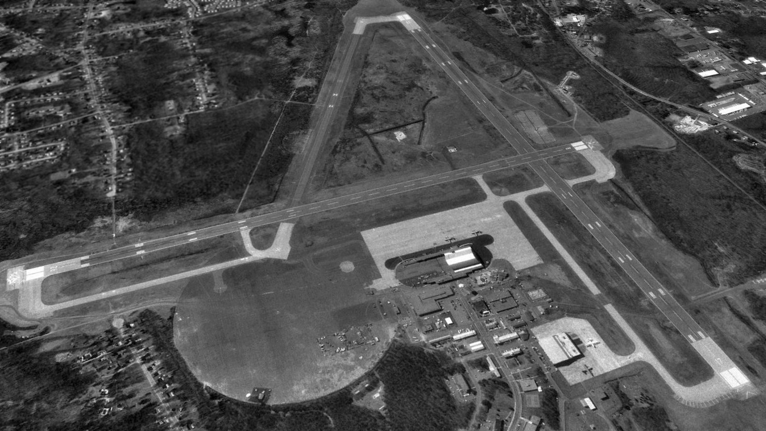
A 4/2/95 USGS aerial view looking south depicted only 4 aircraft on South Weymouth's expansive ramps: 2 C-130s & 2 P-3s.
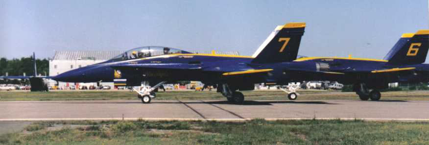
A 1996 picture by Christopher Gatto of an F/A-18B & F/A-18A of the Navy's Blue Angels taxiing at South Weymouth's last airshow.
The Blue Angel's C-130 “Fat Albert” is visible in the left background.
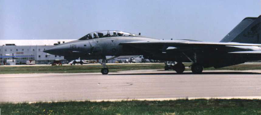
The last photo which has been located of an aircraft operating at South Weymouth
was a 1996 picture by Christopher Gatto of an F-14 Tomcat taxiing at South Weymouth's last airshow.
A South Weymouth hangar is visible in the left background.
Rob Durso passed along the description of why South Weymouth had 2 control towers almost on top of each other:
"A few months before the base received its closure notice, they had decided to install a new tower.
The contract went out to bid & it was awarded right before the closure announcement.
Since the contract was already signed, they didn't want the contractor to take the money & run - the Navy wanted the work done.
The tower was never outfitted; it's completely empty!"
Increasingly surrounded by development of the expanding Boston suburbs, South Weymouth closed on 9/30/97.
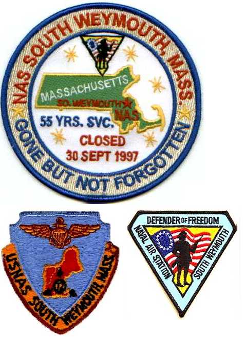
A patch (courtesy of Christopher Gatto) of a patch commemorating the 9/30/97 closure of NAS South Weymouth,
along with 2 other South Weymouth patches.
The local government intended to redevelop South Weymouth, with no intention to keep the aviation facilities.
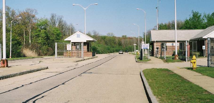
A March 2003 photo by Ron Plante of the former entrance gate of NAS South Weymouth.
Ron reported, “The main gate is wide open & its buildings are intact.”
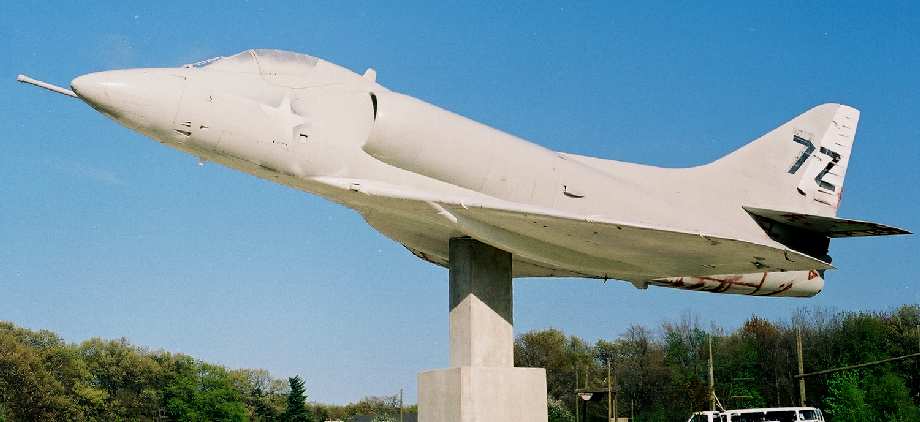
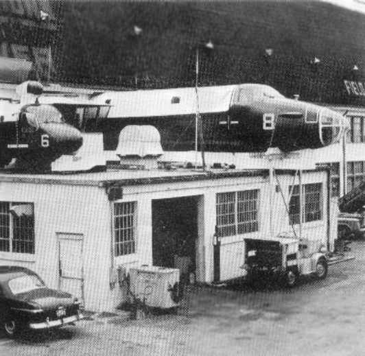
A 2003 photo by Ron Plante of an A-4 Skyhawk mounted on a pylon South Weymouth.
"Less than a mile past the gate is a display A-4 covered with looks like a base coat of paint.
The only visible lettering is a large '7Z' on the tail
(Mel Shettle’s 'US Naval Air Stations of WWII, Vol I, Eastern States' has a 1993 photo with all the markings).
Next to the A-4 are some benches & memorials.
One plaque states that the name Shea Field was transferred from Squantum to South Weymouth."
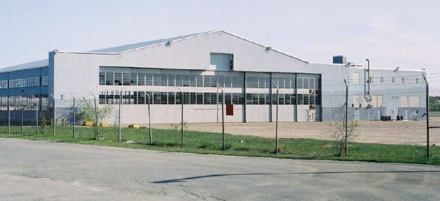
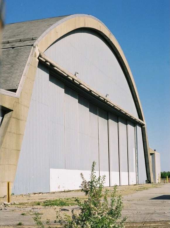
A 2003 photo by Ron Plante of an abandoned hangar on the northwest side of the South Weymouth ramp.
Ron reported, “The flight line/hangar area is surrounded by a chain link fence, and the hangars look good.
The blimp hangar door tracks can be seen in 2 of my photos in front of the concrete hangar [which was built on the site of the blimp hangar].
The remainder of the station is in pretty good shape, with no signs of vandalism.
Some of the family housing is used by the Coast Guard.
Although there are plans for extensive redevelopment, none was visible when I visited.
The station still has that spooky look of a functioning air base missing only aircraft & personnel."
A 2003 photo by Ron Plante of another abandoned hangar at South Weymouth.
A 2003 photo by Ron Plante of the strange sight of South Weymouth's 2 control towers,
right next to each other (one of which was built & never used).
Rob Durso reported in 2004 of the airfield's redevelopment plans,
"Things are such a mess there right now that it will probably be several more years before a shovel hits the ground there."
An article in the 2/3/05 issue of the Wall Street Journal reported that General Motors had set up an automobile test course on the South Weymouth runways,
giving invited potential customers the chance to drive new cars in GM's lineup.
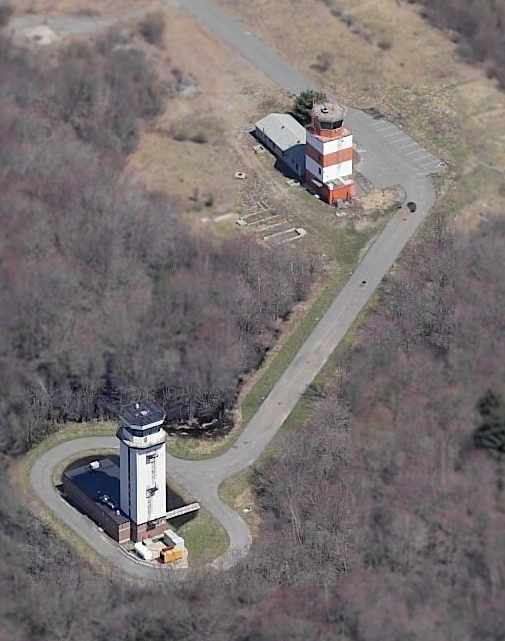
An odd sight- a circa 2005 aerial photo looking north at the 2 unused control towers at South Weymouth.
Couldn't these structures be relocated to airports that could use a control tower?
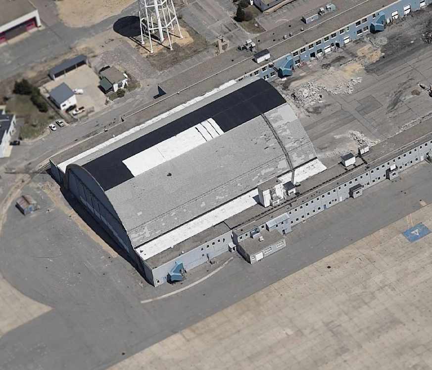
A circa 2005 aerial photo looking north at the concrete arch-roof hangar which was built over the site of South Weymouth's blimp hangar.
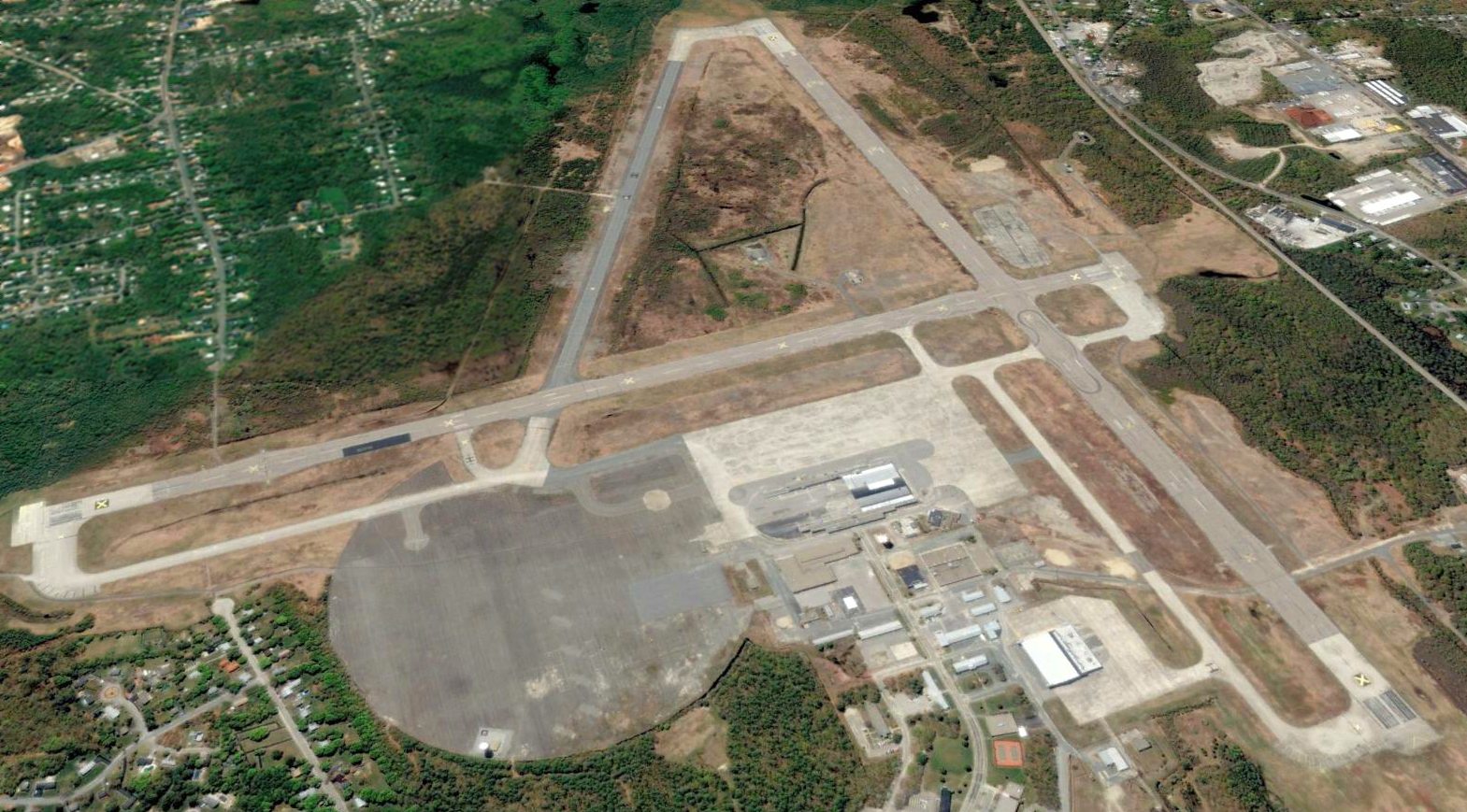
A 2005 aerial view looking south at South Weymouth, showing the field remaining intact.
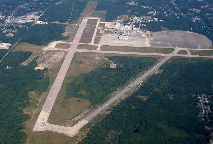
A July 2005 aerial view by Suresh Atapattu looking north at the abandoned South Weymouth airfield.
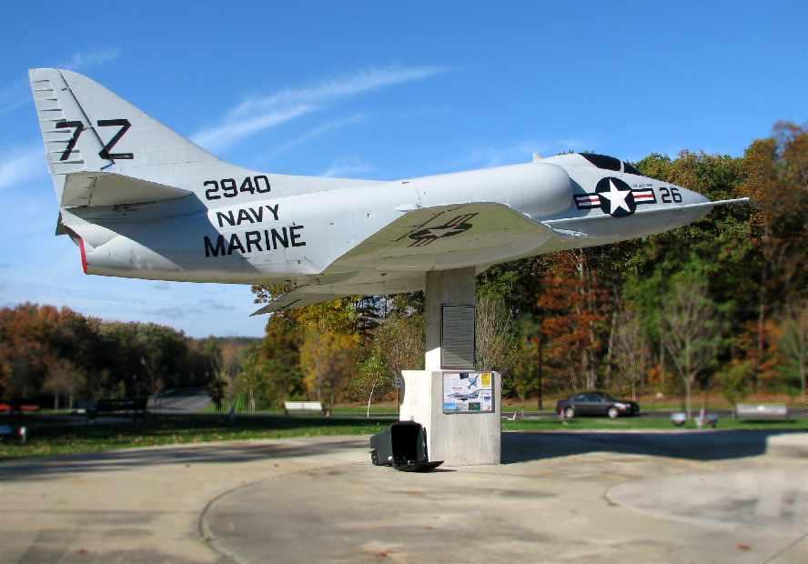
A 2007 photo by Steve Cohn of the “Renovated memorial to the Naval Air Station.
The A-4 Skyhawk has been carefully restored
and a vary tasteful permanent memorial constructed in memory of all those who have served who were stationed at NAS South Weymouth.”
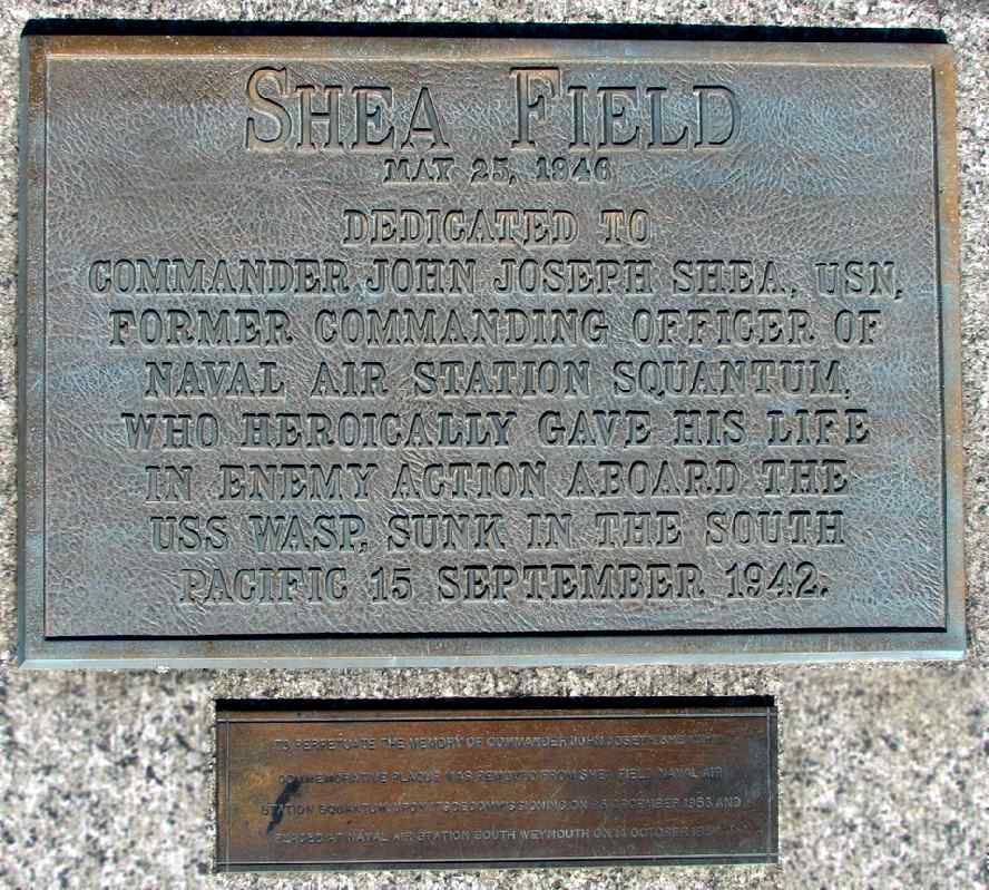
A 2007 photo by Steve Cohn of the plaque at the memorial, describing the naming of the field as Shea Field.
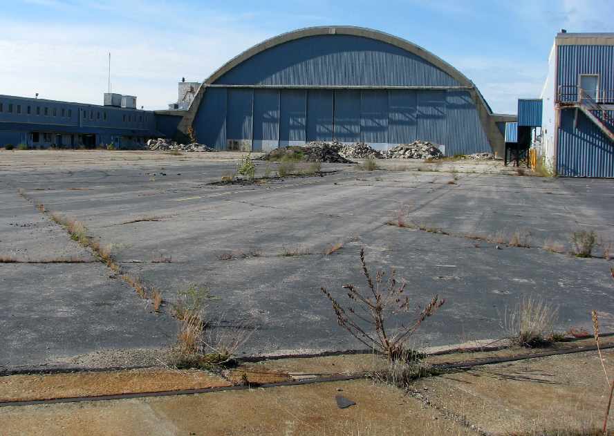
A 2007 photo by Steve Cohn of the “Old Hangar #1 from the east through the fence.
Not much has changed since the last photo in 2003.”
Note the tracks for the former blimp hangar in the foreground.
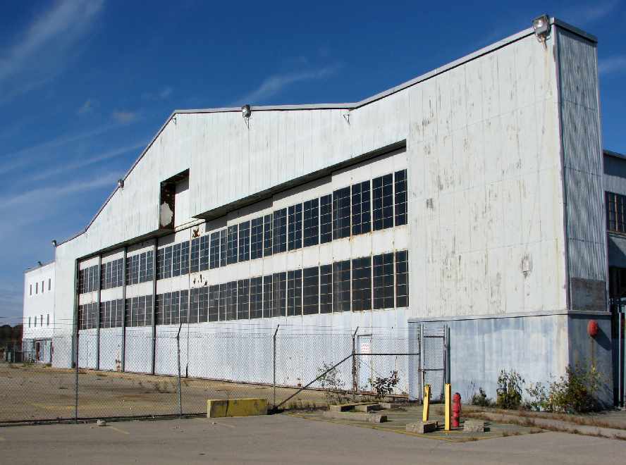
A 2007 photo by Steve Cohn of the former Hangar #2, the “Old Marine hangar, last used for the C-130 squadron VR-62,
before their transfer to NAS Brunswick, ME.
Steve reported that there were “more than 100 construction vehicles on site.
So far, construction is taking place away from the former flightline & former buildings.
But in time they too will be demolished & replaced with a mix of residential & commercial space.”
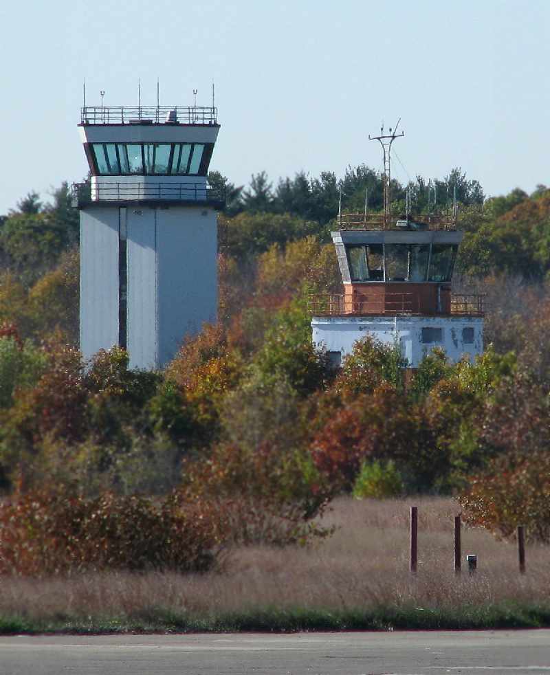
A 2007 photo by Steve Cohn of the odd sight of South Weymouth's 2 control towers: new & old.
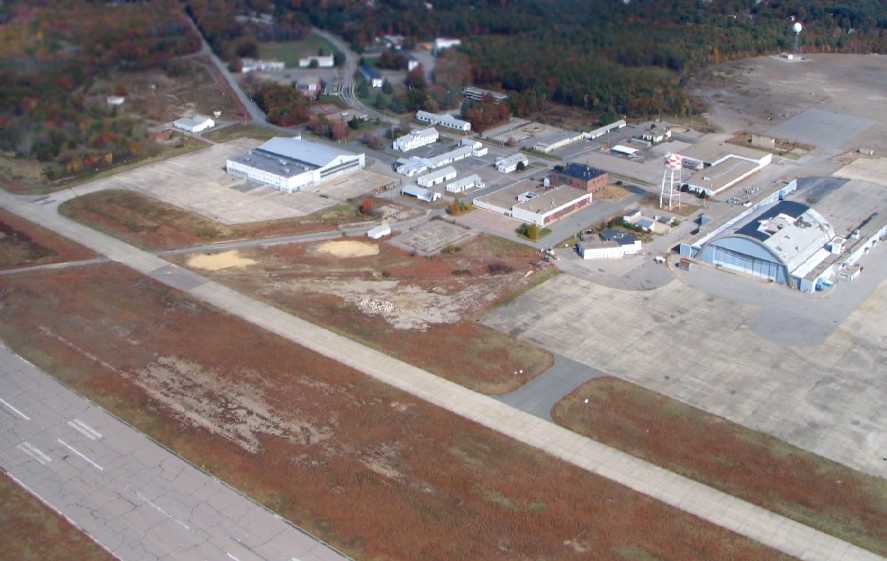
A 2008 aerial view by Steve Rose looking northeast at South Weymouth's hangars.
According to Steve, the base is “soon to be demolished & changed into a possible movie-making set.”
Nearby resident John Bandzul reported in 2008, “There is not going to be a movie studio up there after all.
LNR has bought just about 550 acres & the rest is still owned by the Navy.
There is an agreement within the next year to transfer the rest of the land to the tri-town corporation
and they have an exclusive contract to sell the rest of the land to LNR.
The 10 year development plan is to start the roll-out in 2009 with about 55 housing units
and the whole project (which includes housing, bike paths, shopping center, and golf course)
is expected to take about 12 years to complete at a total unknown price tag.
Boston Approach is using it a VFR holding point at this time.
The runways' removal has already begun & will be completed in the next 18 months.”
Jay Epstein reported in 2008, “Today I took an advanced driving course at the old South Weymouth NAS.
My Dad & I drove through the old base and past many abandoned, mysterious buildings
and up to a gate located off to the left of location of the blimp hangar
to wait for one of the employees of the driving school (In Control it was called) to open it up.
It was kind of spooky just sitting there waiting in silence, looking at all the abandoned buildings & overgrown tarmac.
If you closed your eyes you could almost hear the roar of fighter jets long since departed.
After a while one of the guys came and let me & about 7 cars in the gate.
We followed the employee over to a taxiway that connected to the former Runway 8/26.
There we did all sorts of fun emergency maneuvers on Runway 8/26.
It was very cool driving around on the old, overgrown runway.
Most of the buildings seemed to be in decent condition despite their age & probable lack of maintenance.
Though one of the driving instructors told us that the fire-suppression system
went off in one of the old buildings so now it's covered in foam.
He also said that they weren't allowed to have running water due to all the old nasty stuff in the ground.
Also, they've redone the whole entrance, making it look quite nice
The gate complex is now completely gone.
None of the planned construction/remodeling of the base seems to be going on though.”
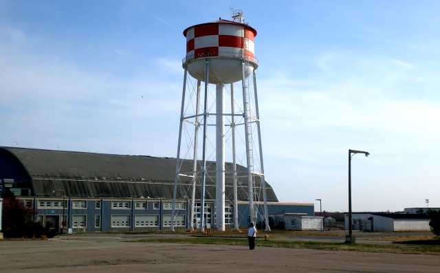
An April 2008 photo by Chris Gatto of the South Weymouth water tower with a hangar in the background.
As of September 2011, the former Hangars #1 & #2 remained standing,
although condos were being built adjacent to the former South Weymouth runways.
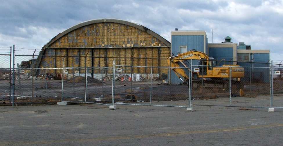
What an awful sight for anyone who appreciates our nation's aviation heritage:
A February 2012 photo by Bill Sargent (of the Weymouth Historical Society / ANA Patriot Squadron),
“looking west from the east mat landing area)”, of “the start of the demolition of ( HTA) Hangar One at South Weymouth.
The south lean-to is 85% demolished as of 2/24/12.”
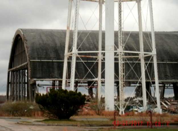
A 3/31/12 photo by Clyde Ramsdell showing Hangar 1 in the process of being demolished.
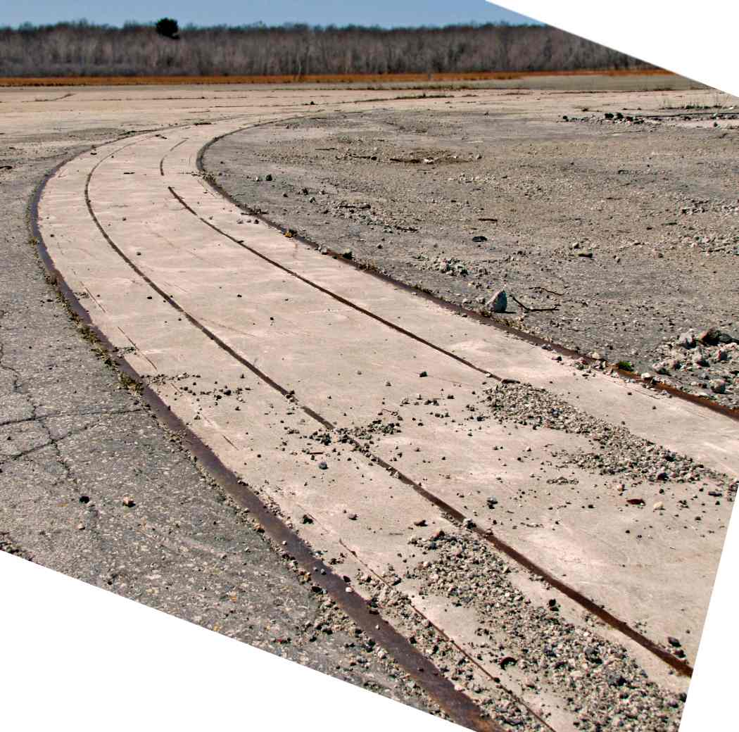
A 4/5/13 photo by Marc Senger of the curved hangar door tracks that remain from South Weymouth's massive Hangar 1.
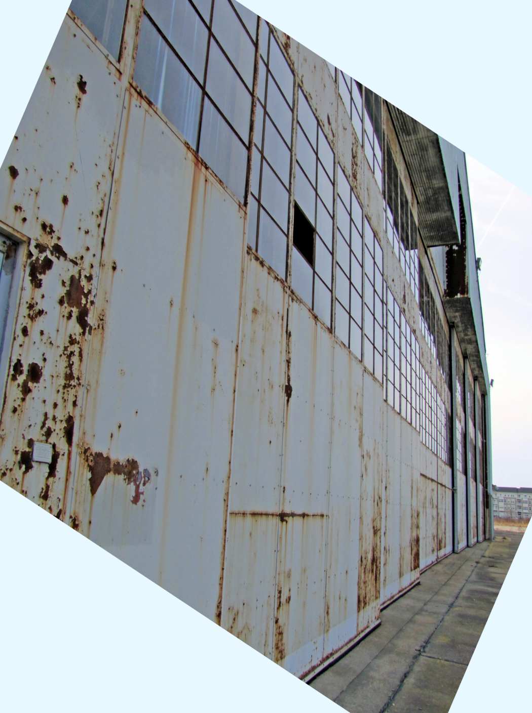
A 4/5/13 photo by Marc Senger of South Weymouth's former Hangar #2.
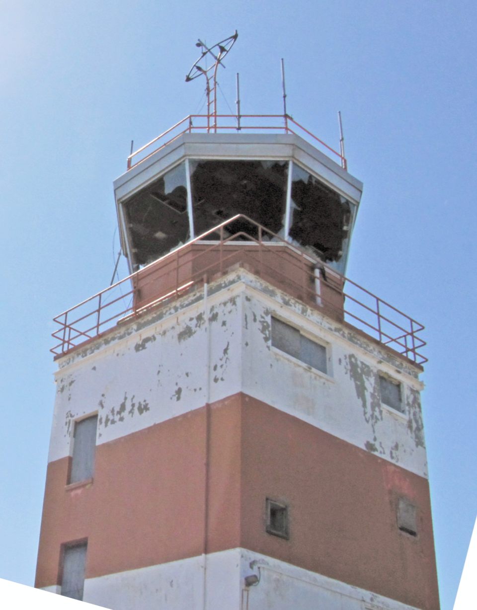
A 4/5/13 photo by Marc Senger of the older of South Weymouth's 2 control towers.
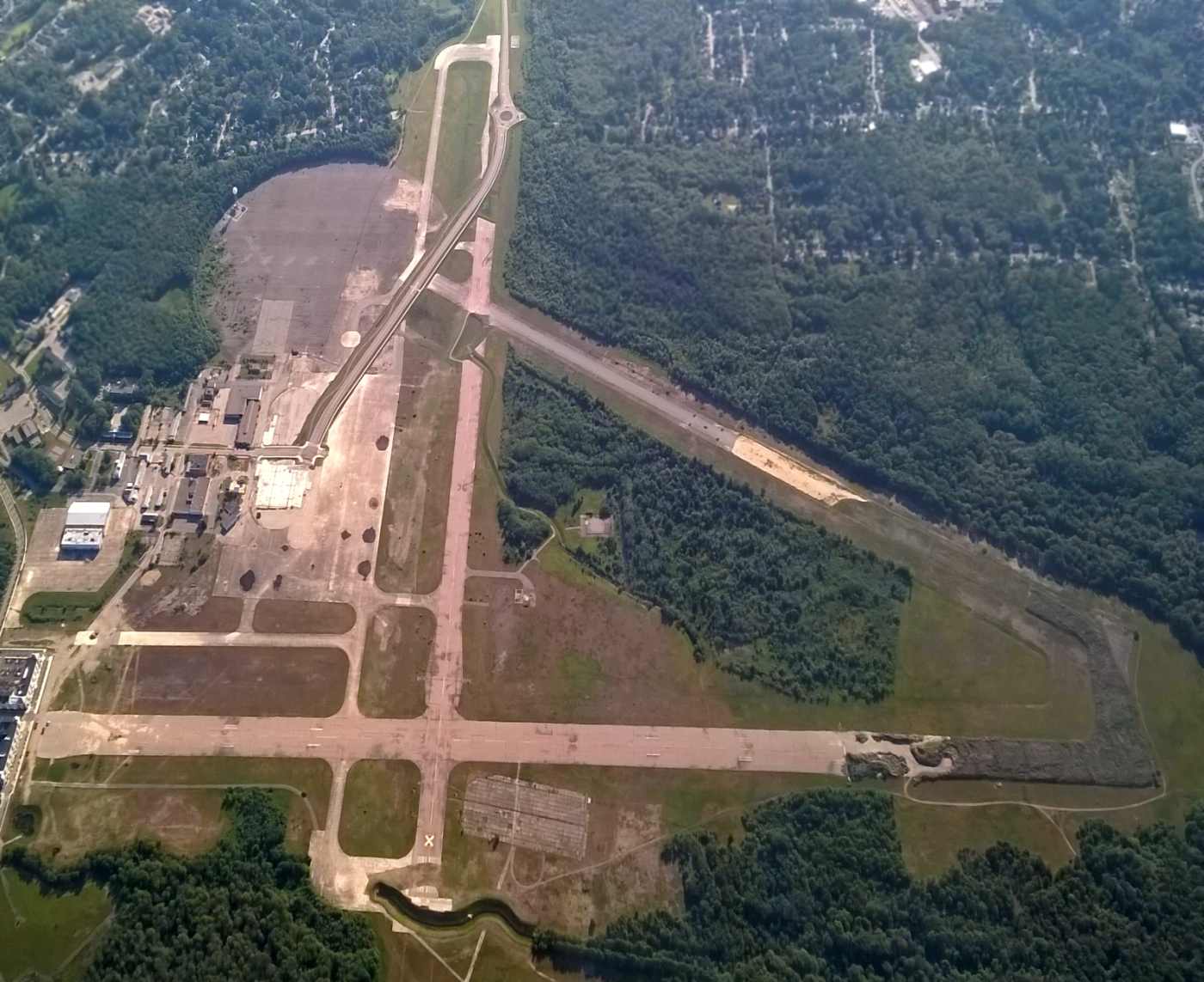
A sad 6/10/15 aerial view by Graeme Smith looking east at the remains of NAS South Weymouth, showing the newly-built road cutting wastefully across the runway & ramp.
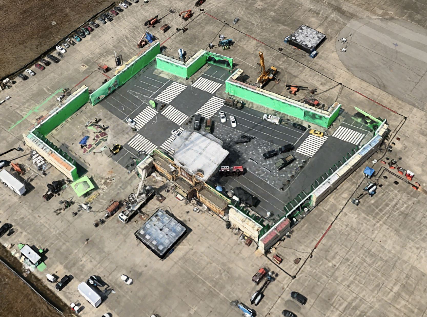
A circa 2015 aerial view (courtesy of Jake Moon) of a movie set constructed on the NAS South Weymouth ramp.
Jake Moon reported, “NAS Weymouth has been used for the filming of several movies, and a city intersection set can be seen on the apron.
It contains an overturned fire truck, military trucks, and several police cars. This is from the 2016 remake of Ghostbusters.”
A February 2016 photo annotated by Graeme Smith of the movie set constructed on the NAS South Weymouth property for the movie “Patriots Day”.
Graeme observed, “It was originally envisaged that after the airfield closed, a movie & sound stage complex would be built. It never happened.
But... The 'finish line' set was created on the airfield using 50 carpenters & about 20 painters.
1. All of the banners & graphics were printed to match the style of the 2013 marathon.
2. Duffield meticulously mapped out the location of granite tiles, bricks, and even notable gum spots while re-creating Boylston Street.
3. Extras were given yellow jackets to match those worn by officials at the 2013 marathon.
4. Boston Marathon organizer Eddie Jacobs had his crew break down the actual finish line the minute the 2016 race was over
so the filmmakers could use the real bleachers, grandstands, photo bridge, and other pieces for the movie.
5. New Hampshire–based AMI Graphics made a replica vinyl transfer of the finish line for the film.
6. The international flags featured on the photo bridge, a staging area for the press by the finish line, were the same ones that were flying when the bombs exploded.
7. To re-create the brick LensCrafters building, now an AT&T store, the crew built the upper story to match how it looked three & a half years ago.
The interior was also replicated, including the displays of lenses & frames.”
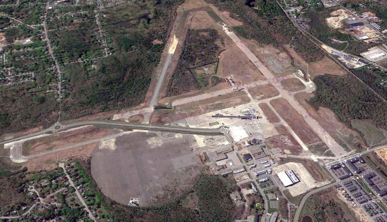
A 2016 aerial view looking south at the remains of NAS South Weymouth, showing development encroaching on the former airfield.
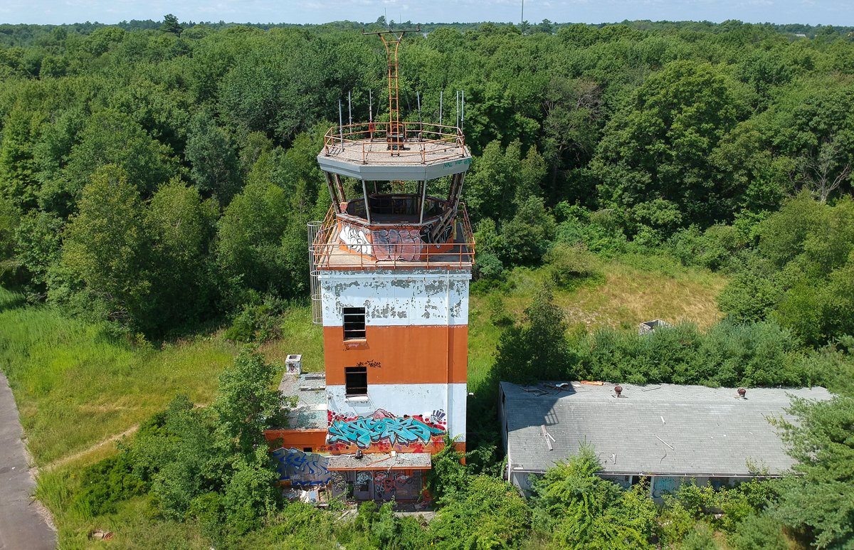
A 7/15/18 photo of the older of South Weymouth's 2 control towers.
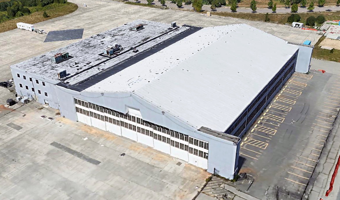
A 2019 3-D depiction looking northwest at the only remaining hangar at South Weymouth, Hangar #2.
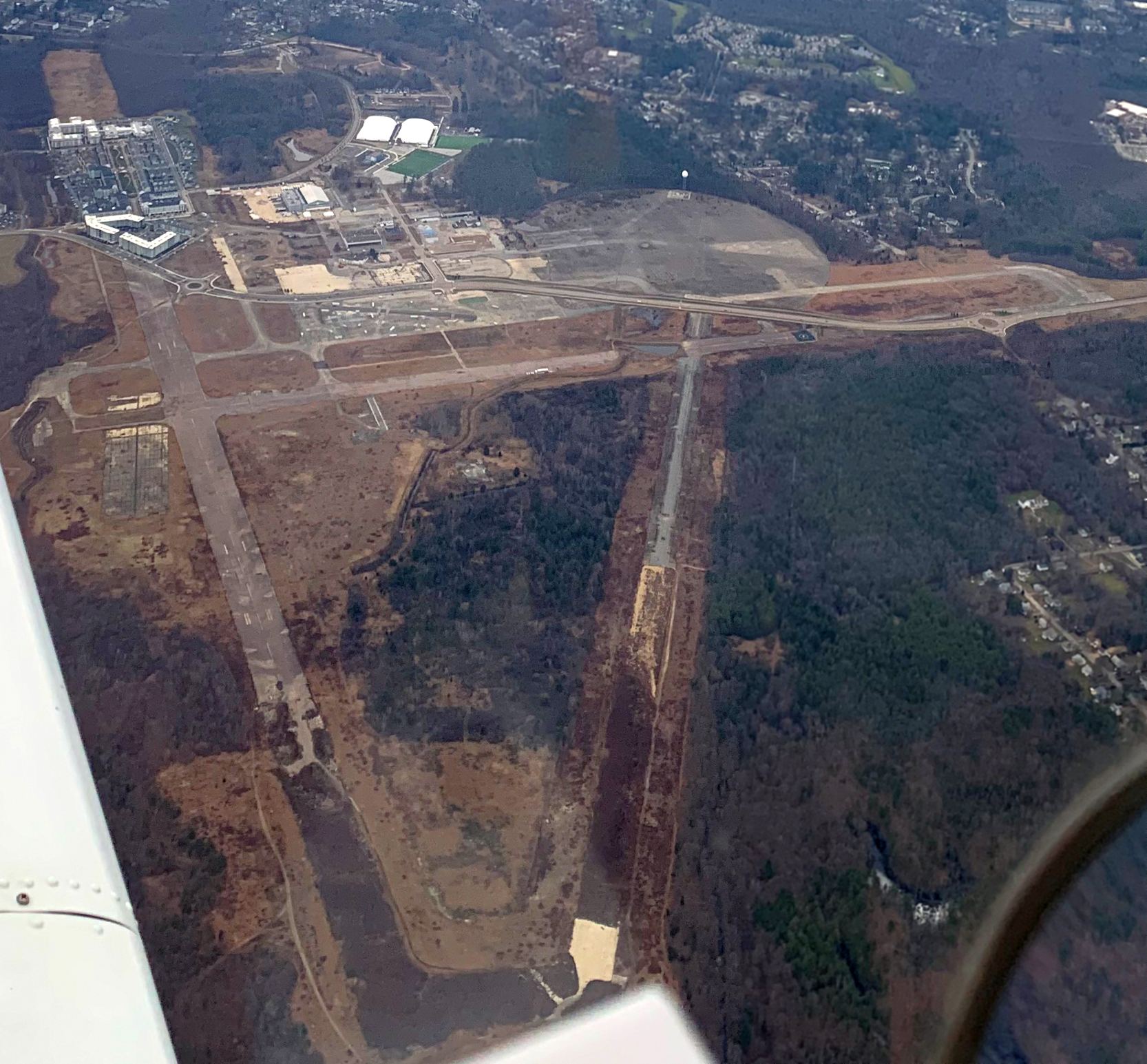
A 12/31/20 aerial view by Rocky Breslow looking north at the remains of NAS South Weymouth.
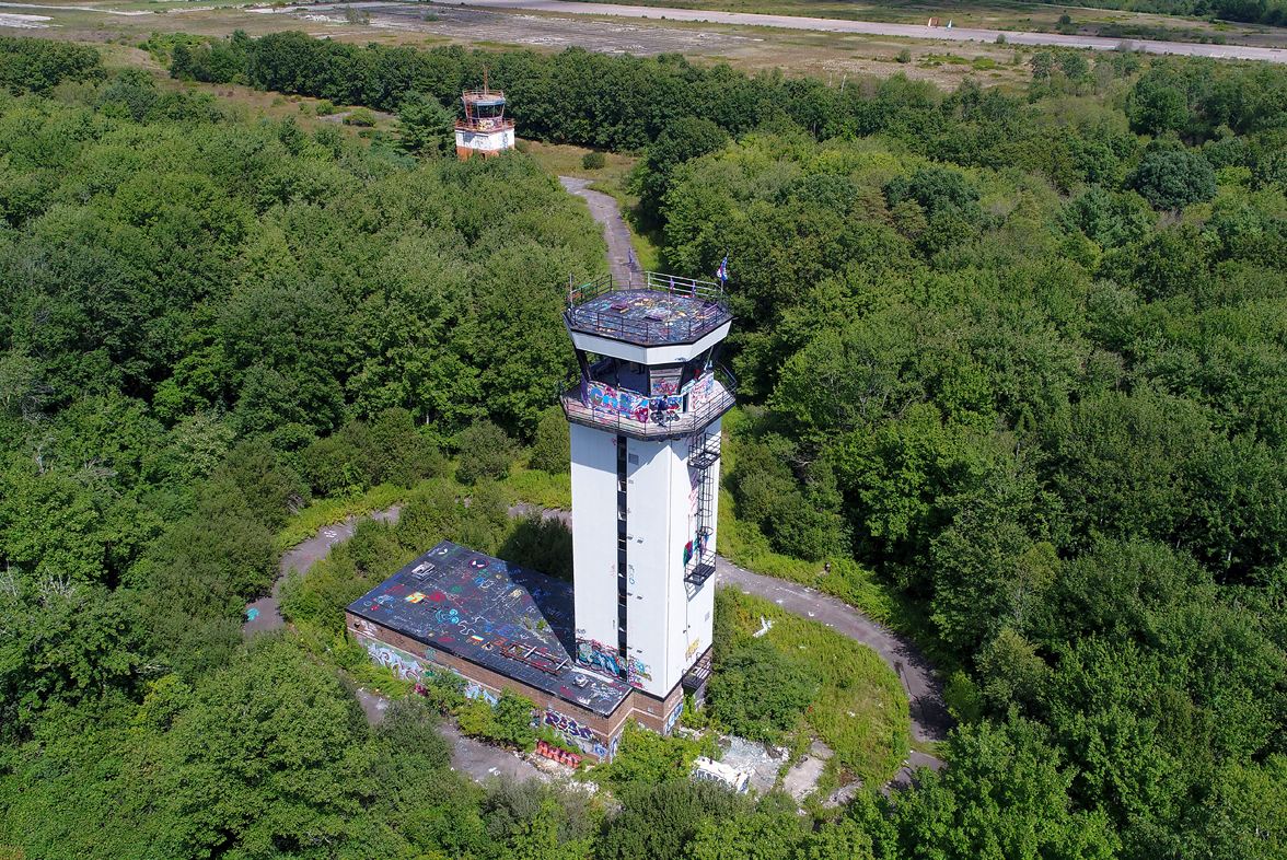
An 8/30/20 drone aerial view by John Jauchler of South Weymouth's 2 control towers.
See also: http://www.vpnavy.com/nassw.html
____________________________________________________
Since this site was first put on the web in 1999, its popularity has grown tremendously.
If the total quantity of material on this site is to continue to grow,
it will require ever-increasing funding to pay its expenses.
Therefore, I request financial contributions from site visitors,
to help defray the increasing costs of the site
and ensure that it continues to be available & to grow.
What would you pay for a good aviation magazine, or a good aviation book?
Please consider a donation of an equivalent amount, at the least.
This site is not supported by commercial advertising –
it is purely supported by donations.
If you enjoy the site, and would like to make a financial contribution,
you
may use a credit card via
![]() :
:
Please consider checking the box to make a monthly donatation.
For a mailing address to send a check, please contact me at: paulandterryfreeman@gmail.com
If you enjoy this web site, please support it with a financial contribution.
please contact me at: paulandterryfreeman@gmail.com
If you enjoy this web site, please support it with a financial contribution.
____________________________________________________
This site covers airfields in all 50 states.