Abandoned & Little-Known Airfields:
Central Kentucky
© 2003, © 2024 by Paul Freeman. Revised 7/5/24.
This site covers airfields in all 50 states: Click here for the site's main menu.
____________________________________________________
Please consider a financial contribution to support the continued growth & operation of this site.
Codell Field / Histle Field (revised 11/5/21) - Creech AAF (revised 6/10/20) - Halley Field / (Original) Lexington Airport (added 12/8/22)
Lackey Airport / Berea-Richmond Airport (revised 11/5/21) - Lexington Airport (2nd location) / Glengarry Field / Cool Meadow Airport (revised 11/27/23)
(Original) Marshall Field (revised 9/9/19) - Mt. Washington Airport (added 12/11/22) - Port Richmond Airfield (added 5/20/22) - Smiths Grove Intermediate Field (added 2/12/23)
Spring Creek Airport / Dale Hollow Regional Airport / Petro Field (revised 7/5/24) - Thorn Hill Airfield (revised 7/1/18) - Warsaw Airport (added 9/25/20) - Williamsburg Cumberland Falls Airport (revised 9/9/19)
____________________________________________________
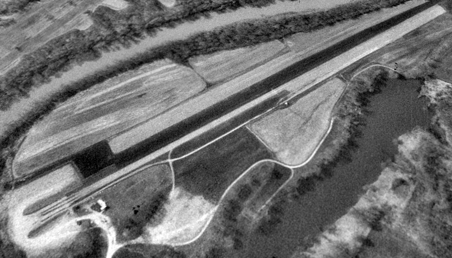
Smiths Grove Intermediate Field, Smiths Grove, KY
37.068, -86.191 (Southwest of Louisville, KY)
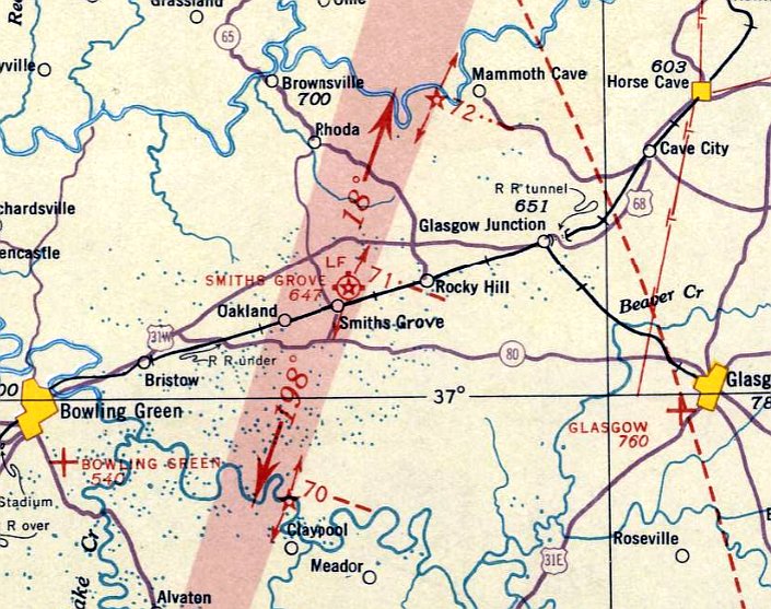
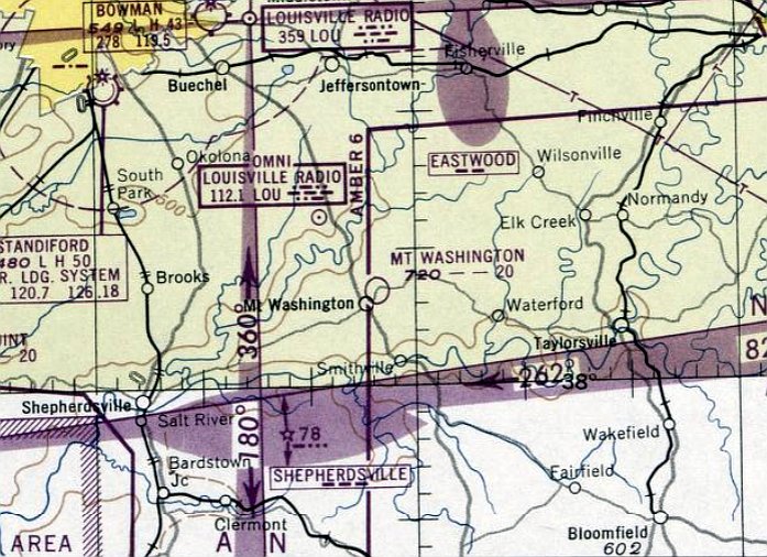
Smiths Grove Intermediate Field, as depicted on the September 1935 Nashville Sectional Chart.
The date of establishment of the Smiths Grove Airfield has not been determined.
The earliest reference which has been located of the Smiths Grove Airfield was a 6/11/26 Park City Daily News article (courtesy of Jim Burnett),
which mentioned that Smiths Grove had a field where planes could land.
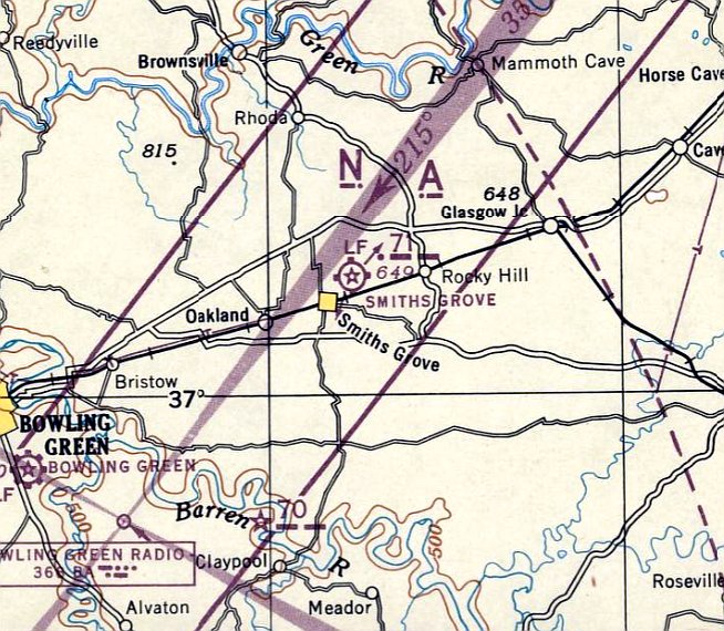
In 1931 the primitive Smiths Grove Airfield was improved by the Commerce Department into their Site 71,
one of their network of Intermediate Fields built for emergency use of commercial aircraft along airways between major cities.
The earliest directory listing which has been located of Smiths Grove Intermediate Field was on the 1931 Commerce Department Airway Bulletin.
It described Smiths Grove Intermediate Field as Site 71 along the Dallas-Louisville Airway, located 1 mile northeast of the town of Smiths Grove.
It was said to consist of a 94 acre L-shaped sod field, having 2 runways measuring 2,800' north/south & 1,879' east/west.
A Bowling Green newspaper article (courtesy of Jim Burnett) reported that a 5/4/32 receipt
was issued for guarding an aircraft at Smiths Grove on the occasion of W.G. McAdoo's visit.
The earliest aeronautical chart depiction which has been located of Smiths Grove Intermediate Field was on the September 1935 Nashville Sectional Chart.
It depicted Smiths Grove as a commercial/municipal airport, Site 71 along the airway.
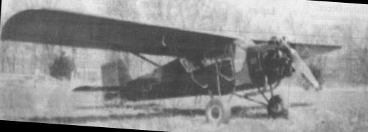
The only photo which has been located of Smiths Grove Intermediate Field was a circa 1930s photo of a 2-seat Curtiss Robin owned by Jess Kirby of Smiths Grove.
According to Smiths Grove resident Joe Jordan, Kirby stored his plane at the local feed mill, and flew it all over the county, taking Jordan's mother up for a ride.
A Bowling Green newspaper article (courtesy of Jim Burnett) reported that Smiths Grove resident Gerard Brown
recalled more than 100 aviators landing at Smiths Grove while enroute to an aviation exhibition.
Smiths Grove Intermediate Field was not depicted on USGS topo maps from 1937/42/44/48/56.
A 12/3/06 Daily News article (courtesy of Jim Burnett) reported that the Smiths Grove beacon moved to Bowling Green in 1944,
reportedly ending the field's use, but other later indications show it contained to remain in use.
The last aeronautical chart depiction which has been located of Smiths Grove Intermediate Field was on the March 1945 Nashville Sectional Chart.
It depicted Smiths Grove as a commercial/municipal airport, Site 71 along the Dallas-Louisville Airway.
Smiths Grove Intermediate Field was evidently closed at some point in 1945,
as it was no longer depicted on the October 1945 Nashville Sectional Chart.
Smiths Grove Intermediate Field was no longer depicted on subsequent Nashville Sectional Charts from 1946/48/50/51/52/53/55/60.
A Bowling Green newspaper article (courtesy of Jim Burnett) reported that Smiths Grove resident Joe Jordan
recalled the Smiths Grove Airfield was briefly revived during the Korean War as an emergency landing site.
Jordan remembered a bright white beam there that filled the night sky.
The earliest aerial view which has been located of the presumed site of Smiths Grove Intermediate Field was a 1954 aerial view.
It depicted what appeared to be the outline of 2 former grass runways, oriented north/south & east/west,
matching the description of the field from the 1931 Airway Bulletin.
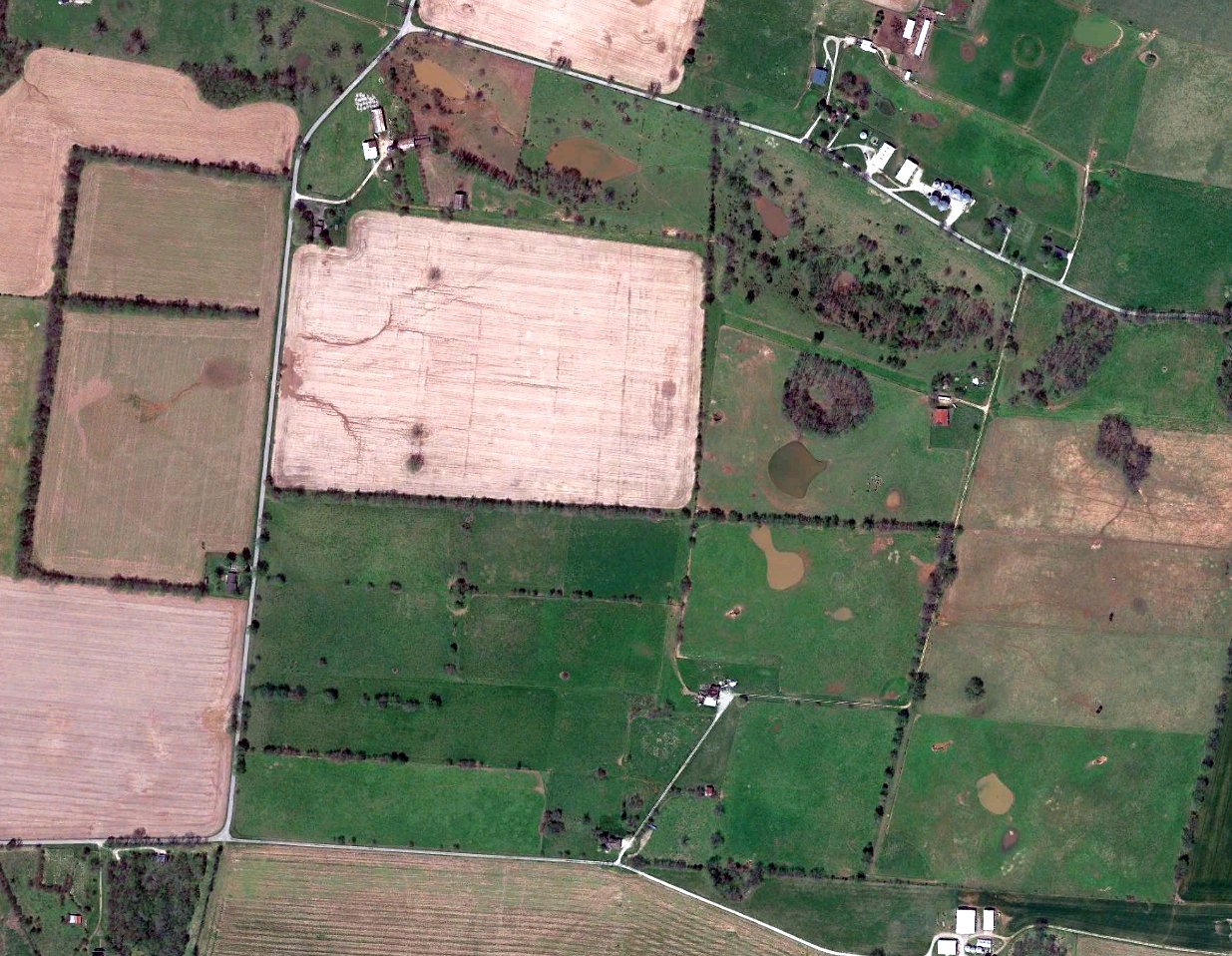
A 2022 aerial view shows no recognizable trace remaining of Smiths Grove Intermediate Field.
Thanks to Jim Burnett for pointing out this airfield.
____________________________________________________
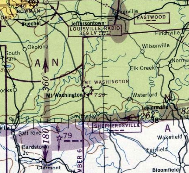
Mt. Washington Airport, Mt. Washington, KY
38.052, -85.54 (Southeast of Louisville, KY)
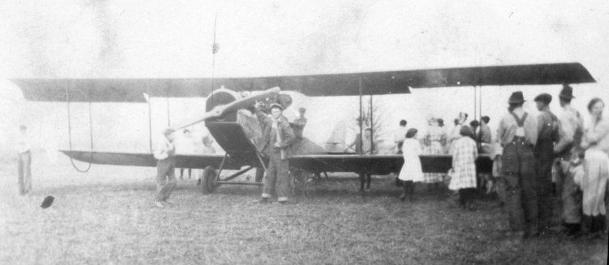
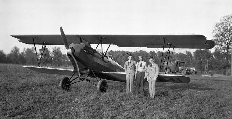
An undated photo of the first airplane in Mt. Washington, a Curtiss JN Jenny biplane.
According to the Bullitt County History Museum, “In Mt. Washington, there was an airport with a runway & a pretty substantial building.
Betty Couch remembers it as being centered about where the ValueMarket grocery store is today. Her father used to fly there when she was a child.
Gayle Troutman tells me that the field stretched from near Main Street to past the new Bardstown Road bypass.
There is a photo of a large old biplane there that was the first airplane to land at the airport.”'
The date of establishment of Mt. Washington Airport has not been determined.
It was not depicted on Cincinnati Sectional Charts from 1933/39/46.
The earliest aeronautical chart depiction which has been located of Mt. Washington Airport was on the April 1947 Cincinnati Sectional Chart.
It depicted Mt. Washington as a commercial/municipal airport.
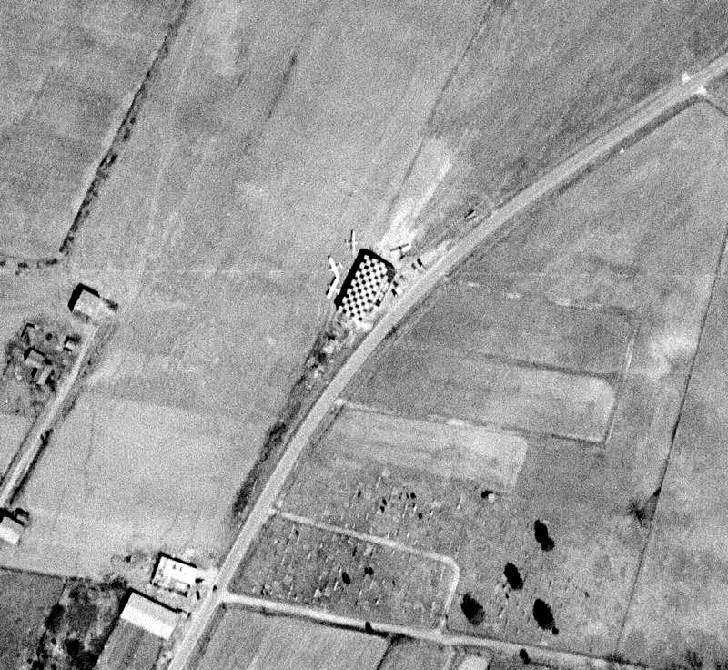
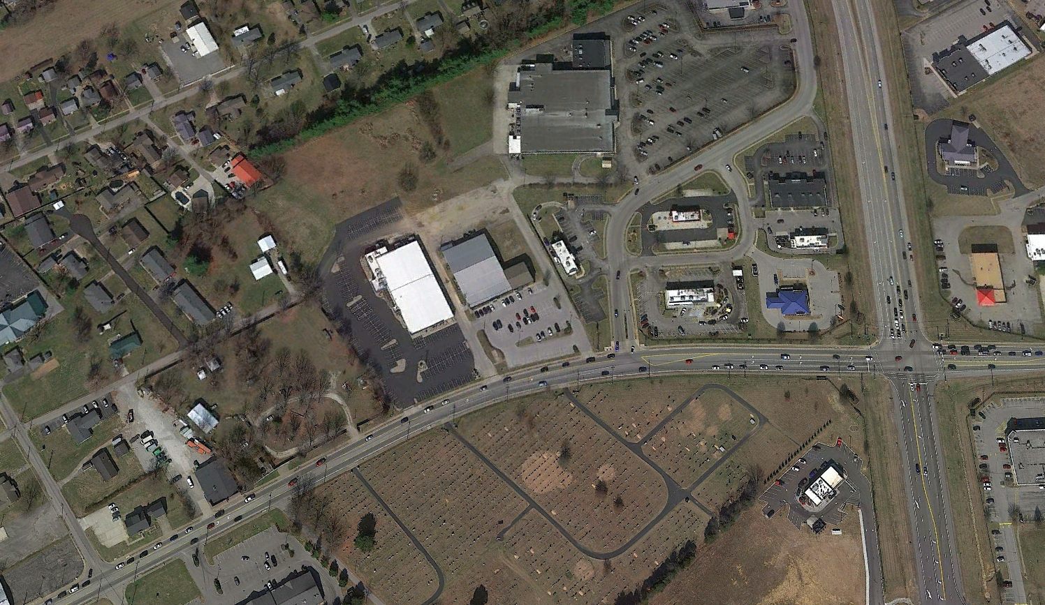
The only aerial photo which has been located of Mt. Washington Airport was a 1949 aerial view.
It depicted 4 light single-engine planes parked near a checkerboard-painted hangar on the east side of a northeast/southwest grass runway.
An undated photo of the Mt. Washington Airport building, and possibly 2 aircraft.
The last aeronautical chart depiction which has been located of Mt. Washington Airport was on the December 1949 Cincinnati Sectional Chart.
It depicted Mt. Washington Airport as having a 2,000' unpaved runway.
Mt. Washington Airport was evidently closed (for reasons unknown) at some point between 1949-50,
as it was no longer depicted on the June 1950 Cincinnati Sectional Chart.
The Mt. Washington Airport was not depicted on the 1951 USGS topo map.
A 1955 aerial view showed a road had been constructed across the southern end of the Mt. Washington Airport runway,
but the airport building remained intact.
The former Mt. Washington Airport building was destroyed in a 9/13/59 fire.
A 1983 aerial photo showed 2 retail buildings had been built over the Mt. Washington Airport site at some point between 1971-83.
A 2022 aerial view looking northwest showed no trace of Mt. Washington Airport.
Thanks to Eric Karnes for pointing out this airfield.
____________________________________________________
Halley Field / (Original) Lexington Airport, Lexington, KY
38.071, -84.525 (Northwest of Downtown Lexington, KY)

A March 1928 photo of Charles Lindbergh showing his visit to Halley Field.
According to ExploreKY.com, “Meadowthorpe was a well-known stock farm owned by Jacob Hostetter.
In 1906, it was acquired by Dr. Samuel Halley, president & general manager of Fayette Tobacco Warehouse.
The first airport serving Lexington opened in the summer of 1927, with World War I ace Ted Kincannon as manager.
Charles Lindbergh made arrangements with Kincannon to land there on 3/28/28, with the stipulation that his arrival be kept secret.
Seventeen-year-old Melvin Rhorer was recruited to mark the field for the landing & spend the night in the plane, while Lindbergh went to visit a friend, Scott Breckinridge.
The secret leaked out overnight & the next morning there were 3,000 people there to watch the plane take off.”
According to Eric Karnes, “Halley Field, Lexington's first airport, [was] on the north side of Leestown Pike (West Main Street) east of the New Circle Road interchange.
Lindbergh visited there on his round-the-country trip after the Paris flight & suggested Lexington build a better airport for future airline service.
Lindbergh was very unimpressed with Halley. He almost snagged a utility line on landing.
He embarrassed the Lexingtonians by comparing their airport to the excellent Bowman Field in Louisville, their cross-state (but much larger) rival.”
According to ExploreKY.com, “Halley Field was host to air circuses, air shows, flight training, sight-seeing tours, and small airlines.
Because it was only a level pasture surrounded by trees & telephone wires, it was a challenging place to land & take off.”
The earliest photo which has been located of Halley Field was a 1930 photo captioned “Air climbers of America”, showing 3 men in front of a Travel Air 2000 biplane.
The earliest aeronautical chart depiction which has been located of this airfield was on the March 1933 Cincinnati Sectional Chart.
It depicted “Lexington” as a commercial/municipal airport.
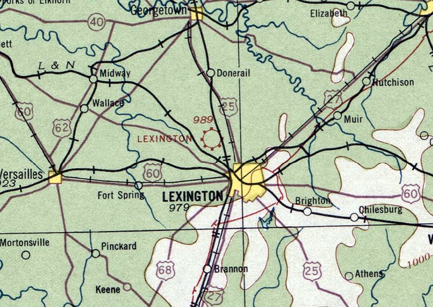
The last depiction which has been located of this airfield was on the June 1934 Cincinnati Sectional Chart.
It depicted “Lexington” as a commercial/municipal airport.
According to ExploreKY.com, “Halley Field was abandoned in 1934. It was later sold to H.R. Taylor & reverted back to farmland.”
The original Lexington Airport / Halley Field was no longer depicted on the April 1935 Cincinnati Sectional Chart,
which instead depicted the replacement Lexington Airport a few miles east, which been built on Newtown Pike.
Halley Field was no longer depicted on the 1940 USGS topo map.
According to ExploreKY.com, “Meadowthorpe Farm... began being sold for building lots in 1949.”
A 1949 aerial photo showed residential streets had begun to be constructed on the Halley Field site.
A 2019 aerial view looking north showed no trace of Halley Field.
According to ExploreKY.com, “Historical Marker #2440 in Fayette County commemorates Halley Field.”
The history of Halley Field is commemorated by the name of one of the residential streets on the site, Meadowthorpe Avenue.
Thanks to Eric Karnes for pointing out this airfield.
____________________________________________________
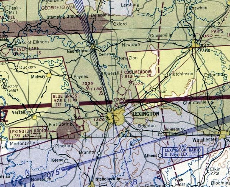
Lexington Airport (2nd location) / Glengarry Field / Cool Meadow Airport, Lexington, KY
38.11, -84.476 (Northeast of Downtown Lexington, KY)
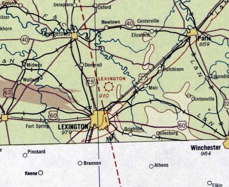
Lexington Airport, as depicted on the April 1935 Cincinnati Sectional Chart.
According to ExploreKYHistory.com, “With the development of larger multi-engine aircraft & the restrictions on runway lengths,
Halley Field quickly became obsolete, and a larger airport was needed.
In February 1930, the Airport Committee of the Board of Commerce leased the Glengarry Farm for a new, larger municipal airfield.
The farm was located on Newtown Pike, 5 miles from Lexington & owned by James Anderson.
It was built on the site of a Civil War Union Army encampment & skirmish.”
No airfield at this location was yet depicted on the June 1934 Cincinnati Sectional Chart.
The earliest aeronautical chart depiction which has been located of this airfield was on the April 1935 Cincinnati Sectional Chart.
It depicted “Lexington” as a commercial/municipal airport.
According to ExploreKYHistory.com, “Glengarry Field was dedicated on 7/12/35.
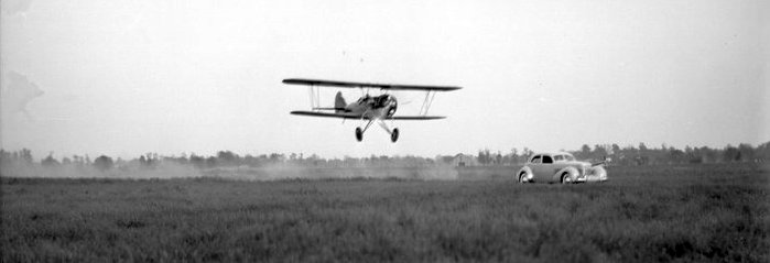
A 1936 photo showed a radial-engine Travel Air biplane overflying a car (which appears to be a 1936 Cord 810) at low altitude over a Glengarry Field flying circus.
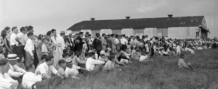
A crowd in front of a Glengarry Field hangar watching a 1936 flying circus.
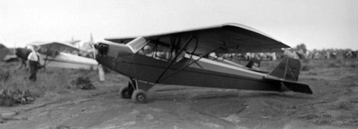
Two Piper Cubs seen at Glengarry Field during a 1936 flying circus.
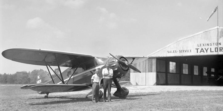
A 9/7/36 photo of 2 men in front of Waco YOC C/n 4271 NC14628 cabin biplane in front of a Glengarry Field hangar.
Glengarry Field was renamed Cool Meadow Airport by 1945,
as that is how it was labeled on the May 1945 Cincinnati Sectional Chart.
The only aerial view which has been located showing Cool Meadow Airport in operation was a 1949 aerial photo.
It showed Cool Meadow Airport as having 2 grass runways, with an airfield circle marking northwest of the runway intersection.
Six hangars were located along the north side, one of which had a checkerboard-painted roof, and 5 light single-engine planes were parked nearby.
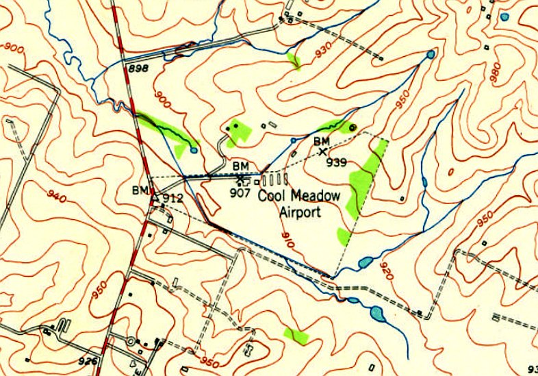
The only topo map depiction which has been located of Cool Meadow Airport was on the 1950 USGS topo map.
It depicted Cool Meadow Airport as an irregularly-shaped property outline, with 7 small buildings along the north side.
The last depiction which has been located of Cool Meadow Airport was on the June 1951 Cincinnati Sectional Chart.
It depicted Cool Meadow Airport as having a 2,500' unpaved runway.
According to ExploreKYHistory.com, “Cool Meadow Field operated until the mid-1950s, when Bluegrass Field was built on US 60.”
Cool Meadow Airport was evidently closed (for reasons unknown) at some point between 1951-52,
as it was no longer depicted on the January 1952 Cincinnati Sectional Chart.
The 1954 USGS topo map no longer labeled the airport or depicted its property outline, but the former hangars were still depicted.
A 1956 aerial view showed Cool Meadow Airport after its closure.
The 2 grass runways were still intact, though the northern portion of the northeast/southwest runway had been subdivided by agricultural fields,
and the airfield circle marking remained recognizable though deteriorated.
One of the hangars had been removed at some point between 1949-56, and no aircraft were visible.
A 1971 aerial view showed no change in the Cool Meadow Airport site.
According to ExploreKYHistory.com, “In Fasig-Tipton established its permanent Kentucky headquarters in Lexington”,
a large horse farm complex which covered the former Cool Meadow Airport.
A 1983 aerial view showed multiple horse farm buildings had been constructed at some point between 1971-83 over the Cool Meadow Airport site,
and all of the former hangars had been removed, erasing the last trace of the airport.
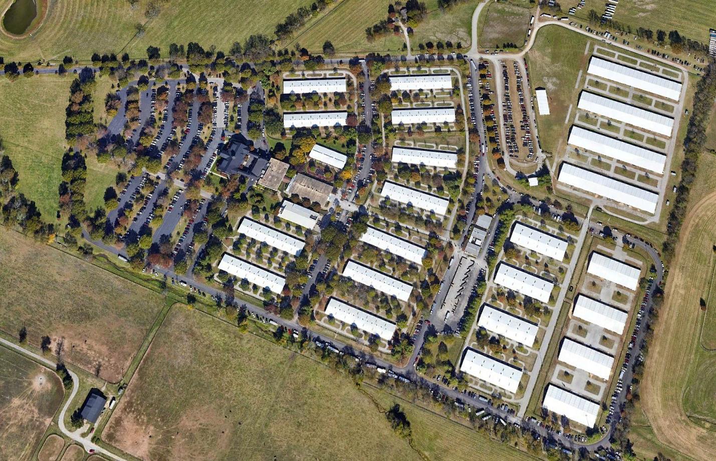
A 2019 aerial view looking north showed the only trace remaining of Cool Meadow Airport was the property outline.
Eric Karnes reported in 2022, “Cool Meadow Airport... [is] now occupied by the Fasig-Tipton horse farm & sales pavilion.”
According to ExploreKY.com, “Historical Marker #2439 in Fayette County commemorates Glengarry Field / Cool Meadow, the second airport in Lexington .”
Thanks to Eric Karnes for pointing out this airfield.
____________________________________________________
Port Richmond Airfield, Richmond, KY
37.747, -84.211 (Southeast of Lexington, KY)
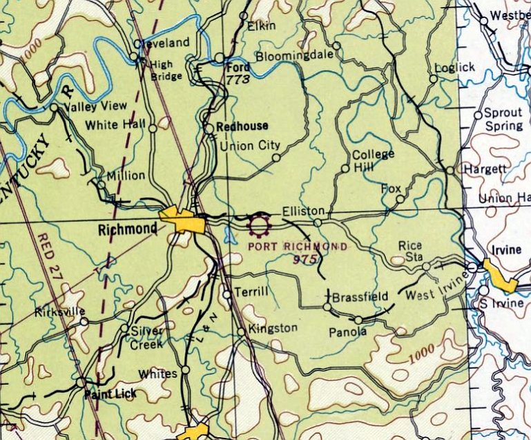
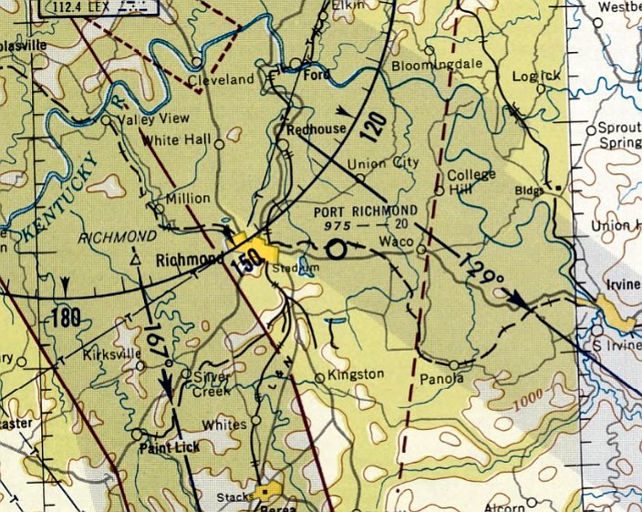
Port Richmond Airfield, as depicted on the April 1947 Nashville Sectional Chart.
This small general aviation airport was evidently established at some point between 1946-47,
as it was not yet depicted on the 1946 Nashville Sectional Chart.
The earliest depiction which has been located of Port Richmond Airfield was on the April 1947 Nashville Sectional Chart.
It depicted Port Richmond as a commercial/municipal airport.
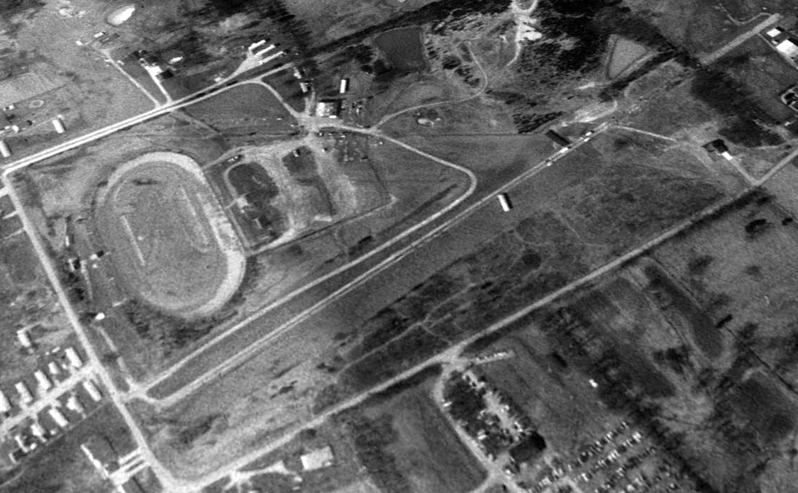
The earliest photo which has been located of Port Richmond Airfield was a 1950 aerial photo.
It depicted Port Richmond as having 2 unpaved runways in an “X” shape, with an airport circle marking at the intersection.
Two checkerboard-roofed hangars were located on the southwest side, but there were no aircraft visible on the field.
An oval racetrack was located adjacent to the southwest side, a facility which would eventually replace the small airport.
The last aeronautical chart depiction which has been located of Port Richmond Airfield was on the December 1955 Nashville Sectional Chart.
It depicted Port Richmond as having a mere 2,000' unpaved runway.
Port Richmond Airfield was evidently closed at some point between 1955-56,
as it was no longer depicted on the June 1956 Nashville Sectional Chart.
In a 1956 aerial photo, Port Richmond Airfield was evidently closed,
as the 2 hangars had been removed at some point between 1950-56.
The runways remained intact, but there was no sign of any recent aviation use.
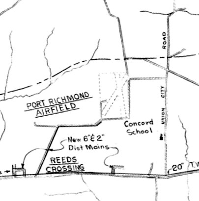
A 1962 Site Plan (courtesy of James Roberts) depicted Port Richmond Airfield as having 2 unpaved runways in an “X” shape.
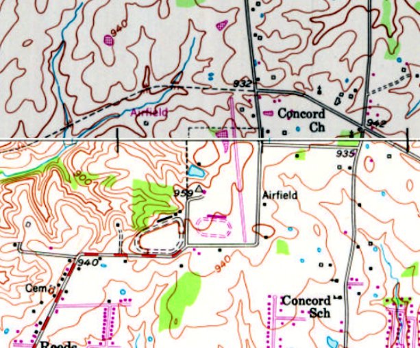
The earliest topo map depiction which has been located of Port Richmond Airfield was on the 1982 USGS topo map.
It depicted the previous 2 unpaved runways having been replaced by an oval racetrack (adjacent to the earlier oval racetrack to the west),
and a single paved northwest/southeast runway had been constructed to the east, generically labeled as “Airfield”.
But given that no airport was depicted at this location on aeronautical charts from this era, perhaps this was an error on the part of the mapmakers,
and what was presumed to be a runway was actually a dragstrip constructed for the racetrack which occupied the property by that time.
A 1983 aerial photo showed the racetrack covering the location of the former 2 unpaved runways,
and the northwest/southeast paved feature which could have been either a runway or a dragstrip.
There was no sign of any recent aviation use.
A 1997 aerial view looking northwest showed the racetrack covering the location of the former Port Richmond unpaved runways,
and the northwest/southeast paved feature which could have been either a runway or a dragstrip.
There was no sign of any recent aviation use.
The 2003 Cincinnati Sectional Chart did not depict any airfield at the Port Richmond location.
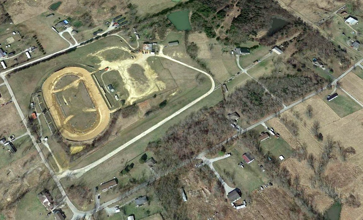
A 2021 aerial view looking northwest showed the racetrack covering the location of the former Port Richmond unpaved runways,
and the northwest/southeast paved feature which could have been either a runway or a dragstrip.
Thanks to James Roberts for pointing out this airfield.
____________________________________________________
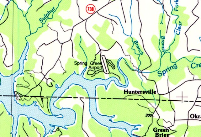
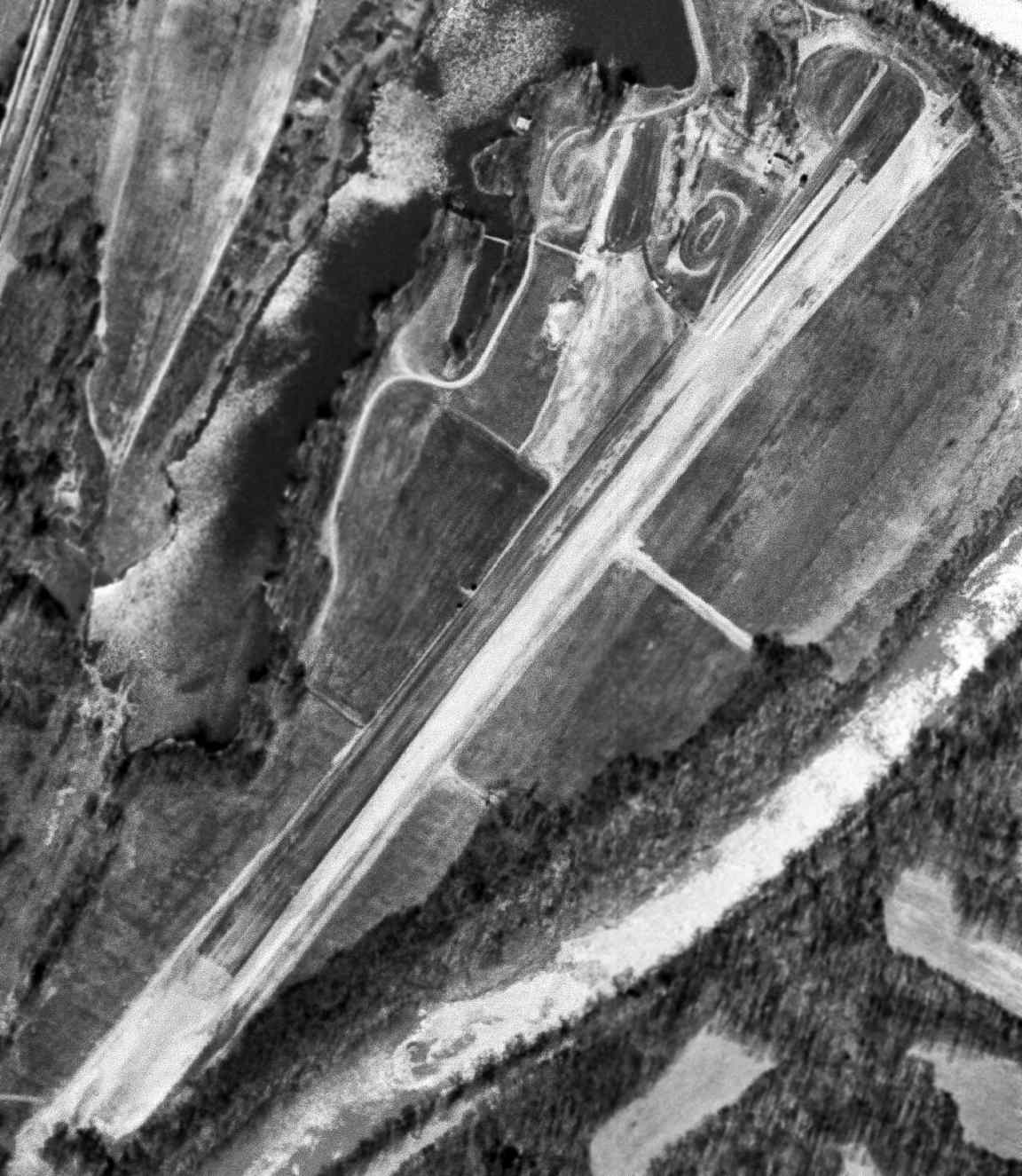
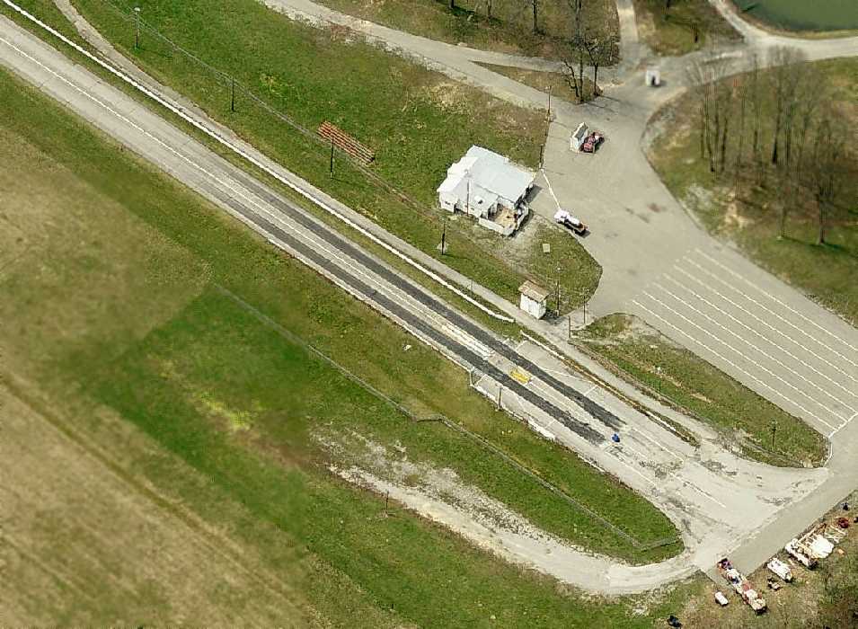
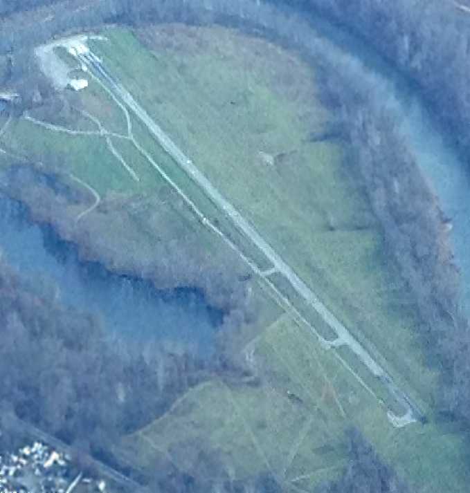
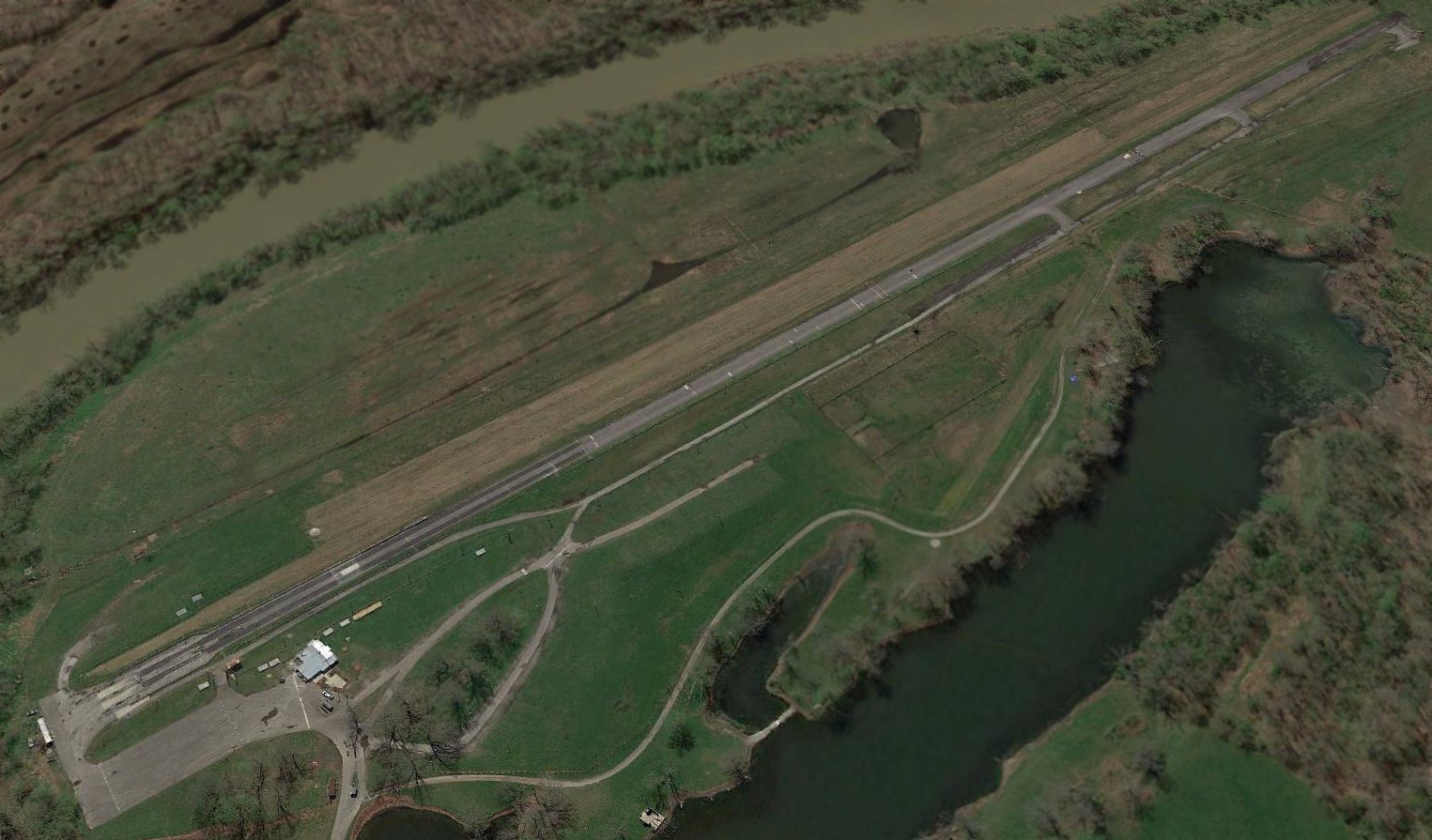
Spring Creek Airport / Dale Hollow Regional Airport / Petro Field (44I, 5KY7), Dale Hollow, KY
36.639, -85.164 (Southwest of Lexington, KY)
Spring Creek Airport, as depicted on the 1985 USGS topo map.
This small general aviation airport was evidently established at some point between 1960-81,
as it was not yet depicted on a 1960 aerial photo.
The earliest depiction which has been located of Spring Creek Airport was a 1981 aerial photo.
It depicted a single asphalt Runway 17/35, with a building, ramp, and 2 light single-engine aircraft on the west side.
A 1982 aerial photo depicted Spring Creek Airport at perhaps its zenith of popularity, with 6 light single-engine aircraft visible on the west side.
The 1982 USGS topo map did not yet depict any airfield at this location.
The earliest topo map depiction which has been located of Spring Creek Airport was on the 1985 USGS topo map.
It depicted Spring Creek Airport as having a single paved northwest/southeast runway.
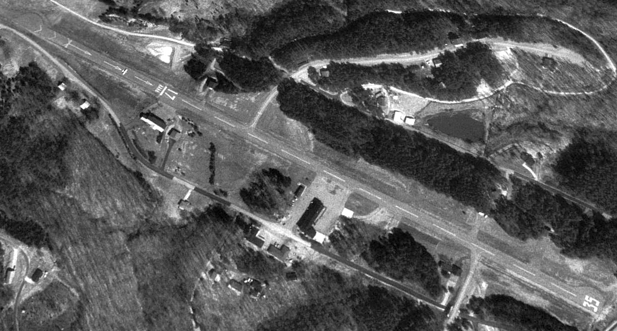
The earliest photo which is available of Spring Creek Airport was a 1997 USGS aerial view looking northeast.
It depicted Spring Creek Airport as having a single paved Runway 17/35.
The building & ramp remained on the west side, and 1 light single-engine aircraft was visible just shy of the Runway 17 displaced threshold (top-left of photo).
At some point between 1985-2010, Spring Creek Airport was evidently renamed Dale Hollow Regional Airport.
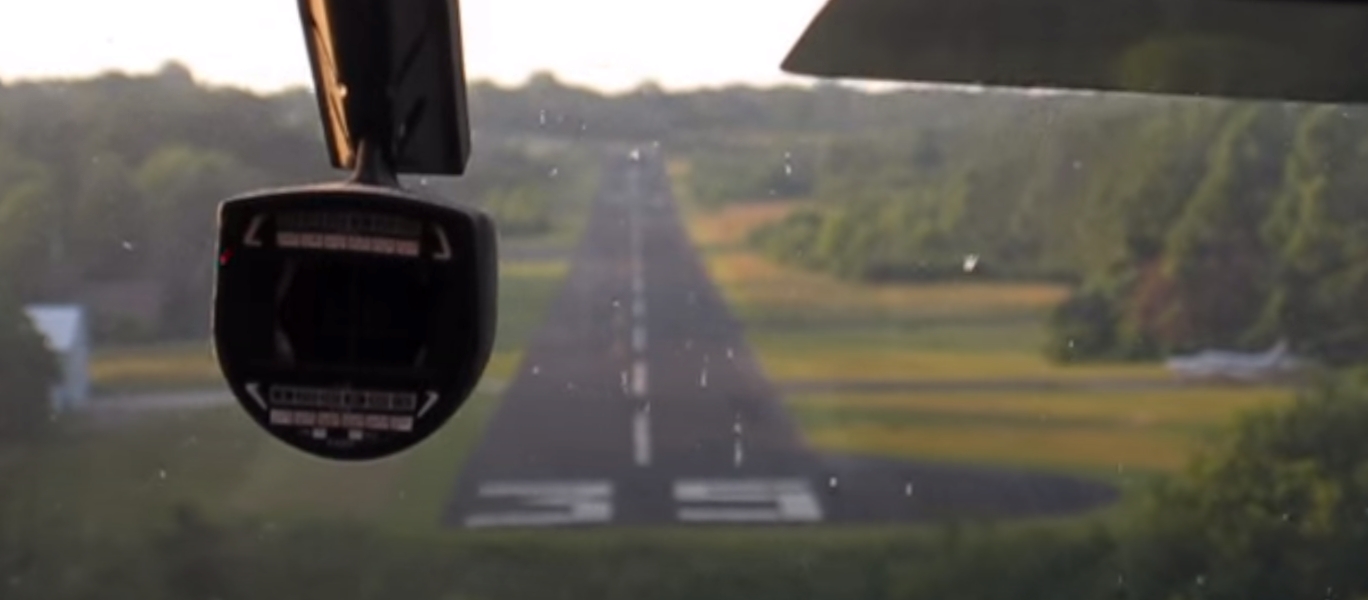
A still from a video taken on finale approach to Dale Hollow Regional Airport's Runway 35, with an aircraft parked just to the east.
The last photo which has been located showing an aircraft at Dale Hollow Regional Airport was a 2010 aerial view looking northeast.
One light single-engine aircraft was parked on the ramp on the west side.
As of 2013, FAA Airport/Facility Directory data for Dale Hollow Regional Airport described it as having a 3,380' asphalt Runway 17/35, “in fair condition”,
and it was said to conduct an average of 11 takeoffs or landings per day.
The owner was listed as Spring Creek Liquidation, and the manager as Howard Alpern.
The 2013 USGS topo map depicted “Dale Hollow Regional Airport / Petro Field” as having a single paved northwest/southeast runway.
A 2014 aerial view showed the former Dale Hollow Regional Airport office building remained intact.
A 2015 (or earlier) photo of the Spring Creek Airpark runway, with a hangar visible on the right.
A 2015 (or earlier) real estate listing advertised the 65 acres of Spring Creek Airpark for $875,000.
This property was described as being foreclosed upon, with the owner ready to release all remaining lots home with garage & apartment.
It was said to have previously been an air park with “numerous people flying in & out.”
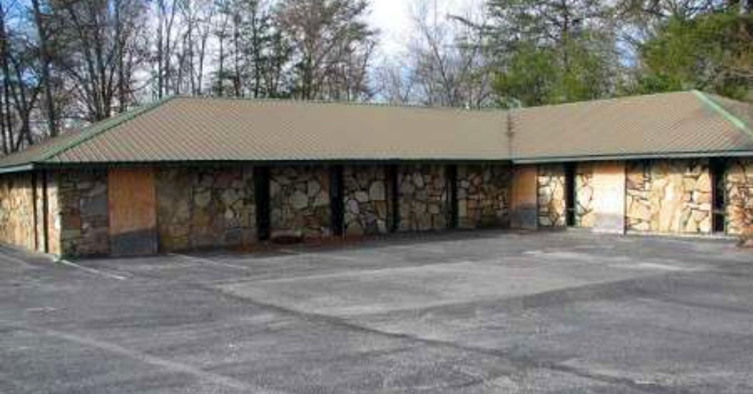
A 2015 (or earlier) photo of what may have been the Spring Creek Airpark office building.
A 2015 aerial view showed the former Dale Hollow Regional Airport office building had been demolished at some point between 2014-15.
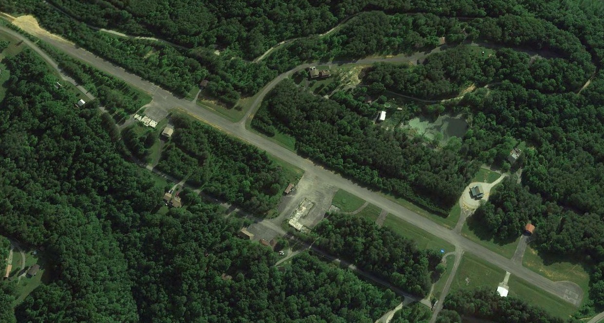
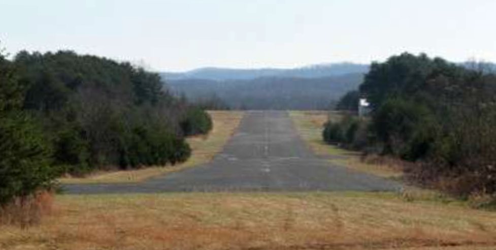
A 2018 aerial view looking northeast showed Dale Hollow Regional Airport's runway remained intact, with the runway markings faded but still visible.
As of 2020, street maps label it as Dale Hollow Regional Airport & Spring Creek Airport, and aeronautical charts depicted it as an abandoned airfield.
A 7/2/24 aerial view by Brad Baisley looking east showed Dale Hollow Regional Airport to remain intact.
Thanks to Brad Baisley for pointing out this airfield.
____________________________________________________
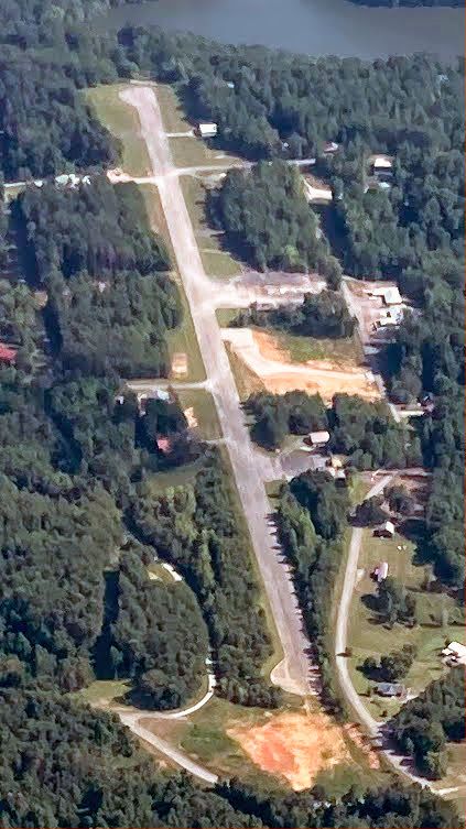
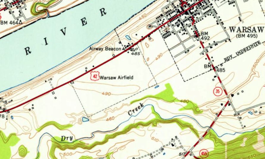
38.778, -84.911 (Southwest of Cincinnati, OH)
Warsaw Airport, as depicted on the March 1933 Cincinnati Sectional Chart.
The date of construction of this small general aviation airport has not been determined.
The earliest depiction which has been located of Warsaw Airport was on the March 1933 Cincinnati Sectional Chart.
It also depicted the Commerce Department Airway Beacon #5B about a mile to the southeast.
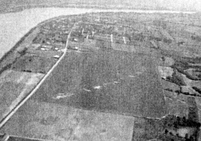
The earliest photo which has been located of Warsaw Airport was a circa 1945-49 aerial view looking northeast (from George Malcomb's book “The Last Kentucky Barnstormer”, courtesy of Ron Malcomb).
It depicted Warsaw Airport as a rectangular grass airfield.
Ron Malcomb observed, “The office is at the far end of the field in the upper-left corner.
You can see the wear & tear on the field where the aircraft landed in a diagonal run across the field.”
Ron Malcomb recalled, “My father, George Malcomb, operated a flight school at Warsaw Airport in the 1940s.
He had several Cubs & Aeroncas, a Stearman, and an AT-6.
He leased the ground after the military ended using the field after the war.
Most of the training was for guys returning from the military using the GI Bill.
There was a Link Trainer & a pool table in the office.
I was very young at the time but I do remember the office & flying with my dad.”
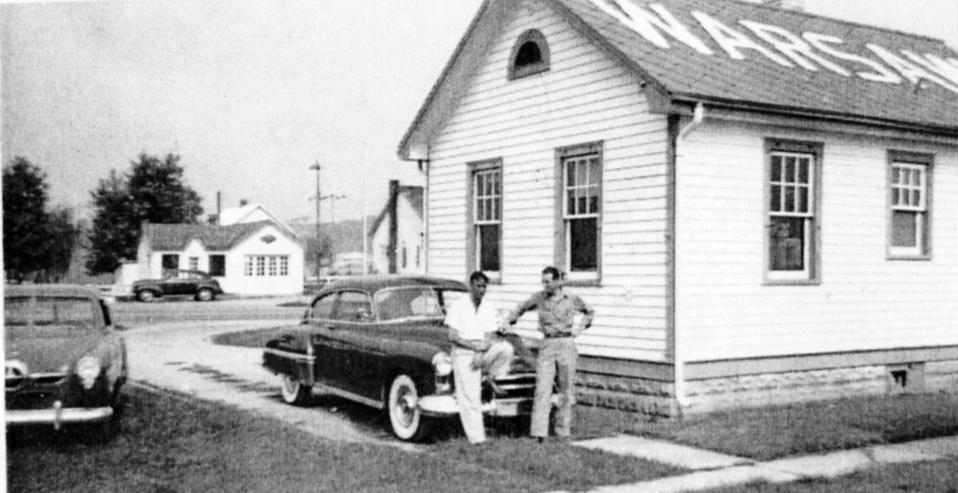
A circa 1945-49 photo of partners Joe Wise & George Malcomb in front of the Warsaw Airport office building (from George Malcomb's book “The Last Kentucky Barnstormer”, courtesy of Ron Malcomb).
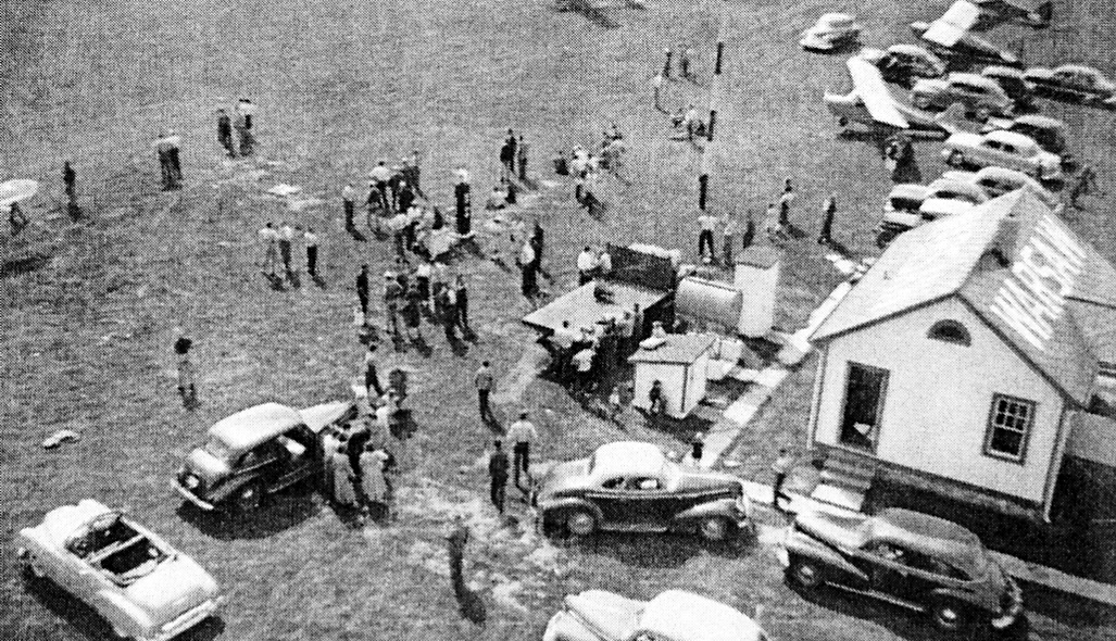
A circa 1945-49 aerial view of the Breakfast Fly-In at Warsaw Airport attended by Mr. Piper (from George Malcomb's book “The Last Kentucky Barnstormer”, courtesy of Ron Malcomb).
The last photo which has been located showing aircraft at Warsaw Airport was a 1949 aerial view.
It depicted Warsaw Airport as a rectangular grass airfield, with 2 light single-engine planes parked near a small building on the north corner.
The earliest topo map depiction which has been located of Warsaw Airport was on the 1951 USGS topo map.
It depicted “Warsaw Airfield” as a rectangular property outline, having a few small buildings on the north corner.

The last aeronautical chart depiction which has been located of Warsaw Airport was on the January 1952 Cincinnati Sectional Chart.
It depicted Warsaw Airport as having a 3,000' unpaved runway.
Warsaw Airport was evidently closed (for reasons unknown) at some point in 1952,
as it was no longer depicted on the June 1952 Cincinnati Sectional Chart.
However the nearby Commerce Department Airway Beacon #5B continued to be depicted.
A 1955 aerial view showed the site of Warsaw Airport had been subdivided & planted with crops, and the airport office building had been removed.
The only remaining trace of Warsaw Airport was the circular driveway on the north corner.
A 1965 aerial view showed the circular driveway had been removed from the north corner, erasing the last trace of Warsaw Airport.
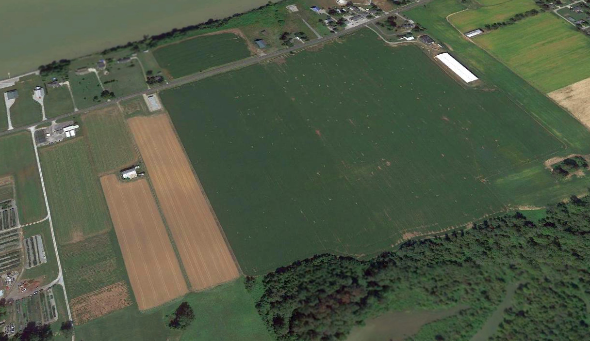
A 2016 aerial view looking north showed the majority of the Warsaw Airport site remained clear, but unrecognizable as a former airport.
Thanks to Ronald Malcomb for pointing out this airfield.
____________________________________________________
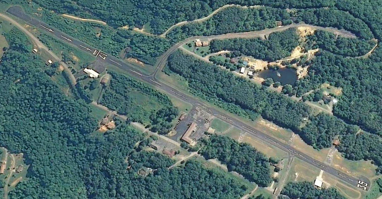
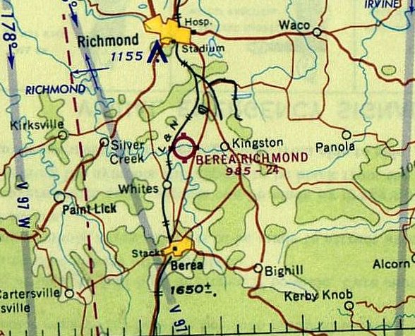
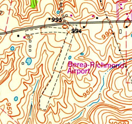
Berea-Richmond Airport / Lackey Airport, Berea, KY
37.646, -84.284 (Southeast of Lexington, KY)
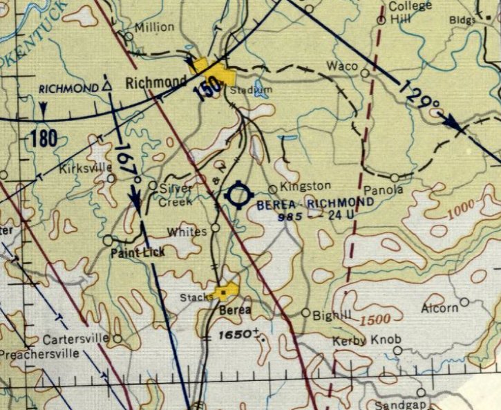
Berea-Richmond Airport, as depicted on the June 1958 Nashville Sectional Chart.
This small general aviation airport was evidently established at some point between 1957-58,
as it was not yet depicted on the 1954 USGS topo map or the June 1957 Nashville Sectional Chart.
The earliest depiction which has been located of Berea-Richmond Airport was on the June 1958 Nashville Sectional Chart.
It depicted Berea-Richmond Airport as having a 2,400' unpaved runway.
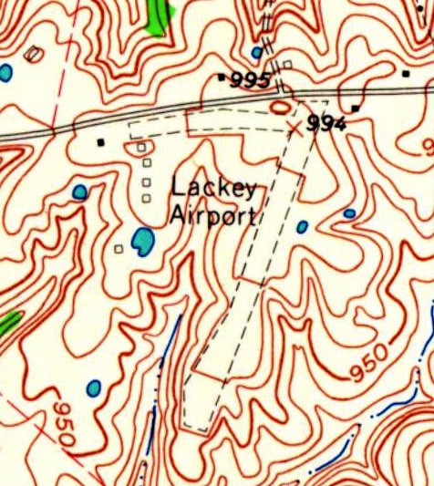
The earliest topo map depiction which has been located of this airport was on the 1965 USGS topo map.
It depicted “Lackey Airport” as having a single northeast/southwest unpaved runway, with a taxiway leading to 5 small buildings on the northwest side.
The earliest photo which has been located of Lackey Airport was a 1965 aerial view.
It depicted a single northeast/southwest unpaved runway, with 1 light single-engine aircraft parked near 5 small hangarss on the northwest side.
The 1965 Nashville Sectional Chart depicted Berea-Richmond Airport as having a 2,400' unpaved runway.
Eric Karnes recalled, “Lackey Field was located on Menelaus Road (KY-2880) west of US-25 between Berea & Richmond.
I went there frequently on weekends in the 1970s when a friend operated a skydiving club there.
Miller Lackey & his father before him operated the airport.
I remember Miller showing me a photo of a Civil Air Patrol Champ that was based at the airport years before.”
The 1979 USGS topo map depicted Berea-Richmond Airport
It was depicted as having a a single northeast/southwest unpaved runway, with a taxiway leading to 5 small buildings on the northwest side.
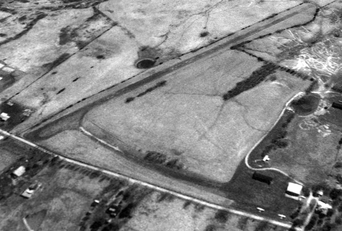
The last photo which has been located showing Berea-Richmond Airport in operation was a 1997 USGS aerial view looking southeast.
Three light single-engine planes were parked near the hangars on the northeast side (bottom-right).
Bearea-Richmond Airport has met the fate of so many other nice grassroots airports: a 2017 aerial view looking southeast shows it had been closed at some point between 1997-2017.
The individual T-hangars had been removed, but the grass runway remained.
The site of Berea-Richmond Airport is located southwest of the intersection of Menelaus Road & Raven Drive.
Thanks to Eric Karnes for pointing out this airfield.
____________________________________________________
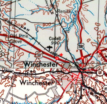
Codell Field / Histle Field, Winchester, KY
38.02, -84.22 (East of Lexington, KY)
Codell Field, as depicted on the 1956 USGS topo map.
Photo of the airfield while in use has not been located.
The date of establishment of this small airfield has not been determined.
The earliest depiction which has been located of Codell Field was on the 1956 USGS topo map.
Codell Field was not yet depicted on the January 1960 Nashville Sectional Chart.
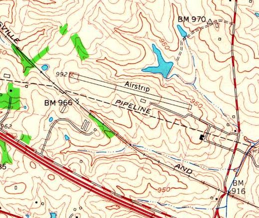
The 1965 USGS topo map depicted Codell Field as a single southeast/northwest runway, labeled simply as “Airstrip”,
with 1 small building on the south side.
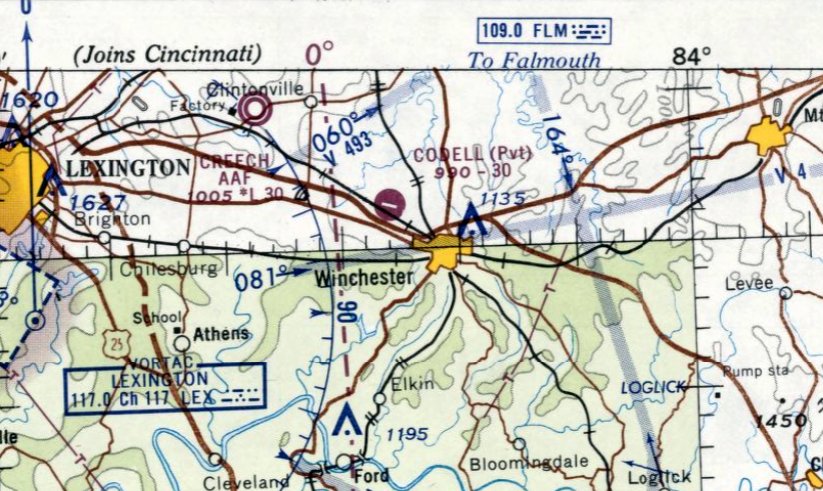
The earliest aeronautical chart depiction which has been located of Codell Field was on the January 1965 Nashville Sectional Chart.
It depicted Codell as a private field having a 3,000' paved runway.
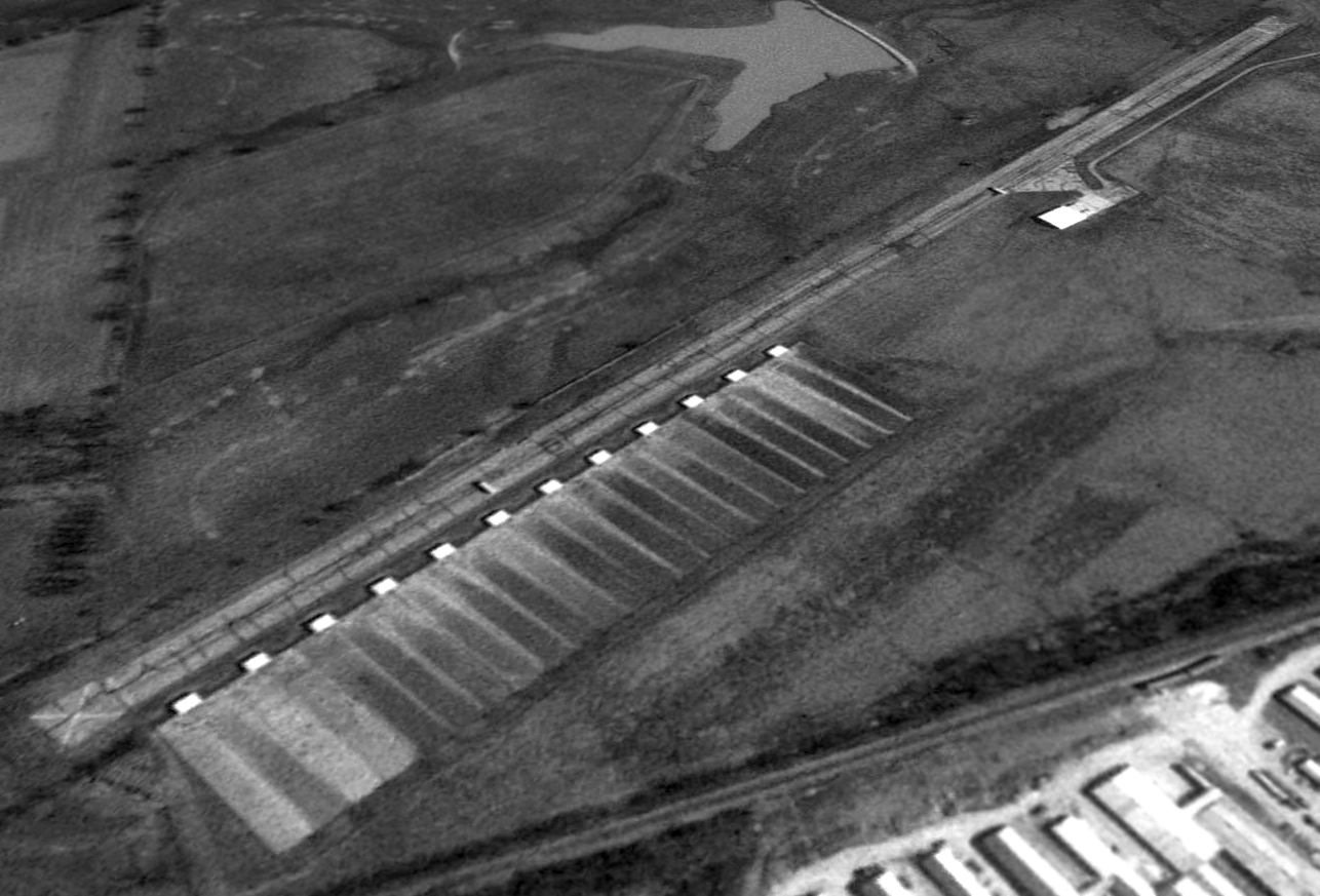
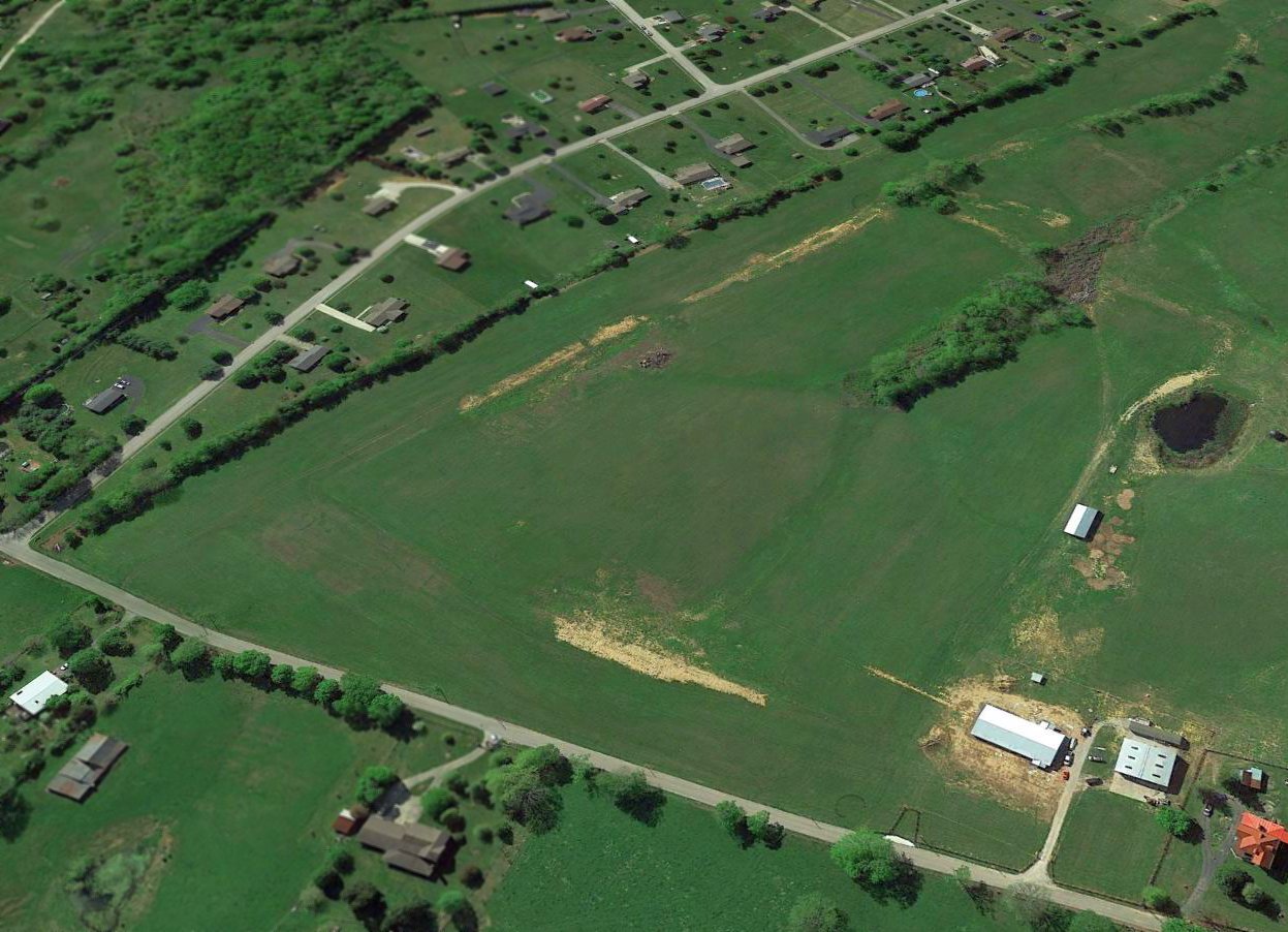
The earliest photo which has been located of Codell Field was a 1997 USGS aerial view looking northeast.
It depicted Codell as having a single paved runway, which was deteriorated & had closed-runway “X” symbols at each end.
A single hangar was located south of the runway.
A series of smaller buildings adjacent to the southeast side of the runway were presumably farm-related & not airfield-related.
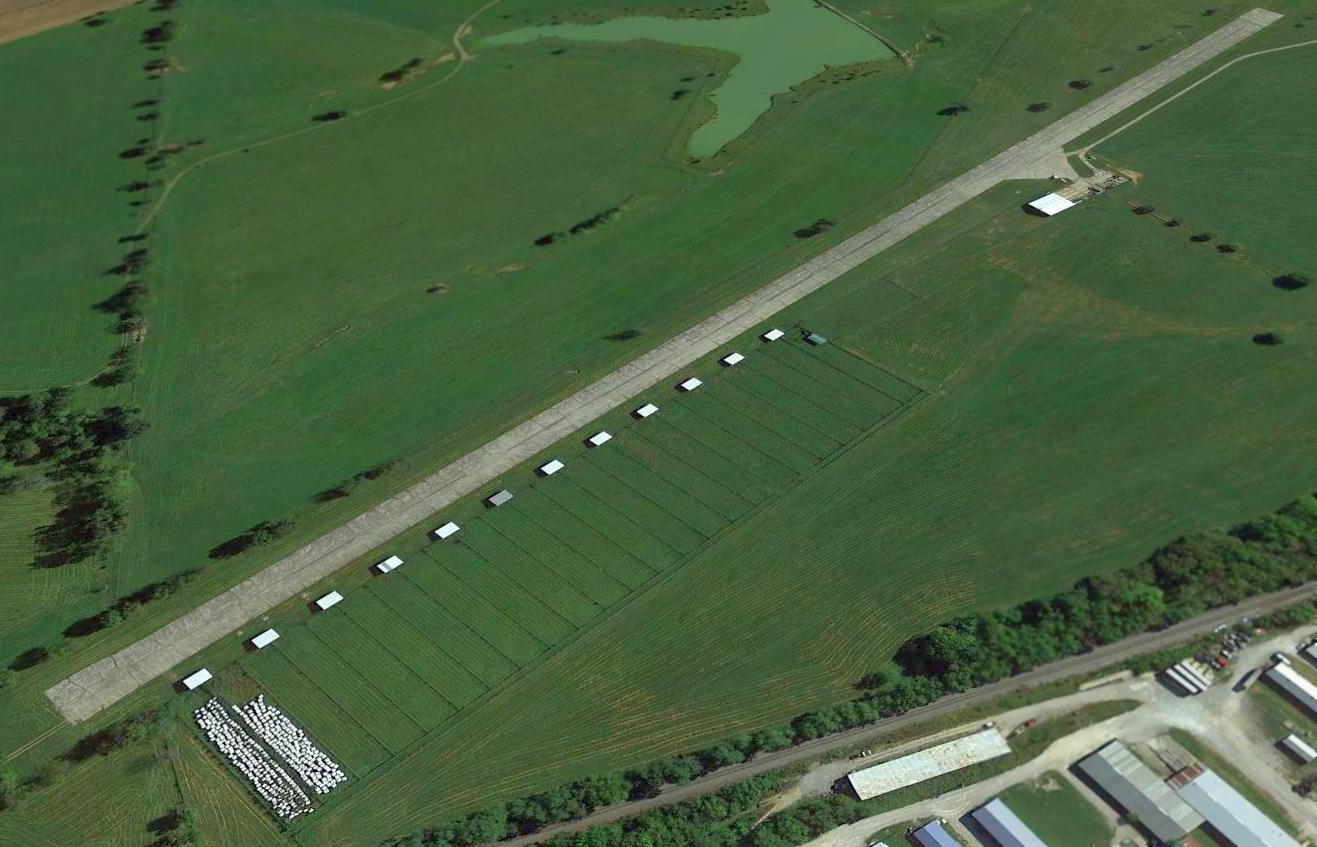
A 2014 aerial view looking northeast showed the Codell Field paved runway & hangar remained intact.
According to Jacob McHone, this airfield may also have been known as Histle Field.
Jacob reported in 2015, “Histle Field in western Winchester just north of Interstate 64...
Hangars are still there but last time I was there the drive is now a private drive & the airfield is now a farm.
The hangars are used as stalls; the runway looks in good shape still.
I assume the owner of Histle Field sold the land & moved to Mt. Sterling because there is a strip south of KIOB listed as Histle Field on the Cincinnati Sectional Chart.”
The site of Codell Field is located northwest of the intersection of Van Metre Drive & Rockwell Drive.
Thanks to Jacob McHone for pointing out this airfield.
____________________________________________________
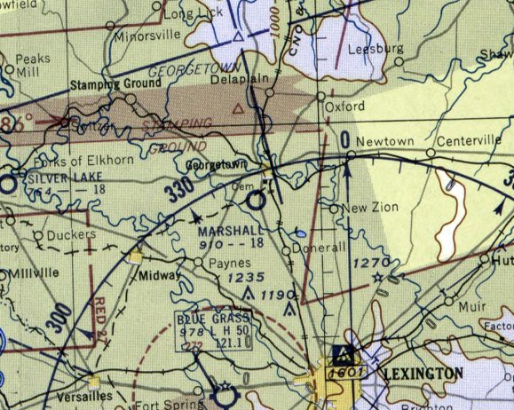
(Original) Marshall Field, Georgetown, KY
38.19, -84.57 (Northwest of Lexington, KY)
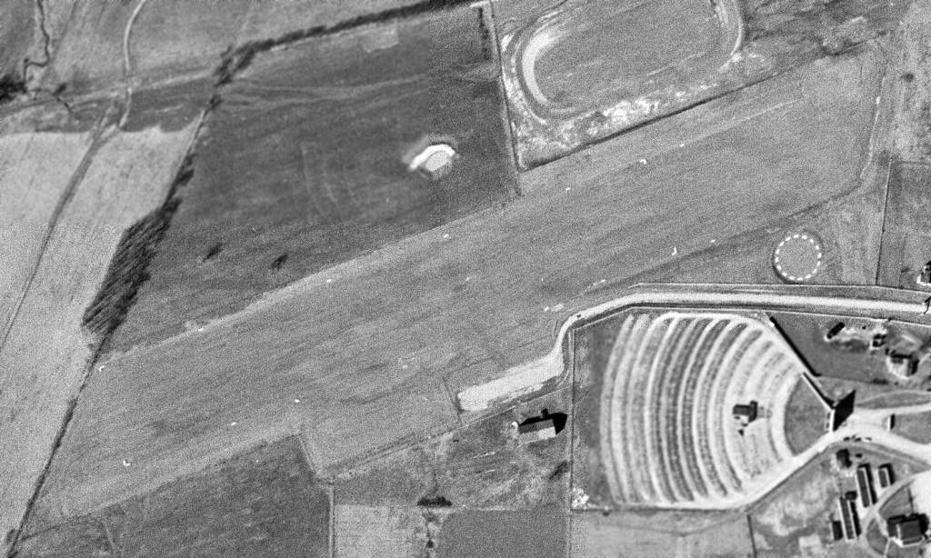
The original Marshall Field, as depicted on a 3/1/52 USGS aerial photo.
The original airport for the town of Georgetown was located on the south side of town.
The earliest depiction which has been located of the original Marshall Field was a 3/1/52 USGS aerial photo,
which depicted a very well-defined northeast/southwest grass runway, with a parking area & airport circle marking on the south side side.
There were no hangars on aircraft visible on the field.
There was also a drive-in movie theater directly adjacent to the south side of the runway, probably a little too close for comfort.
Eric Karnes recalled, “The original Marshall Field... was a short but busy little airport.
I remember the runway (about 1,800') running perpendicular to US-25.”
Marshall Field was not yet depicted on the December 1952 Cincinnati Sectional Chart.
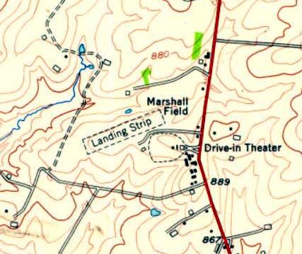
The 1954 USGS topo map depicted Marshall Field as having an unpaved northeast/southwest runway, with a drive-in theater adjacent to the south side.
The earliest aeronautical chart depiction which has been located of Marshall Field was on the June 1955 Cincinnati Sectional Chart.
It depicted Marshall Field as having a mere 1,800' unpaved runway.
A 1959 aerial view showed Marshall Field to be much busier,
with a total of 16 light single-engine aircraft on the parking area on the south side of the runway.
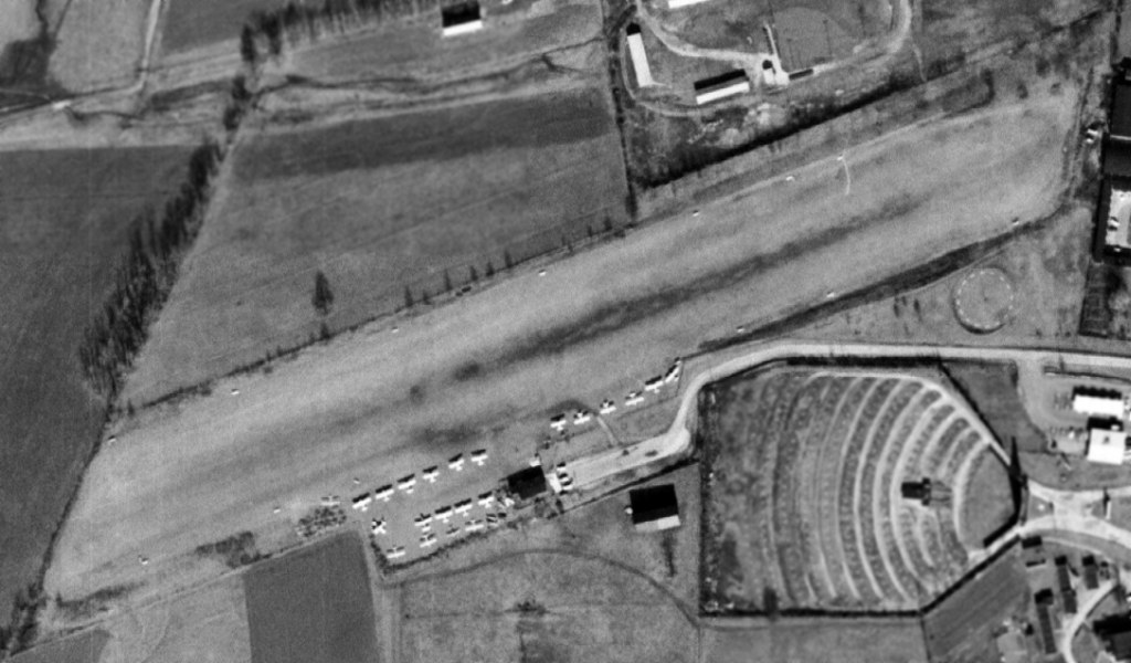
A 2/15/65 USGS aerial photo view of Marshall Field showed a dramatically different scene compared to the 1952 photo,
with a total of 22 light single-engine aircraft completely filling the available parking area on the south side of the runway.
Bill Karrer recalled, “In the spring & summer of 1973 the Air Force sent all of its ROTC Cadets at the University of KY who were selected for pilot training to Marshall field to train for a private pilot's license.
We really didn't know what useful training we were in for! A cornfield on the other side of the woven wire fence on one end & a furniture store on the other.
We had maybe 1,500' of useful runway! Nobody told us we were practicing short field takeoffs & landings on an unimproved grass, dirt, runway, every day!
Most of us, once we got our license, went to Lexington Bluegrass Field to get checked out in the 4-seat Cessna 172 as our instructions were in the 2-seat Cessna 150.
One of the things you were invariably asked to do by the Instructor Pilot was to see if you could set the plane down 'On the numbers'.
The confident reply would be, 'Which end of the numbers would you like for me to set the plane down on?'
The instrucor would ask, 'Where did you learn to fly?' When the answer was 'Georgetown', the challenge was withdrawn with a 'Never mind.'
Nearly 50 years later, we moved to Georgetown & a few months ago, four of us who became licensed pilots that year at Georgetown had lunch together & shared our memories of those 'Good ole days'.”"
The last topo map depiction which has been located of the original Marshall Field was on the 1993 USGS topo map.
Eric Karnes recalled, “The original Marshall Field... was replaced by a much larger Georgetown-Scott County Airport east of town.”
Georgetown-Scott County Airport opened in 1993, at which point the original Marshall Field was closed.
A 1994 aerial view showed the original Marshall Field remained intact, but devoid of any aircraft.
A 1997 aerial view showed several baseball diamonds had been constructed over the site of the original Marshall Field.
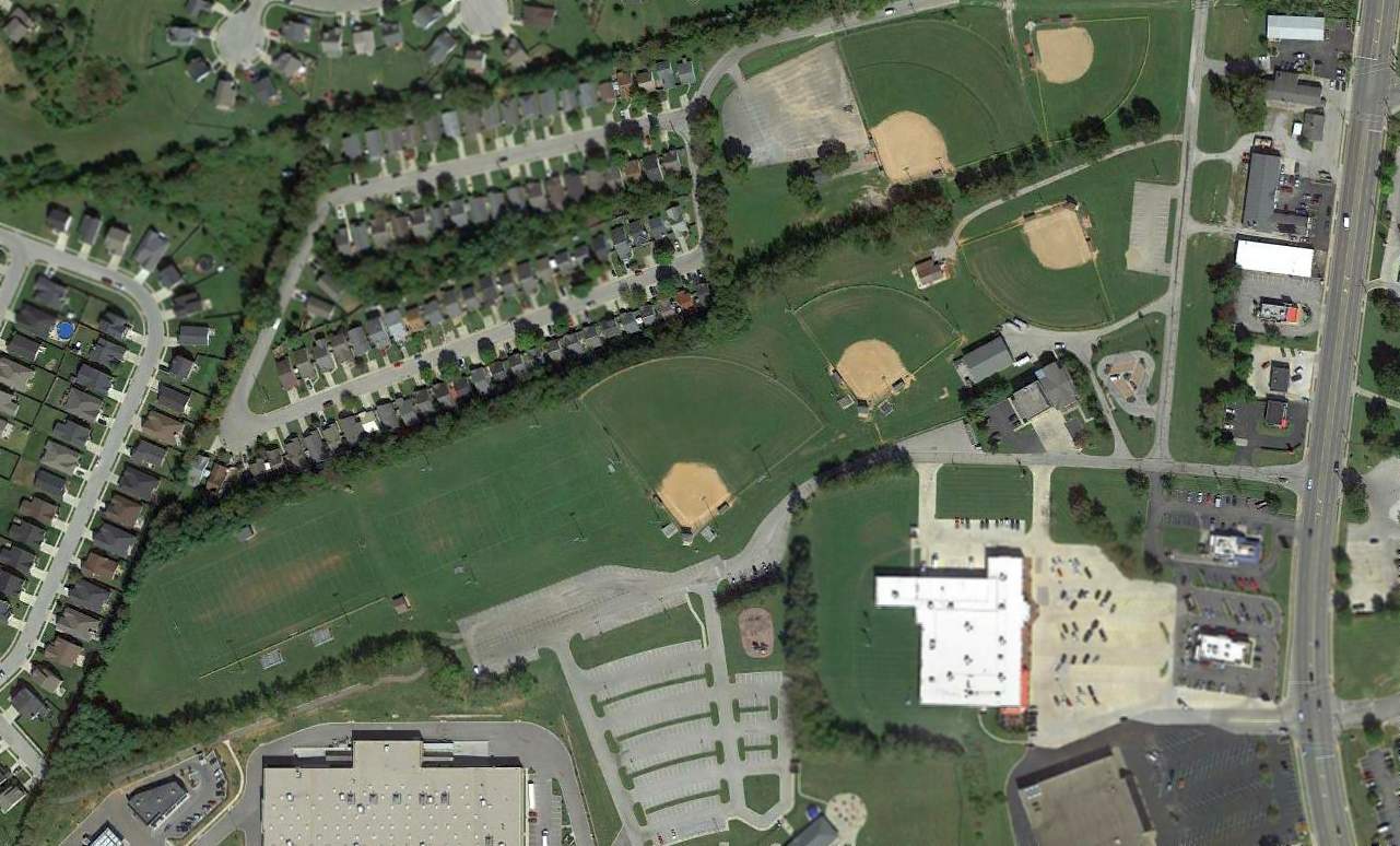
A 2014 aerial view of the site of the original Marshall Field shows the property reused as Marshall Park,
but the alignment of the former runway is still recognizable.
Eric Karnes reported in 2015, “The original Marshall Field... Today it's Marshall Park, on Airport Road at US-25.”
The site of the original Marshall Field is located at the western terminus of Airport Road, appropriately enough.
Thanks to Eric Karnes for pointing out this airfield.
____________________________________________________
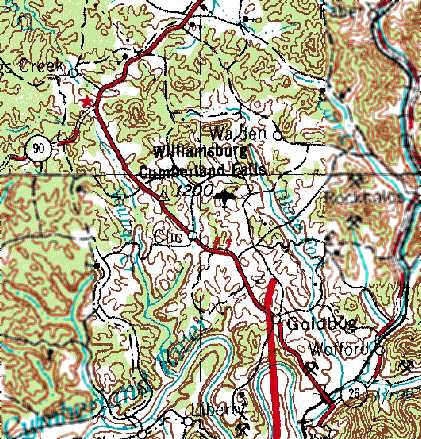
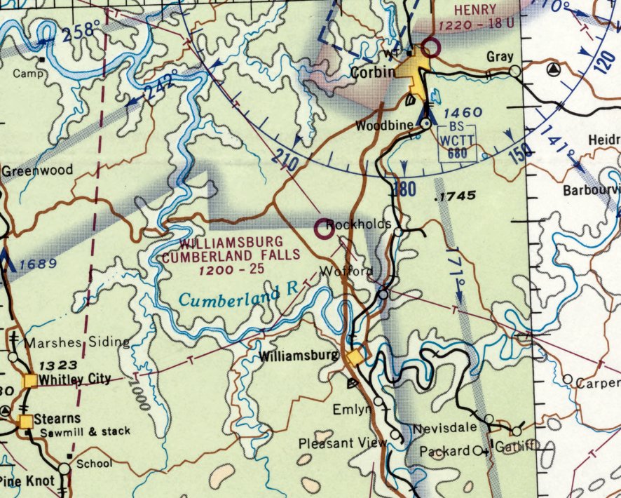
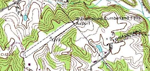
Williamsburg Cumberland Falls Airport (4I1), Williamsburg, KY
36.83, -84.19 (South of Lexington, KY)
The Williamsburg Cumberland Falls Airport, as depicted on the 1965 USGS topo map.
Williamsburg Cumberland Falls Airport was evidently established at some point between 1960-65,
as it was not yet depicted on the 1952 USGS topo map or the June 1960 Nashville Sectional Chart.
The earliest depiction which has been located of the Williamsburg Cumberland Falls Airport was on the 1965 USGS topo map.
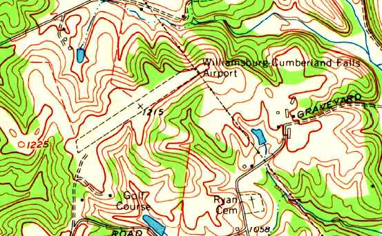
The 1969 USGS topo map depicted the Williamsburg Cumberland Falls Airport
as having a single unpaved northeast/southwest runway.
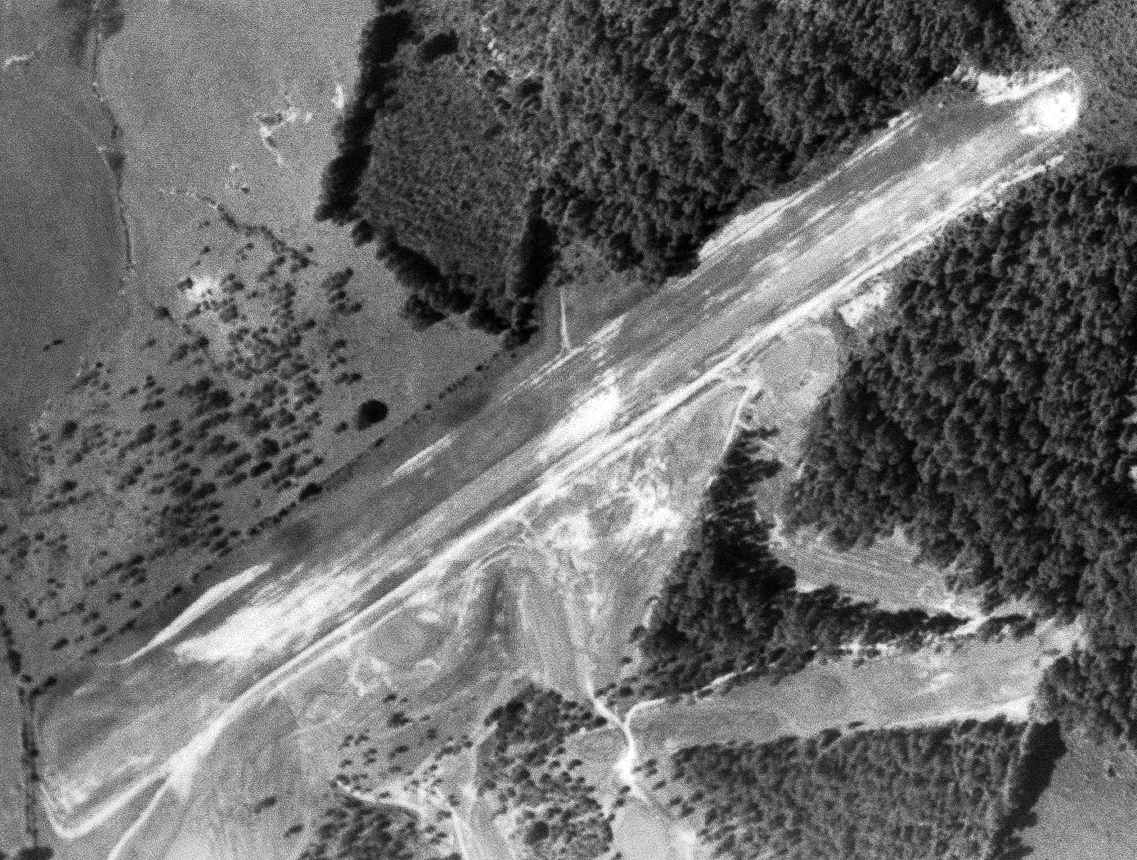
The earliest photo which has been located of the Williamsburg Cumberland Falls Airport was a 5/27/69 USGS aerial view.
It depicted the field as having a single unpaved northeast/southwest runway.
The earliest aeronautical chart depiction which has been located of the Williamsburg Cumberland Falls Airport was on the July 1969 Nashville Sectional Chart.
It depicted Williamsburg Cumberland Falls Airport as having a 2,500' unpaved runway.
The 1982 USGS topo map depicted the Williamsburg Cumberland Falls Airport
as having a single unpaved northeast/southwest runway.
A single small building had evidently been added on the southwest side at some point between 1969-82.
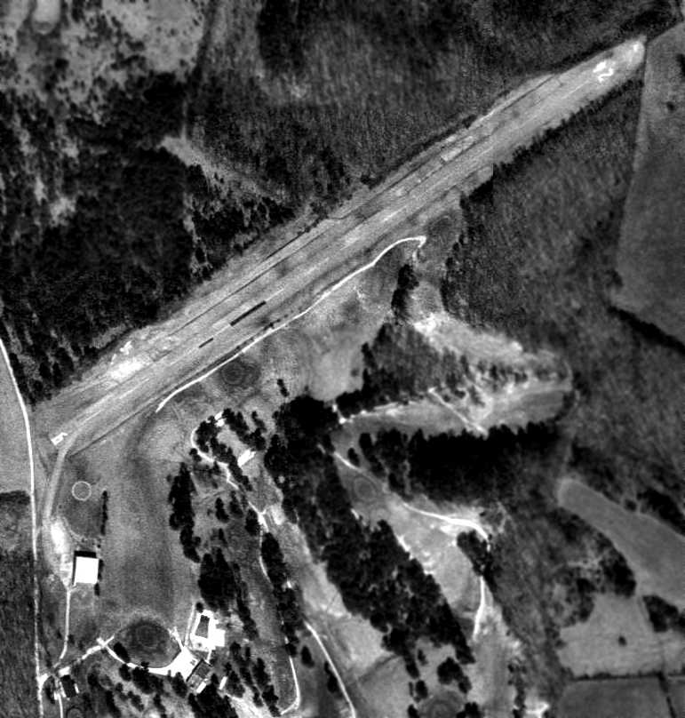
Williamsburg Cumberland Falls Airport had evidently gained a paved runway at some point between 1982-97,
as a 1997 USGS aerial view depicted the field as having a single paved Runway 6/24, with a single small hangar on the southwest side.
There were no planes visible on the field.
In March 2005 a larger Williamsburg-Whitley County Airport was built to the southwest,
and the Williamsburg Cumberland Falls Airport was presumably closed at the same time.
As of 2009 the Williamsburg Cumberland Falls Airport was no longer depicted on aeronautical charts.

A 2015 aerial view looking north shows the Williamsburg Cumberland Falls Airport remained intact.
The site of the Williamsburg Cumberland Falls Airport is located northeast of the intersection of Pilot Drive & Airport Road, appropriately enough.
Thanks to Aaron Renfro for pointing out this airfield.
____________________________________________________
Thorn Hill Airfield, Kenton, KY
38.86, -84.45 (South of Cincinnati, OH)
A 4/19/60 USGS aerial photo appeared to show the Thorn Hill Airfield when it was newly constructed.
According to drag racing historian Bret Kepner, this airfield had a colorful history.
Through information from locals & the track's employees during a visit around 1985,
he learned that "the airfield was built by alcohol bootleggers during Prohibition.
The airstrip was created deep in the woods where it was virtually undetectable from the ground.
The moonshine, brewed in the nearby Kentucky hills,
was smuggled on night flights to nearby Cincinnati, OH.
Near the end of Prohibition, the operations at the Kenton airstrip were sacked by Treasury agents,
resulting in a large number of arrests.
The Feds eventually bequeathed the seized land to the town of Kenton,
whose mayor apparently assisted in the bust.
However 1949 & 1952 USGS aerial photos just showed a farm field, with no recognizable sign of an airfield.
And no airfield was depicted at the site on the 1953 USGS topo map.
According to drag racing historian Bret Kepner, “The airstrip sat, unused, until the hot rodding craze of the 1950s
resulted in the local arrest of a young street racer...the mayor's son!
The mayor agreed to allow the kid to turn the abandoned airfield into a drag strip
if it would keep his son's racing activities off the street.
Thus was born Thorn Hill Drag Strip!"
The earliest photo which has been located of the Thorn Hill Airfield was a 4/19/60 USGS aerial photo.
It appeared to show the Thorn Hill Airfield when it was newly constructed,
with a single northeast/southwest runway.
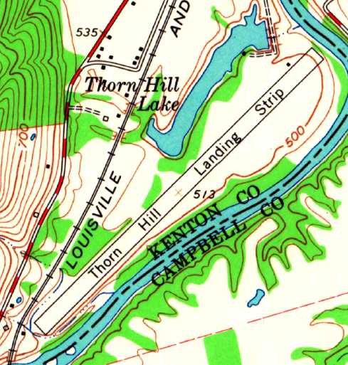
“Thorn Hill Landing Strip”, as depicted on the 1961 USGS topo map.
It was not listed among active civil airfields in the 1962 AOPA Airport Directory.
According to Steve Trutschel, “Ralf Payne owned & operated that property until his passing in the mid-1990s.
I used to fly my Cub in there all the time & if they were racing I would enter the pattern
and the guy lining up the cars at the starting line would hold them in place & motion me to land.
I flew in & watched the races many Saturday evenings as Thornhill is only about 5 miles from the private airstrip where I live.
I also flew ultralights into there years before I owned my Cub.”
Steve continued, “My father raced there when he was a kid in the mid-1950s
and it was a dirt drag strip when he started racing there.
Everyone would use snow tires for traction.
He remembers how great it was the day Ralf blacktopped the first 100 or 150 feet of the strip for traction for them.
When I was a kid in the mid-1960s there were at least 3 airplanes kept there.
I ended up buying a worn-out 1946 Stinson 108-3, that ironically, was one of the 3 planes that used to be kept there.
It is still very much country out there & I know of no ordinances that would prevent aircraft operations there.
Our nickname for the dragstrip was, and still is, Ralf's Palace.”
Steve continued, “Over the years I would have several friends fly into the dragstrip
and I would pick them up because my strip is very short & a Cub is one of the few planes that can go in there.
One day I met a couple of friends at the dragstrip & they were flying a completely restored Beech T-34,
complete with all the Navy military markings.
Ralf ALWAYS drove out & met you at the plane.
I assume it was Ralfs wife with him as he met the T-34.
My buddy slid the canopy back, stood up in the seat, looked around & said,
"I don't know, this doesn't look like Kansas to me!"
Ralfs wife stood there looking at the military plane in total disbelief
and said, "Oh my God, you guys are no where near Kansas!"”
Steve continued, “I quit flying the Cub in there because I tore it down to restore it.
Sadly Ralf passed away before it was finished & he never got to see it again.
I know several people that still race there every Saturday in the summer.
In this day & age there are more & more houses being built, and more & more complainers.
Most of the complainers are on the other side of the river & that is a different county so it is complicated.
But I enjoy the races & I can hear them at my house, It's just part of that area.
I know several people that race there & one of them has even asked the new owner if I could fly in there again.
His response to them was, "As long as I get an airplane ride." We'll see.”
The earliest depiction which has been located of the Thorn Hill Airfield was on the 1961 USGS topo map.
It depicted “Thorn Hill Landing Strip” as a single northeast/southwest runway, with a small building on the north side.
Thorn Hill was not listed among active civil airfields in the 1982 AOPA Airport Directory.
The 1983 USGS topo map depicted the single former runway but did not label it at all.
The former runway was labeled "drag strip" on the 1984 USGS topo map.
A 1993 USGS aerial view looking south showed Thorn Hill to not show any sign of recent aviation use.
The Thorn Hill property was also used until 2001 for flying radio controlled model aircraft, until that use was also precluded by zoning.
Thorn Hill was labeled "drag strip" on the 2002 Sectional Aeronautical Chart.
According to Jim Decker, the current property owner said zoning is causing problems with the drag strip,
and precludes him from renting tie-downs for aircraft.
The 7/9/01 issue of the Cincinnati Enquirer reported that neighbors had been making complaints about the noise from drag racing at Thorn Hill.
A circa 2006-2010 aerial view looking west at the north end of the former Thorn Hill runway, now reused as a drag strip.
An 11/14/12 aerial view by Paul Freeman looking northeast at the former Thorn Hill runway.
A 2017 aerial view looking south along the former Thorn Hill runway.
The Thorn Hill Airfield is located along the west bank of the Licking River,
a half mile southeast of the town of Kenton.
____________________________________________________
Creech Army Airfield, Arkansas City, KY
38.08, -84.32 (East of Lexington, KY)
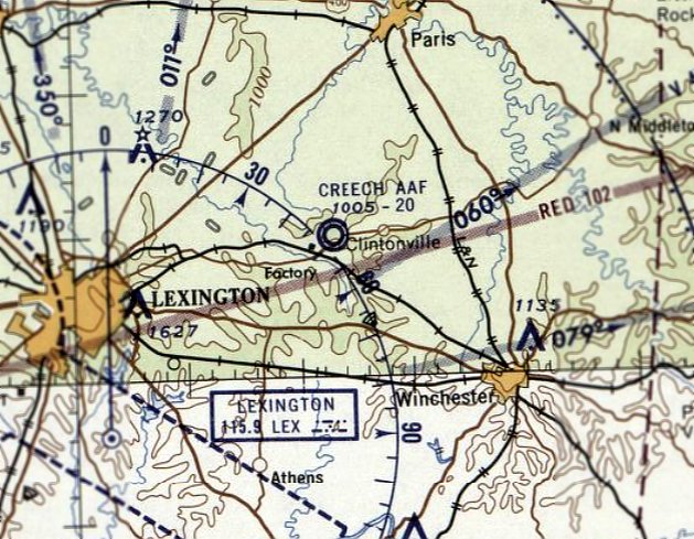
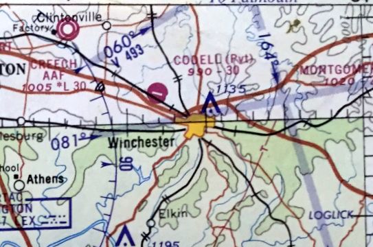
Creech AAF, as depicted on the March 1959 Cincinnati Sectional Chart.
According to an Army Corps of Engineers report, the Lexington Signal Depot
was built early in WW2 to store, repair & issue the Signal Corps' communications & electronic equipment.
Creech AAF was not yet depicted on the September 1958 Cincinnati Sectional Chart.
According to the 11/20/58 Lexington Herald (courtesy of Mark Hess), Creech Army Airfield was dedicated on 11/19/58.
The airfield was built to support the activities of the Lexington Blue Grass Army Depot.
The earliest depiction of Creech Army Airfield which has been located was on the March 1959 Cincinnati Sectional Chart.
It depicted Creech AAF as having a 2,000' unpaved runway.
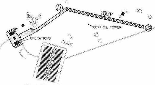
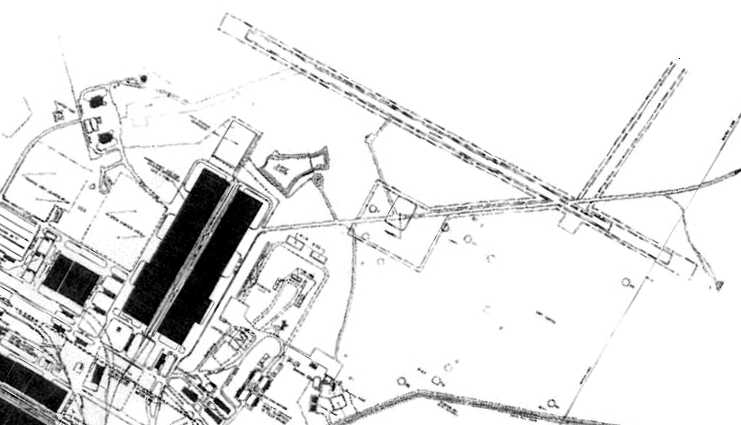
The 1960 Jeppesen Airway Manual (courtesy of Chris Kennedy) depicted Creech AAF as having a single 2,000' Runway 11/29,
with a taxiway leading to the southwest to a ramp with an operations building & several other buildings.
A control tower was depicted south of the runway.
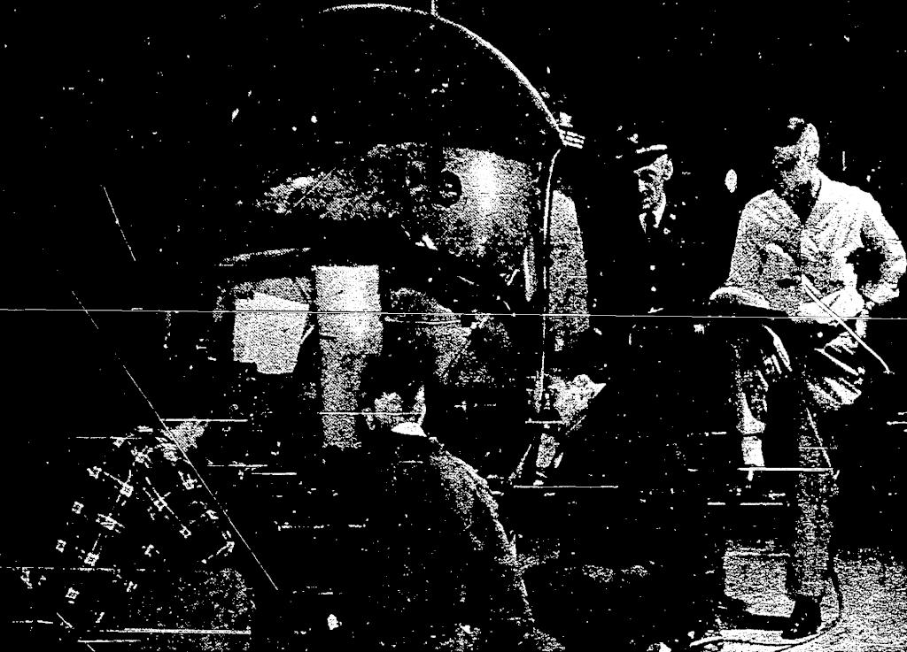
A January 1960 photo (courtesy of Mark Hess) of a Bell H-13 helicopter being refitted with new UHF & FM radio equipment by a Lexington Signal Depot avionics crew.
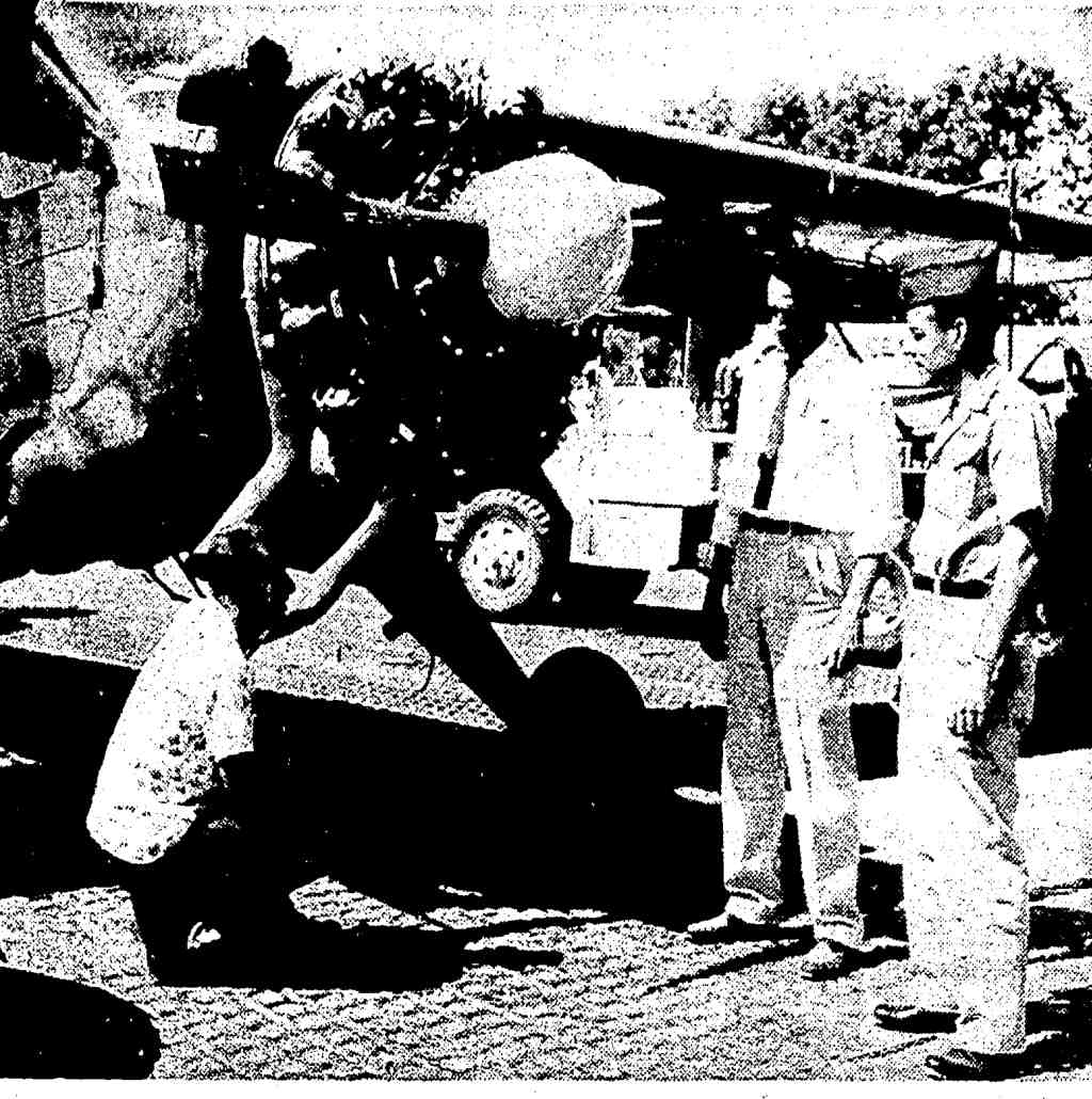
A March 1960 photo (courtesy of Mark Hess) of the Lexington Signal Depot's L-20 aircraft.
Creech AAF was described as having a 2,000' steel pierced planking runway & a control tower.
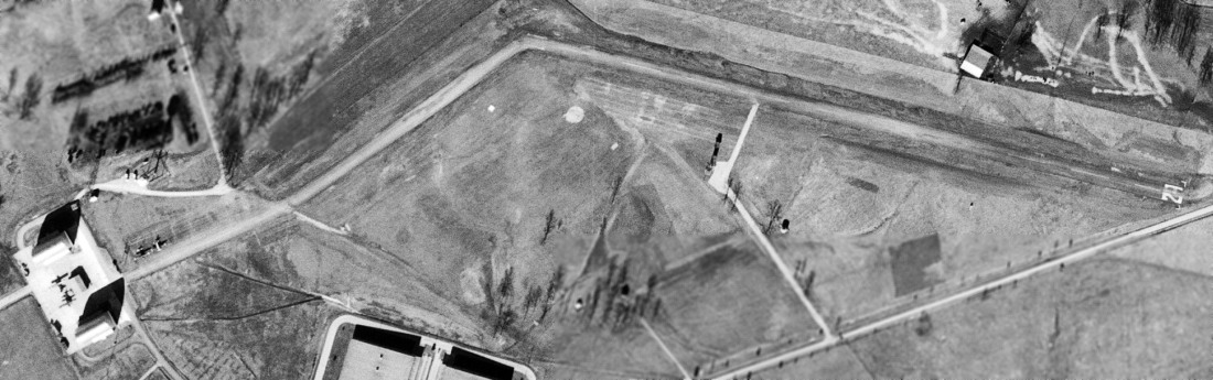
An 11/9/60 USGS aerial photo showed Creech AAF to have a single paved Runway 12/21,
with a taxiway connecting the runway to a ramp with two small hangars.
A control tower was south of the runway, and a total of 4 light fixed-wing aircraft were parked on the ramp.
The 1961 Cincinnati Sectional Chart (courtesy of Chris Kennedy) described Creech AAF as having a single 3,000' pierced steel planking runway.
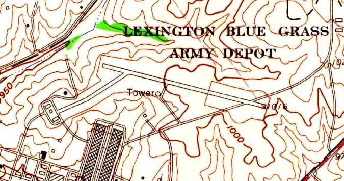
The 1965 USGS topo map depicted Lexington Blue Grass Army Depot as having an airfield with a single paved northwest/southeast runway,
a tower, and a taxiway leading to a ramp with 3 buildings on the southwest side.
The January 1966 Nashville Sectional Chart (courtesy of David Stevenson) depicted Creech AAF as having a 3,000' paved runway.
The 1968 Cincinnati Sectional Chart (according to Chris Kennedy) described Creech AAF as having a single 3,000' pierced steel planking runway.
Creech AAF, as depicted on the 1970 Cincinnati Sectional Chart (courtesy of Chris Kennedy).
A 1974 Facility Layout Plan of the Lexington Blue Grass Army Depot,
depicting the existing runway & the (apparently planned but never built) crosswind runway.
William Kempf recalled that in 1984 "I was stationed there & it had a nice set of runway lights & bumpy dirt runway."
He recalled that the runway would have been usable for small single engine fixed wing aircraft.
"But what I remember most was a large 75' high x 100' wide x 200' long hangar from at least the mid 1940's
that seems to be on the map but is missing from the photo?"
The Depot was placed on the Base Realignment & Closure list in 1991, and was scheduled to be transferred to the Kentucky National Guard in 1994.
According to JSH, "The depot's main DOD contractor, Raytheon,
moved most of its operations to the Blue Grass Army Depot in Richmond after the Lexington Blue Grass Army Depot's closing."
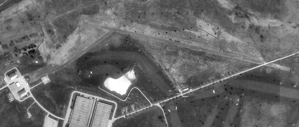
As seen in the 1993 USGS aerial photo, the Creech airfield consisted of a single 3,000' paved runway (which was crossed along its southeastern end by a road),
and a taxiway connecting the runway to a ramp with two small hangars.
There was no sign of the control tower depicted on the 1960 diagram.
East of the ramp was a helipad which was built at a later date than the runway, as it did not appear in the above 1974 plan,
and it appeared to have been used up to a later date than the runway.
The date of closure of the Creech airfield is unknown,
but it was depicted as an abandoned airfield on the 1998 World Aeronautical Chart.
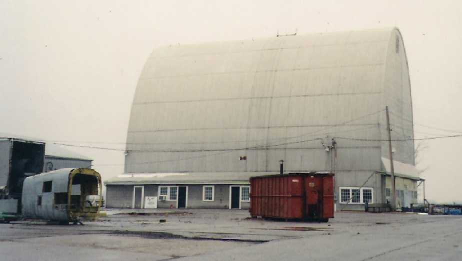
A circa 2002 photo by William Kempf of the odd-shaped building at Creech AAF,
with what appears to be a rear fuselage portion from an unidentified aircraft at left.
William reported, “They seem to be used sometime before 2002 for helicopter depot rebuilding.”
Bill North reported in 2003 that the "odd shaped buildings or Quonset huts…
that is where the first radar units were tested after their development.
Other than the metal outer skin, there is no metal in the building & the interior is all wood."
Bill reported of the buildings used for the first radar testing,
"There has been some talk as to placing them under some sort of historical preservation but I am not sure the status of that effort."
A 2004 aerial photo showed dramatic changes since the 1993 photo,
with the runway pavement having been completely removed,
and a new hangar & helipad having been built just northeast of the odd-shaped buildings southwest of the runway.
A 2006 aerial view showed further changes since 2004, with a second, larger hangar having been built over the site of the helipad,
and a replacement helipad having been constructed on the east side of the 2 hangars.
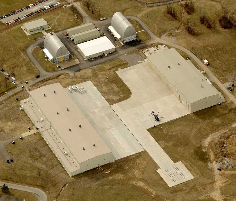
A circa 2006-2008 aerial view looking west showing the odd-shaped buildings at the top of the photo,
along with the recent-construction National Guard hangars & helipad, along with a sole UH-60 Blackhawk.
A 2008 aerial view showed 2 CH-47 Chinooks on the ramp,
and a new paved taxiway leading to 2 paved helipads located over the location of the west end of the former paved runway,
bringing the facility full-circle in a sense.
____________________________________________________
Since this site was first put on the web in 1999, its popularity has grown tremendously.
If the total quantity of material on this site is to continue to grow,
it will require ever-increasing funding to pay its expenses.
Therefore, I request financial contributions from site visitors,
to help defray the increasing costs of the site
and ensure that it continues to be available & to grow.
What would you pay for a good aviation magazine, or a good aviation book?
Please consider a donation of an equivalent amount, at the least.
This site is not supported by commercial advertising –
it is purely supported by donations.
If you enjoy the site, and would like to make a financial contribution,
you
may use a credit card via
![]() :
:
Please consider checking the box to make a monthly donatation.
For a mailing address to send a check, please contact me at: paulandterryfreeman@gmail.com
If you enjoy this web site, please support it with a financial contribution.
please contact me at: paulandterryfreeman@gmail.com
If you enjoy this web site, please support it with a financial contribution.
____________________________________________________
This site covers airfields in all 50 states.