Abandoned & Little-Known Airfields:
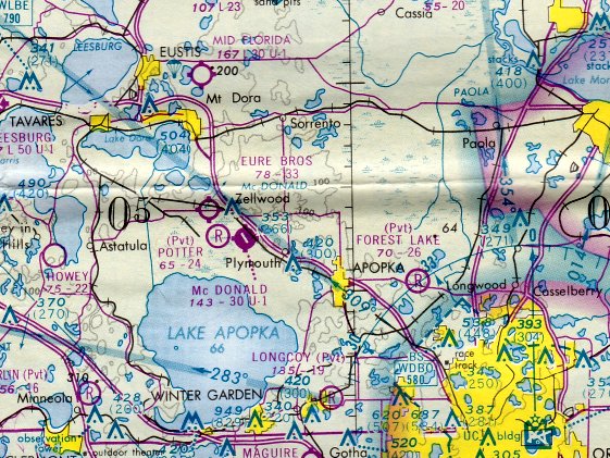
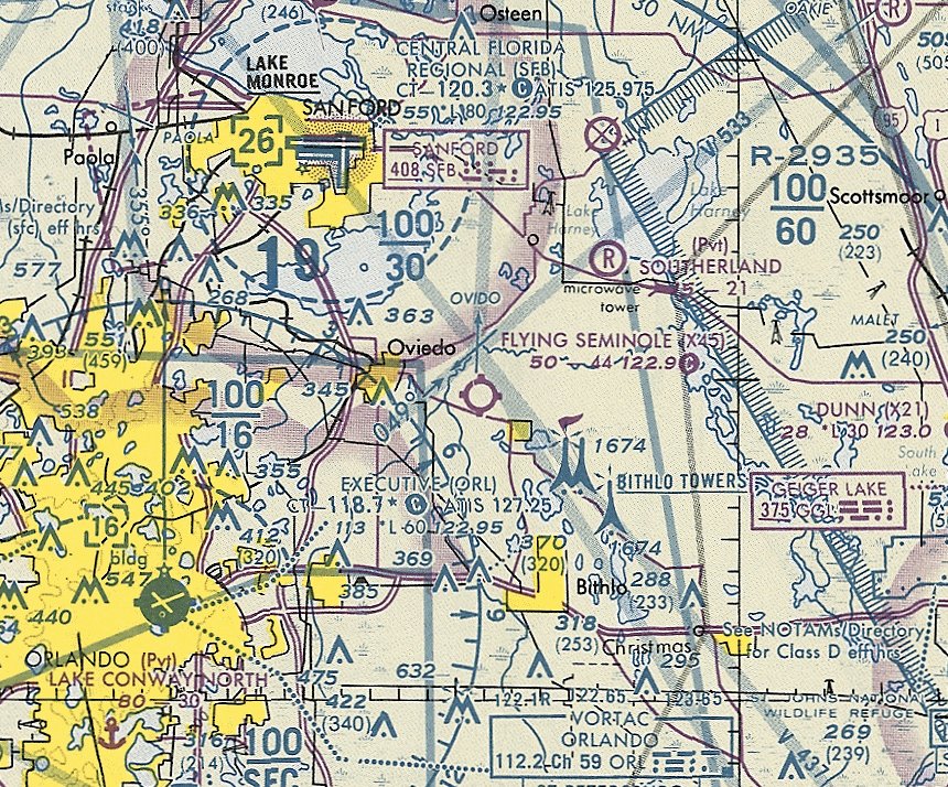
Florida: Northern Orlando area
© 2002, © 2024 by Paul Freeman. Revised 9/2/24.
This site covers airfields in all 50 states: Click here for the site's main menu.
____________________________________________________
Please consider a financial contribution to support the continued growth & operation of this site.
Betsy Ross Airport / De Land Orange Airport (revised 6/1/21) - Cannon Mills Airport (revised 9/2/24) - Florida Flying Gators Airport (added 3/10/22) - Flying Seminole Ranch (revised 10/7/21)
Howey Airport (revised 10/7/21) - Mt. Plymouth Airport (revised 9/23/19) - Ryan Municipal Airport (revised 9/2/24) - Showalter Airpark (revised 10/7/21)
Silver Springs Airpark (revised 9/23/19) - Taylor Field (revised 9/2/24) – Potter Field / Zellwin Farms Airport (revised 6/3/21)
____________________________________________________
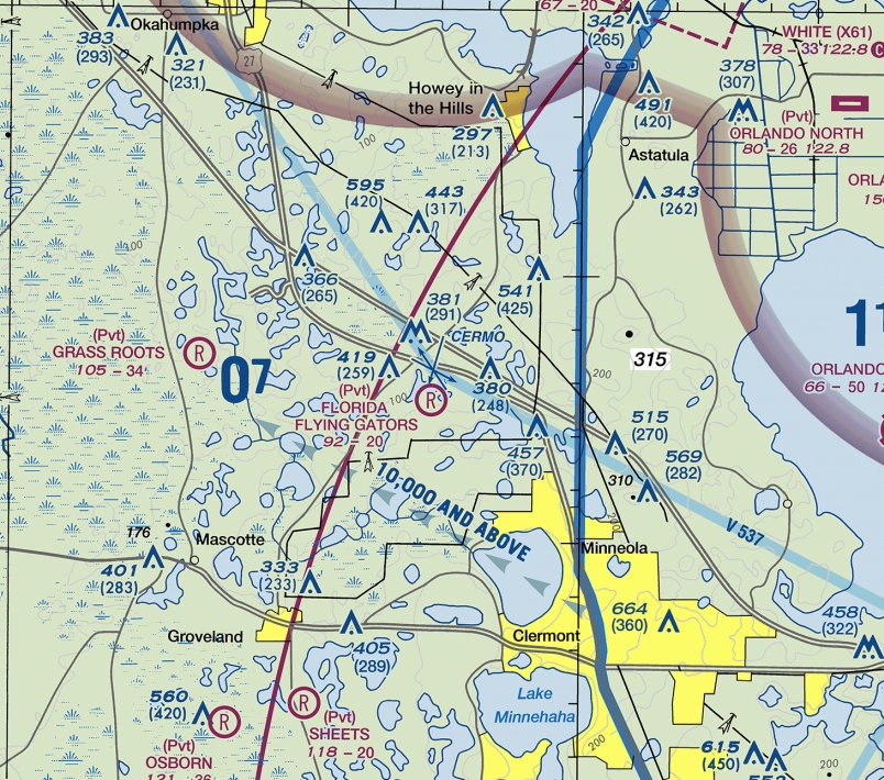
Florida Flying Gators Airport (3FD4), Mineola, FL
28.628,-81.803 (Northwest of Orlando, FL)
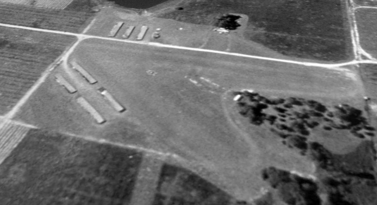
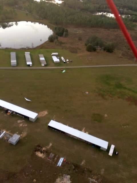
A 1994 aerial view looking southwest at Flying Gators Airport.
No airport was yet depicted at this site on a 1984 aerial photo.
John Sarra reported of Flying Gators Airport, “They started in the 1980s at a different airport that became a shopping mall then moved to this site in the mid-1980s.”
According to its FAA Airport/Facility Directory data, Florida Flying Gators Airport was activated in October 1987.
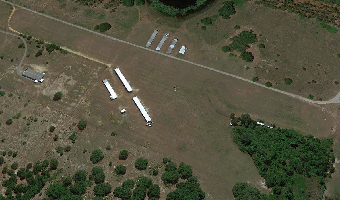
The earliest depiction which has been located of Flying Gators Airport was a 1994 aerial view.
It depicted 2 short grass runways, with a total of 7 hangars on either side.
John Sarra reported, “At its peak 'Gatorpark' hangars were full with a waiting list, mostly ultralight & light sport, 2,200' grass runway, clubhouse and more.”
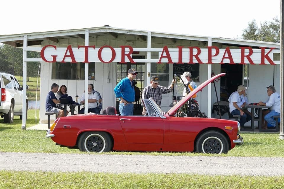
An undated photo of a pretty MG in front of the Gator Airpark clubhouse (courtesy of John Sarra).
John Sarra reported, “Some of the pilot members were also car guys.”
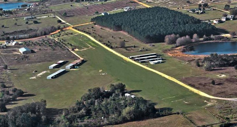
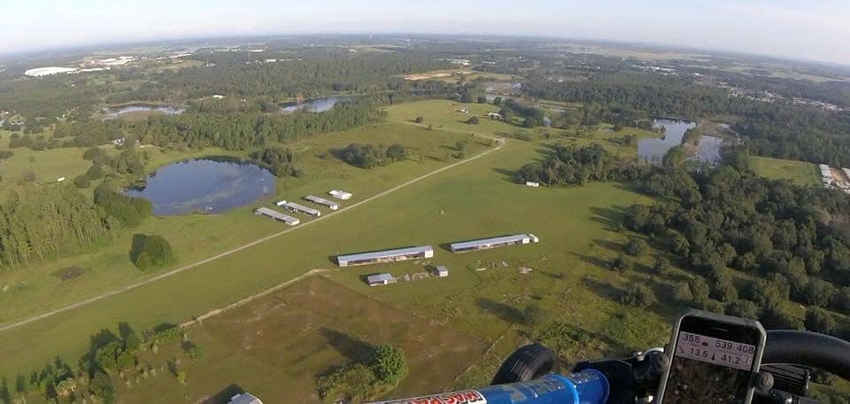
An undated aerial view looking southwest at Flying Gator Airpark.
The 2012 USGS topo map labeled “Florida Flying Gators Ultralight Airport”, but did not depict any runways or other details.
The 2015 USGS topo map no longer depicted Flying Gators Airport.
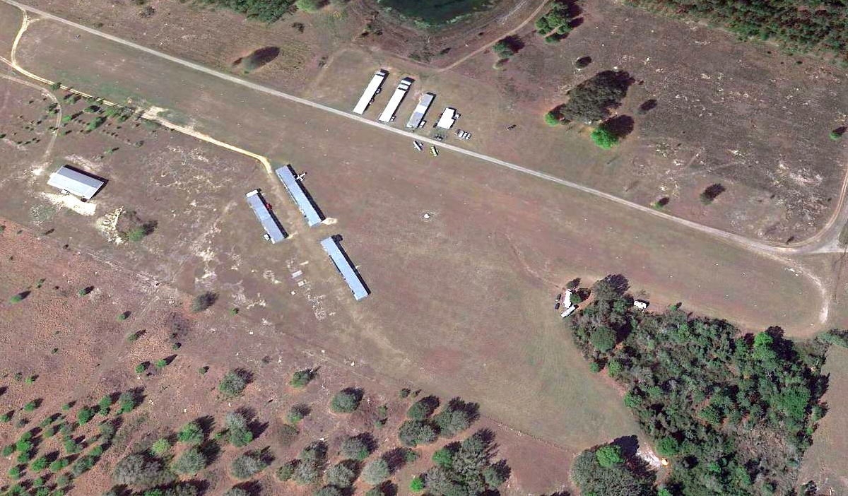
A 2017 aerial view looking southwest showed 2 or 3 light aircraft parked outside at Flying Gator Airpark.
The earliest aeronautical chart depiction which has been located of Flying Gator Airpark was on the August 2020 Orlando Terminal Chart.
It depicted Florida Flying Gators Airpark as a private airfield having a 2,000' unpaved runway.
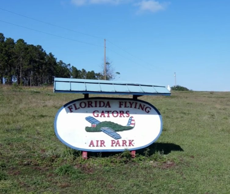
A 2021 photo of the Florida Flying Gators Air Park entrance sign.
A 2021 aerial view looking southwest did not show any aircraft at Flying Gator Airpark.
A 2021 aerial view looking northwest did not show any aircraft at Flying Gator Airpark (courtesy of John Sarra).
A 2021 aerial view looking west showed 2 ultralight aircraft at Flying Gator Airpark (courtesy of John Sarra).
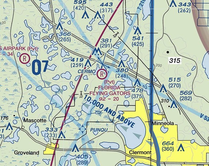
The January 2022 Orlando Terminal Chart depicted Florida Flying Gators Airpark as a private airfield having a 2,000' unpaved runway.
As of 2022, the FAA Airport/Facility Directory data described Florida Flying Gators Airport as having 2 turf runways: 2,000' Runway 18/36 & 1,100' Runway 5/23.
The owner was listed as FL Flying Investment Group, and the manager as Alan Resnick.
John Sarra reported of Flying Gator Airpark, “As of 1/1/22 it was closed; all hangars have been removed, and it will soon be a subdivision.
The generous souls who own the land let the club use it for over 3 decades for modest rent but the Central FL real estate market is exploding;
it was going to happen sooner or later with the club not owning the land.”
On 1/8/22, Flying Gators Airport manager Alan Resnick reported, “Gator Air Park is closed.”
Thanks to John Sarra for pointing out this airfield.
____________________________________________________
Betsy Ross Airport / De Land Orange Airport, Orange City, FL
28.938, -81.311 (Northeast of Orlando, FL)
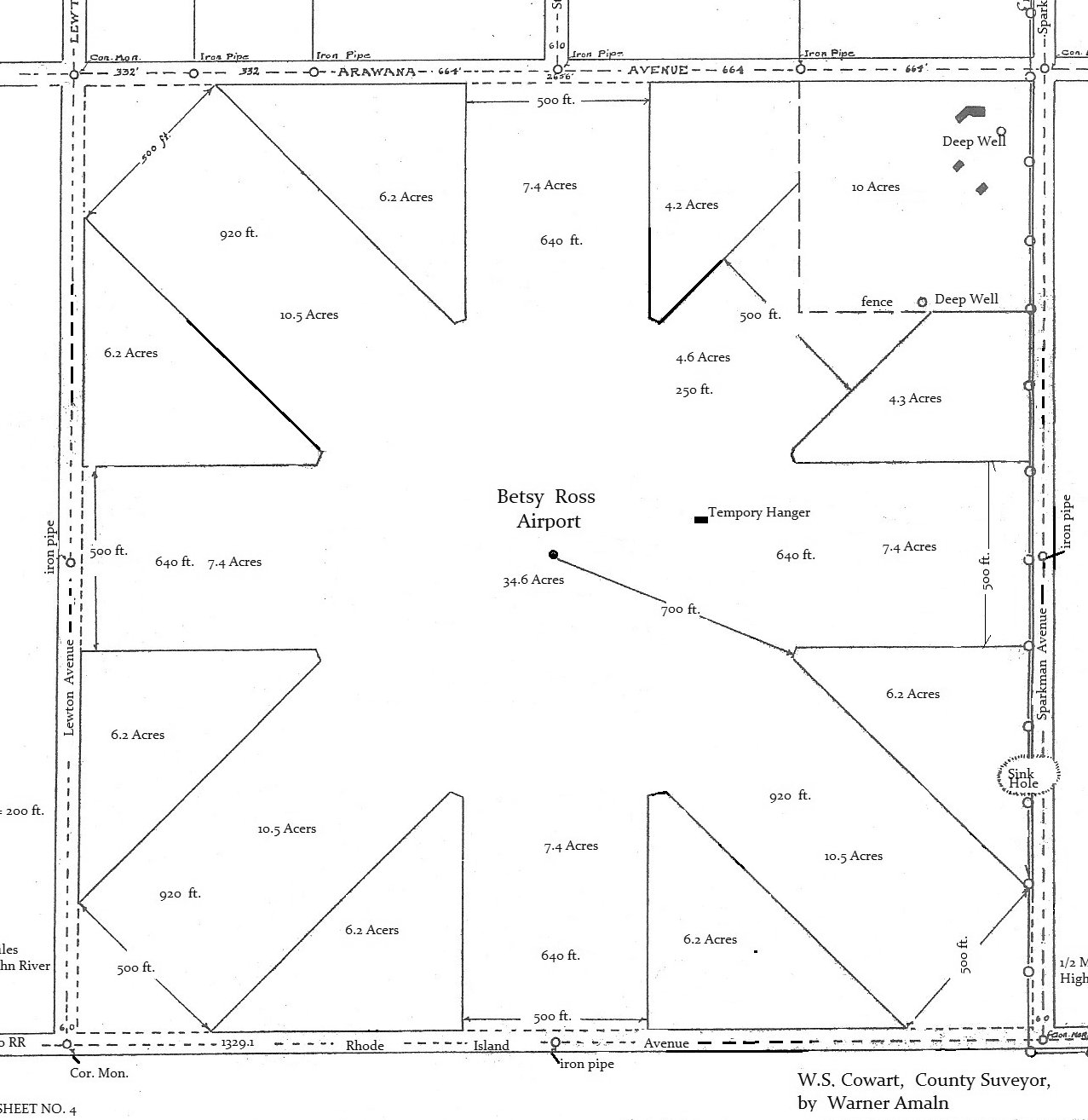
A 1933 survey plat of Betsy Ross Airport (courtesy of Richard Moravsik).
According to the article "Orange City Once Had Own Airport" by Gary Moore (courtesy of Patrick Morris),
“Once upon a time, Orange City had an airport. Now it's a field of weeds and scrub growth.
Some longtime residents, however, can remember the day when 'the grandfather of aviation' buzzed the treetops,
with his full beard flying in the prop-wash, then brought his biplane in for a dust kicker landing on the dirt runways of the old airport.
The bearded pilot was not a character out of aviation mythology.
He was Charles Dickinson, the brother of Dr. Frances Dickinson of Orange City.”
According to Richard Moravsik, “Frances Dickinson donated 160 acres to the newly-formed Betsy Ross Air Corps, under the leadership of Opal Kunz.
The airport was intended to be used as a training site for women pilots.”
Former Orange City resident Harold Culp, now of Miami, says he can remember when Charles Dickinson used to fly in occasionally to visit his sister.
"He was quite a colorful character, with that full beard & all," Culp recalls.
Culp did quite a bit of flying from the old airport, too.
The land for the airport, which was about a half mile west of Sparkman Avenue, was donated by Dr. Frances Dickinson.
She also sponsored the construction of the runways & actual opening of the airport for use by private planes.
There were no regular scheduled commercial flights out of the Orange City Airport, Culp said.
According to Culp, the airport was opened about 1933.
The runway system included a circular area in the center of the field with north/south & east/west runways radiating from it.
"There were several other smaller runways & taxi strips, but weren't used & included a large hangar, he added.
The earliest depiction which has been located of Betsy Ross Airport was a 1933 survey plat (courtesy of Richard Moravsik).
It depicted Betsy Ross Airport as having 4 unpaved runways.
The earliest aeronautical chart depiction which has been located of Betsy Ross Airport was on the December 1935 Orlando Sectional Chart.
It depicted Betsy Ross as an auxiliary airfield.
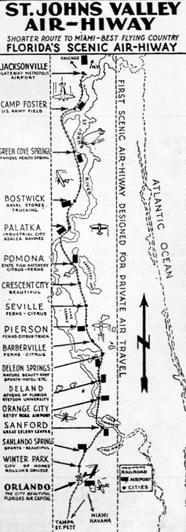
An advertisement from the 1937 Airports Established Landing Fields & Seaplane Bases in the US (courtesy of Brian Rehwinkel) for the “St. Johns Valley Air-Hiway”,
depicting Betsy Ross Airport as one of the airfields along the route.
The 1937 Airports Established Landing Fields & Seaplane Bases in the US (courtesy of Brian Rehwinkel)
described Betsy Ross Airport as having four 2,500' runways, oriented East/West, North/South, Northwest/Southeast, and Northeast/Southwest.
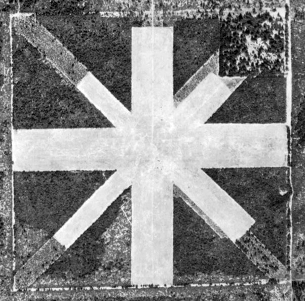
The earliest photo which has been located of Betsy Ross Airport was a 2/19/41 aerial view (courtesy of Brian Rehwinkel).
It depicted the field as having 4 unpaved runways arranged in the cardinal directions.
There were no buildings or aircraft visible on the field.
The last depiction which has been located of Betsy Ross Airport was on the July 1942 Orlando Sectional Chart.
It depicted Betsy Ross as an auxiliary airfield.
According to Richard Moravsik, “The airport didn't last long. It was too costly to maintain.”
Patrick Morris recalled, “My father-in-law is the caretaker of the Hollywood cemetery in Orange City.
He was showing me some aerial photos of the cemetery. In the photos is showed some overgrown, but formerly cleared land west of the cemetery.
My father-in-law told me that there used to be an airport in that area a long time ago.
He told me they military used to do touch & go’s there.”
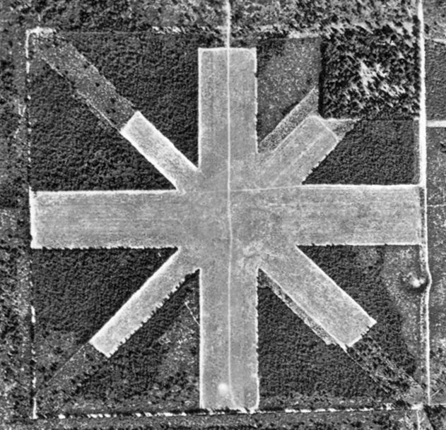
A 1943 aerial view (courtesy of Brian Rehwinkel) depicted Betsy Ross Airport in the same fashion as the 1941 photo.
Betsy Ross Airport was evidently closed during WW2 (like many other small civilian airports near the coasts),
as it was no longer depicted on the July 1944 or February 1944 Orlando Sectional Chart.
Betsy Ross Airport was evidently reopened at some point between 1944-45,
as it was once again depicted on the February 1945 Orlando Sectional Chart.
The 1945 US AAF Airport Directory (courtesy of Brian Rehwinkel)
described Betsy Ross Airport as being a 150 acre irregularly-shaped property having 2 sod runways measuring 2,600' east/west & 2,480' north/south.
It was said to be privately owned, and operated by Volusia County & private interests.
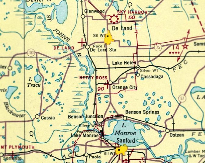
Betsy Ross Airport was evidently renamed De Land Orange Airport at some point in 1945,
as it how it was labeled on the August 1945 Orlando Sectional Chart.
According to Harold Culp, Betsy Ross Airport was maintained until it fell into disuse after World War II.
The last depiction which has been located of De Land Orange City Airport was on the August 1946 Orlando Sectional Chart.
It depicted De Land Orange City as an auxiliary airfield.
De Land Orange City Airport was evidently close (for reasons unknown) as it was no longer depicted on the February 1947 Orlando Sectional Chart.
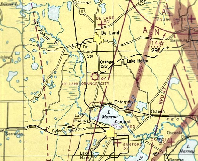
The earliest photo which has been located of the site of De Land Orange City Airport was a 1957 aerial photo.
It depicted 4 former unpaved runways, all intersecting in the center, heavilly overgrown.
The was no indication of any buildings at the site.
A 1994 aerial photo showed a radio tower had been built over the western portion of the airport site.
The remainder of the property had reverted to woods, but traces were still recognizable of portions of the De Land Orange City Airport runways.
A 2019 aerial view of the site of De Land Orange City Airport showed River Springs Middle School occupying the northwest portion,
Manatee Cove Elementary School on the northeast portion, and new streets having been constructed over the southern portion.
No trace of the airport appeared to remain.
According to Richard Moravsik, “Today what remains is a local Middle School,
and a housing development, (Compass Landing) with streets [named] Lady Bird Lane & Jetway.”
Thanks to Patrick Morris for pointing out this airfield.
____________________________________________________
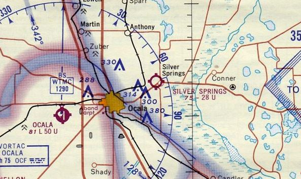
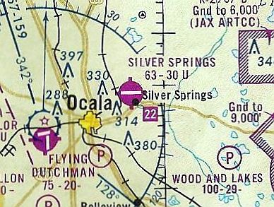
Silver Springs Airpark, Silver Springs, FL
29.22, -82.07 (Northwest of Orlando, FL)
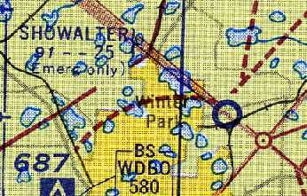
Silver Springs Airpark, as depicted on the August 1947 Orlando Sectional Chart.
David Tooker recalled, “My dad & a friend (who didn't last too long, so he mustn't have been much of one) Ken Richardson, bought the property in 1946 for $60k.”
Silver Springs Airpark was not yet depicted on the February 1947 Orlando Sectional Chart.
The earliest depiction which has been located of Silver Springs Airpark was on the August 1947 Orlando Sectional Chart.
It depicted Silver Springs Airpark as having a 2,600' unpaved runway.
David Tooker recalled, “My dad bought him [airport property co-owner Ken Richardson] out in 1948.
They built the filling station & airport at about the same time.
My dad had a PT-19 that he stunted for a while, then let rot on the taxi strip
(the north/south one - a few guys actually took off on it, but were not supposed to, it was only about 1,600').
I remember one guy in a taildragger took off going south, made it over SS Boulevard & caught his gear in the power lines, flipped & made a great hung-in-the-trees retrieval.
I stepped out of the house we were living in at the time to watch the fire truck get them down with ladders.
He probably would have made the takeoff OK, but had 4 people in the plane, and was over-grossed.
I was about 4 at the time [1949 or 1950], but remember it well... some things stick in your mind.
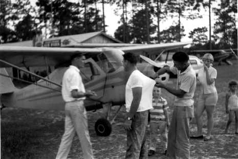
I have a picture of the Silver Springs SkyWay Station, which was either ESSO or Mobile at the time.
Pictured in front with Al Boice's Stinson.”
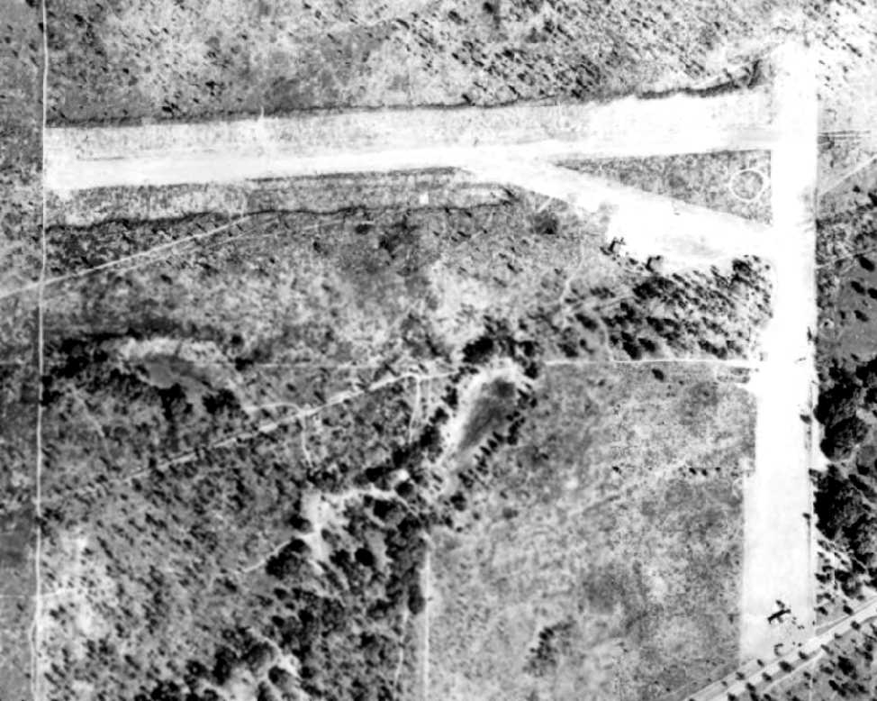
The earliest photo which has been located of Silver Springs Airpark was a 1949 aerial view (from the U of FL Digital Collections).
It depicted Silver Springs Airpark as having 2 unpaved runways, with 2 small buildings southwest of the runway intersection.
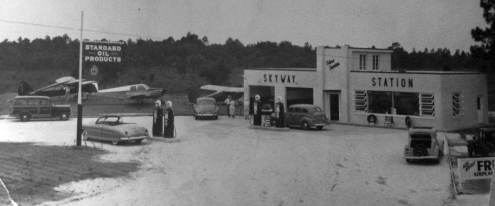
A circa late 1940s photo of 2 taildraggers & a Beech Bonanza at the Skyway Station at the south end of Silver Springs Air Park (courtesy of Alex Nelon).
Alex Nelon noted, “The Hudson convertible was owned by the Air Park owner, Nat Tooker,
and was, in addition to being a pretty zippy car for its day, the favored spot for their cat to give birth to the family's kittens.”
Alex Nelon recalled, “Silver Springs Airpark... was owned at one time by my best friend’s father & had 2 runways, north/south & east/west, both turf.
The operators were John & Pat Henderson.
John had been a civilian instructor during WWII & continued to instruct at Silver Springs.
Their Chesapeake Bay Retriever, Press, used to catch lady-finger firecrackers & let them blow up in his mouth,
sending smoke & spit all over the place to the delight of the airport bums.
Light a newspaper & Press would bite it until the fire was out – it was a story in the Orlando Sentinel a few times: “Fire Eating Dog” or some such.
It was a real human-being airport, populated with some of the most interesting characters:
Johnny Weissmuller ('Tarzan'), Ricou Browning (The Creature in the underwater scenes from the movie 'Creature of the Black Lagoon'),
Chicago radio personality Tommy Bartlett, and old war buddies of the owner, Nat Tooker.”
Gay Kite recalled, “Silver Springs Airpark.. I grew up at the airport.
My father, John Henderson, was the flight instructor & FBO along with my mother from the mid-1950s.”
AirForrest recalled, “Lloyd Bridges used to fly into & out of the Silver Springs [Airpark] while filming 'Sea Hunt' [1958-61] there.”
A 1960 photo (courtesy of Alex Nelon) of a group in front of a taildragger at Silver Springs Airpark.
A 1964 aerial view (from the U of FL Digital Collections) depicted Silver Springs Airpark as having a single unpaved east/west runway,
A building had been added at some point between 1949-64,
and 2 light single-engine aircraft were visible on the southeast side of the runway.
The November 1965 Orlando Sectional Chart depicted Silver Springs Airpark as having a 2,800' unpaved runway.
Steve Sierens recalled, “On highway 40 near Silver Springs was a paved east/west strip that was on the site of 'Six Gun Territory”; a tourist attraction.
I used to fly in there in a Piper J-3 Cub; you could walk to the attraction.”
The 1967 USGS topo map depicted Silver Springs Airport as having a paved east/west runway & a few small buildings on the southeast side.
Silver Springs apparently gained a paved runway at some point between 1965-68,
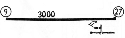
as the 1968 Flight Guide (courtesy of Robert Levittan) depicted it as having a 3,000' paved Runway 9/27,
with taxiway leading to 2 small buildings on the southeast side.
The last aeronautical chart depiction which has been located of Silver Springs Airpark was on a 1972 FL Aeronautical Chart (courtesy of Patrick).
It depicted Silver Springs as having a 3,000' paved east/west runway.
Alex Nelon recalled, “John Henderson... continued to instruct at Silver Springs until the mid to late-1970s when the airport was sold.”
Silver Springs Airport was still depicted on the 1978 USGS topo map.
Gay Kite recalled, “Silver Springs Airpark.. My father, John Henderson, was the flight instructor & FBO along with my mother until 1978-79.
After that airport closed, he was instructing at Jim Taylor Field.”
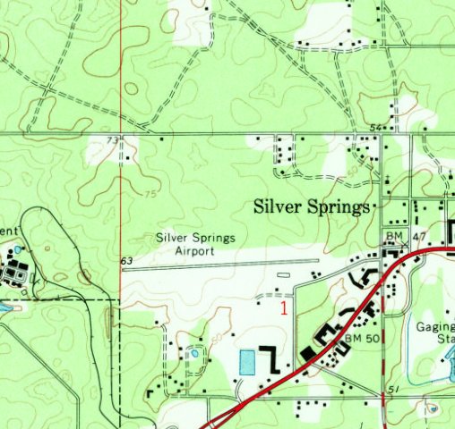
The 1991 USGS topo map depicted a campground on the site of Silver Springs Airpark.
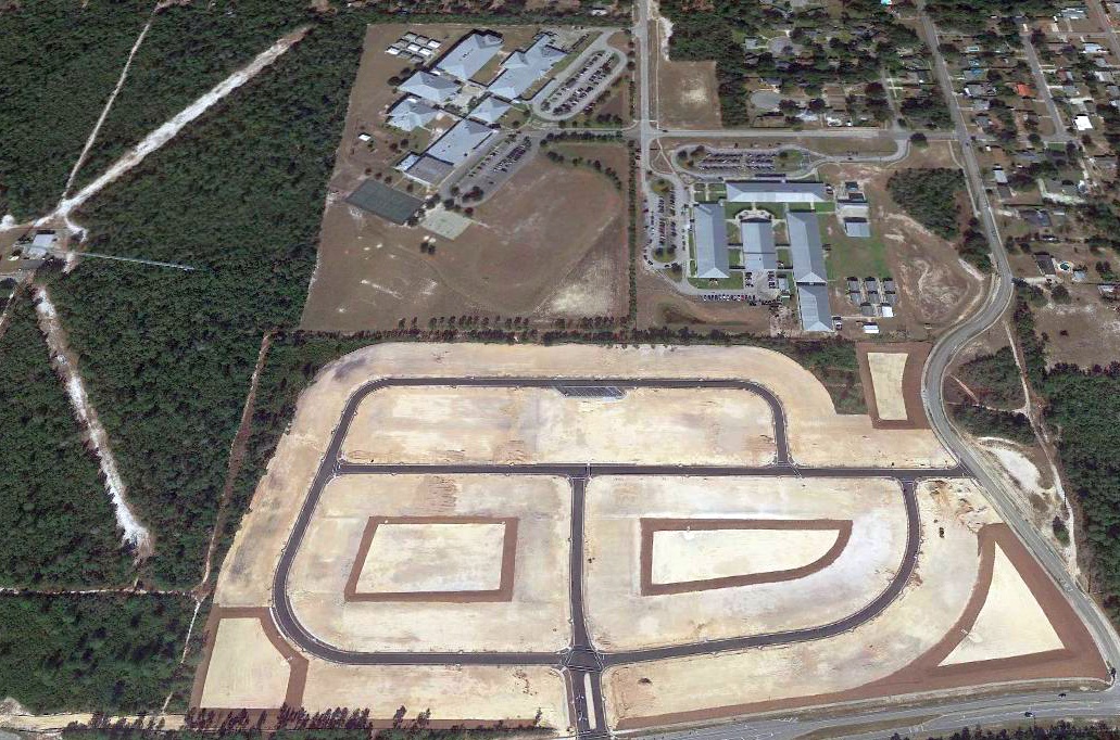
A 1995 USGS aerial photo showed mobile homes around the former airport site, but the western end of the runway remained clear.
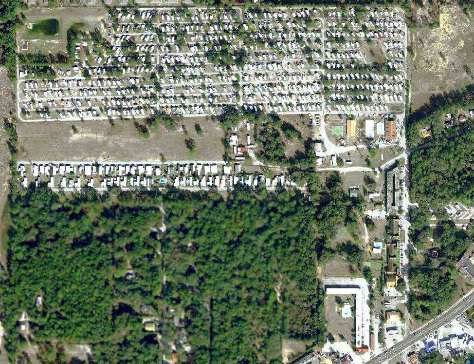
Although surrounded by trailers, a 1/1/08 aerial view showed the western half of the Silver Springs runway remained clear.
Alex Nelon reported in 2008, “The airpark is now covered with mobile homes
and only the concrete block office remains, a shed for maintenance equipment.”
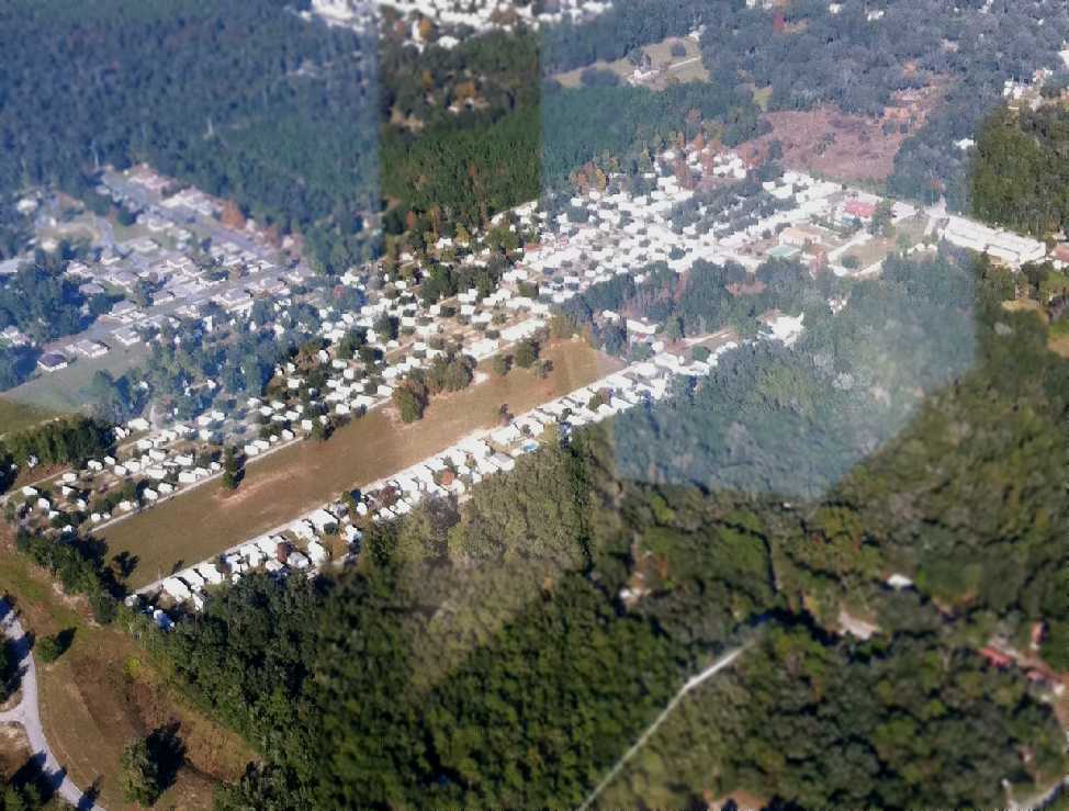
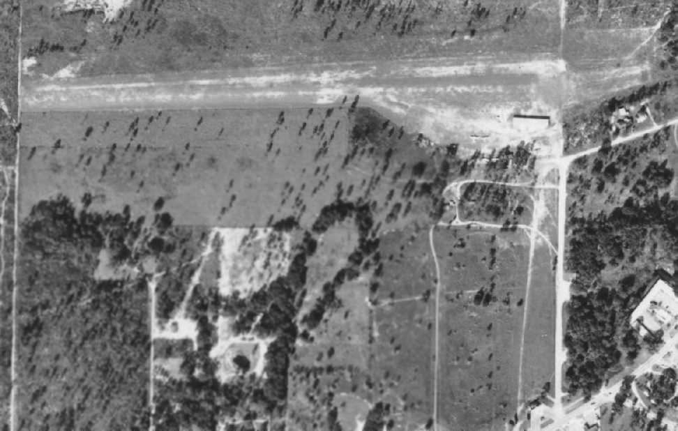
The latest photo which has been located of the site of Silver Springs Airpark was a 11/21/11 aerial view looking northeast by Rocky Driggers.
The outline of the runway remains recognizable.
The site of Silver Springs Airport is located west of the intersection of Northeast 29th Street & Silver Springs Airport Road, appropriately enough.
____________________________________________________
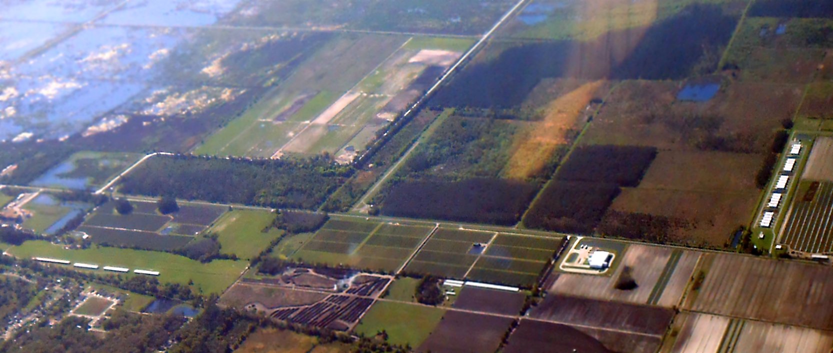
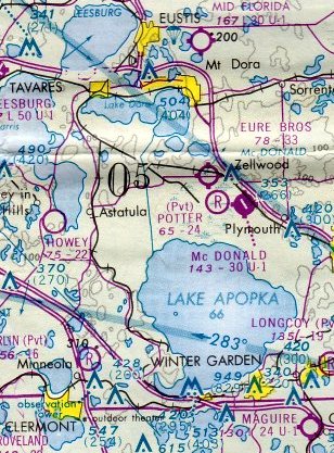
Potter Field / Zellwin Farms Airport, Zellwood, FL
28.73, -81.64 (Northwest of Orlando, FL)
Potter Field, as depicted on the March 1975 Jacksonville Sectional Chart (courtesy of John Ferrara).
Potter Field may have been built at some point between 1970-75,
as it was not yet depicted on a 1969 aerial photo or on the 1970 USGS topo map.
The earliest depiction which has been located of Potter Field was on the March 1975 Jacksonville Sectional Chart (courtesy of John Ferrara).
It depicted Potter Field as a private airfield having a 2,400' unpaved runway.
Richard Surrency recalled, “Potter Field... back in the late 1970s I was taking flying lessons out of Orlando & the instructor & I would stop in there.
On one of the stopovers we walked into this small hangar & on the floor was a aircraft in pieces, a Travel Air.
I asked the guy working on it, who it belonged to. He told us it was the property of Delta Airlines. I was excited because worked for Delta at MCO.
From that day forward, after I soloed I made it a point to stop & see how restoration was going.
On my last stopover he told me the plane was going to be flown the next day to MCO.
That aircraft now is in the Delta museum in Atlanta.”
Potter Field still was not depicted on the 1979 USGS topo map.
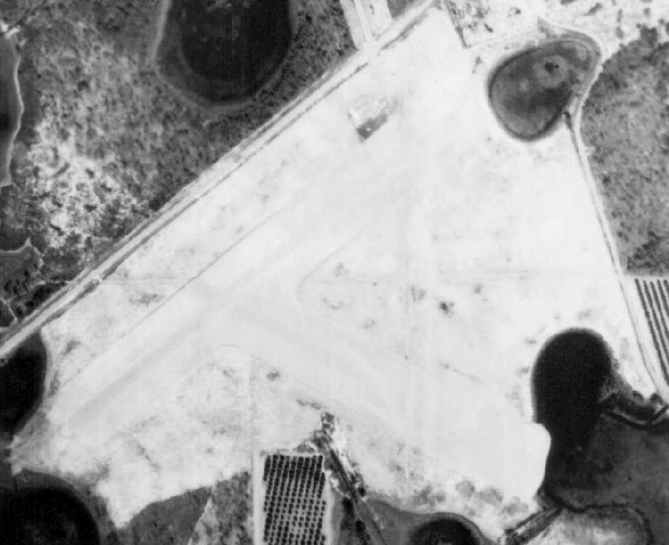
The earliest photo which has been located of Potter Field was a 1980 aerial photo.
It depicted a single paved runway, ramp, and 2 hangars.
No airfield was depicted at this location on the 1985 FL Aeronautical Chart (courtesy of Alex Hauzer).
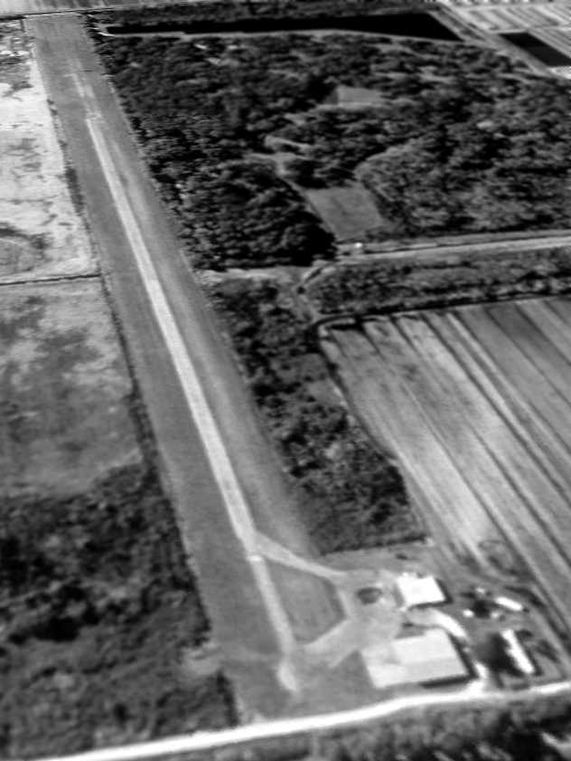
The earliest photo which is available of Potter Field was a 2/5/95 USGS aerial view looking southwest.
It depicted Potter Field as having a single paved runway, ramp, and 2 hangars.
Potter Field also was evidently known as Zellwin Farms Airport.
Matthew Clapp reported, “Zellwin Farms Airport... was a crop dusting airport that was closed when the St. Johns water district purchased the farmland.
This was an attempt to mitigate the pollution that was ending up in Lake Apopka.”
A 1/4/04 aerial view depicted Zellwin Farms Airport to remain completely intact.
A 5/28/05 aerial view showed that the northern hangar had been removed at some point in the previous year.
A circa 2005-2010 photo looking south at Zellwin Farms Airport,showing the paved runway, ramp, and hangar, all looking abandoned yet intact.
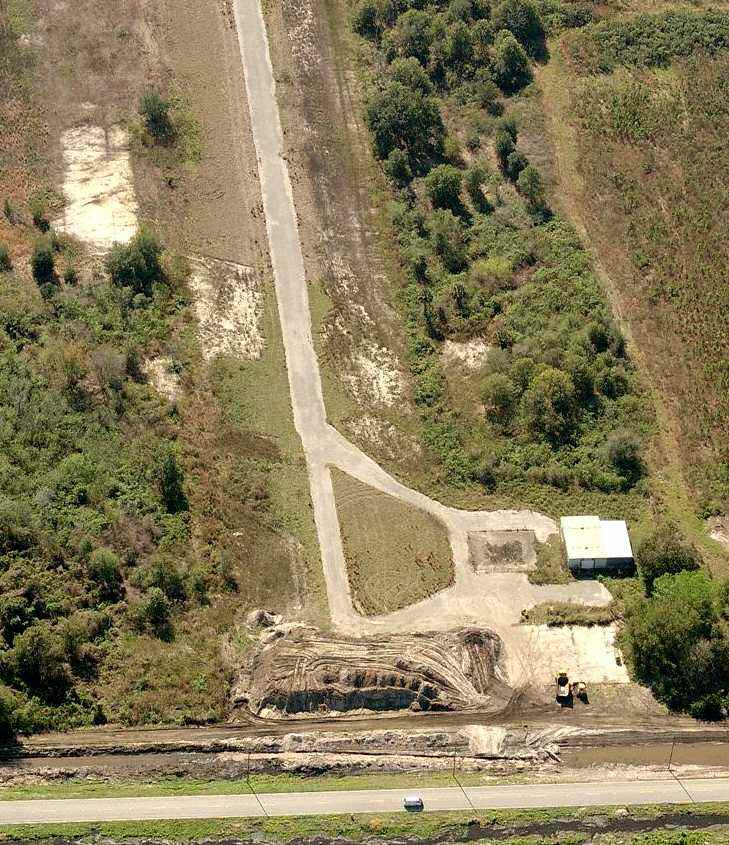
A circa 2005-2010 aerial view looking south at Zellwin Farms Airport,showing the paved runway, ramp, and hangar,
with some earthmoving in progress at the northern end of the runway.
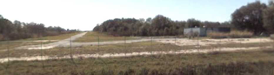
Tony Air reported in 2007, “It's pretty rural out there, and the abandoned airport is still there. Fenced off though.
It has a paved north/south runway with an apron on the northwest side of the airport, and what I think is a hangar.
The runway looked small in width, a little bigger than lane on a street.
We went to White Field, a public grass airport right around that abandoned airport. We asked around & these folks explained most of it.
They told me it was a private agricultural airstrip used by one man, Potters.
That man sold the airport to the state & the state fenced it off for some reason.
It [is] listed it as Zellwin Farms on Google Earth. But then the people told me it was Potters Field.”
Zellwin Farms Airport was depicted as an abandoned airfield on the 2011 Jacksonville Sectional Chart.
A 2016 aerial view looking southwest at Zellwin Farms Airport showed the paved runway, ramp, and hangar remaining intact.
A 3/3/18 aerial view by Alex Price looking southeast at Zellwin Farms Airport (center of photo).
It also shows the nearby Bob White Airfield (bottom-left) & Orlando North Airpark (right side).
Zellwin Farms Airport is located southwest of the intersection of Jones Avenue & Jewel Foliage Road.
____________________________________________________
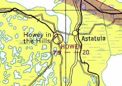
Howey Airport, Howey in the Hills, FL
28.7, -81.77 (Northwest of Orlando, FL)
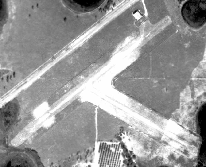
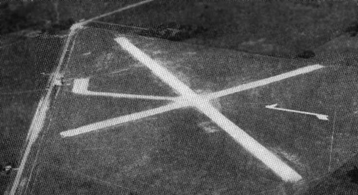
A 2/1/47 aerial view of Howey Airport (from the U of FL Digital Collections).
This small general aviation airport was evidently established at some point between 1946-47,
as it was not yet depicted on the August 1946 Orlando Sectional Chart (courtesy of Ron Plante).
The earliest depiction which has been located of Howey in the Hills Airport
was a 2/1/47 aerial view of Howey Airport (from the U of FL Digital Collections).
It depicted Howey as having 2 runways, with a single hangar on the north side.
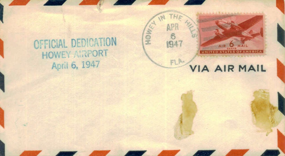
A postmark commemorated the 4/6/47 Dedication of Howey Airport.
The earliest aeronautical chart depiction of the field which has been located
was on the February 1949 Orlando Sectional Chart (courtesy of Chris Kennedy),
which described "Howey" as having a 2,000' unpaved runway.
A 1/11/58 USDA aerial photo of Howey Airport (via the FL Department of Transportation, courtesy of Brian Rehwinkel)
showed the field as having 2 unpaved runways, with a ramp & a single hangar at the northeast corner.
The Aerodromes table on the 1964 Orlando Sectional Chart (according to Chris Kennedy)
described the field as having 2 runways, with the longest being a 2,000' turf strip,
but the remarks said "Northwest/Southeast runway permanently closed."
The November 1965 Orlando Sectional Chart (courtesy of Ron Kunse) depicted Howey Airport as having a 2,000' unpaved runway.
The Aerodromes table on the 1966 Orlando Sectional Chart (according to Chris Kennedy)
described the field as having a single 1,850' bare runway.
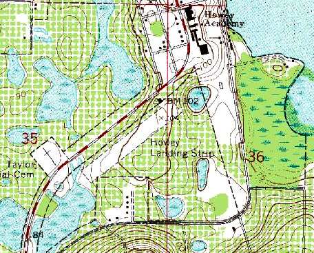
The 1969 USGS topo map depicted the "Howey Landing Strip" as having a single northeast/southwest unpaved runway,
with a single hangar on the northeast corner of the field.
The former crosswind runway was no longer depicted.
Howey was listed in the "Low Use" section of the 1971 Flight Guide (according to Chris Kennedy),
as was described as having a single 1,800' unpaved Runway 4/22.
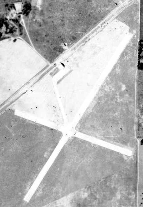
A 2/10/74 aerial view of Howey Airport (from the U of FL Digital Collections)
depicted the field as having a single grass northwest/southeast runway, with the hangar at the north end.
There was no longer any sign of the former crosswind runway,
the land having been returned to cultivation.
The last aeronautical chart depiction which is available of Howey Airport was on the March 1975 Orlando Sectional Chart (courtesy of John Ferrara).
It depicted Howey as having a 2,200' unpaved runway.
It was depicted as "Howey Airport" on the 1978 & 1979 USGS topo maps.
Howey was listed as a private field in the 1980 AOPA Airports USA directory (according to Chris Kennedy).
Howey Airport was evidently abandoned (for reasons unknown) at some point between 1980-82,
as it was no longer listed at all in the 1982 AOPA Airports USA directory (according to Chris Kennedy).
It was depicted as "Howey Landing Strip" on the 1985 USGS topo map.
Howey Airport was no longer depicted at all on the 1998 World Aeronautical Chart.
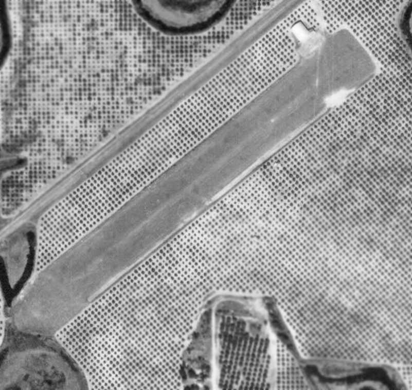
The 1999 USGS aerial photo showed that the airfield consisted of a single 2,400' runway, oriented northeast/southwest.
The single hangar sat at the northeast end of the runway.
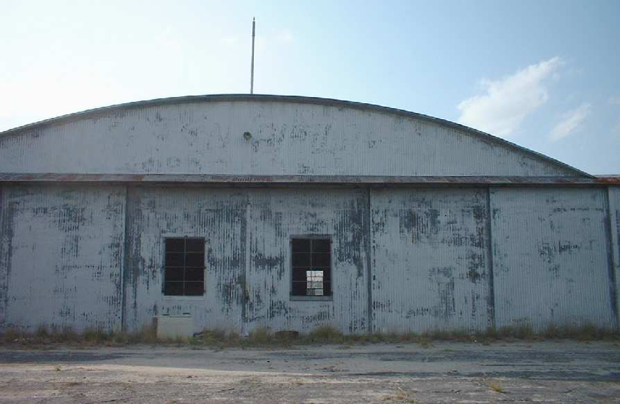
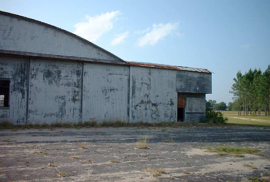
Two 2003 views by Robert Murphy of the remaining hangar at Howey Airport.
Robert Murphy "stumbled across" this former airfield in 2003.
"I was actually looking for abandoned buildings to photograph when I came across what I thought was an old warehouse,
but upon later inspection, it is an old hangar.
The sign scars on the side of the building say something like 'GREEN AIRWAYS',
'HOWEY-IN-THE-HILLS' (that's the name of the town, believe it or not).
It didn't cross my mind that this was an old airstrip,
but I believe the area that looks to be the former runway was all low brush."
A 2004 aerial view looking south at the remains of Howey Airfield showed the outline of the former northeast/southwest runway, along with the single hangar.
Douglas Wilson reported in 2005 that a recent visit showed the Howey Airport property to be for sale.
“According to my latest information, the hangar has been bulldozed.”
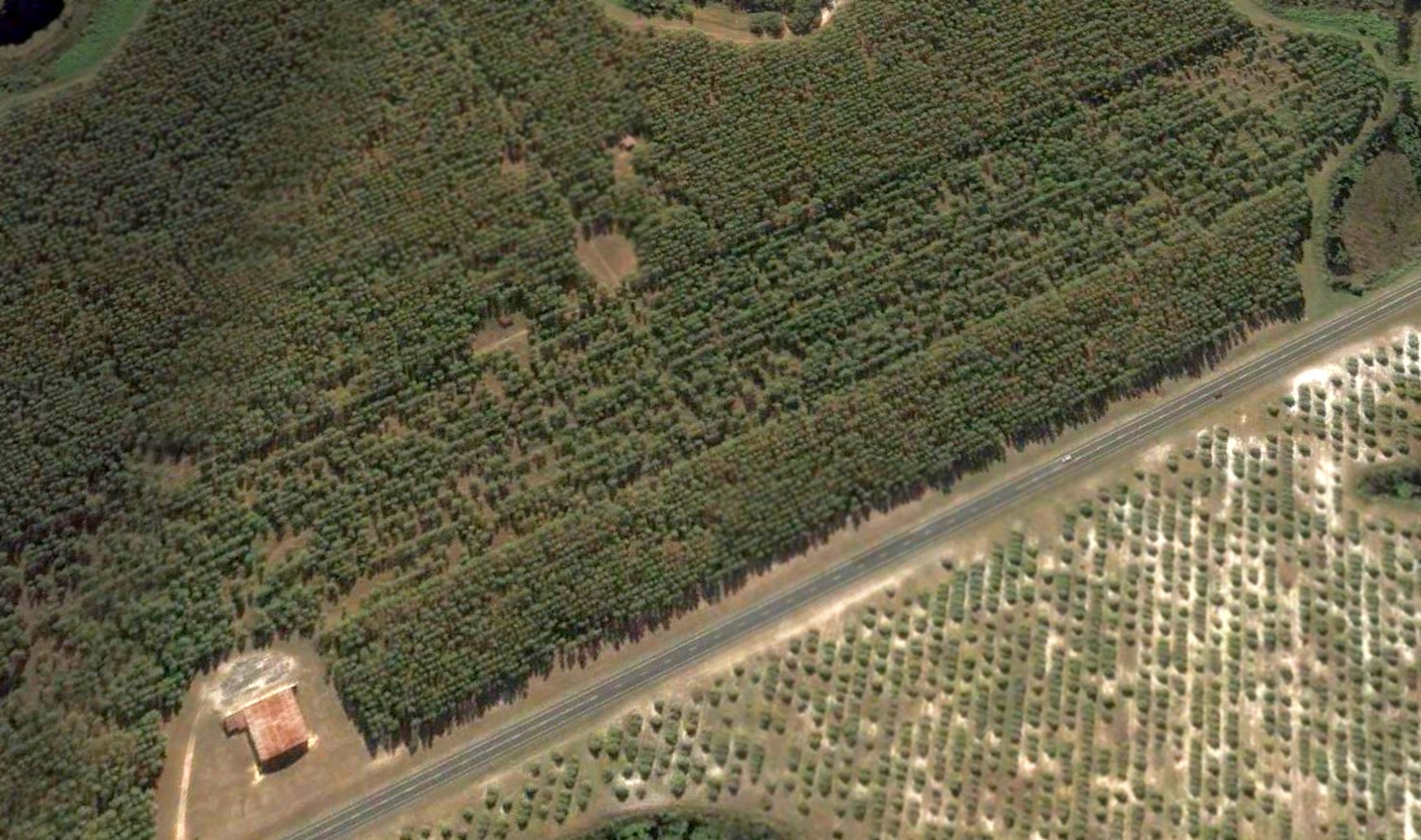
A 2005 aerial photo showed the hangar had been removed at some point between 2004-2005, but the runway remained not yet redeveloped.
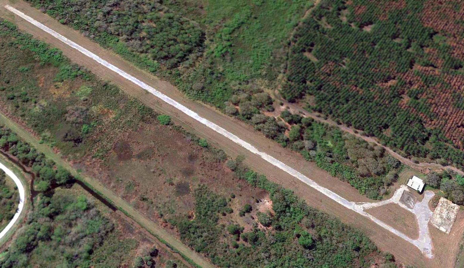
Indeed a 2008 aerial view by Bob, looking northeast, shows that the runway & hangar of the Howey In The Hills Airport have been completely removed -
another bit of local aviation history wiped away by “development”.
Howey Airport is located south of the intersection of Route 19 & South Florida Avenue.
____________________________________________________
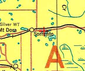
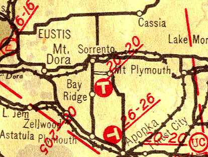
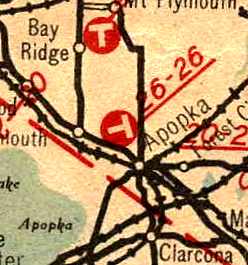
Mt. Plymouth Airport, Mt. Plymouth, FL
28.79, -81.53 (Northwest of Orlando, FL)
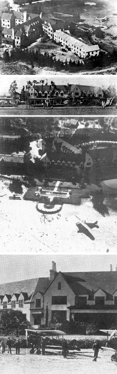
A series of undated photos showing aircraft parked next to the Mt. Plymouth Hotel.
According to the website of the Florida Central Academy, the 150-room Mount Plymouth Hotel was opened in 1926.
The hotel was built at a cost of $350,000, and was the centerpiece of a golfing resort.
At some point between 1926-35, an airfield was established directly adjacent to the hotel building, and it was used by hotel guests to fly in & out of the resort.
The earliest depiction which has been located of the Mt. Plymouth Airfield was on the 1935 Orlando Sectional Chart,
which depicted it as an unnamed auxiliary airfield.
The November 1936 "Official Airway Map of FL" (courtesy of Chris Kennedy)
depicted an airfield just to the southwest of Mt Plymouth.
This location is somewhat different from that depicted on the 1935 chart, but was presumably the same field.
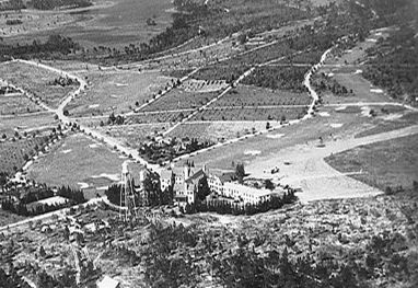
A circa 1930s aerial view of the Mt. Plymouth Hotel, showing the airfield extending toward the right.
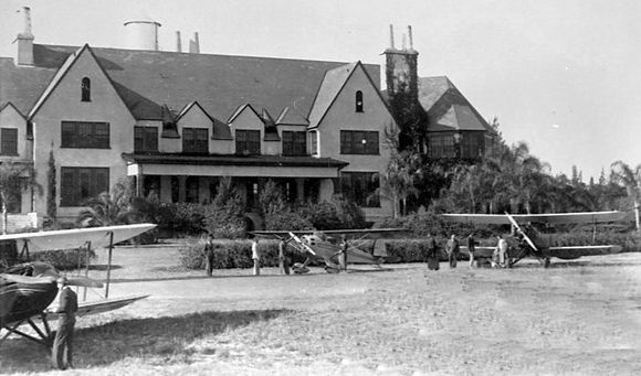
A circa 1930s view of 2 unidentified biplanes & a monoplane in front of the Mt. Plymouth Hotel.
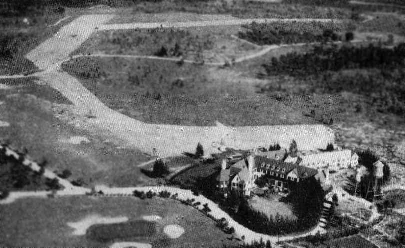
An aerial view of the Mt. Plymouth Airport,
from the Airport Directory Company's 1937 Airports Directory (courtesy of Bob Rambo).
The directory described Mt. Plymouth as an auxiliary airfield,
having two 2,000' runways, oriented north/south & east/west in a T-shape.
The aerial photo in the directory depicted the Mt. Plymouth directly adjacent to the runways.
The last aeronautical chart depiction which has been located of the Mt. Plymouth Airfield was on the August 1940 Orlando Sectional Chart,
which depicted it as an auxiliary airfield.
A 1941 USDA aerial photo of the Mt Plymouth Airport (courtesy of the FL DOT via Brian Rehwinkel).
Although the north/south & northwest/southeast runways were still clear,
there was no indication that the field was still in use as an airport.
The Mt. Plymouth Airport was evidently closed at some point between 1940-42,
as it was no longer depicted at all on the January 1942 Orlando Sectional Chart (according to Chris Kennedy),
nor listed in the 4/1/44 US Army/Navy Directory of Airfields (courtesy of Ken Mercer).
A 1947 aerial photo showed the north/south & northwest/southeast runways were still clear,
but there was no indication that the field was still in use as an airport.
Starting in 1959, the former Mt. Plymouth Hotel was reused as the location of the Florida Central Academy.
In its heyday, it was considered one of the finest college preparatory boarding schools in the United States.
A 1969 aerial photo showed the north/south & northwest/southeast runways were still clear.
In 1983 the Mt. Plymouth property became the custody of the U.S. Bankruptcy Court,
which ordered the Florida Central Academy school closed & all business transactions halted pending the settling of claims.
Four days later county health officials condemned the building as unfit for human habitation.
The building quickly fell prey to vandals.
Plumbing was ripped out, walls bashed in, windows broken & graffiti painted on the walls.
Then in 1986, two 3-story wings of the former hotel were destroyed in a fire set by 2 teenagers.
One year later, in 1987, fire destroyed the remaining South Wing, in yet another episode of arson.
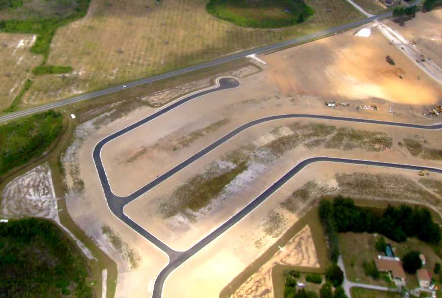
As seen in the 1999 USGS aerial photo,
the former north/south runway has been covered with a housing development.
It is believed that the clearing running northwest/southeast (just above the center of the photo)
is the remaining outline of one of the former runways.
The site of the hotel is at the west end of that runway (at the northwest corner of the photo).
A later aerial photo shows that the additional portions of the former airfield have been covered by housing as well.
The site of the Mt. Plymouth Airport is located southeast of the intersection of Westchester Avenue & Timuquana Avenue.
Thanks to Charles "Sandy" Jordan for pointing out the location of this airfield.
____________________________________________________
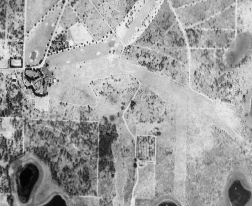
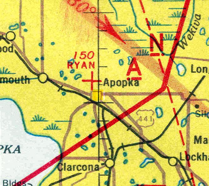
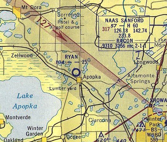
Ryan Municipal Airport, Apopka, FL
28.69, -81.51 (Northwest of Orlando, FL)
Ryan Field, as depicted on the November 1936 "Official Airway Map of FL" (courtesy of Chris Kennedy).
Ryan Municipal Airport was evidently established at some point between 1935-36,
as it was not yet depicted on the 1935 Orlando Sectional Chart.
The earliest depiction which has been located of Ryan Municipal Airport
was on the November 1936 "Official Airway Map of FL" (courtesy of Chris Kennedy).
It depicted the field as having 2 runways in the shape of a "T".
According to the Apopka Historical Trail web site (courtesy of Brian Rehwinkel),
Helen McBride leased the Ryan Municipal Airport starting in 1942 to teach military pilots to fly in her four airplanes.
McBride had received her pilot's license in the mid-1930s, and was a former cross-country air racer.
The January 1942 Orlando Sectional Chart (courtesy of Chris Kennedy) depicted Ryan as an auxiliary airfield.
The earliest directory listing of Ryan Field which has been located
was in the 4/1/44 US Army/Navy Directory of Airfields (courtesy of Ken Mercer).
It described Ryan as having a 2,800' unpaved runway.
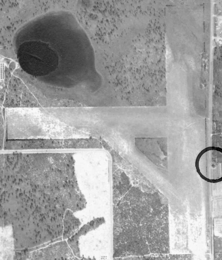
A 2/21/47 aerial photo of Ryan Field (from the FL DOT, courtesy of Brian Rehwinkel)
depicted Ryan Field as having 2 runways, oriented north/south & east/west.
It did not seem to depict any buildings at the airport, though.
The runways of Ryan Field were depicted on an August 1950 FL Department of Transportation street map (courtesy of Brian Rehwinkel),
but the airport was not labeled.
The last aeronautical chart depiction which has been located of Ryan Municipal Airport was on the 1952 Orlando Sectional Chart.
It depicted Ryan as having a 2,500' unpaved runway.
According to the Apopka Historical Trail web site (courtesy of Brian Rehwinkel), Helen McBride's lease at Ryan Municipal Airport ended in 1952.
A portion of the airport on the northwest corner of Park Avenue & Summit Drive was sold in 1954 to the Orange County School Board,
and the Dream Lake Elementary School opened the following year.
By the time of the August 1954 Orlando Sectional Chart (according to Chris Kennedy), Ryan Field was no longer depicted.
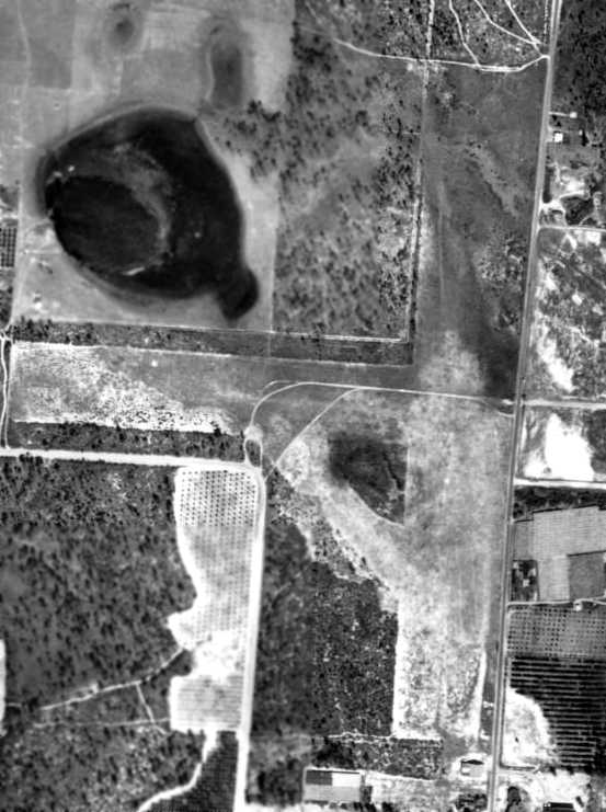
The last photo which has been located of Ryan Municipal Airport was a 3/1/54 aerial view (from the U of FL Digital Collections).
It depicted the field as remaining intact, but evidently abandoned.
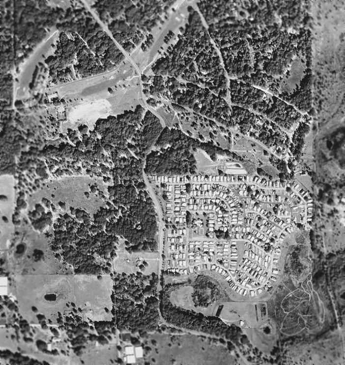
A 1969 aerial photo showed that houses had covered the site of Ryan Airport at some point between 1954-69.
As seen in a 2024 aerial photo, the site of Ryan Field has been densely redeveloped, with not a trace appearing to remain of the former airport.
____________________________________________________
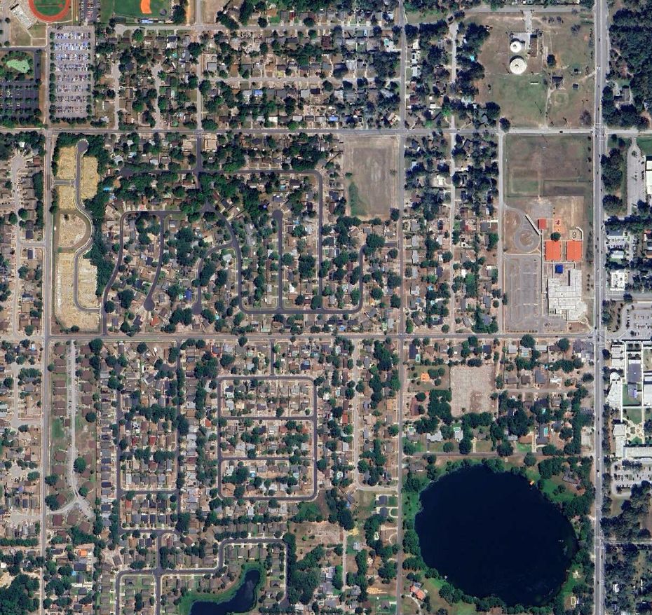
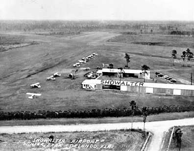
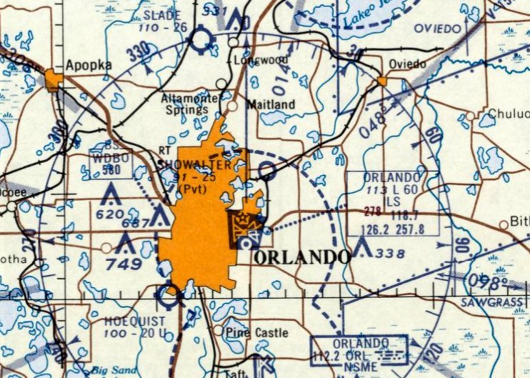
Showalter Airpark, Winter Park, FL
28.6, -81.32 (Northeast of Orlando, FL)
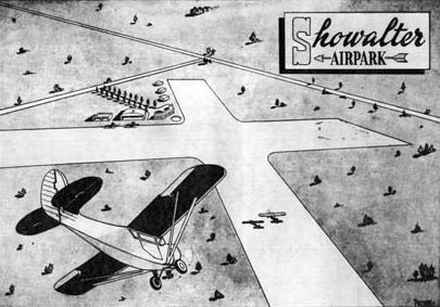
A circa 1940s artist's conception of the planned Showalter Airpark (from the Winter Park Public Library, courtesy of Dallam Oliver-Lee).
A 4/10/40 USDA aerial photo (courtesy of Dallam Oliver-Lee)
did not yet depict any airfield on what would eventually become the site of Showalter Airpark.
As described on the current Showalter Flying Service web site,
Howard & "Sandy" Showalter & "Buck" Rogers migrated to Florida in late 1945 after completing their military service,
acquired 100 acres of ground in Winter Park, and built Showalter Airpark.
The Airpark was intended to be the mecca for the private pilot
with a country club atmosphere to make flying attractive to everyone.
With the advent of the G. I. Bill, flight training became a large part of the operation
and the fleet was increased to 3 J-3 Cubs, a Luscomb Silvaire, a Taylorcraft and a Fairchild-24.
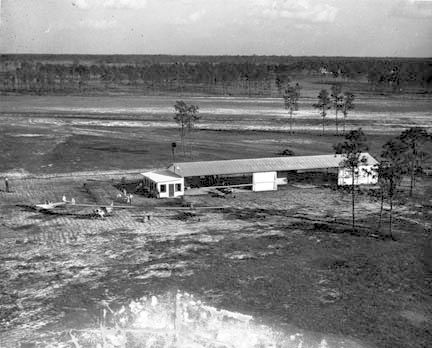
The earliest photo which has been located of Showalter Airpark
was a 1946 aerial view showing a hangar with attached office, and 4 single-engine planes (from the Winter Park Public Library, courtesy of Dallam Oliver-Lee).
The August 1946 Orlando Sectional Chart did not yet depict Showalter Airport.
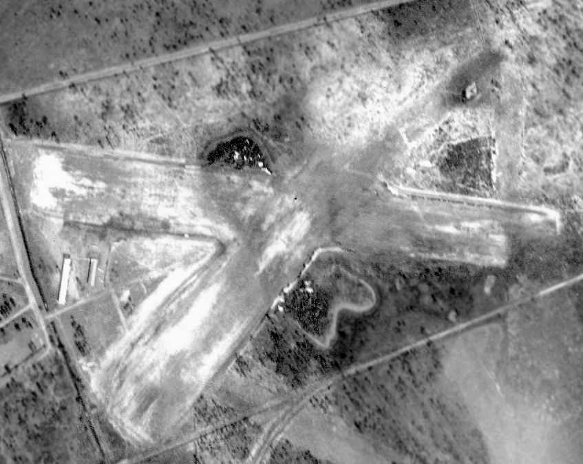
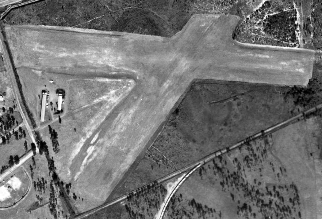
A 3/17/47 aerial photo (from the FL DOT, courtesy of Brian Rehwinkel)
depicted Showalter Airpark as having 2 grass runways, oriented east/west & northeast/southwest,
and 2 hangars west of the runway intersection.
No aircraft were visible on the field.
An undated view of Showalter Airport.

Howard Showalter, Ford Rogers Jr., and Sandy Showalter.
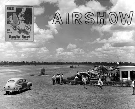
A photo & advertisement for a June 1948 Airshow at Showalter Airpark (from the Winter Park Public Library, courtesy of Dallam Oliver-Lee).
The 1949 Orlando Sectional Chart (courtesy of Chris Kennedy)
described Showalter Airport as having a 2,500' unpaved runway.
The Showalter company was expanded to include a flight school at Sanford
and one at Herndon (then the Orlando Municipal Airport).
The original Showalter Airpark was becoming a smaller part of the company's business,
as the growing number of corporate pilots needed an airport with better facilities,
navigation systems & capacity to handle the larger aircraft.
Therefore, when the new terminal was built on Orlando Municipal Airport in 1951,
the Showalter Corporation was the successful bidder to initiate the first Fixed Base Operation on the Municipal Airport.
A 3/17/52 USGS aerial photo (courtesy of Dallam Oliver-Lee)
depicted 2 light aircraft parked north of Showalter's hangars.
A 3/1/54 USDA aerial photo (courtesy of Dallam Oliver-Lee) did not depict any aircraft at Showalter.
The 1956 USGS topo map depicted Showalter Airpark as having 2 unpaved runways & 2 small buildings on the west side.
By the time of the 1957 Orlando Sectional Chart (courtesy of Chris Kennedy),
Showalter Airport was still depicted as an active airfield, but it was also labeled "Emerg only".
The last photo which has been located of Showalter Airpark was a 12/1357 aerial view (courtesy of Dallam Oliver-Lee).
It depicted one single-engine aircraft parked on the north side of the hangars.
According to Bob Showalter, "We had moved our main business to the downtown Orlando Airport by 1959."
An early 1960s FL Department of Transportation street map (courtesy of Brian Rehwinkel)
depicted Showalter Airport as having two 2,500' runways, oriented east/west & northeast/southwest.
The last aeronautical chart depiction which has been located of Showalter Airpark was on the February 1961 Orlando Sectional Chart.
It depicted Showalter as a private airfield having a 2,500' unpaved runway.
By the time of the 1962 AOPA Airport Directory, Showalter Airport was obviously on its way out,
as the directory said that the field was unattended, and for "Emergency use only."
It was described as having a single 2,500' turf Runway 9/27.
According to Bob Showalter, "The last plane landed at Showalter Airpark, with me on board with my Dad, in 1963.
We sold the property to a condominium developer."
By the time of the April 1965 Orlando Sectional Chart, Showalter Airpark was no longer depicted.
A 1969 aerial photo showed that houses had covered the site of Showalter Airpark.
A 1/22/13 aerial photo (courtesy of Dallam Oliver-Lee) showed the Showalter Airport property has been densely redeveloped,
and not a trace remains of the former airfield.
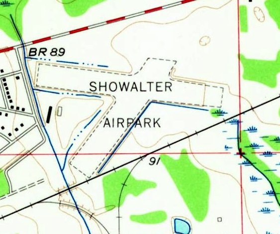
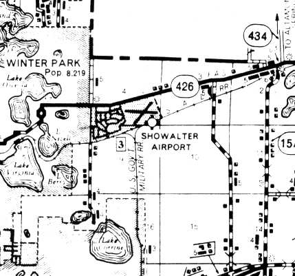
The site of Showalter Airpark is located south of the intersection of Aloma Avenue & Balfour Drive.
Showalter Flying Service continues in business today at the Orlando Executive Airport.
____________________________________________________
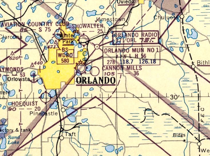
Cannon Mills Airport, Orlando, FL
28.54, -81.3 (East of Orlando Executive Airport, FL)
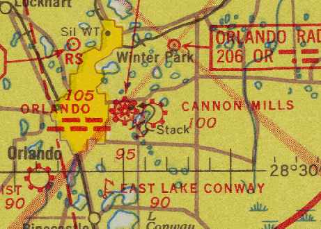
Cannon Mills Airport, as depicted on the January 1942 Orlando Sectional Chart (courtesy of Chris Kennedy).
Cannon Mills Airport was located just east of Orlando Municipal Airport (now Orlando Executive Airport).
Cannon Mills Airport was evidently built between 1940-41,
as it was not yet depicted on the August 1940 Orlando Sectional Chart.
The earliest reference which has been located to Cannon Mills Airport
was in the Airport Directory Company's 1941 Airports Directory (courtesy of Chris Kennedy).
It described Cannon Mills as a commercial airport, consisting of 2 sod runways (3,000' east/west & 2,600' north/south) & a hangar.
The earliest depiction of Cannon Mills Airport which has been located
was on the January 1942 Orlando Sectional Chart (courtesy of Chris Kennedy).
The 4/1/44 US Army/Navy Directory of Airfields (courtesy of Ken Mercer) described Cannon Mills Airport as having a 4,100' unpaved runway.
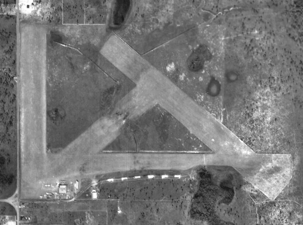
The earliest photo which has been located of Cannon Mills Airport was a 2/23/47 USDA aerial photo (courtesy of Dallam Oliver-Lee).
It depicted a total of 4 unpaved runways, along with about a half-dozen planes parked around a few small buildings at the southwest corner of the field.
Dick McLean recalled, “One of my early memories was going to an airshow at Cannon Mills in 1947 or 1948.
That may have been the last hurrah for Cannon Mills.
Olin Longcoy had a small duster operation there & moved to Ocoee just before Cannon Mills closed.”
The last photo which has been located showing Cannon Mills Airport still intact was a 12/1/49 USGS aerial photo (courtesy of Dallam Oliver-Lee).
The airport may have already been closed by this point, as the ramp was empty – devoid of planes compared to the 1947 photo.
The last aeronautical chart depiction which has been located of Cannon Mills Airport was on the February 1951 Orlando Sectional Chart.
It depicted Cannon Mills as having a 3,600' unpaved runway.
Cannon Mills Airport was evidently closed at some point between 1951-52,
as it was no longer depicted on the February 1952 Orlando Sectional Chart.
A 3/17/52 USGS aerial photo (courtesy of Dallam Oliver-Lee) showed that new residential streets had been built over the southwestern portion of Cannon Mills Airport.
A 3/1/54 USGS aerial photo (courtesy of Dallam Oliver-Lee) showed housing had erased any trace of Cannon Mills Airport.
Even though the field was apparently already closed, Cannon Mills Airport continued to be depicted
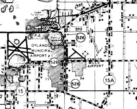
on a FL Department of Transportation street map thought to be from the early 1960s (courtesy of Brian Rehwinkel).
It depicted Cannon Mills Airport as having 3 runways, with the longest being a 3,300' east/west strip.
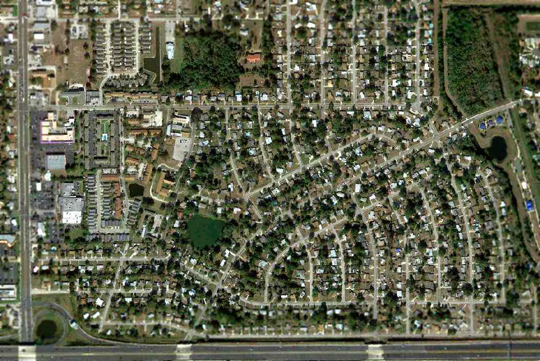
A 1/3/12 aerial photo showed the property of Cannon Mills Airport has been densely redeveloped as the Azelea Park neighborhood,
and not a trace appears to remain of the former airfield.
The site of Cannon Mills Airport is located northeast of the intersection of East/West Expressway & Route 436.
____________________________________________________
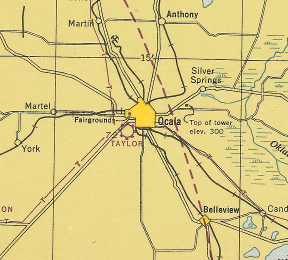
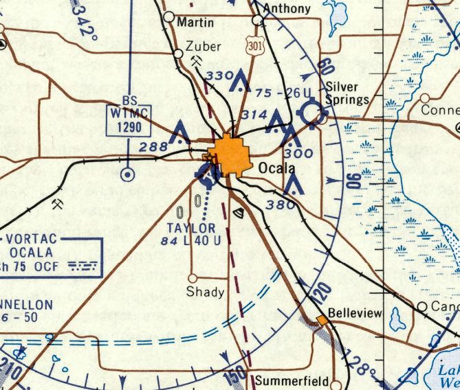
29.18, -82.15 (Northwest of Orlando, FL)
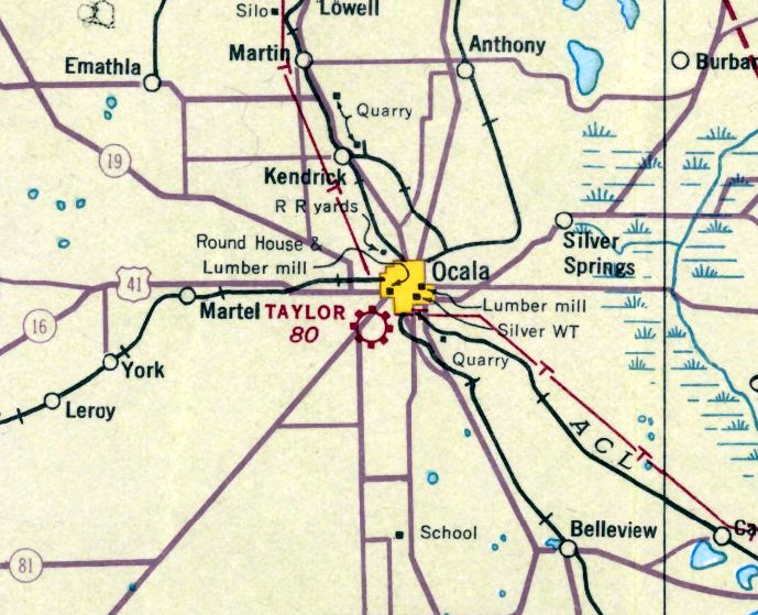
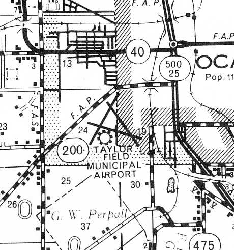
Taylor Field, as depicted on the 1935 Orlando Sectional Chart.
According to a history of the 57th AAF Flying Training detachment (courtesy of the Air Force Historical Research Agency, via Brian Rehwinkel),
prominent local citizen James Taylor donated 167 acres of land in 1929 for the building of an airfield.
The land was cleared & grassed in 1929-30 & the resulting airfield was named Taylor Field.
The Airport Directory Company's 1933 Airports Directory (courtesy of Chris Kennedy)
described Taylor Field as a municipal airport, consisting of 170 acres.
The landing area was said to be a triangular sandy loam field, measuring 4,400' northeast/southwest by 2,100' northwest/southeast.
The earliest depiction which has been located of Taylor Field was on the 1935 Orlando Sectional Chart,
which depicted "Taylor" as a commercial/municipal airport.
The earliest photo which has been located of Taylor Field was an undated aerial view looking east
from The Airport Directory Company's 1937 Airports Directory (courtesy of Bob Rambo).
The directory depicted Taylor Field as having 2 paved runways, with the longest being the 3,900' northeast/southwest strip.
A paved taxiway led to a paved ramp on the north side of the field.
A 2/26/40 aerial view of Taylor Field (from the U of FL Digital Collections)
depicted the field as having 2 paved runways, with a paved ramp leading to a hangar on the north side.
According to the FL Department of State, the Greenville Aviation School opened in November 1941
as a primary flight training facility, located at Ocala's Taylor Field.
The school's owner, Frank Hanley, had moved this facility from Greenville MS while retaining the name of that location for his FL school.
West Point Cadets made up the first class to arrive at the school in November 1941.
Using the Stearman-designed Kaydet PT-17 trainer, over 5,000 cadets received primary flight training at Taylor Field.
With a monthly payroll of $50,000, the Greenville School made a significant economic contribution to the Ocala Community.
According to Brian Rehwinkel, “By 1941, the airport consisted of two 4,000’x150' runways on 400 acres of land.
After the Greenville Aviation School received a contract to train pilots at Taylor Field, additional facilities, and another runway & 2 more hangars were among the additions.
Taylor Field also had 5 auxiliary fields: Futch Auxiliary Field, County Auxiliary Field, Canal Auxiliary Field, Morriston Auxiliary Field, and Kendrick Auxiliary Field.
Most were in close proximity to Taylor Field.
Taylor Field was depicted as a municipal/commercial field on the January 1942 Orlando Sectional Chart (courtesy of Chris Kennedy),
although with the comment “Restricted to Air Corps Training.”
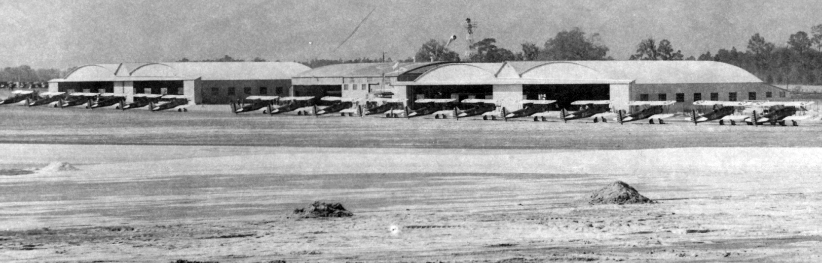
A circa 1942 photo looking west at a row of USAAC biplanes (model unidentified) in front of the Taylor Field hangars (courtesy of the Air Force Historical Research Agency, via Brian Rehwinkel).
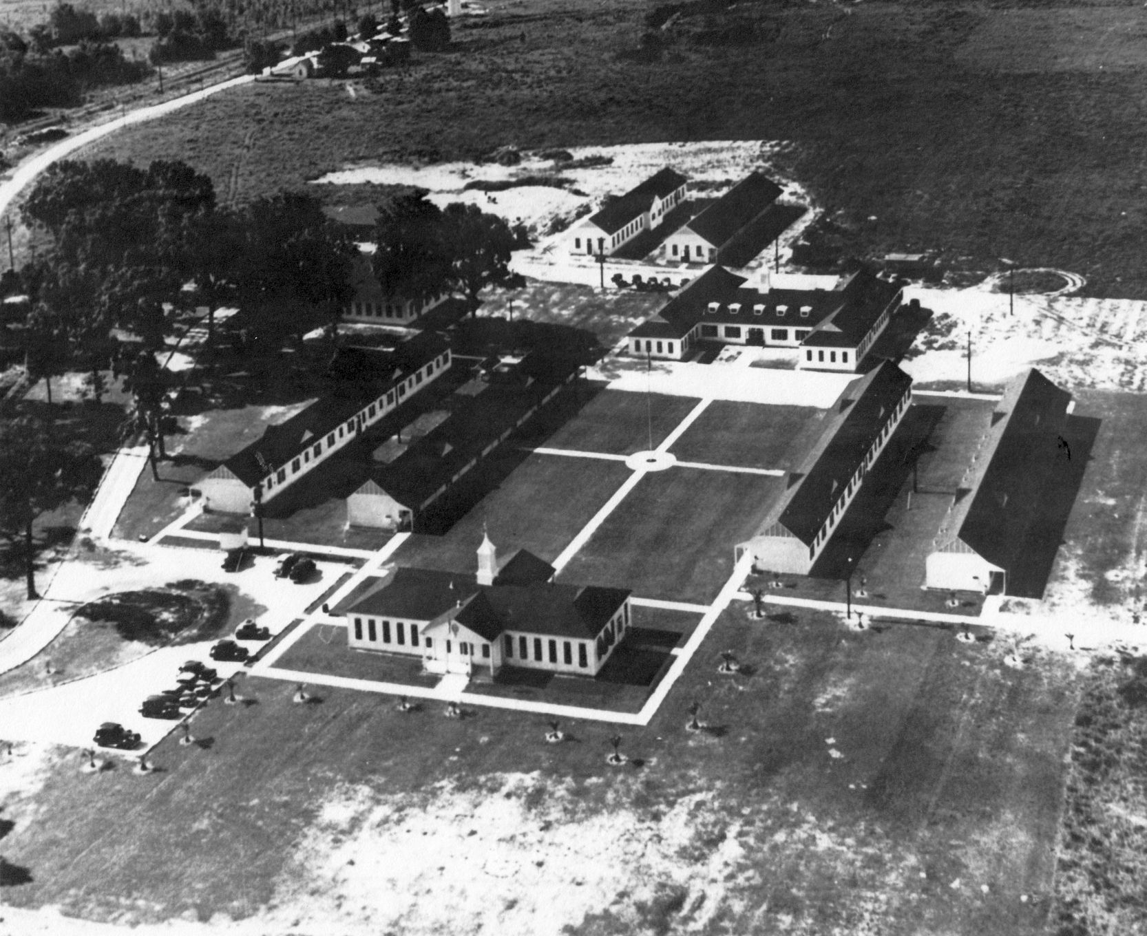
A circa 1942 photo looking south at the Greenville Aviation School buildings on the northeast side of Taylor Field (courtesy of the Air Force Historical Research Agency, via Brian Rehwinkel).
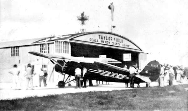
A Stinson "S" Junior in front of the hangar at Taylor Field in 1943 (courtesy of Brian Rehwinkel).
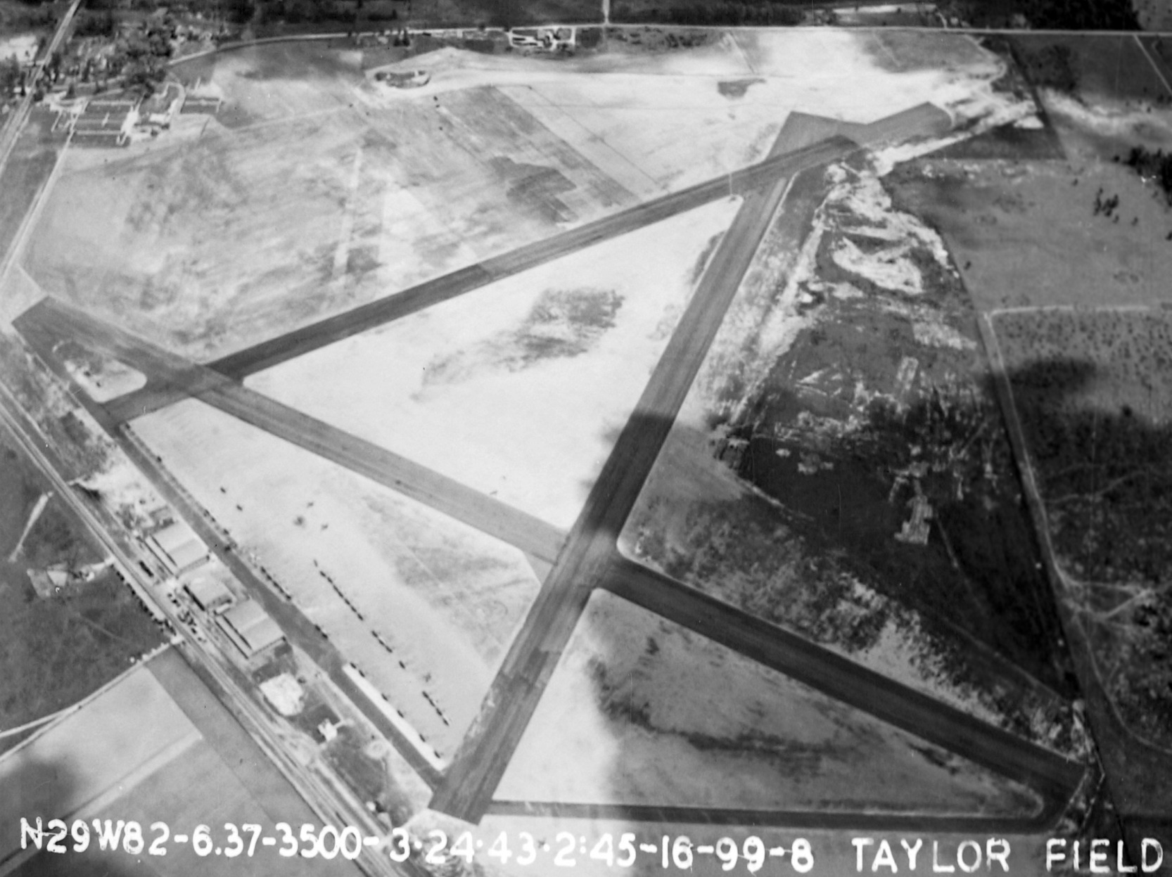
A 3/24/43 aerial view looking east at Taylor Field (courtesy of the Air Force Historical Research Agency, via Brian Rehwinkel),
showing a large number of aircraft parked on the north side near the hangars.
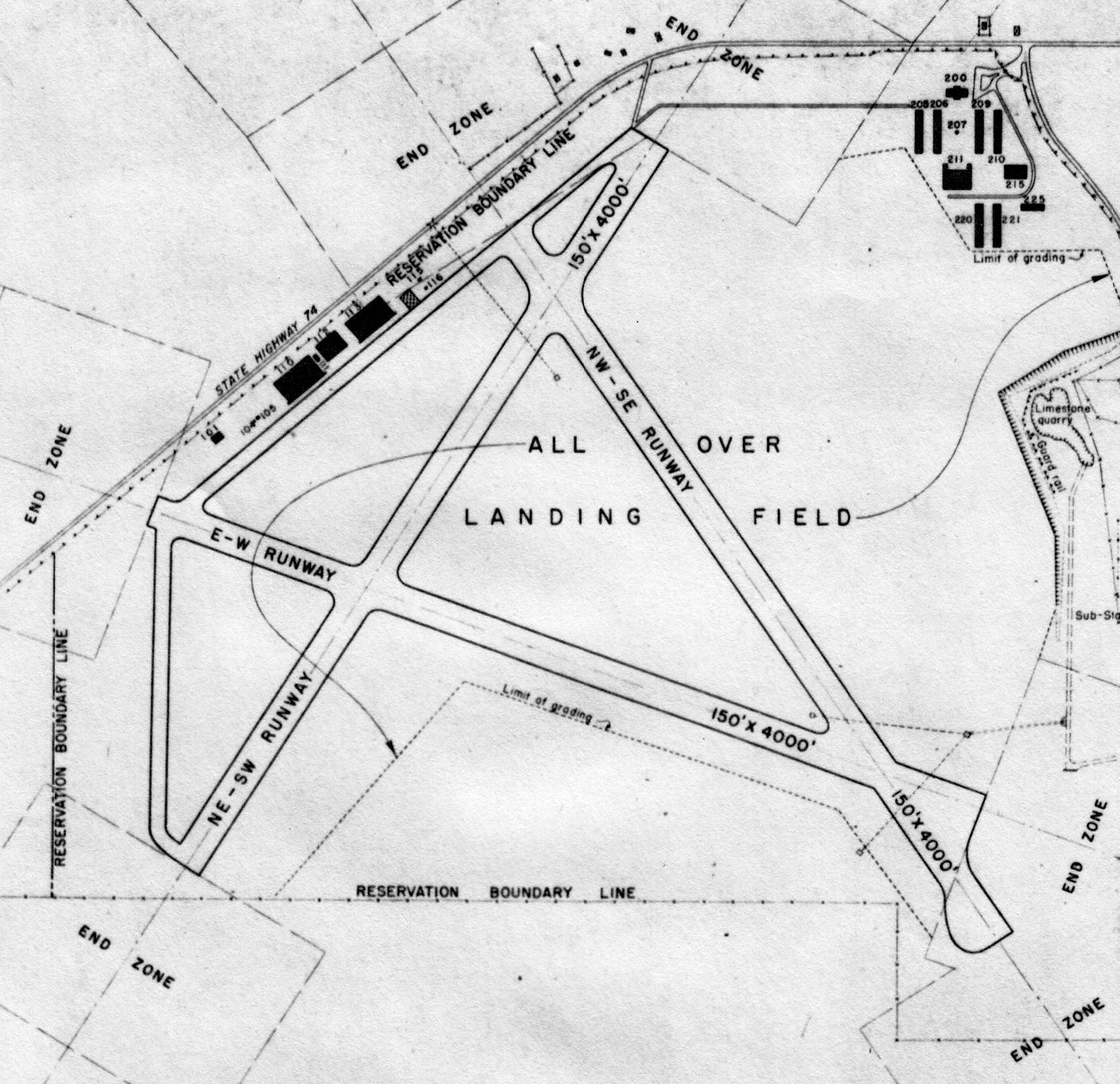
A May 1943 Army Corps of Engineers Layout Plan of “Ocala Airport” (courtesy of the Air Force Historical Research Agency, via Brian Rehwinkel),
showing three 4,000' runways, taxiways, and hangars.
The 1944 US Army/Navy Directory of Airfields (courtesy of Ken Mercer) described "Taylor, Army" as having a 4,000' hard-surface runway.
It was described as a Civilian Pilot Training field, with "extensive training 15 mile radius."
The Greenville Aviation School at Taylor Field closed in September 1944.
Taylor Field continued to operate as a civilian airport after WW2.
Taylor Field was depicted as a commercial/municipal airport on the August 1946 Orlando Sectional Chart (courtesy of Ron Plante).
A 3/9/49 USDA aerial photo of Taylor Field (from the Digital Library Center / University of FL Smathers Libraries, courtesy of Brian Rehwinkel).
At some point between 1940-49 a 3rd paved runway had been added, and the number of hangars along the northwest side of the field had increased to three.
The airfield did not seem to be very active, as not a single plane was visible anywhere on the field.
A group of dorms/classrooms previously used by the Greenville Aviation School were still standing on the northeast corner of the field.
As depicted on a 1956 FL Department of Transportation street map (courtesy of Brian Rehwinkel) Taylor Field had 3 runways.
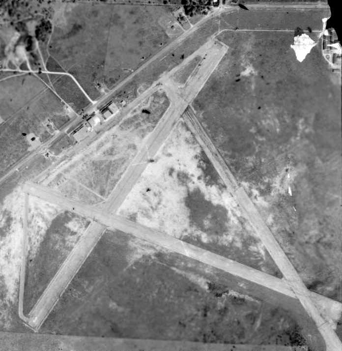
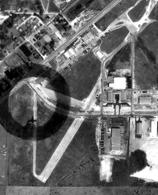
The last photo which has been located showing Taylor Field while it was still open was a 2/2/57 aerial view (from the U of FL Digital Collections).
The airfield configuration was basically the same as seen in 1949. Only 2 light aircraft were visible on the field.
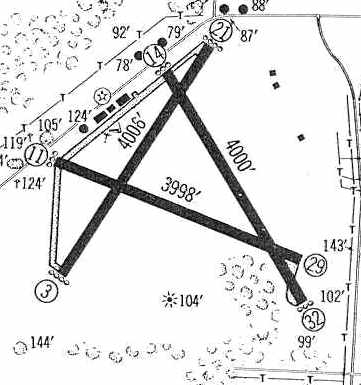
The 1960 Jeppesen Airway Manual (courtesy of Chris Kennedy)
depicted Taylor Field was having 3 paved runways, with the longest being the 4,006' Runway 3/21.
A series of hangars was located along a taxiway on the northwest side of the field.
The last aeronautical chart depiction which has been located of Taylor Field was on the February 1961 Orlando Sectional Chart.
It depicted Taylor as having 3 paved runways, with the longest being 4,000'.
Taylor Field was described by the 1962 AOPA Airport Directory as having a single 5,000' asphalt Runway 18/36, with airline service provided by Eastern Airlines.
Taylor Field was closed in 1962, when it was replaced by a new & larger airport west of the town.
The Taylor Field property was eventually reused as an industrial park.
A 1964 aerial view (from the U of FL Digital Collections) showed Taylor Field to remain completely intact, with 3 paved runways & 4 hangars, but no aircraft were visible on the field.
The April 1965 Orlando Sectional Chart depicted Taylor Field as an abandoned airfield.
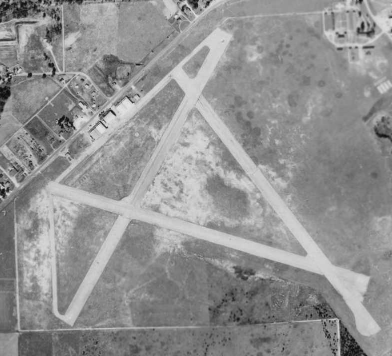
The last photo which has been located of Taylor Field was a 3/6/72 aerial view (from the U of FL Digital Collections).
It showed that industrial buildings had covered the eastern end of the runways, but the former hangars remained standing on the northwest side.
A 1999 USGS aerial photo showed that the former Taylor Field hangars had been removed at some point between 1972-99.
Brian Rehwinkel reported in 2003, "I visited the site about 2 weeks ago & there is very little evidence of the former airfield.
It has been completely transformed into an industrial park. I did photograph a small portion of the remains of one of the former runways."
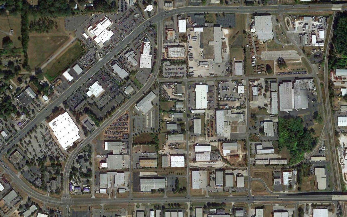
A 2016 aerial photo showed the site of Taylor Field is unrecognizable as a former airfield.
The site of Taylor Field is located south of the intersection of State Road 200 & Martin Luther King Avenue.
____________________________________________________
Flying Seminole Ranch Airport, Chuluotta, FL
28.65, -81.15 (Northeast of Orlando, FL)
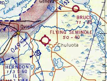
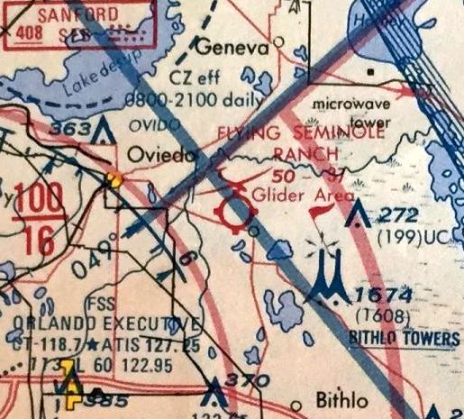
Flying Seminole Airfield, as depicted on the April 1966 Orlando Sectional Chart (courtesy of Chris Kennedy).
This general aviation airport was apparently built at some point between 1964-66,
as it was not yet depicted on a 1957 aerial photo, nor on the April 1964 Orlando Sectional Chart (according to Chris Kennedy).
The earliest depiction which has been located of Flying Seminole Ranch Airfield
was on the April 1966 Orlando Sectional Chart (courtesy of Chris Kennedy).
The Aerodromes table in the chart described "Flying Seminole Ranch Space University" as having a single 4,050' turf runway.
Clark True recalled that "I used to fly there often in 1966-67.
At that time it was a 4,000' turf runway & had a small building for the FBO
and a restaurant that put out a great breakfast for about $3, thus the reason for visiting often.
Usually about 5 plane loads from Cocoa & Rockledge would descend upon them
for breakfast on Sunday mornings before air touring the state for the rest of the day."
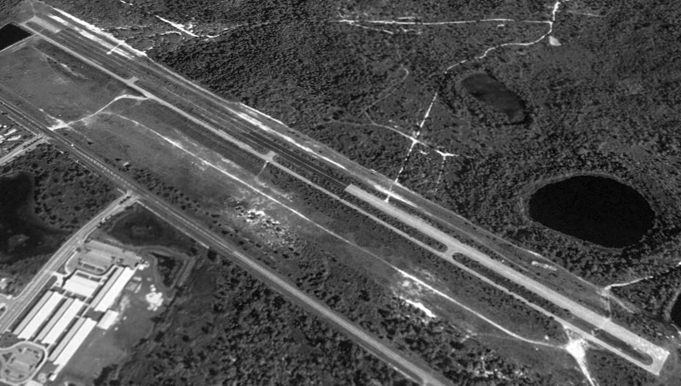
The earliest photo which has been located of Flying Seminole Ranch was a 1972 aerial view (from the U of FL Digital Collections).
It depicted the field as consisting of a single northwest/southeast grass runway.
A 1980 aerial photo showed the field to consist of a grass southeast/northwest runway.
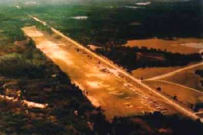
An undated aerial view looking southeast along the Flying Seminole runway (courtesy of Jonathan Taylor).
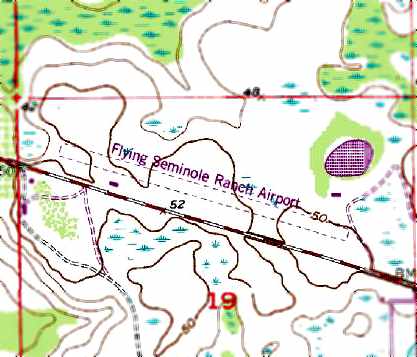
The 1980 USGS topo map depicted the “Flying Seminole Ranch Airport” as having a single unpaved southeast/northwest runway,
with a single building (a hangar?) on the southwest side of the field.
Flying Seminole Ranch Airport was listed in the 1982 AOPA Airport Directory (courtesy of Ed Drury),
which described the field as having a single 4,000' turf Runway 11/29, and listed the operator as Flying Seminole.
The 1985 FL Aeronautical Chart (courtesy of Alex Hauzer) depicted Flying Seminole Ranch Airfield as a 3,700' unpaved runway which conducted glider operations.
Jim Ash reported, "I have log book entries up to 1987 from when I flew gliders there.
They were towing a SGS2-33A, a SGS1-26E, and a Grob 103 with a Cessna L-19.
There was a small office structure mid-field, on the south side of the runway, right next to the road, but no hangars.
A developer bought it (rumor) and built a paved runway next to the grass runway on the north side (fact),
before finding out the western end of the airport under the normal approach was environmentally sensitive wetlands (fact).
The project was abandoned, but not before the glider operation moved to Clermont, FL.
They operate now as Seminole Lake Gliderport. The couple that own the operation are Knut & Ingrid Kjenslie."
The last aeronautical chart depiction which has been located of Flying Seminole Airfield
was on the March 1994 Jacksonville Sectional Chart (courtesy of Ron Plante).
It depicted Flying Seminole Airfield as having a 5,000' unpaved runway.
Flying Seminole Ranch Airfield was evidently closed at some point between 1994-98, as it was no longer depicted on the 1998 aeronautical charts.
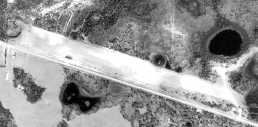
A 1995 USGS aerial view looking northwest showed Flying Seminole Ranch Airfield's original grass runway,
along with its abortive paved runway to the north of the original runway.
A 1999 aerial photo showed the site of Flying Seminole Ranch Airfield to remain unchanged.
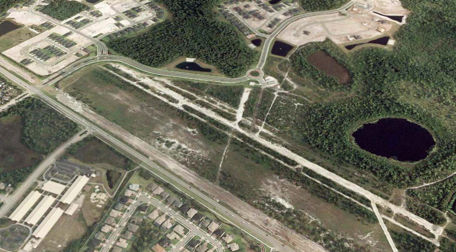
A 2002 aerial view looking northwest showed that the west side of the site of Flying Seminole Ranch Airfield had been covered by construction,
but the majority of the paved & unpaved runways remained intact.
Steve Stern provided an update to the status of the site of the Flying Seminole Ranch in 2004:
"It is now all housing. Urban sprawl from Orlando. The road that runs by there (419) is now 4-laned."
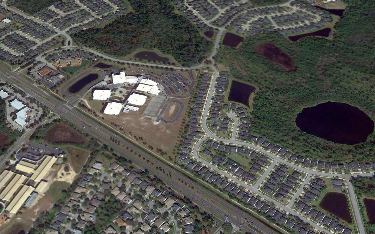
A 2015 aerial view looking northwest showed no trace remaining at the site of Flying Seminole Ranch Airfield,
erasing another vestige of FL aviation history.
The site of the Flying Seminole Ranch Airport is located north of the intersection of Chuluotta Road & Twin Rivers Boulevard.
Thanks to John Foskett for pointing out this airfield.
____________________________________________________
Since this site was first put on the web in 1999, its popularity has grown tremendously.
If the total quantity of material on this site is to continue to grow,
it will require ever-increasing funding to pay its expenses.
Therefore, I request financial contributions from site visitors,
to help defray the increasing costs of the site
and ensure that it continues to be available & to grow.
What would you pay for a good aviation magazine, or a good aviation book?
Please consider a donation of an equivalent amount, at the least.
This site is not supported by commercial advertising –
it is purely supported by donations.
If you enjoy the site, and would like to make a financial contribution,
you
may use a credit card via
![]() :
:
Please consider checking the box to make a monthly donatation.
For a mailing address to send a check, please contact me at: paulandterryfreeman@gmail.com
If you enjoy this web site, please support it with a financial contribution.
please contact me at: paulandterryfreeman@gmail.com
If you enjoy this web site, please support it with a financial contribution.
____________________________________________________
This site covers airfields in all 50 states.