Abandoned & Little-Known Airfields:
Southern Delaware
© 2003, © 2023 by Paul Freeman. Revised 8/7/23.
This site covers airfields in all 50 states: Click here for the site's main menu.
____________________________________________________
Please consider a financial contribution to support the continued growth & operation of this site.
Bethany Beach Airport (revised 3/3/23) - Joseph's Airport (revised 3/3/23)
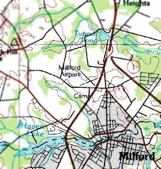
Milford Airpark (revised 2/11/22) - Rehoboth Airport / Aircrafters Airport (revised 8/7/23) - Seaford Du Pont Airport (revised 2/10/20)
____________________________________________________
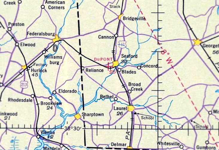
Seaford Du Pont Airport, Seaford, DE
38.63, -75.63 (Southwest of Dover, DE)
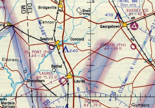
The Du Pont Seaford Airport, as depicted on the November 1941 Washington Sectional Chart.
This private airfield was adjacent to a Du Pont factory, and was evidently built for the use of the Du Pont Company.
The Seaford Du Pont Airport evidently did not predate the Du Pont factory at this location,
as only farmland was depicted at the site on a 1937 aerial photo.
In 1939, with nylon nearing full-scale production, DuPont sought a location for a new plant.
The company chose a 609-acre site near Seaford because of its proximity to raw material supplies & major markets.
The initial project was finished in a mere 7 months, but even before completion the company began work on a second facility,
doubling the site's capacity to 8 million pounds of nylon yarn a year.
Seaford went into production on 12/12/39.
The 6-story plant ran 24 hours a day, producing in its first year of operation enough yarn for 64 million pairs of nylon stockings.
During WW2 the Seaford plant maintained essential national defense production of nylon for parachutes & B-29 bomber tires.
Seaford Du Pont Airport was not yet depicted on the September 1940 Washington Sectional Chart.
The earliest depiction that has been located of the Seaford Du Pont Airport was on the November 1941 Washington Sectional Chart.
It depicted Du Pont as an auxiliary airfield.
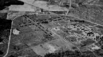
The earliest photo that has been located of the Seaford Du Pont Airport
was a 10/20/43 aerial view looking north from the 1945 AAF Airfield Directory (courtesy of Scott Murdock).
It depicted the field as having 2 grass runways.
The 1945 AAF Airfield Directory (courtesy of Scott Murdock) described Du Pont Seaford Airport
as an 80 acre irregularly-shaped property within which were two 2,100' sod runways, oriented northeast/southwest & northwest/southeast.
The field was said to have a single 50' x 28' metal hangar, and to be privately owned & operated.
After WW2, Seaford remained central to the company's textile fibers production program.
In 1948 DuPont chemical engineers converted one of Seaford's production units
into a pilot plant for "Fiber V," later to be known as Dacron.
A 10/28/54 USGS aerial view showed the Seaford Du Pont Airport to have 2 grass runways on the west side of the factory.
There was no sign of any hangars or other airfield buildings.
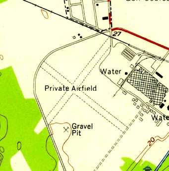
The 1955 USGS topo map depicted the Seaford Du Pont Airport as consisting of 2 perpendicular unpaved runways, labeled “Private Airfield”.
The 2 runways of the Du Pont Airport were still unchanged in a 1961 aerial photo.
The 1964 Washington Sectional Chart depicted Du Pont as a private airfield having a 2,500' unpaved runway.
The last aeronautical chart depiction which has been located of the Seaford Du Pont Airport was on the October 1965 Washington Sectional Chart (courtesy of Ron Kunse).
It depicted Du Pont as a private airfield having a 2,600' unpaved runway.
The 2 runways of the Du Pont Airport were still fairly distinct in a 1968 aerial photo,
but 3 baseball fields had been constructed over the northwest portion.
The Seaford Du Pont Airport was evidently closed at some point between 1965-71,
as it was no longer depicted on the 1971 Washington Sectional Chart.
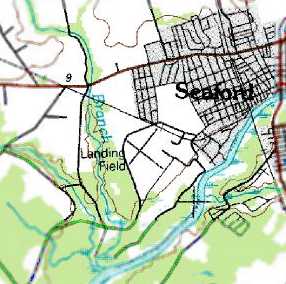
The last map depiction which has been located of the Seaford Du Pont Airport was on the 1992 USGS topo map.
It depicted the 2 runways, labeled simply as “Landing Field”.
Showing that the USGS topo maps can't always be trusted,
a 1992 aerial photo from the same year showed that the runways were no longer recognizable,
with grass having grown over.
A 1997 aerial photo showed that a golf course had been constructed, erasing any trace of the former airfield.
According to Erik Davis, in 2004 Du Pont sold its Seaford facility to Invista.
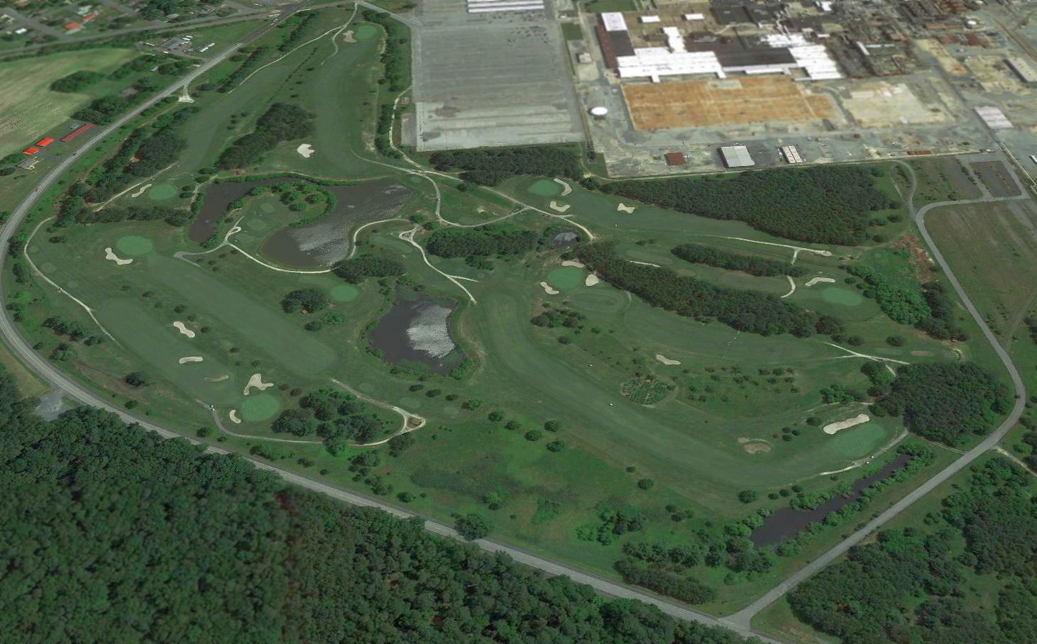
A 2018 aerial view looking northeast showed no trace of the Seaford Du Pont Airport, with the site converted into yet another golf course.
The site of Seaford Du Pont Airport is located southwest of the intersection of Woodland Road & Du Pont Road, appropriately enough.
Thanks to Erik Davis for pointing out this airfield.
____________________________________________________
38.93, -75.44 (Southeast of Dover, DE)
Milford Airpark, as depicted on the October 1948 Washington Sectional Chart (courtesy of Chris Kennedy).
This general aviation airport was evidently constructed at some point between 1947-48,
as only farmland was depicted at the site on a 1937 aerial photo,
and the airport was not yet depicted at all on the April 1947 Washington Sectional Chart (according to Chris Kennedy).
The earliest depiction of Milford Airpark which has been located
was on the October 1948 Washington Sectional Chart (courtesy of Chris Kennedy).
It depicted Milford as having a 2,400' unpaved runway.
Jonathan Carruthers recalled, “I spent many days as a child at the Airpark,
which belonged to my Dad's uncle, Willard Jackson.
Willard was a self-made man, and an aviation pioneer in his own league.
He served in Europe during the latter part of WWII,
and built the Airpark after the war from a single military surplus J-3 Piper Cub he acquired before he left Germany.
He & my father built Hangar #1 from the shipping crate the airplane came in.
I think he got the Cub for the less than $100, the amount the military charged to bring the airplane back on a ship.
Many years later it sold for a lot more then that!”
Jonathan continued, “Willard ran a fairly successful FBO & maintenance shop for many years.
He flew an air taxi service, the workhorse of his aircraft being a pristine Cessna 180 Skywagon.
He owned many other aircraft over the years, but I remember best his beautiful PA-18 Super Cub.
He also offered various agricultural services like crop spraying & dusting, and operated a flight school.
I believe his youngest daughter, Barbara, was one of the youngest females in America to obtain a private pilot's license.
He built an odd-shaped, circular diner at the end of Runway 26
where I used to buy hotdogs & French fries with the money he paid me for mowing the grass around the tie-downs.
It was later converted to a Tastee Freeze. It's been gone for a long time.”
Jonathan continued, “A mosquito spraying operation was hangared at another building off Runway 8,
and I think the aircraft they flew was a surplus B-25 converted for spraying.
The area between the runways was used to grow crops, soy beans I believe.
I learned to drive on a huge Farmall tractor that Willard let me race up & down the runways.”
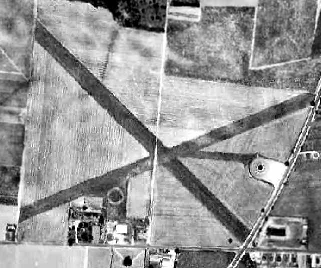
The earliest photo that has been located of the Milford Airpark was a 1954 aerial photo.
The field consisted of 2 grass runways, with a circular airport marking southwest of the runway intersection.
Note the circular diner built by the airport owner, east of the runway intersection,
complete with a taxiway leading from the runways to the diner.
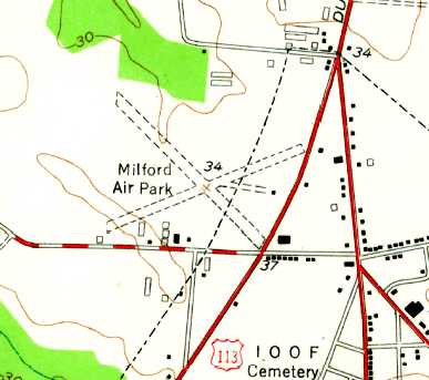
The 1954 USGS topo map depicted “Milford Air Park” as having 2 unpaved runways, and several small buildings to the south & east.
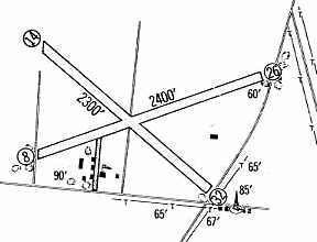
The 1960 Jeppesen Airway Manual (courtesy of Chris Kennedy)
depicted Milford Airpark as having 2 unpaved runways: 2,400' Runway 8/26 & 2,300' Runway 14/32.
A cluster of small buildings was depicted to the southwest of the runway intersection.
A 1961 aerial photo of Milford Airpark
depicted the field as mostly unchanged as compared to the 1954 photo,
but several new buildings had been added along the southwest corner of the property.
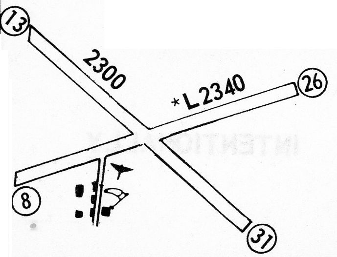
The 1968 Flight Guide (courtesy of Robert Levittan) depicted Milford Airpark as having 2 unpaved runways: 2,340' Runway 8/26 & 2,300' Runway 13/31.
A cluster of small buildings was depicted to the southwest of the runway intersection.
A 1968 aerial photo of Milford Airpark showed that the taxiway leading to the diner on the east side of the field had been removed.
The March 1977 Washington Sectional Chart (courtesy of Chris Kennedy) depicted Milford as a public-use airport having a 2,300' unpaved runway.
The last aeronautical chart depiction which has been located of the Milford Airpark
was on the March 1981 Washington Sectional Chart (courtesy of Ron Plante).
It depicted Milford as a public-use airport having a 2,200' unpaved runway.
The last map depiction which has been located of the Milford Airpark was on the 1984 USGS topo map.
It depicted Milford as having 2 runways.
The last directory listing which has been located of the Milford Airpark was in the 1986 Flight Guide (according to Chris Kennedy).
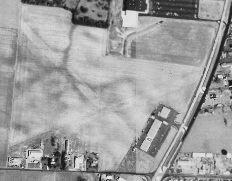
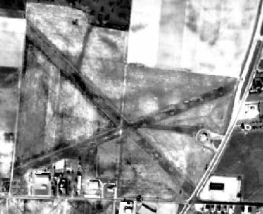
The Milford Airpark was evidently closed (for reasons unknown) at some point between 1986-92,
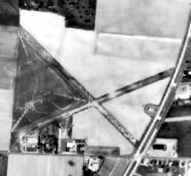
as the 1992 USGS aerial photo depicted a commercial building having been built over the threshold of the former Runway 32.
The majority of the length of the 2 former runways were still recognizable, though,
and the airfield buildings were still intact on the southwest corner of the property.
Jonathan Carruthers observed, “The photo shows the house Willard built on the property just left of the bottom center of the picture,
the main enclosed hangar/machine shop/flight ops office is to the left of the house
(the white inverted L building - the white dots to the north of that building, 12 of them or so, are tie-down stanchions),
and then the row hangars (#1 is closest to Airport Road),
which all had corrugated metal roofs and doors fabricated by Willard & my Dad.
There were 10 or so tenant aircraft housed in those structures, another 5 or 6 in the main hangar.
There were always 3 or 4 aircraft on tie-down.”
According to Jonathan Carruthers, “The Airpark's demise came about when Willard died.
I think his wife, Helga, tried to run the Airpark for a while, as there were several tenant aircraft hangared there,
but she finally sold off most of the land & the hangars were torn down to make way for what is on the site today.”
The Milford Airpark was no longer depicted at all on the 1993 USGS topo map
or the March 1993 Washington Sectional Chart (courtesy of Carl Taylor).
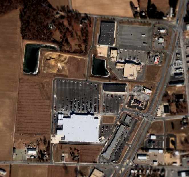
A 2005 aerial photo showed that the Milford Airpark site
had become yet another former airport property to be covered up by a new Wal-Mart.
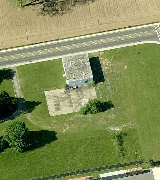
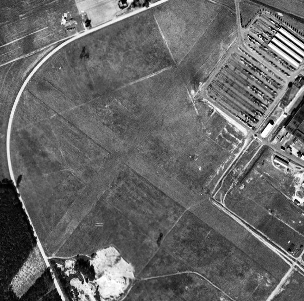
A circa 2008 aerial view looking south at the last visible remnant of the Milford Airpark:
the former hangar/machine shop/flight ops office at the southwest corner of the airfield site.
Brian Foser reported in June 2011, “The hangar/machine shop/flight ops office has been torn down in the Spring of 2011.
The grass didn't take long to grow over the demolition site, and now you can hardly tell anything was ever there.”
The site of Milford Airpark is located northwest of the intersection of Route 1 & Airport Road, appropriately enough.
____________________________________________________
Joseph's Airport (DE49), Georgetown, DE
38.64, -75.36 (Southeast of Dover, DE)
Joseph's Airport, as depicted on the October 1965 Washington Sectional Chart (courtesy of Ron Kunse).
This private airfield was evidently constructed at some point between 1961-65,
as it was not yet depicted at all on a 1961 aerial photo
or on the April 1965 Washington Sectional Chart (according to Chris Kennedy).
The earliest depiction of Joseph's Airport which has been located
was on the October 1965 Washington Sectional Chart (courtesy of Ron Kunse).
It depicted Joseph's as a private airfield having a 3,400' unpaved runway.
The 1967 AOPA Airport Directory (according to Chris Kennedy)
described the “M. L. Joseph Company” airfield as having a single 3,400' turf Runway 15/33.
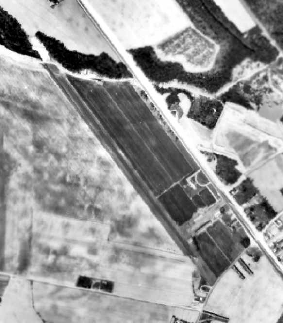
A 1968 aerial photo of Josephs Airfield depicted the field as having a single northwest/southeast runway.
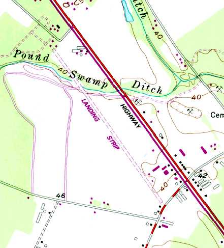
The 1985 USGS topo map depicted Josephs Airfield as a single paved runway, labeled “Landing Strip”,
which had been lengthened somewhat to the northwest at some point between 1968-85.
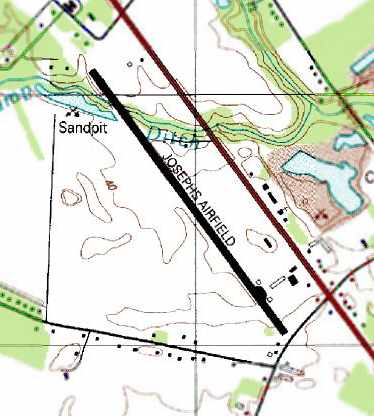
The 1992 USGS topo map depicted “Josephs Airfield” as having a single paved runway with several buildings on the southeast side.
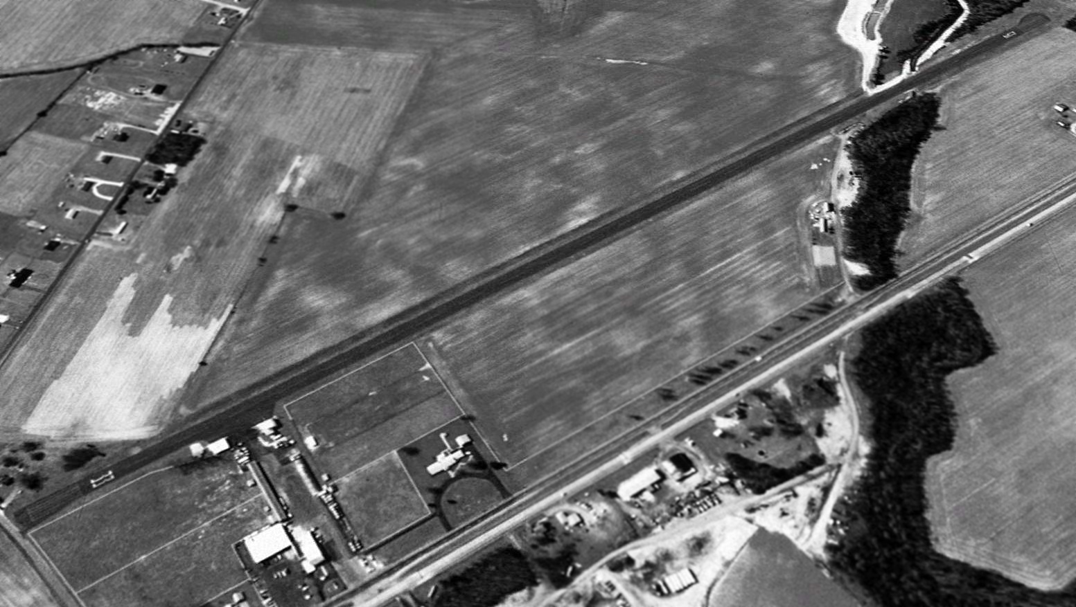
A 1992 USGS aerial view looking west depicted Joseph's Airport as having a single paved runway
with a hangar & several other buildings at the southeast end of the field.
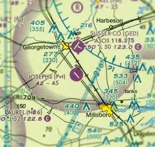
The 2006 Washington Sectional Chart depicted Josephs as a private field with a single 4,500' paved runway.
Note the proximity of the Sussex County Airport, less than 2 miles to the north.
Alex McMahon observed in 2006 of Joseph's Airport: “A great little airport with horrible luck.
The original owner lived on the field & owned a variety of bizjets over the past 40 years until his recent death [7/26/05].
Soon after that, while the airport was on the brink of closing,
an Archer on short final to Runway 33 clipped a car, killing the vehicle's 2 occupants.
The airport was then closed for good.”
In 2006, the FAA Airport Facility Directory data described Joseph's Airport as having a single 4,564' asphalt Runway 15/33.
The field was said to be owned by the Melvin Joseph Construction Company,
with the manager being Richard Swain.
Two aircraft were said to be based on the field: 1 jet & 1 single-engine aircraft.

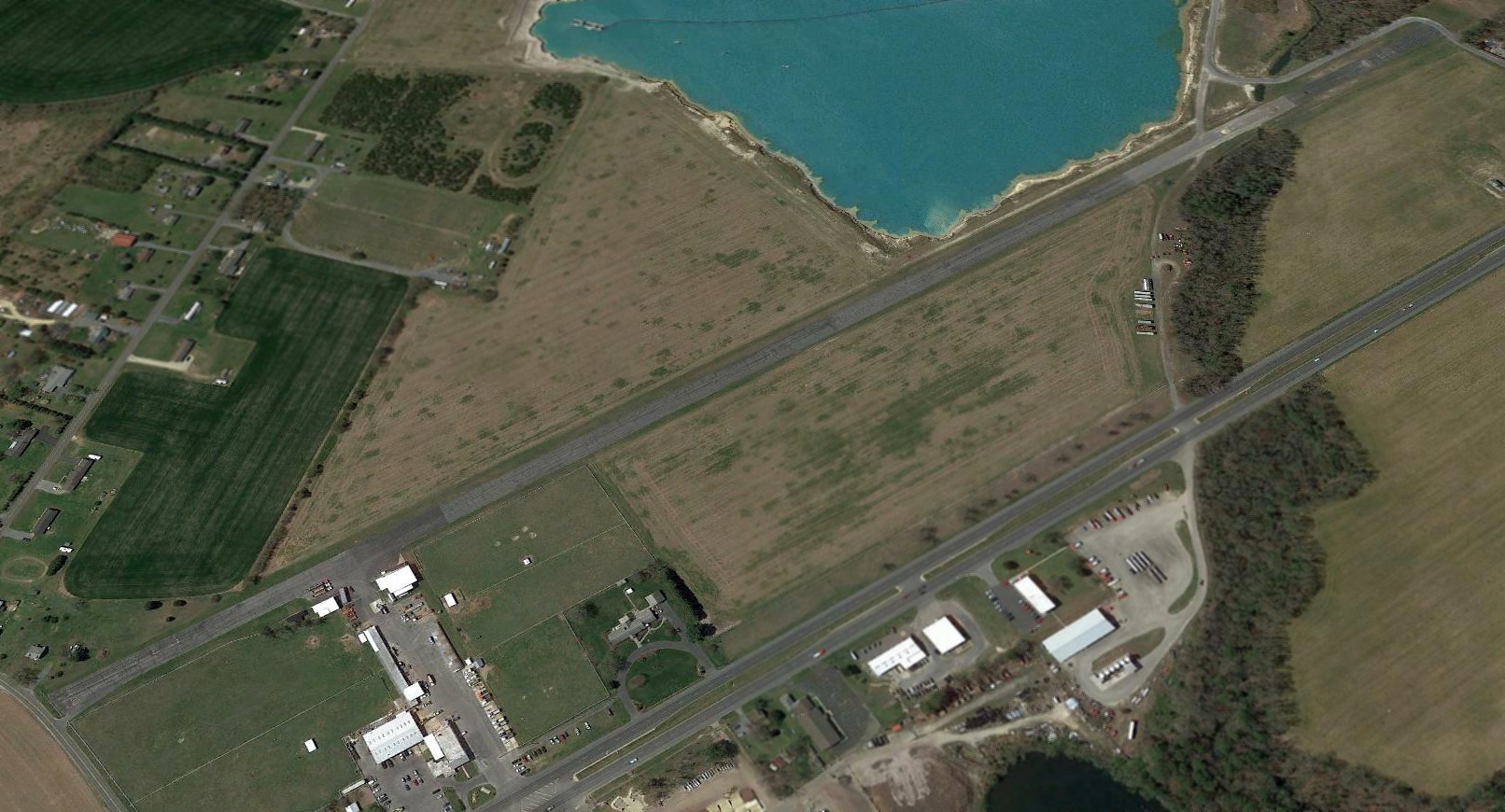
A May 2006 aerial view by Alex McMahon, looking northwest along the former Runway 33.
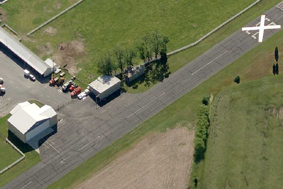
A circa 2007 aerial view looking east at the 2 hangars & closed runway at Joseph's.
A 2017 aerial view looking west depicted Joseph's Airport as remaining completely intact.
What a shame to see this fine piece of aviation infrastructure going to waste.
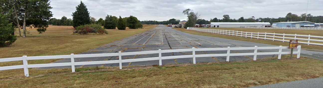
An October 2019 photo looking northwest showed the Joseph's Airport paved runway remaining completely intact.
Joseph's Airport is located west of the intersection of Dupont Boulevard & Governor Stockey Road.
____________________________________________________
Bethany Beach Airport, Bethany Beach, DE
38.55, -75.06 (Southeast of Dover, DE)
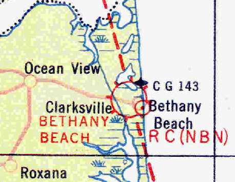
"Bethany Beach" Airport, as depicted on the May 1932 Washington Airway Chart (courtesy of Chris Kennedy).
This small former military airfield was located on the grounds of a small Delaware Army National Guard facility,
less than a quarter-mile from the Atlantic Ocean.
The Bethany Beach Airfield was apparently built at some point between 1929-32,
as it was not yet depicted on the 1929 Rand-McNally Air Trails map of MD & DE (according to Chris Kennedy).
The earliest depiction of the airfield which has been located was on the May 1932 Washington Airway Chart (courtesy of Chris Kennedy).
It depicted "Bethany Beach" as a civilian airport, with a radio beacon very close by to the southeast.
The Airport Directory Company's 1933 Airport Directory (courtesy of Chris Kennedy)
described "Bethany Beach" as an Army airfield.
It was described as having 2 sod runways in a cross shape, 1,500' north/south & east/west.
The field was said to offer "fuel during National Guard encampment."
That comment provides a clue as to this airfield's status as a military or civilian airfield
(of which it was seemingly randomly depicted on subsequent aeronautical charts).
Perhaps the Bethany Beach Airfield was available for civilian use
at times other than when the National Guard was conducting an encampment at the site?
It was described in the same manner in The Airport Directory Company's 1937 Airport Directory (courtesy of Bob Rambo).
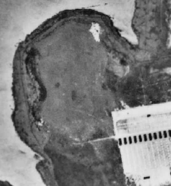
A 1937 aerial photo of Bethany Beach Airport
showed the field to be simply an open grass area, with the National Guard encampment to the southeast.
The August 1939 Washington Sectional Chart (courtesy of Chris Kennedy) depicted "Bethany Beach" as a military airfield.
The Airport Directory Company's 1941 Airport Directory (courtesy of Chris Kennedy) described "Bethany Beach" as an Army airfield.
It was described as having 2 sod runways in a cross shape, 1,500' north/south & east/west.
The field was said to offer "fuel during National Guard encampment."
"Bethany Beach" was also depicted as a military airfield on the December 1942 Washington Sectional Chart (courtesy of Chris Kennedy).
"Bethany Beach" was depicted as a commercial or municipal airport on the May 1943 Washington Sectional Chart (courtesy of Chris Kennedy).
The 1943 USGS topo map did not depict any airfield on the site, but labeled the property as “U.S. Military Reservation (Fort Miles)”.
The Bethany Beach Airport was evidently closed (for reasons unknown) at some point between 1943-44,
as it was no longer depicted at all on the May 1944 Washington Sectional Chart (according to Chris Kennedy),
nor listed among active airfields in the 1945 AAF Airfield Directory (courtesy of Scott Murdock).
A 12/8/53 USGS aerial photo showed the site of Bethany Beach Airport to be simply an open grass area, with the National Guard encampment to the southeast.
The 1954 USGS topo map did not depict any airfield on the site, but labeled the property as “U.S. Army Camp”.
But the Bethany Beach Airport evidently reopened at some point after WW2,
as Tom O'Connell recalled, “Bethany was a wonderful airport.
In the fall on a Sunday afternoon, they would hawk passenger rides at a stand beside the road between Naugatuck & New Haven,
and have music on a loud speaker, and a UPF7 WACO, would do rides,and PA12s with 150 hp engines would tow banners.
They had a club (Sundowners Club) for partying after sundown. It was a lively place. It closed in 1962 or 1963.
I remember Bethany as a wonderful place for a young man aspiring for a career in aviation. It is truly a fond memory.”
A 1963 aerial photo depicted a single north/south grass runway.
Charlie Smith recalled, “In 1967 I was an Officer Candidate in Delaware Officer Candidate School Class 12,
and we had orientation flights in a DeHavilland Canada U-6A Beaver
which flew into & out of the grass strip at the Bethany Beach Training Site.
The pattern typically flown was landing from the South & takeoffs toward the north over the Salt Pond.
As Army aviation evolved, the airfield was used by rotary-wing aircraft, including the Bell UH-1 Iroquois (Huey).”
A 1968 aerial photo of Bethany Beach Airport showed the field to consist of a single north/south grass runway.
The 1972 USGS topo map did not depict any airfield on the site.
The 1981 USGS topo map did not depict any airfield on the site, but labeled the property as “Delaware National Guard”.
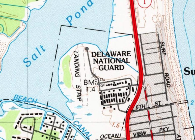
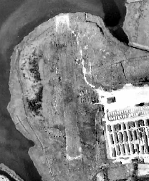
The 1984 USGS topo map still depicted a single north/south unpaved runway, labeled simply as "Landing Strip".
The surrounding property was still labeled as "Delaware National Guard".

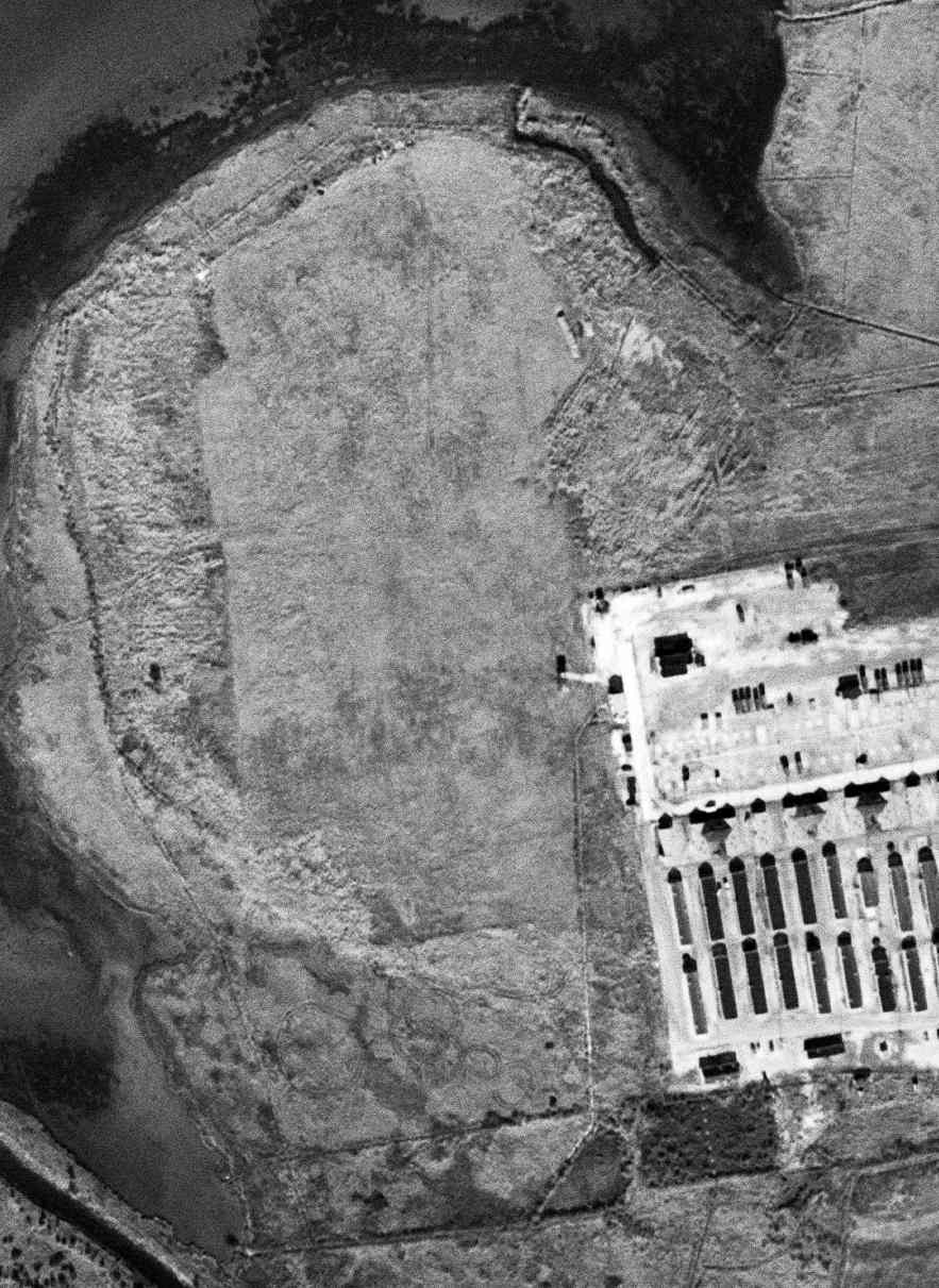
A 1999 USGS aerial view looking northeast showed the former Bethany Beach Airport north/south grass runway remained quite recognizable,
although there was no indication of any recent aviation use.
As of 2004, the "Bethany Beach Training Site" was still in use by the DE National Guard's 193rd Regiment Regional Training Institute,
the home of the Delaware Officer Candidate School.
The Officer Candidate School had been conducted by the RTI (former State Academy) since Class #1 in 1957.
A 2005 aerial view showed an asphalt oval running track had been built over the former grass runway at some point between 1999-2005.
Charlie Smith reported in 2005 that the Bethany Beach airfield is still used for military helicopter operations,
and “also serves as a parade field for military reviews.
A half-mile oval running track has been built around the airfield area.”
Paul Freeman drove by the perimeter of the Bethany Beach Training Site in 2006,
and found that a Bell UH-1 helicopter was mounted on a pylon along Route 1,
along with several artillery pieces & tracked vehicles on static display.
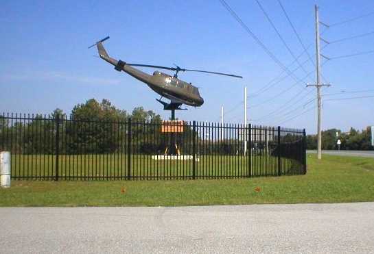
A 2007 photo of a Bell UH-1 mounted on static display at the entrance to the Bethany Beach Training Site.
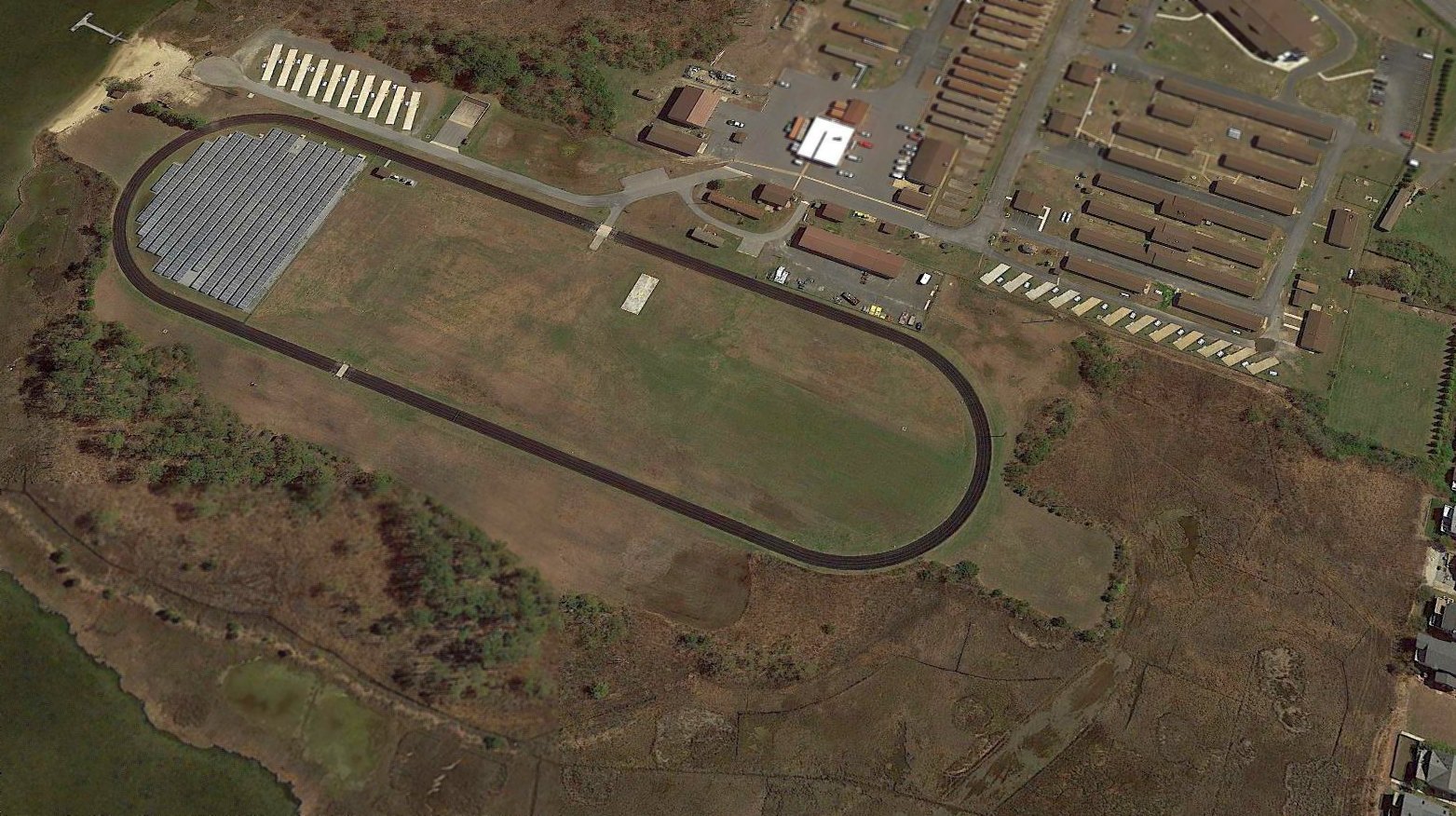
A 2017 aerial view looking northeast showed the oval running track covering the site of Bethany Beach Airport, with solar cells on the northern portion.
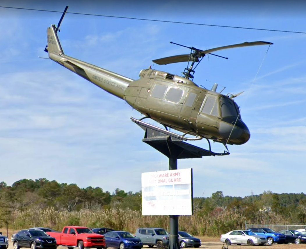
An October 2019 photo looking northwest at a Bell UH-1 mounted on static display at the entrance to the Bethany Beach Training Site.
The site of Bethany Beach Airport is located northwest of the intersection of Route 1 & 5th Street.
____________________________________________________
Rehoboth Airport (REH) / Aircrafters Airport, Rehoboth Beach, DE
38.72, -75.12 (Southeast of Dover, DE)
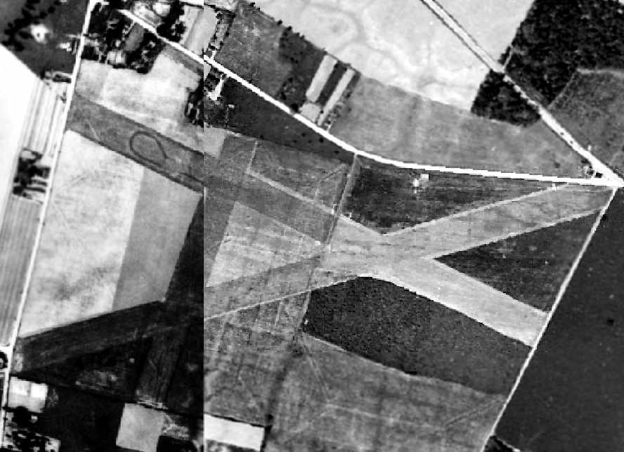
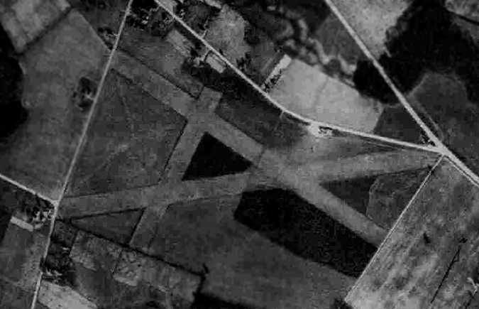
A 1937 aerial photo of Rehoboth Airport
showed the field to have 3 grass runways, with a few small buildings along the north side of the field.
The date of construction of the Rehoboth Airport is unknown.
It was apparently built at some point between 1935-37,
as it was not yet depicted on the 1935 Washington Sectional Chart.
The Airport Directory Company's 1937 Airports Directory (courtesy of Bob Rambo)
listed a Rehoboth Beach Airport adjacent to the southwest side of the town, "Field under construction".
It was described as having 3 landing strips, with the longest being a 1,650' east/west strip, and a single hangar.
A 1937 aerial photo of Rehoboth Airport
showed the field to have 3 grass runways, with a few small buildings along the north side of the field.
Rehoboth Airport was not yet depicted on the September 1938 Washington Sectional Chart.
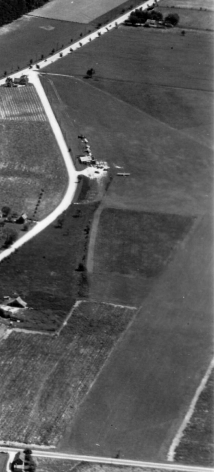
A 1939 aerial view looking east at a portion of Rehoboth Airport -
the hangar with several planes is in the center of the photo,
and the runway starts at the bottom of the photo & runs off the center-right edge.
The picture is from the Dallin Aerial Survey Collection,
courtesy of Barbara Hall of the Hagley Museum & Library, Wilmington, DE.
The earliest aeronautical chart depiction which has been located of Rehoboth Beach Airport was on the January 1940 Washington Sectional Chart.
Note that it depicted the airport's location (directly adjacent to the southwest side of the town) somewhat differently than later depictions.
Was this an error, or was the airport originally located here?
A 8/1/41 aerial view from the 1945 AAF Airfield Directory (courtesy of Scott Murdock)
depicted Rehoboth Airport as having 3 grass runways.
Rehoboth Beach was depicted as a commercial airport
on the 1942 Washington Sectional Chart (courtesy of Mike Keefe).
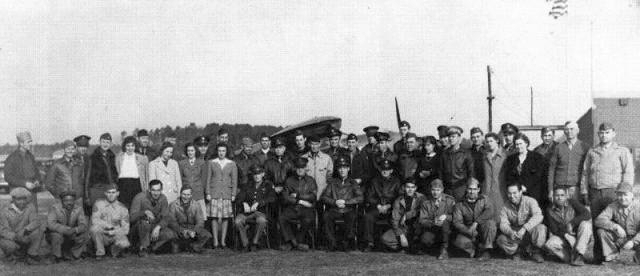
A circa 1942-43 photo of the members of Civil Air Patrol Coastal Patrol Base #2 at Rehoboth Airport.
There were as many as 70 members assigned to Base 2, including women, and wives of flyers.
According to Ron MacArthur's 3/3/17 Cape Gazette article “Air war waged from Rehoboth Beach airport” (courtesy of Tun Ryan),
“During the early days of World War II, the Rehoboth Beach Airport was pivotal to securing the Atlantic Coast from unrelenting attacks on U.S. ships by German submarines.
Coastal Patrol Base 2 in Rehoboth Beach was among the first of 21 bases activated, from Maine to Texas.
Eighteen months of vigilant bombing & surveillance missions eventually paid off, and German submarines scaled back their attacks.
These were civilians, flying retrofitted planes with bombing racks, who conducted routine patrols as far out as 60 miles off the coast.
Flying out of where Airport Road is today, local pilots were in the thick of it, flying missions looking for German U-boats from 2/26/42 – 9/28/43.
Base 2 flew the very first mission, made the first sub sighting & was home to the first two civilians ever awarded the Air Medal, said Everett Bennett.
When the base was deactivated in fall 1943, pilots carried supplies & towed targets for Fort Miles gunnery crews.”
In 1942, Maj. Hugh Sharp & Lt. Eddie Edwards of the Civil Air Patrol took off from Rehoboth
in an amphibian aircraft to rescue the pilot of an aircraft which had ditched 20 miles offshore in the Atlantic.
For their bravery in the ensuing rescue, Sharp & Edwards were awarded the Air Medal by President Roosevelt.
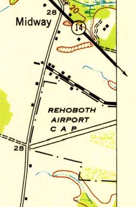
The 1943 USGS topo map depicted the “Rehoboth Airport C A P” as having a single northeast/southwest runway.
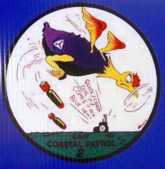
The logo of Rehoboth Airport's Civil Air Patrol Coastal Patrol #2 was a cartoon blue hen chicken dropping bombs on a German U-Boat.
The "Rehoboth, Army" airfield was listed in the 1944 US Army/Navy Directory of Airfields (courtesy of Ken Mercer).
It was described as having a 3,700' runway,
and the remarks said "Civil Air Patrol Coastal Patrol Base #2".
The 1945 AAF Airfield Directory (courtesy of Scott Murdock) described Rehoboth Airport
as an 144 acre rectangular property within which were 3 sod & loam runways, with the longest being the 3,700' northeast/southwest strip.
The field was said to have 3 hangars, with the largest being a 50' x 40' wooden structure.
Rehoboth Airport was described as being privately owned.
Rehoboth was once again depicted as a commercial airport
on the 1946 Washington Sectional Chart (courtesy of Mike Keefe).
The 1949 Washington Sectional Chart (courtesy of Mike Keefe)
described Rehoboth as having a 3,500' unpaved runway.
A 1954 aerial photo of Rehoboth Airport
showed that the field had gained a 4th grass runway at some point between 1937-54,
as well as a larger number of buildings along the north side of the field.
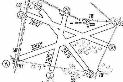
The 1960 Jeppesen Airway Manual (courtesy of Chris Kennedy)
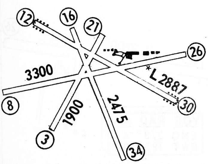
depicted the Rehoboth Aircrafters Airport as having a total of four unpaved runways,
with the longest being the 3,300' Runway 8/26.
A row of buildings was depicted on the north side of the field.
According to Chet Bridgeman, Rehoboth Beach Airport "was mentioned in a book called Zero 3 Bravo by Mariana Gosnell."
Tim Ryan recalled, “I flew out of Rehoboth Aircrafters Airport in 1962 as a student pilot.
The owner-operator of REH at that time was Hal Wallin.
Hal & his wife handled the entire operation of the airport, and Hal was also head flight instructor.
Hal was a soft-spoken gentleman & cool as a cucumber - he never got rattled when I messed up during a training flight.
I took my first solo flight at REH. I had gone for a Saturday morning instruction flight & was working with Hal on my take-offs & landings.
And I wasn't doing so great that morning. At about halfway through my hour, Hal had me taxi back to the terminal.
I thought sure he was going to kick me out of the airplane & tell me not to bother coming back.
Instead, he climbed out of the cockpit & said, 'Watch out for other traffic.'
I didn't think I heard him right, due to the roar of the engine, and I looked at him quizzically.
He repeated the instruction about other traffic, and when I continued to look dumb, he swept his thumb toward the strip & shouted, 'Get out of here.'
I was cleared to solo!”
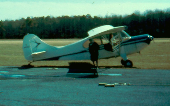
A 3/10/63 photo at Rehoboth Airport, which Tim Ryan recalled was “'of me in Hal's Aeronca Champ, deplaning my mother after a ride of terror.
Mrs. Wallin chewed me out royally for leaving the engine running during deplaning. I deserved it. Never did it again.”
Tim Ryan recalled, “REH was a beautiful airport indeed. Landing there was like landing on a golf course.
Taking off on a summer evening when the air was calm was like sailing on a sea of whipped cream.”
It was still labeled "Rehoboth" on the 1964 Washington Sectional Chart (courtesy of John Voss),
but the Aerodromes table on chart gave the full name as "Rehoboth Aircrafters" Airport.
It was described as having a total of 4 runways, with the longest being a 3,300' turf strip.
Bruce Russell recalled, “I worked summers while in college for a small Part 135 charter outfit named Air Exec, Inc.
We were headquartered at the Ocean City Airport
but also had a ticket office & waiting area at Washington National (DCA) airport adjacent to Page Aviation who was the DCA FBO at that time.
We operated Piper Arrows, Senecas, Navajos and one DHC6-300 Twin Otter.
During the summer, we would fly 4 round-trips daily between Washington National, Rehoboth Beach, Ocean City and back to DCA.
We normally used the Otter since it carried 19 passengers
and was very comfortable operating in & out of Rehoboth’s semi-short grass runway.
The Twotter was in it’s element operating in & out of REH.
Flying that big turboprop was like flying a Cessna 182 on steroids!
I took the Seneca into REH a couple of times & that was a bit more exciting.
I personally never flew the Navajo into REH, but I know it was done… not a smart move in my opinion.
I mostly flew the charter flights for Air Exec & not the regularly scheduled flights between DCA & the Atlantic beaches.”
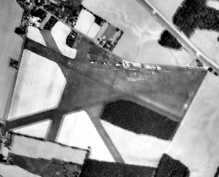
A 1968 aerial photo of Rehoboth Airport depicted the field as having 4 grass runways.
The 1968 Flight Guide (courtesy of Robert Levittan) depicted Rehoboth Beach Aircrafters Airport
as having 4 unpaved runways, with the longest being the 3,300' Runway 8/26.
A row of small buildings was depicted to the northeast of the runway intersection.
Stephen Mahaley recalled, "I remember in the 1970s there was actually commercial service at this airport.
I remember flying from Washington National to Rehoboth & then to Ocean City, MD.
They flew Piper Navajos & Twin Otters on the route.
It's got to be one of the smallest airports in the country to ever have had commercial service.
There were 3 or 4 round trips a day. Summertime only."
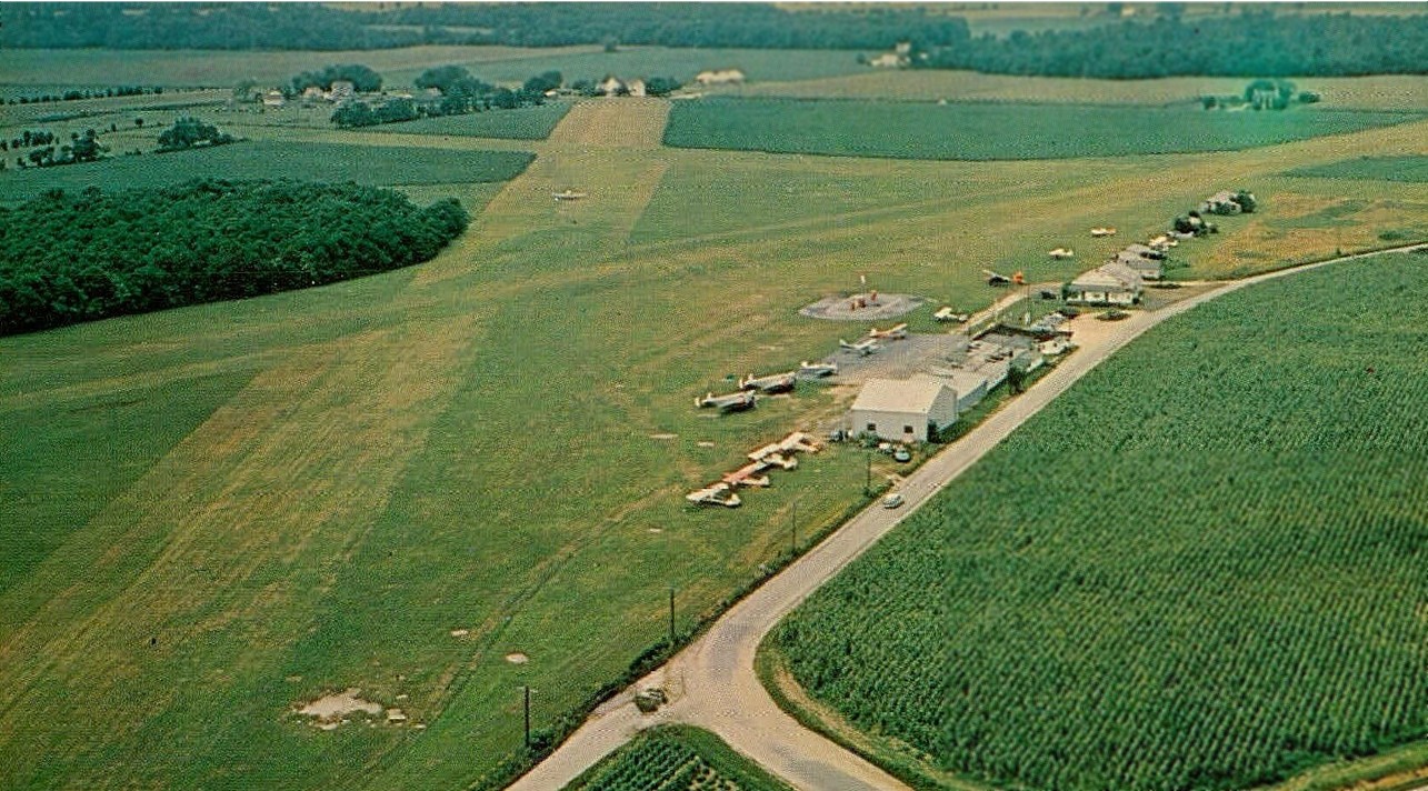
A circa 1970s postcard aerial view looking northeast at Rehoboth Airport (courtesy of Bill Grasha)
depicted 3 grass runways, 14 light planes, several hangars, an office/terminal building with a paved ramp, and a small paved area around the fuel island.
According to Bruce Russell, Rehoboth airline operator Air Exec
“closed operations sometime soon after the 1973 Arab Oil Embargo & the ensuing economic downturn.”
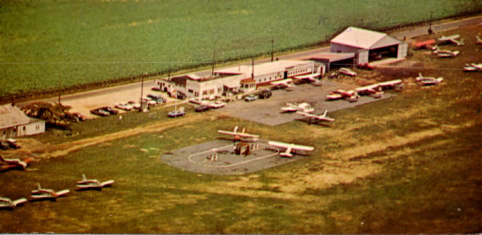
The 1975 aerial view looking northeast at Rehoboth Airport (courtesy of Philip Kineyko) depicted several hangars,
an office/terminal building with a paved ramp, and a small paved area around the fuel island.
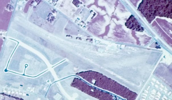
The last photo which has been located of Rehoboth Airport was an 8/4/76 USGS aerial view.
At some point between 1968-76 the field had been reduced to 1 runway, with newly-constructed streets covering the location of the other 3 runways.
Several light planes were visible parked near the hangars on the north side of the field.
The last aeronautical chart depiction which has been located of Rehoboth Airport was on the March 1981 Washington Sectional Chart (courtesy of Ron Plante).
It described Rehoboth Airport as having a 2,800' unpaved runway.
Rehoboth Aircrafters Airport was listed among active airfields in the 1982 AOPA Airport Directory (courtesy of Ed Drury).
It was described as having a single 2,790' turf Runway 12/30, and the operator was listed as Garrison Aviation, Inc.
The 1984 USGS topo map depicted Rehoboth Aircrafters Airport as having 2 runways:
a 2,500' northwest/southeast primary runway,
and a 1,000' northeast/southwest crosswind runway.
According to Jim Fairweather, “The large hangar pictured top right in the 1975 aerial photo
was rented by The Rehoboth Beach Volunteer Fire Company in 1985, for use as a second station.”
Rehoboth Aircrafters Airport was depicted on a 1986 VOR-A Approach Plate (courtesy of John Clifford).
In 1986 it must have been fairly uncommon for a grass-runway airport to have an instrument approach.
John Baker recalled that "My last flight from Rehoboth, Delaware airport (REH) was on 7/7/86.
I would fly there while my family was in Bethany Beach for summer vacations.
It was also my last flight in my Aeronca 7BCM Champ, N82872, that I sold later in the month.”
Rehoboth Aircrafters Airport was still depicted as an active airfield on the 1987 MD Aeronautical Chart, with a 2,700' runway.
According to Jim Fairweather, “In 1987 they [the Rehoboth Beach Volunteer Fire Company]
acquired land at Route 1 & Airport Road, across from the airport property, and relocated the hangar there.”
According to Ron MacArthur's 3/3/17 Cape Gazette article “Air war waged from Rehoboth Beach airport” (courtesy of Tun Ryan),
“The Rehoboth airfield closed in 1987.”
Rehoboth Airport was no longer depicted on the 1989 Washington Sectional Chart.
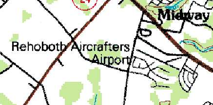
Strangely, the 1991 USGS topo map still labeled the site as "Rehoboth Aircrafters Airport",
even though it no longer depicted the runways at all,
but instead depicted the residential streets which had by that time covered the airport site.
The 1992 USGS aerial photo showed that the Rehoboth Aircrafters Airport site had been covered by a housing development,
with several new streets having been built over the location of the runways.
Jim Fairweather reported in 2006 that the former hangar “is still in use today [by the Volunteer Fire Company],
although extensively renovated.”
According to Ron MacArthur's 3/3/17 Cape Gazette article “Air war waged from Rehoboth Beach airport” (courtesy of Tun Ryan),
“The only reminder of the Rehoboth airfield is a state historical marker placed along Airport Road in 2006; the field is now the Rehoboth Shores Estates community.”

A 2015 aerial view showed the site of Rehoboth Aircrafters Airport had been largely covered by a housing development.
The site of Rehoboth Beach Aircrafters Airport is located south of Martins Road, 2 miles west of Rehoboth Beach.
____________________________________________________
<
Since this site was first put on the web in 1999, its popularity has grown tremendously.
If the total quantity of material on this site is to continue to grow,
it will require ever-increasing funding to pay its expenses.
Therefore, I request financial contributions from site visitors,
to help defray the increasing costs of the site
and ensure that it continues to be available & to grow.
What would you pay for a good aviation magazine, or a good aviation book?
Please consider a donation of an equivalent amount, at the least.
This site is not supported by commercial advertising –
it is purely supported by donations.
If you enjoy the site, and would like to make a financial contribution,
you
may use a credit card via
![]() :
:
Please consider checking the box to make a monthly donatation.
For a mailing address to send a check, please contact me at: paulandterryfreeman@gmail.com
If you enjoy this web site, please support it with a financial contribution.
please contact me at: paulandterryfreeman@gmail.com
If you enjoy this web site, please support it with a financial contribution.
____________________________________________________
This site covers airfields in all 50 states.