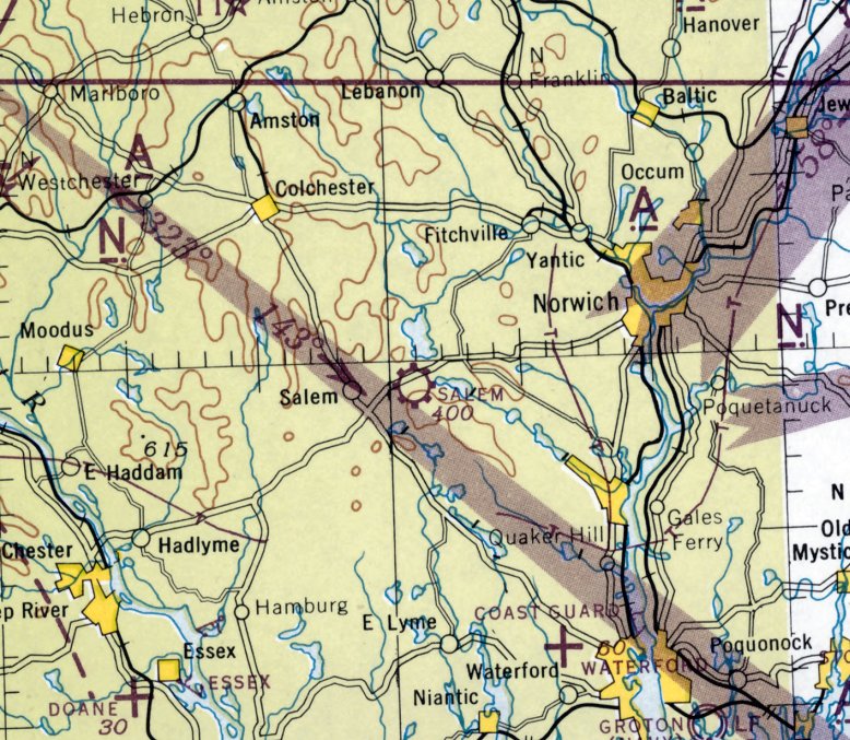
Abandoned & Little-Known Airfields:
Eastern Connecticut
© 2002, © 2024 by Paul Freeman. Revised 7/13/24.
This site covers airfields in all 50 states: Click here for the site's main menu.
____________________________________________________
Please consider a financial contribution to support the continued growth & operation of this site.
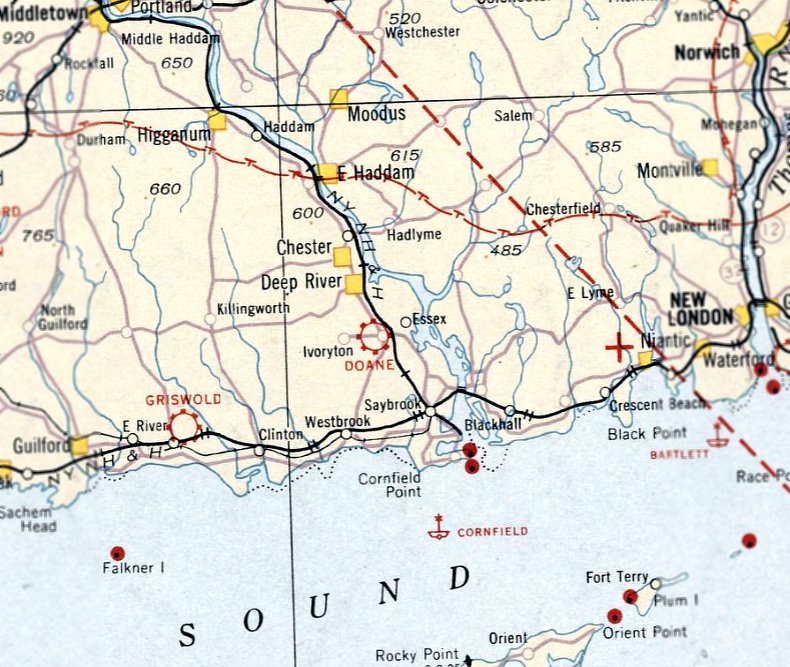
Doane Airport / Essex Airport (revised 7/13/24) - New London Waterford Airport (revised 8/29/23)
Pachaug Airport / Lakeside Airport (revised 8/15/23) - Salem Airport (revised 6/1/16) - Swift Airfield (added 3/1/20)
____________________________________________________
Swift Airfield, Stafford Springs, CT
41.965, -72.337 (Northeast of Hartford, CT)
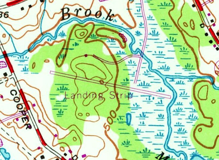
Swift Airfield, as depicted on the 1970 USGS topo map.
This private airfield was evidently established at some point between 1966-70,
as it was not yet depicted on the 1966 USGS topo map.
The earliest depiction which has been located of Swift Airfield was on the 1970 USGS topo map.
It depicted a single paved southeast/northwest runway, generically labeled as “Landing Strip”.
The earliest photo which has been located of Swift Airfield was a 1970 aerial view.
It depicted a single asphalt northwest/southeast runway, which appeared to have just been constructed.
There were no buildings or other improvements visible.
Swift Airfield was not yet depicted on the April 1970 NY Sectional Chart.
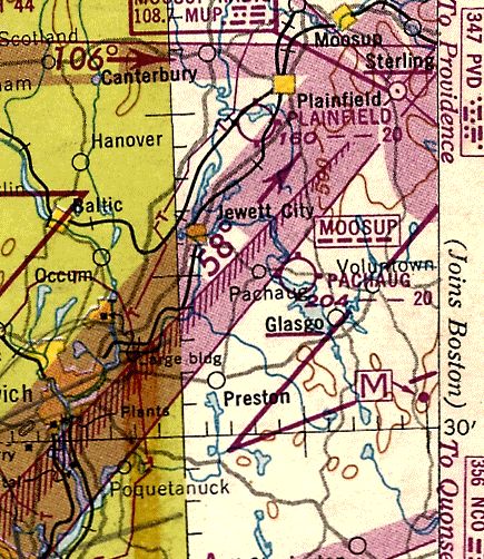
The earliest aeronautical chart depiction which has been located of Swift Airfield was on the January 1973 NY Sectional Chart (courtesy of Ron Plante).
It depicted Swift as a private airfield having a single 2,800' paved northwest/southeast runway.
The earliest photo which has been located of Swift Airfield was a 1991 USGS aerial view looking southwest.
It depicted a single paved southeast/northwest runway, with a few small buildings on the northeast side.
There were no aircraft visible, or any other sign of recent aviation use.
The earliest aeronautical chart depiction which has been located of Swift Airfield was on the May 2001 NY Sectional Chart (courtesy of Ron Plante).
It depicted Swift as a private airfield having a single 2,600' paved northwest/southeast runway.
Swift Airfield was evidently closed (for reasons unknown) at some point between 2001-2016,
as it was no longer depicted on the April 2016 NY Sectional Chart.

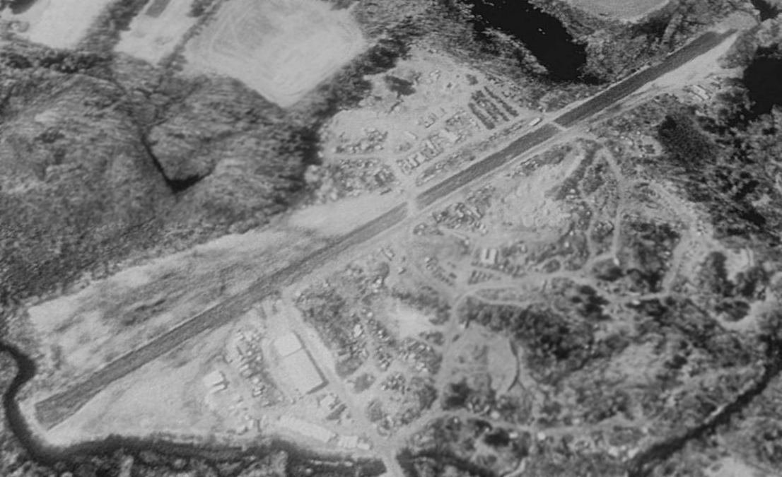
A 2019 aerial view of the site of Swift Airfield showed that much of the runway pavement had been removed, although some of the western portion remains,
along with several possible hangars on the northeast side.
Thanks to Alex Neisloss for pointing out this airfield.
____________________________________________________
41.49, -72.23 (Southeast of Hartford, CT)
Salem Airport, as depicted on the November 1945 NY Sectional Chart.
Salem Airport was not yet depicted on the January 1945 NY Sectional Chart.
According to the book Salem by Cindy Lee Corriveau, “The Salem Airport was opened in 1944.
During the war, a small airport had to be 10 miles away from the coast.
Raymond Gannoe leased the land from the Arrowitz family, who had used the land as a chicken farm.
He decided to open up his own airport with the financial help of Paul Destin & James Monroe.”
The earliest aeronautical chart depiction which has been located of Salem Airport was on the November 1945 NY Sectional Chart.
It depicted Salem as a commercial/municipal airport.
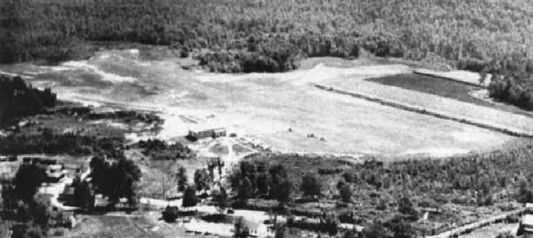
The earliest photo of Salem Airport which has been located was a 1946 aerial view looking southeast.
It depicted Salem as an irregularly-shaped grass field, with a hangar & several light planes on the northwest side.
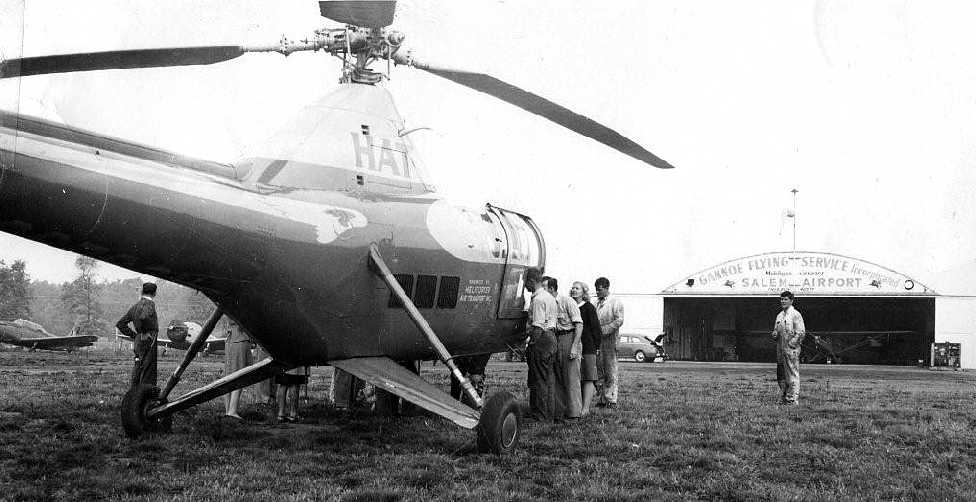
An October 1946 of a Sikorsky R-5 helicopter of Helicopter Air Transport at Salem Airport, with the Gannoe Flying Service hangar visible in the background (courtesy of Charles Czajkowski).
According to Charles, “The President of Pratt & Whitney Aircraft in East Hartford would commute to work on this helicopter from Fishers Island, NY.
This particular day was foggy so they landed here to wait out the fog.
My mother Jennie Czajkowski worked there as a secretary & she is the blonde person looking into the helicopter.
Her sister Genevieve Zielonka also worked at the airport part-time on weekends.”
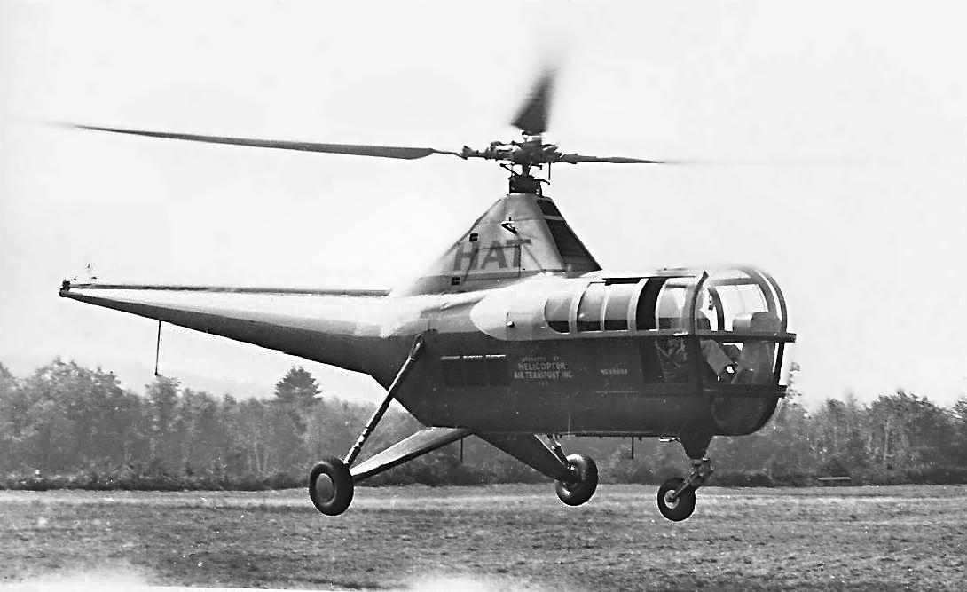
An October 1946 of the same Sikorsky R-5 helicopter departing from Salem Airport “after the fog lifted” (courtesy of Charles Czajkowski).
According to the book Salem by Cindy Lee Corriveau, “In 1947, with government sponsorship, Raymond Gannoe turned the airport into a flying school,
and it became known as Salem Airport & Gannoe Flying Service Incorporated.”
The earliest topo map depiction which has been located of Salem Airport was on the 1948 USGS topo map.
It depicted Salem as a commercial/municipal airport.
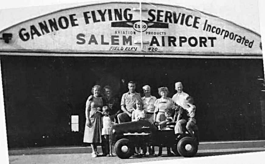
An undated photo of Raymond Gannoe (2nd from left) with family & airport workers in front of Salem Airport's Gannoe Flying Service hangar.
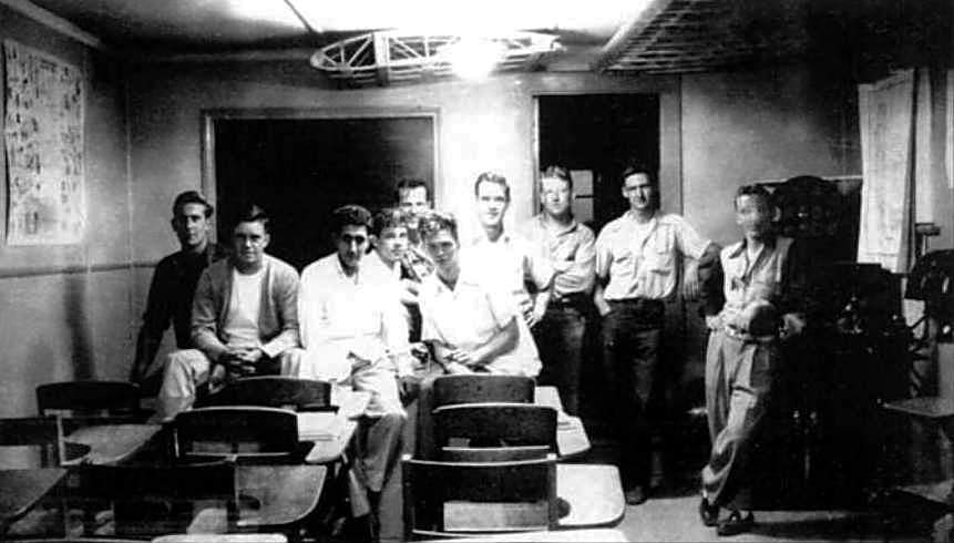
An undated photo of students inside Gannoe Flying Service's classroom at Salem Airport.
A 1949 aerial photo depicted Salem Airport as having a single hangar on the northwest side, near which were parked 3 single-engine aircraft.
According to the book Salem by Cindy Lee Corriveau, “Paul Zaehringer was one of the flight instructors.
In 1949 the government rescinded on its support of the flying school.”
Charles C. recalled, “Back in the 1950s my uncle was an instructor at this airport. It had a dirt runway.”
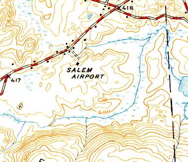
The last topo map depiction which has been located of Salem Airport was on the 1950 USGS topo map.
It depicted Salem Airport as a single building, without any other details.

The last photo which has been located of an aircraft at Salem Airport was a circa 1951 photo of Charles Czajkowski in front of a Piper Cub.
According to Charles, “The picture is me at about 4 years old so should be about 1951 (my mother had me dressed as Little Lord Fauntleroy).”
According to the book Salem by Cindy Lee Corriveau, Salem “airport fizzled out & closed in 1951.”
The last photo which has been located of Salem Airport was an 8/5/51 aerial view.
The airport may have been closed by this point, as no aircraft were visible on the field.
It remained intact though, including the single hangar at the northwest corner.
The last aeronautical chart depiction which has been located of Salem Airport was on the 1958 NY Sectional Chart,
even though Salem Airport may already have been closed by several years by that point.
It depicted Salem as having a 2,000' unpaved runway.
Salem Airport was no longer depicted at all on the January 1960 NY Sectional Chart.
The Salem Airport hangar was evidently removed at some point between 1951-70, as it was no longer visible on a 1970 aerial photo.
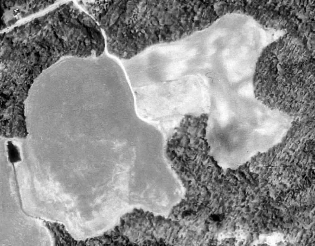
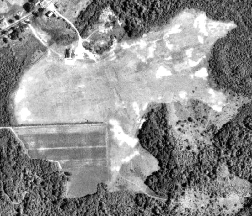
A 1991 USGS aerial view showed the site of Salem Airport to remain clear but not in active use.
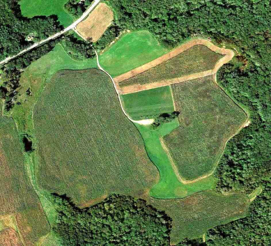
A 9/16/11 aerial view shows the site of Salem Airport remains clear.
The site continues to have an aviation use, albeit of a smaller variety, as in the center of the property is visible the flying field for the RC Propbusters model aircraft club,
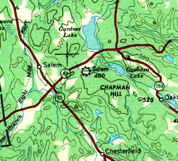
The site of Salem Airport is located southwest of the intersection of Norwich Road & Old Colchester Road.
____________________________________________________
Doane Airport / Essex Airport, Essex, CT
41.345, -72.413 (Southeast of Hartford, CT)
Doane Airport, as depicted on the August 1932 NY Sectional Chart.
Doane Airport was built in 1929-31 by Everett Doane for his son Bill, according to Richard Calarco.
“Young Bill was an experienced pilot who used the airport basically to provide flying lessons for student pilots -
also he would take passengers on sightseeing flights over the Valley Shore towns.”
The earliest directory reference to Doane Airport which has been located
was in the Pilot's Handbook Publishing Company's 1931 Pilots Handbook (courtesy of Chris Kennedy).
It described Doane as an auxiliary airfield, but did not give any other description of the field.
The earliest depiction which has been located of Doane Airport was on the August 1932 NY Sectional Chart,
which depicted Doane as a commercial/municipal airport.
The Airport Directory Company's 1933 Airport Directory (courtesy of Chris Kennedy)
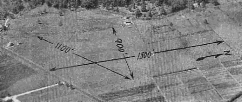
described Doane as a commercial airport, consisting of an irregularly-shaped sod field measuring 1,250' x 900'.
The earliest photo which has been located of Doane Airport
was a 1934 aerial view taken by the Fairchild Aerial Survey Company (courtesy of Chris Kennedy).
It depicted Doane Airport as having hangars located on the south & west sides.
An aerial view looking west at Doane Airport,
from the Airport Directory Company's 1938 Airport Directory (courtesy of Chris Kennedy).
The directory described Doane as a commercial airport consisting of a 30 acre irregularly-shaped sod field, measuring 1,300' x 1,100'.
Richard Calarco reported, “An article in the local paper indicated that Howard Hughes use to land there
to visit Katherine Hepburn who had a family house at the beach area in Old Saybrook.”
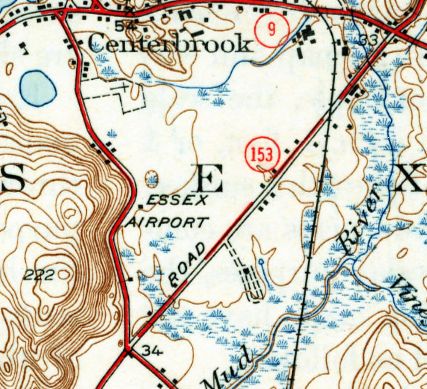
The 1944 USGS topo map depicted Essex Airport has a clearing with a few small buildings along its periphery.
A 10/28/42 aerial view looking north from the 1945 AAF Airfield Directory (courtesy of Scott Murdock) depicted Doane as an L-shaped grass field.
The 1944 USGS topo map labeled the site of the "Essex Airport", but did not depict any other details (no outline of the property or runways).
The 1945 AAF Airfield Directory (courtesy of Scott Murdock) described Doane Airport
as a 30 acre L-shaped property having 2 sod runways, measuring 1,250' north/south & 1,150' northwest/southeast.
The field was said to have a single 60' x 30' wooden hangar,
to be owned by private interests, but not to be currently in operation
(like many other small general aviation airports along the coasts during WW2).
The Haire Publishing Company's 1945 Airport Directory (courtesy of Chris Kennedy)
described Doane Airport as a "class s-1" field, owned, operated, and managed by E.W. Doane.
The field was said to have 2 grass runways (1,800' northeast/southwest & 1,250' north/south)
a hangar, and an administration building.
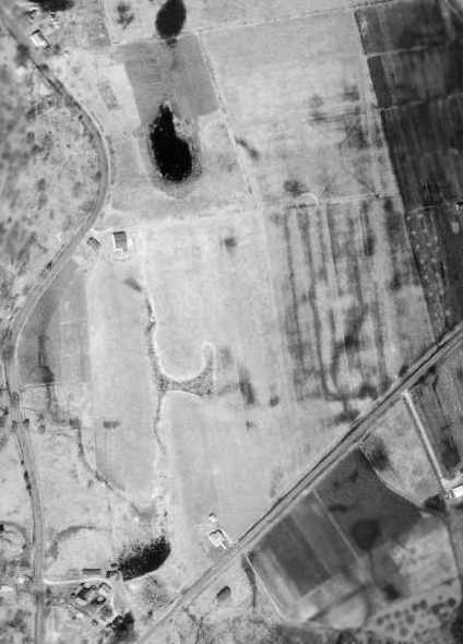
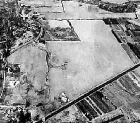
The last aerial photo which has been located showing Doane Airport still in operation was a 4/25/49 USGS aerial view.
It depicted an arch-roof hangar & a T-hangar on the west side.
It was still labeled “Essex Airport” on the 1951 USGS topo map.
Richard Calarco recalled, “I learned to fly out of Doane's airport in 1954 when I was 16 years old.
In a J3 Cub & Cessna 120 with no radios. The manager & my flight instructor was Everett Savard, a highly respected pilot in CT.
He leased the airport from Mr. Doane starting about 1951-52.
It had a short runway & we used the northeast/southwest runway most of the time & in the spring & winter it was very soft & marginal.”
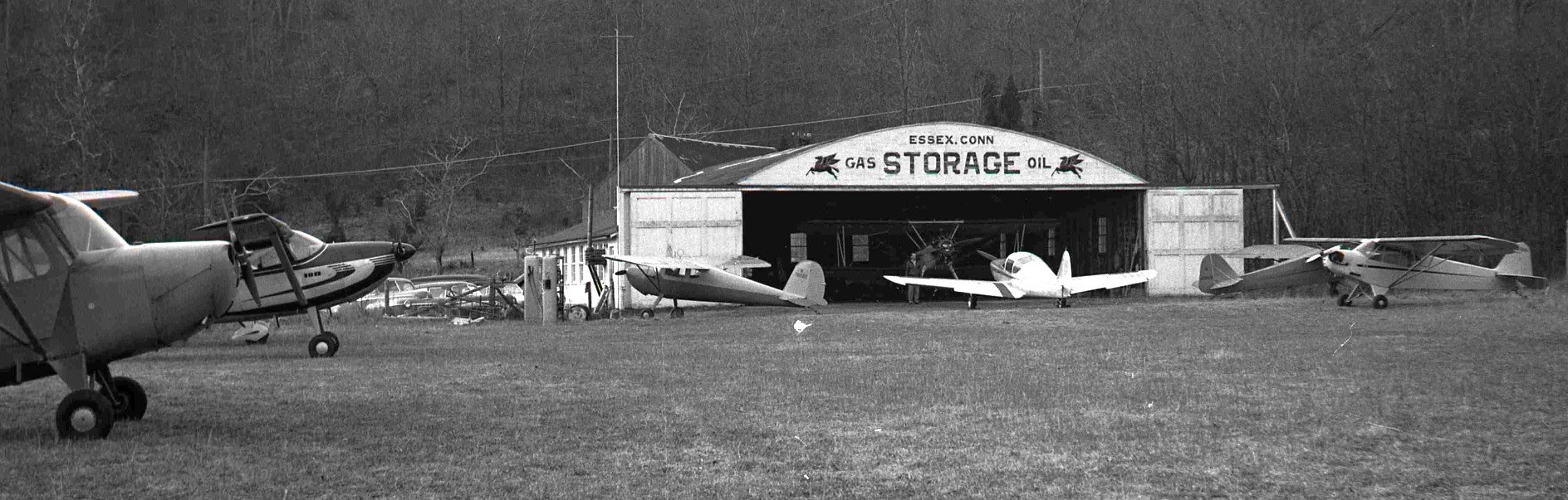
A December 1954 photo by George Otrin (courtesy of his great nephew Matthew Hovey) at Doane Airport,
showing a variety of 7 light single-engine general aviation aircraft in front & inside the hangar marked “Essex Conn, Gas, Storage, Oil”.
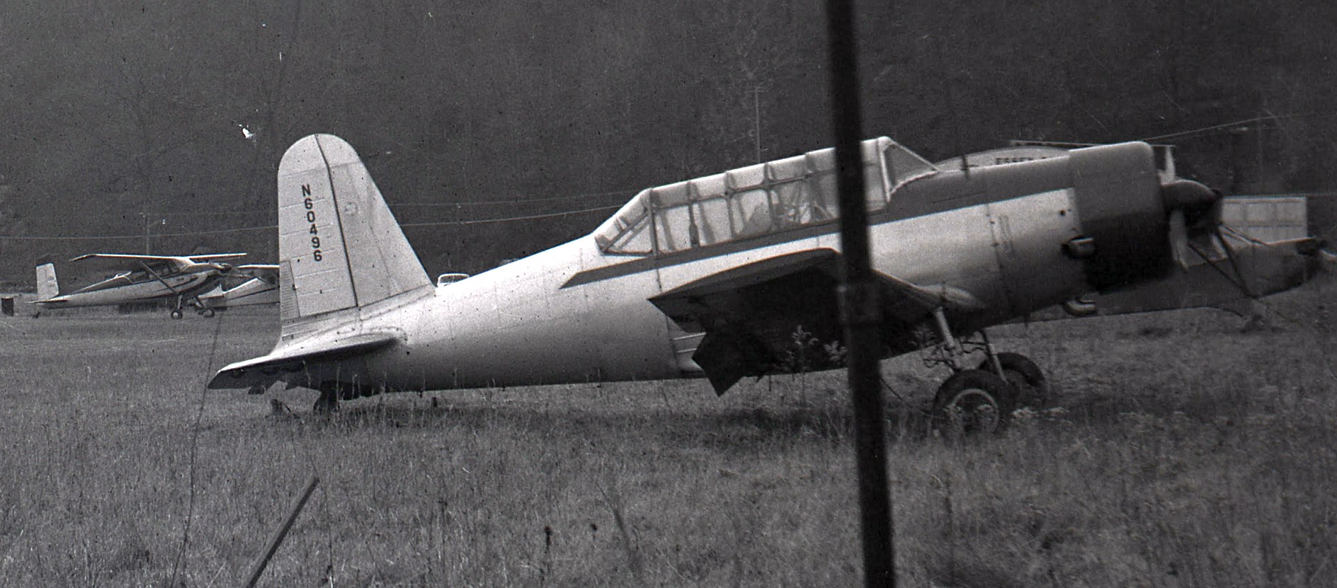
A December 1954 photo by George Otrin (courtesy of his great nephew Matthew Hovey) of N60496, a 1945 Consolidated Vultee BT-13B & other light aircraft at Doane Airport.
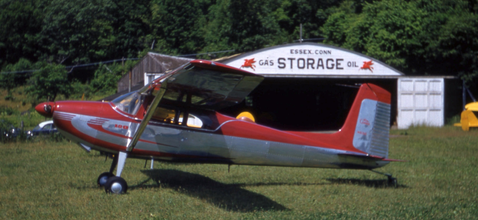
The last photo which has been located showing Doane Airport still in operation was a Summer 1955 photo by George Otrin (courtesy of his great nephew Matthew Hovey) of a beautiful Cessna 170 in front of the hangar.
The last depiction of Doane as an active airport which has been located was on the July 1955 NY Sectional Chart.
It depicted Doane as having a 1,900' unpaved runway.
Richard Calarco recalled, “The airport closed because they were going to develop the land but never did.”
Doane Airport was evidently closed at some point between 1955-56,
as it was no longer depicted at all on the January 1956 NY Sectional Chart or the 1958 USGS topo map.
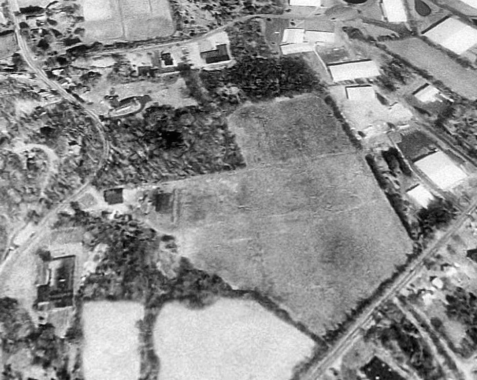
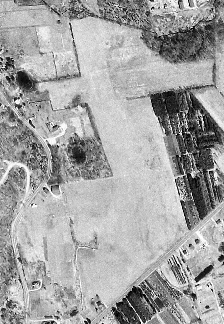
A 1991 USGS aerial view looking north showed the majority of the site Doane Airport to remain open & undeveloped, and the hangar remained standing on the west side.
Richard Calarco reported in 2005, “The old hangar is still there & the field is still there.
Every time I visit Essex, I go by the site & look at it & tell my wife that is where I learned how to fly.
She gets tired of it but goes along with it for my sake.”
Richard Calraco reported later in 2005, “The airport just sold the 23 acres this year 2005, to a local businessman for $725K.
This land has been vacant since the airport closed.”
However, Richard Calarco reported in December 2005, “The good news is that the folks that bought the airport & hangar
are going to restore the old hangar & try to make it look like the old days
and park an old antique aircraft outside trying recreate the old atmosphere.
From what I have found out the present owners do not plan on selling the land for development in the near future.”
A circa 2008-2011 aerial view looking west shows the Doane Airport hangar on the west side of the property,
and it appears to have been nicely restored.
Richard Calarco reported in 2013, “The land & layout is still there; no construction on the airport land.
The folks that bought the land & old hangar restored the hangar to make it look like the early flying days.”
A 2016 aerial view looking north showed some portions of the site Doane Airport to remain open & undeveloped, and the hangar remained standing on the west side.
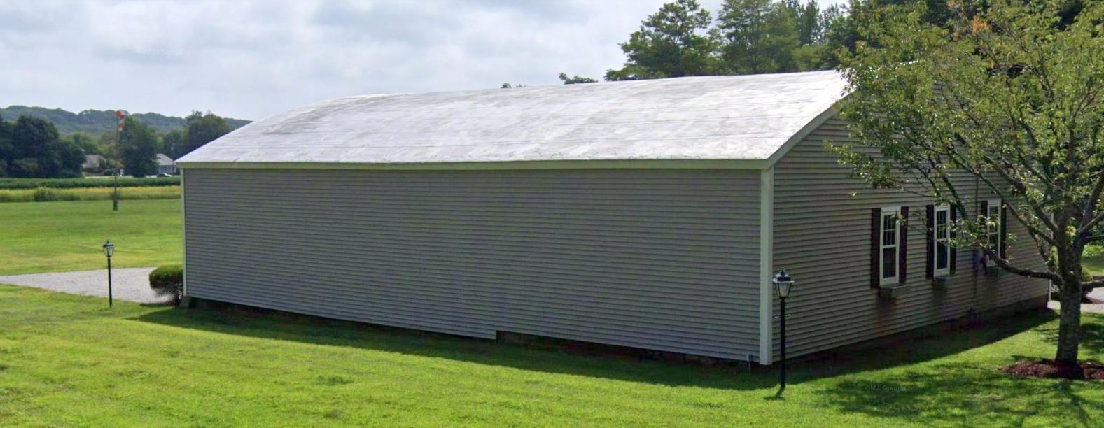
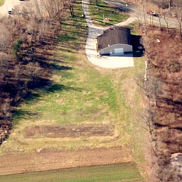
An August 2019 photo looking at the restored hangar on the west side of the Doane Airport site.
The site of Doane Airport is located north of the intersection of Route 153 & Westbrook Road.
____________________________________________________
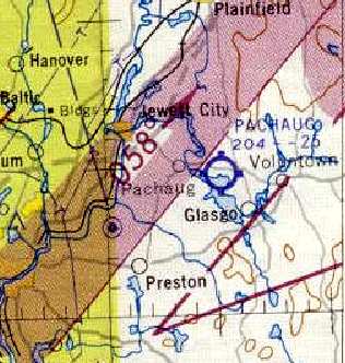
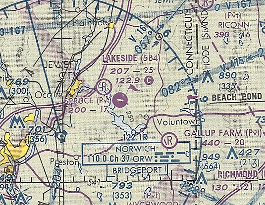
Pachaug Airport / Lakeside Airport, Pachaug, CT
41.58, -71.91 (Southeast of Hartford, CT)
Pachaug Airport, as depicted on the July 1949 NY Sectional Chart (courtesy of Ron Plante).
According to Lorraine (Sinkewicz) Piurowski, "My parents, William & Caroline Sinkewicz, bought the property around 1943 from the Latham family.
At that time, the property had been a farm."
Pachaug Airport was evidently established at some point in 1949,
as no airport at the location was depicted on the January 1949 Boston Sectional Chart.
The earliest depiction which has been located of Pachaug Airport
was on the July 1949 NY Sectional Sectional Chart (courtesy of Ron Plante),
which depicted Pachaug Airport as having a 2,000' unpaved runway.
Lorraine Piurowski recalled, "In 1954, my father had the house moved to where it now stands,
a move of about 2,500' from the opposite end. Soon after, he paved the runway.
He initially built a small concrete building that served as a gas station & his 'office'."
"I distinctly remember a time when, as a child, I accidentally through a rock through the side of my father's Piper Cub.
He had just finished putting new canvas on the body!
I also remember helping my father hold down planes in 1955 when a hurricane struck."
Pachaug Airport was depicted on the May 1955 Boston Sectional Chart (courtesy of Graeme Smith) as having a 2,500' runway.
The earliest photo which has been located of Pachaug Airport was an undated aerial view from the 1956 CT Airport Directory (courtesy of Bill Hecht).
It described Pachung Airport as having a 2,500' east/west sod runway, and listed the manager as William Sinkewicz.
Pachaug Airport was depicted on the 1958 NY Sectional Chart (courtesy of Norman Freed) as having a 2,500' runway.
The clearing of Pachaug Airport was depicted on the 1958 USGS topo map, but it was not labeled.
Lorraine Piurowski recalled, "As the business grew, my father added a restaurant & a small flight school."
In the 1960s the airport was known for its 'breakfast flights'
when pilots would fly in to the restaurant on the property my mother ran for eggs & bacon or ham."
The 1962 AOPA Airport Directory described Pachaug Airport as having a single 2,500' turf Runway 9/27,
and listed the operator as William & Caroline Sinkewicz.
Pachaug Airport was still depicted as an active airfield on the 1963 Boston Sectional Chart (courtesy of Mike Keefe).
A 1965 aerial view of Pachaug Airport (from the CT State Library, via Chris Kennedy)
depicted the field as having a single east/west grass runway.
A single hangar was on the northwest side of the field, and there was one light aircraft visible next to the hangar,
and 2 other light aircraft on the southwest side of the runway.
Pachaug Airport apparently went through a period of abandonment,
as it was not depicted at all on the 1965 NY Sectional Chart (courtesy of John Voss),
and was not depicted at all on the 1969 USGS topo map.
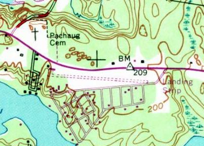
The 1970 USGS topo map depicted Pachaug as having an east/west unpaved “Landing Strip”.
Lorraine Piurowski recalled, "Later my father changed the name to Lakeside Airport."
That is how it was listed in the 1972 Flight Guide (according to Chris Kennedy).
Lorraine Piurowski recalled, "My father lived his dream of flying, and that love, which began as a young man in his 20s,
remained with him until his death in 1983.
He was no longer able to fly or instruct following several heart attacks, bypass surgery & a stroke."
Lakeside Airport was still listed as an active airfield in the 1985 Flight Guide (according to Chris Kennedy).
Charles Friedman recalled in 2008, “Some 20 years ago or so, my airplane partner & I
used to fly our Beechcraft Bonanza from Hartford to John Sinkewicz at Lakeside Airport
for annual inspections & other maintenance.
John was always thorough & knowledgeable about the aircraft.”
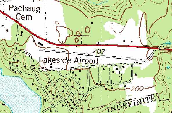
Lakeside Airport was depicted on the 1989 USGS topo map
as having a 2,500' paved east/west runway.
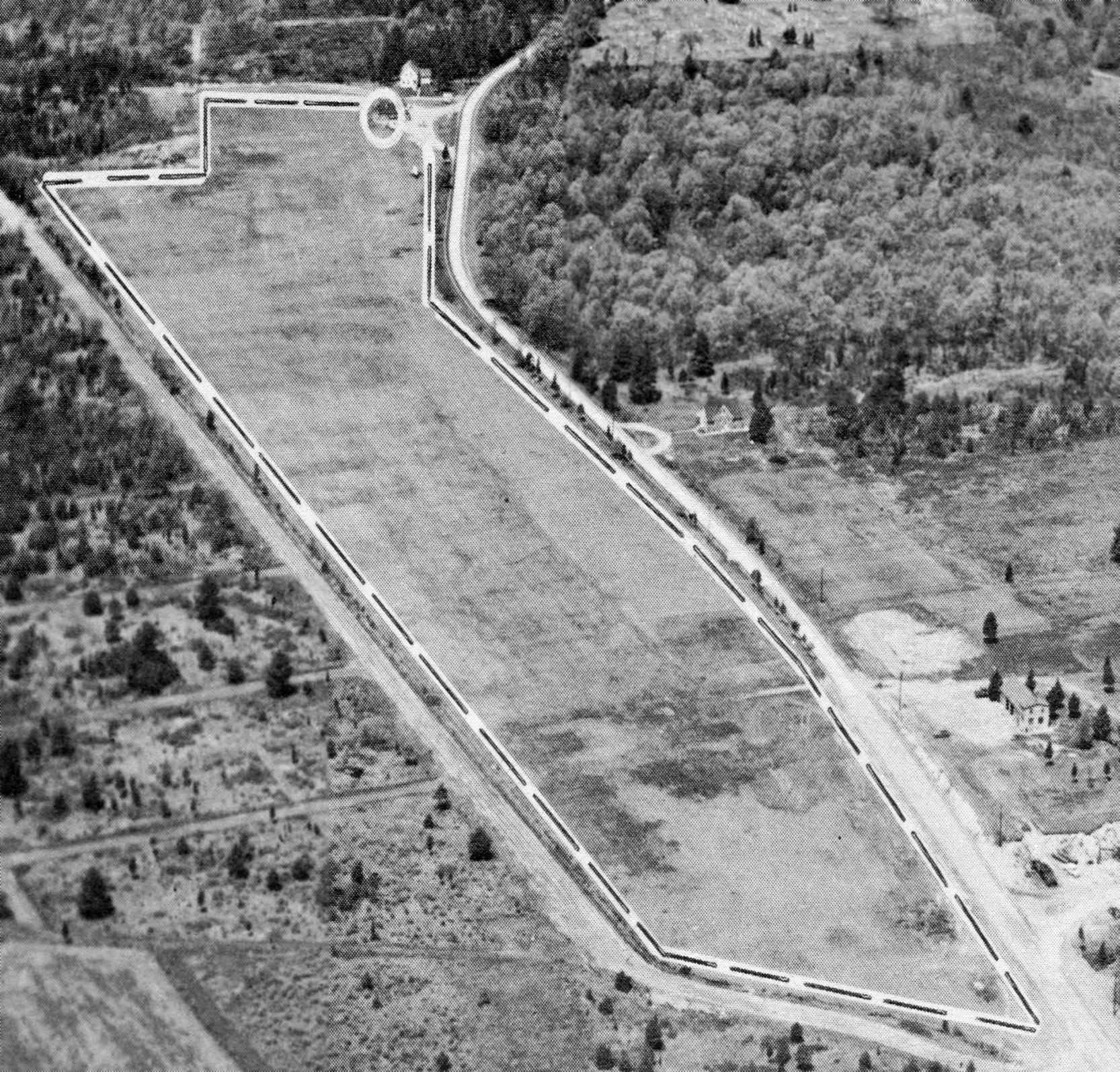
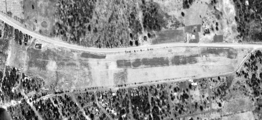
The last photo which has been located showing Lakeside Airport in operation was a 4/11/91 USGS aerial view looking northeast.
It depicted the field as having a single paved east/west runway.
A ramp with a small building sat on the northwest side of the field, and a total of over 20 light aircraft were parked on the field.
According to Lorraine Piurowski, "The airport remained as a working airport until my mother's death in 1993.
My brother, John Sinkewicz, operated an aircraft maintenance & repair business until that time.
Not too long after my mother's death, my brother retired & closed the business."
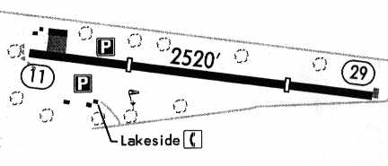
The 1993 Jeppesen Airport Directory depicted Lakeside as having a single 2,520' paved Runway 11/29,
with several small buildings on the northwest & southwest sides of the runway.
The last aeronautical chart depiction which has been located of Lakeside Airport
was depicted on the December 1993 NY Sectional Chart (courtesy of Ron Plante),
which depicted Lakeside as having a 2,500' paved northwest/southeast runway.
The 1994 Jeppesen Airport Directory still listed Lakeside as an active airport.
It depicted the field as having a single 2,520' paved Runway 11/29,
with a ramp on the northwest side, and several small buildings on the northwest & southwest sides of the runway.
Lorraine Piurowski recalled, "Not too long after my mother's death [1993], my brother retired & closed the business."
Lakeside Airport was no longer listed among active airfields in the 2000 AOPA Airport Directory.
Lakeside Airport was depicted as an abandoned airfield on the 2003 Sectional Aeronautical Chart.
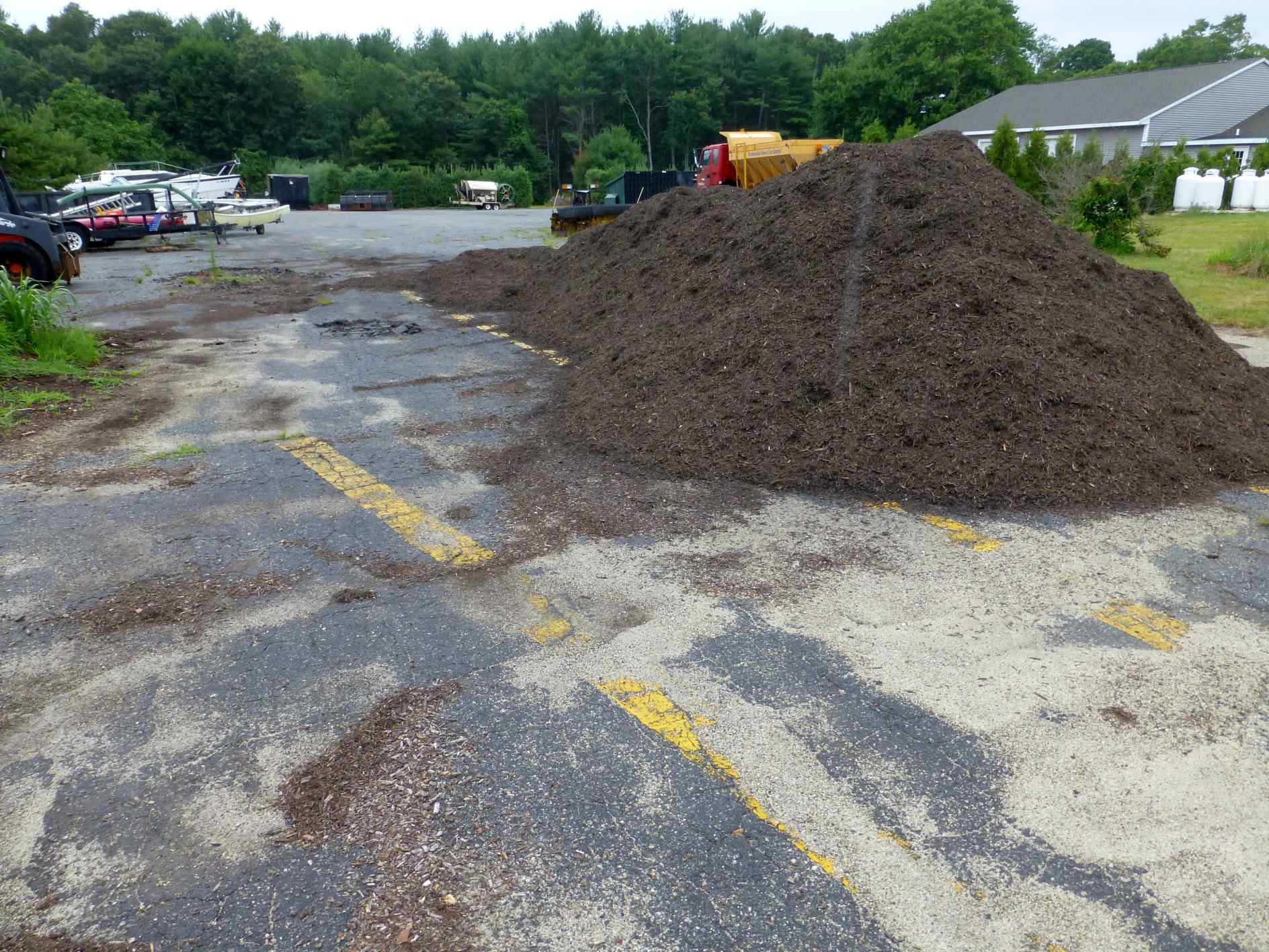
Marc Dodge reported in 2003, "I went by there a few weeks ago & saw that a storage building (rental units) has been built in the middle of the runway.
The hangar is still there though.
I understand that the Town of Griswold has expressed an interest in purchasing the remainder of the property on the eastern end - for what I don't know."
Charles Friedman observed, “It was interesting for me to read about how it has since been turned into storage space for the masses.
An abandoned airfield turns into the holder of abandoned property - is this a parody of modern times?”
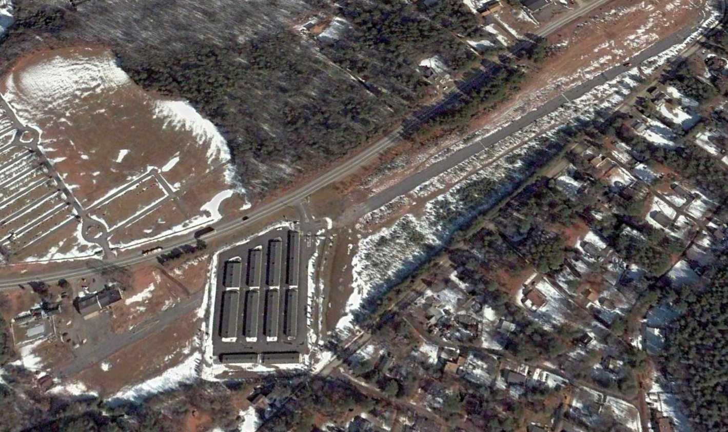
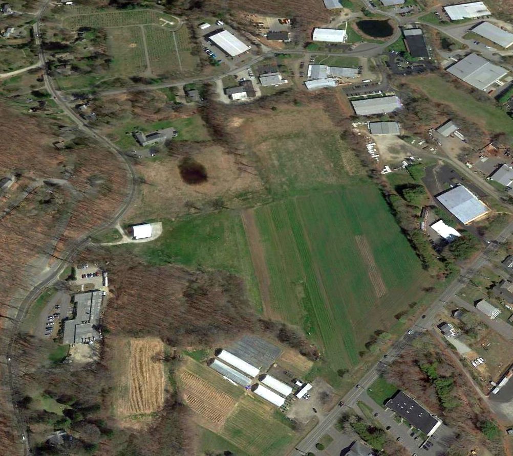
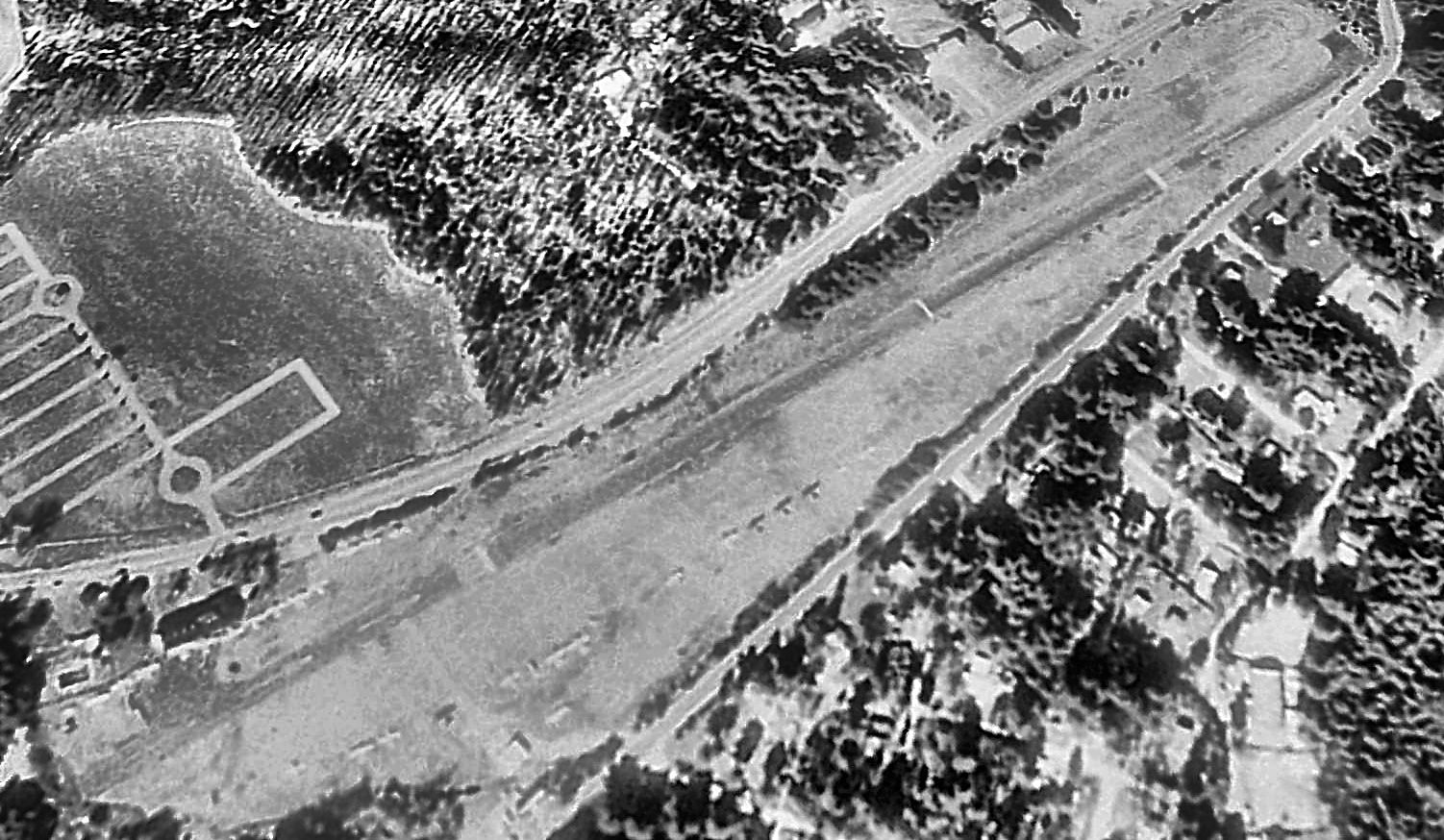
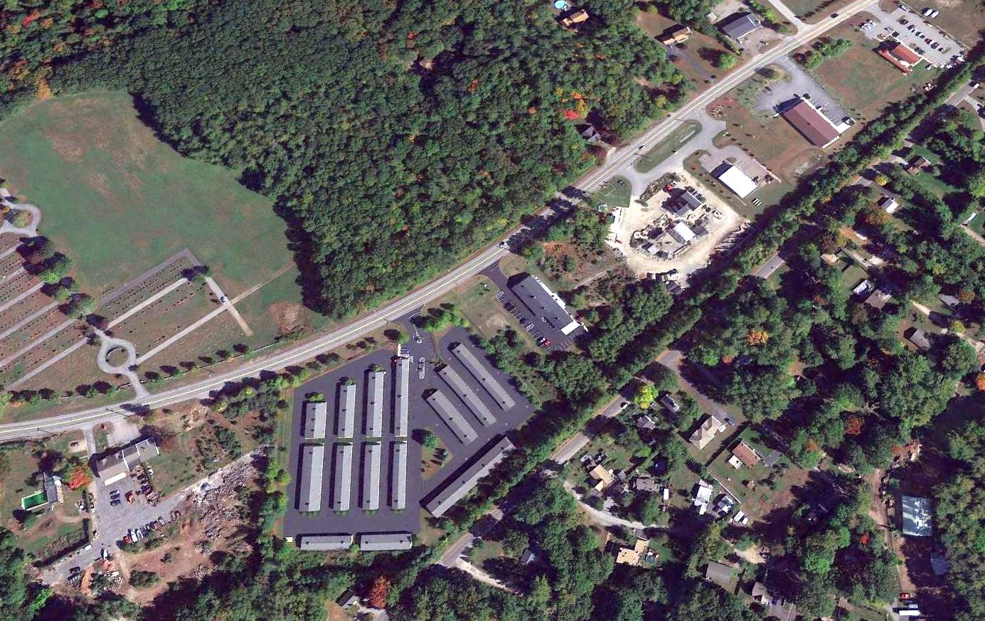
A 2005 aerial view looking northeast at the site of Lakeside Airport showed the storage units having been built over the center of the runway,
but the majority of the runway pavement remained intact.
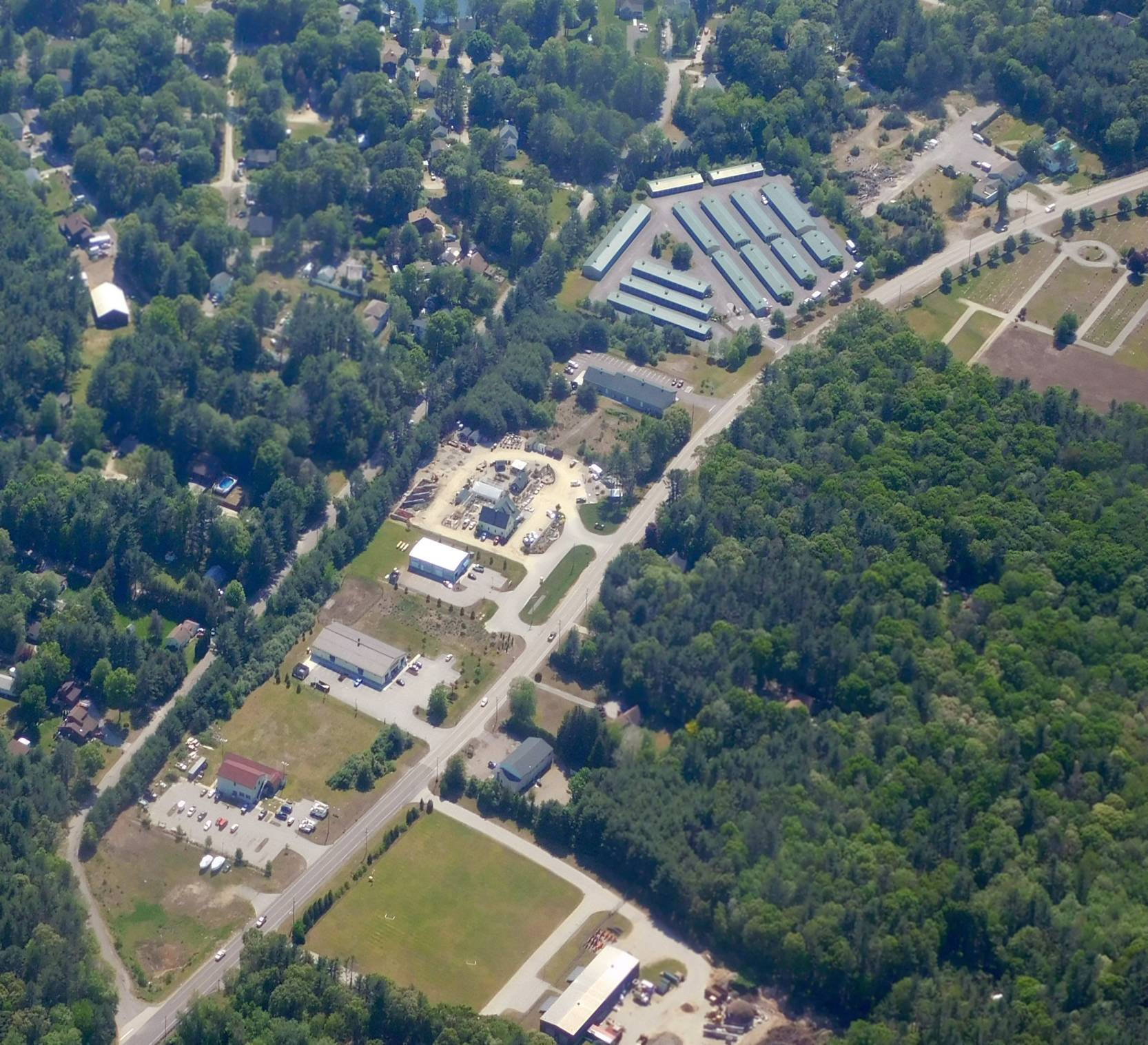
A circa 2008-2011 aerial view looking east showed the western portion of the Lakeside Airport runway remaining.
A 2015 photo by Michael LaRose looking northwest at the remaining western portion of the Lakeside Airport runway, including the yellow displaced threshold marking, and former airport office.
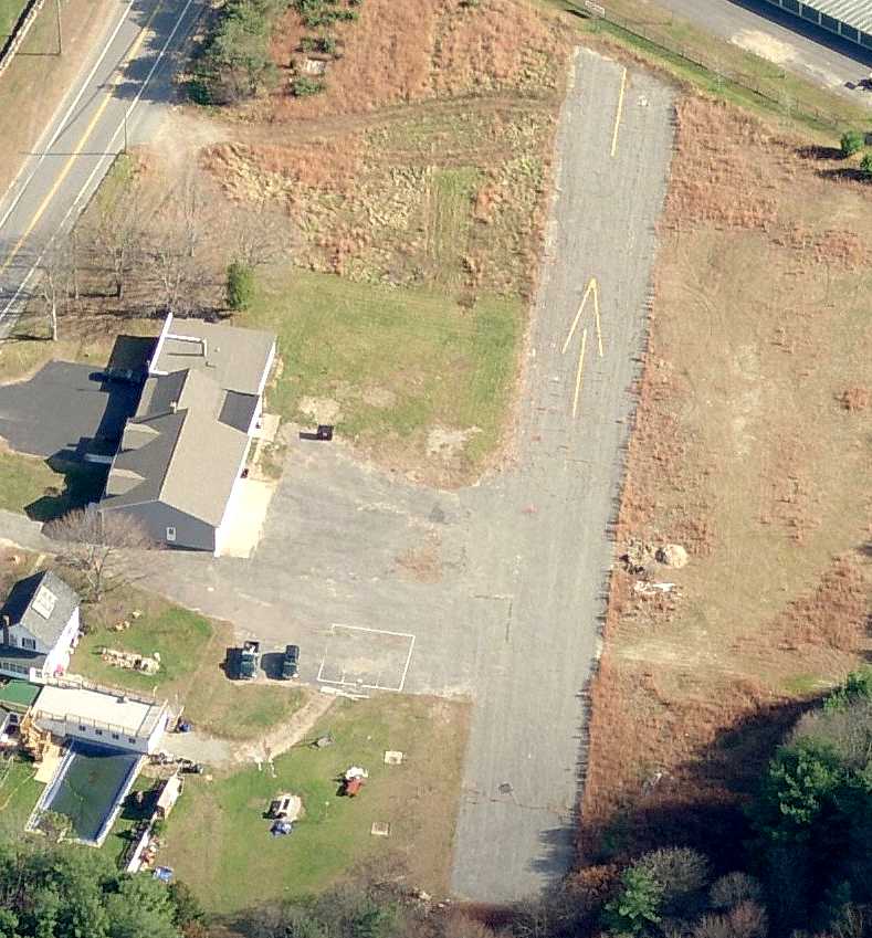
A 2016 aerial view looking northeast showed the majority of the Lakeside Airport runway had been built-over, but a few hundred feet of the west end of the runway remained,
along with the former airport building (bottom-left).
A 5/24/18 aerial view by Carl Stidsen (courtesy of Tom Moorehouse) looking southwest at the site of Lakeside Airport.
The last remaining portion of the runway pavement can be seen at top-right.

A 3/5/20 photo by Kevin Bachand of the remains of the last bit of the Lakeside Airport runway.
The site of Lakeside Airport is located southwest of the intersection of Voluntown Road & Lathams Drive.
Thanks to Chris Kennedy for pointing out this airfield.
____________________________________________________
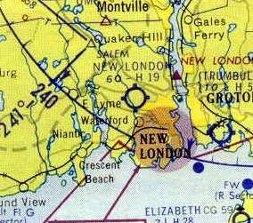
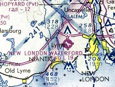
Waterford Airport / New London Waterford Airport, New London, CT
41.364, -72.146 (Southeast of Hartford, CT)
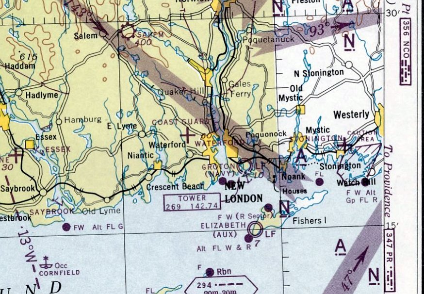
Waterford Airport, as depicted on the November 1945 NY Sectional Chart.
Waterford Airport was not yet depicted on a 1934 aerial photo.
According to Dennis Boykin, “The field was first established sometime in the late 1930s, and was always privately owned.”
However, Waterford Airport was not yet depicted on NY Sectional Charts from 1936/38/40 thru June 1945 ,
nor listed among active airfields in the 1945 AAF Airfield Directory (courtesy of Scott Murdock).
The earliest depiction which has been located of Waterford Airport was on the November 1945 NY Sectional Chart.
It depicted Waterford Airport as an auxiliary airfield.
The July 1949 NY Sectional Chart depicted New London Waterford Airport as having a 2,000' unpaved runway.
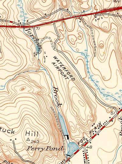
The 1949 USGS topo map labeled the site as "Waterford Airport", but did not depict any runways or other features.
An aerial view looking north at New London Waterford Airport,
from the 1956 CT Airport Directory (courtesy of Stephen Mahaley).
The directory described New London Waterford Airport as having two 1,800' gravel runways,
oriented north/south & northwest/southeast.
However, the runways were soon to be paved, as the remarks said "Hard surface runways being constructed."
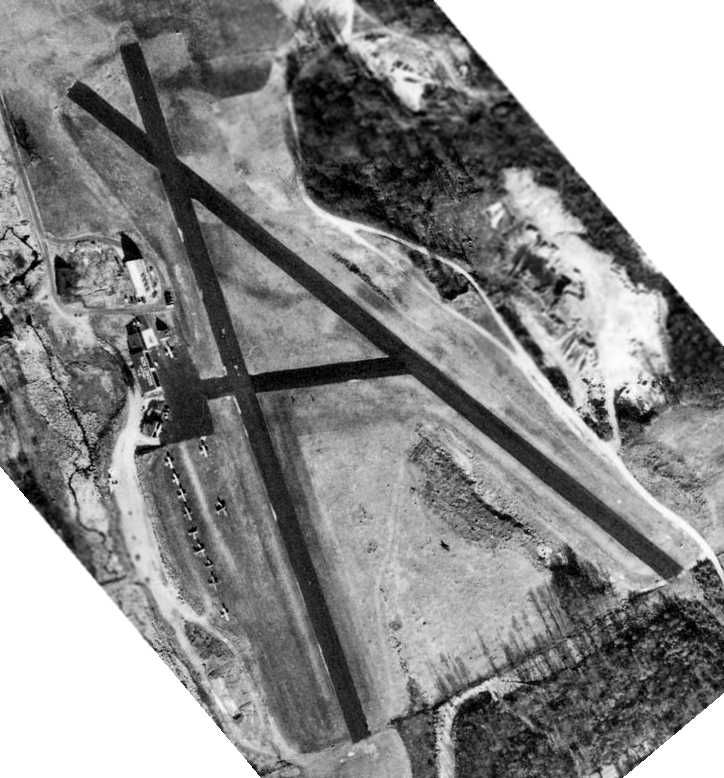
A taxiway led to a ramp on the west side of the field with a hangar & other buildings.
The operator was listed as New London Flying Service, and the manager was listed as Russell Corser.
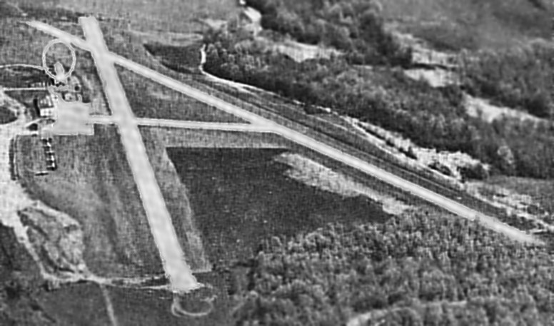
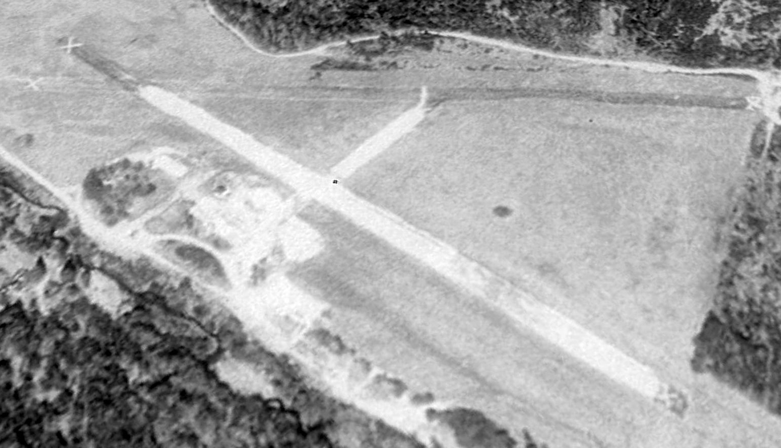
Within the next year, the runways at New London Waterford Airport had been paved in asphalt,
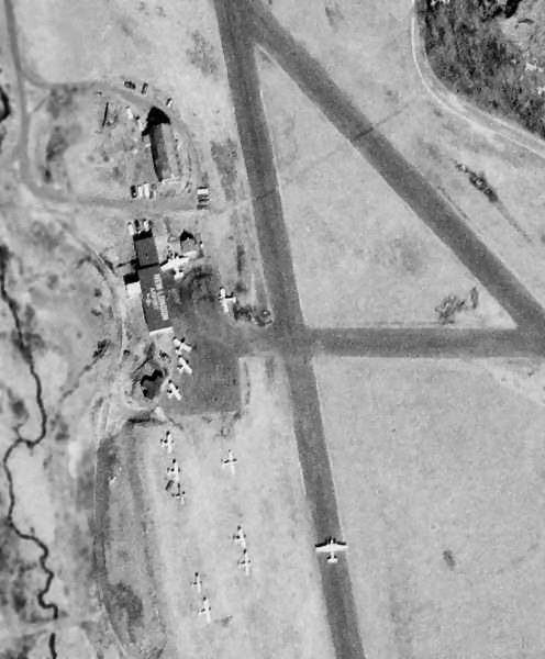
as seen in the above 1957 government aerial survey photo (courtesy of Jonathan Westerling), which looks east at the field.
A total of 15 aircraft were visible parked outside in the 1957 photo.
New London Airport, as depicted on the 1958 NY Sectional Chart (courtesy of Norman Freed)
as having a 1,900' hard-surfaced runway.
The 1960 Jeppesen Airway Manual (courtesy of Chris Kennedy
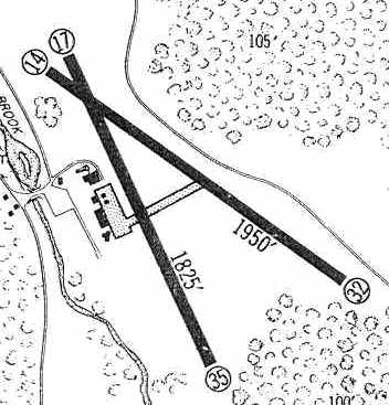
depicted New London Airport as having 2 paved runways: a 1,950' Runway 14/32 & a 1,825' Runway 17/35.
New London Waterford was listed among active airports in the 1962 AOPA Airport Directory,
with two 1,900' paved runways, and the operator listed as New London Flying Service.
Pete Simmons recalled, “Waterford Airport... I learned to fly there around 1963. In a Piper Colt at first, then they got a Cherokee 140.
Bertha Meana was my instructor. She was at least 65 at the time; I was a 15 year old kid.
I remember her yelling 'You fly the plane! Do not let it fly you!'
In the clean-out door of the chimney there usually was a key to an old vehicle pilots could use when needed.
Learn to fly there, with 1,800' & slope coming in over 95, and you could fly anywhere.
I remember Pilgrim Air with their D-18s & later Otters. The D-18s were exciting to watch.”
A 1965 aerial view of New London Waterford Airport (from the CT State Library, via Chris Kennedy).
Stephan Wilkinson recalled, “In August 1967 I did my initial flight training at Waterford, and Berth Meana was my excellent instructor. She was in her 70s by then.
Piper was paying for my flight time - I was writing a magazine article - and I assume they assigned me to fly at Waterford because of the newsworthiness of having a 75-year-old woman instructor.
The day I arrived for my first flight, a Twin Beech had just returned from JFK. It was owned by Pilgrim Airways, based at Waterford.
The D-18 had flared to land at JFK, and the pilot heard the ticking of the props hitting the concrete - he’d forgotten to put the gear down.
He horsed the yoke back just in time & flew back to Waterford with all 4 prop tips curlicued. He was of course immediately fired.”
Dennis Boykin recalled, “I took my first private aircraft flight (in a Piper Cherokee D) from Waterford Airport in 1967,
piloted by a friend's dad who flew cargo 747s for Flying Tiger lines.
At the time, it was an extremely active field, home to over 30 singles & twins,
numerous homebuilts, a Stearman or two, and one very old & abandoned Republic Seabee.
A charter service offered flights to Fisher's Island, Block Island, Martha's Vineyard, and Nantucket on a regular basis.
There were two runways: 2,100' & 1,900'.
Departing to the north required following a notch in the hillside immediately on the north side of I-95.
It was a great field to fly out of, with some really wonderful people keeping aviation alive.”
Dennis continued, “There were 2 or 3 hangars, an operations building out by the fuel pumps,
and a house, which at one time was rented by one of my high school teachers.
I became somewhat of a hangar rat & actually had my high school yearbook picture taken in a Pietenpol.
The interesting start of the end was the construction of homes immediately south of the field by 5 partners, 4 of whom worked at Electric Boat in Groton.
They subdivided & sold lots on the east side of their property to fund the development.
Allegedly, 3 of the 5 owned planes or flew from the airport, thus the dirt road to the west of the property.
Here comes the irony: The residential development was built specifically because the airport was there.
And the airport eventually closed, specifically because the houses were built there.
In the late 1960s & early 1970s, those families transitioned out,
and the homes closest to the field were sold to people who didn't like the airport.
First, complaints to the airfield operator, which resulted in prioritizing takeoff to the north.
Then, petitions to stop night flights (which were pretty rare anyway).”
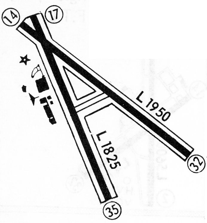
The 1968 Flight Guide (courtesy of Bob Levittan) depicted New London Airport as having 2 paved runways: a 1,950' Runway 14/32 & a 1,825' Runway 17/35.
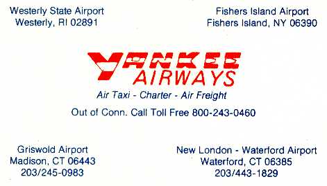
A circa 1974-77 business card for New London's Yankee Airways (courtesy of Ted Frison).
Ted Frison recalled, “New London / Waterford Airport... I flew out of there from 1974-77 as a part-time flight instructor & charter pilot.
At that time it was pretty busy. The FBO went by the name of Yankee Airways.
There was a nice community feel about the airport. Eddie Peese had a Stearman PT-17 & was gracious about taking everyone up for a lesson.
A mainstay of Yankee's business was running people out to Block Island (on a good Saturday, I could make 5 or 6 runs).
We had a lot of primary students whose instruction was paid for by the government.
By that time, I was tired of primary instruction & confined my time to teaching instruments & the charter flights.
On one of Part 135 check rides, I got an inspector who was in an unusually good mood & he offered to run me through the paces for an instrument endorsement.
That was great because there was only one other 135/instrument pilot at Yankee & he was pretty much an 8am-5pm employee because he had a family.
So, I got a lot of good night runs up to Boston & down to the NYC area in squirrely weather.”
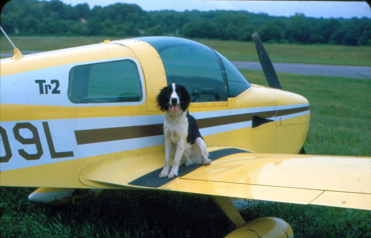
A circa 1975 photo by Ted Frison of his Grumman AA1B at Waterford Airport. Ted reported, his “copilot was Sludge dog. Dumb as dirt, but loved to fly.”
New London Waterford Airport, as depicted on the 1975 NY Sectional Chart (courtesy Mike Keefe).
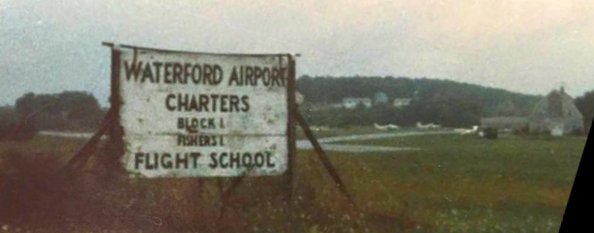
A circa 1970s/80s photo (courtesy of Bob McGrath via Tom Bush) of a sign for Waterford Airport.
According to Dennis Boykin, “By the 1980s, full scale zoning wars were underway to stamp out those pesky little airplanes.”
Dennis continued, “I did a checkout (from Groton) in a Piper Tomahawk in 1984,
and sucked some ice/water through the carburetor on climbout after we stopped & bought gas there [Waterford].
It was a bit scary being right over the houses on the south end.
After landing, I heard the stories about the zoning issues.
The local homeowners got themselves appointed & elected to the proper positions.
Soon, the property was rezoned as prime commercial land, with the attendant increase in taxes.”
Dennis continued, “I rented a Warrior in the summer of 1986 to fly to Martha's Vineyard, and things were pretty grim for the operator.
Taxes continued to increase, the aviation industry was in the throes of the litigation mess, and generally it didn't look good.
I came back in a real scud-running mode, and the lack of an ILS that close to the coast also hurt traffic.”
Dennis continued, “The property owner sued the Town of Waterford for changing his zoning without his consent.
He lost at the Connecticut Supreme Court, which precipitated the eventual closure of the field because he couldn't afford to pay full commercial tax rate.
By 1988, the owner finally was forced to sell out, caving into the pressure of the Town Fathers, who saw a great & wonderful light industrial park in their future.
The sad state of affairs, of course, is that the homeowners got their selfish wish, and there is absolutely no noise at all coming from the property.
The first developer put up big signs, tore down the buildings, and nothing happened.
Absolutely nothing has been accomplished, and the plans of the town to garner all this additional revenue have come to naught.”
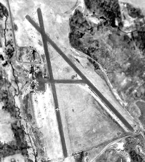
A 1991 USGS aerial view looking northeast showed the former Waterford Airport's paved runways still remained intact, although marked with closed-runway “X” symbols.
All of the buildings/hangars had been removed, though, from the ramp on the west side of the property.
Waterford was no longer depicted at all (even as an abandoned airfield) on the 1998 World Aeronautical Chart.
Dennis Boykin reported in 2001, “The airport property is still vacant...
a monument to the failure of the local pilots in reacting to organized resistance.
To see the property, take the Crossroads exit off I-95 five miles west of New London, and use the southern frontage road.
You can see the field (and the runways) as you drive past the weigh station eastbound. It's more difficult to see westbound.”
Dennis continued, “The original commercial buyer went bankrupt,
and the new owner has had absolutely no success save a single leased site on the northwest corner of the property (which was always woods) built in 2011.”
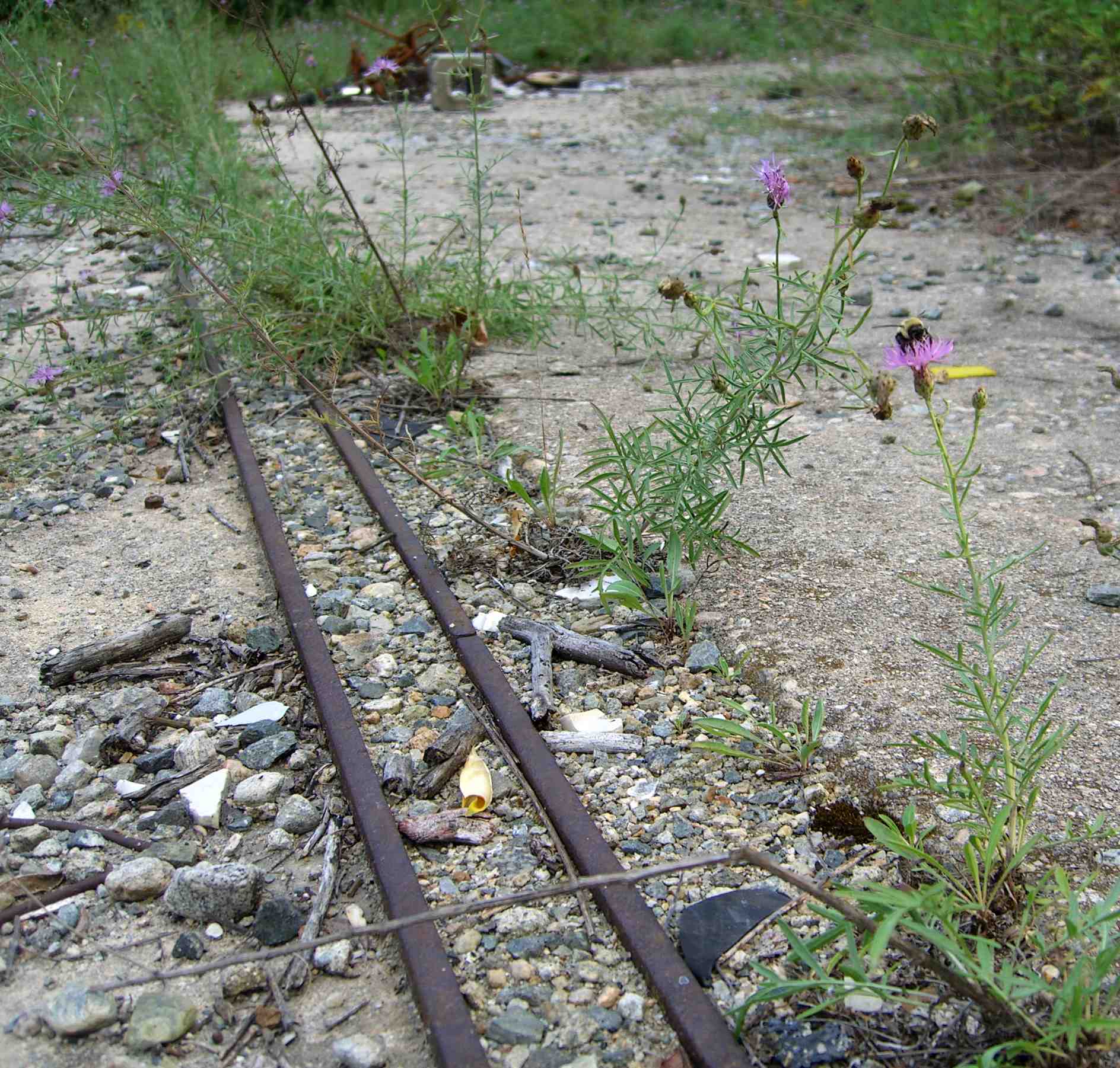
A circa 2008-2011 aerial view looking west showed the sole building remaining at the site of New London Airport, with the remains of the runway pavement in the foreground.
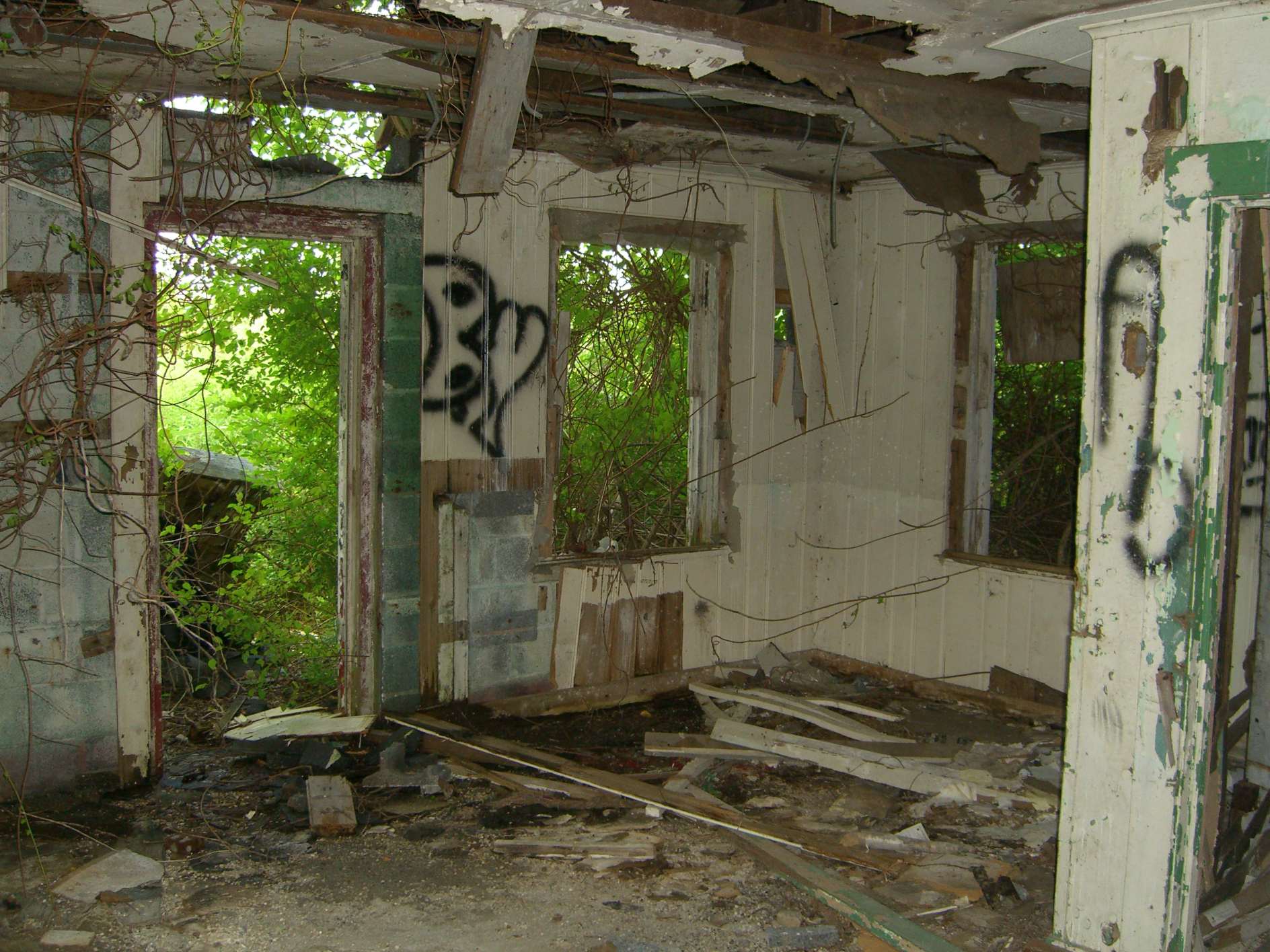
An 8/8/13 photo by Michael LaRose of the interior of the former New London Airport office.
An 8/8/13 photo by Michael LaRose of a hangar door rail at the New London Airport site.
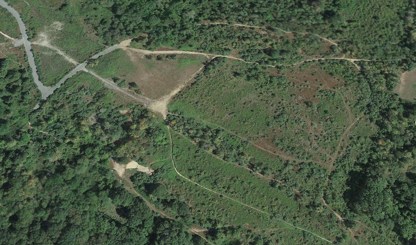
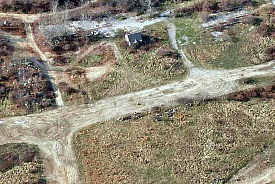
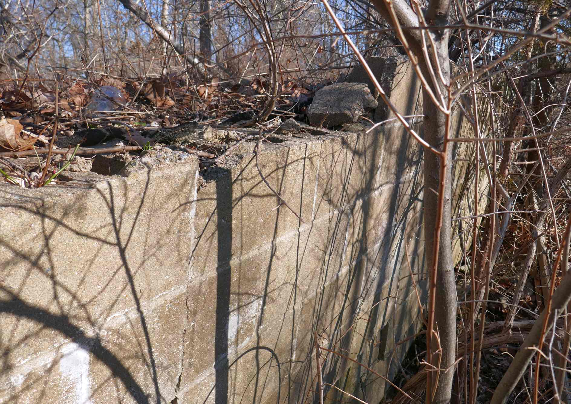
A 2017 aerial view looking northeast showed the Waterford Airport property was unrecognizable as a former airfield,
with only a portion of the runway pavement remaining (top-left of center of photo).
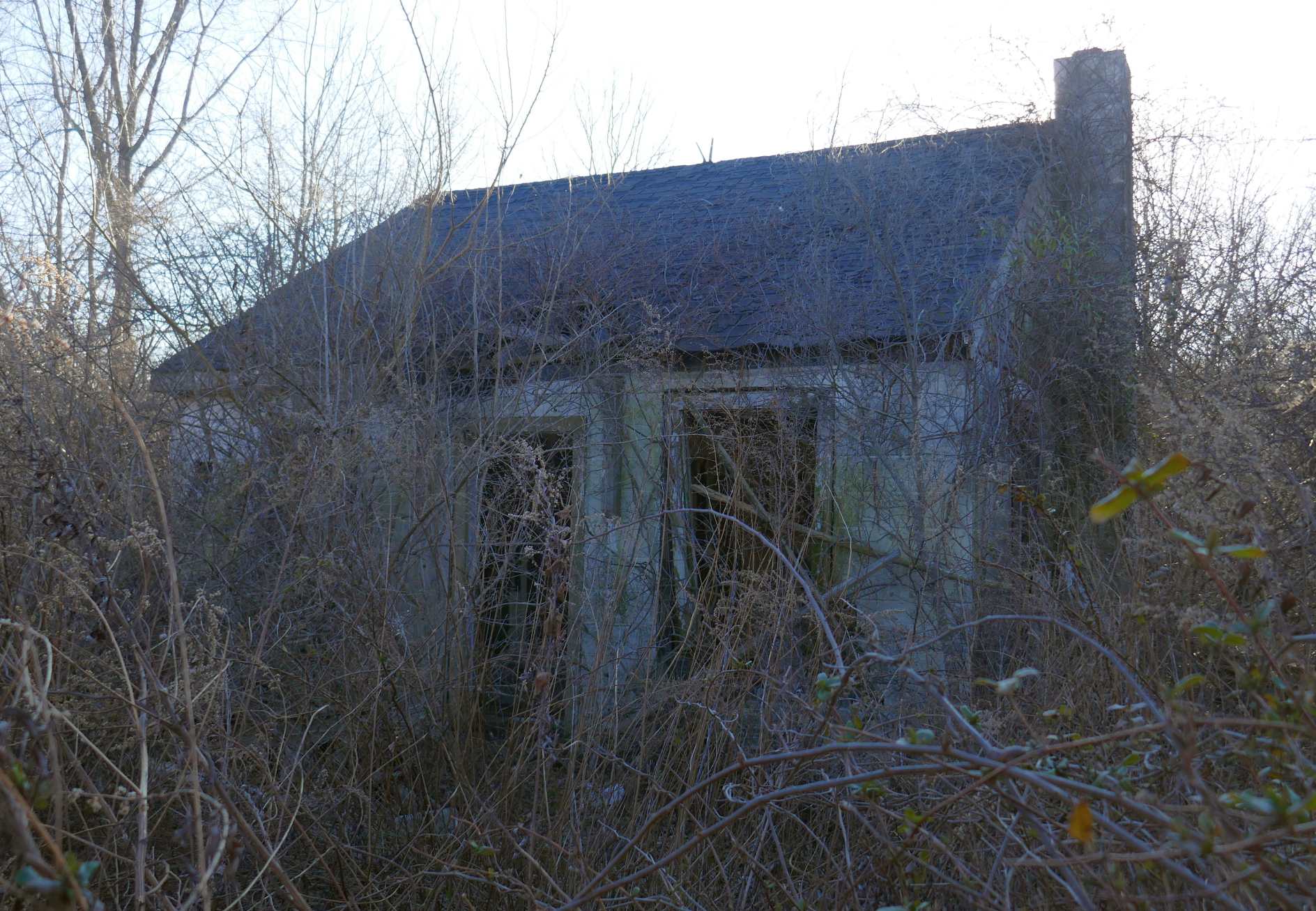
A 3/9/20 photo by Michael LaRose of the remains of the New London Airport office building.
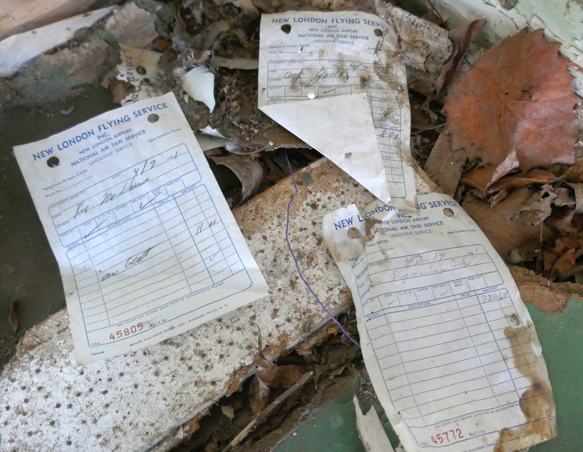
A 3/9/20 photo by Michael LaRose of 1961 New London Flying Service receipts laying scattered at the New London Airport site.
Michael LaRose reported, “There are quite a few receipts still in there.”
A 3/9/20 photo by Michael LaRose of the remains of a New London Airport hangar.
____________________________________________________
Since this site was first put on the web in 1999, its popularity has grown tremendously.
If the total quantity of material on this site is to continue to grow,
it will require ever-increasing funding to pay its expenses.
Therefore, I request financial contributions from site visitors,
to help defray the increasing costs of the site
and ensure that it continues to be available & to grow.
What would you pay for a good aviation magazine, or a good aviation book?
Please consider a donation of an equivalent amount, at the least.
This site is not supported by commercial advertising –
it is purely supported by donations.
If you enjoy the site, and would like to make a financial contribution,
you
may use a credit card via
![]() :
:
Please consider checking the box to make a monthly donatation.
For a mailing address to send a check, please contact me at: paulandterryfreeman@gmail.com
If you enjoy this web site, please support it with a financial contribution.
please contact me at: paulandterryfreeman@gmail.com
If you enjoy this web site, please support it with a financial contribution.
____________________________________________________
This site covers airfields in all 50 states.