
Abandoned & Little-Known Airfields:
Colorado: Southwestern Denver area
© 2002, © 2024 by Paul Freeman. Revised 9/1/24.
For a 7th year, the CO pages of this website are sponsored by the Colorado Pilots Association:
____________________________________________________
Please consider a financial contribution to support the continued growth & operation of this site.
Bar None Airport (added 11/16/18) - Columbine Airport (revised 3/22/22) - Flying C Ranch Airfield / Littleton Airport (revised 9/1/24)
____________________________________________________
Bar None Airport, Centennial/Littleton, CO
39.58, -104.98 (South of Denver, CO)
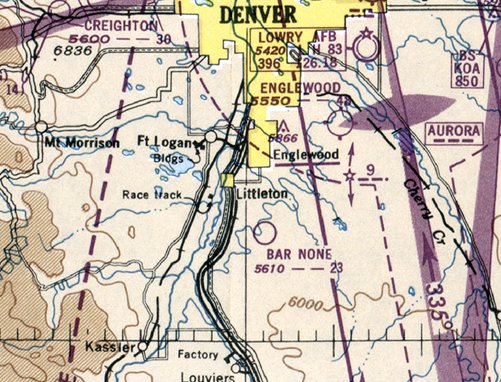
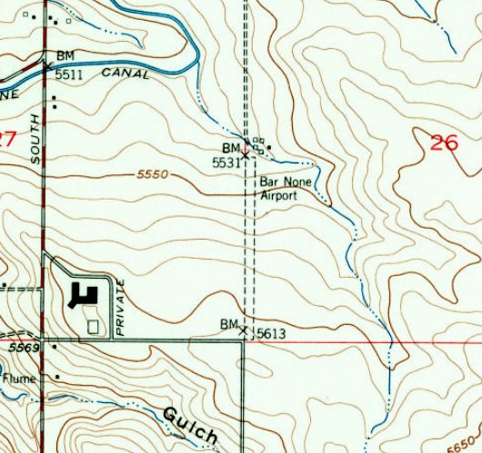
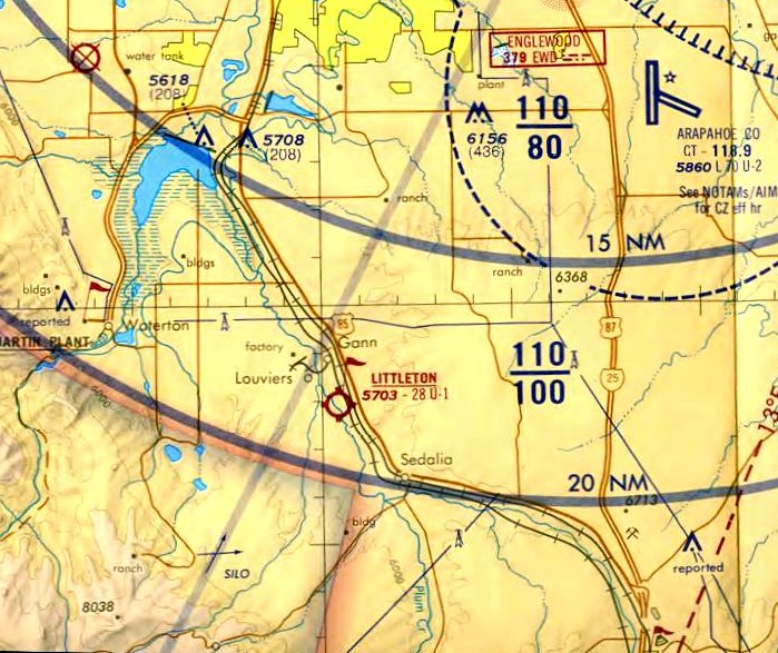
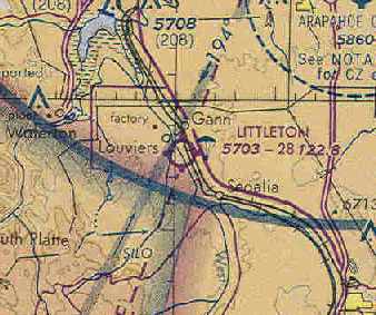
Bar None Airport, as depicted on the 1949 Denver Sectional Chart (courtesy of Jim Urdea).
This small general aviation airport was evidently established at some point between 1948-49,
as it was not yet depicted on the August 1948 Denver Sectional Chart.
The earliest depiction which has been located of Bar None Airport was on the 1949 Denver Sectional Chart (courtesy of Jim Urdea).
It depicted Bar none as having a 2,300' unpaved runway.
Jim Urdea noted, “It probably came into existence shortly after the end of WW2 with the rise in the popularity of general aviation.”
The earliest photo which has been located of Bar None Airport was a 9/25/53 USGS aerial view (courtesy of Jim Urdea).
It depicted a single north/south unpaved runway, with a few small buildings on the northeast side.
A 1954 aerial view looking southwest depicted Bar None Airport as having a single north/south unpaved runway, with a few small buildings on the northeast side.
According to Jim Urdea, “The area was surveyed for the 1954 Coast & Geodetic Survey when 2 markers, KK0469, KK0470 were placed near the hangars & windsock,
and a third, KK0471, at the southwest corner of the runway. KK0469 & KK0471 were recovered in 1955.”
The 1955 Denver Sectional Chart (according to Jim Urdea) showed that Bar None's runway length had increased to 2,600', with some refueling & repair facilities available.
The October 1956 Denver Sectional Chart (according to Jim Urdea) showed that Bar None Airport had been further improved with runway lighting.
The last aeronautical chart depiction which has been located of Bar None Airport was on the May 1957 Denver Sectional Chart.
It depicted Bar None as having a 2,600' unpaved runway.
The 1957 USGS topo map (courtesy of Jim Urdea) depicted Bar None Airport as having a single north/south unpaved runway, with a few small buildings on the northeast side.
Jim Urdea reported, “County records show the land being sold several times in the 1957-59 timeframe
with one of the purchaser-partners being Helen Bonfils, the daughter of the former Denver Post owner & publisher Frederick Bonfils.”
Bar None Airport was evidently closed at some point between 1957-60,
as it was no longer depicted on the June 1960 Denver Sectional Chart.
According to Jim Urdea, “Residential development [on the site of Bar None Airport] began in the early 1960s.
All 3 Coast & Geodetic Survey markers [KK0469, KK0470, and KK0471] indicated in 1983 as being lost to a housing development.”
A 1993 aerial view showed the site of Bar None Airport covered by dense housing.
Yet another in America's thousands of grassroots airports to meet that fate.
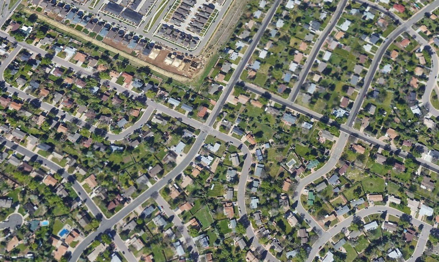
A 2017 aerial view looking southwest depicted dense housing covering the site of Bar None Airport.
Jim Urdea reported in 2018, “A recent hunt for the 3 survey markers was unsuccessful.”
____________________________________________________
Flying C Ranch Airfield / Littleton Airport, Sedalia, CO
39.47, -104.994 (Southwest of Denver, CO)
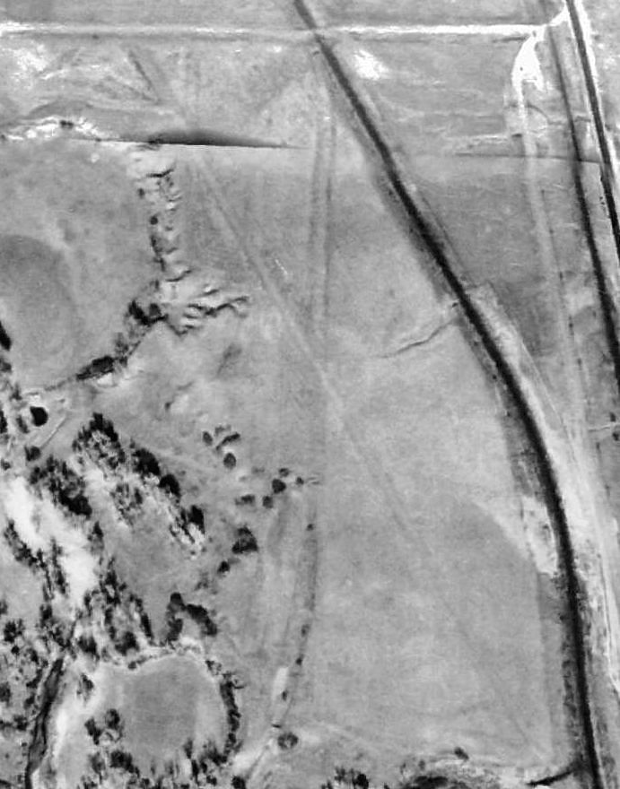
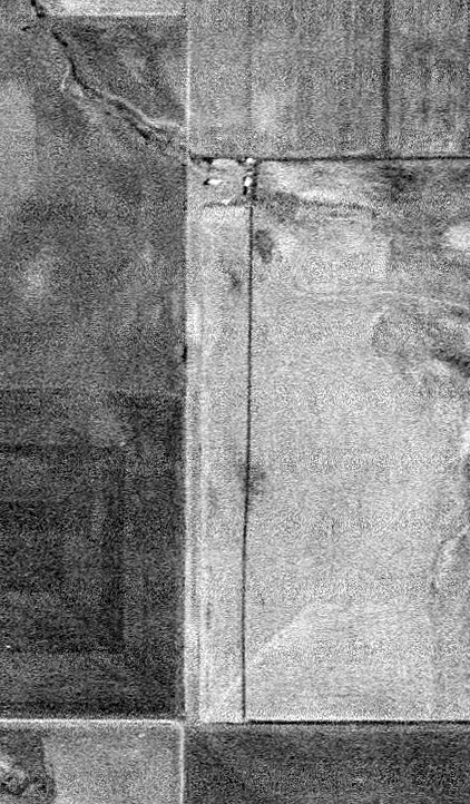
The Flying C Ranch Airfield, as depicted on a 1954 Douglas County aerial photo (enhanced by Bill Grasha).
This small general aviation airport was evidently established at some point between 1936-54,
as it was not yet depicted at all on a 1936 USGS aerial photo.
The earliest depiction which has been located of the Flying C Ranch Airfield was a 1954 Douglas County aerial photo.
It depicted the airfield as having 2 very rough unpaved runways.
There did not appear to be any buildings or aircraft at the field.
The Flying C Ranch was not yet depicted on the November 1961 Denver Sectional Chart (according to Chris Kennedy).
Cindy Baker reported, “My stepfather (Ed Clark - thus Flying 'C' Ranch) graded the runway on his own property in the 1960s.
He use to taxi his plane to the T-hangar next to the ranch house.”
The earliest aeronautical chart depiction which has been located of Flying C Ranch Airfield
was on the June 1963 Denver Sectional Chart (courtesy of Chris Kennedy).
It depicted the “Flying C Ranch” as a public-use airfield with a 2,600' unpaved runway.
The 1963 AOPA Airport Directory (according to Chris Kennedy) described the Flying C Ranch Airfield
as having a single 2,640' dirt Runway 13/31.
The earliest photo which has been located of the Littleton Airport was a 11/4/64 USGS aerial view (enhanced by Bill Grasha).
It depicted 9 single-engine planes parked around a few small buildings on the northwest side of an unpaved northwest/southeast runway.
The field was evidently renamed Littleton Airport at some point between 1963-65,
as that is how it was listed in the 1965 Jeppesen Airway Manual (according to Chris Kennedy).
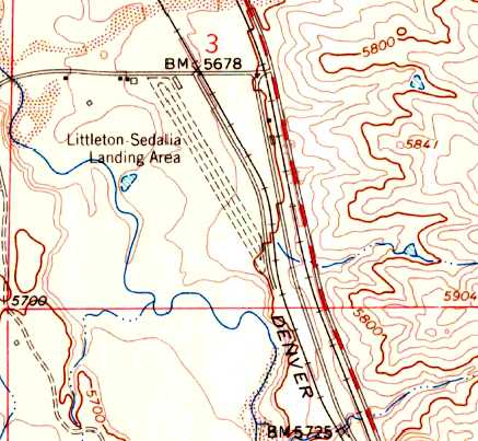
The earliest topo map depiction which has been located of the Littleton Airport was on the 1965 USGS topo map.
It depicted the “Littleton-Sedalia Landing Area” as having an unpaved northwest/southeast runway with a parallel taxiway & a few small buildings on the north side.
The 1970 Denver Sectional Chart (courtesy of Vince Granato)
depicted Littleton Airport as having a 2,800' unpaved runway.
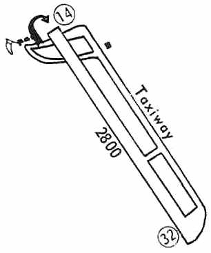
The 1972 Flight Guide (courtesy of Chris Kennedy).
depicted Littleton as having a single 2,800' unpaved runway, with a parallel taxiway on the east side,
and a few small buildings on the northwest & northeast side of the field.
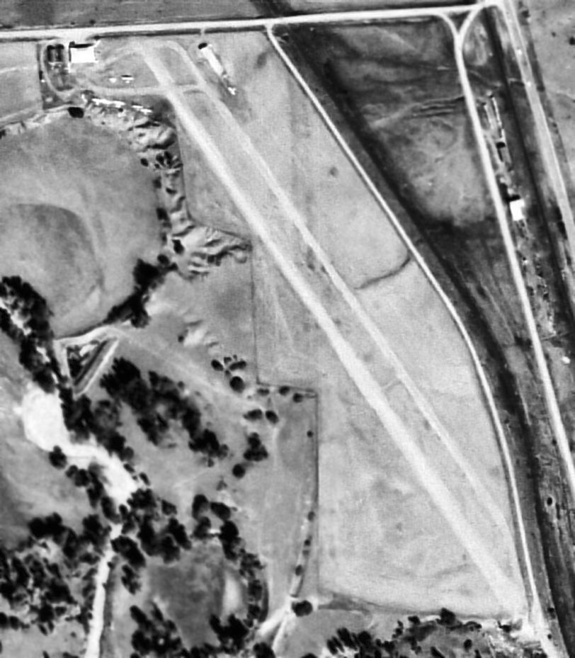
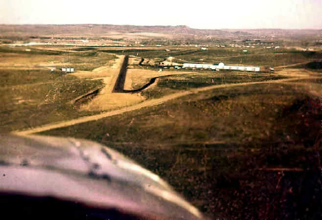
A circa 1970s aerial view looking east at the Littleton Airport (courtesy of Frank Niehus, enhanced by Bill Grasha).
It depicted the field as having a single unpaved north/south runway,
along with an office building northwest of the runway, a single long hangar to the northeast, and at least 23 planes visible parked outside.
The 1974 Denver Terminal Chart depicted Littleton Airport as having a 2,800' unpaved runway.
Cindy Baker reported, “My stepfather Ed Clark... owned the airport.”
Frank Niehus recalled, “Cindy Baker's father-in-law & his son Bob Clark sold Littleton Airport to my father-in-law, Mort Reynolds about mid-1974 or 1975.
I just checked my log books & that is when I started flying out of Littleton.
Mort sold it to a company from overseas & had to remove the hangars & structures then blacktop the existing runway.”
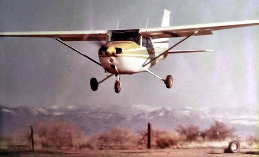
A
1975 photo by Chuck Starck (enhanced
by Bill Grasha) of a
Cessna 172 landing at "Clark/Littleton" Airport.
Chuck Starck recalled, “At that elevation, it was pretty short.
I asked my instructor when we were going to start short field landings, and he looked at me & said 'Where do you intend to land?'
His instructions were 'Clear the tire & the fence & get down RIGHT NOW!'
This was my first solo landing (going south with the infamous 'V' tree in line with the runway) in the new 152.”
Frank Niehus recalled, “The 2 pine trees on the south end of Littleton Airport, split into a 'V'.
They were no problem with my Skylane but when you took off with a C-150 you had to side-step those trees because they were lined up with the runway.”
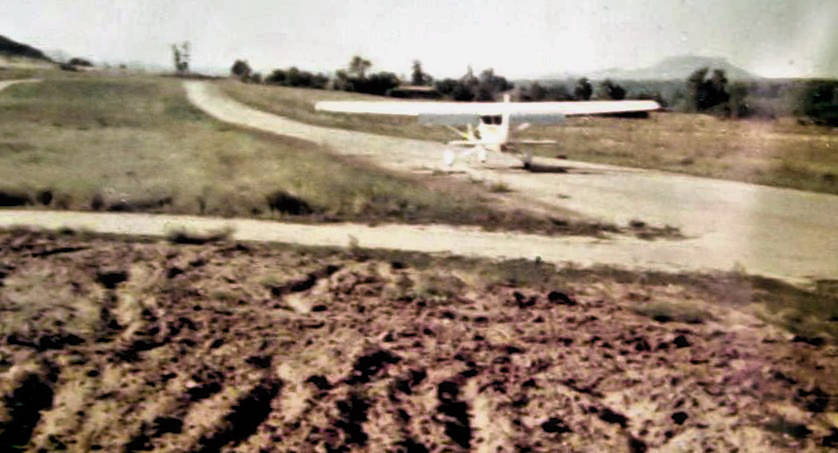
A 1975 photo by Chuck Starck (enhanced by Bill Grasha) looking north at Cessna 172 taxiing at "Clark/Littleton" Airport. Note the infamous 'V' tree in line with the runway.
Frank Niehus recalled, “My father-in-law owned Littleton Airport south of Louviers on Highway 85.
When Columbine Airport closed [circa 1975-76?] the parachute club moved down there
and they jumped down there until he sold it & it was developed into an industrial park.”
The 1976 AOPA Airports USA Directory (according to Chris Kennedy) described Littleton as having a single 2,800' gravel Runway 14/32.
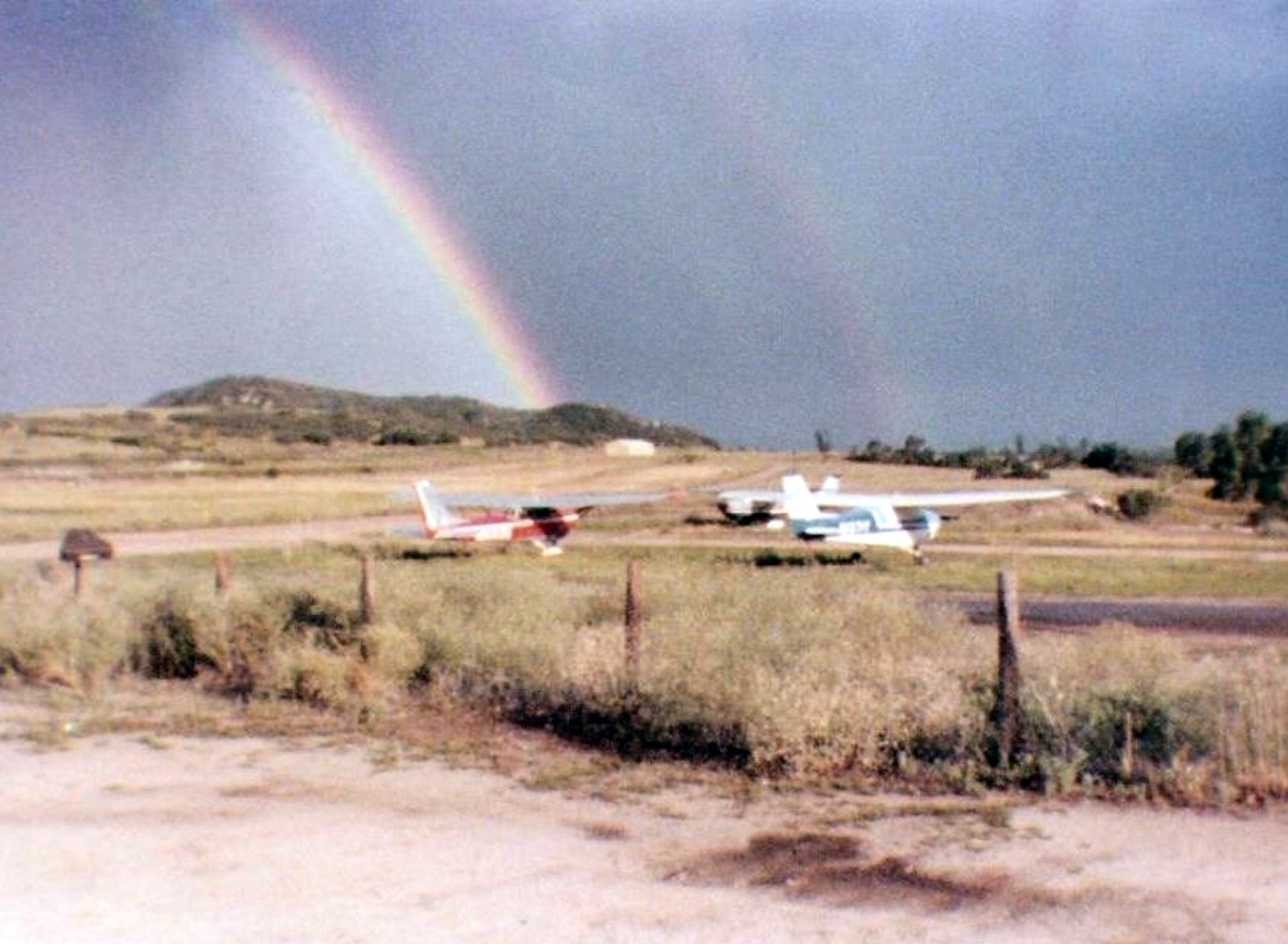
A circa 1970s photo a rainbow over 3 Cessnas at Littleton Airport.
The last depiction which has been located of Littleton Airport was on the February 1977 Denver Sectional Chart (courtesy of Chris Kennedy).
It described the field as having a 2,800' unpaved runway.
Littleton Airport was no longer depicted at all on the 1979 USGS topo map.
Frank Niehus recalled, “The last time per my log books I moved the airplane was 11/1981. So Mort Reynolds owned it from about 1975 -81.
They rented it for several years from Ed Clark before that. It was closed as an airport at the end of 1981.”
Littleton Airport was no longer depicted on the 1983 Denver Sectional Chart.
The 1994 USGS aerial photo showed that the Littleton Airport runway had been covered by a road, Reynolds Drive.
Not a trace appeared to remain of the former Littleton Airport.
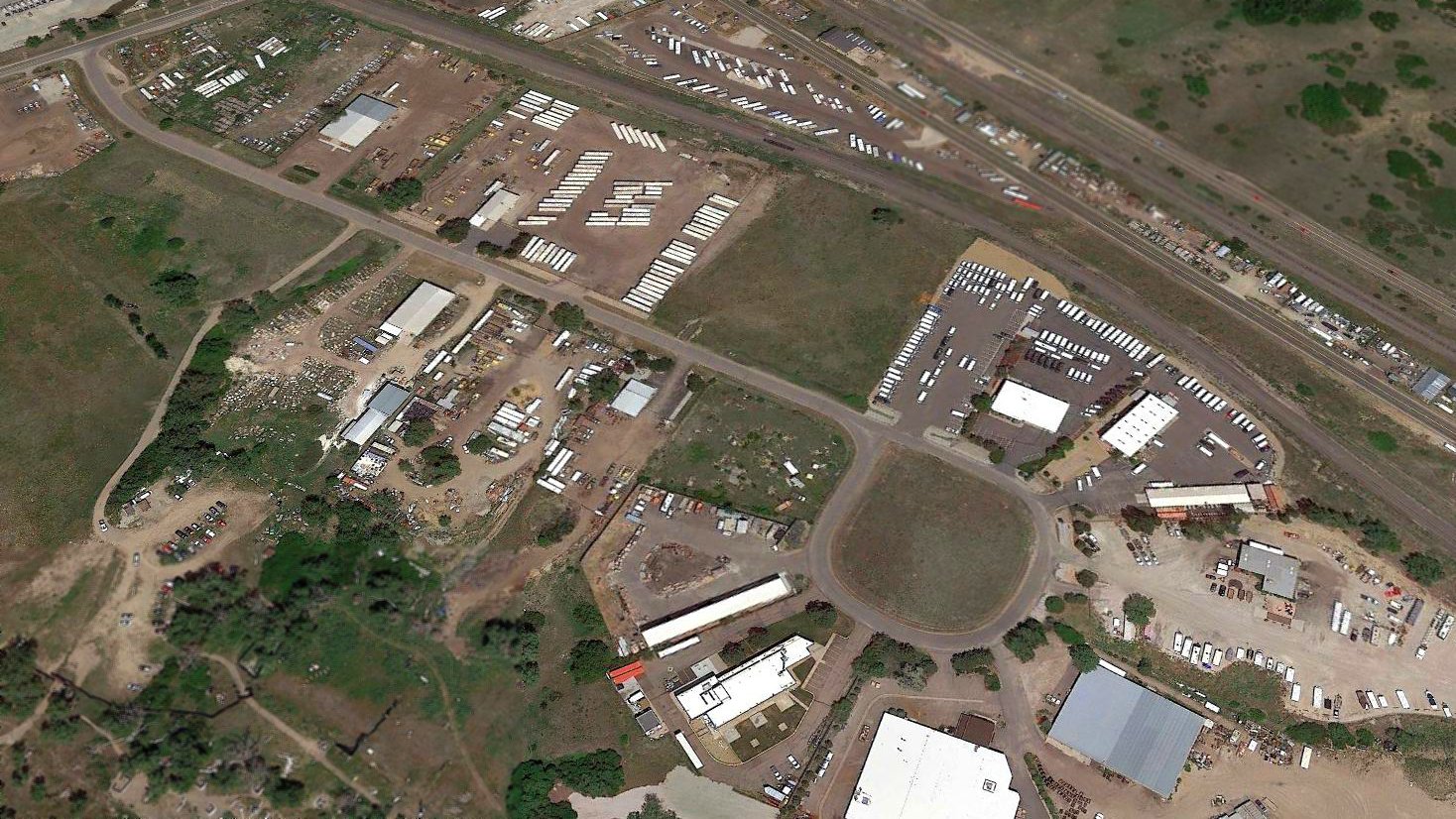
A 2017 aerial view looking northeast showed not a trace appears to remain of Littleton Airport.
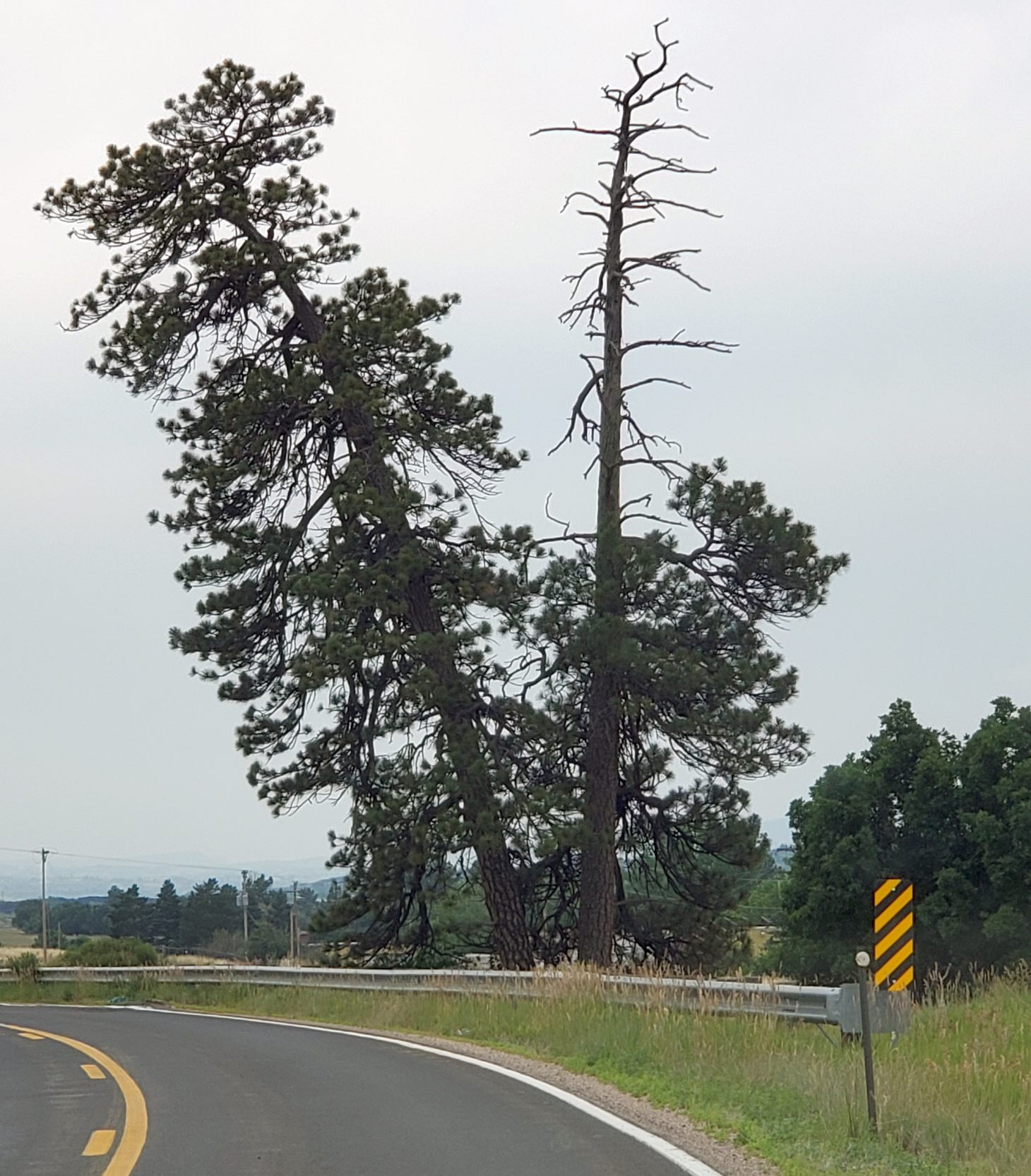
A 7/14/21 photo by Frank Niehus “of the 2 pine trees on the south end of the [site of] Littleton Airport. They are still there & one is dead but still standing.”
These same trees were visible in the 1975 picture several paragraphs above.
The site of Littleton Airport is located southwest of the intersection of Interstate 85 & West Airport Road, appropriately enough.
____________________________________________________
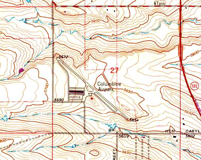
Columbine Airport, Littleton, CO
39.585, -105.105 (Southwest of Denver, CO)
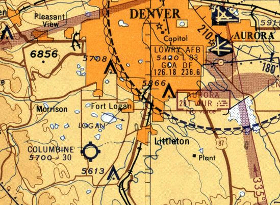
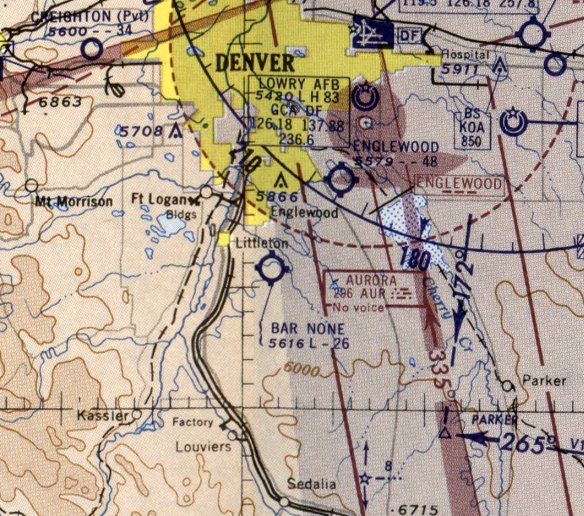
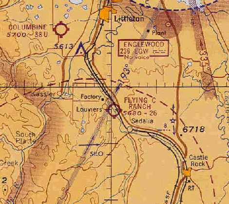
Columbine Airport, as depicted on the June 1960 Denver Sectional Chart.
This small general aviation airport was evidently established at some point between 1959-60,
as it was not yet depicted on a 1954 aerial photo nor on the May 1959 Denver Sectional Chart (according to Chris Kennedy).
MacAlan Thompson recalled of Columbine Airport, "Way back when, circa 1959-60,
I was at the Colorado School of Mines, and I joined their skydiving club.
We made a few jumps at this small airport. West of it a few miles there was a very sharp north/south ridge.
This would sometimes catch a good wind coming down off of the Front Range
and a Cessna could sort of hang over the burble at the top of the ridge & have no ground speed."
Note that there was also another field named Columbine Airport in nearby Aurora, on the east side of the Denver area, which must have caused some confusion.
The earliest depiction which has been located of Columbine Airport was on the June 1960 Denver Sectional Chart.
It depicted Columbine as having a 3,000' unpaved runway.
Steve Barnes recalled, "My Dad (who used to be a private pilot) took us kids to a couple of airshows there in the 1960s."
The 1962 AOPA Airport Directory described Columbine Airport as having a single 3,800' paved Runway 13/31.
The operators were listed as Thunderbird Flying System and D & J Flying Service.
The June 1963 Denver Sectional Chart (courtesy of Chris Kennedy) depicted Columbine Airport as having a 3,800' unpaved runway.
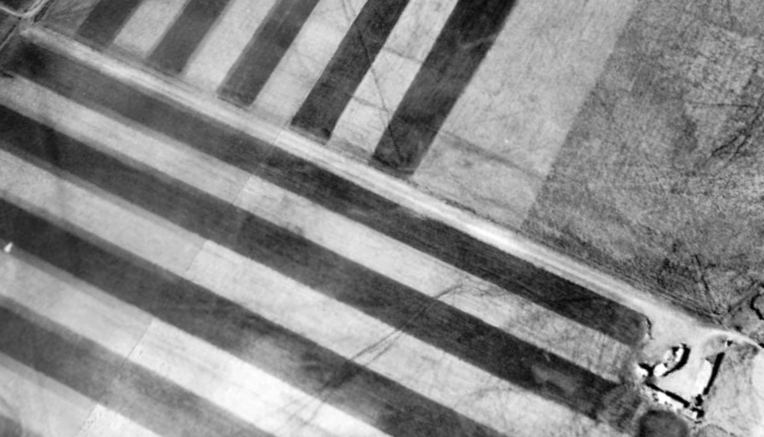
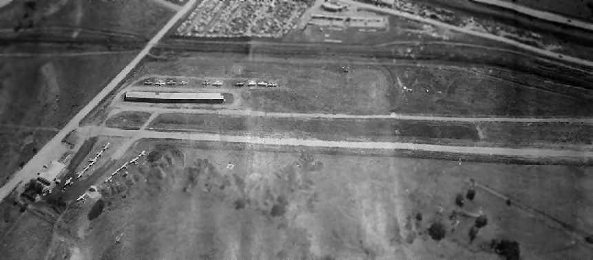
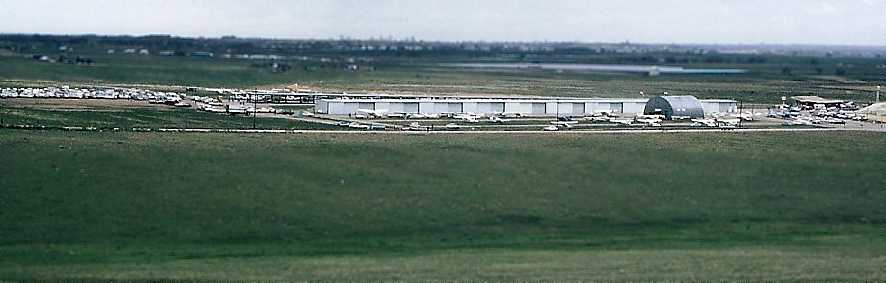
The earliest photo which has been located of Columbine Airport was a 5/13/63 USGS aerial view.
It depicted Columbine as having a northwest/southeast unpaved runway, with several dozen light aircraft & several hangars on the northwest side.
A 1964 aerial photo (courtesy of John French) showed Columbine's Runway 30 was extended to the northwest at some point between 1963-64.
John French reported, “It appears that the berm was constructed in order to keep the runway level
because the northwest extension would otherwise have resulted in the runway dipping down rather steeply to the north/northwest into the Dutch Creek Valley.”
John DeBrouwer recalled, “During the spring of 1966, I was 9 years old, and things couldn’t have been much better.
Most of that spring was spent riding my bike... off to the west I pedaled...
up to the top of the bluff, and sit down on a rock among the outcropping.
At my feet is a pole attached to a metal base, with 4 bolts anchored to the bedrock.
I look high up to the top, and gaze at the housing of the beacon. How cool! I lower my eyes to the horizon, and take it all in.
Down the hill in front of me is the taxiway, and of course, the beautiful asphalt strip of runway.
Slightly to the left is the FBO, Cole Aviation, Vaughn Cole, Piper Sales & Service.
Beyond that are the tiedowns, one row of hangars, and a Quonset hut that serves as the maintenance facility.
This airport, Columbine Airport, will be my new home away from home for several years.”
John continued, “Although this area is now a fully developed part of Littleton, back then the roads were still dirt, with little traffic,
so when I heard a car coming around the corner of Ken Caryl & Kipling, I looked over its way, and saw that it was my father!
I jumped on my bike & rode down the hill to see what was going on.
He got out of his little brown Corvair (what a car!), and asked me to show him around.
Boy, was I cool now! Showing MY dad around an airport!”
John continued, “After a while, he told me to go get us a pop, and he would be over talking to the mechanic.
When I returned and handed dad his pop, we started looking at a Mooney parked on the ramp.
As soon as I finished my pop, my dad & the mechanic started whispering.
Then my dad turned to me and said, so, are you ready to go on your first airplane ride?
ARE YOU KIDDING?”
John continued, “We took of to the west, with me in the right seat, and my dad in the back. How glorious!
It was crystal clear (as it usually is in Colorado) as we cruised along the Front Range,
turned & headed towards Denver for a while, and then back toward the airport.
The mechanic/pilot told me to hold on to the yolk while we flew, you know, to get the feel of it.
He must have had it trimmed off real good, for I was looking out the window when he told me to look up.
His hands were folded across his chest, and he said look! You’re flying the airplane! I couldn’t believe it!
Then he set up for landing, flew the pattern & touched down. I thought the takeoff was fun - landing was the best!”
John continued, “The next few years you couldn’t pry me away from that airport.
The days were spent picking up trash or helping fuel planes for some flight time with an instructor .
I promised myself that one day I would own a Piper Cherokee just like the one that the instructor took me up in.
I spent the weekends going up with Richard Rooney from Denver Sport Parachute Club,
and most evenings you could find me attending meetings or functions with the Littleton squadron of the CAP.
But it was soon to end, for progress (in the form of Ken Caryl Ranch) was about to leave its mark.”
Columbine Airport evidently gained a paved runway at some point between 1963-67,
as the December 1967 Denver Sectional Chart (courtesy of Chris Kennedy) depicted the field as having a single 4,000' paved runway.
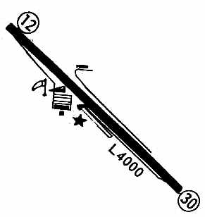
The 1967 Flight Guide (courtesy of Chris Kennedy) depicted Columbine Airport as having a single 4,000' paved Runway 12/30,
along with a few small buildings (hangars?) on either side of the middle of the runway.
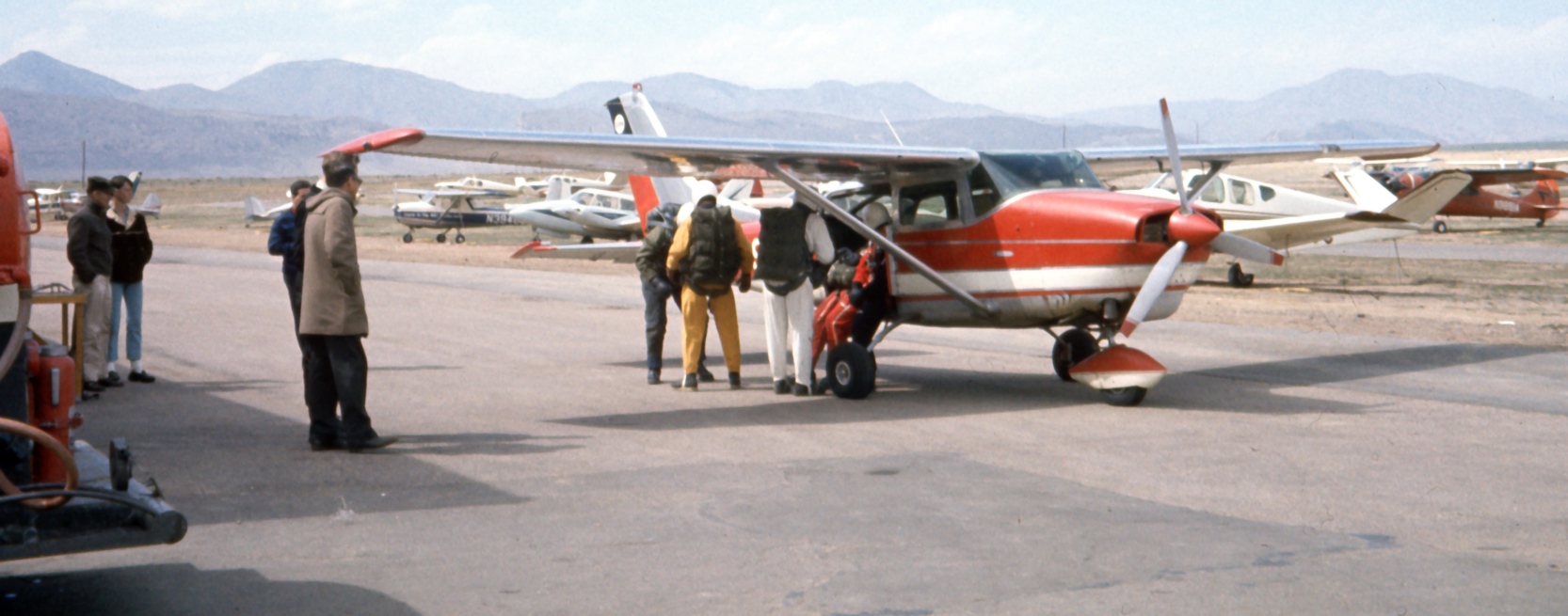
A 1967 photo by Ted Frison of skydivers boarding a Cessna 206 at Columbine Airport.
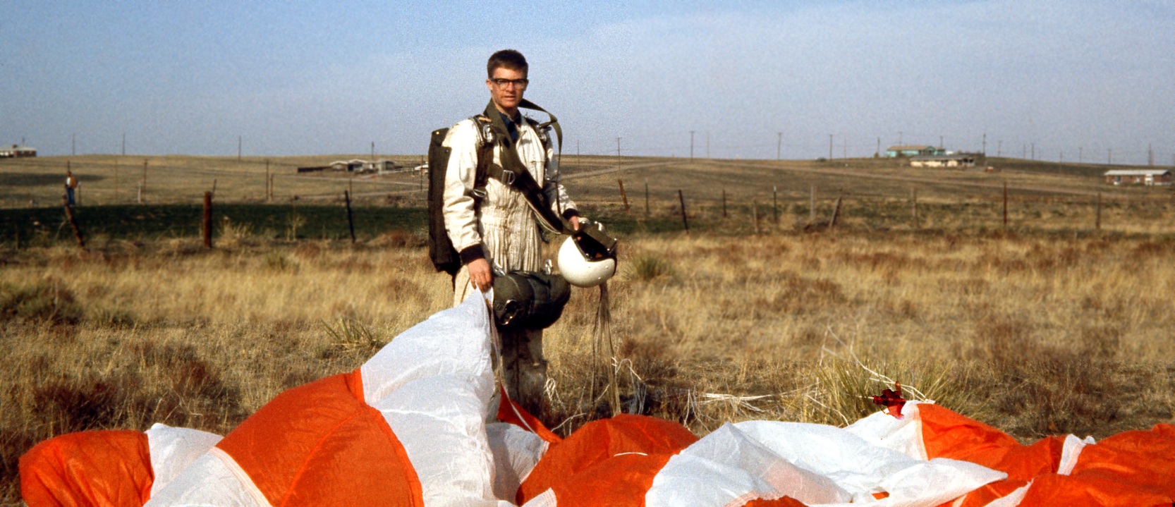
A 1967 photo of Ted Frison after a parachute landing at Columbine Airport.
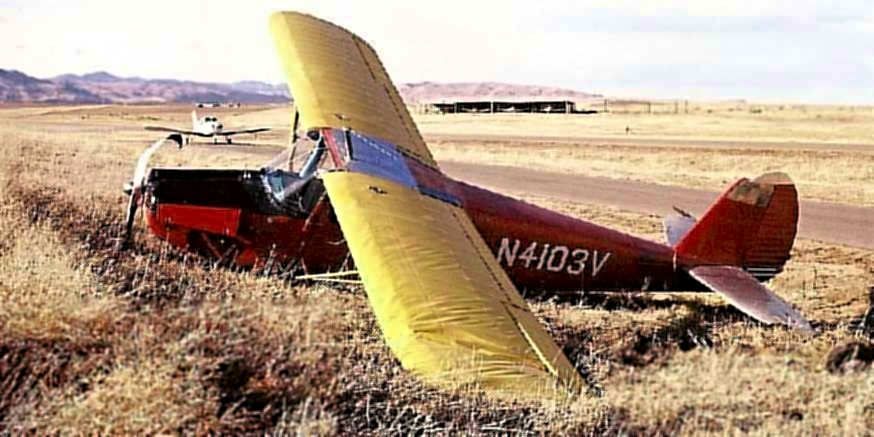
A February 1967 photo by Mike Wotovitch (enhanced by Bill Grasha) of Cessna which suffered an accident at Columbine Airport.
According to Ron Lewark, “The picture of the damaged 1948 Cessna 170 N4103V...
I co-owned that plane with 2 other pilots. I was riding right seat that day while one partner was flying.
He came in to land & dropped it in from 8' or so above the runway, we bounced back in to the air, close to 10', I thought he would add power & go-around,
he did but pulled the power back & the plane hit the runway hard & turned left, went through the ditch, and shed its left gear.
The only thing hurt was his pride & the 170 was totaled. Insurance paid us off & he never flew again. We were all newly minted pilots in 1966.”
According to Ron Lewark, “I went on to fly & own several other planes at Columbine: a Cessna 170 & a 180.
I also flew skydivers for several years there for the Denver Sport Parachute Club. I had many fun times at Columbine, 1966-71.”
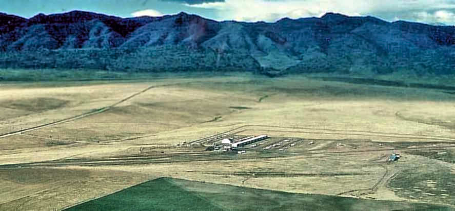
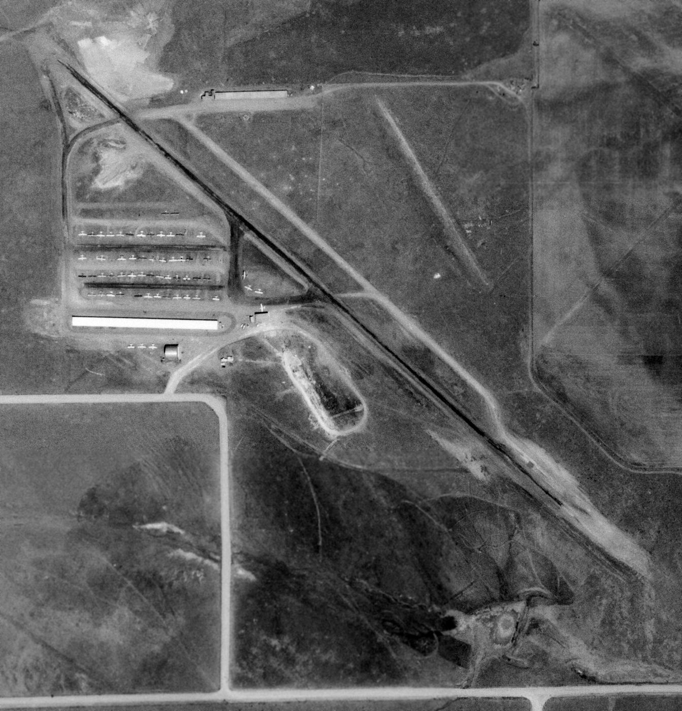
A circa 1960s-70s aerial view by Mike Wotovitch (enhanced by Bill Grasha) looking southwest at Columbine Airport.
A circa 1960s-70s photo by Mike Wotovitch of the hangars at Columbine Airport.
The 1971 Denver Sectional Chart depicted Columbine Airport as having a single 4,000' paved northwest/southeast runway,
and indicated that parachute drops were conducted at the field.
The 1971 USGS topo map depicted Columbine Airpark as having a single paved northwest/southeast runway,
with taxiways & a long hangar on the west side.
Alex Hauzer recalled, “I based an airplane at the Columbine Airport in the Denver area after relocating from IL in 1972.”
A 1973 aerial view of Columbine Airport, taken by Kim Barnes from a Cessna 172 on final approach to Runway 12 (enhanced by Bill Grasha).
Kim recalled, “That was the summer I was getting my Boy Scouts Aviation Merit Badge,
and Cliff Judson (the owner of the local FBO in Longmont) let me ride along to pick up some aircraft parts.
The heading is about 120 degrees looking right into Highlands Ranch off in the distance.
Of course, there's not a single house built in Highlands Ranch yet!
Those of you that know the area will recognize Kipling running from North/South
and that big hill going South towards Ken Caryl Boulevard.
You will also recognize the 'ledge' of the northwest end of the runway that is still there!”
John DeBrouwer recalled, “Although the airport principals tried to incorporate Columbine Airport
into the master plan of the area as a fly-in community, the density was just too high.
I don’t remember the exact date Columbine Airport closed, but it slowly became a ghost town,
and was gone in the early 1970s, another victim of the latest housing development.”
Alex Hauzer recalled of Columbine, “I really enjoyed flying out of this field but my joy was short lived as in early 1973 a local developer, Wood Brothers
purchased the airport & surrounding land for development of cookie cutter housing.
My last flight from the airport was on 6/29/1973. The field was officially closed 2 days later.”
According to Ron Lewark, “ I have a newspaper article showing the 200 acre airport was sold to Woods Brothers Homes for $673,000.
It said the airport would remain in operation for 18 months before they develop it into homes.
I wonder what that 200 acres would be worth in 2018? One very large fortune.”
According to John DeBrouwer, “Vaughn Cole of Cole Aviation carried the airport name from Littleton to Aurora”,
where the former East Colfax Airport was renamed Columbine Airport.
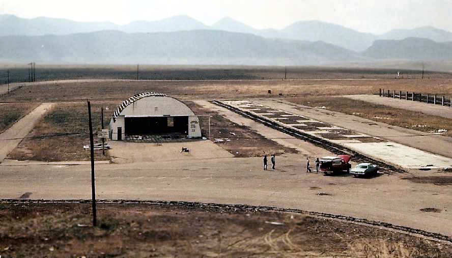
A circa 1970s photo taken by Mike Wotovitch “from the rockpile” (enhanced by Bill Grasha), looking toward Columbine's hangar after the closure of the airport,
with the foundations of the T-hangars visible after their removal.
The remaining hangar was painted with “Keep out this means you” to the right of the door - what a change from the days of this little airport's operation.
Columbine Airport was depicted as an abandoned airfield on on the 1974 Denver Terminal Chart.
Steve Barnes recalled of the Littleton Columbine Airport, “I drove my car on the runway right after it closed
and Medima Homes was starting to build the housing development all around the field."
In spite of evidently being closed 2 years prior,
Columbine Airport was still depicted as an active airport on the 1975 Sky Prints IFR Chart (according to Timothy Aanerud).
Columbine Airport was no longer depicted on the 1976 USGS topo map.
Hap Burnham recalled, "The former Columbine Airport was plowed under some years ago to make room for homes.”
A 1993 USGS aerial photo showed that the Columbine Airport site had been covered by homes & a school,
with not a trace still recognizable of the former airport.
John DeBrouwer reported in 2005, “Every once in a while, when I feel the need, I will go back to all that is left of Columbine Airport,
the rock outcropping on that little bluff hidden behind some townhomes, those 4 holes in the bedrock, and wonder, what if?”
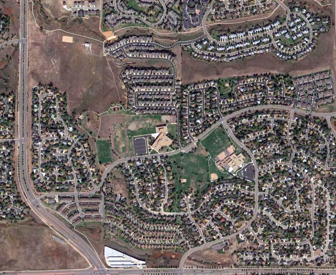
A 2015 aerial photo showed not a trace appears to remain of Columbine Airport.
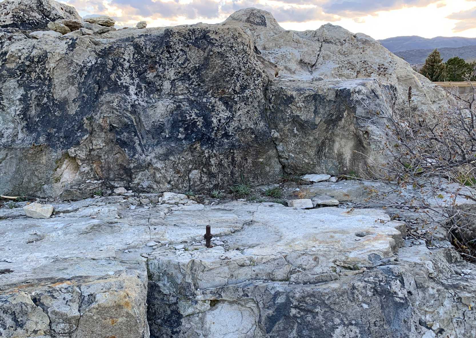
An April 2020 photo by Patrick Wolbach of the bolt & holes which remain in the rock from the former Columbine Airport beacon light tower.
Patrick reported, “I discovered there used to be an airport in the area where I grew up, Columbine Airport.
I even went to Deer Creek middle school from 2004-2005, the school that now sits where the airport used to be. I had no idea there used to be an airport there.
After reading what John DeBrouwer said (“Every once in a while I will go back to all that is left of Columbine Airport...”),
this inspired me to go check out the bolt holes that the airport beacon was once mounted to.
So I climbed to the top of the bluff that would've overlooked the airport & found the holes John was talking about. To this day there is still a bolt sticking out of the rock!”
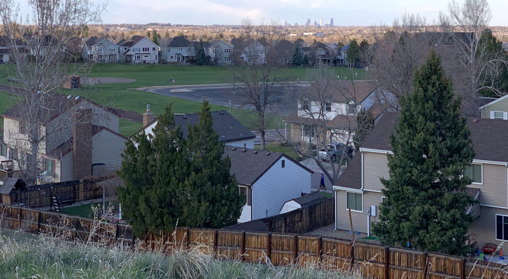
An April 2020 photo by Patrick Wolbach looking northeast at the site of Columbine Airport, with the Denver skyline visible in the distance.
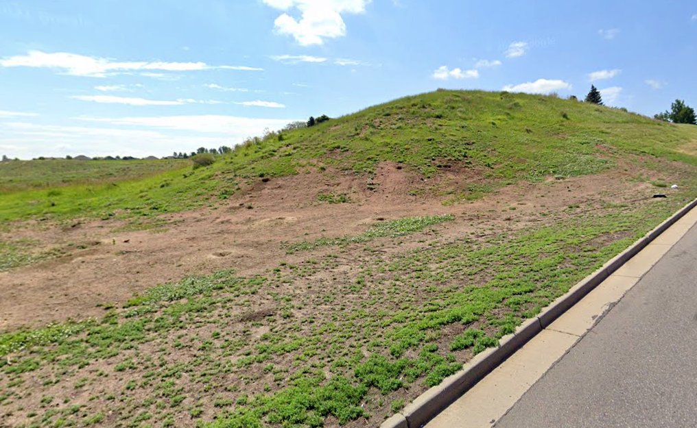
A July 2021 photo (courtesy of John French) looking southeast at a mound on the east side of South Kiplinkg Parkway which was constructed when Columbine Airport's Runway 30 was extended to the northwest.
John French reported, “It would be interesting to investigate that area on top of the berm to see if there are any remnants of the runway (bits of asphalt or whatever).”
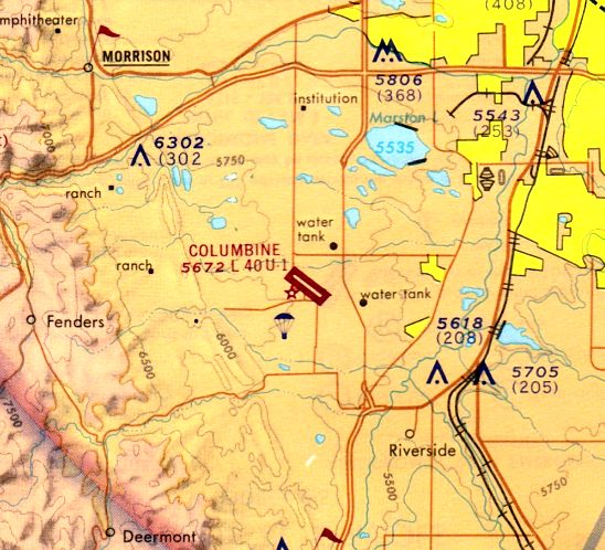
The site of Columbine Airport is located southeast of the intersection of Coal Mine Road & Kipling Road.
Thanks to Hap Burnham for pointing out this field.
____________________________________________________
Since this site was first put on the web in 1999, its popularity has grown tremendously.
If the total quantity of material on this site is to continue to grow,
it will require ever-increasing funding to pay its expenses.
Therefore, I request financial contributions from site visitors,
to help defray the increasing costs of the site
and ensure that it continues to be available & to grow.
What would you pay for a good aviation magazine, or a good aviation book?
Please consider a donation of an equivalent amount, at the least.
This site is not supported by commercial advertising –
it is purely supported by donations.
If you enjoy the site, and would like to make a financial contribution,
you
may use a credit card via
![]() :
:
Please consider checking the box to make a monthly donatation.
For a mailing address to send a check, please contact me at: paulandterryfreeman@gmail.com
If you enjoy this web site, please support it with a financial contribution.
please contact me at: paulandterryfreeman@gmail.com
If you enjoy this web site, please support it with a financial contribution.
____________________________________________________
This site covers airfields in all 50 states.