
Abandoned & Little-Known Airfields:
California - Southern San Diego area
© 2002, © 2023 by Paul Freeman. Revised 3/10/23.
This site covers airfields in all 50 states: Click here for the site's main menu.
For the 8th year, the CA pages of this website are sponsored by the California Pilots Association:
____________________________________________________
Please consider a financial contribution to support the continued growth & operation of this site.
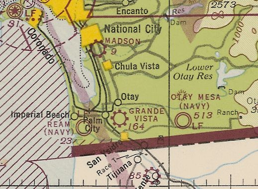
Border Air Service Field / Borderland Airport (revised 8/4/19) - Border NOLF / Border Field (revised 3/10/23) - Chula Vista Airport / Tyce's Airport (revised 3/10/23) - Grande Vista Airport (revised 9/4/20)
La Pressa Airport (revised 11/7/19) - Madson Airport / National City Airport (revised 5/14/20) - Peik Airport / Peik's Airport / Pikes Airport (revised 7/22/17)
Rosedale NOLF (revised 3/10/23) - San Diego Airpark (revised 12/16/19) - Sweetwater Dam NOLF / Sweetwater Airport (revised 7/18/21)
Wolfe Airpark (revised 11/7/19)
____________________________________________________
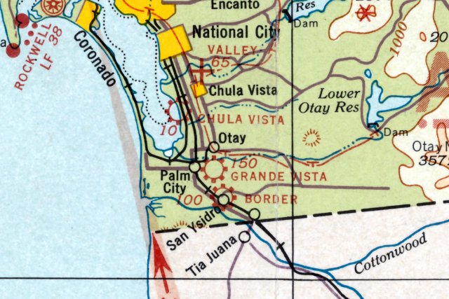
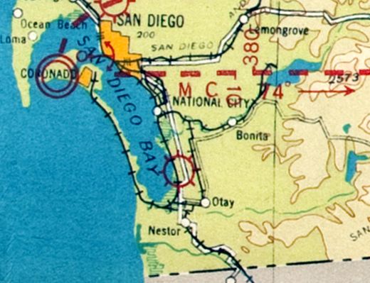
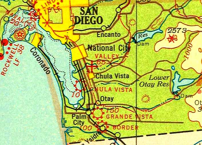
Border Air Service Field / Borderland Airport, Chula Vista, CA
32.571, -117.066 (South of San Diego, CA)
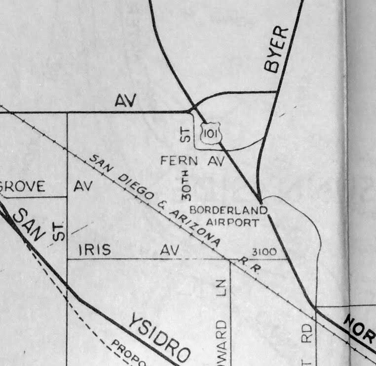
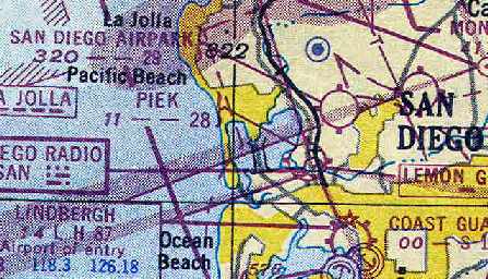
“Border” Airport, as depicted on the February 1934 San Diego Sectional Chart.
This early airport along the Mexican border was was not yet depicted on the 1928 San Diego - Tucson Air Navigation Map,
nor on the 1930 USGS topo map.
According to Curtis Carroll, “The earliest known date for the Border Air Service Field is 1931.
It was located on US 101. Ted Jacquot, brother of Robert (Grande Vista Airport), and Richard Hutton operated the 2,300' x 1,200’ irregularly-shaped field.
Mechanics did minor repairs in a 1-plane hangar. The convenience that made the field popular & profitable was taxi service to Tijuana.”
The earliest depiction which has been located of Border Airport was on the February 1934 San Diego Sectional Chart,
which depicted Border as a commercial/municipal airport.
Border Airport was presumably closed during WW2 (like most other small civilian airports near the coasts),
as it was not depicted on the 1943 USGS topo map
nor on the 1943 or 1945 San Diego Sectional Charts.
After the war, the field name changed to Borderland Airport & reopened with new owners Bob & Alice Foster & Ted Diver (according to the 11/2/45 Chula Vista Star, courtesy of Curtis Carroll).
An airport courtesy car took visiting pilots to the border or they could catch a bus every 15 minutes.
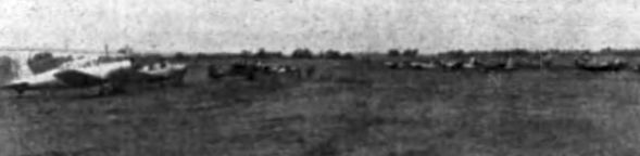
An undated photo courtesy of Curtis Carroll) of “Some of the 14 airplanes that landed at Borderland Airport 4/27/47 from Fullerton.
The early fliers arrives in time for breakfast at the Lazy-A Guest Ranch.”
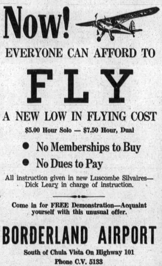
A 6/15/47 advertisement for Borderland Airport (courtesy of Curtis Carroll).
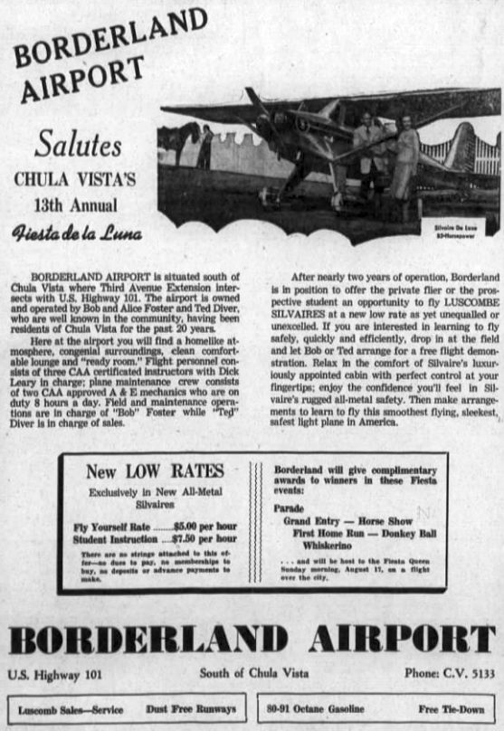
An 8/15/47 advertisement for Borderland Airport (courtesy of Curtis Carroll).
An August 1947 Flying Magazine listing (courtesy of Curtis Carroll) warned pilots not to stray into Mexican air space or face a $60 “customs fee”.
The listing mentioned a 1,900' northwest/southeast oiled runway & major overhaul facilities.
The last aeronautical chart depiction which has been located of Borderland Airport was on the December 1948 San Diego Sectional Chart.
It depicted Borderland as having a 1,800' unpaved runway.
Borderland Airport was no longer depicted on the 1950 USGS topo map.
According to Curtis Carroll, there was no mention of Borderland Airport in local newspapers after November 1950.
Borderland Airport was still depicted on a 1952 street map (courtesy of Curtis Carroll),
but it was presumably closed by that point.
Borderland Airport was no longer depicted on the March 1952 San Diego Sectional Chart.
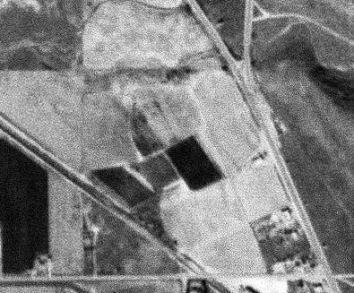
A 1/22/55 USGS aerial photo of the site of Borderland Airport appeared to show the property as having reverted to cultivation.
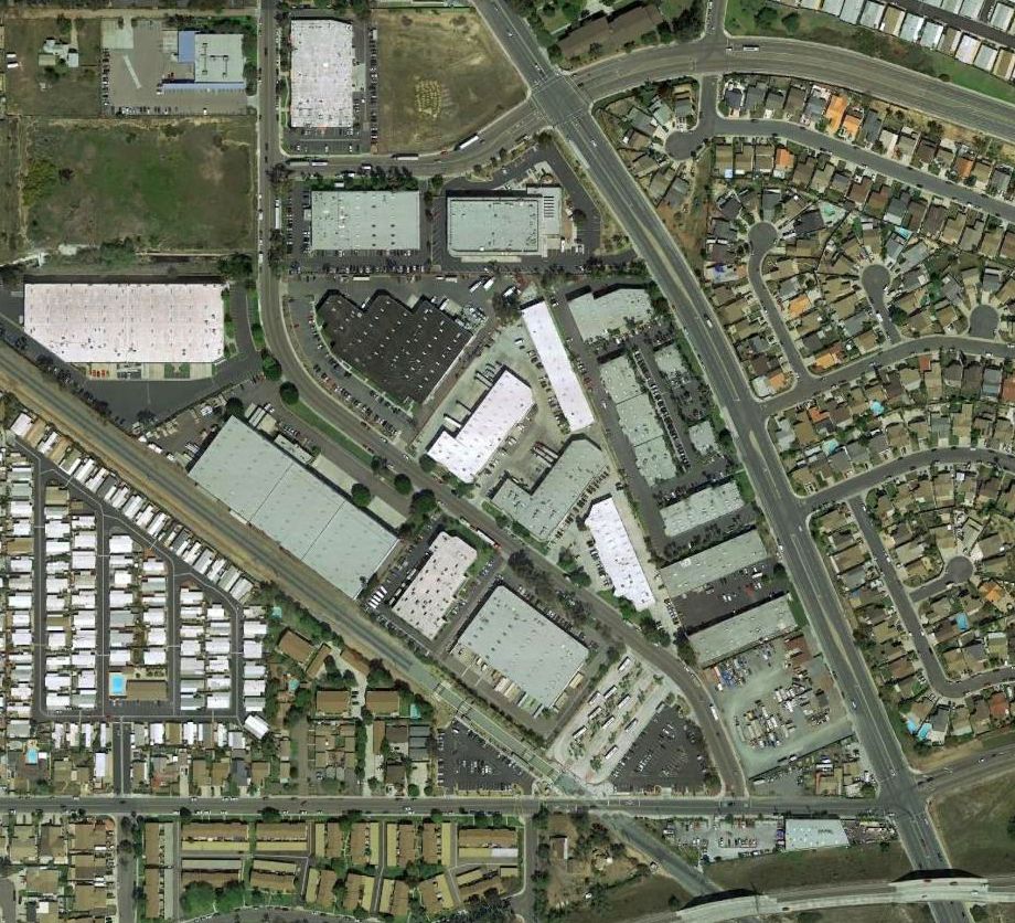
A 2016 aerial view showed no trace remaining of Borderland Airport.
The site of Borderland Airport is located northwest of the intersection of Beyer Boulevard & Iris Avenue.
Thanks to Curtis Carroll for pointing out this airfield,
and to Steve Schoenherr of the South Bay Historical Society for providing background information.
____________________________________________________
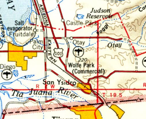
Grande Vista Airport, Palm City, CA
32.583, -117.068 (South of San Diego, CA)
Grande Vista Airport, as depicted on the February 1934 San Diego Sectional Chart.
This early airport was was not yet depicted on the 1928 San Diego - Tucson Air Navigation Map.
According to Curtis Carroll, “The Grande Vista Airport, sometimes called Palm City Airport,
was established in February 1930 by Robert Jacquot on land leased from & near the home of Hugh Rose.
By the end of that month he had opened a gliding club at his new airport.
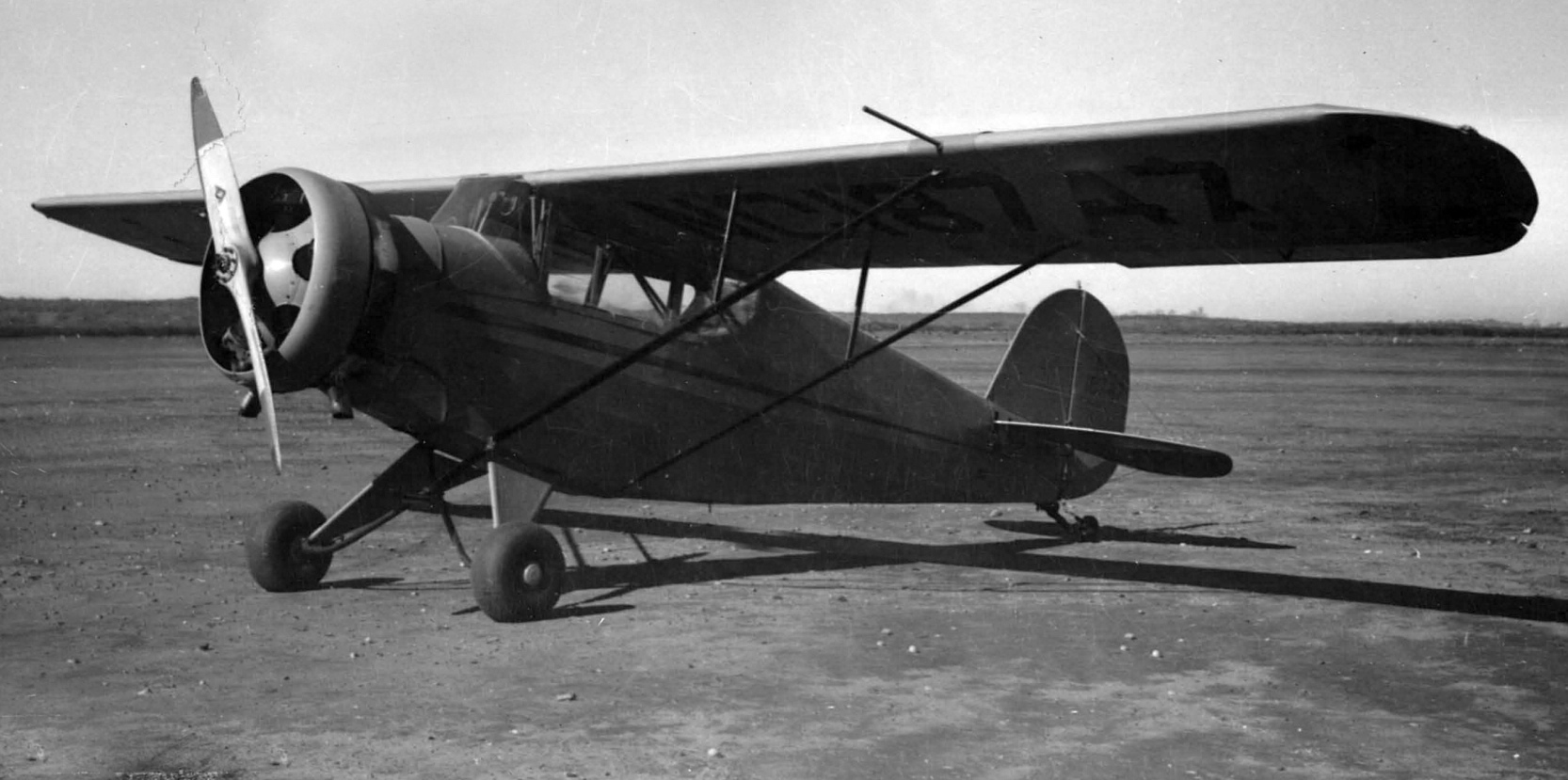
In early 1932, he bought a Fairchild 22 monoplane to train students & demonstrate it for sales under the business name 'Grande Vista School of Aviation'.
He also used the Fairchild to ferry single passengers to & from various locations in Baja California in the open cockpit plane.
In the mid-1930s he would carry multiple passengers in enclosed cabin aircraft; first a Ryan B-1 & later at least two different Wacos.
Between 1932-38, he would make some 150 paid trips to remote fields in the Mexican territory.”
The earliest depiction which has been located of Grande Vista Airport was on the February 1934 San Diego Sectional Chart,
which depicted Grande Vista as a commercial/municipal airport.
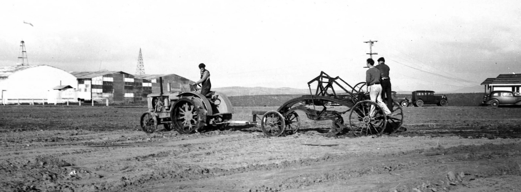
The earliest photo which has been located of Grande Vista Airport was a circa 1930s photo (courtesy of the San Diego Flying Club, via Mark Swanson)
of San Diego Flying Club members grading Grande Vista's runway, with 3 hangars visible in the background.
Grande Vista Airport, as depicted on the 1935 San Diego – Tucson Airway Chart.
According to Curtis Carroll, “The airport had ceased operations by early 1938 when the San Diego Flying Club took over the lease.
At that time, the airport had 3 short runways & 3 hangars to handle the club’s 2 Taylor Cubs & a Porterfield cabin monoplane.
The hangars had the field name on the roof & the club name on the outside walls.”
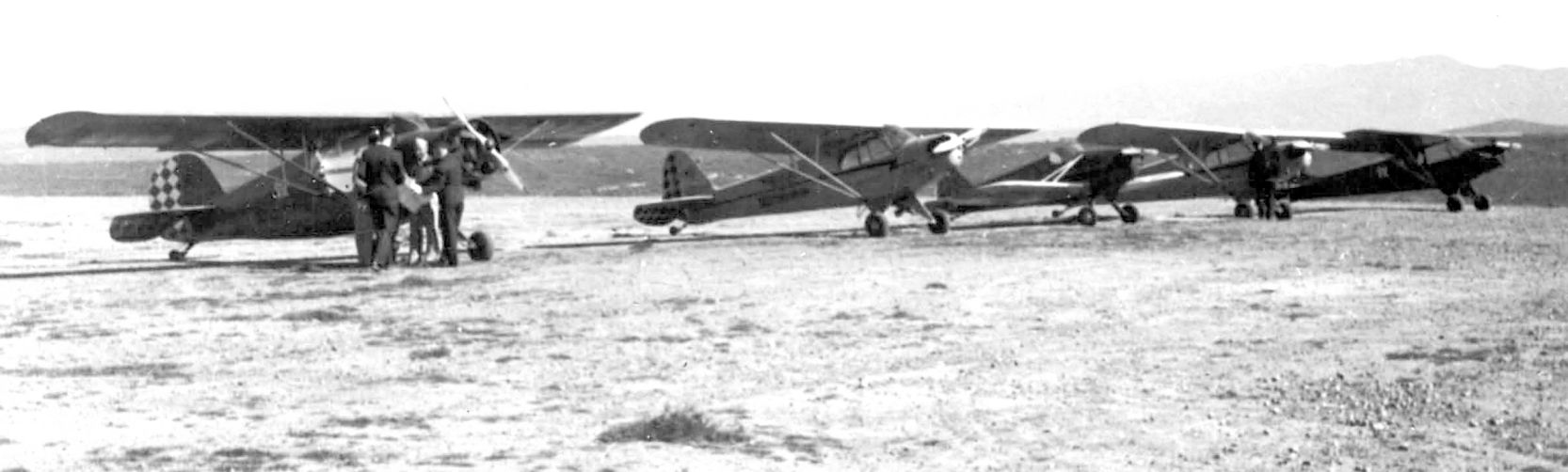
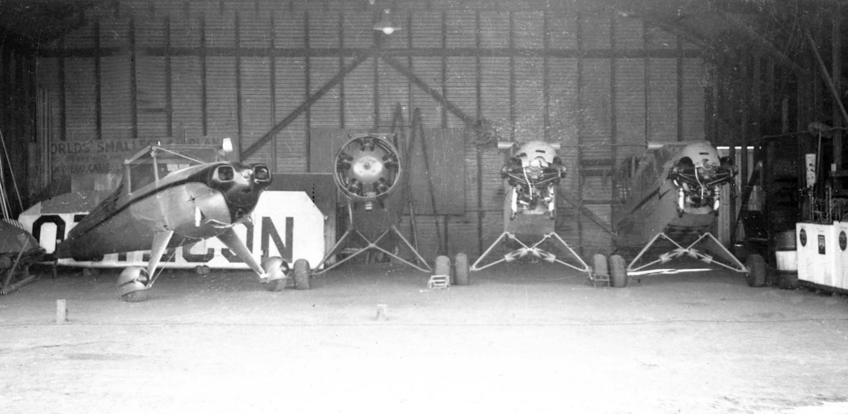
A circa 1938-41 photo (courtesy of the San Diego Flying Club, via Mark Swanson) of 5 light single-engine monoplanes (including NC32917) at Grande Vista Airport.
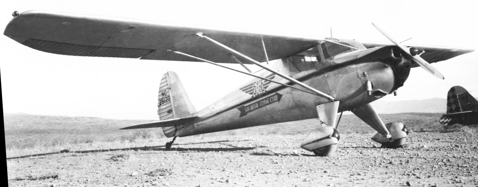
A circa 1938-41 photo (courtesy of the San Diego Flying Club, via Mark Swanson) of the San Diego Flying Club's Luscombe 8-A NC25020 at Grande Vista Airport.
A circa 1938-41 photo (courtesy of the San Diego Flying Club, via Mark Swanson) of Porterfield 35 NC18747 at Grande Vista Airport.
According to Curtis Carroll, “The flying club remained at Grande Vista until the government forced all civilian pilots to ground their airplanes in 1941.”
The last photo which has been located showing aircraft at Grande Vista Airport was a 1941 or later photo (courtesy of the San Diego Flying Club, via Mark Swanson)
of 3 San Diego Flying Club airplanes inside a Grande Vista Airport hangar, disassembled due to wartime restrictions on civilian aviation near the coasts.
The airplanes were Luscombe 8-A NC25020, Porterfield 35 NC18747, and 2 Piper Cubs.
The last aeronautical chart depiction which has been located of Grande Vista Airport was on the 1943 August San Diego Sectional Chart (courtesy of Ron Plante).
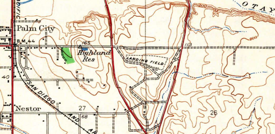
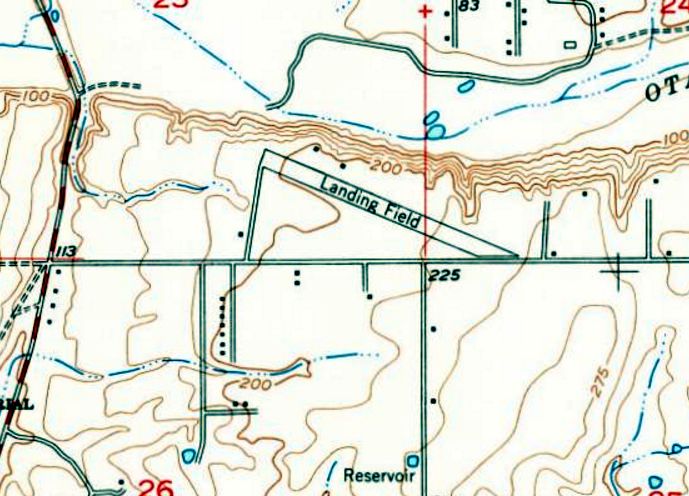
The only topo map depiction which has been located of Grande Vista Airport was on the 1943 USGS topo map.
It depicted a property outline oriented northwest/southeast, labeled simply as “Landing Field”.
There were no buildings depicted at the airport.
Grande Vista Airport was no longer depicted on the March 1944 San Diego Sectional Chart.
According to Curtis Carroll, “Shortly after WWII ended, Robert Jacquot intended to reopen his former airport when a tragedy occurred.
Jacques crashed & burned in an Vultee trainer shortly after takeoff from the field on 2/14/46.”
A 1953 aerial photo of the Grande Vista Airport site showed a rough northwest/southeast unpaved runway, with a small building on the southeast side.
There were no aircraft visible on the field.
A 1964 aerial photo of the Grande Vista Airport site showed the runway area having been taken over for agriculture.
The building at the southeast end of the Grande Vista Airport site remained intact in a 1968 aerial photo.
A 2016 aerial view showed no trace remaining of Grande Vista Airport.
The site of Grande Vista Airport is located southeast of the intersection of Palm Avenue & Beyer Boulevard.
Thanks to Curtis Carroll for pointing out this airfield.
____________________________________________________
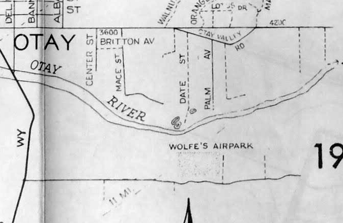
32.586, -117.052 (South of San Diego, CA)
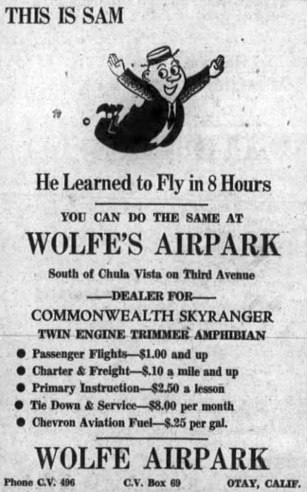
A circa 1946-47 advertisement for Wolfe Airpark from the Chula Vista Star (courtesy of Curtis Carroll).
According to Curtis Carroll, after Charles Wolfe left the Army Air Corps, “He settled in Chula Vista & opened the airpark.”
The opening of “Wolfe Airpark” was described in an 8/16/46 announcement (courtesy of Curtis Carroll),
and it was advertised in the Chula Vista Star (courtesy of Curtis Carroll).
Wolf's Airpark was not yet depicted on the August 1946 San Diego Sectional Chart.
The earliest aeronautical chart depiction which has been located of Wolf's Airpark was on the February 1947 San Diego Sectional Chart.
It depicted Wolf's as a commercial/municipal airport.
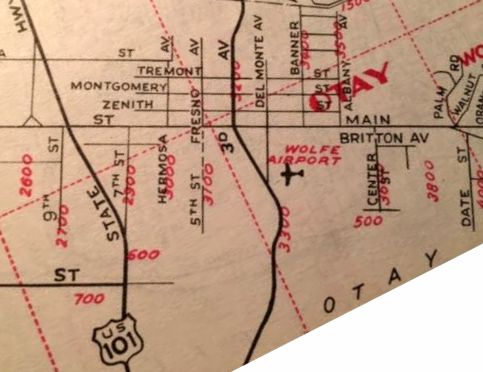
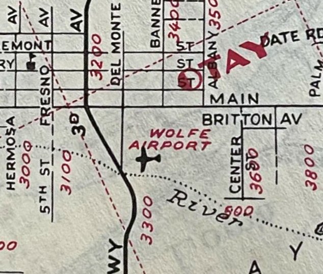
“Wolfe Airport” as depicted on a 1947 street map (courtesy of Curtis Carroll).
An entry in the July 1947 Flying Magazine (courtesy of Curtis Carroll)
described Wolfe Airpark as having a 3,000' dirt east/west runway,
with a crosswind runway oriented northeast/southwest “nearing completion”.
The March 1948 San Diego Sectional Chart (courtesy of Ron Plante) depicted Wolfes Airpark as having a 3,000' unpaved runway.
The only photo which has been located showing Wolfe Airpark was an undated aerial view looking north from the 1950 Air Photo Guide (courtesy of Kevin Walsh).
It depicted Wolfe Airpark as having an unpaved northwest/southeast runway.
The 1950 USGS topo map labeled the airport as “Wolfe Park (Commercial)”.
“Wolfe Airport” as depicted on a 1952 street map (courtesy of Curtis Carroll).
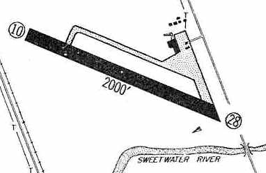
The last topo map depiction which has been located of Wolfe Airpark was on the 1953 USGS topo map.
It depicted a northwest/southeast runway, labeled simply as “Landing Field”.
Three small buildings were depicted on the west & north sides.
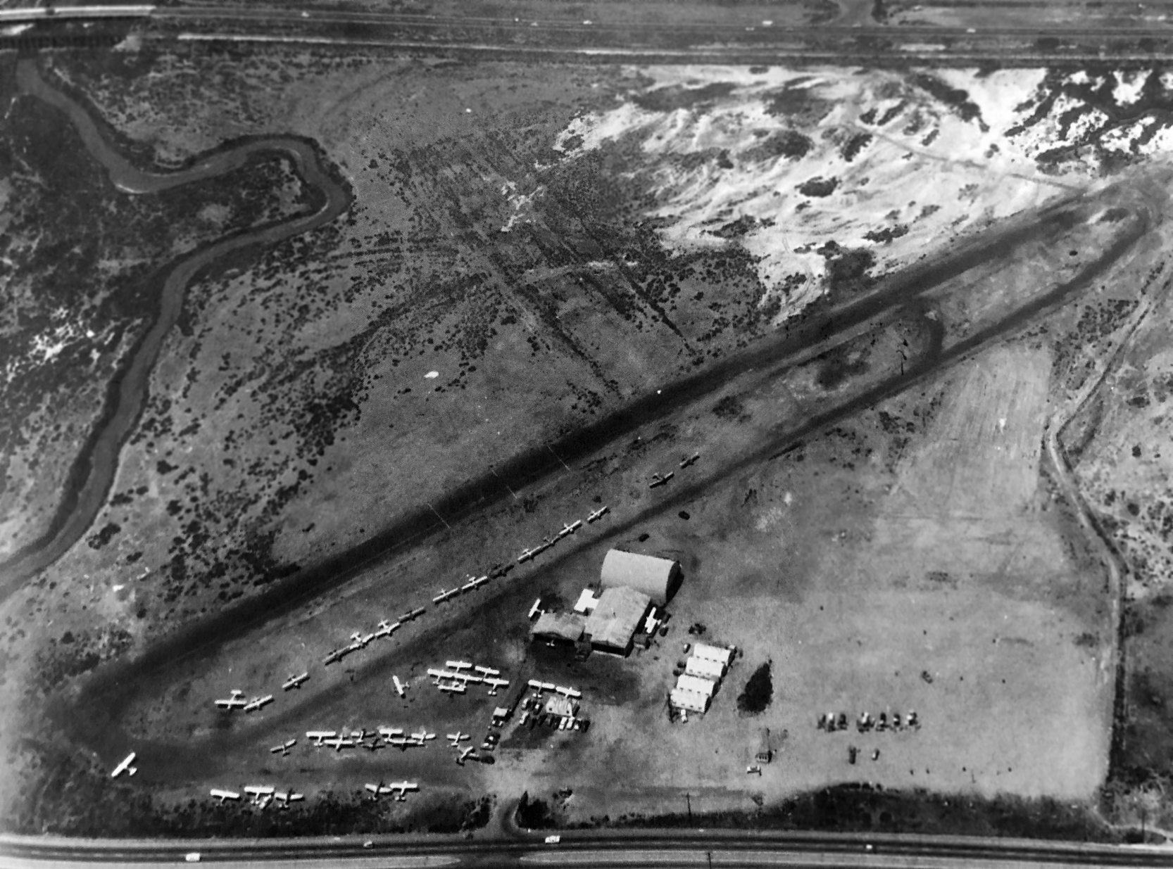
The only photo which has been located of Wolfe Airpark is a 1953 USGS aerial photo.
It depicted an unpaved northwest/southeast runway, with 2 small buildings on the north side,
and a total of 5 light single-engine aircraft parked on the north & south sides of the airport.
According to Curtis Carroll, “The small field operated as late as 1955.”
The last depiction which has been located of Wolfe Airpark was on the October 1956 San Diego Sectional Chart.
It depicted Wolfe as having a 2,900' unpaved runway.
Wolfe Airpark was evidently closed at some point between 1956-57,
as it was no longer depicted on the April 1957 San Diego Sectional Chart.
Wolfe Airport, as depicted on a 1957 street map (courtesy of Kevin Walsh).
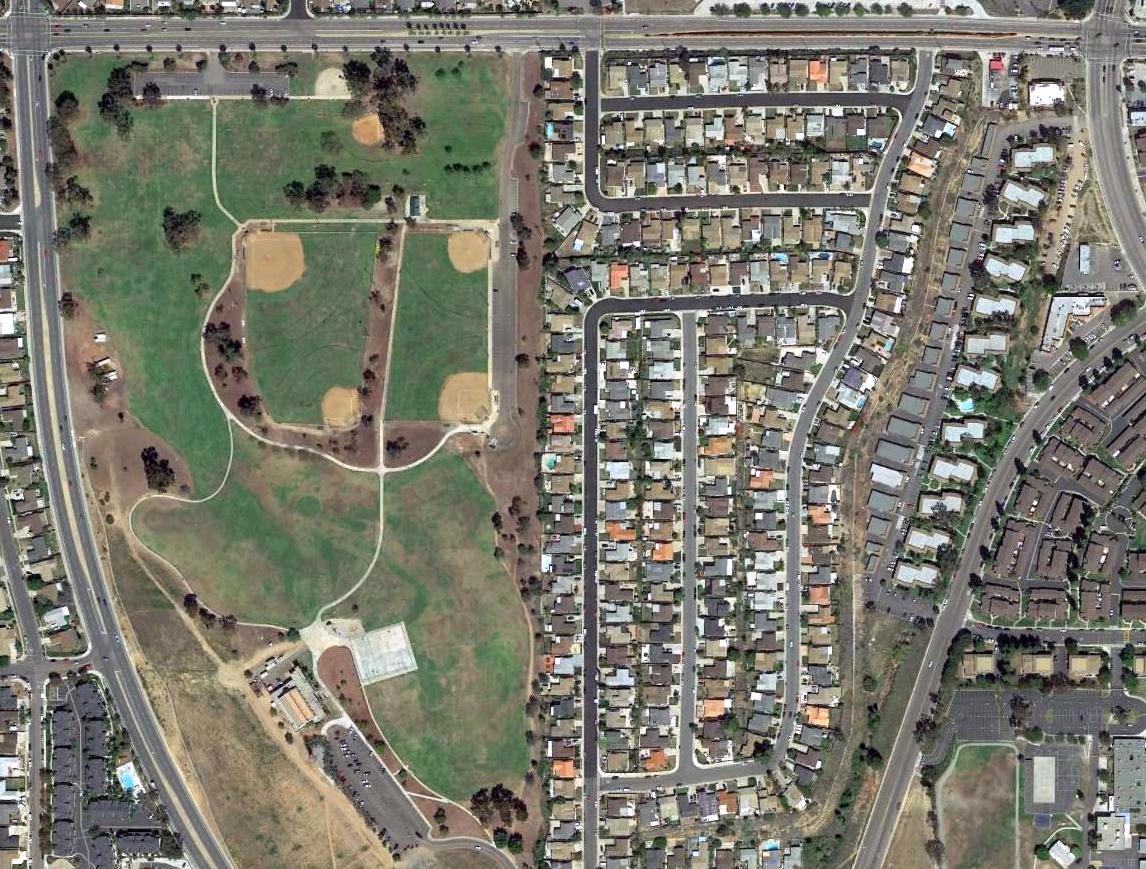
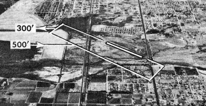
A 1964 aerial photo showed houses covering the western portion of the Wolfe Airpark site,
and Finney Elementary School covering the eastern portion, but the middle portion of the runway remained recognizable.
The middle portion of the Wolfe Airpark runway remained recognizable in a 1966 aerial photo.
A 1971 aerial photo showed a dense housing development having erased the last trace of Wolfe Airpark.
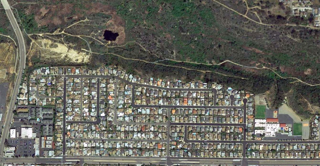
A 2016 aerial view showed no trace remaining of Wolfe Airpark.
The site of Wolfe Airpark is located north of the intersection of Palm Avenue & Cochran Avenue.
The property's aviation past is commemorated with the names of residential streets, such as Lindbergh Street, Doolittle Avenue, Le May Avenue, and others.
Thanks to Curtis Carroll for pointing out this airfield.
____________________________________________________
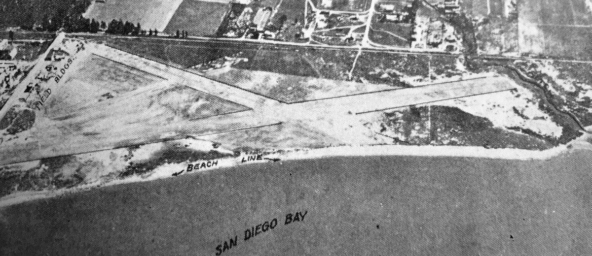
Chula Vista Airport / Tyce's Airport, Chula Vista, CA
32.633, -117.105 (South of San Diego, CA)
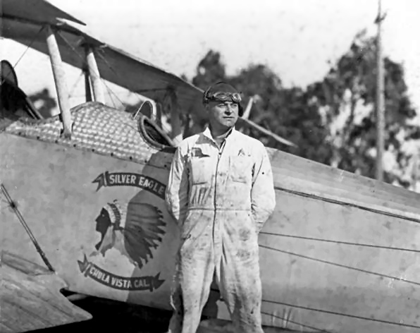
A 1926 photo of pilot Roland Tyce at the Tyce Flying School located at Chula Vista Airport.
According to Richard Scheid, Chula Vista Airport was established in 1921.
The earliest depiction which has been located of Chula Vista Airport
was a 1926 photo of pilot Roland Tyce at the Tyce Flying School located at Chula Vista Airport.
He was standing in front of a biplane (model undetermined) marked with “Silver Eagle, Chula Vista Cal.”
The earliest aeronautical chart which has been located which appears to show Chula Vista Airport was the 1928 LA-Tucson Air Navigation Map,
which depicted an unlabeled airport symbols roughly at the location of Chula Vista.
An undated aerial view looking east at Chula Vista Municipal Airport” from the Richfield Oil Company's 1930 California Airports directory (courtesy of Kathy Vaughn).
The directory described Chula Vista as having a 1,900' northwest/southeast runway & a 1,200' northeast/southwest runway, and listed the Manager as R. Tyce.
A 1930 aerial view looking northeast depicted Tyce's Airport as having a single unpaved northwest/southeast runway along the eastern shore of the bay,
with several hangars & buildings along the north end.
The only aeronautical chart depiction which has been located labeling Chula Vista Airport was on the 1934 Airway Chart.
It depicted Chula Vista as a commercial/municipal airport.
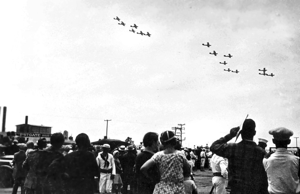
A circa 1930s photo of a crowd watching biplane formations overflying Tyce's Airport presumably during some kind of airshow.
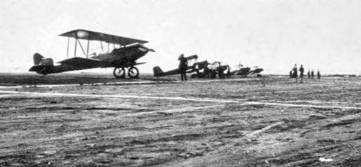
A circa 1930s photo of several unidentified biplanes at Tyce's Airport.
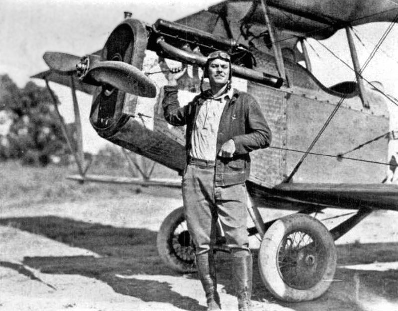
A circa 1930s photo of pilot Robert Tyce in front of a Jenny at Chula Vista Airport.
Robert & his brother Roland were both pilots & used the airport at the convenience of the railroad.
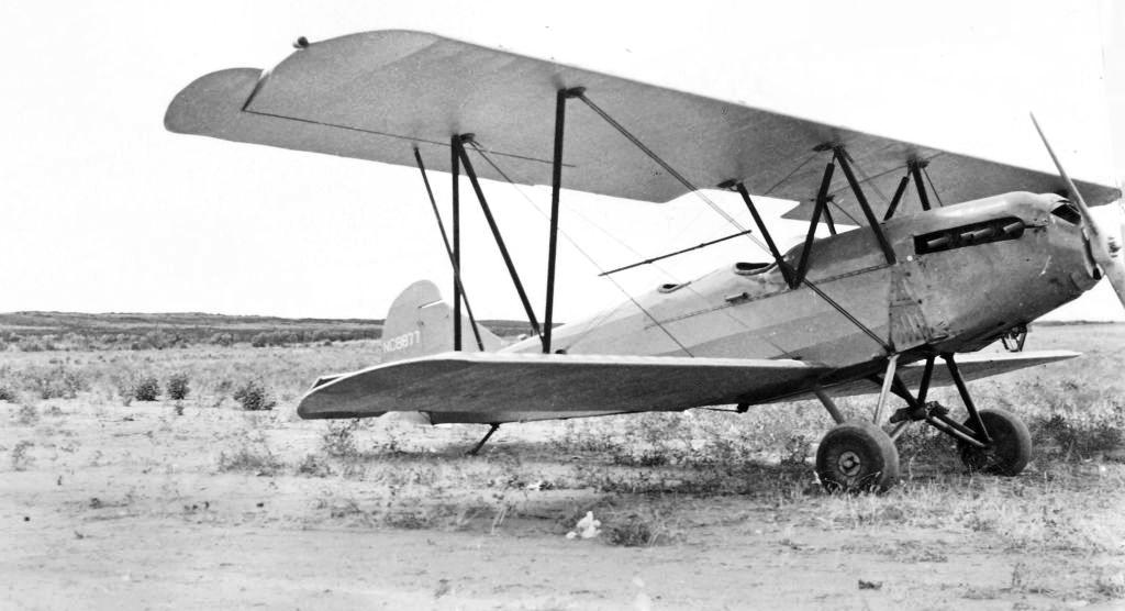
A circa 1930s photo of NC8877, a Travel Air 2000 serial #913 biplane at Tyce's Airport.

The last aeronautical chart depiction which has been located of Chula Vista Airport was on the August 1940 San Diego Sectional Chart.
The end of this little airport was evidently spelled by the need for increased factory space for wartime production.
According to the City of Chula Vista, “On 11/5/40, the Chula Vista City Council held a special election
and approved a bond issue of $15,000 to purchase the bayfront site for Rohr Aircraft.
Construction began on the first factory, which was 37,500 square feet of space.
The company's board of directors worried whether the company would ever be able to fill that huge building.
But by January of 1941, it became evident that more room would be needed, and the company received an Emergency Plant Facilities Contract,
and made plans to build an additional factory & office building.
The new buildings were completed in June of 1941.”
A 1941 aerial view (courtesy of Richard Scheid) looking north depicted Tyce's Airport as having a single unpaved northwest/southeast runway,
with several hangars & buildings along the north end.
A 1941 aerial view looking northwest at Tyce's Airport.
A 1941 photo of “Gibbs Luscombe” at Tyce's Airport, with the Rohr Aircraft building in the background.
Tyce's Airport was no longer depicted on the December 1941 San Diego Sectional Chart or the 1944 USGS topo map.
An 11/12/12 aerial view showed no trace remaining of Tyce's Airport.
The site of Tyce's Airport is located west of the intersection of Lagoon Drive & Interstate 5.
Thanks to Richard Scheid for pointing out this airfield.
____________________________________________________
San Diego Airpark, San Diego, CA
32.804, -117.2 (North of Downtown San Diego, CA)
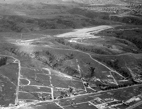
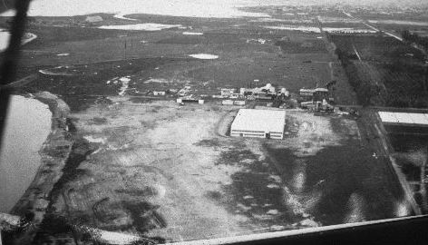
A 1947 Howard Rozelle aerial view looking east at San Diego Airpark (courtesy of John Fry).
This very short-lived general aviation airport was located just east of San Diego's Mission Bay.
San Diego Airpark was one of countless general aviation airports
which were established across America immediately after the end of the Second World War.
It was evidently opened at some point between 1946-47,
as did not appear to be depicted on a 1941 aerial picture (courtesy of Michael McAuliffe),
nor was it yet depicted on the 1943 USGS topo map nor on the February 1946 San Diego Sectional Chart (according to Chris Kennedy).
The earliest depiction which has been located of San Diego Airpark was a 1947 Howard Rozelle aerial view (courtesy of John Fry).
It depicted San Diego Airpark as having a dirt runway on top of a hill.
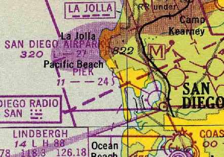
The earliest aeronautical chart depiction which has been located of San Diego Airpark was on the September 1948 San Diego Sectional Chart (courtesy of Chris Kennedy).
It depicted "San Diego Airpark" as having a 2,700' unpaved runway.
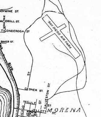
A 1948 street map (courtesy of Chris Kennedy) depicted "San Diego Airpark" as having 2 runways.

The 1950 USGS topo map depicted “San Diego” as a commercial airport.
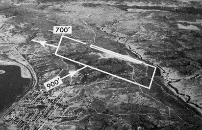
The last photo which has been located of San Diego Airpark was an undated aerial view looking north from the 1950 Air Photo Guide (courtesy of Kevin Walsh).
It depicted San Diego Airpark as having a 2,900' northwest/southeast dirt runway.
The field was said to feature an office & hangars, and the manager was listed as E.H. Sullivan.
The March 1951 San Diego USAF Sectional Chart (courtesy of Chris Kennedy)
depicted San Diego Airpark as having a 2,900' unpaved runway.
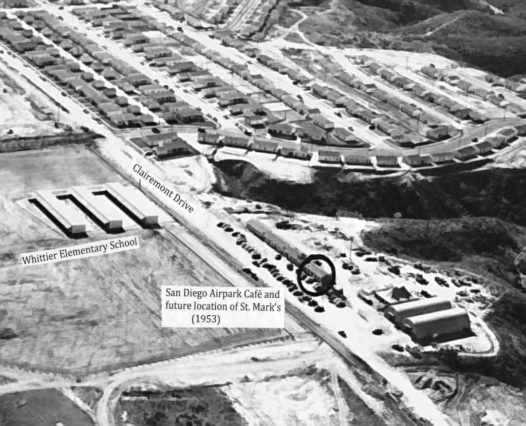
Curtis Carroll reported, “The airport was closed in 1951 & the land sold to Clair Burgener & Carlos Tavares; the length of airport structures; offices and café, remained.
These became the temporary headquarters of the Claremont Company & newly-chartered St. Mark’s Church.
The main runway of the Air Park was quickly paved & extended Clairemont Drive from the south.
In February 1953 the Methodist Conference bought 3 acres of land that included these buildings.”
The March 1953 USDA aerial photo (courtesy of Frank Moreland)
showed that the San Diego Airpark site had been graded & partially developed for housing.
An early 1953 aerial view looking southwest at the site of San Diego Airpark (courtesy of St. Mark’s Church Archives, via Curtis Carroll).
Curtis observed, the photo “shows the airport’s former offices & café and now the site of St. Mark’s Church.”
A 1953 Gousha San Diego Street Map (courtesy of Curtis Carroll) showed the site of San Diego Airpark covered with new residential streets.
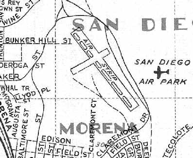
Curtis observed, “The 2,700' unpaved main runway was now Clairemont Drive between Iroquois & Rappahannock Avenues.
The crosswind runway was generally aligned with Dakota Drive.”
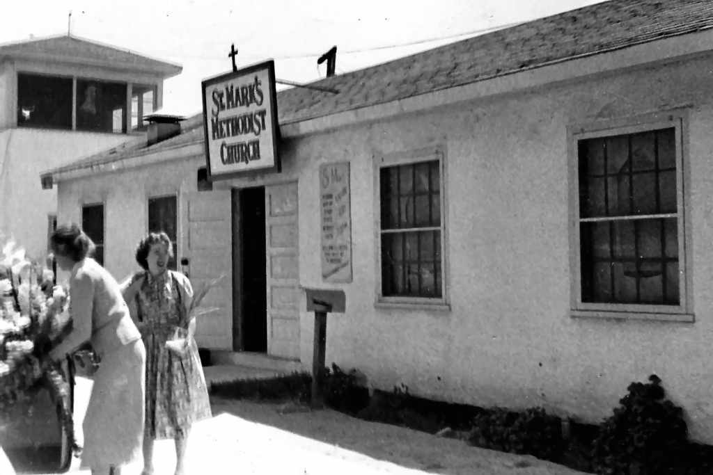
A December 1953 photo of the former San Diego Airpark cafe & tower (courtesy of St. Mark’s Church Archives, via Curtis Carroll), reused as the St. Mark’s Church.
Curtis Carroll reported, “The first worship was held in the former café in December 1953.”
By the time of the September 1954 San Diego Sectional Chart (according to Chris Kennedy),
San Diego Airpark was no longer depicted at all.
A 1955 street map (courtesy of Chris Kennedy) continued to depict the "San Diego Air Park",
even though the airport had already been built over for 2 years.
It depicted the field as having 2 runways, with the northwest/southeast runway having a parallel taxiway on the west side.
A 1964 aerial photo showed the site of San Diego Airpark to have been densely redeveloped with housing,
with not a trace appearing to remain of the little airport.
As seen in a 2006 aerial view, the site of San Diego Airpark has been densely redeveloped with housing,
and not a trace appears to remain of the little airport.
The site of San Diego Airpark is located west of the present-day intersection of Clairemont Drive & Dakota Drive.
____________________________________________________
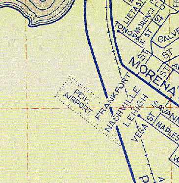
Peik Airport / Peik's Airport / Pikes Airport, Mission Bay, CA
32.765, -117.21 (Northwest of Downtown San Diego, CA)
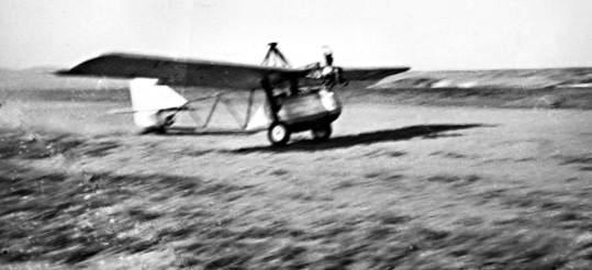
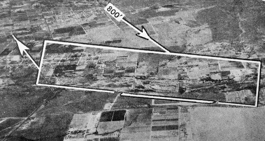
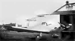
A 1937 photo of the “Flying Bathtub” homebuilt aircraft taking off or landing at Peiks Airport.
This little general aviation airport was located on the southwestern shore of San Diego's Mission Bay.
During its relatively short lifespan, the airport was listed under a somewhat confusing succession of somewhat different names.
According to an article entitled “Freeway Travelers Fly Past Peik’s Mission Bay Airport” by John McPeek in the 1/23/67 San Diego Evening Tribune (courtesy of John Fry),
“It all began when a young barnstorming pilot in a battered Stinson monoplane flew into San Diego a couple of weeks before Christmas of 1934.
His name was Arnold Peik. Trailing him on the ground was a mud-spattered 1928 Chevrolet sedan, driven by his wife, Lydia, and carrying their son, Leander, 7.
Behind the car rolled a homemade 13' house trailer, fashioned in part from old fuselage framing & airplane fabric.
The family made camp in an unused corner of Lindbergh Field while Peik took to the air to find a level site
where he could set up operations & offer flights to a public still fascinated by the sight of an airplane.
He found what he was looking for on the mud flats along the shore of Mission Bay.
The area, in the Southeast corner of the Bay near the mouth of the San Diego River, was undeveloped & littered with trash.
Peik cleared an 800' strip & on Christmas morning he & his family pulled the trailer to the flats & became squatters in the abandoned 2-room shack.
Peik's Airport was born.”
The earliest depiction which has been located of Peik's Airport was a 1937 photo of the “Flying Bathtub” homebuilt aircraft taking off or landing.
An 11/17/39 U.S. Navy aerial view looking southwest at Peik Airport (courtesy of Brian Rehwinkel)
depicted Peik as having a single northwest/southeast unpaved runway, with a few small buildings on the southwest side.
The earliest aeronautical chart depiction which has been located of Peik Airport
was on the December 1941 San Diego Sectional Chart (courtesy of Tim Kukas),
which depicted Peik as a commercial/municipal airport.
Peik Airport may have been closed at some point between 1939-41,
as it was not depicted on the June 1941 San Diego Sectional Chart (according to Chris Kennedy)
nor on the 1943 USGS topo map.
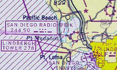
The August 1943 San Diego Sectional Chart (courtesy of Chris Kennedy) depicted "Peik" as a commercial airport,
and showed that "San Diego Radio" was located on the airport as well.
According to the San Diego Historical Society, Peik Airport was operated starting in 1943 by Arnold Peik.
The April 1944 US Army/Navy Directory of Airfields (courtesy of Ken Mercer)
described "Peik" Airport as having a 2,000' unpaved runway,
and indicated that Army flight operations were conducted from the field.
John Nance recalled, “In 1945 my father B. Plez Nance & his partner Leonard Copper
took over the lease from Arnold Peik & opened up a flight school called San Diego Flight Academy
and taught pilots how to fly on the GI Bill.
During that time they tore down some Army barracks that were in between the Peik's home & the flight operations office,
[and tore down the] maintenance hangar & built another hangar in it's place.
The new hangar was used to store the Aeronca Champs overnight.
He could get 4 in the hangar by tipping the Champs on their nose.
The flight school had about 4 Aeronca Champs, an Aeronca Sedan, a Cessna 140, a Taylorcraft and a couple of PT-22s.
There was a hangar & airport cafe on the north side for the field also.
My dad rented the north side hangar space out to aircraft owners.
It was a nice little airport & my dad made a nice living there
and I have a lot of nice memories & I enjoyed being a airport kid.”
The 1945 Haire Publishing Company Airport Directory (courtesy of Chris Kennedy)
described "Peik's Airport" as a "class 1" facility, "owned & operated by A. H. Peik".
It was said to have a single 2,400 oiled runway (oriented northwest/southeast) & an 80' x 46' hangar.
The field was described as offering storage, repairs, charter, and fuel.
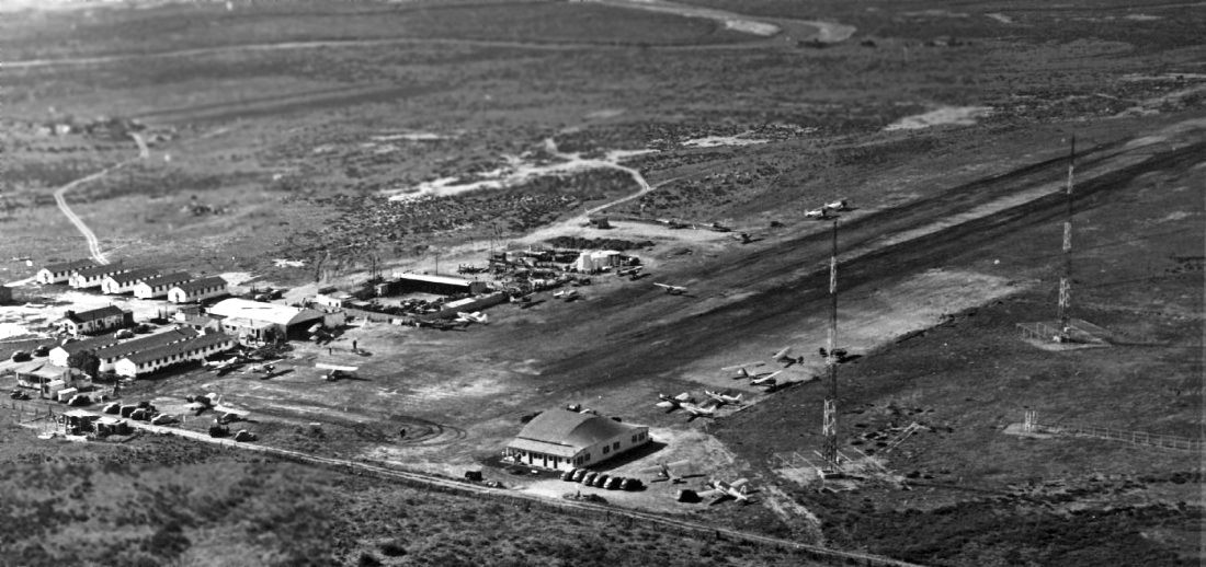
A 1946 aerial view looking west at Piek's Airport (courtesy of John Nance),
showing the former Army barracks on the left, the Pacific Highway Tecolote Canyon Bridge in the foreground,
and the the radio towers on the right.
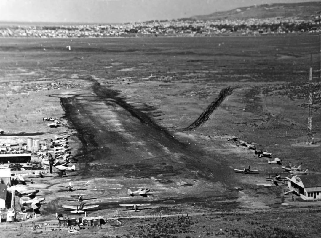
A 1946 aerial view looking northwest along final approach at Piek's Airport (courtesy of John Nance).
John observed, “The airport café is on the east side of the north side hangar [on the right].
The Piek home is the first structure on the south [left] side of the photo.”
Crown Point & Pacific Beach & Mt. Soladad are visible in the background.
According to the San Diego Historical Society,
by 1946 Peik Airport featured a 2,600' oiled runway & 3 hangars.
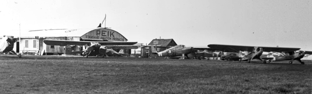
An undated (1940s?) photo of several Pipers & Aeroncas in front of the Peik hangar.
To further confuse matters, the September 1948 San Diego Sectional Chart (courtesy of Chris Kennedy) labeled the field with a different spelling: "Piek" Airport.
It was depicted as having a 2,400' unpaved runway.
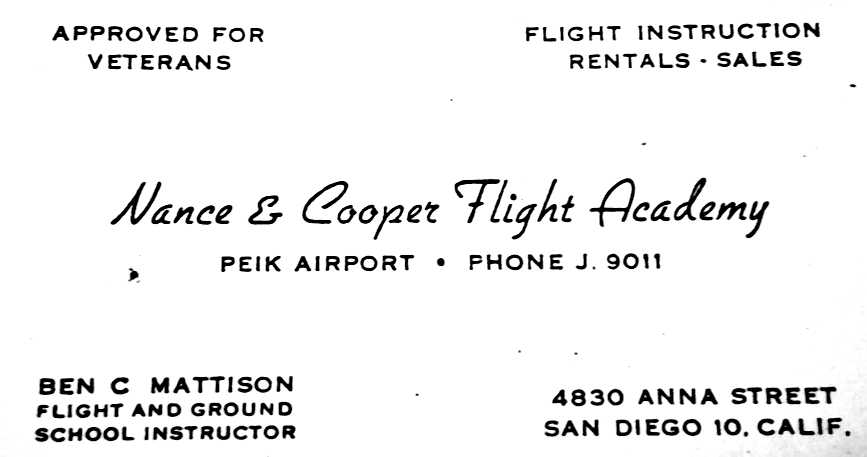
An undated business card for Peik Airport's Nance & Cooper Flight Academy (courtesy of Mike Oliver).
The 1950 USGS topo map depicted “Peik” as a commercial airport.
An undated aerial view looking north from the 1950 Air Photo Guide (courtesy of Kevin Walsh) depicted Peik Airport
as having a 2,800' oil surface Runway 12/30, and the manager was listed as B.P. Nance.
Dick Davy recalled, "I soloed from Pike's in about February 1951,
followed by a private certificate, commercial, multi-engine and single-engine seaplane I believe in 1955.
It was a great 'little' airport to train at.
You could get in 7 or 8 takeoffs & landings an hour when traffic was light.
The runway ran about 35 degrees west of paralleling US Highway 101,
and ended into rising terrain on the southeast end where the highway & a hill intersected."
The March 1951 San Diego USAF Sectional Chart (courtesy of Chris Kennedy)
continued to depict the field under the spelling of "Piek".
Mark Dossett reported, “The daughter of Arnold Peik (Peik's Airport) grew up in a house that was located at the field.
She had a lot of great stories about the field.”

A 1952 aerial view looking northwest along short final at Piek's Airport (courtesy of John Nance).
John observed, “You can see the front part of the hangar that my dad put up.
Crown Point is in the background & you can just see the Crown Point bridge that crosses over to what is now called Vacation Island.”
A 1952 photo taken just about at touchdown of Piek's Airport (courtesy of John Nance).
John observed, “You get a good view of the flight operations office.
The office window is right behind the 7UP machine & phone both.”
John Nance recalled, “My father [Plez Nance] & Mr. Copper operated the airport until about 1953.”
A 1953 aerial view depicted Piek's as having a single unpaved northwest/southeast runway,
with 20 light aircraft parked on the west & south sides.
The 1953 USGS topo map misspelled the name of the airport as “Pike Airport”.
It depicted the field as having an unpaved northwest/southeast runway, with a few small buildings on the east side.
A 1953 street map (courtesy of Kevin Walsh) depicted "Peik Airport" as a rectangular property outline.
Peik Airport was still depicted on the 1954 USGS topo map.
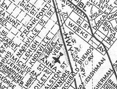
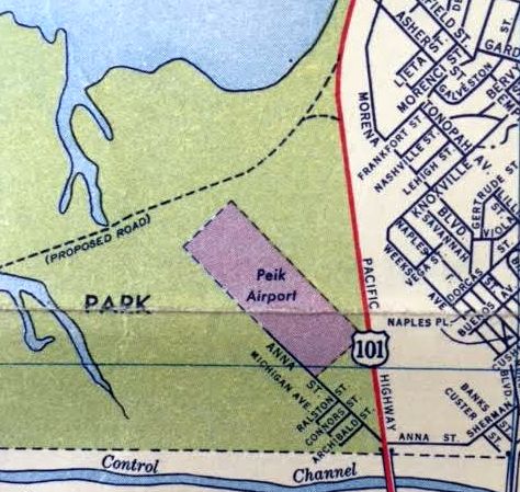
A 1955 street map (courtesy of Chris Kennedy) depicted "Peik Airport" within a very small plot of land,
bounded by Knoxville, Anna, Connors, and Pacific Highway.
This map was evidently erroneous, as the size of the airport's depicted boundaries do not seem to make sense,
being quite a bit smaller than would have been possible given the runway length listed for this field on multiple aeronautical charts.
This situation was explained by Johannes Long: “The streets on that map that are all dashed lines are all paper streets that did not exist then & [most] do not exist now.
Only Anna & a couple of others streets were actually built & used as access to the airport.
There are a number of old maps of San Diego with grid street patterns laid out across everything from deep canyons & steep slopes as well as mud flats such as Mission Bay.
The length of the runway was probably as long as the aerial charts say it was.”
The September 1955 San Diego Sectional Chart (courtesy of Chris Kennedy) depicted the field under another spelling: "Pikes" Airport.
The Aerodromes table described the field as having a single 2,600' bare runway.
The San Diego Radio facility was still depicted immediately adjacent to the southeast side of the airport.
A 1956 street map (courtesy of Chris Kennedy) depicted "Peik Airport" in a somewhat more northern location than the 1955 map,
but like the 1955 map it also seems to show the airport's boundaries as too small to have contained a runway of 2,000-2,600' in length.
According to the San Diego Historical Society, the City of San Diego bought ought Arnold Peik
and then closed the airport in 1957 in connection with the development of Mission Bay Park.
Peik Airport was no longer depicted at all on the September 1958 San Diego Sectional Chart (according to Chris Kennedy) nor on the 1958 USGS topo map.
By the time of a 1964 aerial photo, the site of Peik Airport had been wiped clean,
in preparation for the construction of parkland & roads which would eventually cover the site.
As seen in the June 2002 USGS aerial view, the site of Peik Airport has been covered by roads & parkland,
and not a trace appears to remain of the former little airport.
The site of Peik Airport is located roughly southwest of the present-day intersection of Interstate 5 & Sea World Drive.
____________________________________________________
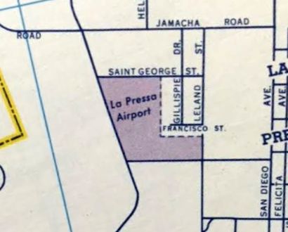
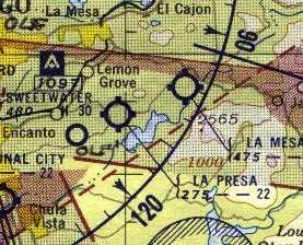
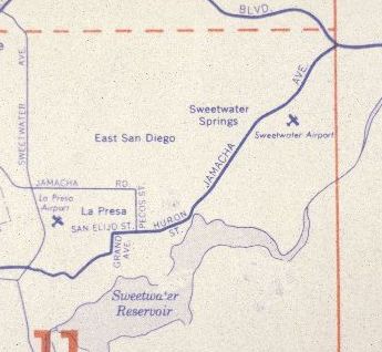
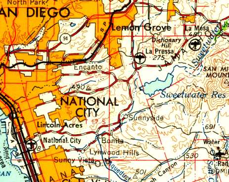
La Pressa Airport, La Pressa, CA
32.71, -117.01 (Southeast of Downtown San Diego, CA)
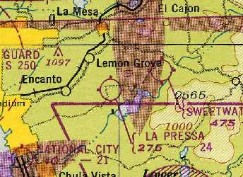
La Pressa Airport, as depicted on the 1945 San Diego Sectional Chart (courtesy of Chris Kennedy).
La Pressa Airport was evidently opened at some point between 1944-45,
as it was not yet depicted on the 1944 San Diego Sectional Chart (according to Chris Kennedy) nor the 1944 USGS topo map.
The earliest depiction of the field which has been located
was on the 1945 San Diego Sectional Chart (courtesy of Chris Kennedy).
It depicted La Pressa Airport as having a 2,400' unpaved runway.
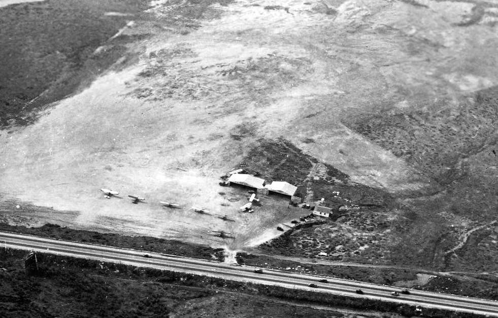
A 1945 photo of an Aircoupe at the La Pressa Airport.
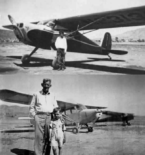
Tow 1947 photos of Bob Lyth in front of several airplanes at La Pressa Airport.
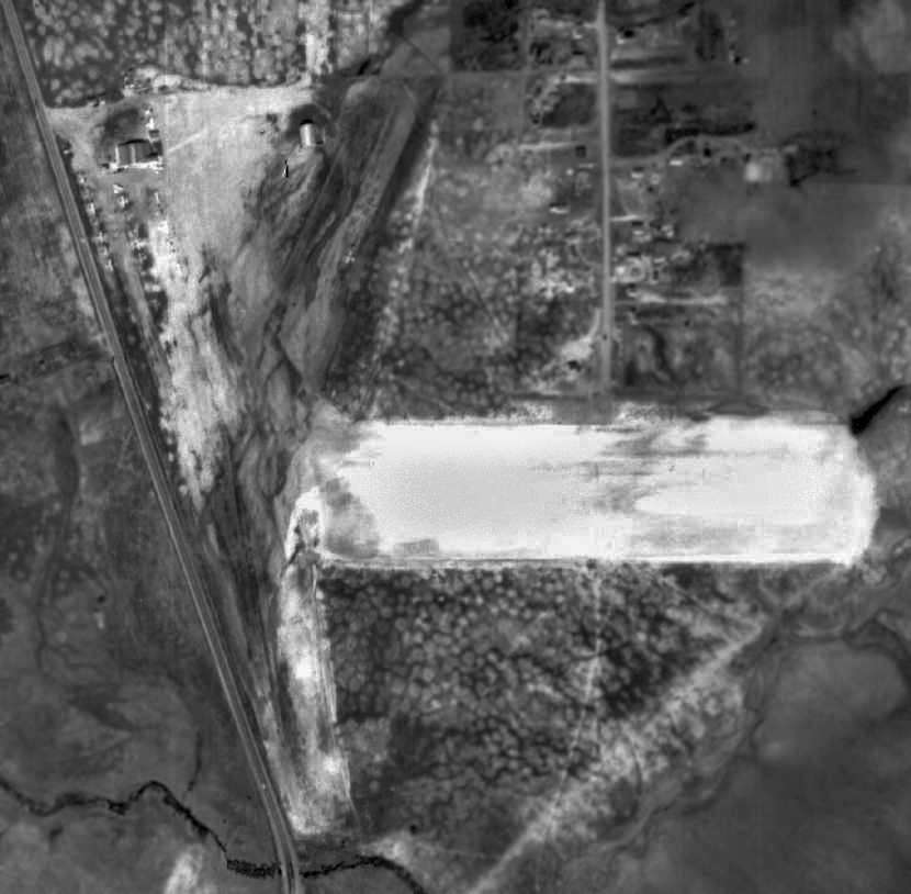
A 2/16/49 USDA aerial photo of the La Pressa Airport (courtesy of Brian Rehwinkel)
depicted the field as having 2 (or possibly 3) unpaved runways,
along with a few small buildings on the northwest corner of the field.
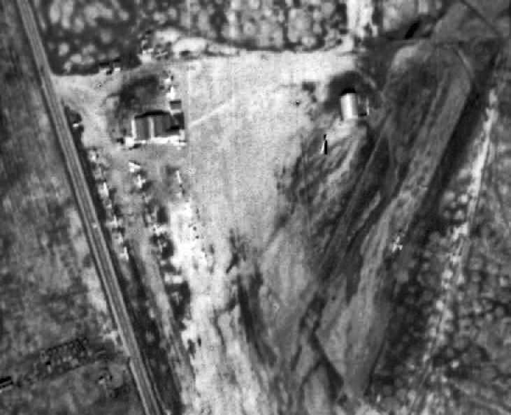
A close-up from the 2/16/49 USDA aerial photo of La Pressa Airport (courtesy of Brian Rehwinkel),
showing over a dozen light aircraft parked at the field.
The 1950 USGS topo map depicted “La Pressa” as a commercial airport.
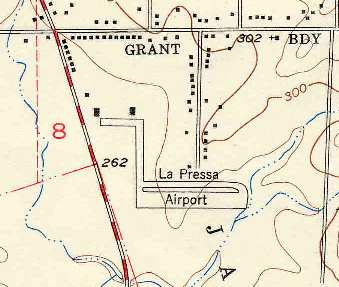
The 1953 USGS topo map (courtesy of Chris Kennedy)
depicted La Pressa Airport as having a somewhat unusual runway configuration,
with a 1,500' east/west runway (with a parallel taxiway along the north side) on the south side of the field,
along with a shorter north/south runway (or taxiway?)
leading to a short east/west taxiway at the northwest corner of the property, along which were 2 buildings (hangars?).
A 1953 street map (courtesy of Kevin Walsh) depicted La Pressa Airport as an L-shaped property outline.
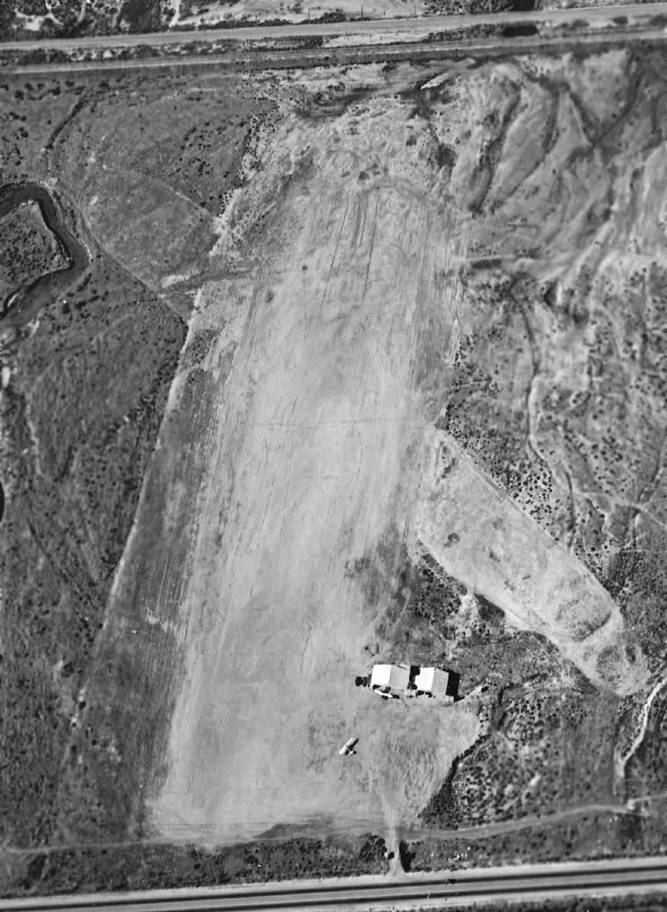
A 1953 aerial photo depicted La Pressa as having 2 unpaved runways, with 15 light aircraft on the west side.
The Aerodromes table on the 1955 San Diego Sectional Aeronautical Chart (courtesy of John Voss)
described “La Presa” Airport as having 2 runways, with the longest being a 2,200' bare strip.
An undated (1950s?) street map depicted “La Presa Airport”.
The last depiction which has been located of La Pressa Airport was on the 1958 USGS topo map.
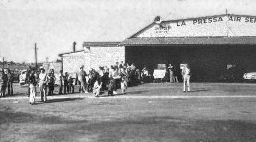
A circa 1950s photo of a gathering outside a La Pressa Air Service hangar.
Possibly taken after the airport's closure, as there appeared to be cars inside the hangar instead of planes.
La Pressa Airport evidently closed at some point between 1955-58,
as it was not depicted at all on the September 1958 San Diego Local Aeronautical Chart (according to Chris Kennedy).
Richard Hardin recalled, “In 1963 the La Presa Airport was a 220 mobile home park called 'Sweet Water Lodge'.
I remember 2 hangars on the old strip that were used for beer storage.
At one end of the park, there was still asphalt from the old airfield.”
By the time of a 1964 aerial photo, the northern portion of the La Pressa Airport site had been redeveloped with housing,
and the southern portion was covered with the Spring Valley Shopping Center.
The 1994 USGS aerial photo did not appear to depict any remaining trace of La Pressa Airport.
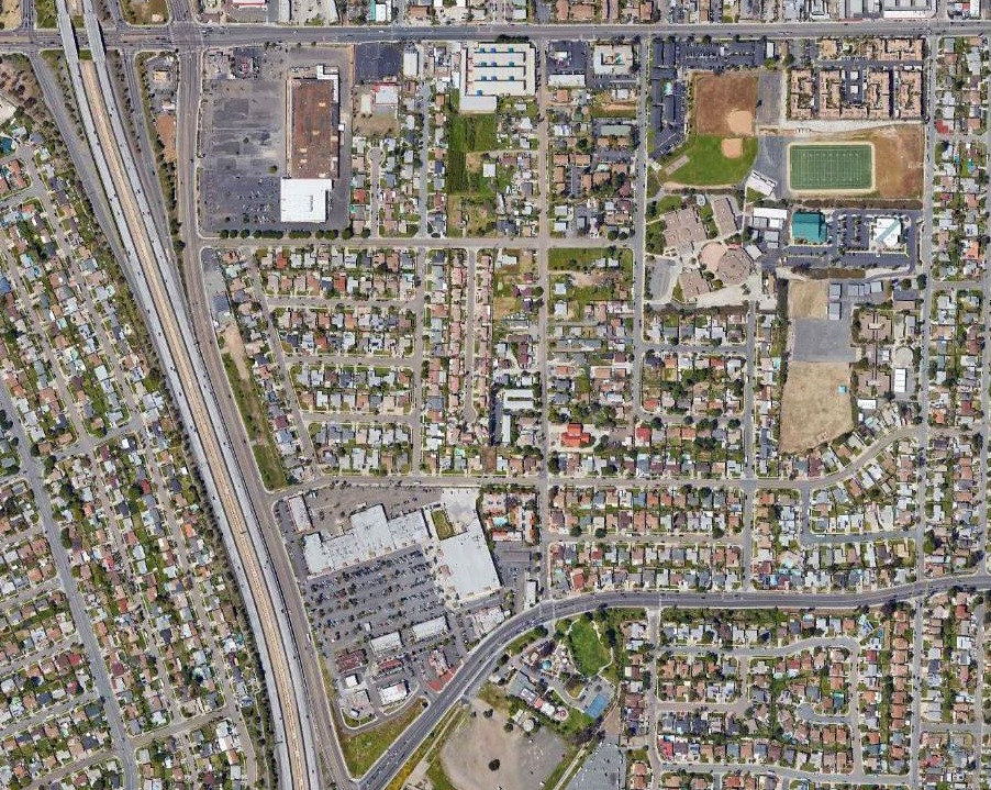
A 2018 aerial photo shows no trace remaining of La Pressa Airport.
The site of La Pressa Airport is located northeast of the intersection of Sweetwater Road & Jamacha Boulevard.
____________________________________________________
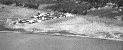
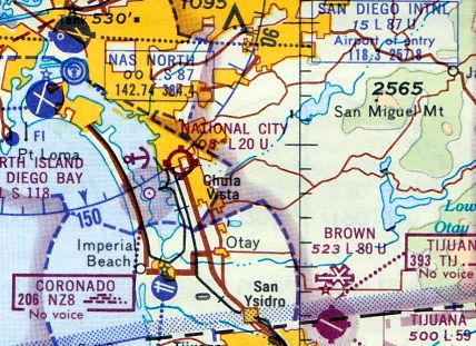
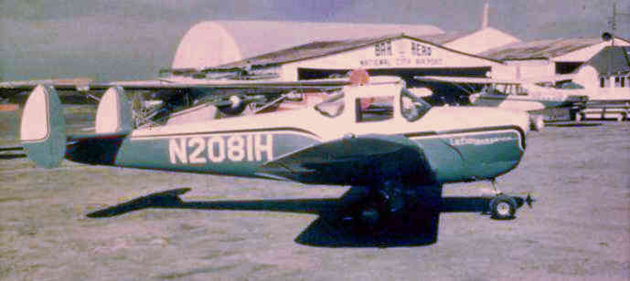
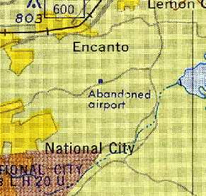
Madson Airport / National City Airport, National City, CA
32.65, -117.1 (Southeast of Downtown San Diego, CA)
An 11/17/39 U.S. Navy aerial view looking west at “Madson Airport” (courtesy of Brian Rehwinkel).
This little general aviation airport was evidently established at some point between 1937-38,
as it was not yet listed among active airfields in The Airport Directory Company's 1937 Airport Directory (courtesy of Bob Rambo).
The earliest reference to Madson Airport which has been located
was in the 1/1/38 US Department of Commerce Airports & Landing Fields Bulletin (courtesy of Scott Murdock).
It described Madson as a commercial airport, located one mile south of National City, on the west side of Highway 101.
The field was said to be irregularly-shaped, containing 2 dirt runways,
oriented 2,000' east/west & 1,700' northeast/southwest.
A hangar roof was said to be marked with “Madson Flying Service”.
Madson Airport was listed in The Airport Directory Company's 1938 Airport Directory (according to Chris Kennedy).
The earliest depiction which has been located of this field
was an 11/17/39 U.S. Navy aerial view (courtesy of Brian Rehwinkel).
It depicted “Madson Airport” as having 2 unpaved runways:
a primary east/west runway, and a much less distinct northeast/southwest strip.
Two small hangars were located on the northeast side,
and 2 small single-engine aircraft were visible near the hangars.
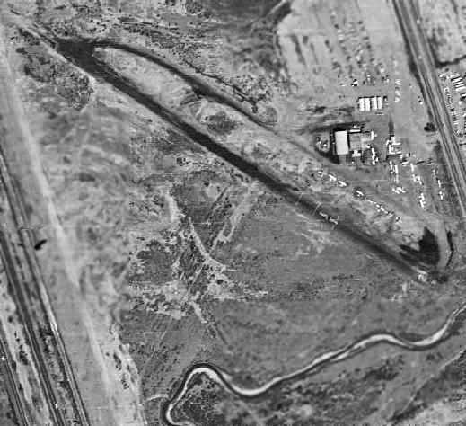
A 1941 aerial view looking west showed Madson Airport to have 2 hangars & 9 light aircraft on the east side of an unpaved landing field.
Madson Airport was still listed in The Airport Directory Company's 1941 Airport Directory (according to Chris Kennedy).
The earliest aeronautical chart depiction which has been located of Madson Airport
was on the December 1941 San Diego Sectional Chart (courtesy of Tim Kukas),
which depicted Madson as a commercial/municipal airport.
Madson Airport was still depicted on the August 1943 San Diego Sectional Chart (according to Chris Kennedy).
Madson Airport was evidently closed at some point between 1943-44
(like many other small general aviation airports near the coasts, due to wartime security concerns),
as the 1944 USGS topo map depicted the site of the airport as a blank, unlabeled area, but it did depict the 2 hangars.
Madson Airport was not depicted on the 1945 San Diego Sectional Aeronautical Chart (courtesy of John Voss).
This airport evidently reopened at some point between 1945-46 as National City Airport,
as that is how it was depicted on the February 1946 San Diego Sectional Chart (courtesy of Chris Kennedy).
The 1948 San Diego Sectional Chart (courtesy of Chris Kennedy)
described National City Airport as having a 2,100' unpaved runway.
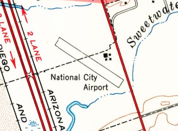
The 1950 USGS topo map depicted “National City” as a commercial airfield.
An undated aerial view looking north at National City Airport from the 1950 Air Photo Guide (courtesy of Kevin Walsh).
The guide depicted National City Airport as having a 2,200' blacktop Runway 9/27, and listed the manager as M.C. Morgan.
The March 1951 San Diego USAF Sectional Chart (courtesy of Chris Kennedy)
depicted National City as having a 2,200' unpaved runway.
The earliest photo that has been located of National City Airport was a 1953 aerial view.
It depicted the field as having a single northwest/southeast paved runway,
with what appeared to be an outline of a former crosswind runway.
A dozen light aircraft were parked around a hangar on the northeast side.
The 1953 USGS topo map (courtesy of Chris Kennedy) depicted National City Airport
as consisting of a single 1,800' northwest/southeast runway.
Several small buildings (hangars) were depicted along the east side of the runway.
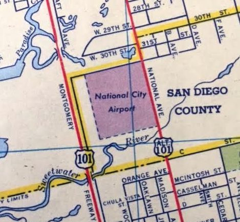
A 1953 street map (courtesy of Kevin Walsh) depicted National City Airport as a square property outline.
The Aerodromes table on the 1955 San Diego Sectional Aeronautical Chart (courtesy of John Voss)
described National City Airport as having 2 runways, with the longest being a 2,200' bare strip.
John Ailshire recalled, “In 1955... I have a vague recollection of my father flying out of a small airport
in what I thought was National City on the west side of what was probably US 101.
The airplane I remember seeing was a 2 seater tandem, overhead wing.”
Ray Ganzer recalled, “I started flying from National City in 1959, after prior closures of the La Mesa Airport (January 1959),
and La Pressa (June 1958); dates taken from my Pilots Logbook.
There were power lines [on the west side of the field],on the railroad right-of way,
which probably helped in the decision to close the field.
I was working for the power company at the time & was asked my opinion about the hazard of the lines.
Of course I said they were no hazard, at least not for me.
I frequently flew out (& in) at night; taking off to the west, landing to the east.
The runway lights were turned on by a switch in one of the buildings,
and left on as long as there was a pilot's note attached.
The lights were staggered - half on one side of the runway to the east end, and the other half on the other side to the west end.
When lining up for a landing at night, I lined up the lights so they appeared as 2 vertical offset lines.
If I was off to the right or left of centerline, the lights would not be vertical lines.
Glide was set up to clear the power lines when landing to the east.
I liked night flying - when the air was smooth.”
A circa 1959 aerial view depicted National City Airport as having a single northwest/southeast paved runway, along with the remains of a former unpaved crosswind runway.
The airport appeared to be at the zenith of its popularity, with a total of 41 light single-engine aircraft visible.
The 1960 Jeppesen Airway Manual (courtesy of Chris Kennedy)
depicted National City Airport as having a single 2,000' paved Runway 10/28,
with a parallel taxiway on the north side leading to a ramp with several buildings on the northeast corner of the field.
Gary Parks recalled, "I remember landing at National City around 1961
and thinking this must be what carrier pilots do as it was a steep approach.
There were wires along the main boulevard to the east as well as homes on a small bluff to the southeast.
So as soon as you cleared those you dropped down to the crumbling asphalt runway.
I liked going there because they used to fly T-6s out of there (civilian).
The takeoff was equally as exciting as there were high-power lines paralleling Highway 101
not far to the west that were marked with red balls."
The 1962 San Diego Local Aeronautical Chart (courtesy of John Voss) depicted National City Airport as having a 2,000' hard-surface runway.
A 1964 aerial view depicted National City Airport as having a single northwest/southeast paved runway,
with what appeared to be an outline of a former crosswind runway.
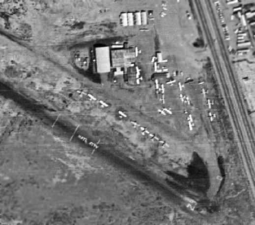
A closeup from the 1964 aerial view depicted several hangars & 28 single-engine aircraft on the east side of the field.
Note the “Natl City” painted on the runway – apparently the extra 4 letters to completely spell “National” would've been too expensive!
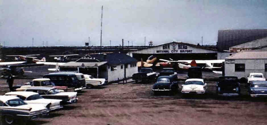
A 1964 photo by E.J. Fine of National City Airport from the east side street entrance,
showing several planes (including a T-6 Texan) around the Bar Aero hangar.
E.J. Recalled, “The third car up on the left is my '57 Ford Fairlane.
I started flying there in 1954. I received my Private Pilot certificate at National City Airport in 1955.”
The last aeronautical chart depiction which is available of National City Airport
was on the August 1965 San Diego Sectional Chart (courtesy of Ron Kunse).
A December 1965 aerial view looking north at National City Airport by Ray Ganzer.
It depicted the field as having a single northwest/southeast paved runway,
with what appeared to be an outline of a former crosswind runway.
Several light planes were visible parked on the east side of the field.
A December 1965 photo by Ray Ganzer of an Ercoupe at National City Airport, with the hangars of Bar Aero in the background.
By 1966, the end was obviously near for National City Airport,
as the 1966 San Diego Sectional Aeronautical Chart (courtesy of Chris Kennedy)
depicted it as having a mere 1,000' runway.
The Aerodromes table on the chart explained it as a 1,000' bituminous runway on a 2,000' gravel strip,
with the remarks saying, "West half of runway gravel closed when wet."
According to Mary Oswell of the Bonita Historical Society,
“The property was sold in January 1966 to San Diego Imperial Corporation to create an industrial park.
The airport closed about a month later.
It was the last privately-owned airfield in San Diego County.
I grew up in the area & I don’t remember it (I was born in 1963),
so they must have begun construction of the industrial park pretty soon after the airport closed.”
National City Airport was no longer depicted at all on the August 1976 LA San Diego Sectional Chart (according to Chris Kennedy)
or on the 1978 USGS topo map.
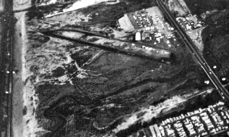
A 1980 aerial view depicted several buildings covering the southern portion of the airport site.
Not a trace appeared to remain of National City Airport.
A 1989 aerial view showed a canal had been built across the northern part of the National City Airport site.
A 2018 aerial view looking north showed no trace remaining of National City Airport, with the location occupied by a drainage canal & buildings.
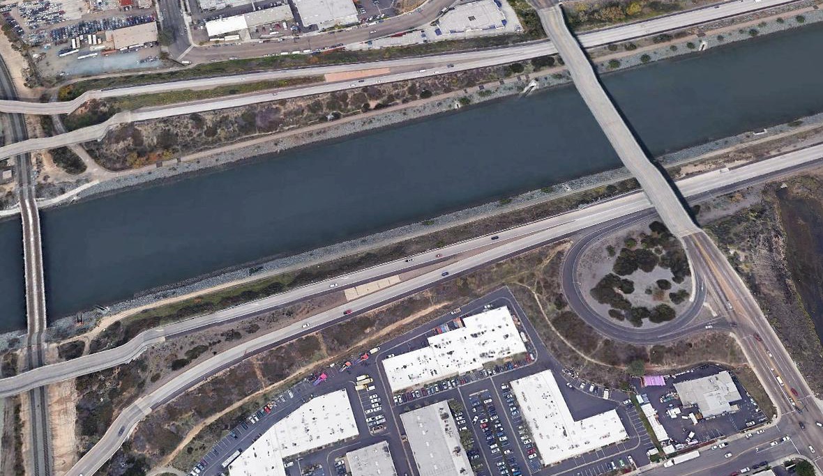
The site of National City is located west of the intersection of National City Boulevard & West 35th Street.
____________________________________________________
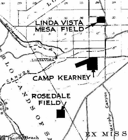
Rosedale Naval Outlying Landing Field, Clairemont, CA
32.824, -117.174 (North of Downtown San Diego, CA)
“Rosedale Field”, as depicted on the June 1938 “Map Showing Locations of Leased Auxiliary Landing Fields,
Naval Operating Base San Diego” (courtesy of Brian Rehwinkel).
The date of construction of the Rosedale airfield has not been determined.
The earliest depiction of the field which has been located
was on the June 1938 “Map Showing Locations of Leased Auxiliary Landing Fields,
Naval Operating Base San Diego” (according to Brian Rehwinkel).
It depicted “Rosedale Field” simply as a square outline.
Rosedale Field was not yet depicted on the 1938/40/42 San Diego Sectional Aeronautical Charts.
During WW2, Rosedale NOLF was used as one of at least 12 auxiliary airfields attached to San Diego NAS (North Island).
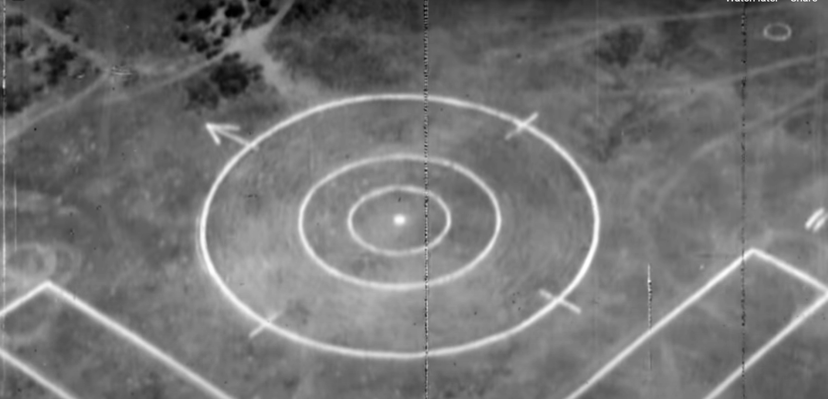
A still from an early 1940s movie showing the Rosedale Field dive bomber target (courtesy of John Pollard).
According to David Siegenthaler, “Rosedale Field was used for dive bombing practice.
The field is shown in live motion in an early 1940s dive bombing training film from the cockpit of a dive bomber aimed at a very clearly delineated target.
My uncle, David Beck, died in a practice Navy dive bombing exercise in 1942.
He was flying an SBC-4 Navy dive bomber biplane which he apparently failed to pull out of a dive in time.
The crash site had been reported to be on the northern boundary of Rosedale Field.”
Rosedale Field was not yet depicted on the August 1943 San Diego Sectional Aeronautical Chart (courtesy of Ron Plante).
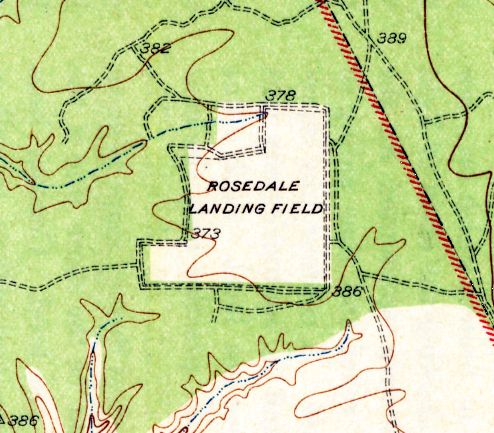
The 1943 USGS topo map (courtesy of Chris Kennedy)
depicted the "Rosedale Landing Field" simply with an irregularly-shaped boundary of the property.
A 1/5/44 National Archives aerial view of Rosedale Field (courtesy of Brian Rehwinkel)
depicted the field as being roughly square shaped, with several cut-outs on the north side, including an olive grove which remained for years.
There did not appear to be any buildings or other improvements associated with the airfield.
David Siegenthaler observed, “The photo shows remnants of the bombing target in the northwest section of the field, and an olive grove on the north boundary of the field.”
The earliest aeronautical chart depiction which has been located of Rosedale Field was on the March 1944 San Diego Sectional Chart.
It depicted Rosedale as an auxiliary field.

The airfield configuration depicted for “Rosedale Field / #00508” in a circa 1944 directory of NAS San Diego airfields (courtesy of Brian Rehwinkel)
was considerably different from how the field was previously depicted.
It described the field as having a single 1,500' adobe Runway 9/27.
This was presumably on the southern portion of the former airfield area, with the northern portion no longer used as a landing area.
Rosedale Field was described as being assigned to NAS San Diego for administrative & maintenance purposes.
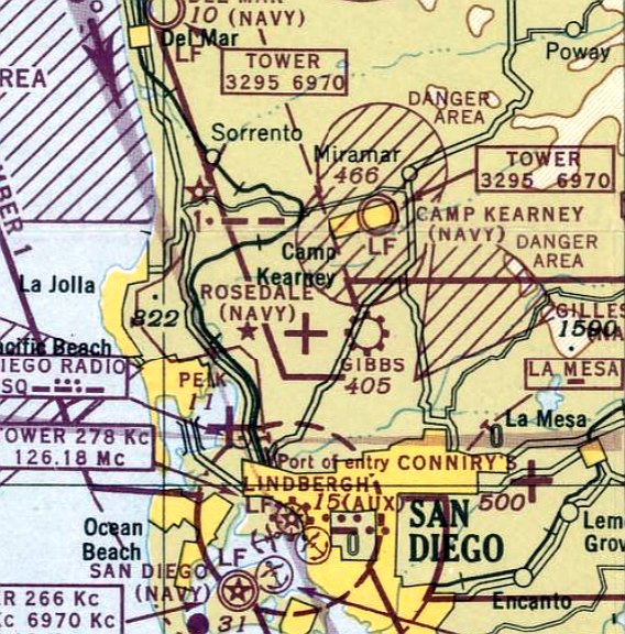
The last aeronautical chart depiction which is available of Rosedale Field on the March 1948 San Diego Sectional Chart (courtesy of Ron Plante).
It depicted the “Rosedale (Navy)” airfield as having a tiny 1,000' unpaved runway.
Rosedale Field was no longer depicted on the September 1948 San Diego Sectional Chart
or the 1950 USGS topo map.
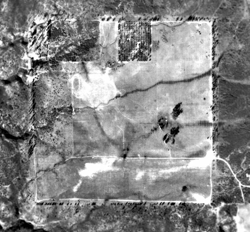
A 1953 aerial photo showed Rosedale Field remained clear.
A 1964 aerial photo no longer showed any trace of Rosedale Field,
with the area having been densely redeveloped at some point between 1953-64.
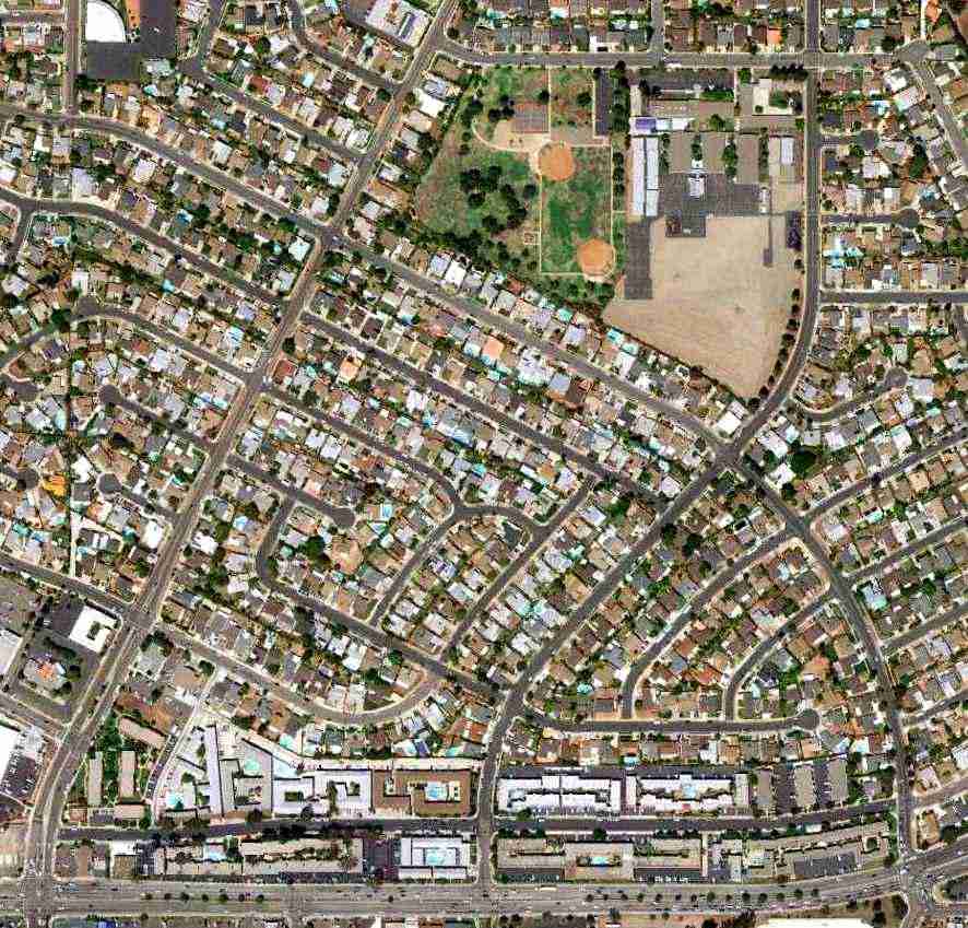
A 8/24/10 aerial view of the site of Rosedale NOLF shows the area to have been densely developed,
with not a trace appearing to remain of the former airfield.
Thanks to John P. for determining the specific location.
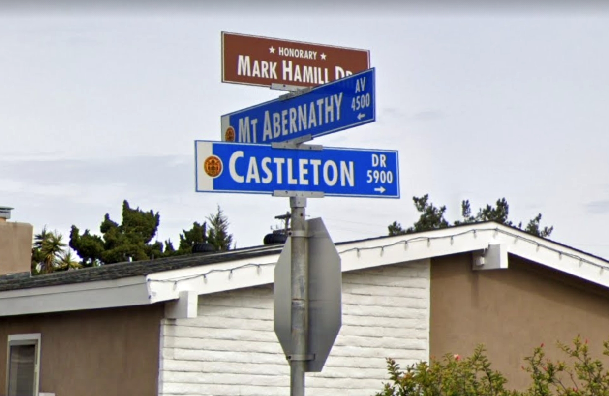
A February 2019 photo of the street sign which commemorates the location of the former home of movie pilot Mark Hamill, which happens to be on the site of Rosedale NOLF (courtesy of John Pollard).
The site of Rosedale Landing Field is located northeast of the intersection of Mt. Abernathy Avenue & Balboa Avenue.
____________________________________________________
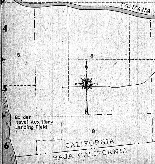
Border Naval Outlying Landing Field / Border Field, South San Diego, CA
32.54, -117.12 (North of Tijuana, Mexico)
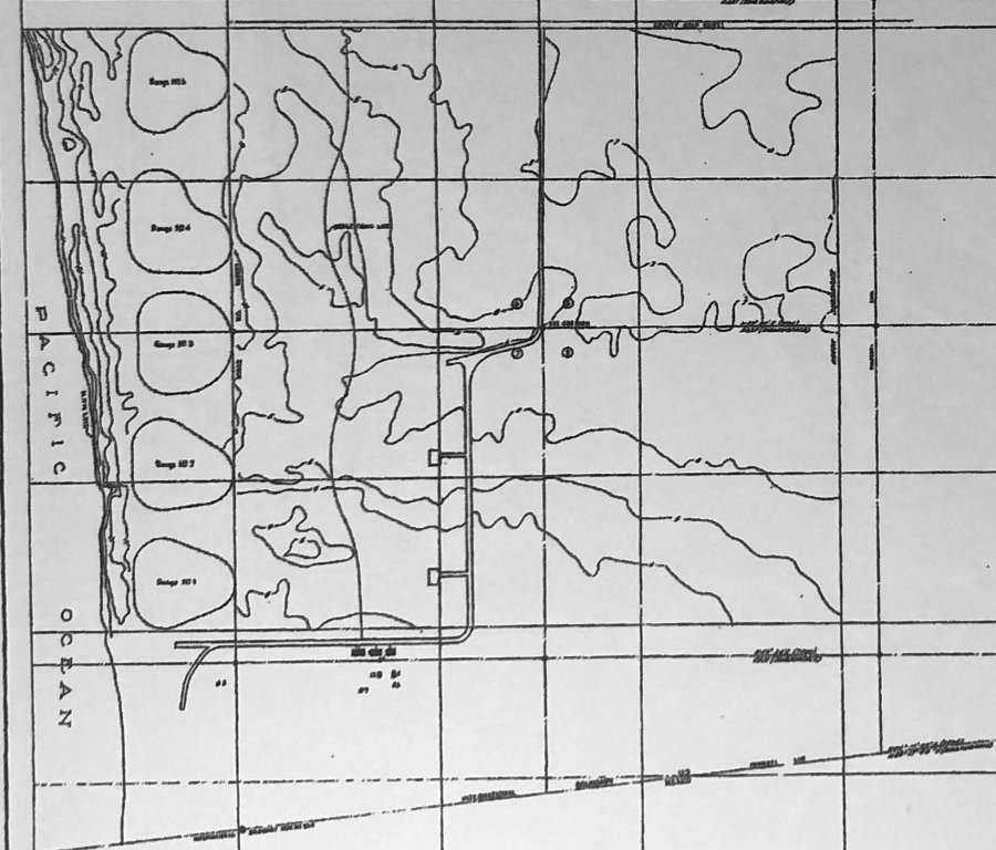
A 6/30/42 “Map of Border Field Naval Operating Base” (courtesy of Michelle Landis).
Photo of the airfield while in use has not been located.
Border NOLF was built during WW2 as one of at least 12 auxiliary airfields attached to San Diego NAS (North Island).
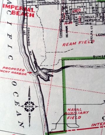
It consisted of 100 acres located along the Pacific coast south of Ream Field (later to become Imperial Beach NOLF),
and directly north of the Mexican border.
Border Field was was not depicted among active airfields on the San Diego Sectional Aeronautical Charts from 1941/42/44/45/48/49/55.
The original runway configuration at Border Field is unknown, presumably an unpaved field.
An undated WW2-era Navy Airfield planning document (courtesy of John Voss)
included "Recommended Development: One 'standard' runway into the prevailing wind."
It also said, "Proposed Use: Dive bombing; gunnery training; and practice landings during dry weather."
Naval pilots received gunnery training at Border Field.
The earliest depiction which has been located of Border Field was a 6/30/42 “Map of Border Field Naval Operating Base” (courtesy of Michelle Landis).
It depicted 5 curved presumed target ranges along the ocean shore to the west, but did not appear to depict any airfield facilities.
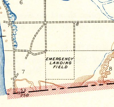
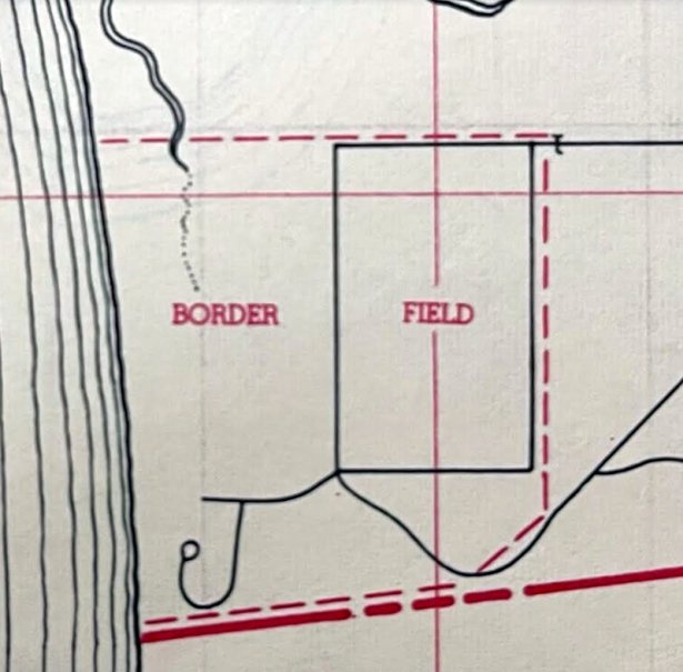
The earliest topo map depiction which has been located of Border Field was on the 1943 USGS topo map (courtesy of Scott O'Donnell).
It depicted a square property outline labeled generically as “Emergency Landing Field”.
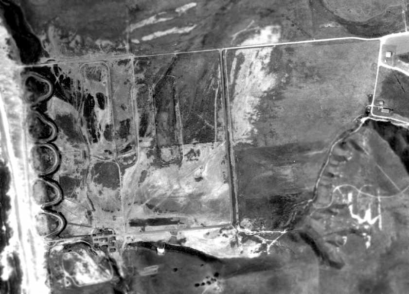
A 4/14/45 USDA aerial photo of Border Field (courtesy of Brian Rehwinkel).
It depicted 5 curved presumed target ranges along the ocean shore to the west, but did not appear to depict any airfield facilities.
Michelle Landis observed, “There was a north/south runway on the beach & possibly an east/west runway along Monument Road.
The rectangle with the circle in it (center of the image) was a bombing target range (dummy bombs dropped for training). This is referenced in a USACE report.
The oval-shaped tracks along the dunes were a part of an air strafing training range with tracks & moving targets, later a ground-level machine gun training range until the mid-1950s.
The long snakelike form was a moving target training track for aircraft strafing training; these targets were pulled by Jeeps.”
According to the August 1969 issue of “Naval Aviation News” (courtesy of John Voss),
Border Field was redesignated a “target drone training area & emergency landing strip” in early 1950.
Border Field, as depicted rather simplistically on a 1953 road map (courtesy of Kevin Walsh).
Bob Raczkowski recalled, “My dad was a U.S. Navy pilot at Brown Field in VU-3, a drone squadron.
He took me to Border Field in 1956 to watch the launch, test, and recovery of the small TDD drones from steam catapults just above the beach; lots of fun for a 4th grader.”
Border NALF, as depicted on a 1956 street map (courtesy of Chris Kennedy).
According to the August 1969 issue of “Naval Aviation News” (courtesy of John Voss),
in 1961 Border Field was turned over to the GSA, then the Naval Electronics Lab for research.
Border Field was still labeled "Naval Auxiliary Field" on the 1961 street map (courtesy of Kevin Walsh).
A 1964 aerial view still depicted a row of small buildings along the west edge of Border Field.
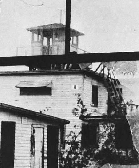
An undated photo of an abandoned building (with what appears to be a control tower on top) at Border Field,
from the August 1969 issue of “Naval Aviation News” (courtesy of John Voss).
According to Jill Holslin, the Border NOLF land was granted by the Navy on 2/21/73 “first to the Department of the Interior,
then DOI passed it to the National Park Service, and then it was deeded to California State Parks.”
The site was still labeled "Border Field Naval Reservation" on the 1975 USGS topo map.
The only remaining clue to the original runway configuration is the "C"-shaped outline
of the "Border Field Naval Reservation" on the 1976 USGS topo map.
This could indicate that there presumably was a 4,000' north/south landing area along the beach,
along with a 3,000' east/west strip extending inland from the north end & a 2,000' strip extending inland from the south end.
A very rough conjecture, though.
The site of the former airfield was labeled "Border Field State Park" on the 1979 USGS topo map.
The park has been called "California's Ugliest State Park"!
A 1980 aerial view showed that the buildings along the western edge of the field had evidently been removed at some point between 1964-80.

Unlike the vast majority of other San Diego area NOLFs, the area at Border Field was not redeveloped,
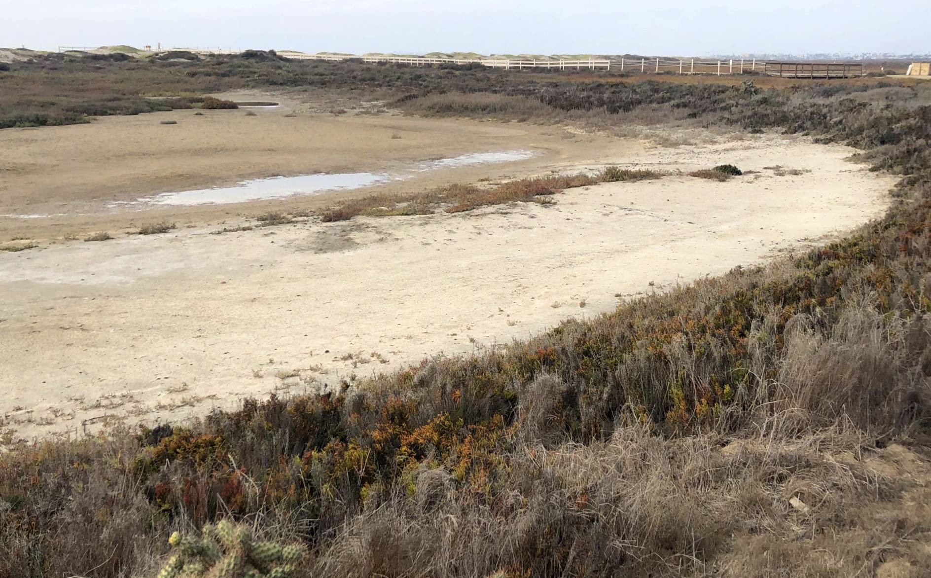
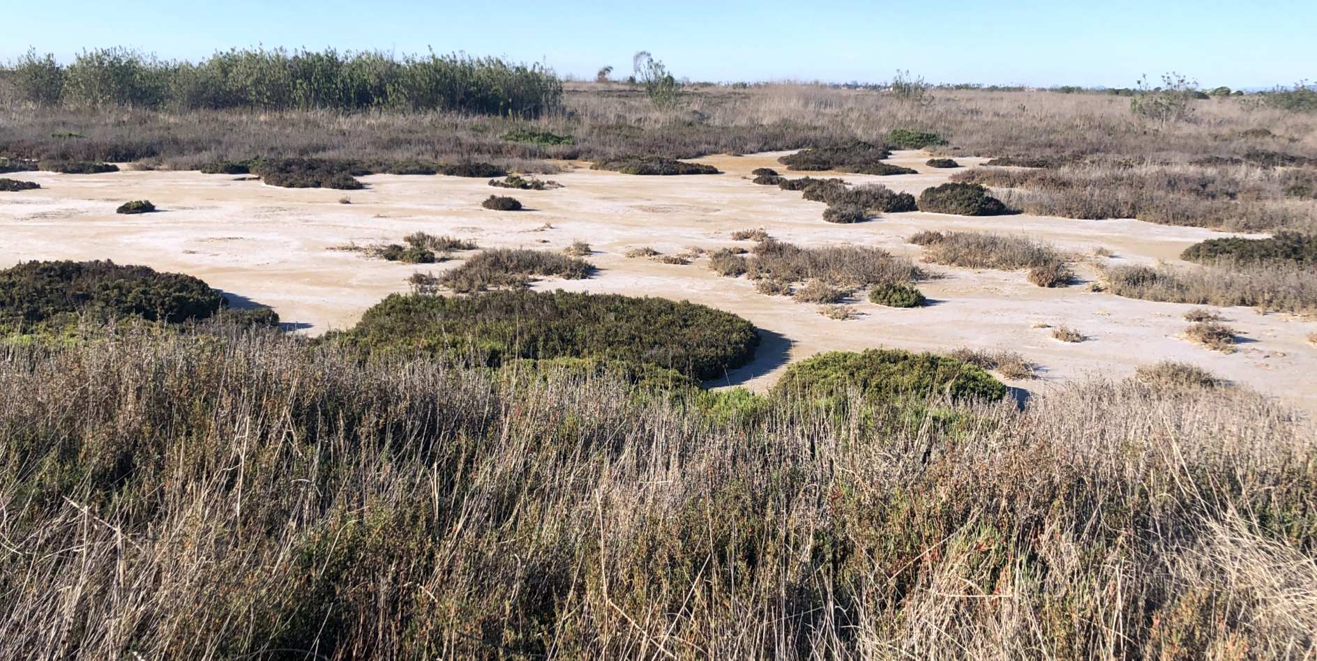
but traces of any runways were no longer apparent in a 2020 aerial photo.
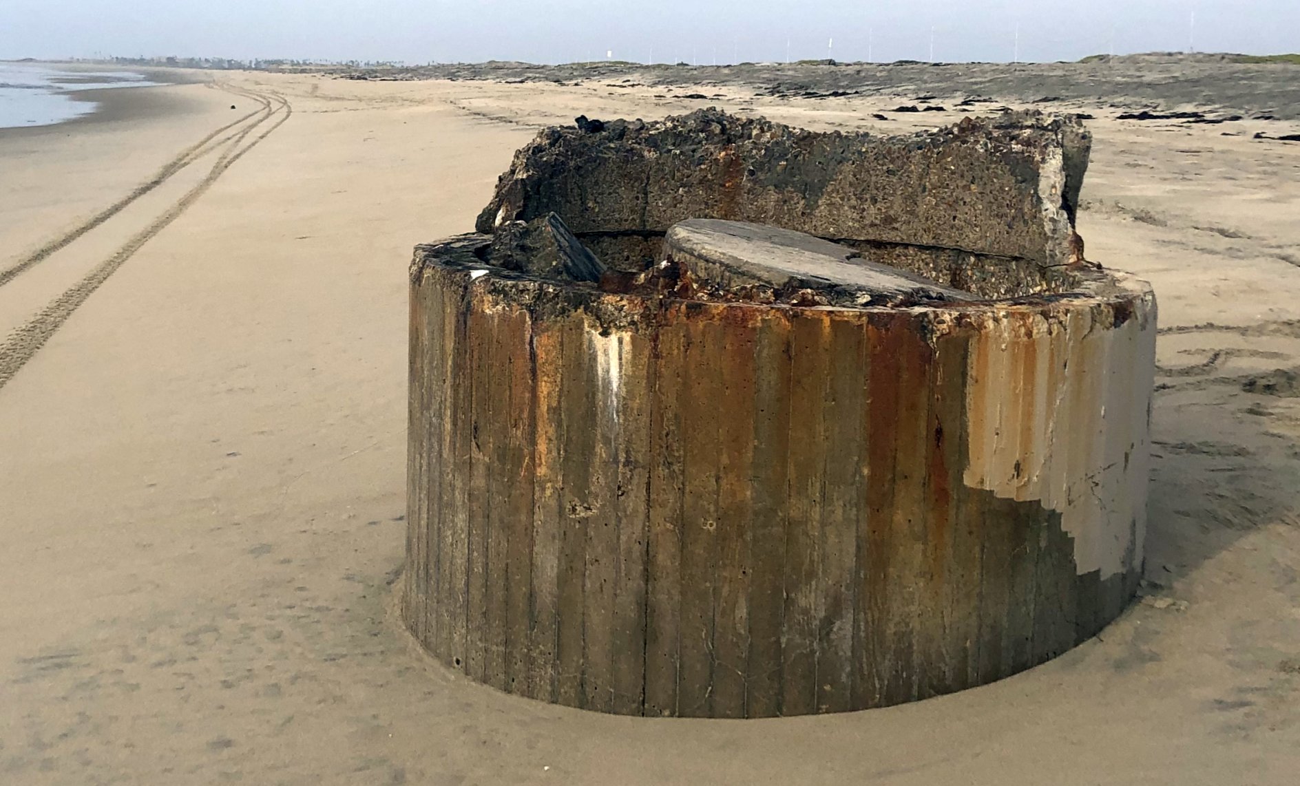
A 2/5/22 photo by Michelle Landis looking north at the Border Field beach of a “Board-formed concrete structure consistent with WW2 or earlier forming techniques.
This was taken at the western point of Monument Road & lies close to the northern edge of the strafing range. Maybe an observation platform to assess trainees?”
A 2/5/22 photo by Michelle Landis at Border Field of “the northern-most oval strafing track along Monument Road; the southern ones lie in an ecologically 'off limits' area.”
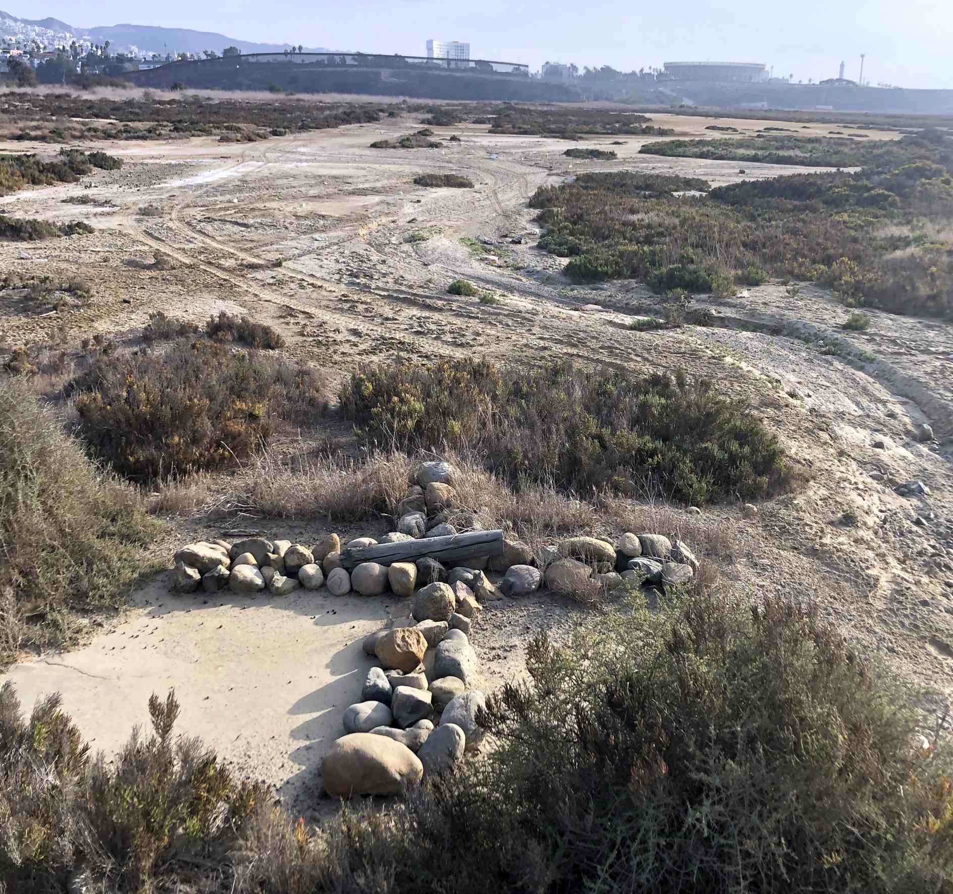
A 2/5/22 photo by Michelle Landis looking southwest at Border Field of “An interesting concrete pad & marker located along Monument Road.
I think this either marks the edge of the strafing range or maybe the eastern end of the Monument Road.”
A 2/5/22 photo by Michelle Landis at Border Field of “the general area where the circular target was located.
The vegetation was pretty dense, so I was not able to find remnants noted in a government ordnance study.”
Border Field is located at the western terminus of Monument Road, just north of Tijuana.
Thanks to John Voss for information about Border Field.
____________________________________________________
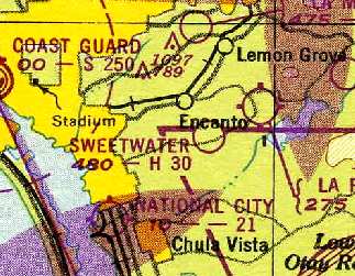
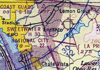
Sweetwater Dam Naval Outlying Landing Field / Sweetwater Airport, Encanto, CA
32.693, -117.042 (Southeast of San Diego, CA)
“Sweetwater Dam (Navy)”, as depicted on the February 1946 San Diego Sectional Chart (courtesy of Chris Kennedy).
Sweetwater Dam NOLF was built during WW2
as one of at least 12 auxiliary airfields attached to San Diego NAS (North Island).
The Sweetwater airfield was not yet depicted at all
on the 1944 USGS topo map nor on the March 1944 San Diego Sectional Chart (according to Chris Kennedy).
According to Brian Rehwinkel, “This field was built in late 1944 (along with Ramona OLF) for carrier landing practice.”
The earliest depiction of the field which has been located
was on the 1945 San Diego Sectional Aeronautical Chart (courtesy of John Voss).
It labeled this field "Sweewater Dam (Navy)".
The field was reportedly also known as Paradise Mesa.
The February 1946 San Diego Sectional Aeronautical Chart (courtesy of Chris Kennedy)
still depicted the field as "Sweewater Dam (Navy)".
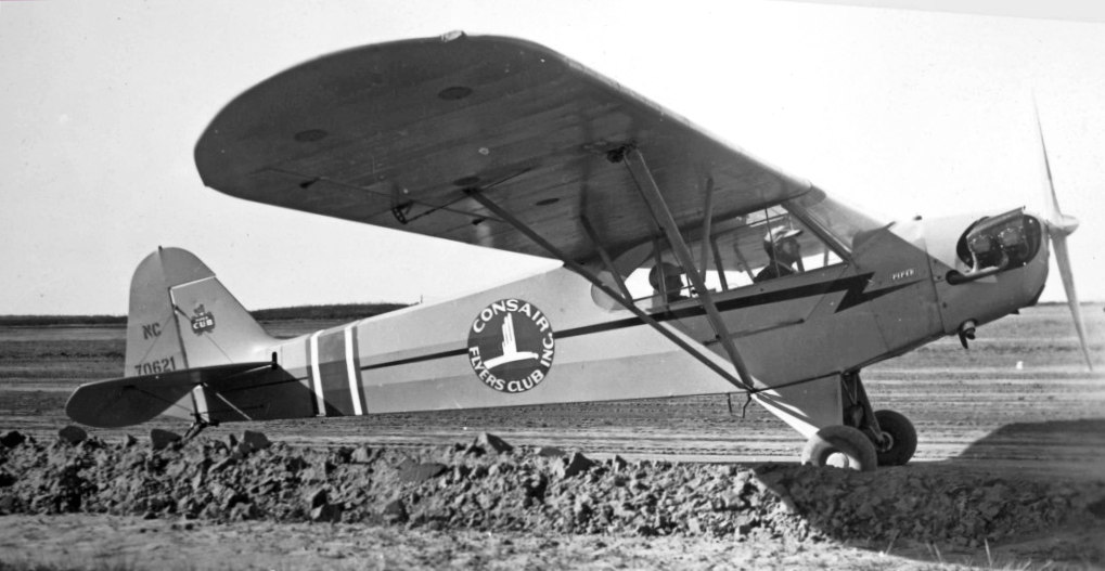
The only photo which has been located showing an aircraft at Sweetwater was a 1946 photo of a Piper J-3C Cub of the Consair Flying Club at the “Sweetwater Air Ranch”.
On 4/11/46 Sweetwater Airstrip was the site of perhaps the Navy's 1st helicopter accident in the San Diego area, as documented by a Navy accident report (courtesy of Brian Miller).
Brian Miller observed, “Captain Clayton Marcy was one of the Navy's first helicopter pilots.
He was actually more or less the 'Father' of Navy rotary-wing aviation who took helicopter development from the first days of WW2 to the first operational squadrons in 1948.
On the day of this accident, he was simply gaining familiarity & practice with the new HOS-1 helicopter [#75616].
This flight was simply practice & about as routine as they come. It was one of the first flights of the deployment since leaving Norfolk in early March.”
In the course of his 1st solo flight in the HOS-1, Marcy attempted an autorotative glide, but his flare was made too low, resulting in a tail rotor strike.
Sweetwater Dam NOLF was apparently deactivated by the military at some point between 1946-48,
as it was not depicted at all on the 1948 San Diego Sectional Chart (courtesy of Chris Kennedy).
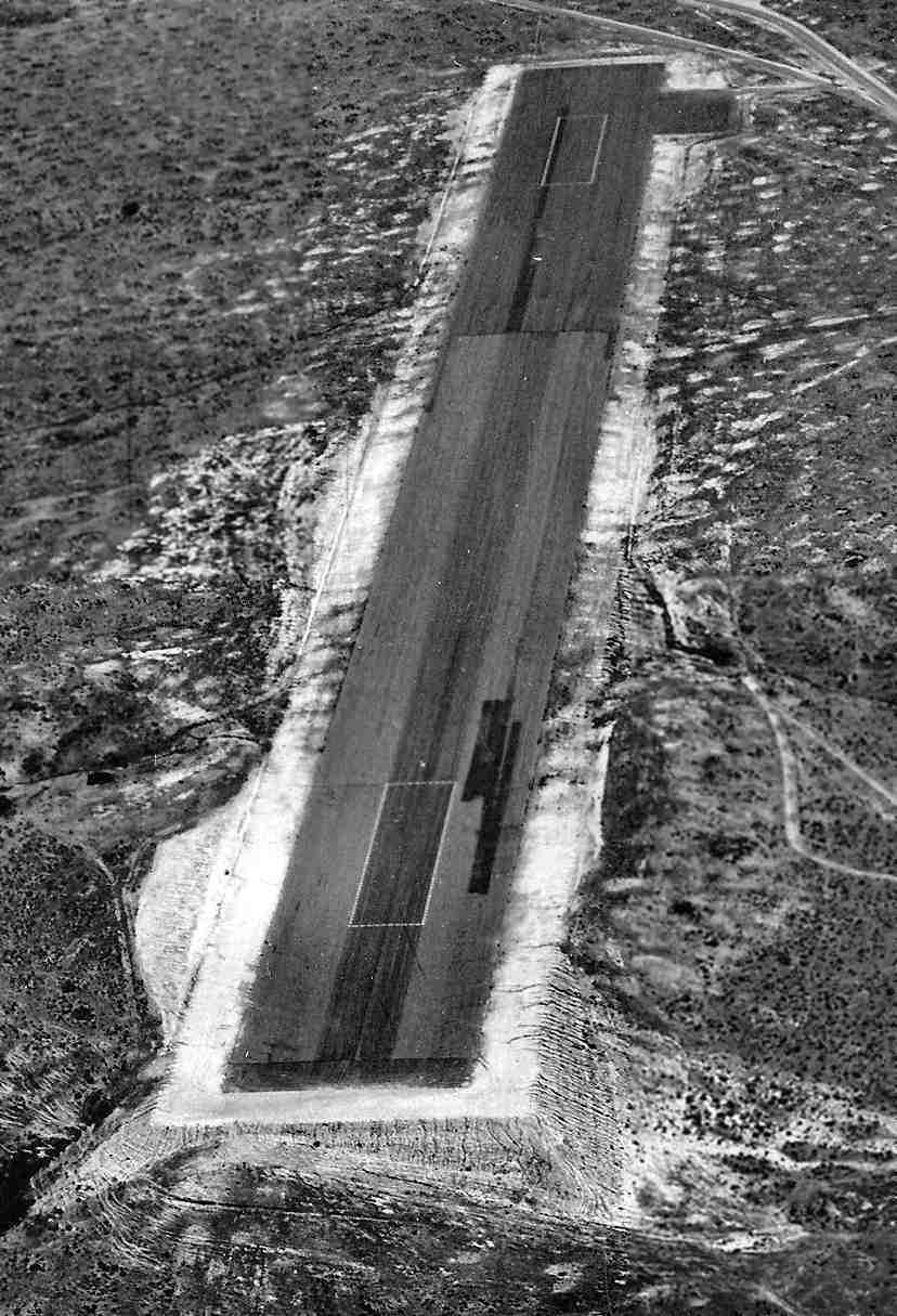
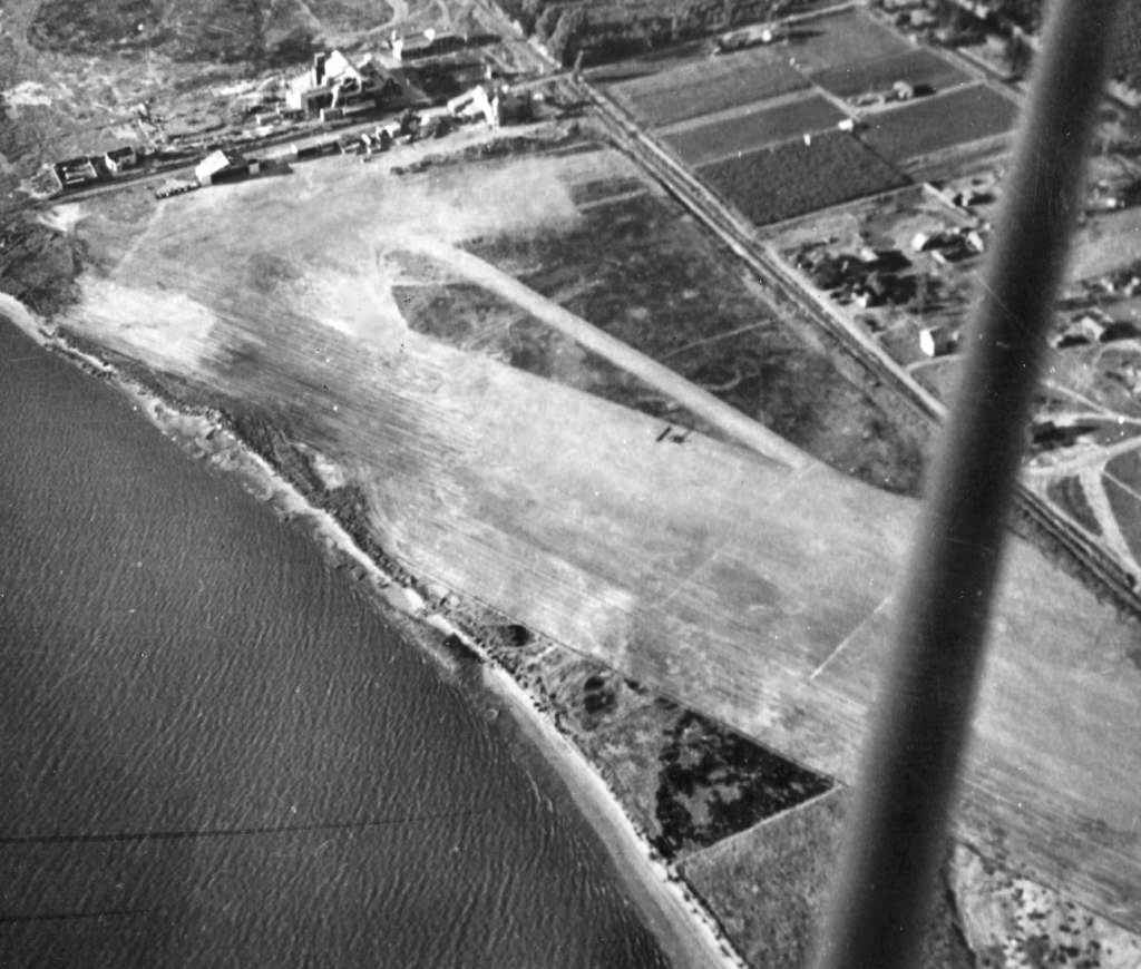
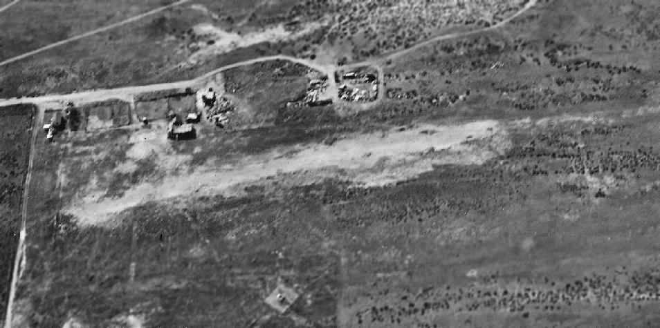
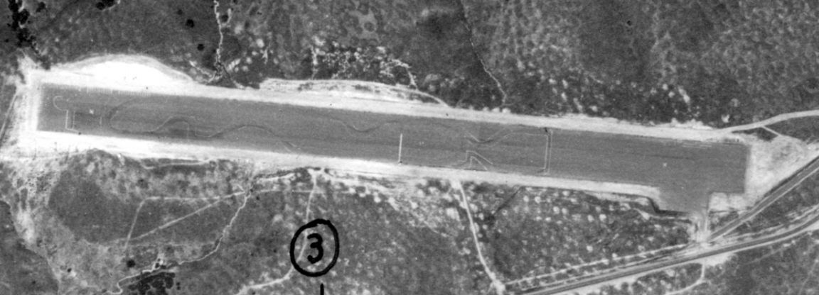
A May 1948 U.S. Navy aerial view (courtesy of Brian Rehwinkel) looking east at Sweetwater Dam OLF.
Brian observed, “It shows a pilot’s view on final approach. You can see the steep drop off at the end of the field.
It gives you an idea of how hilly the terrain was around this field – and how a great deal of foundation work had to be done in order to build this field in these hills.
These photos are a part of a series of shots the Navy took in May 1948 of OLFs in Sothern California.
I am presuming, but I don’t know, the Navy was still using these fields
(or, at least still was in possession of the fields, especially since the title on these photos refers to the field as 'OLF Sweetwater Dam').”
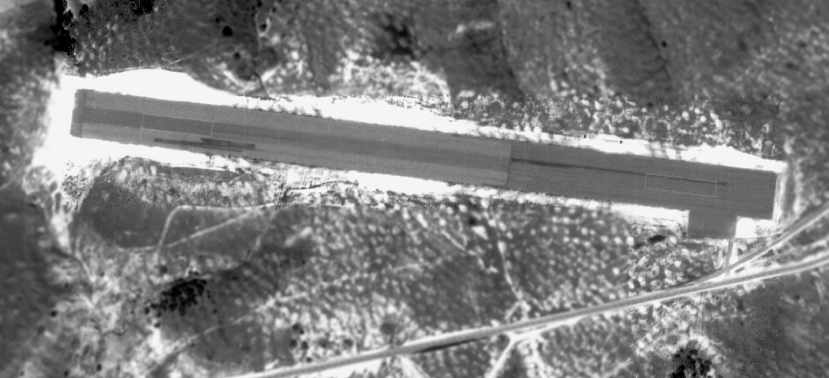
A 2/16/49 USDA aerial photo of the Sweetwater Dam airfield (courtesy of Brian Rehwinkel)
depicted the field as having a single east/west asphalt runway,
with a small parking pad on the southeast side.
The field did not appear to have any buildings.
Brian observed, “You can see the landing areas (rectangular) painted on the field.
It is interesting to see how undeveloped this area was in 1949.”
At some point between 1948-49 the Sweetwater airfield was apparently reopened as a civil airfield,
as that is how it was depicted on the 1949 San Diego Sectional Chart (courtesy of Chris Kennedy).
Note that the same chart also depicted a "Sweetwater Springs" airport a few miles to the east.
The 1950 USGS topo map depicted “Sweetwater” as a private airfield.
The March 1951 San Diego USAF Sectional Chart (courtesy of Chris Kennedy)
depicted Sweetwater as having a 3,000' hard surface runway.
A 1953 aerial photo depicted the the Sweetwater Dam airfield as having a single east/west asphalt runway,
with a small parking pad on the southeast side.
An undated (1950s?) street map depicted Sweetwater Airport.
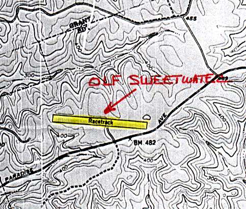
The 1953 USGS topo map (courtesy of John Voss) depicted the runway of the former NOLF Sweetwater, by that time labeled "Racetrack" .
The last aerial photo which has been located of the Sweetwater Dam airfield was a 4/14/53 aerial view (from the UCSB Library).
It depicted Sweetwater Dam Airfield as having a single east/west asphalt runway, with a small parking pad on the southeast side.
An auto racing outline was perceptible on the runway.
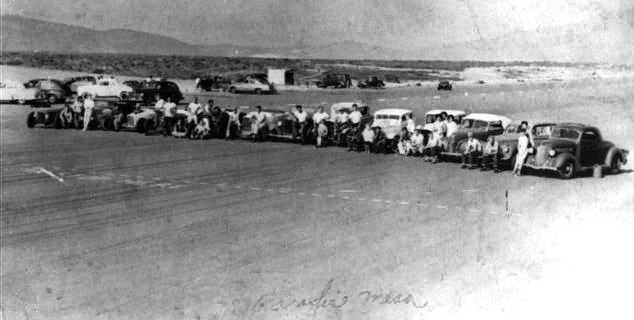
The last photo which has been located of the Sweetwater Dam airfield was a 1954 photo (courtesy of Tony Cantarini) of drag racers on the “Paradise Mesa” dragstrip.
Tony Cantarini recalled, “I was born in Paradise Hills in 1961.
I did hear a lot about the [airfield] named Sweetwater Dam NOLF, even though none of the stories involved aircraft or the use of that name.
The many stories about it came from my Dad, Mom, Uncle and their high school friends that used it from the late 1940s until 1959.
They always called it Paradise Mesa Airstrip.
There were many stories of how they would line up with 8 cars & race.
The fastest 4 would turn around & race back followed by the other 4.
Eventually this would continue until 4 were going one way & 4 were coming the other way.
If everyone observed 'the imaginary center line' there wouldn't be a problem.
Unfortunately, accidents happened & the West end of the strip saw tragedy also, due to a steep drop near the end of the runway.
I can see why it was used for carrier landing practice.
The west end must have looked like an aircraft carrier.”
Tony continued, “The guys that were serious about racing grew tired of being chased off by the police,
so they organized and suddenly the beginnings of the NHRA evolved & events were held on weekends from 1951-59.
My Dad & many others still used it during the week.
The police would try to run the street racers off the strip or catch them, but their under-powered police cars couldn't catch anyone.
At the time, there was open land, canyons & trails in all directions from the Mesa and getaways were easy.
When me & my brother were old enough to ride bikes, our Dad took us on all the trails,
where we soon started to ride motocross in these areas which remained mostly undeveloped during the 1960s & 1970s.”
Tony continued, “I can't think of any practical commercial use it could have been used for... it was so isolated.
Maybe if someone would have started a flight school it may have lasted much longer. I have my doubts.
My guess is that the family that owned the huge chunk of land east of National City
are the ones that live in the Spanish mansion at the west end of Paradise Valley Road.
Every 5 to 10 years, they would sell off sections of land to developers.
I never knew the limits of their land but my Dad told me they would lease large areas to cattle owners.”
Tony described a DVD which described drag racing at the (Sweetwater) Paradise Mesa airfield:
“One of the interviews talks about how they had to get permission
from 'the woman that owned the land' (a phrase my Dad used) in order to have sanctioned racing.
They also had to pay her an annual fee of a dollar. I wonder how much she charged the Navy?”
Sweetwater was still listed among active airfields in the Aerodromes table
on the 1955 San Diego Sectional Aeronautical Chart (courtesy of John Voss).
It described the field as having a single 3,000' bituminous runway,
and included the remark, "Auto racing on field. Closed weekends."
The Sweetwater Airport was evidently closed at some point between 1955-58,
as it was no longer depicted at all on the September 1956 San Diego Sectional Chart (according to Chris Kennedy).
According to auto racing historian Bret Kepner,
the Sweetwater runway was used as a commercial drag strip until 1959.
By the time of the 1962 San Diego Sectional Chart (courtesy of Chris Kennedy),
the former Sweetwater Dam NOLF was labeled as "Abandoned Airport".
A 1964 aerial view showed that the site of the Sweetwater Dam airfield had been covered with houses.
Fulton Recepcion recalled, "I grew up about 1.5 miles west of the former OLF site.
I lived in Paradise Hills [the present-day community at the location of the former airfield] from 1977-91.
I think the houses [built over the site of the former airfield] went up in the late 1960s & early 1970s."
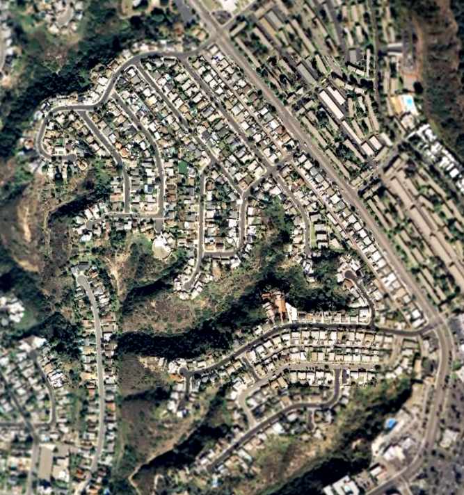
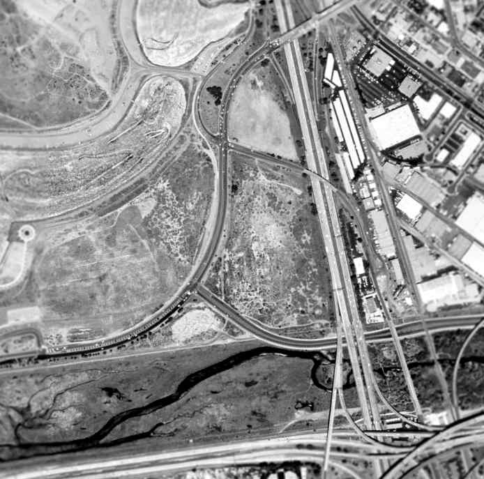
A 2016 aerial photo shows the Sweetwater Airport property has been completely redeveloped with houses, with not a trace remaining of the former airfield.
The site of Sweetwater Dam NOLF is located north of the present-day intersection of Paradise Valley Road & Briarwood Road.
Thanks to John Voss for information about Sweetwater.
____________________________________________________
Since this site was first put on the web in 1999, its popularity has grown tremendously.
If the total quantity of material on this site is to continue to grow,
it will require ever-increasing funding to pay its expenses.
Therefore, I request financial contributions from site visitors,
to help defray the increasing costs of the site
and ensure that it continues to be available & to grow.
What would you pay for a good aviation magazine, or a good aviation book?
Please consider a donation of an equivalent amount, at the least.
This site is not supported by commercial advertising –
it is purely supported by donations.
If you enjoy the site, and would like to make a financial contribution,
you
may use a credit card via
![]() :
:
Please consider checking the box to make a monthly donatation.
For a mailing address to send a check, please contact me at: paulandterryfreeman@gmail.com
If you enjoy this web site, please support it with a financial contribution.
This site covers airfields in all 50 states.