
Abandoned & Little-Known Airfields:
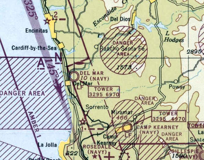
California: Northern San Diego area
© 2002, © 2023 by Paul Freeman. Revised 9/6/23.
This site covers airfields in all 50 states: Click here for the site's main menu.
____________________________________________________
Please consider a financial contribution to support the continued growth & operation of this site.
For the 6th year, the CA pages of this website are sponsored by the California Pilots Association:
Carlsbad Airport (revised 8/5/19) - Camp Pendleton Highway Airstrip (revised 8/29/07) - Camp Pendleton Strip #2 (revised 2/22/14)
Dutch Flats Airport / Ryan Airport / Mahoney Airport / Speer Airport (revised 9/6/23) - Engle Airport / Engel Field / Escondido Airport (revised 9/6/23)
Gillies Airport (revised 8/18/17) - Hi Hi Sky Ranch Airfield (revised 9/6/23) – Linda Vista Mesa Field / Hourglass Field / Miramar NOLF (revised 8/10/17)
McCormick Airfield (revised 7/2/19) - Red Beach Marine Corps Airfield (revised 1/9/22)
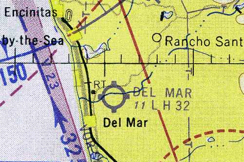
San Dieguito Field / Del Mar NAAF / Del Mar Airport (revised 9/6/23) - San Marcos Valley Airport (revised 8/5/19)
____________________________________________________
Gillies Airport, San Diego, CA
32.775, -117.085 (East of Downtown San Diego, CA)
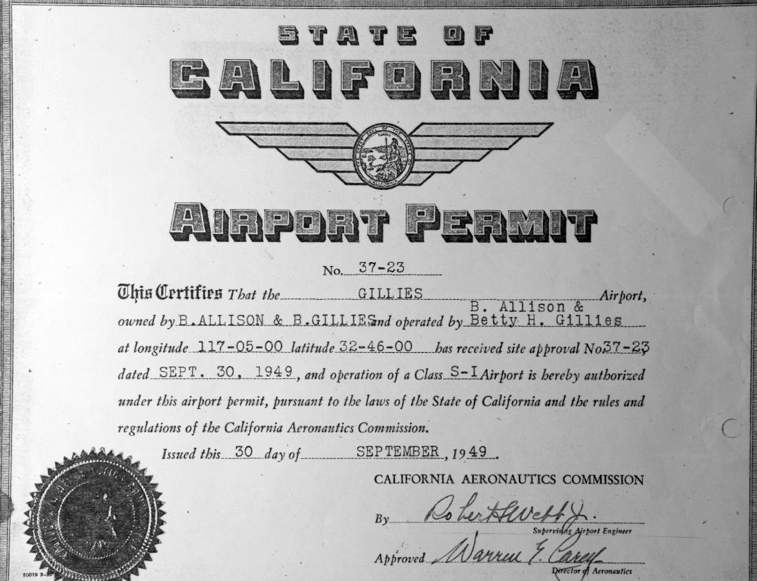
The 9/30/49 State of California Airport Permit for Gillies Airport.
This short-lived general aviation airport was located on top of a mesa to the east of central San Diego.
According to a Mission Valley News article entitled “The neighborhood airstrip that time nearly forgot” by Tom Leech (courtesy of Michael Crisafulli),
“With the end of the war, [Bud & Betty] Gillies arrived in San Diego & made an offer to the Jehovah’s Witnesses for that puzzling piece of land on the mesa.
After more legal finagling, the Gillies got the land. Residential development began in 1948 on an adjoining section of that mesa.
Lots were for sale north of the airstrip, according to a history of Alvarado Estates. They went for $5,000.
Marketing materials noted that you could fly in & out with your own plane, then taxi it over to your own lot & house.
How many new developments could offer that benefit?
The state of California issued an airport permit, dated 9/30/49, authorizing the Gillies to construct & operate a Class S-I Airport on their new land.”
However, Gillies Airport was not depicted on the 1949/50/51 San Diego Sectional Charts or the 1950 USGS topo map.
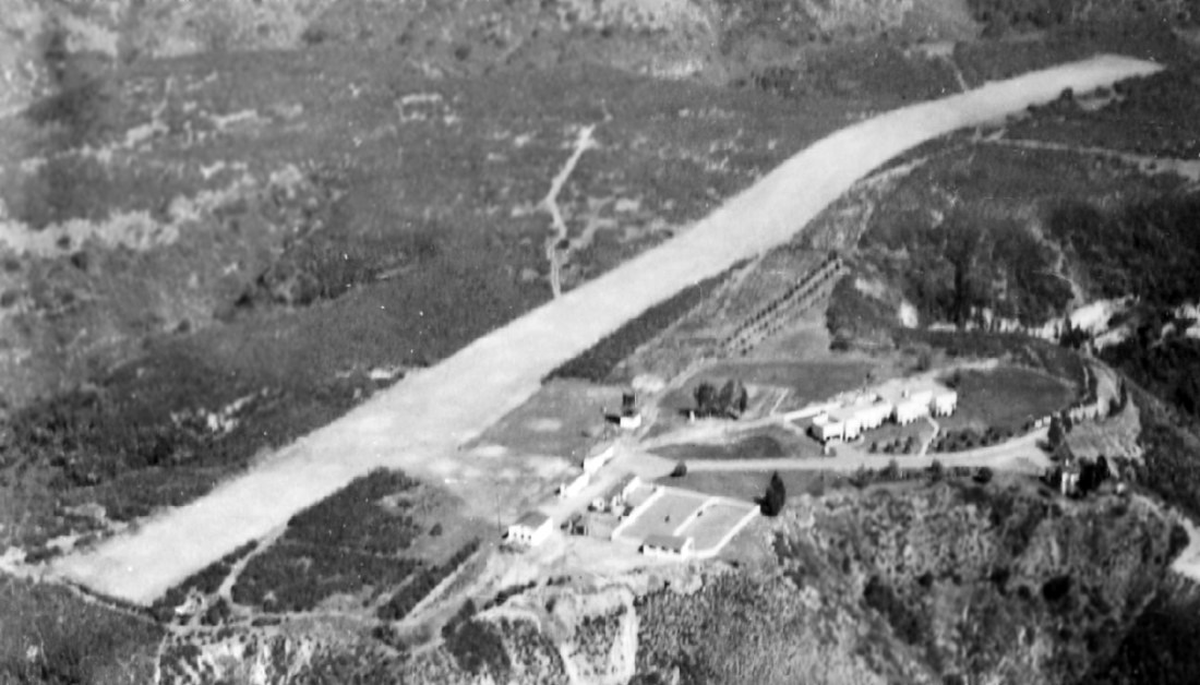
A circa late 1940s – early 1950s aerial view of Gillies Airport, showing the hilly runway on top of the mesa.
Greg Lambron recalled, “I would often see the small planes, such as Cessnas, flying in & out.
The Gillies lived in the house that had been the Jehovah’s Witnesses compound.”
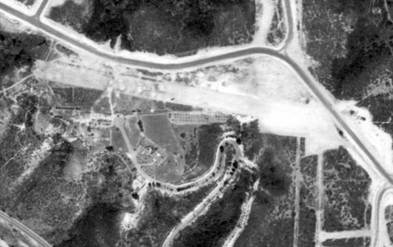
A 1/2/53 aerial view (from the UCSB Library) showed the remains of the Gillies Airport runway, but new roads for the Alvarado Estates development covered the site.
Thus the airport lasted no more than a mere 4 years.
According to a Mission Valley News article entitled “The neighborhood airstrip that time nearly forgot” by Tom Leech (courtesy of Michael Crisafulli),
“On that same space, another set of lots was set up, thus replacing the planes with luxury housing.”
A 1964 aerial view no longer showed any trace of the Gillies Airport runway.
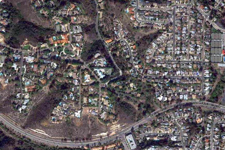
A 2013 aerial view shows houses covering the site of Gillies Airport.
The site of Gillies Airport is located north of the intersection of La Barron Road & Avion Way (the name of which is perhaps the only remaining trace of this little airport).
Thanks to Michael Crisafulli for pointing out this airfield.
____________________________________________________
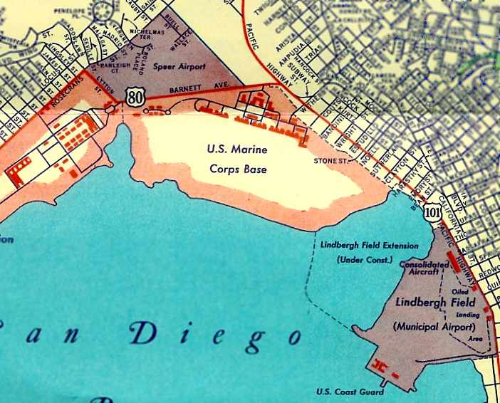
Dutch Flats Airport / Ryan Airport / Mahoney Airport / Speer Airport, San Diego, CA
32.745, -117.205 (North of San Diego Lindbergh Field, CA)
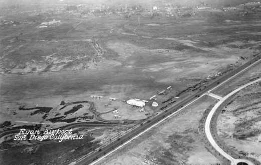
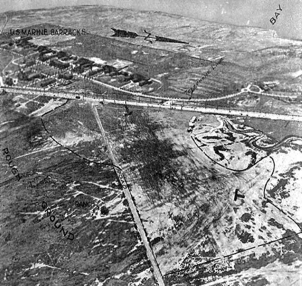
A November 1926 aerial view looking northeast at “Ryan Airport” (Dutch Flats).
This airport was established by the founder of Ryan Aircraft, Claude Ryan.
According to the AIAA report “Historic Aerospace Site: Dutch Flats Airport”:
“As business expanded, Ryan found a new location on a salt flat called Dutch Flats, adjacent to the Marine Corps Recruit Depot.
In the spring of 1923, he moved his operations there & paid a $15 per month rental fee.
He managed to build a hangar & a small office building.
The new location on the corner of Tide Street (later renamed Barnett Avenue)
and Midway Drive (a dirt path at the time) provided a boom to business.
He offered free plane parking to other pilots & increased his business by hiring a full-time mechanic.
His sightseeing business also expanded, and he & his mechanic, Hawley Bowlus,
experimented with increasing the size of airplanes to accommodate more passengers.
He took on a partner, B. Franklin Mahoney, and on 3/1/25,
they debuted the first year-round, regularly-scheduled passenger airline, the Los Angeles - San Diego Air Line.
It continued for about a year & a half.
By 1925, Ryan was becoming more interested in manufacturing his own planes.
His first, the Ryan M-1 (M for monoplane, 1 for first in a series),
was an externally-braced, open-cockpit, high-wing plane, with a 36' span.
With orders coming in at a rapid rate for the M-1,
Ryan leased an old fish cannery about 2.5 miles south of Dutch Flats to build his mail plane.”
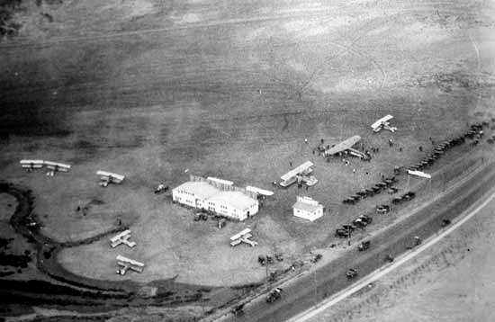
A closeup from the November 1926 aerial view looking northeast at Dutch Flats, showing a few small hangars, 8 biplanes, and one larger monoplane.
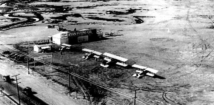
A 1926 aerial view looking northwest at Dutch Flats Airport, showing the buildings of the Ryan Flying Company & 5 biplanes.
A 1926 aerial view looking west at Dutch Flats Airport, showing a Ryan Cloudster & several Standards (courtesy of Kevin Walsh).
According to the AIAA report “Historic Aerospace Site: Dutch Flats Airport”:
“Ryan had begun work on an M-2, but by the end of 1926,
his partnership with Frank Mahoney was dissolved, with Mahoney keeping Ryan Airlines.”
Ryan received a telegram in February 1927 asking if his little company could build a plane capable of a transatlantic flight.
According to the AIAA report “Historic Aerospace Site: Dutch Flats Airport”:
“Miraculously, the Spirit of St. Louis, named for the city of its investors, was built in 60 days.”
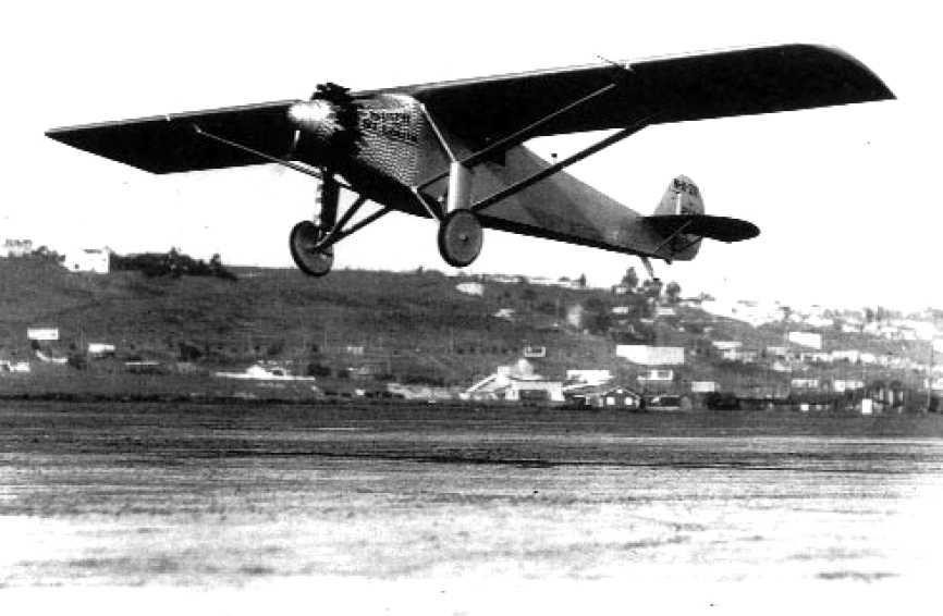
A 4/28/27 photo of the historic first flight of the Spirit of St. Louis, from Dutch Flats Airport.
According to the AIAA report “Historic Aerospace Site: Dutch Flats Airport”:
“On 4/28/27, Lindbergh made the first flight from Dutch Flats Airport.
Essentially all of the employees that built the Spirit came to the field to witness this historic flight.”
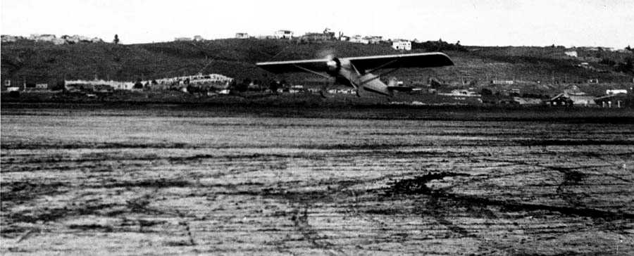
A wider 4/28/27 photo of the first flight of the Spirit of St. Louis, from Dutch Flats Airport.
At some point in 1927, B.F. Mahoney apparently attempted to capitalize on the association of the property as Lindbergh's starting point,
and renamed the field “Mahoney Airport”.
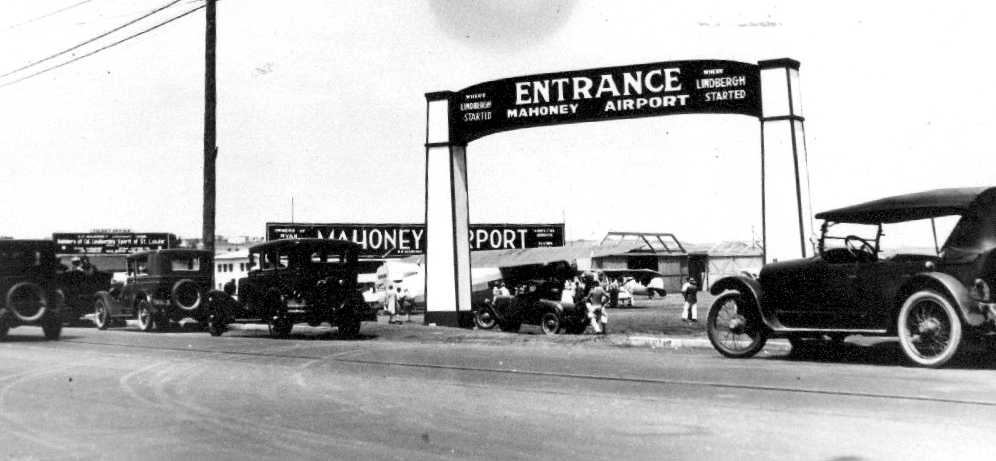
A 1927 photo of an entrance sign at “Mahoney Airport, Where Lindbergh Started.”
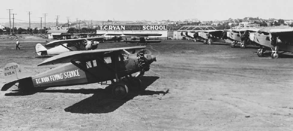
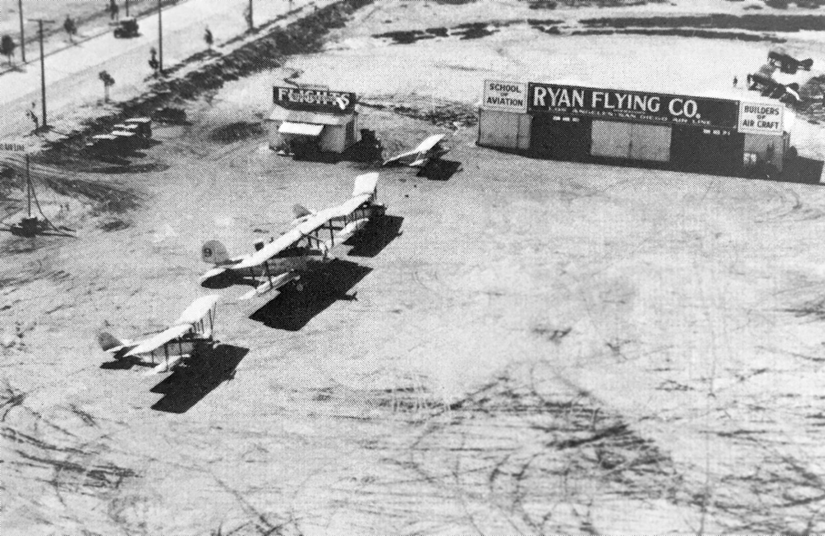
A circa 1928 photo of the T.C. Ryan Flying School at Dutch Flats Airport, showing a total of 11 monoplanes & biplanes of undetermined types.
An undated aerial view looking south at “B.F. Mahoney Airport” from the 1929 Richfield Oil Company Directory of CA Airfields (courtesy of Jonathan Westerling).
The directory described Mahoney as a commercial airport, located at 3200 Barnett Avenue, “directly opposite Marine Barracks.”
The field was said to have a 2,500' northwest/southeast runway & a 1,400' northeast/southwest runway.
The manager was listed as J.J. Harrigan, and the field was said to be the terminus for Maddux Air Lines & Pickwick Airways.
The earliest map depiction which has been located of Ryan Airport was on a 1930 street map (courtesy of Kevin Walsh).
An 11/29/31 photo of an unidentified man & Claude Ryan in front of the state of Lindbergh & the Ryan Flying School hangar at Dutch Flats Airport, for appears to be a delivery of a Ryan Brougham.
According to the AIAA report “Historic Aerospace Site: Dutch Flats Airport”:
“Several years prior to World War II, the name of the Dutch Flats Airport was changed to the Speers Airport.”
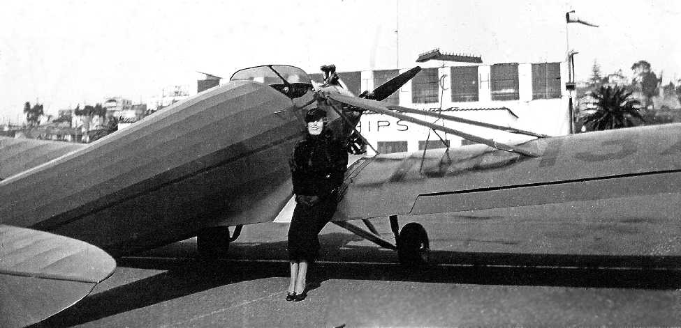
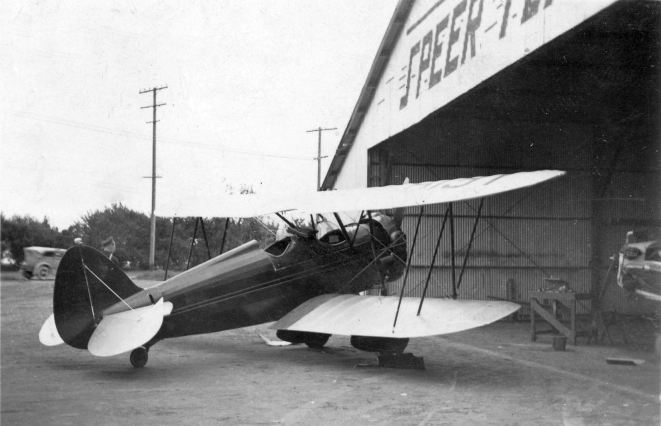
A 1933 photo of Evelyn Speer sitting on a Kinner low-wing monoplane, likely taken at Speer Airport (courtesy of Joanne Lillevold).
Joanne reported, “I am related to Arnet’s Speer’s first wife, Evelyn.”
Speer Airport was not yet depicted on the February 1934 San Diego Sectional Chart.
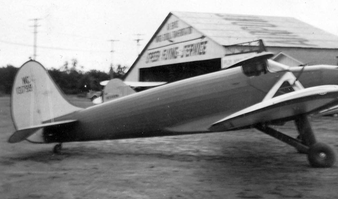
A circa 1935 photo by Steve Magdich of a Kinner low-wing monoplane in front of the hangar marked “Speer Flying Service” (courtesy of Lon Magdich, whose father flew out of Speer Airport circa 1935).
A circa 1935 photo by Steve Magdich of a Waco biplane in front of the hangar marked “Speer Flying Service” (courtesy of Lon Magdich, whose father flew out of Speer Airport circa 1935).
Speer Airport was not yet depicted on the January 1937 San Diego Sectional Chart.
The earliest aeronautical chart depiction which has been located of Speer Airport was on the August 1937 San Diego Sectional Chart,
which depicted Speer as a commercial/municipal airport.
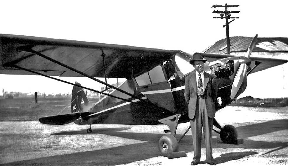
A 1939 photo of Arnet Speer in front of a Piper or Aeronca high-wing monoplane, likely taken at Speer Airport (courtesy of Joanne Lillevold).
Speer Airport, as depicted on a 1939 street map.
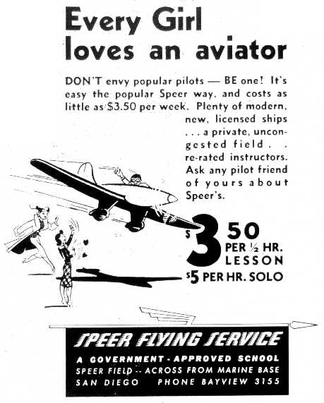
A circa late 1930s – early 1940s advertisement for the Speer Flying Service proclaimed “Every girl loves an aviator.”
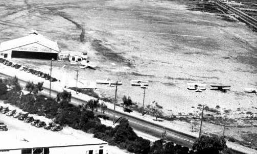
A circa late 1930s – early 1940s aerial view looking northwest at Speer Airport, showing the hangar marked with “Speer Flying Service”,
a control tower, 3 biplanes, and 3 monoplanes.
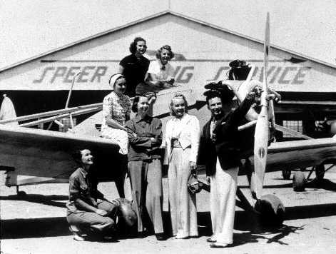
A circa late 1930s – early 1940s photo of an unidentified group in front of an unidentified low-wing monoplane,
with the Speer Flying Service hangar in the background.
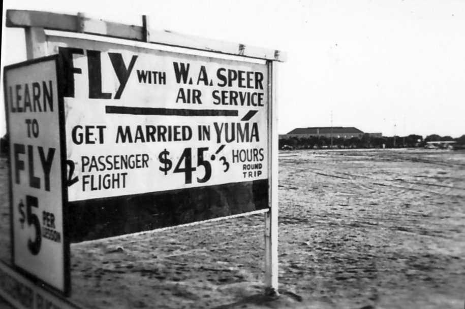
A circa 1940 photo by Frederick Crowther (courtesy of Rick Edgil) of a sign for W.A. Speer Air Service, touting a 3-hour round-trip flight to get married across the state line in Yuma AZ.
What appears to be a single-engine aircraft is visible on the right.
The last aeronautical chart depiction which has been located of Speer Airport was on the October 1942 San Diego Sectional Chart,
which depicted Speer as a commercial/municipal airport.
According to the AIAA report “Historic Aerospace Site: Dutch Flats Airport”:
“The airport was inoperative during WWII, and the government converted the land to military housing facilities.”
Speer Airport was no longer depicted on the August 1943 San Diego Sectional Chart (courtesy of Ron Plante).
According to the AIAA report “Historic Aerospace Site: Dutch Flats Airport”:
“Early in 1970, the government made plans to construct a San Diego Post Office on the corner of Barnett Avenue & Midway Drive.
The post office was opened for business in March 1972, and continues to operate there today.”
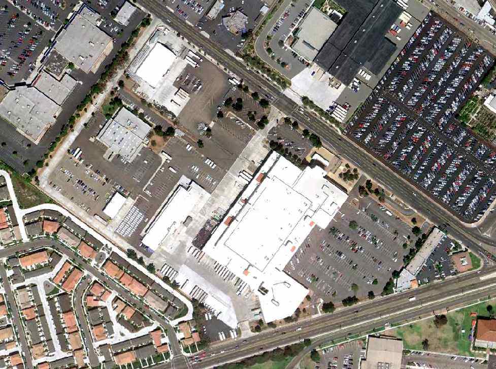
As seen in an 8/24/10 aerial view, no trace remains of the former Dutch Flats Airport.
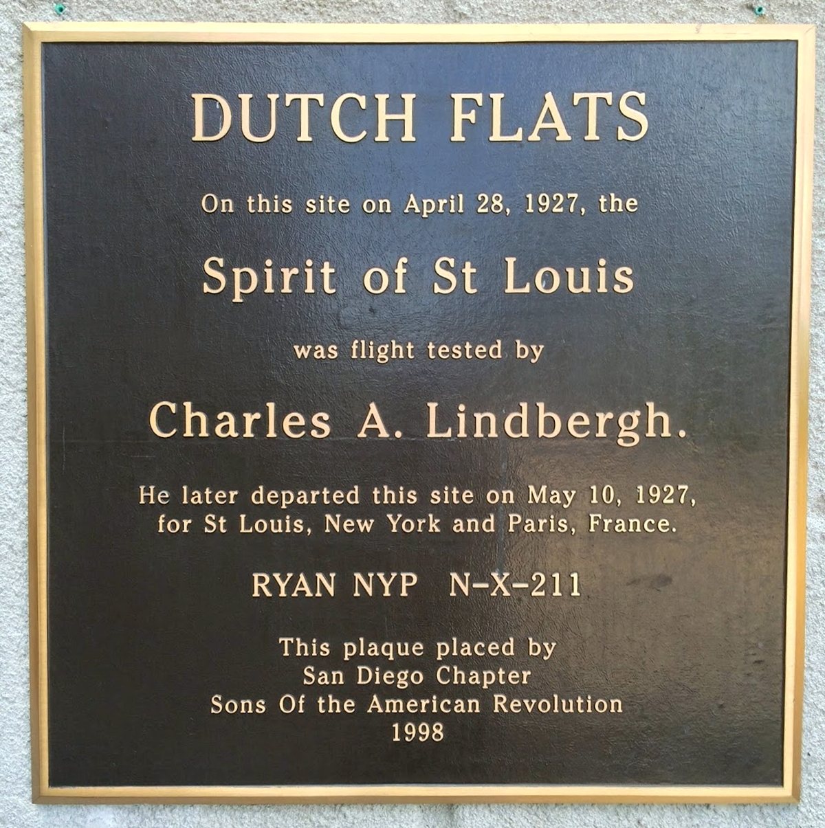
A 2017 (or earlier) photo by Dottie Norkus of a 1998 plaque commemorating the site of Dutch Flats Airport.
Dottie Norkus reported in 2017 of the building on the site of Dutch Flats Airport,
“The post office there has been closed since at least 2013 & the USPS has been trying to find a buyer.”
____________________________________________________
Carlsbad Airport, Carlsbad, CA
33.165, -117.319 (Northwest of San Diego, CA)
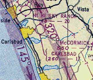
Carlsbad Airport, as depicted on the March 1951 San Diego USAF Sectional Chart (courtesy of Chris Kennedy).
This short-lived little general aviation airport is not to be confused with the present-day Palomar Airport,
which is located a few miles to the southeast.
Carlsbad Airport was evidently established at some point between 1949-51,
as it was not yet depicted on a 1947 aerial photo
nor on the March 1949 San Diego Sectional Chart (according to Chris Kennedy).
The earliest depiction of Carlsbad Airport which has been located
was on the March 1951 San Diego USAF Sectional Chart (courtesy of Chris Kennedy).
It described Carlsbad Airport as having a 1,700' unpaved runway.
According to Rich Kurner, “Tom Bordan founded & ran this airport.”
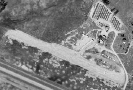
The earliest photo which had been located of Carlsbad Airport was a 1953 aerial view.
It depicted the field as having a single unpaved northwest/southeast runway,
with 4 single-engine aircraft parked around a hangar on the west side.
The 1955 San Diego Sectional Chart (courtesy of John Voss)
described Carlsbad Airport as having a single 1,700' bare runway.
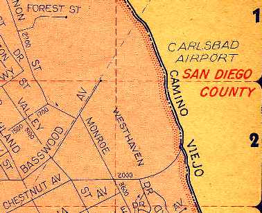
A 1956 street map (courtesy of Chris Kennedy) depicted "Carlsbad Airport" as being located on the east side of Camino Viejo,
north of its intersection with Chestnut Avenue.
No runways or other details were depicted, though.
Rich Kurner recalled, “I can remember as a child watching planes in the late 1950s through the early 1960s.
I flew out of this airport with my father & a friend in his Piper Apache.
There were 2 or 3 hangars, one large enough to house 6 or 7 aircraft.
I watched while Cline Kantareene landed his P-51D Mustang on that short runway,
while Tom Bordan was pushing more dirt onto the runway with his caterpillar, just in case!
A few weeks later, a rich high school student from nearby Army & Navy Academy, ran his father's Grand Commander off the same runway.”
The 1963 AOPA Airport Directory (courtesy of Chris Kennedy)
described Carlsbad as having a single 2,000' oiled Runway 18/36.
The field was said to offer minor repairs, hangars, tiedown, and fuel.
The operator was listed as Forrest Borden.
The directory listing was based on a report from 1961.
Carlsbad Airport, as depicted on the September 1962 San Diego Local Aeronautical Chart (courtesy of Chris Kennedy).
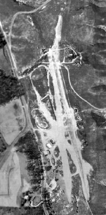
A 1964 aerial photo may have depicted Carlsbad Airport after it had already closed, as no aircraft were visible on the field.
The field had traces of a total of 3 unpaved runways, all oriented predominately northwest/southeast.
A few small buildings (hangars?) were located on the west & east sides of the field.
The last aeronautical chart depiction which has been located of Carlsbad Airport was on the August 1963 San Diego Sectional Chart.
The Carlsbad Airport was apparently closed at some point between 1963-65,
as it was no longer depicted on the August 1965 Sectional Chart (courtesy of Ron Kunse).
It was evidently overtaken by the dense suburban development which was occurring in the area.
According to Rich Kurner, “In 1969 the old 'Tom Bordan' airfield [Carlsbad Airport] was gone.”
A 1980 aerial view showed the site had been covered with houses,
with not a trace remaining of Carlsbad Airport.
Rich Kurner reported in 2009, Carlsbad Airport founder Tom Bordan's “house is still there, on a forgotten corner of that old airport.”
An 11/30/13 aerial view showed the site of Carlsbad Airport is filled with housing,
and not a trace appears to remain of the former airport.
Trisha Drennan reported in 2015, “I am the archaeologist working near the site identified as 'the old Carlsbad Airport'
on a City of Carlsbad El Camino Real street widening project.
A resident to this area told me that the rubble on site was what was left of the airplane hangers at this old landing strip.”
Thanks to Chris Kennedy for pointing out this airfield.
____________________________________________________
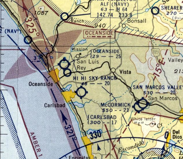
Hi Hi Sky Ranch Airfield, Oceanside, CA
33.197, -117.35 (Northwest of San Diego, CA)
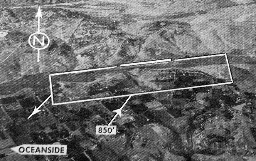
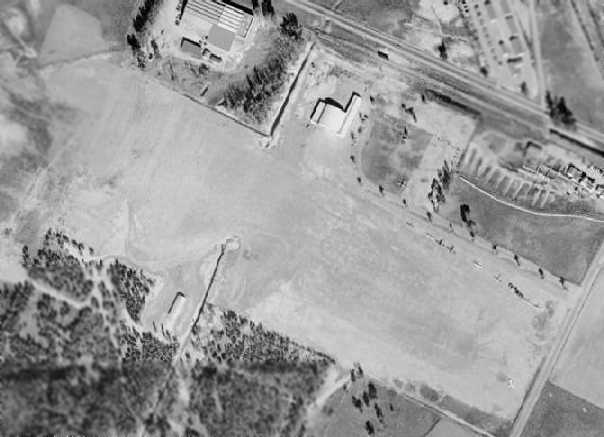
A 1946 aerial view depicted the Hi Hi Sky Ranch as having a single unpaved northeast/southwest runway,
with a hangar on the northwest side.
This little general aviation airport with the funny name was established in 1946,
which was probably the single year in which the most airports were ever established across the U.S.
According to Kenneth W. Nill, "My father, Kenneth A. Nill, started this airport in 1946.
I was 7 years old when the airport started, so I have vivid memories of the goings on around the airport.
That 'funny name' came from the guest ranch for boys adjacent to the airport called the Hi Hi Guest Ranch.
In that era, the term 'Sky Ranch' was commonly used for small airports.”
An article in the 4/2/46 issue of the Oceanside Blade-Tribune (courtesy of Kristi Hawthorne of the Oceanside Historical Society)
was entitled “Hi-Hi Sky Club Members Plan Weekly Trips.”
It read, “The 1st Saturday '“Breakfast Hop' of the Hi-Hi Sky Club,
newly organized flying group at the Hi-Hi Sky ranch, turned out to be a Sunday 'Dinner Hop' last weekend.
Undaunted by the continual showers, 14 members of the club made the aerial trip to the Puente Skyranch,
20 miles east of Los Angeles, and have already decided to make the hops a weekly affair.
Pilots, learners and persons not desiring to go on the weekly trips may join the Sky club regardless whether they wish to fly,
according to Kenneth A. Nill, manager of the Sky ranch in Loma Alta canyon.
Construction of a new office & hangars for the flying field is to be started this week, according to Nill.
The former B-29 test pilot also announced that a number of students at the field
are well on their way to soloing & others to earning their private licenses.
With a 2,400' runway, the Sky Ranch offers aircraft sales and service, charter flights, and private pilot instruction.”
The earliest depiction which has been located of the Hi Hi Sky Ranch was a 1946 aerial photo.
It depicted the Hi Hi Sky Ranch as having a single unpaved northeast/southwest runway, with a hangar on the northwest side.
A total of 7 light aircraft were visible on the north & south sides of the field.
Hi Hi Sky Ranch was not yet depicted on the August 1946 San Diego Sectional Chart.
An article in the 1/10/47 issue of the Oceanside Blade-Tribune (courtesy of Kristi Hawthorne of the Oceanside Historical Society)
was entitled “Hi-Hi Sky News.”
It read, “Improvements are continuing to be made at the Hi Hi Sky Ranch,
this past week being the raising of the gasoline pump to the level of the runway & the painting of the office both inside & out.
Dick Litle & Lauran Laverty soloed this past week.
Elmer Pitts of Oceanside & Capt. Ray Wall of Camp Pendleton passed their private tests, this giving them their private licenses.
The Sky Ranch is becoming a very popular stop lately for fliers from other airports.
Many have used this field as one of their stops on their cross-country flights
from San Diego, Los Angeles, and Orange county training schools.”
The earliest aeronautical chart depiction of Hi Hi Sky Ranch which has been located was on the February 1947 San Diego Sectional Chart.
It depicted "Hi Hi Sky Ranch" as a commercial/municipal airport.
The 1948 San Diego Sectional Chart (courtesy of Chris Kennedy) depicted "Hi Hi Sky Ranch" as having a 1,800' unpaved runway.
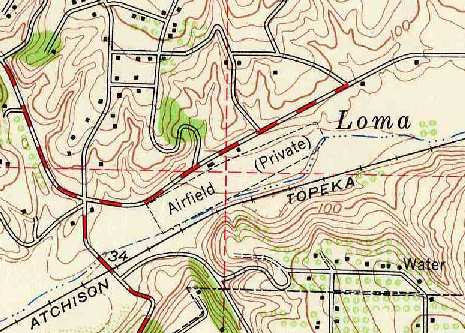
The 1948 USGS topo map (courtesy of Chris Kennedy) labeled Hi Hi Sky Ranch simply as "Airfield (Private)",
and depicted it as having a single 2,000' northeast/southwest runway.
Two small buildings (hangars?) were depicted along the north side of the runway.
The airfield was squeezed into a narrow piece of property bounded by Oceanside Boulevard on the north & the Atchinson, Topeka, and Santa Fe Railroad on the south.
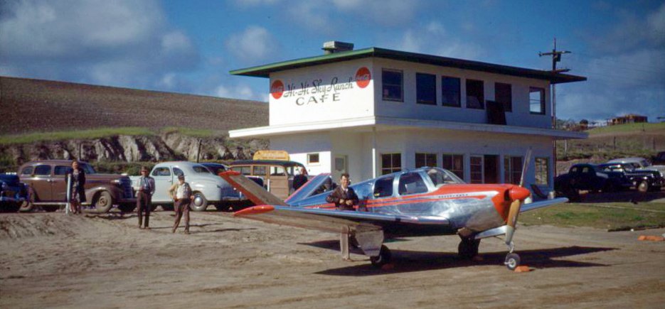
A 1948 photo of a beautiful natural aluminum Beechcraft Bonanza in front of the distinctive Hi Hi Sky Ranch Cafe (courtesy of Michael Gorth).
An undated aerial view looking north at Hi Hi Sky Ranch from the 1950 Air Photo Guide (courtesy of Kevin Walsh).
The guide described Hi Hi Sky Ranch as having a 2,000' Runway 6/24, and listed the manager as Kenneth Nill.
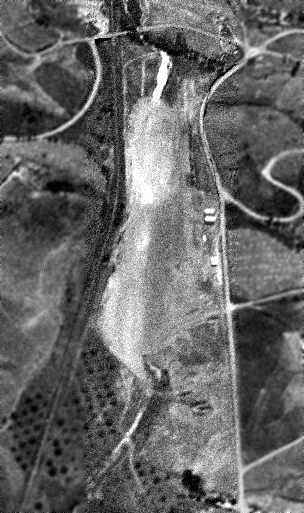
A 1950 aerial view looking southwest along the single unpaved runway of the the Hi Hi Sky Ranch Airport (courtesy of Ken Nill).
Ken observed, “The 2 airplane hangars are along the right side of the white runway.
The Hi Hi Guest Ranch is below the runway near the bottom edge of the picture.”
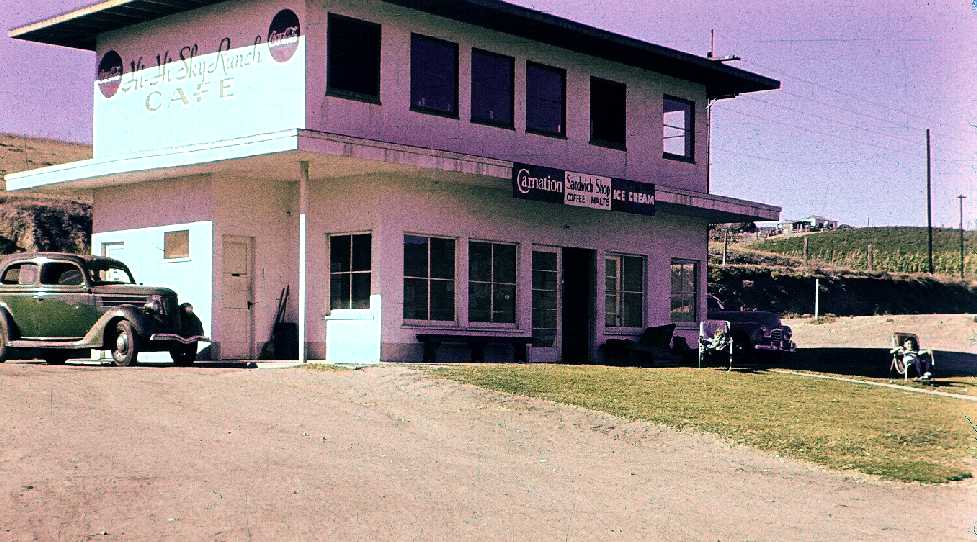
A 1951 or 1952 photo by Vincent Hague of the Hi Hi Sky Ranch Cafe (courtesy of Donna Hague Wendt, whose father was a private pilot & Civil Air Patrol member).
A 1953 USGS aerial photo showed 3 single-engine aircraft next to the runway.
According to Kenneth Nill, his father "closed it down about 1953 when he started the industrial development that now covers the area."
The closing date of the Hi Hi Sky Ranch may have been somewhat later than 1953,
as it was still depicted as an active airport on the March 1955 Diego Sectional Chart (courtesy of John Voss).
The Aerodromes table described the field as having a single 2,000' oiled runway which was "Closed to the public."
The Hi Hi Sky Ranch Airfield was evidently closed by 1955,
as it was no longer depicted on the September 1955 San Diego Sectional Chart (according to Chris Kennedy).
An article in the 8/31/58 issue of the Oceanside Blade-Tribune (courtesy of Kristi Hawthorne of the Oceanside Historical Society)
noted “Carl Cook has asked for a conditional use permit
to operate a trailer park on property known as the 'Hi-Hi Guest Ranch for Boys.'”
A 1964 aerial view showed that several buildings had been built over the eastern & western portions of the former airfield,
but the hangars still remained standing on the north side of the former runway.
The 1966 USGS topo map continued to depicted an "Airfield (Private)",
even though the airfield had ceased to exist by several years by that point.
The 1969 USGS topo map depicted a large building having been constructed over the southwest runway end.
By the time of a 1980 aerial view, the former hangars were gone, with no trace remaining of the former airport.
According to Kenneth Nill, "The last bit of the original airport property owned by my family was sold in 2003."
An 11/12/13 aerial photo showed no trace remaining of Hi Hi Sky Ranch.
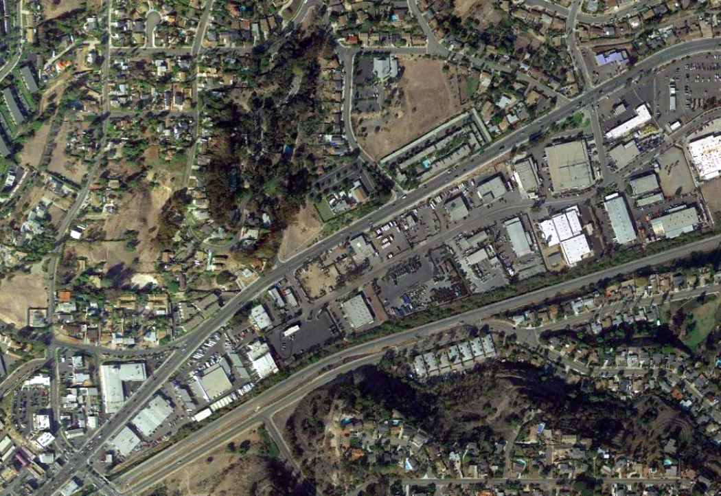
The site of the Hi Hi Sky Ranch Airfield is located south of the intersection of Oceanside Boulevard & Industry Street.
Thanks to Chris Kennedy for pointing out this airfield.
____________________________________________________
Engle Airport / Engel Field / Escondido Airport, Escondido, CA
33.122, -117.105 (North of San Diego, CA)
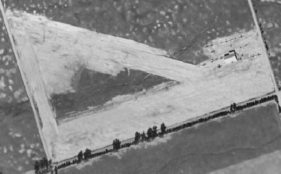
A 1947 aerial view depicted the Engle Airport as having a single unpaved northwest/southeast runway,
with one hangar each on the north & south sides of the runway.
This rather obscure little airport evidently was opened at some point during 1946,
as it was not listed among active airfields in the 1945 AAF Airfield Directory (courtesy of Scott Murdock)
nor depicted on the 1946 San Diego Sectional Chart (according to Chris Kennedy).
The earliest reference to the Escondido Airport which has been located
was in the June 1946 Airman's Guide (according to Chris Kennedy).
Chris observed, “It's listed out of order at the end of the column, which would indicate that it was new then.”
The January 1947 Airman's Guide (according to Chris Kennedy) listed it as “Engle (Escondido)”.
The earliest depiction of Engle Airport which has been located was a 1947 aerial photo.
It depicted Engle as having a single unpaved northwest/southeast runway,
with one hangar each on the north & south sides of the runway.
A total of a 7 light aircraft were visible parked on the northeast side of the runway.
Sheila Stone reported, “My father [James Lissey] worked at Engel Aircraft Specialties in 1947”, as documented by a W-2 statement.
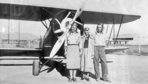
A circa 1947 photo of 2 women & a man in front of an unidentified biplane at Engel Field, with a hangar visible in the right background.
The 1948 USGS topo map (courtesy of Chris Kennedy)
depicted the “Engle Airport (private)” as having a single northwest/southeast runway,
with a single hangar each on the south & north sides of the runway.
The Engle/Escondido Airport still was not depicted at all on the March 1949 San Diego Sectional Chart (according to Chris Kennedy).
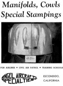
A 1949 advertisement for “Engel Aircraft Specialties” of Escondido, which provided “Manifolds, cowls, and special stampings for airlines, Civil Air Patrol, and training schools”.
The earliest aeronautical chart depiction which has been located of the Escondido Airport
was on the March 1951 San Diego Sectional Chart (courtesy of Chris Kennedy).
It depicted Escondido as a public-use airfield having a 1,900' unpaved runway.
The Escondido Airport was still depicted as an open field
on the March 1952 San Diego Sectional Chart (according to Chris Kennedy).
The last photo which has been located showing the Engle Airport still in operation was a 3/31/53 USGS aerial view.
The unpaved northwest/southeast runway remained clear but no longer distinctly maintained.
The hangars on the north & south sides remained intact, but did not appear to be still in use.
However, 1 light single-engine aircraft remained visible on the southeast corner of the field.
The Escondido Airport evidently closed (for reasons unknown) at some point in 1953,
as it was listed as closed in the 1953 Aviation Week Airport Directory (courtesy of David Brooks).
The last aeronautical chart depiction which has been located of the Escondido Airport
was on the September 1954 San Diego Sectional Chart (courtesy of Chris Kennedy).
However, the chart's Aerodromes table described the field as closed.
Escondido Airport was no longer depicted on the March 1955 San Diego Sectional Chart.
Escondido Airport, as depicted on a 1957 street map (courtesy of Kevin Walsh).
A 1964 aerial view showed that the hangar still remained standing on the north side of the field,
although the hangar on the south side had evidently been removed at some point between 1948-64.
Several buildings had also been built along the eastern end of the runway,
but the majority of the former runway was still clear.
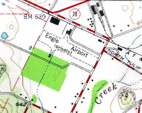
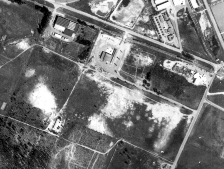
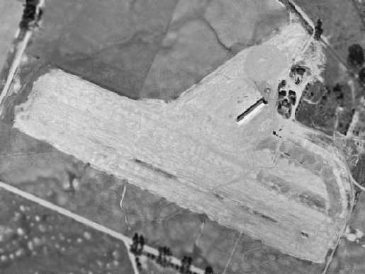
The runway layout of the former Engle Airport, as annotated by Chris Kennedy over a 2006 aerial view of the site.
The site has become heavily redeveloped, with numerous industrial buildings replacing any trace of the former runway.
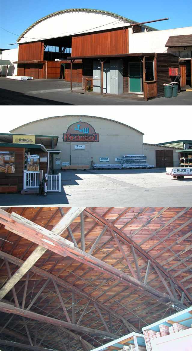
A series of October 2006 photos by Chris Kennedy of the former hangar which remains on the north side of the site of the former Engle Airport.
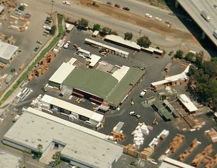
Chris observed, “The hangar is now used as a lumber warehouse by J & W Redwood.”
A circa 2006 aerial view looking north at the former Engle Airport hangar.
Sheila Stone reported in 2019, “I visited the J&W Lumber site & went into the hangar & it is fascinating.”
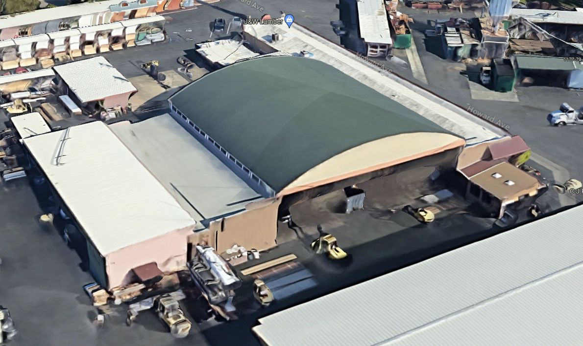
A 2023 3-D aerial image looking northeast at the former Engle Airport hangar, reused by J&W Lumber.
The site of the Engle Airport is located southwest of the intersection of Interstate 15 & West Washington Avenue.
____________________________________________________
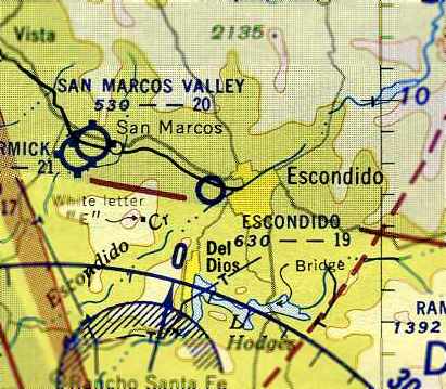
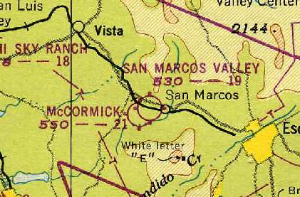
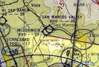
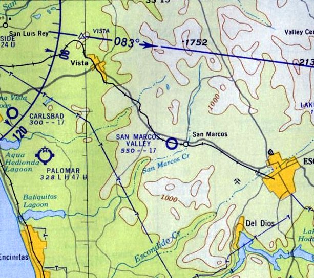
San Marcos Valley Airport, San Marcos, CA
33.142, -117.182 (North of San Diego, CA)
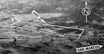
A 1947 aerial view depicted the San Marcos Valley Airport as having 2 unpaved runways,
with a hangar east of the runway intersection.
San Marcos Valley Airport was evidently opened at some point between 1946-47,
as it was not listed among active airfields in the 1945 AAF Airfield Directory (courtesy of Scott Murdock)
nor depicted on the February 1946 San Diego Sectional Chart (according to Chris Kennedy).
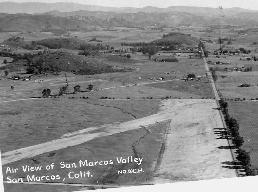
The earliest depiction which has been located of the San Marcos Valley Airport was a 1947 aerial view.
It depicted the field as having 2 unpaved runways, with a hangar east of the runway intersection.
What appeared to be 2 light aircraft were visible on the east side of the field.
The earliest aeronautical chart depiction which has been located of the San Marcos Valley Airport
was on the 1948 San Diego Sectional Chart (courtesy of Chris Kennedy).
It depicted San Marcos Valley Airport as having a 1,900' unpaved runway.
It also depicted the adjacent McCormick Airfield.
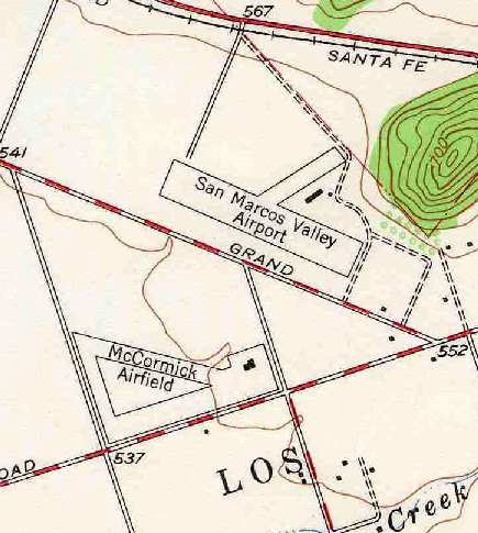
The 1948 USGS topo map (courtesy of Chris Kennedy)
depicted San Marcos Valley Airport as having a 2,000' northwest/southeast runway,
along with a shorter northeast/southwest strip.
A single building (a hangar?) was depicted just east of the runway intersection.
Another small airport, McCormick Airfield, was depicted right across the street,
on the south side of Grand Avenue.
An undated aerial view looking north from the 1950 Air Photo Guide (courtesy of Kevin Walsh)
depicted San Marcos Valley Airport as having a 2,000' dirt Runway 9/27.
The manager was listed as Lee Garner.
The Aerodromes table on the 1955 San Diego Sectional Aeronautical Chart (courtesy of John Voss)
described San Marcos Valley Airport as having a single 2,000' bare runway.
San Marcos Valley Airport was described in the 1962 AOPA Airport Directory as having a single 2,000' bare Runway 13/31,
and the operator was listed as Lee Garner.
The 1962 San Diego Local Aeronautical Chart (courtesy of Chris Kennedy) gave a somewhat different runway configuration for San Marcos Valley Airport,
with 2 runways, with the longest being a 1,900' strip.
The last depiction which has been located of the San Marcos Valley Airport was a 1964 aerial view.
It showed that the former crosswind runway had been abandoned, with buildings having been erected on the northeast side of the former runway.
The airfield configuration was reduced to a single unpaved northwest/southeast runway.
Several new T-hangars had been added at some point between 1947-64.
The field showed an increase in activity compared to the 1947 photo,
as a total of 7 light aircraft were visible on the field, including one on the runway.
Some of these aircraft may have come from the former airfield across the street, the McCormick Airfield,
which had evidently closed in the previous few years.
The San Marcos Valley Airport was apparently closed at some point between 1964-65,
as it was no longer depicted on the August 1965 Sectional Chart (courtesy of Ron Kunse).
The cause of the airport's apparent demise was evident on the 1979 USGS topo map,
which depicted that the 78 Freeway had been built through the site of the former airport by that time.
The 1994 USGS aerial photo of the site did not show any remaining trace of the former airport.
The property had been redeveloped with numerous large buildings.
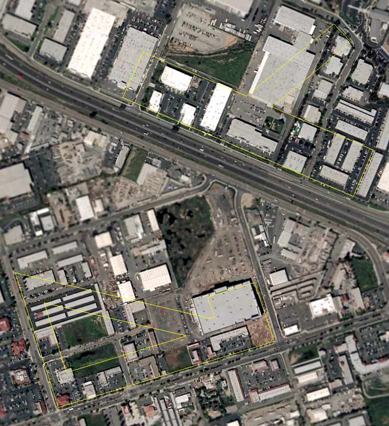
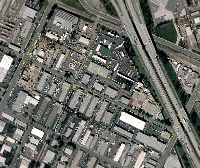
A 2006 aerial photo annotated by Chris Kennedy to show the runway layout of the San Marcos Valley Airport (as well as the former McCormick Airport located just to the south).
Not a trace remains of either field.
The site of San Marcos Valley Airport is located north of the intersection of West San Marcos Avenue & the 78 Freeway.
Thanks to Chris Kennedy for pointing out this airfield.
____________________________________________________
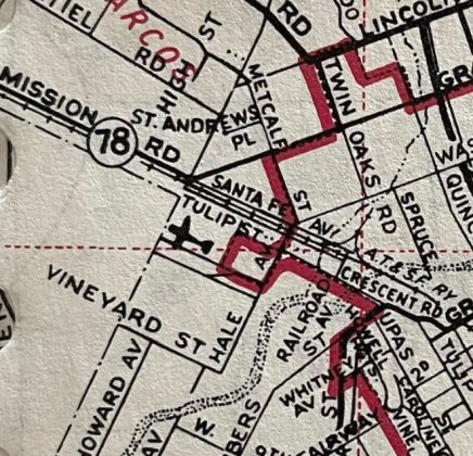
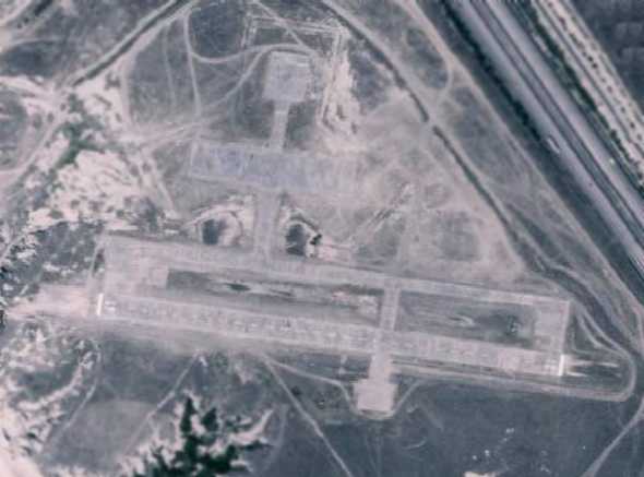
McCormick Airfield, San Marcos, CA
33.137, -117.187 (North of San Diego, CA)
A 1947 aerial view depicted the McCormick Airfield as having 3 unpaved runways,
with a hangar on the east side of the field.
According to an article entitled “McCormick Field was family operation” by Vincent Rossi in the 4/30/06 San Diego UT (courtesy of Randy Dillinger),
“From 1945 the site was occupied by McCormick Field, a privately owned & operated airport that included a flight school, Almand Air Academy.
The airport & school were the dream of George Almand.
Upon his discharge from the Navy in August 1944, Almand, who had run training programs for pilots & mechanics as part of the war effort,
returned to his home in Carlsbad & began looking for land on which to build an airport.
He found what he was looking for at what was then Encinitas & Bent Avenues in San Marcos & purchased 60 acres.
'We purchased it as a family project: myself; my wife, Jane; and her mother, Faith McCormick,'
Almand wrote in a brief history written in 1996 that is now in the archives of the San Marcos Historical Society.
Their application for a permit from the Civil Aeronautics Administration was granted on 11/5/45.
McCormick Field, named in honor of Almand's mother-in-law & partner, opened for business 6 days later.”
The article continued, “In the beginning, the airport consisted of a runway without any buildings,
'a Plymouth coupe as office & maintenance shop' & one war-surplus airplane, Almand wrote.
Gradually, more planes were acquired & a 50' x 90' hangar with an attached 40' square Quonset hut was erected.
Almand Air Academy taught flying, aircraft maintenance & other ground crew functions.
In the years immediately after the war, many students took courses under the GI Bill.
The academy also offered charter flights & provided sales & maintenance services to local & visiting fliers.
Among those who learned to fly at McCormick Field was Almand's stepson, Michael Dewart.
'Our airport was operated kind of like an extended family,' Almand wrote.
'We had some full-time employees, some part-time employees & quite a lot of volunteer people.'”
The article continued, “Almand also founded a flying club, the Palomar District Flyers.
The club was quite active, Almand recalled in his history, with 'lots of breakfast hops, some overnight flights,
some camp-out flights, like parking on a dry lake bed & sleeping under our airplanes.
We went to quite a few fly-in events at other airports. We had at least one potluck in our clubhouse each month.'
The club did a cross-formation flyover each year at local Easter sunrise services & charity work.
Almand recalled that when a local family lost their home in a fire & needed money for burn treatments for one of the children,
the flying club gave airplane rides in exchange for donations to an emergency fund.”
McCormick Airfield was not yet depicted on the February 1946 San Diego Sectional Chart (according to Chris Kennedy).
The earliest depiction which has been located of the McCormick Airfield was a 1947 aerial view.
It depicted the field as having 3 unpaved runways, with a on the east side of the field.
A dozen light aircraft were visible parked on the east side of the field.
The earliest aeronautical chart depiction which has been located of the McCormick Airfield
was on the 1948 San Diego Sectional Chart (courtesy of Chris Kennedy).
It depicted McCormick Airfield as having a 2,100' unpaved runway.
It also depicted the adjacent San Marcos Valley Airport.
The 1948 USGS topo map (courtesy of Chris Kennedy) depicted McCormick Airfield as having a total of 3 runways,
with the longest being 2,000' northwest/southeast runway, along with a shorter northeast/southwest strip.
A ramp with a single building (a hangar?) was depicted on the east side of the field.
Another small airport, San Marcos Valley Airport, was depicted right across the street, on the north side of Grand Avenue.
According to an article entitled “McCormick Field was family operation” by Vincent Rossi in the 4/30/06 San Diego UT (courtesy of Randy Dillinger),
“Over the years, the airport was host to a Civil Air Patrol unit and the San Marcos Sky Divers, a group of Camp Pendleton Marines who came out to sky-dive in their spare time.
Among the pilots who used McCormick Field in the 1950s was TV & movie star Bob Cummings.
Cummings flew an Aerocar, a plane with foldable wings that could also be driven like a car.
'It seemed like a pretty good little machine,' Almand told a local newspaper reporter in 1996.
'He'd fly in, take the wings off & drive around.'
A photograph in the San Marcos Historical Society archives shows Cummings standing in front of the vehicle while Almand filled the gas tank.”
The Aerodromes table on the 1955 San Diego Sectional Aeronautical Chart (courtesy of John Voss)
described McCormick Airfield as having 2 runways, with the longest being a 2,100' bare strip.
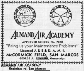
An advertisement for McCormick Field's Almand Air Academy from the 1956 Escondido City & Rural Directory (courtesy of Alexa Clausen).
According to an article entitled “McCormick Field was family operation” by Vincent Rossi in the 4/30/06 San Diego UT (courtesy of Randy Dillinger),
“The opening of Palomar Airport in Carlsbad in 1959 drew business away from McCormick Field.”
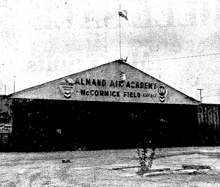
An undated aerial picture looking east at McCormick Airfield (courtesy of Mark Langford).
The hangar visible in the 1947 photo was not present in this photo.
Mark Langford recalled of McCormick Airport, “The song 'Angel Baby' was recorded there in 1960.”
By 1962, the status of McCormick Airport had apparently changed to a private field,
as the 1962 AOPA Airport Directory included the remark, "Private field, prior landing permission required."
McCormick Airport was described as having a single 1,900' dirt Runway 4/22,
and the operator was listed as Paul Spencer.
The last photo which has been located of McCormick Field was an undated photo of the Almand Air Academy hangar from a 10/21/62 article (courtesy of Alexa Clausen).
It was captioned, “Weeds grow among blown down signs in front of hangar at deserted McCormick Field near San Marcos. Land is now being subdivided, sold.”
The article was entitled, “San Marcos era ends: Land values beat airport; subdividers in command.”
According to an article entitled “McCormick Field was family operation” by Vincent Rossi in the 4/30/06 San Diego UT (courtesy of Randy Dillinger),
“Operations were phased out in the early 1960s. Almand eventually subdivided & sold off the land for development.”
McCormick Airfield was no longer depicted on the 1962 San Diego Local Aeronautical Chart (according to Chris Kennedy).
A 1964 aerial view showed that the airfield remained intact, but the runways were somewhat deteriorated,
and there were no aircraft visible on the property,
According to
Mark Langford, “I lived across the street from McCormick Field
1967-68.
The field was primarily used for model airplanes on
the weekends. The hangar had a lot of activity.
I'm assuming they rented out space, it was a huge metal hangar.
A drag racer, Johnnie Harris, worked on his car in there at night & he'd drag race on Sundays at Carlsbad Raceway.”
The 1994 USGS aerial photo did not show any remaining trace of McCormick Airport,
with the property having been redeveloped with numerous large buildings.
A 2006 aerial photo annotated by Chris Kennedy to show the runway layout of the McCormick Airport (as well as the former San Marcos Valley Airport located just to the north).
Not a trace remains of either field.
The site of McCormick Airfield is located north of the intersection of West San Marcos Avenue & Via Vera Cruz.
____________________________________________________
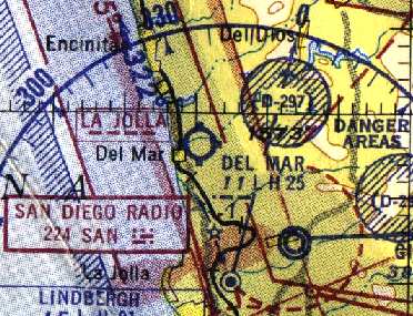
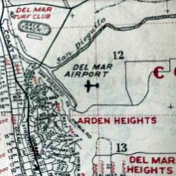
San Dieguito Field / Del Mar Naval Auxiliary Air Facility / Del Mar Airport, Del Mar, CA
32.97, -117.253 (North of San Diego, CA)
The Del Mar Airfield, as depicted on the 1929 U.S. Navy Aviation Map (courtesy of Roger Connor).
This property was first used as an airfield in the 1920s, when the Navy established an emergency landing field known as the San Dieguito Field
(according to the Friends of the San Dieguito River Valley web site).
The earliest depiction which has been located of Del Mar Airfield was an undated aerial view from the 1929 U.S. Navy Aviation Map (courtesy of Roger Connor).
The chart described Del Mar as “Field, very short”.
San Dieguito Field / Del Mar Airport was not yet depicted on the February 1934 San Diego Sectional Chart.
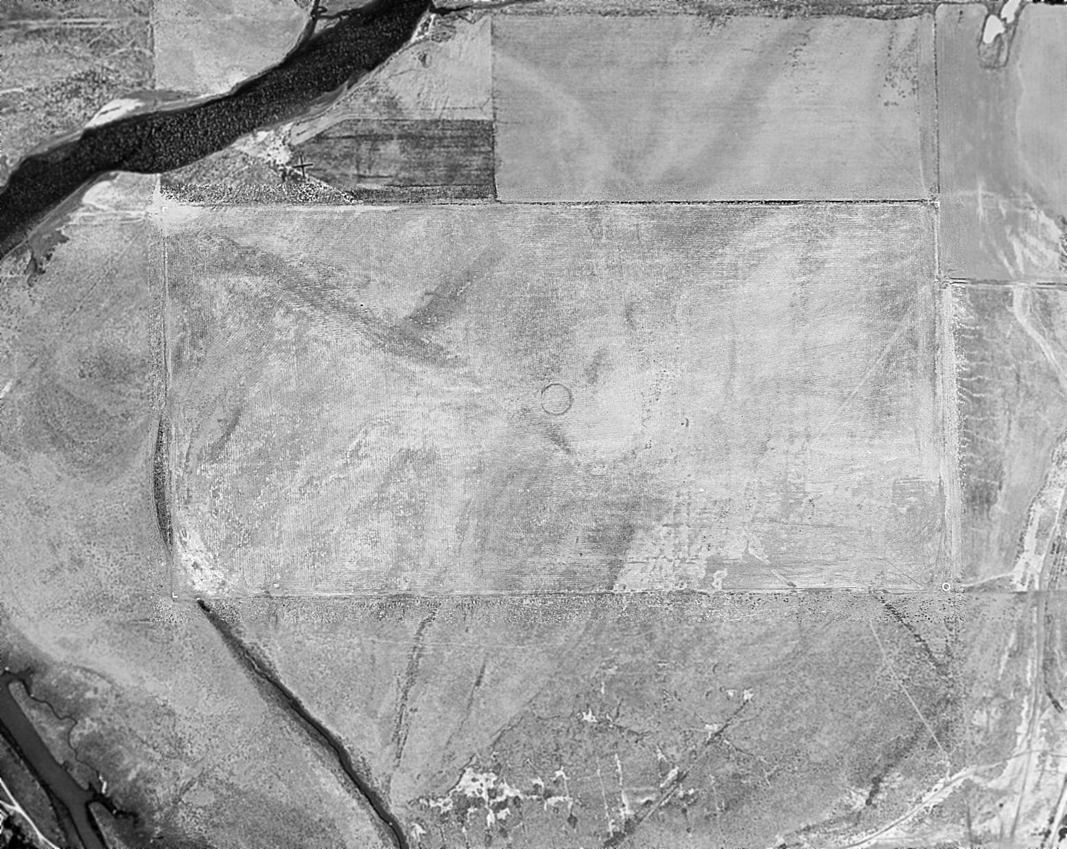
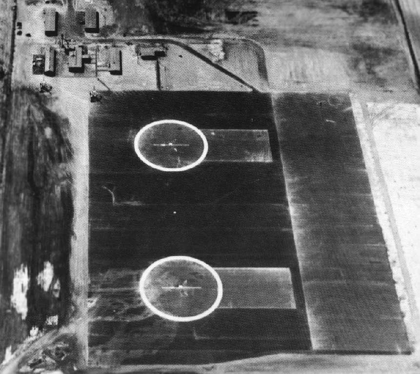
A 6/25/37 aerial view (from the UCSB Library) depicted Del Mar Airport as an unimproved rectangular unpaved airfield with an airfield circle marking in the center,
with no buildings, aircraft, or any other features.
The Del Mar Airfield property was believed to have been developed in 1938 as a municipal airport to serve the racing patrons at the new Del Mar Fairgrounds.
The airport included a 3,500' runway & several support buildings.
A 1/3/41 aerial view (from the UCSB Library) depicted Del Mar Airport in the same fashion as the 1937 photo: an unimproved rectangular unpaved airfield.
In 1941, the Navy purchased 80 acres at the site with the intention of building an improved airfield with 2 paved runways.
However, the planned paved runways were not constructed
as the cost of building a dike to prevent flooding on the site proved prohibitive,
and the facility was eventually used as a blimp base instead.
After Pearl Harbor, fairs & racing at the nearby Del Mar Fairgrounds were suspended,
and the Navy used the fairgrounds & racetrack as barracks, galleys, mess halls, offices, recreational facilities and classrooms
for Navy personnel stationed at the Del Mar airfield during the war.
Del Mar Airport was not yet depicted on the October 1942 San Diego Sectional Chart.
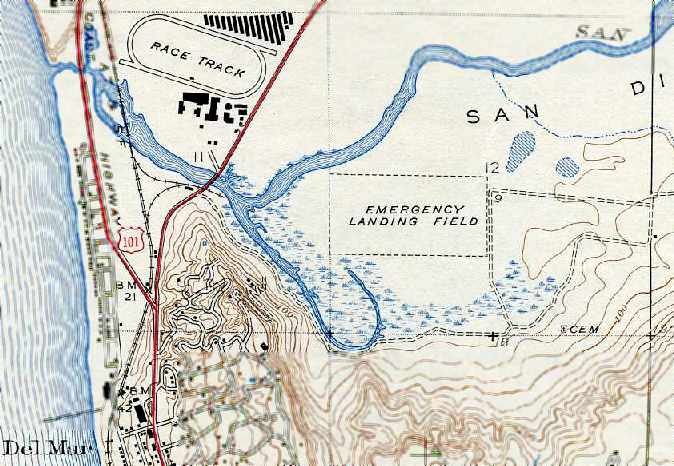
The Del Mar airfield was depicted simply as a rectangular area labeled “Emergency Landing Field” on the 1943 USGS topo map.
Starting in 1943 the US Naval Auxiliary Air Facility Del Mar was used as a base for blimps
which conducted anti-submarine patrols along the west coast.
The airfield consisted of a 1,000' x 500' asphalt blimp landing mat with 2 mooring circles.
Other military construction included 6 buildings & 5 ordnance magazines.
Barracks were provided for a total of 138 personnel.
A 1943 aerial view looking west at Del Mar NAAF (National Archives photo).
Usually only 2 blimps operated from the Del Mar field at one time since there were only 2 mooring masts.
They were refueled at Del Mar & then continued anti-submarine patrols up & down the coast and as much as 100 miles out to sea.
The blimps operated from Del Mar were K-types assigned to the blimp squadron ZP-31 based at the Santa Ana Naval Air Station.
The K-type blimps were 252' in length, able to lift 7,770 pounds, and boasted a maximum speed of 68 knots.
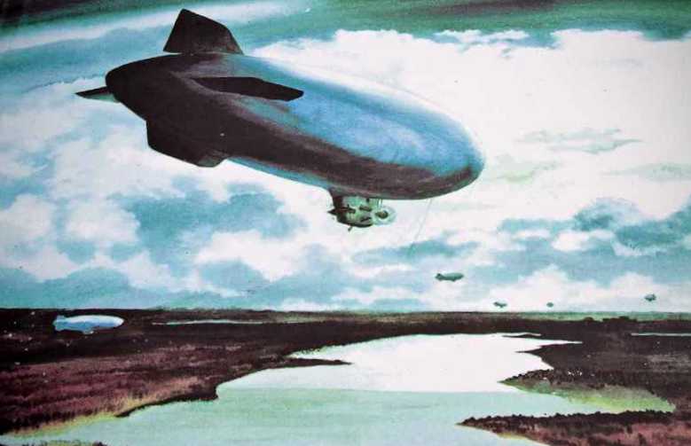
A painting by Adolph Dehn (courtesy of Mark Dossett) of blimps heading out from Del Mar NAAF.
The earliest aeronautical depiction which has been located of NAAF Del Mar was on the March 1944 San Diego Sectional Chart.
It depicted a blimp mooring mast on the airfield.
In 1944, MGM Studios used the blimp base to film portions of the movie "This Man's Navy".
One of Del Mar's blimps crashed on Santa Catalina Island in 1944, causing 5 fatalities.
"NAAF Del Mar (LTA)" was described by the 1944 US Army/Navy Directory of Airfields (courtesy of Ken Mercer) as having a 1,000' hard-surface runway.
The remarks said "Rectangular asphalt mat & paved mooring circles adjacent."
The Del Mar Naval Auxiliary Air Facility was decommissioned in 1945
and the fairgrounds & racetrack were returned to the State of California.
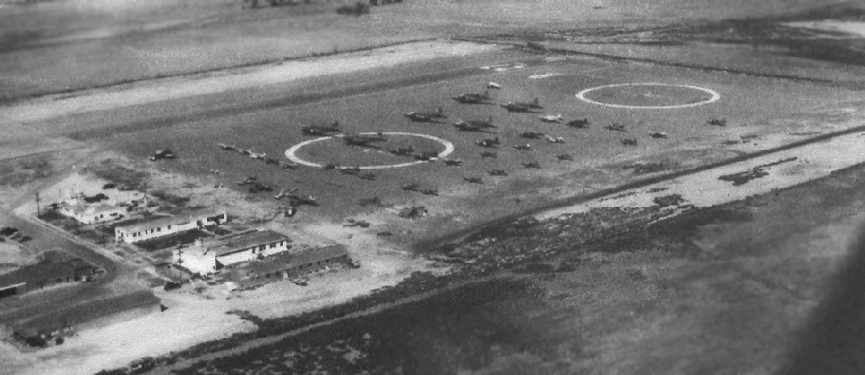
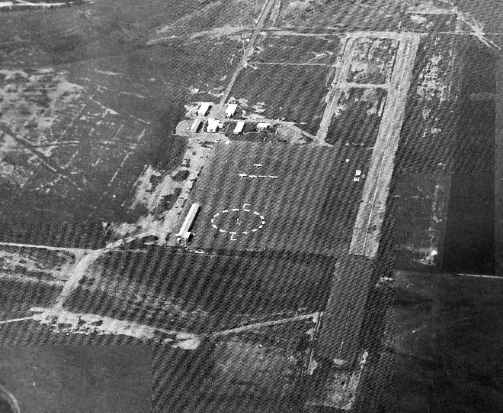
A circa 1940s aerial view looking northeast at NAAF Del Mar,
showing no less than 42 aircraft present on the field, including 6 twin-engine DC-3s/C-47s/R4Ds.
The photo is from a historical sign at the site of the airfield, photographed by Chris Kennedy in 2006.
The 1945 AAF Airfield Directory (courtesy of Scott Murdock) described Del Mar NAAS
as an 80 acre rectangular property having a 1,000' east/west asphalt landing mat & 2 paved circles.
The field was not said to have any hangars, to be owned by the U.S. Government, and operated by the Navy.
With the end of WW2, Del Mar NAAF was closed in 1945.
However, the March 1946 San Diego Sectional Chart (courtesy of Chris Kennedy) continued to depict “Del Mar (Navy)” as a military airfield.
A June 1946 Department of Commerce Airman's Guide (according to Chris Kennedy) described “Del Mar NAAF” as “No longer assigned to Navy.
Will hereafter be carried as Del Mar Airport”, as of 5/27/1946.
The Navy retained ownership of the airfield until 1947, when the 80 acres were quitclaimed to the County of San Diego for $1.
A 2,500' runway was established for fixed-wing aircraft, and the field was reused it as a civil airfield, the Del Mar Airport.
The airport also featured a popular restaurant, patio, and lounge.
Del Mar Airport was used frequently by visitors to the nearby Del Mar Hotel & racetrack.
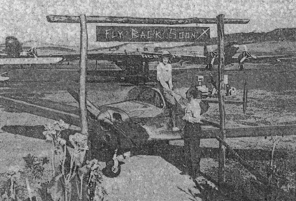
An undated photo from a 9/7/47 newspaper article (courtesy of Pam Gay of the San Diego Air & Space Museum) of an Ercoupe at Del Mar Airport , with 2 Douglas DC-3s in the background.
The photo was captioned “The personal touch brings them back, according to Hugh Tolford, one of the operators of Del Mar Airport,
shown here welcoming a guest down for racing season. Daily log shows an average of 40 ships.”
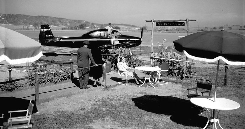
A circa late 1940s Ryan Aeronautical publicity photo of a Ryan Navion at Del Mar Airport (from the San Diego Air & Space Museum, courtesy of Aris Lazerson).
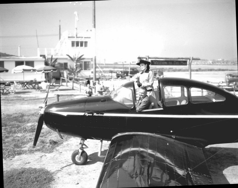
A circa late 1940s Ryan Aeronautical publicity photo of a stylish couple in their Ryan Navion at Del Mar Airport (from the San Diego Air & Space Museum, courtesy of Aris Lazerson).
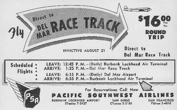
A circa late 1940s advertisement for Pacific Southwest Airlines DC-3 service
from Burbank to the Del Mar Airport (courtesy of the PSA History Museum).
Former WW2 Marine pilot James “Skeets” Coleman oversaw the operation of Del Mar Airport from 1948-50.
An undated aerial view looking north at Del Mar Airport from the 1950 Air Photo Guide (courtesy of Kevin Walsh),
which described Del Mar Airport as having a 2,600' paved Runway 8/26, and listed the manager as James Coleman.
The March 1951 San Diego USAF Sectional Chart (courtesy of Chris Kennedy)
depicted the Del Mar Airport as having a 2,500' unpaved runway.
In 1952 the old airport buildings were leased to a young Del Mar engineer, Andrew Kay,
who started Non-Linear Systems, initially producing digital voltmeters.
Work at NLS eventually led to the production of the "Kaypro", one of the first home computers.
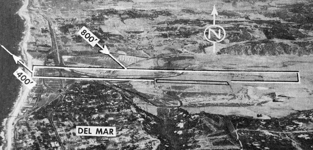
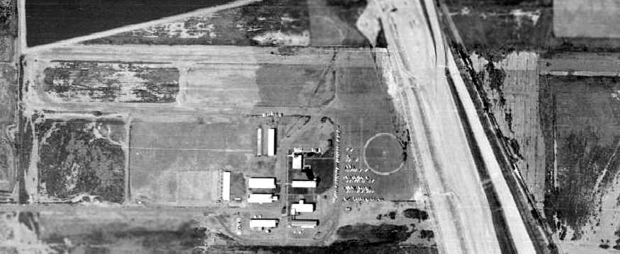
The 1953 USGS topo map (courtesy of Mark Dossett) depicted the Del Mar Airport as having a single east/west paved runway, with a parallel taxiway,
a ramp on the southeast corner, and a total of 7 small buildings.
The 1953 Southern California Flight Chart (courtesy of Scott O'Donnell)
depicted Del Mar Airport as having a 2,500' hard surface runway.
A 4/11/53 aerial view (from the UCSB Library) depicted Del Mar Airport as having a paved east/west runway, along with what appeared to have been a runway extension across the road to the west.
The 2 WW2 Navy blimp mooring circles were still recognizable on the southeast portion, with 5 light single-engine aircraft parked over the western blimp circle.
Del Mar Airport was listed among active airfields in the "Aerodromes" table
on the 1955 San Diego Sectional Aeronautical Chart (courtesy of John Voss).
It described the field as having a single 2,500' bituminous runway.
Del Mar Airport, as depicted on a 1957 street map (courtesy of Kevin Walsh).
The last photo which has been located showing Del Mar Airport while it was still in operation was a circa 1958 aerial view.
It depicted Del Mar Airport as having a paved east/west runway.
The 2 WW2 Navy blimp mooring circles were still recognizable on the southeast portion, with the eastern circle having been reused as the segmented circle,
and 5 light single-engine aircraft were parked over the western blimp circle.
The last aeronautical chart depiction which has been located of the Del Mar Airport
was on the September 1959 San Diego Sectional Chart (courtesy of Chris Kennedy).
It depicted the Del Mar Airport as having a 3,200' hard surface runway.
Unfortunately the Del Mar Airport was closed in 1959,
and the property was transferred to the State as part of the right-of-way for the the new Interstate 5.
A big white “X” was displayed on the runway, indicating the closure of the field
(according to a historical sign at the site of the airfield, photographed in 2006 by Chris Kennedy).
Interstate 5 was eventually built through the eastern portion of the Del Mar Airport property.
By the time of the September 1961 San Diego Local Aeronautical Chart (courtesy of Chris Kennedy)
the former Del Mar Airport was depicted as “Abandoned Airport”
(even though the new freeway which caused its closure was not yet depicted at all).
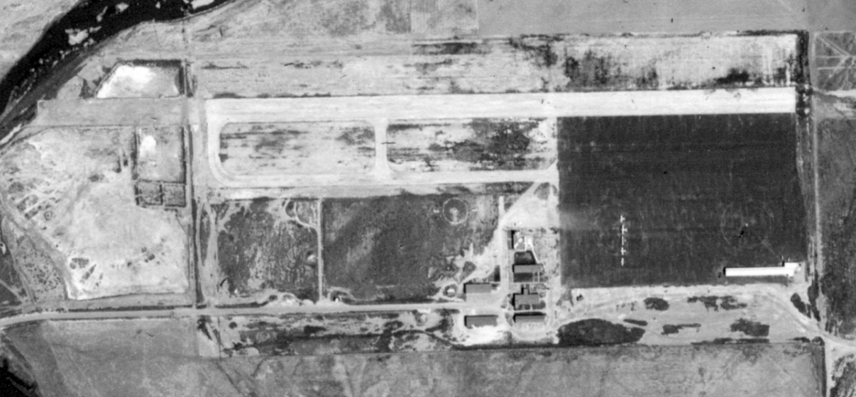
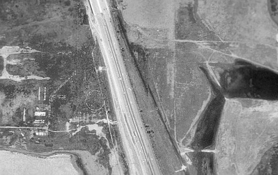
A 1964 aerial view showed the site of the Del Mar Airport, with the newly-built Interstate crossing right over the eastern portion of the runway & ramp.
The airport was otherwise still intact, with one blimp circle still visible,
the runway & parallel taxiway still intact, and all of the airport buildings still standing.
Non-Linear Systems continued to operate from the former barracks on the western side of the Del Mar Airport property until 1968,
when it relocated to Solana Beach.
A 1980 aerial photo shows that the former Del Mar Airport buildings were removed at some point between 1964-80.
The site of the Del Mar Airport, as seen in the 1994 USGS aerial photo.
Amazingly, by comparing this with the aerial photos from previous years, it may be seen that the remains of the western blimp mooring circle are still barely evident,
right next to the western side of Interstate 5.
The foundations of the airfield buildings are also still evident, in the same layout as in the picture from 51 years before.
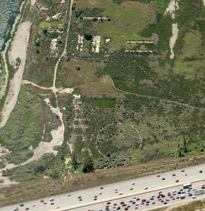
Incredibly, a circa 2006 aerial photo looking west at the site of Del Mar Airport
shows that the blimp mooring circle & foundations of the airfield buildings were still evident, 47 years after the airport was abandoned.
Josh Neubauer reported in 2006, “The foundations & blimp mooring circle of the Del Mar Airport
are being torn up for the San Dieguito Lagoon Restoration project.
It was interesting seeing the well-defined outlines of the shallow holes where each structure once stood.”
Unfortunately, John Voss reported of the former Del Mar airfield in 2007, “It's gone.
There were a number of earth movers, bulldozers & scrapers moving about the entire area making a lot of dust.
They appear to be preparing the area for home sites... or possibly another golf course!
This activity was all to the west of Interstate 5.
I would imagine that there is a bit of runway remaining to the east of the highway
but due to excessive weed growth nothing could be observed.”
A 2008 aerial photo shows that the majority of the former airport property (on the west side of the freeway) has now been flooded.
The only remaining trace of the former Del Mar Airport on that side of the freeway
is now the road leading to the airport (from the west).
Chris Kennedy reported in 2008 that on the east side of the freeway, “There is some pavement visible, but it is heavily overgrown.
Also, wetlands restoration is being done on that side too, so it may not be there long.”
A March 2010 photo by Mark Dossett of a plaque commemorating the history of Del Mar Airport, with the site of the airport in the background.
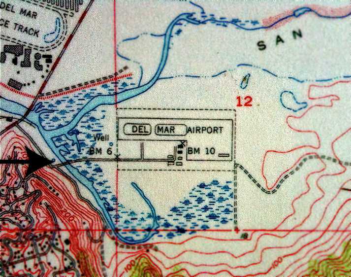
The site of Del Mar Airport is situated at the end of Grand Avenue (known previously as Palm Lane), which is directly off of San Dieguito Drive.
The site now includes part of the San Dieguito River Regional Park & a portion of Interstate 5.
A 1998 Army Corps of Engineers report provides more details about Del Mar.
____________________________________________________
Camp Pendleton Highway Airstrip, Oceanside, CA
33.305, -117.472 (West of Camp Pendleton MCAS, CA)
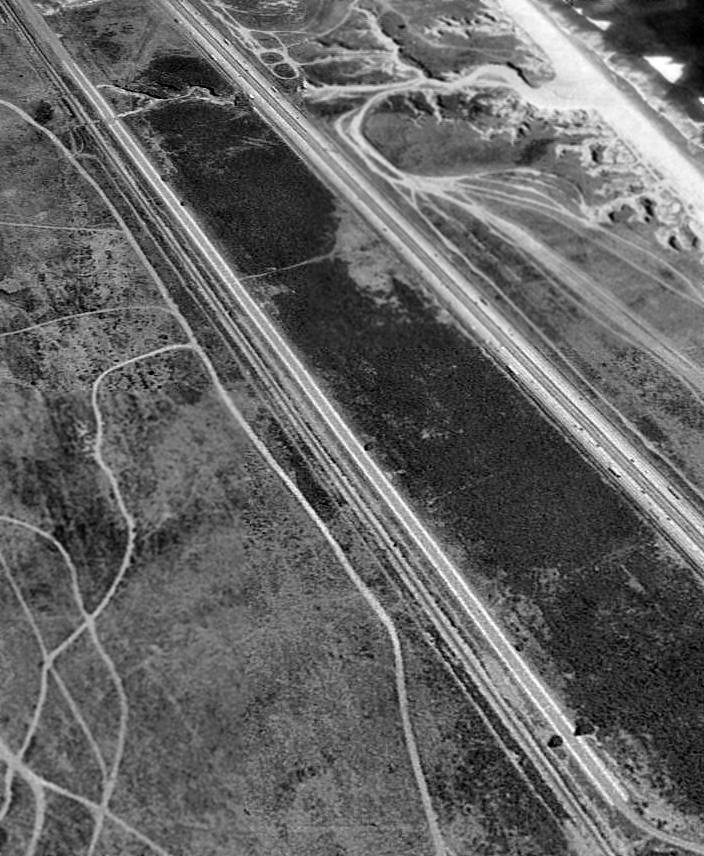
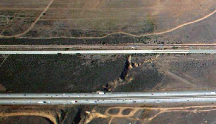
A 10/2/95 USGS aerial view looking southeast at the Camp Pendleton Highway Airstrip.
Photo of the airfield while open has not been located.
The Marine Corps' massive Camp Pendleton has several other airfields in addition to its primary Marine Corps Air Facility.
The date of construction of the Highway Airstrip has not been determined.
No airfield at this location was listed in the 1945 AAF Airfield Directory (courtesy of Scott Murdock)
nor depicted on the 1945 or 1955 San Diego Sectional Aeronautical Charts (courtesy of John Voss).
It was not yet depicted on a 1946 aerial photo, but was shown on a 1981 aerial photo.
The 1968 & 1979 USGS topo maps only depicted the road, without any indication of any aviation use.
Matt Galusha reported that "on the abandoned Pacific Coast Highway, just north of the Las Pulgas exit,
there's about a mile of the highway that was refinished by the Marines for practice operations [flight operations].
The whole route there on old Pacific Coast Highway / Route 101 is a bike & jogging route
that can be closed without notice for government operations.
It is about 5,000' of concrete. It's very narrow but in great condition.
There are power lines fairly close to the road, so whatever they land there, it is small.
I couldn't find any cornerstones that would indicate a date of construction."
Samuel Dean recalled, “One Wednesday sometime around 1999 or 2000
when we came onto that stretch to find a half-dozen or so USMC Harriers (AV-8Bs?) landed there & being refueled.
I guess power lines aren't as much of a concern for VTOLs!”
Two 2004 photos by Matt Galusha of the former Camp Pendleton Highway Airstrip.
A 2007 aerial view by Nick Taylor looking northeast the the Camp Pendleton Highway Airstrip.
The site of the Camp Pendleton Highway Airstrip is located northwest of the intersection of Las Pulgas Road & Interstate 5.
____________________________________________________
Camp Pendleton Marine Corps Strip #2, Oceanside, CA
33.26, -117.435 (West of Camp Pendleton MCAS, CA)
The 1949 San Diego Sectional Chart (courtesy of Chris Kennedy)
depicted "Camp Pendleton #2 (Navy)" as having a 900' unpaved runway.
Photo of the airfield while in use has not been located.
Camp Pendleton's "other" airfield was situated directly along the Pacific coast,
5 miles southwest of the base's primary airfield.
The date of construction of Camp Pendleton Strip #2 has not been precisely determined.
It may have been built between 1945-49,
as it was not listed among active airfields 1945 AAF Airfield Directory (courtesy of Scott Murdock)
nor depicted on the 1945 San Diego Sectional Aeronautical Chart,
and a 1946 aerial view did not show any trace of an airfield.
The earliest depiction of the Camp Pendleton #2 airfield which has been located
was on the 1949 San Diego Sectional Chart (courtesy of Chris Kennedy).
It depicted "Camp Pendleton #2 (Navy)" as having a 900' unpaved runway.
The last aeronautical chart depiction which has been located of the Camp Pendleton #2 airfield
was on the 1955 San Diego Sectional Aeronautical Chart(courtesy of John Voss).
The Aerodromes table described Camp Pendleton Strip #2 as consisting of a single 900' oiled runway,
along with the remark, "Navy. Closed to all civilian aircraft."
The Camp Pendleton Strip #2 was evidently closed at some point between 1955-65,
as it was no longer depicted on the August 1965 Sectional Chart (courtesy of Ron Kunse).
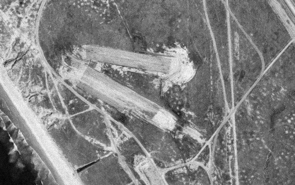
The earliest photo that has been located of the Camp Pendleton Strip #2 was a 5/8/67 aerial view.
It depicted the field as having 2 dirt runways,
with no sign of any buildings or other improvements.
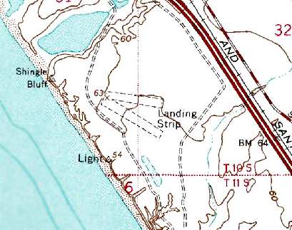
The Camp Pendleton Strip #2 was labeled simply as "Landing Strip" on the 1968 USGS topo map.
It depicted two 1,000' unpaved runways.
The 1979 USGS topo map continued to depict the "Landing Strip" as having two 1,000' runways.
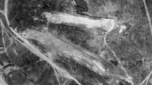
The last photo that has been located of the Camp Pendleton Strip #2 was a 1980 aerial view.
A 1981 aerial view depicted the site in an unchanged manner.
In one of the most unusual reuses of a former military airfield,
at some point between 1981-90 the land at Strip #2 was used to build the base for the Navy's west coast LCAC hovercraft fleet.
LCACs are used to transport tanks, equipment and personnel from amphibious assault ships onto a beach.
They are 87' long & weigh 200 tons at full load..
The LCAC base at Camp Pendleton consists of a 2,000' x 1,200' concrete pad,
together with 4 hovercraft hangars & a taxiway leading out to the beach.
It resembles an airfield in many ways,
even having a control tower along the beach to manage the flow of hovercraft traffic.
No trace remains of the former airfield,
as the LCAC base completely covers the site of the runways.
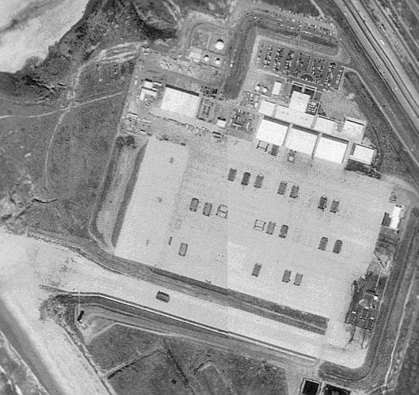
The 1996 USGS aerial photo, showing the Camp Pendletons LCAC hovercraft base which had covered the site of the former airfield.
There are a total of 20 hovercraft visible at the base,
including one heading along the taxiway at the south end toward the Pacific Ocean.
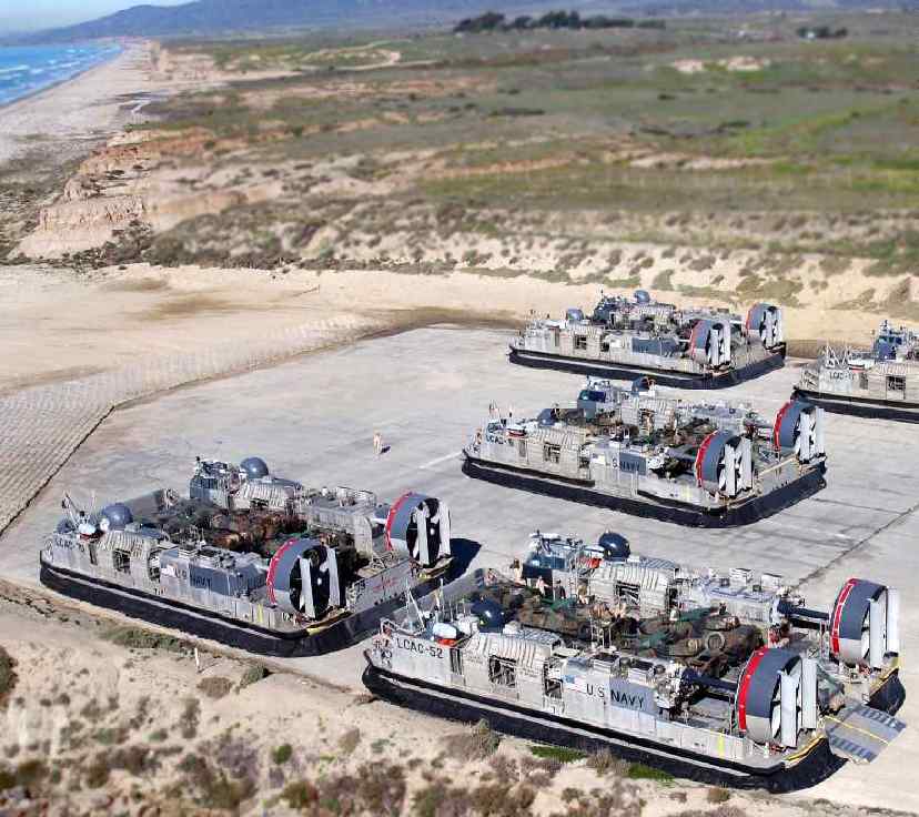
A 2007 aerial view by Nick Taylor looking east at the site of the former Camp Pendleton Strip #2, now the Camp Pendleton LCAC base.
The site of Camp Pendleton Strip #2 is located along the Pacific Coast,
at the intersection of Interstate 5 & Phillips Street.
____________________________________________________
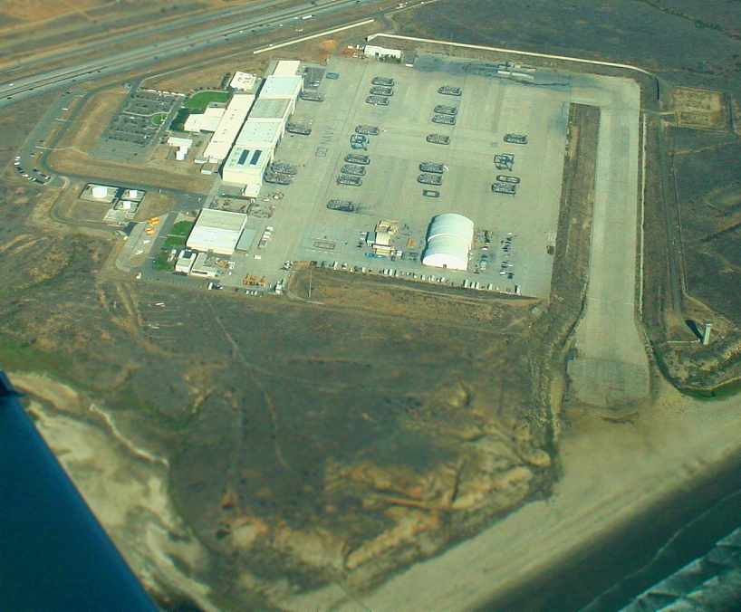
Red Beach Marine Corps Airfield, Oceanside, CA
33.286, -117.457 (West of Camp Pendleton MCAS, CA)
A 1990 aerial photo depicted the Red Beach Airfield as having a single paved runway with a parallel taxiway,
and several paved helicopter/VTOL pads.
This is yet another airfield located along Camp Pendleton's Pacific coast,
a mere 2 miles further up the coast from the LCAC base.
The Red Beach Airfield was evidently constructed at some point between 1981-90,
as it was not yet depicted on a 1981 aerial photo.
The earliest depiction which has been located of the Red Beach Airfield was on a 1990 aerial view.
It depicted Red Beach as having a single 1,500' paved runway,
along with taxiways & a paved ramp area.
The runway was painted with markings to resemble the deck of an LHA helicopter carrier.
There were no hangars on the site.
According to Steve Simpson (a former Marine Air Traffic Controller
who was stationed at Camp Pendleton in the mid to late 1990s),
this airfield "was known to military pilots & controllers as 'Red Beach' airfield.
I do remember there was a SID [Standard Instrument Departure] called the 'Red Beach 1'
that took departures from Camp Pendleton there,
though this SID was outdated when I was there.
Some interesting facts about the airfield are that it was outfitted with a temporary air traffic control tower
during major exercises & staffed with controllers from our deployable unit that lived at the airfield during these exercises.
Also in addition to helicopters we had about a dozen Harriers stationed there during exercises in 1997."
A 9/26/01 USGS aerial view showed the Red Beach Airfield in a similar configuration as the 1990 photo.
The Red Beach Airfield was not depicted on 2002 aeronautical charts,
and it was not listed among active military airfields in published FAA records as of 2002.
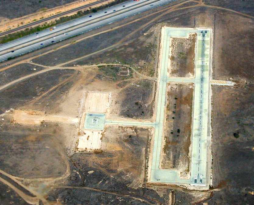
A 2007 aerial view by Nick Taylor looking east at the Red Beach Airfield.
An 11/12/13 aerial photo of the Red Beach Airfield showed it basically unchanged from the 2007 aerial photo.
The Red Beach airfield is located along the Pacific Coast, south of the intersection of Interstate 5 & Las Pulgas Road.
____________________________________________________
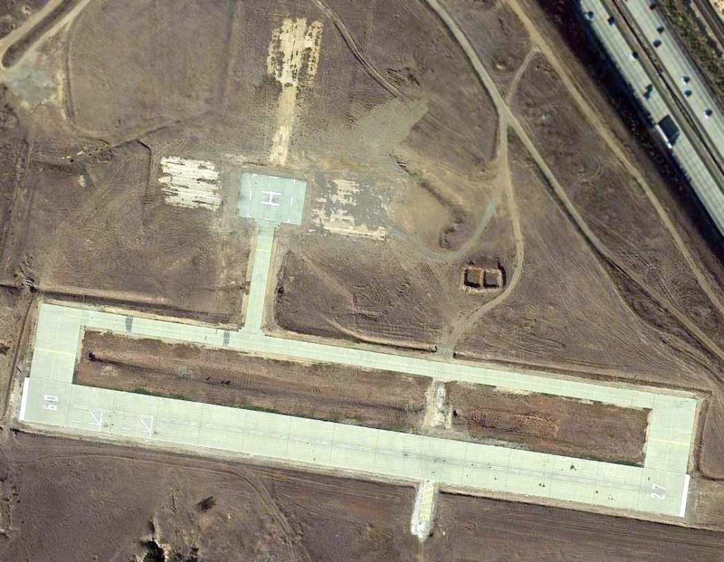
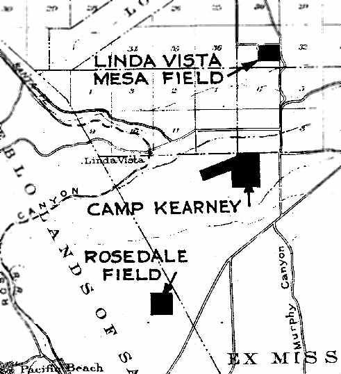
Linda Vista Mesa Field / Hourglass Field / Miramar Naval Outer Landing Field, Mira Mesa, CA
32.91, -117.125 (North of San Diego, CA)
“Linda Vista Mesa Field”, as depicted on the June 1938 “Map Showing Locations of Leased Auxiliary Landing Fields,
Naval Operating Base San Diego” (courtesy of Brian Rehwinkel).
Photo of the airfield while in use has not been located.
This airfield was known throughout the years as Linda Vita Mesa Field, Hourglass Field (due to the shape of its runways), and Miramar NOLF,
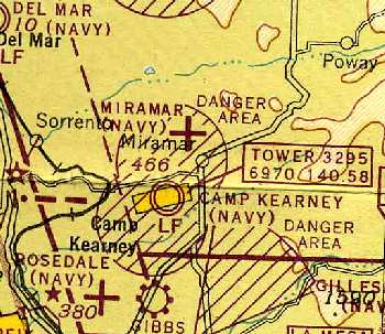
but it should not be confused with the much larger present-day NAS Miramar / MCAS Miramar (located 3 miles to the south).
According to auto racing historian Bret Kepner, Hourglass Field was one of the oldest of the San Diego-area military air installations.
Linda Vista Mesa Field had its start in 1931.
Lease paperwork from September & November 1931 (from an Army Corps of Engineers report courtesy of John Pollard)
detailed the Navy's lease of “Area K” & “Area L” for an auxiliary field to support flight training in San Diego.
According to Brian Rehwinkel, “I have a picture that shows Linda Vista Mesa in 1933 & there was an airfield at that spot with a landing circle.
I strongly suspect it was being used by the Navy in 1933.”
The earliest depiction of the field which has been located
was on a June 1938 map of Leased Auxiliary Airfields for NAS San Diego (according to Brian Rehwinkel).
It labeled it as the “Linda Vista Mesa Field”,
and depicted it simply as a rectangular outline.
The earliest photo which has been located of Linda Vista Mesa Field was a 11/17/39 aerial view looking west (courtesy of Brian Rehwinkel).
Brian observed, “You can see the east/west sod runway area in the center portion of the field.
Notice the L-shaped runway boundary markers at the east & west ends of the field – with the landing circle in the middle of the field.
You can also see an unknown Navy biplane on the eastern end of the field.
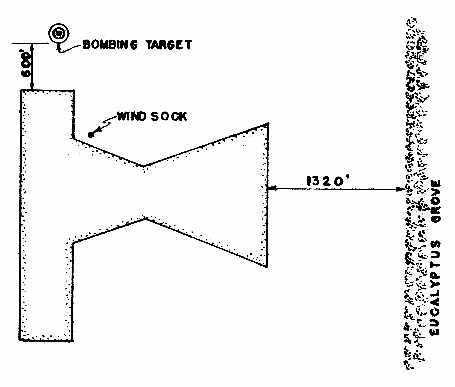
A bomb target is located just north of the designated landing field.”
According to Brian Rehwinkel, “In late 1939, the Navy’s 11th District recommended that several of the leased San Diego should be purchased by the Navy.
Miramar Field was one of the fields the Navy wanted to purchase.
In 1941, the Navy apparently purchased the 160 acre field from the San Diego Water Company.”
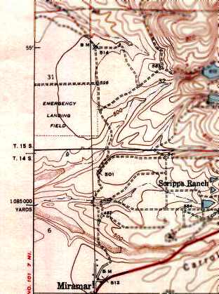
The 1942 USGS topo map depicted the “Emergency Landing Field” as having a rectangular outline.
A March 1942 photo (courtesy of Brian Rehwinkel) showed the field during the construction of paved runways,
which replaced the 1930s era rectangular unpaved field.
The bomb target had been moved north, completely beyond the boundary of the original field.
However the original L-shaped runway boundary markers (that were present in the 1939 photo) were still visible in the 1942 photo.
Strangely, no airfield at this location was depicted on the 1944 San Diego Sectional Chart (courtesy of Chris Kennedy),
nor listed among active airfields in the 1944 US Army/Navy Directory of Airfields (courtesy of Ken Mercer).
“Miramar Field / #01715 (OLF)” was depicted in a a circa 1944 directory of NAS San Diego airfields (courtesy of Brian Rehwinkel).
It described the field as having 4 asphaltic concrete runways:
2,500' Runways 3/21 & 13/31, and 2,400' Runways 9/27 & 18/36.
Miramar Field was described as being assigned to NAAS Camp Kearney (later to be known as NAS Miramar)
for administrative & maintenance purposes.
John Pollard surmised of Hourglass Field's runway configuration: “I believe the shape is the result of 2 requirements:
4 runways (north/south, east/west, northeast/southwest, northwest/southeast), and use as little asphalt as possible (reduced cost).
Overlaying an X & a + sign right on top of each other is a good start,
however offsetting the north/south runway toward the east or west uses even less asphalt as it would share more area with the diagonal runways.”
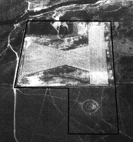
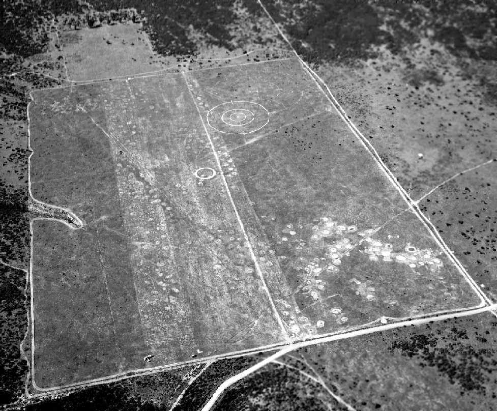
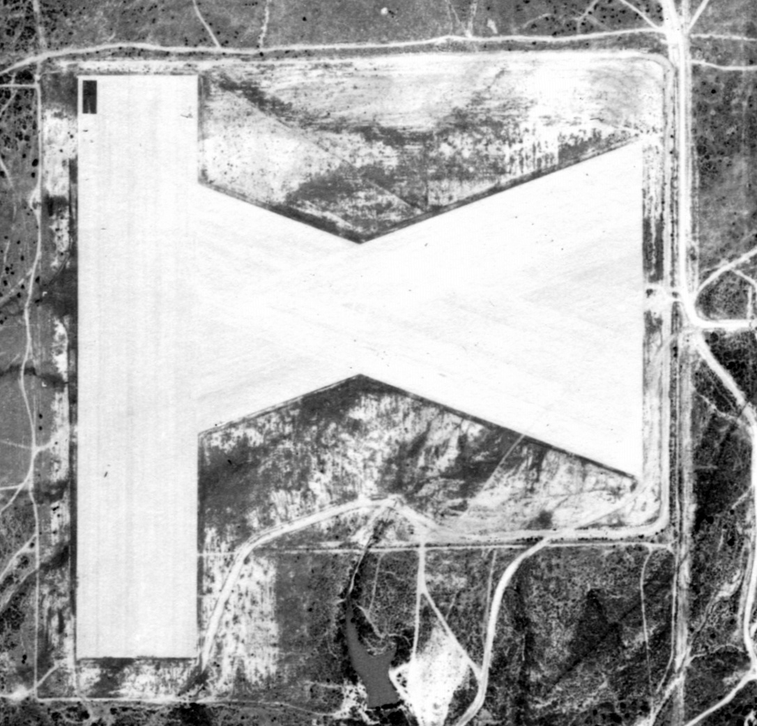
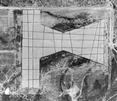
A 11/30/44 aerial view looking south at Hourglass Field (from an Army Corps of Engineers report courtesy of John Pollard),
on which the boundary around the airfield & adjacent bomb target were annotated.
The earliest aeronautical chart depiction of Hourglass Field was on the 1945 San Diego Sectional Chart (courtesy of Chris Kennedy).
It depicted the field as "Miramar (Navy)". Note that the present-day MCAS Miramar was depicted as "Camp Kearney (Navy)".
A January 1945 aerial view (courtesy of Brian Rehwinkel) showed on the western end of the field the L-shaped boundary markers of the predecessor sod runway.
As seen in a 1945 aerial view (courtesy of John Voss),
the airfield at Hourglass Field consisted of 3 paved 1,800' runways:
one oriented north/south, and northwest/southeast & northeast/southwest runways
which intersected in the form of an hourglass.
In the above 1945 aerial photo, there do not appear to have been any hangars,
or any buildings at all (other than what might have been some minor sheds).
A 300' diameter target circle was situated only 400' north of the north/south runway.
Hourglass Field was not listed among active airfields in the 1945 AAF Airfield Directory (courtesy of Scott Murdock).
An undated WW2-era Navy Airfield planning document (courtesy of John Voss)
referred to this field by another name: "Linda Vista Mesa (Miramar)".
It said: "The present use of this field is for dive bombing practice & for emergency landings.
The close proximity to Camp Kearney Field [later known as Miramar NAS/MCAS]
increases the hazard to the movements of aircraft in these 2 fields.
It is quite possible that in the near future dive bombing practice at this field will have to be greatly curtailed,
if not entirely suspended.
In this case the recommended development would be
the construction of 3 'standard' runways for practice & carrier landings."
The February 1946 San Diego Sectional Chart (courtesy of Chris Kennedy),
continued to depict "Miramar (Navy)" as an auxiliary airfield.
At some point between 1946-51, the Miramar/Hourglass airfield was evidently relinquished by the Navy and reused as a civilian airfield,
as that is how “Miramar” was depicted on the March 1951 San Diego USAF Sectional Chart (courtesy of Chris Kennedy).
It described the field as having a 2,400' hard surface runway.
However, the Aerodromes table listed the field's "type" as blank (the only blank one in the whole table),
and the remarks said "Closed".
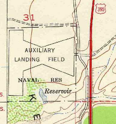
Hourglas Field was depicted as “Auxiliary Landing Field, Naval Reservation”
on the 1952 USGS topo map (courtesy of Chris Kennedy).
A 3/31/53 aerial view (from the UCSB Library) depicted the airfield at Hourglass Field to remain intact but without any sign of recent use.
The airfield was listed as "Miramar OLF" in the "Aerodromes" table
on the 1955 San Diego Sectional Aeronautical Chart (courtesy of John Voss).
It described the field as having 4 bituminous runways (the longest being 2,400').
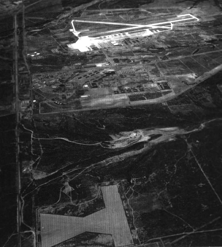
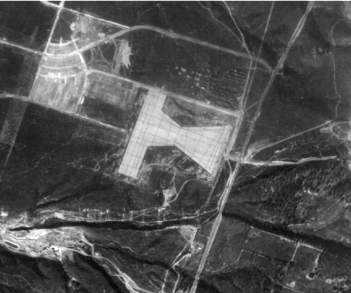
A 1956 aerial view looking south (courtesy of John Voss),
showing how closely located Hourglass Field (bottom of picture) was to Miramar (top of picture).
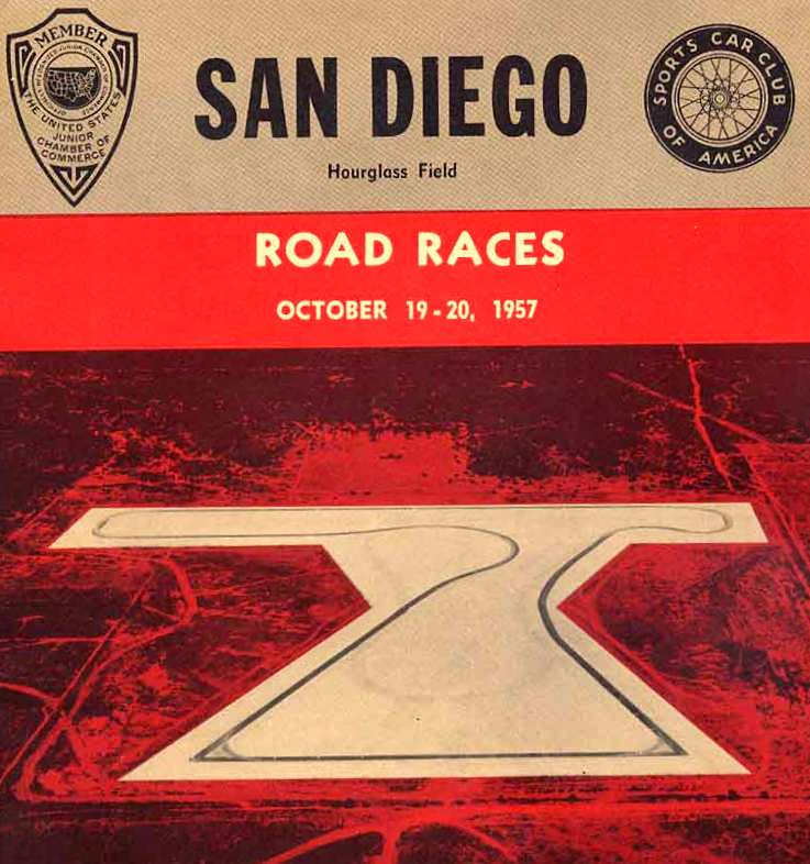
The cover of a program for an auto race conducted at Hourglass Field in 1957.
After the former Paradise Mesa Field was closed as a drag strip,
Hourglass Field was also reused for a short time starting in 1957 for auto races,
with a 1.8 mile loop laid out along the former runways.
By the time of the 1962 San Diego Local Aeronautical Chart (according to Chris Kennedy),
Hourglass Field was no longer depicted at all.
Bob Wilson recalled, “I flew radio-controlled [model] airplanes at Hourglass Field 1963–67.
It had been plowed up so they couldn’t race cars, but was large enough for us to fly and land our model planes.”
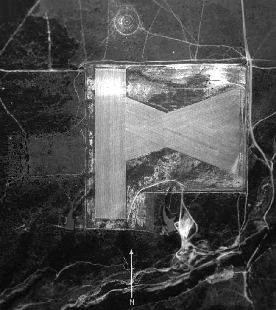
A 1964 aerial view showed that all of the airfield pavement of the former Hourglass Field remained,
but it had been criss-crossed with trenches that were apparently cut to prevent drag-racing.
An undated aerial view of Hourglass Field (courtesy of Ron Plante), presumably of the same vintage as the preceding 1964 photo.
In 1967, the Miramar campus of the San Diego Community College was built on the site of the airfield.
Sherman Gregory recalled, “I remember visiting Hourglass Field probably in 1969.
A friend of mine's father took us there to watch radio-controlled airplanes flying.
At that time the tarmac was there,
but was crossed-hatched with trenches that I was told were cut to keep people from drag racing there.”
A 1972 aerial photo showed that all of the airfield pavement still remained,
but school buildings had been constructed just southeast of the airfield,
and a small building had been built on the northwest corner of the airfield.
A 1980 aerial photo showed that a road had been built through the western portion of the former Hourglass Field,
and several buildings had been built over the portion of the former airfield on the western side of the road.
Phil Wells visited the site of Hourglass Field in 2004.
His report: "I went out to Miramar College to see if there was still any sign of Hourglass Field.
The south half of the 'X' is gone; paved or turfed over.
But if you stand just southwest of the concession stand of the Little League baseball fields
(north of the college parking & south of Hillary Drive), and look left & right,
you can see some really chewed up old tarmac.
Barely visible unless you know what you¹re looking for.
If, from this apparent center of the top two 45 degree runway sections,
you walk toward Black Mountain Road,
you'll see that the broken tarmac continues & once you get to Black Mountain Rd & look back
you can tell that this is the northern edge of the section of runway running from the northwest toward the center.
Also the parking area south of the concession stand seems to have its northern border at the right place
to be the north edge of the section running from the northeast to the center.
The north/south runway to the west is totally covered by schools."
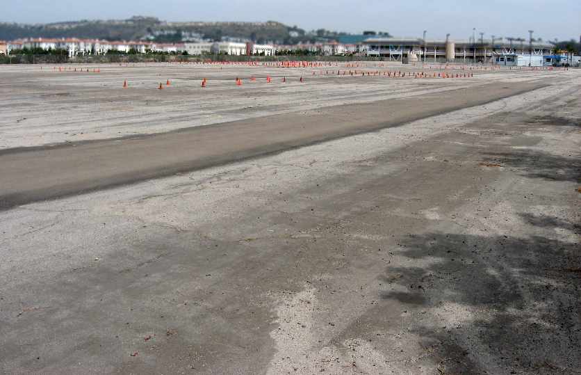
A 2007 photo by John Voss of what appears to be former airfield pavement at the site of Hourglass Field.
John observed “an asphalt area at the very north & west end of the Community College boundary...
This area (about 5-7 acres) has very old & crumbling asphalt
and indeed appears to be the only remaining portion of the airfield.
There are a number of red traffic cones spotted throughout the area for probable driving proficiency training.
A possible Go-Kart track may be there as well.
The former bombing target was probably situated about where the Home Depot is located.”
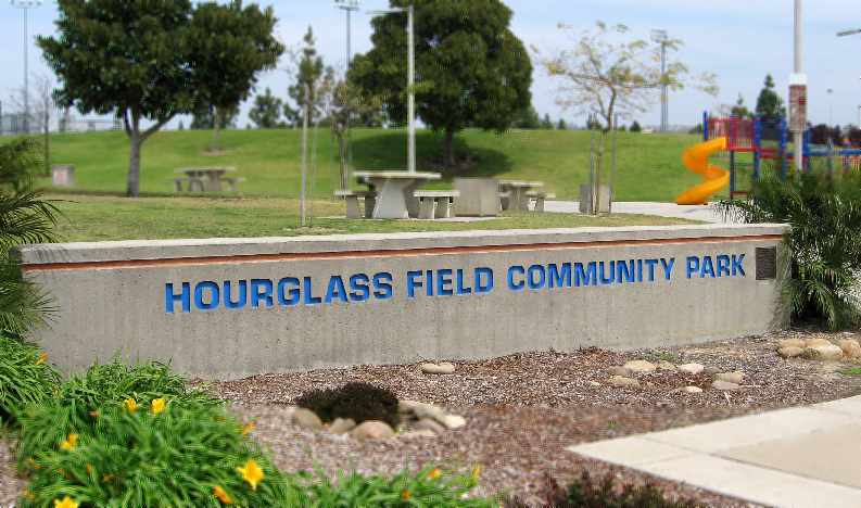
A 2007 photo by John Voss of the sign for the “Hourglass Field Community Park”.
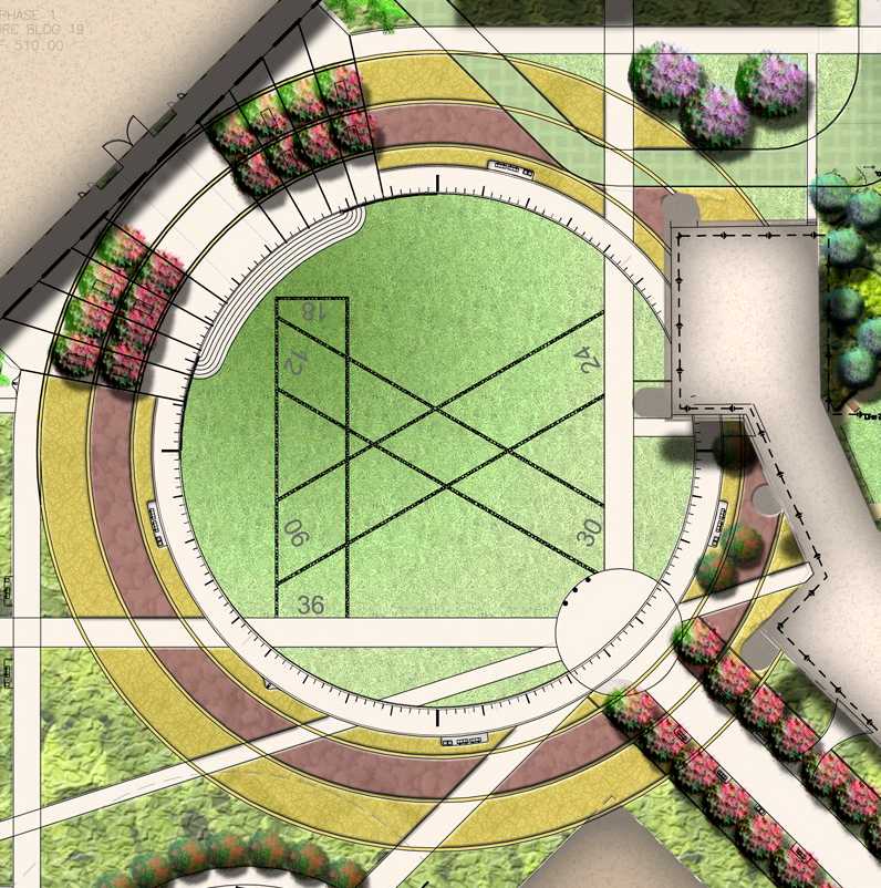
A 2011 rendering (courtesy of Brad Hilliker) of the Hourglass Field airfield layout
incorporated into a newly-built feature at the center of the Miramar College campus.
Brad Hilliker (of Wimmer Yamada and Caughey, Landscape Architecture) reported in 2011,
“We’ve designed a special site feature for Miramar College,
acknowledging the historical importance of Hourglass Field on the campus.
As a part of a 42-acre redevelopment of the campus we’ve designed a large azimuth compass feature in the heart of the campus.
This 310' diameter, 16' width paving element incorporates degree & compass headings
along with a miniature version of the original Hourglass Field set into the ground plane.
The site design recognizes and celebrates the important history of aviation at this location.
In the Central Commons area, natural flagstone is set into the ground plane, shaped in the form of the original Hourglass Field runways.
The flagstone pavers incorporate LED lighting set within the middle of each run,
spaced about 12' on-center, thus creating a special nighttime experience.
The flagstone runways are set within a giant circular azimuth compass.
The giant circular azimuth compass reaches out in massive arcs to create pedestrian walkways
that gracefully connect the surrounding buildings, both new & existing.
Numbers for airfield runways are based on compass headings, hence the compass azimuth feature in the ground plane.
The azimuth compass is embedded with degree & compass headings which are the basis of guidance for aircraft pilots.
Brass markers are used for the north/south/east/west numerals & at every 10-degree tic mark of the compass.
Moving forward, Miramar College offers educational programs in aviation maintenance & aviation mechanics.
The past connects with the future.
The project is currently under construction.
We’re going to install an interpretive sign with photos describing the original Hourglass Field
and how airport runways are numbered based upon the features of the azimuth compass.
We feel it’s important for the community and the students at Miramar College to know & understand the rich history of their site.”
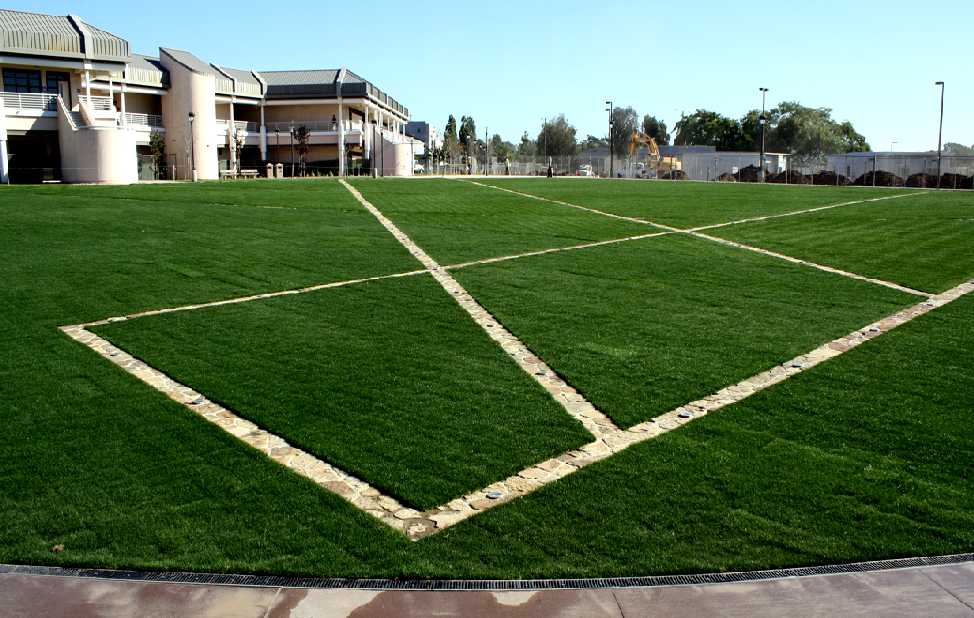
A 2011 photo (courtesy of Brad Hilliker) looking southeast at the newly-built Hourglass Field airfield layout
incorporated into the center of the Miramar College campus.
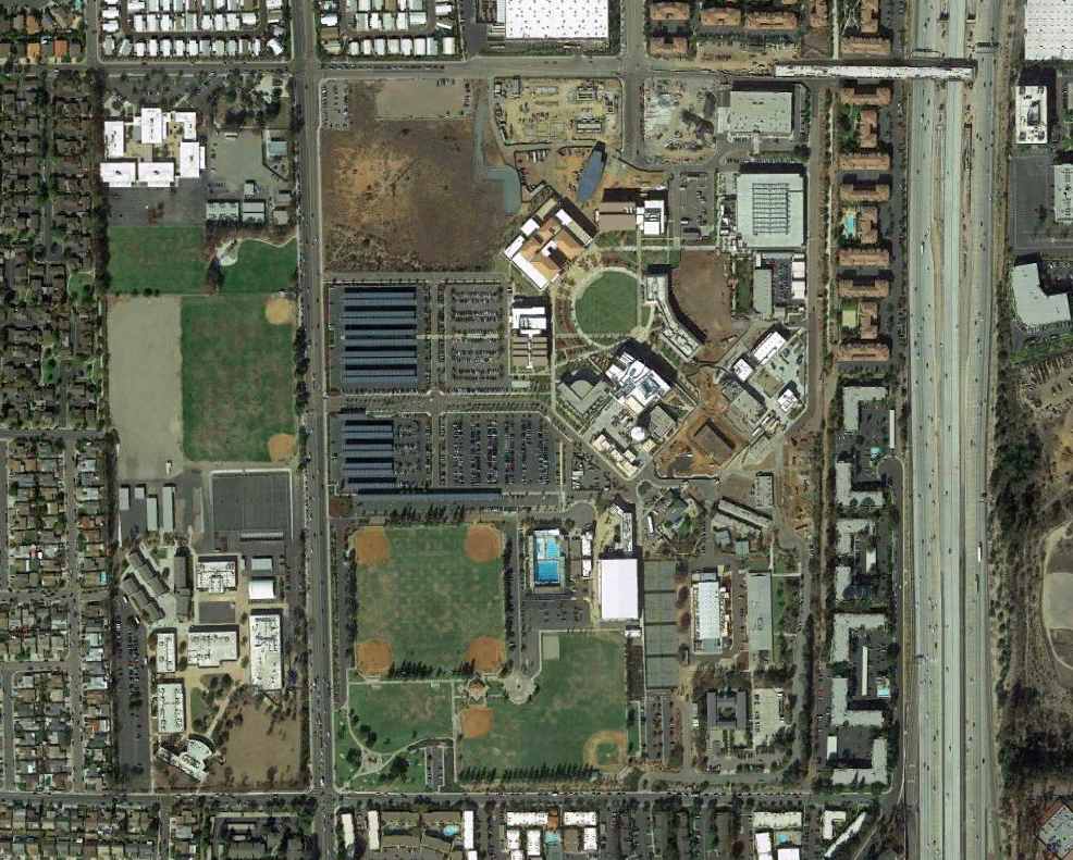
An 11/13/13 aerial photo of the site of Hourglass Field,
now the location of the Miramar campus of the San Diego Community College.
The airfield site is northeast of the intersection of Black Mountain Road & Gold Coast Drive,
just 3 miles north of the present-day Miramar MCAS.
See also: http://home.san.rr.com/fsheff/coversb.htm
____________________________________________________
Since this site was first put on the web in 1999, its popularity has grown tremendously.
If the total quantity of material on this site is to continue to grow,
it will require ever-increasing funding to pay its expenses.
Therefore, I request financial contributions from site visitors,
to help defray the increasing costs of the site
and ensure that it continues to be available & to grow.
What would you pay for a good aviation magazine, or a good aviation book?
Please consider a donation of an equivalent amount, at the least.
This site is not supported by commercial advertising –
it is purely supported by donations.
If you enjoy the site, and would like to make a financial contribution,
you
may use a credit card via
![]() :
:
Please consider checking the box to make a monthly donatation.
For a mailing address to send a check, please contact me at: paulandterryfreeman@gmail.com
If you enjoy this web site, please support it with a financial contribution.
This site covers airfields in all 50 states.