
Abandoned & Little-Known Airfields:
California: Southern Palmdale area
© 2002, © 2023 by Paul Freeman. Revised 11/21/23.
This site covers airfields in all 50 states: Click here for the site's main menu.
____________________________________________________
Please consider a financial contribution to support the continued growth & operation of this site.
For a 9th year, the CA pages of this website are sponsored by the California Pilots Association:
Krey Field (added 1/31/17) - Quartz Hill Airport (revised 11/21/23)
Victorville AAF Aux #3 / El Mirage Airport (revised 9/14/23) - Victorville AAF Aux #4 / Grey Butte Airfield (revised 12/12/19)
____________________________________________________
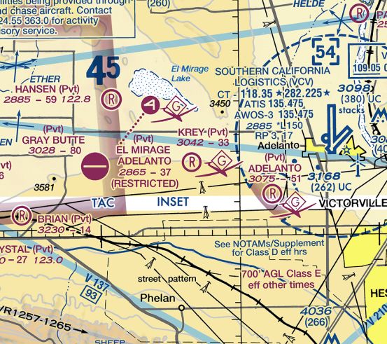
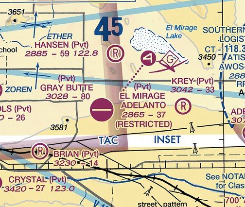
Krey Field (0CL1), Adelanto, CA
34.569, -117.556 (Southeast of Palmdale, CA)
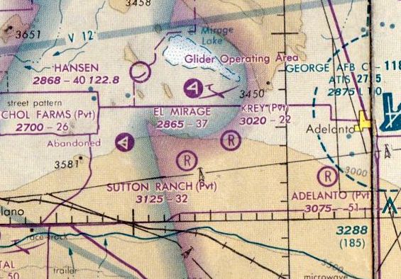
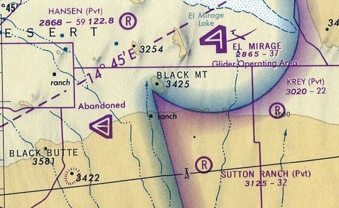
Krey Field, as depicted on the January 1979 LA Sectional Chart (courtesy of Mitchell Hymowitz).
Krey Field was evidently established at some point between 1969-79,
as it was not yet depicted on the February 1969 LA Sectional Chart (courtesy of Ron Plante).
The earliest depiction which has been located of Krey Field was on the January 1979 LA Sectional Chart (courtesy of Mitchell Hymowitz).
It depicted Krey as a private airfield having a 2,200' unpaved runway.
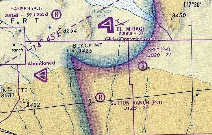
The August 1980 LA Terminal Aeronautical Chart (courtesy of Mitchell Hymowitz)
depicted Krey Field as a private airfield having a 2,200' unpaved runway.
According to its FAA Airport/Facility Directory data, Krey Field had an activation date of October 1987,
but that is strangely contracted by its depiction on aeronautical charts at least 8 years prior to that date.
According to the Krey Field website, it began operation in 1987, as “one of Socal Soaring's best kept secrets.”
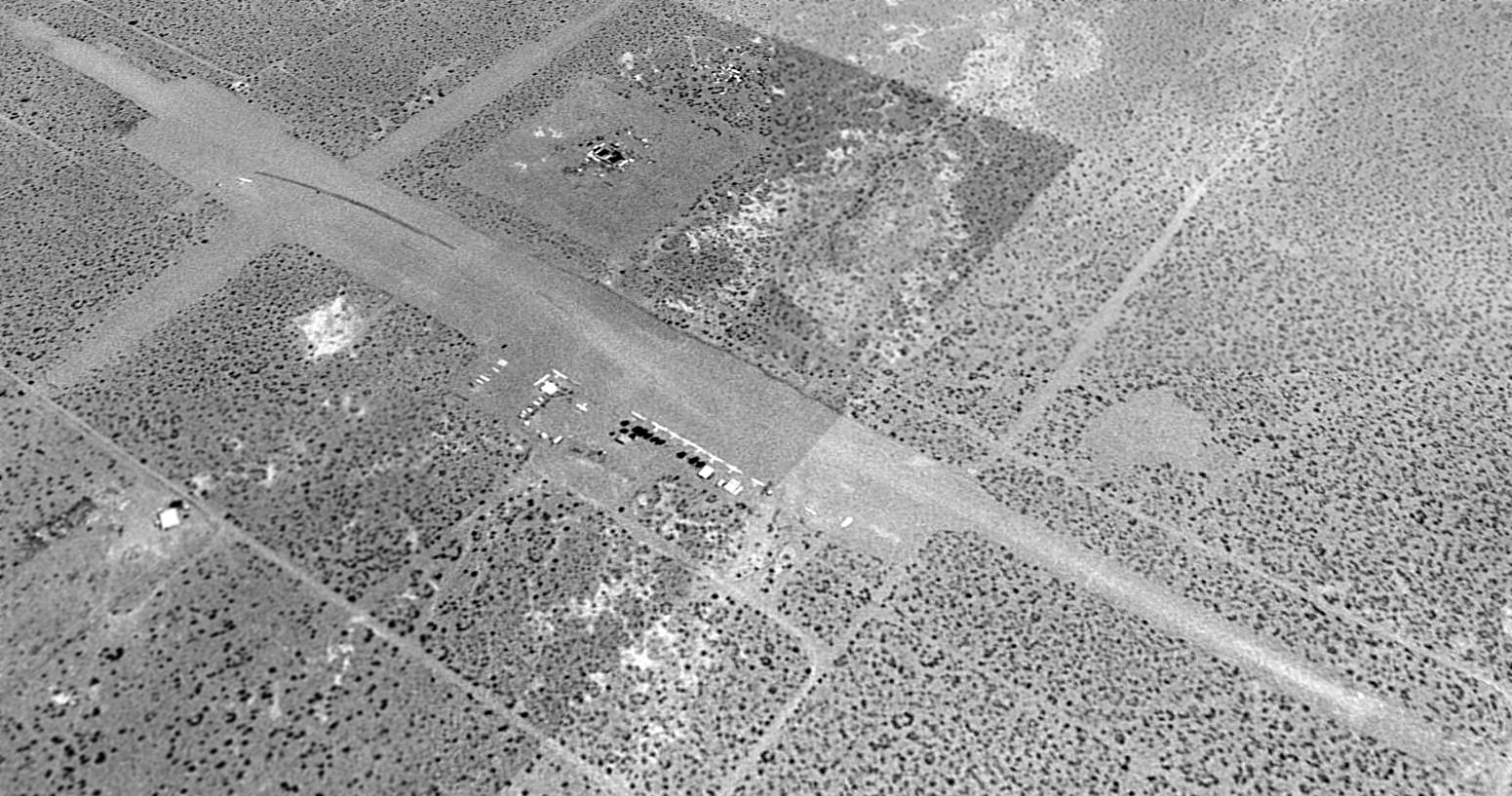
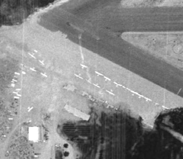
The earliest photo which has been located of Krey Field was a 1994 USGS aerial view looking southeast.
It depicted Krey as having 2 perpendicular unpaved runways, and a dozen light aircraft parked near the buildings on the northeast side.
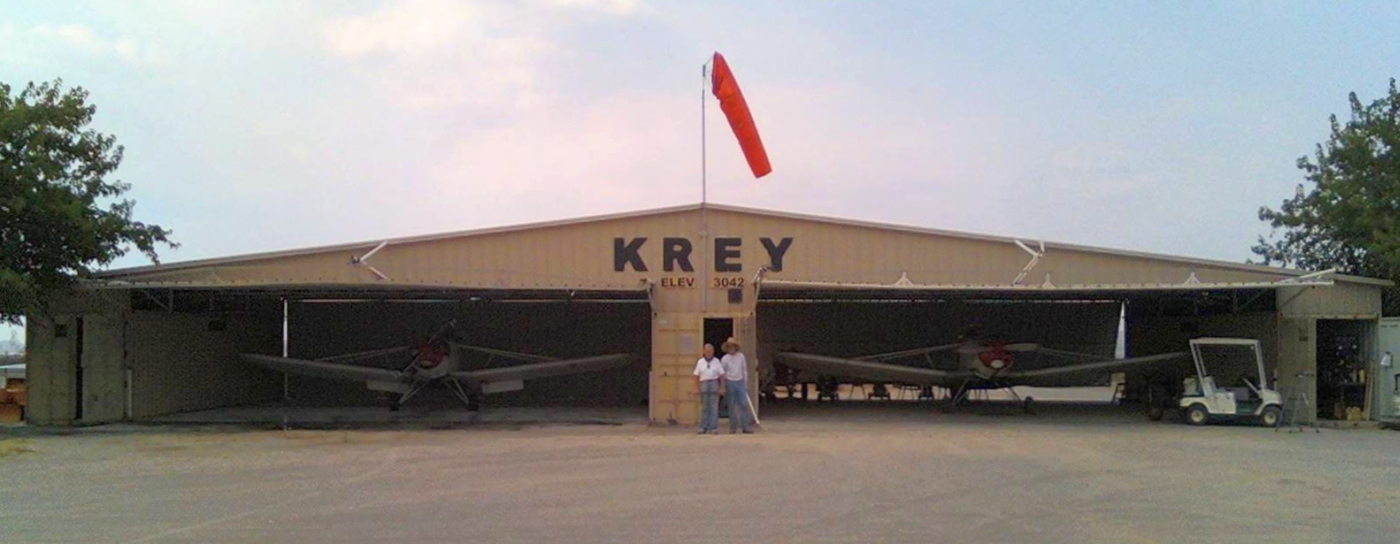
An undated photo of the main Krey Field hangar, with 2 Piper Pawnee towplanes inside.
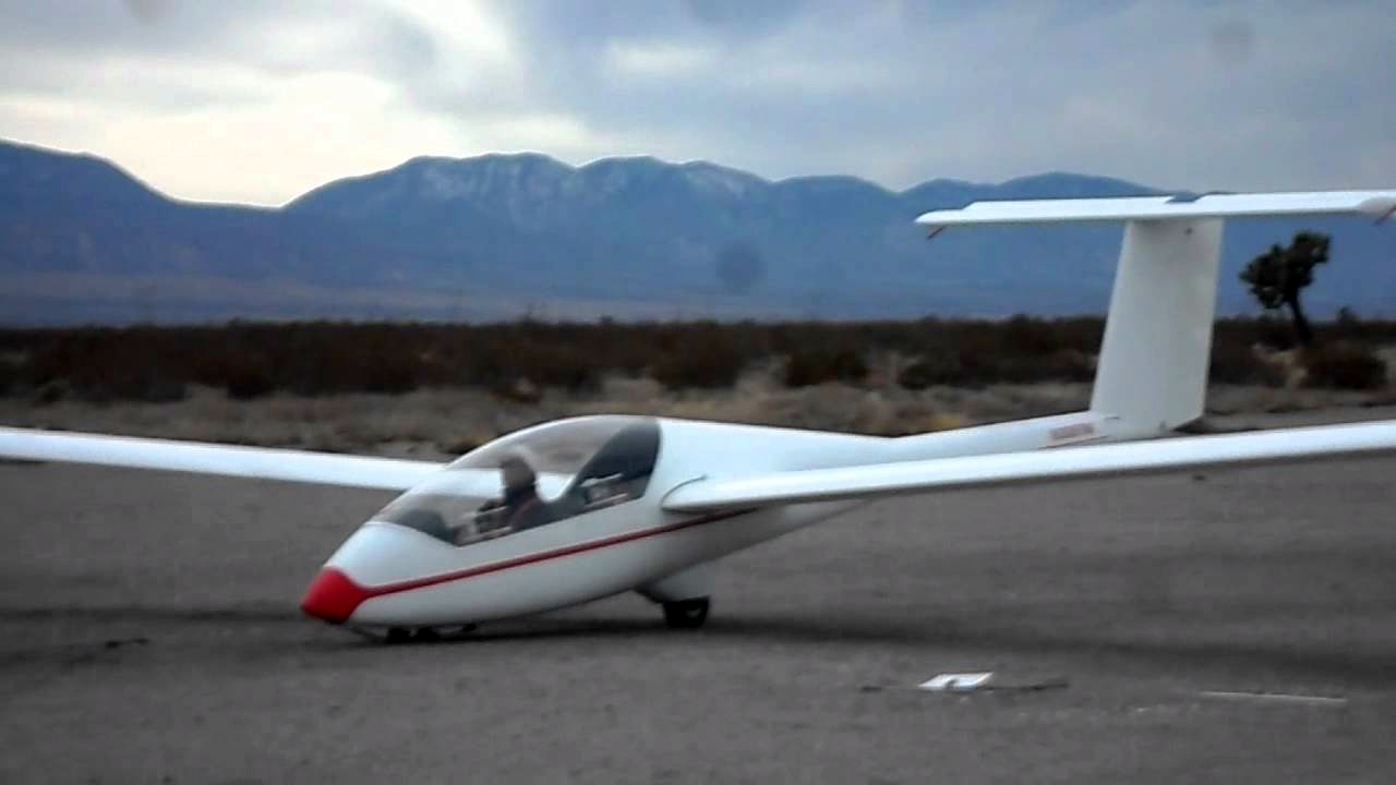
A 1/14/02 photo of Bert Briones first solo flight, in a glider (model unidentified) from Cypress Soaring at Krey Field.
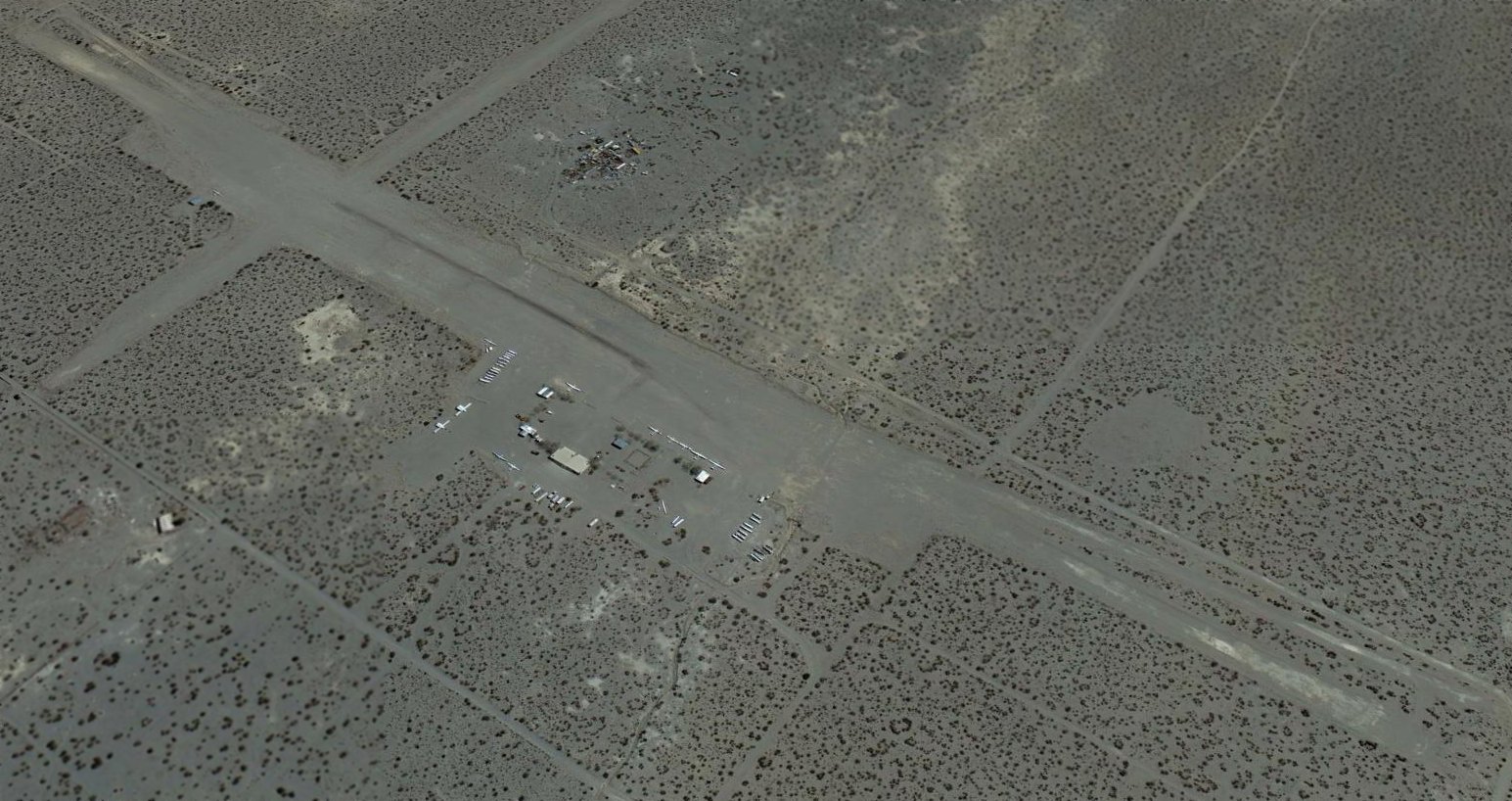
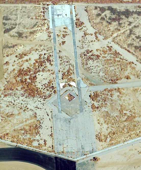
A 2013 aerial view looking southeast at Krey Field.
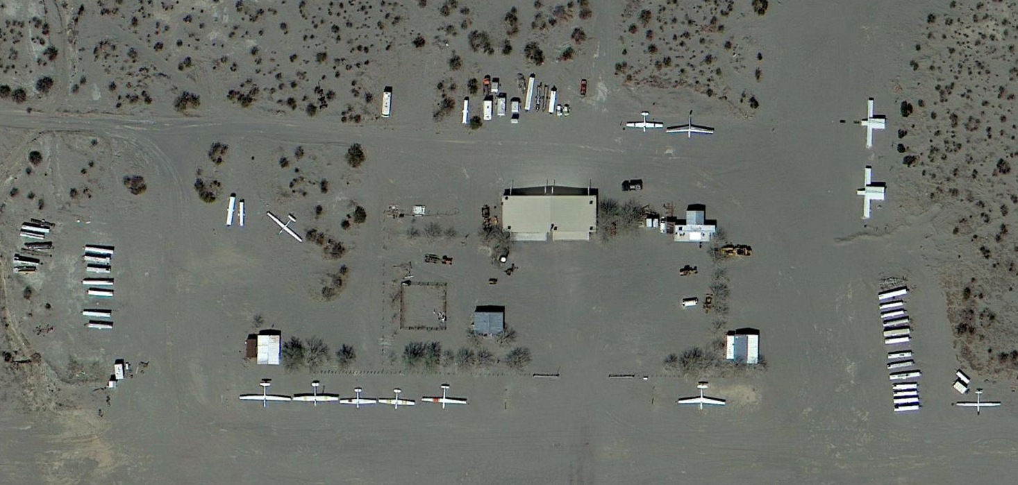
A 2013 aerial view showing Krey Field perhaps at its zenith of popularity, with 10 gliders visible parked outside, and over 20 trailers for other gliders.
According to the Krey Field website, it ceased operation in 2014.
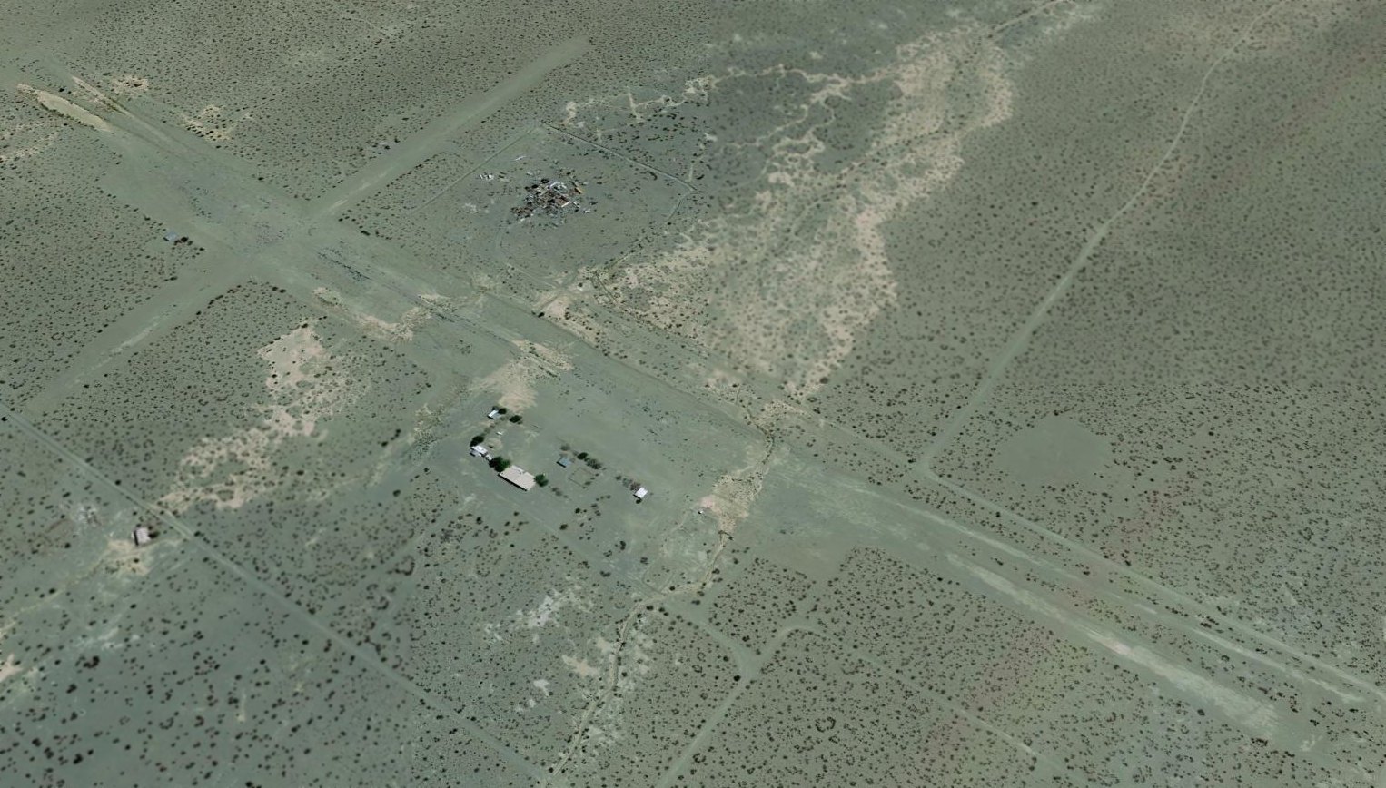
A 2016 aerial view looking southeast at Krey Field.
A 2016 aerial view showing the last aircraft remaining at Krey Field: one glider in a fenced-in compound on the southeast side.
Krey Field was still depicted on the June 2016 LA Sectional Chart, even though it had been closed already for 2 years by that point.
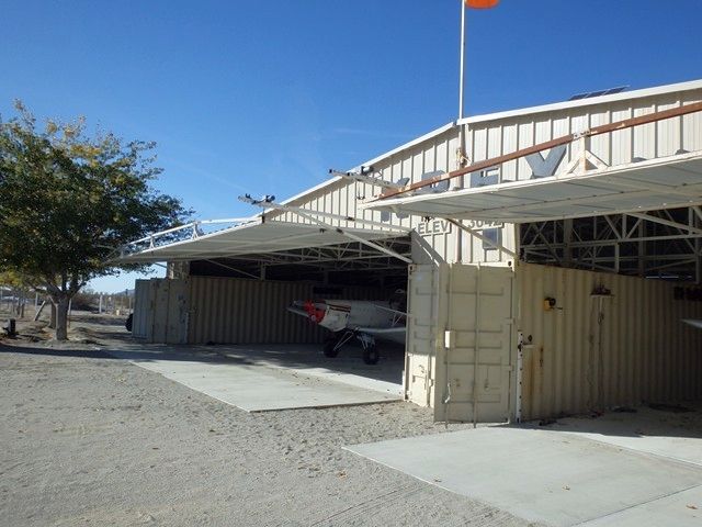
A pre-2017 photo of a Piper Pawnee towplane inside the Krey Field hangar.
As of 2017, Krey Field's FAA Airport/Facility Directory data described it as having 2 runways: a 3,360' asphalt/dirt Runway 7/27 & a 2,040' dirt Runway 16/34.
The owner was listed as the John Frank Krey Revocable Living Trust, and the manager as Robert Wall.
The field was said to have 37 based aircraft: 2 single-engine aircraft & 35 gliders.
Krey Field is located southeast of the intersection of Johnson Road & Parkdale Road.
Thanks to Leigh Kelly for pointing out this airfield.
____________________________________________________
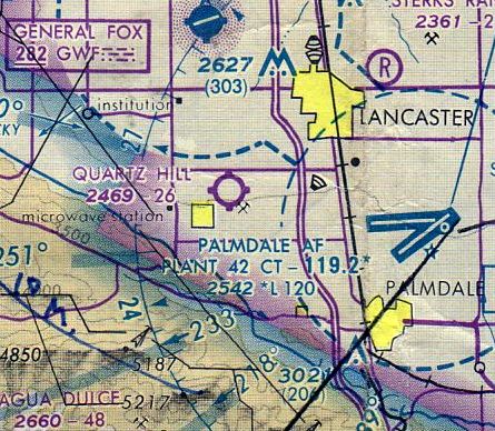
Quartz Hill Airport, Quartz Hill, CA
34.651, -118.206 (West of Palmdale, CA)
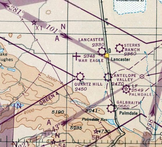
Quartz Hill Airport, as seen on the September 1947 LA Sectional Chart.
Quartz Hill Airport was not yet listed among active airfields in the 1945 AAF Airfield Directory (courtesy of Scott Murdock).
This small general aviation airport reportedly opened in 1946.
However, it was not yet depicted at all on the February 1947 LA Sectional Chart (courtesy of Chris Kennedy).
According to Sandra Pike, Quartz Hill Airport was “started in the 1940s” by her dad & uncle, William "Lloyd" Pike & Fillmore A. "FA" Hoak.
“They called it P&H Flying Service.
I have some memories of the airport and flying as a little girl.
My dad, Lloyd Pike was well known in the development of the Antelope Valley & its road system.
He trained many pilots in the area.”
The earliest aeronautical chart depiction of Quartz Hill Airport which has been located was on the September 1947 LA Sectional Chart.
It depicted Quartz Hill as a commercial/municipal airport.
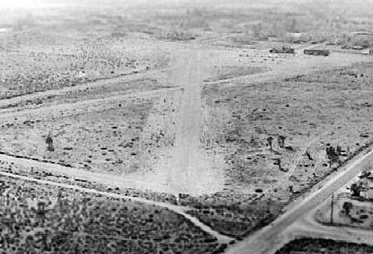
The earliest photo which has been located of Quartz Hill Airport was an 11/20/48 USGS aerial view.
It depicted the field as having 2 unpaved runways, with 3 light aircraft & some small buildings on the west side of the field.
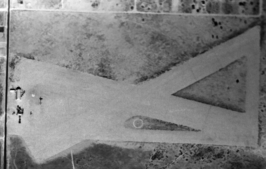
A 1953 aerial view depicted Quartz Hill Airport as having 2 unpaved runways in an “X” shape.
A dozen light aircraft & small buildings were on the west side of the field.
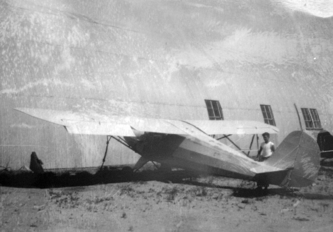
A circa 1955-56 photo (courtesy of Bonnie Watts Baker) of her father's plane (an Aeronca Chief?) that he kept at at Quartz Hill Airport.
Bonnie recalled, “He built this plane & I remember going out there & playing while he was working.
I recall the red ant hill on one side of the plane & the black ant hill on the other side. I would bring a jelly sandwich to the black ants.
The person in the picture is my older brother Jim Watts.
My Dad's name was Lory Watts & he was a flyer in the Air Corps in the 1940s.
He parked this plane at Quartz Hill as long as he had it.
I have another picture of a plane sitting next to the Quonset hut office.
The story goes that it was the plane used for the movie about Lindbergh. It has 'The Spirit of St Louis' paint on the side.”
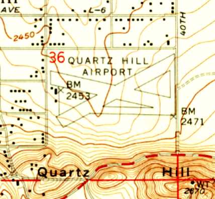
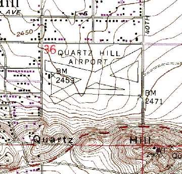
The 1958 USGS topo map depicted Quartz Hill Airport as having 2 runways & 3 small buildings on the west side.
Tom Maddux recalled, “In the 1958-59 school year at George Washington High School in south LA I took a class in aeronautics.
As a culmination of the class we were sent in groups of 3 out to Hawthorne Airport.
We went up for a demonstration ride in a Cessna 172. My leg was from Hawthorne to Quartz Hill.
I remember dirt runways & a little shed that served as an office.”
Rick Metzgar recalled, “My Dad, an Army Air Corps instructor during WW II, was giving private flying lessons at Quartz Hill Airport in the late 1950s.”
The 1962 AOPA Airport Directory described Quartz Hill Airport as having 2 gravel runways: 2,640' Runway 4/22 & 2,190' Runway 13/31.
It listed the operator as Antelope Valley Aeronautical.
The 1962 movie "The Skydivers" was apparently filmed at Quartz Hill Airport (according to Henry Krasker).
Louis Spencer recalled, “I flew my Stinson Voyager out of Quartz Hill airport 1963 through most of 1964.
I didn't know how great flying really was back then until I look back on it now 40+ years later.”
Brian Baker recalled a flight in 1963 or 1964, "At Quartz Hill, I recall landing on the dirt runways,
and remember taking off, that the runway did indeed have a noticeable dip in the center,
and I just barely cleared the trees at the end of the runway.
That's a loaded 65 hp. Luscombe on a hot summer day.
I also recall seeing an old Aeronca L in a hangar there,
and as I'm an avid aircraft photographer, I had him roll it out for me to photograph it.
I think he offered to trade me straight across for the Luscombe,
but since my Dad was an Aeronca dealer in Detroit before the war,
he told me that it was the worst airplane Aeronca ever built, so I declined."
Fred Austin recalled, “Quartz Hill... I had a Ryan PT22 in 1963/64 & spent a lot of time flying around the Lancaster-Palmdale-Mojave area.
There were a lot of little strips out there then. There was a fellow at Quartz Hill for a while that had a low wing Aeronca.
His name was Solberg. He was a nice guy I used to drop in & talk with him from time to time.
There was a kind of Quonset Hut hangar there buy the trees on the west end of the field. If it had a door at one time it was gone it would have faced south.
There was always plenty of sand & tumbleweeds in the hangar. I dropped by one day & Mr. Solberg had the airplane in the back of the hangar.
It was masked off with old newspapers & he was putting a paint job on it. That was the 1960's & things didn't have to be as perfect as they do today.
He told me he was going to make a trip back to the Midwest where he had some family & he wanted the ship to look good.”
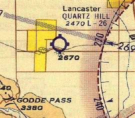
Quartz Hill Airport, as depicted on the August 1964 LA Local Aeronautical Chart (courtesy of Donald Felton).
The Aerodromes table on the 1964 LA Sectional Chart (courtesy of John Voss)
described Quartz Hill Airport as having 2 gravel runways, with the longest being 2,640'.
Greg Houck recalled, “During the 1969-75 timespan my family lived in Lancaster.
My dad, Jim Houck, was a general aviation pilot.
He was a Certified Flight Instructor & after leaving the Marines he started, in conjunction with 2 business partners, a Fixed Base Operator which was first based at Quartz Hill.”
A 1971 aerial view looking southwest at Quartz Hill Airport (courtesy of Dick Landgraff).
USGS topo map 1974.
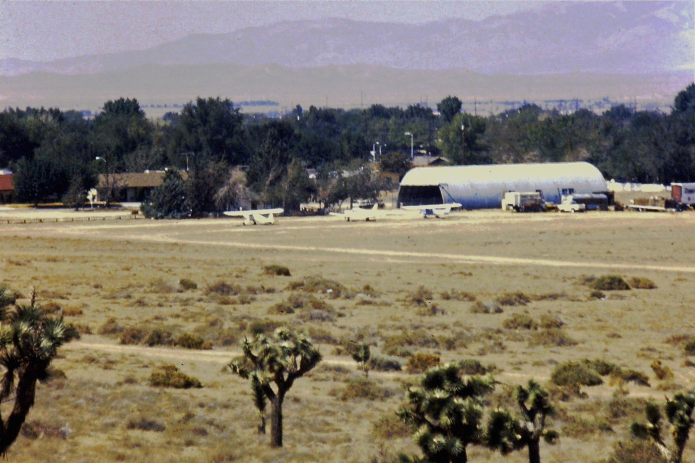
A 1974 aerial view depicted Quartz Hills Airport as having a total of 20 single-engine aircraft parked near a Quonset hut on the west side of the field.
Quartz Hill was still listed as a public-use airport in the 1977 Pilot's Guide to CA Airports (according to Chris Kennedy),
along with the note, "Caution: All runways slope downhill to mid-field."
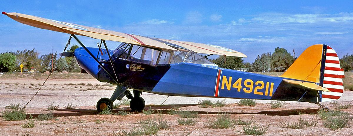
A 9/24/77 photo of Taylorcraft DCO-65 C/n 5969 N49211 at Quartz Hill Airport.
Charles Roskam recalled, “While I was training for my commercial license in the late 1970s
I flew out of Quartz Hill Airport a number of times.
It was a privately-owned airport. A man named 'Doc' owned it. His is an interesting story.
He was a record producer in LA but got into the usual Hollywood lifestyle, fast women, drugs, etc.
He lost his family & much of his wealth because of his type of living.
He became a Christian, moved to Quartz Hill, bought the airport, and lived in a trailer on the field with his new wife.
He was a very intelligent guy & very personable.”
Jim Fitzgerald recalled, “I used to fly a Cessna 170 out of 'Quartz Hill International'
as we Lockheed Flight Testers used to refer to it.
More than once I would taxi into position & have to hold till the horse crowd cleared the runway.
I miss that place.”
The last aeronautical chart depiction which has been located of Quartz Hill Airport
was on the January 1980 LA Sectional Chart (courtesy of Mitchell Hymowitz).
It depicted Quartz Hill Airport as having a 2,600' unpaved runway.
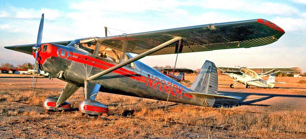
A September 1981 photo of beautiful Luscbome 8E Silvaire C/n 4787 N2060K at Quartz Hill Airport.
By 1982, the status of Quartz Hill had changed to a private field,
as the remarks in the 1982 AOPA Airport Directory (courtesy of Ed Drury) said, "Private. Closed to public."
It described the field as having 2 dirt runways: 2,550' Runway 5/23 & 2,300' Runway 9/27.
It listed the operator as Antelope Valley Aeronautical.
Quartz Hill Airport had evidently been closed by 1982, as it was no longer depicted on the January 1982 LA Sectional Chart.
According to Jon Karkow, "The area around the airport was - and still is - popular for riding horses.
It was common to have to buzz the strip to get the riders to move off of the runways!
A Mojave resident told me that one day his buzzing caused a horse to spook & throw its rider.
There was hell to pay after he had landed.
When I arrived in this area in 1986 there were at least a dozen airplanes there.
It closed that year due to the press of housing developments.
It was bounded by 40th Street West, 45th Street West, Avenue M, and Avenue L-8."
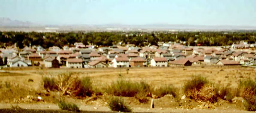
The last photo which has been located of Quartz Hill Airport was a December 1987 photo by John Durkos.
John observed, the picture was “overlooking the airport from the hill on Avenue M on the south boundary of the airport.
The picture is looking towards the northwest with the Tehachapi Mountains in the background.
The airport was closed when I took the picture. I can’t vouch for the airworthiness of the planes so they might have been left over & trucked out or scrapped.”
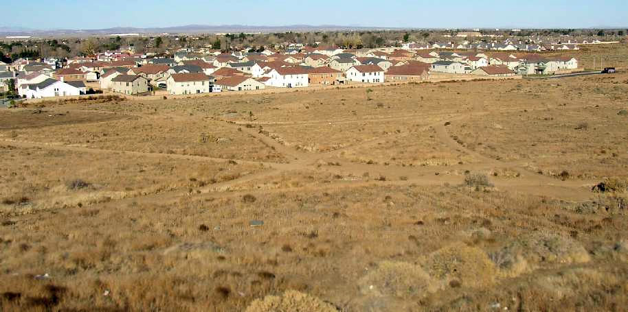
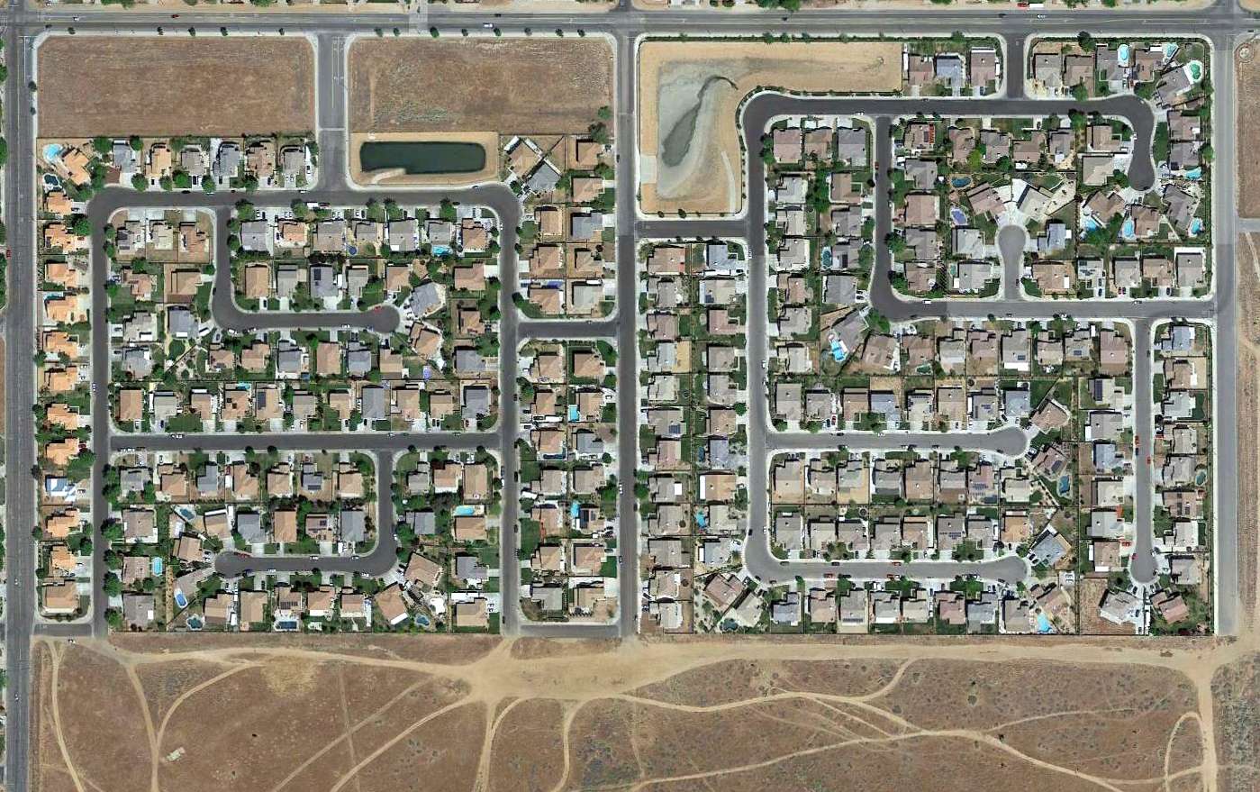
A 1994 USGS aerial photo showed that housing developments had been built over the western & northeastern portions of the site of Quartz Hill Airport.
A 2003 photo by Jon Karkow looking northeast at the site of Quartz Hill Airport from the southwest corner of the property.
John reported, "The intersection of the runways was right in the center of the photo.
The hangars would have been on the far left of the shot where there are now houses.
There is a new housing development on the north side of the property. None of the street names have an airport theme."
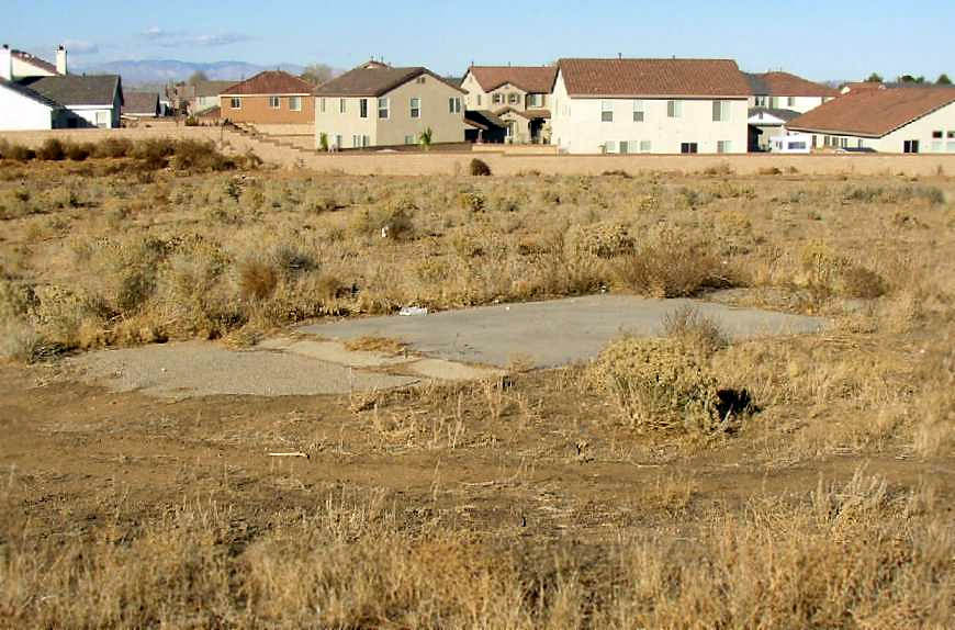
A 2003 photo by Jon Karkow looking north at the remains of the concrete run-up pad at the southwest corner of the airfield property.
John reported, "The airport had dirt runways. On the southeast & southwest ends of the airport there were concrete run-up pads with asphalt transitions.
These were the only remaining traces of the airport that I could find."
A 2004 photo by Don Hyneman taken from the top of the Avenue M hill looking to the northeast over what was the site of Quartz Hill Airport.
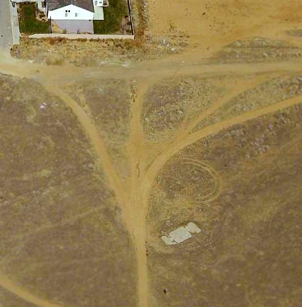
A circa 2005 aerial photo of what appears to be the only remaining trace of the former Quartz Hill Airport
a concrete run-up pad at the southwest corner of the airfield property.
Although a 2015 aerial photo shows houses covering the majority of the Quartz Hill Airport site,
a close inspection reveals the concrete run-up pad at the southwest corner of the airfield property remains the last small trace of this grassroots airport.
____________________________________________________
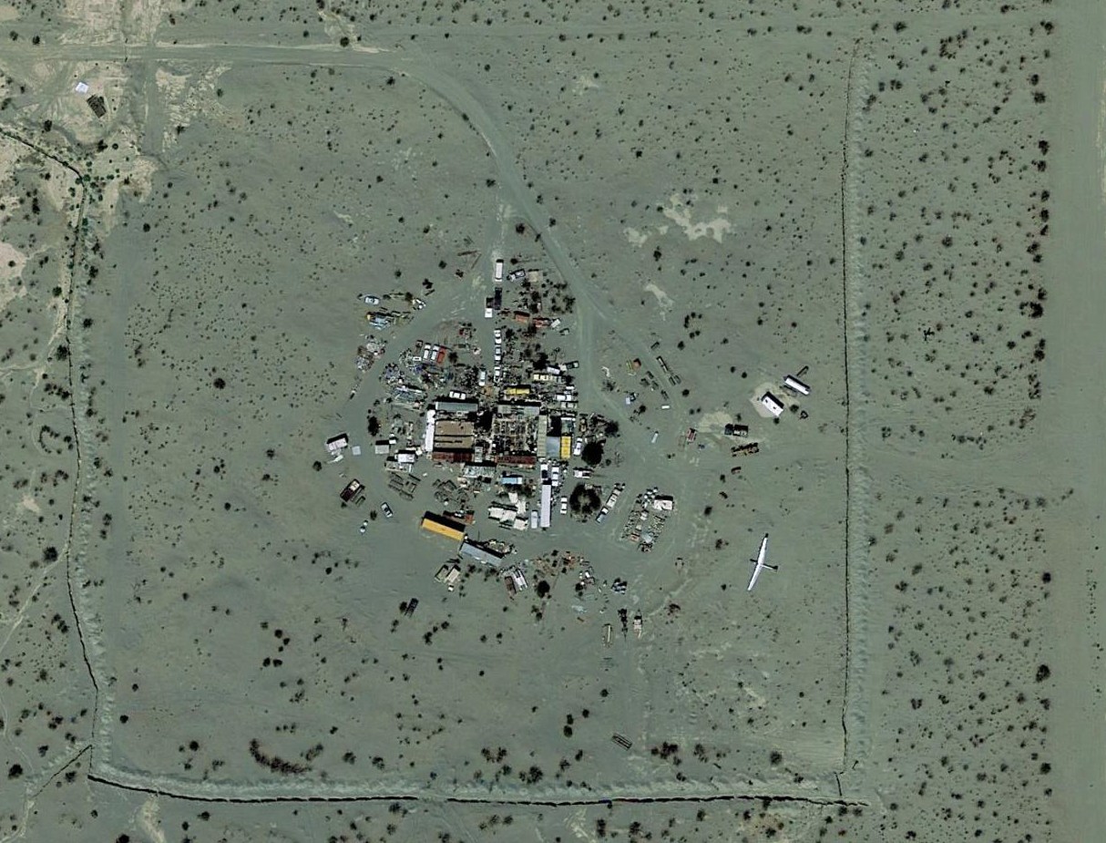
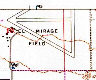
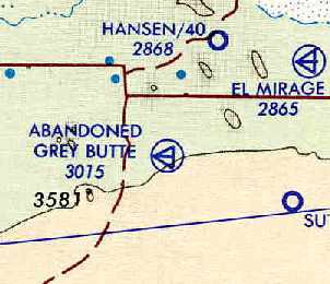
Victorville AAF Auxiliary #3 / El Mirage Airport (99CL), El Mirage, CA
34.624, -117.603 (East of Palmdale, CA)
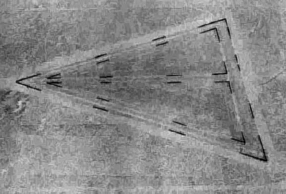
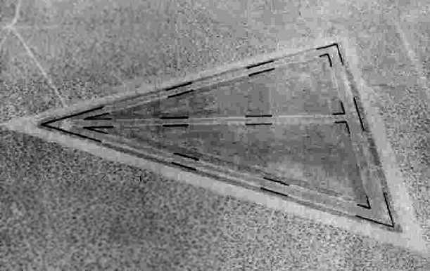
A 7/25/43 aerial view looking north at “Victorville AAF Auxiliary #3 (Mirage Field)”
from the 1945 AAF Airfield Directory (courtesy of Scott Murdock).
This airfield operated starting in 1942 as a satellite field for Victorville AAF (later renamed George AFB),
which participated in the 30,000 Pilot Training Program & later became a bombardier school.
The earliest depiction which has been located of this field
was a 7/25/43 aerial view from the 1945 AAF Airfield Directory (courtesy of Scott Murdock).
It depicted “Victorville AAF Auxiliary #3 (Mirage Field)” as having 4 paved runways.
According to John Voss, “Victorville AAF #3 (El Mirage)...
As this field was actually a dry lake bed Victorville AAF used it for the training of the pilots assigned to the Waco CG-4 glider program.”
El Mirage Field was not yet depicted on the February 1944 LA Sectional Chart.
The 1944 US Army/Navy Directory of Airfields (courtesy of Ken Mercer)
described "Mirage Aux. #3, Army" as having a 3,700' hard-surface runway,
and the remarks included, "Auxiliary to Victorville AAF."
The 1945 AAF Airfield Directory (courtesy of Scott Murdock) described “Victorville AAF Auxiliary #3 (Mirage Field)”
as a 640 acre square-shaped property having 4 bituminous runways, the longest being the north/south, ENE/WSW, and WNW/ESE 3,653' strips.
The field was not said to have any hangars, to be owned by the U.S. Government, and operated by the Army Air Forces.

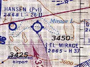
The earliest aeronautical chart depiction which has been located of El Mirage Field was on the March 1945 LA Sectional Chart.
It depicted "Mirage #3" as an auxiliary airfield.
El Mirage served as a satellite field for Victorville AAF until the end of WW2.
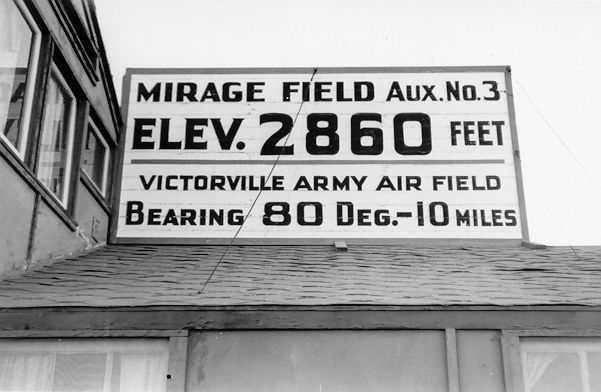
A 1947 photo by Jim Carr of the sign at El Mirage Field (courtesy of Cameron Scott).
Cameron Scott recalled, “My parents spent every weekend at the El Mirage Airfield from, the Time Gus Briegleb bought it.”
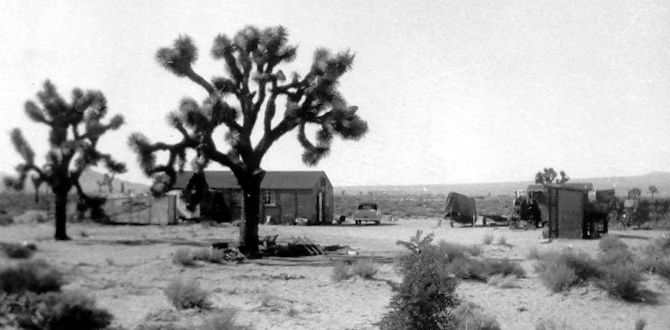
A 1948 photo by Jim Carr of the El Mirage Field bunkhouse (courtesy of Cameron Scott).
A 1949 color aerial view by Jim Carr looking northeast at El Mirage Field (courtesy of Cameron Scott),
showing 3 asphalt runways, and a yellow light single-engine plane on final approach at bottom-center.
A 6/1/52 USGS aerial view appeared to show the El Mirage Airfield in an abandoned state.
After WW2, the field was reused as a civil airfield.
Sailplane pilot Bill Berle reported that "I believe Gus Briegleb bought it as war surplus & started training in gliders in the 1950s."
El Mirage was depicted as a civil airport on the 1960 LA Sectional Chart (courtesy of Chris Kennedy).
It was described as having a 3,700' hard-surface runway.
Joe Kohler recalled, “One day after work [circa 1966-74] I drove from Grey Butte to El Mirage Airport
and had my first instruction in a Schweizer TG-32 sale plane.
During my sailplane training the instructor cut loose from the tow plane at about 1,000' AGL & said 'OK, what do you do now?'
I landed on El Mirage Dry Lake, proud that I passed a critical test on my way to soloing.
The instructor got out & hooked us back up to the tow rope & when the Fairchild PT-23 gunned his motor to begin the takeoff roll,
a cloud of alkali dust blew up & totally obscured any vision I had from the front seat of the 1947 Schweizer TG-32.
After what seemed like an hour the sailplane got out of the dusty ground effect & I finished the training for the day.
I eventually soloed at El Mirage in a Schweizer 1-26.”
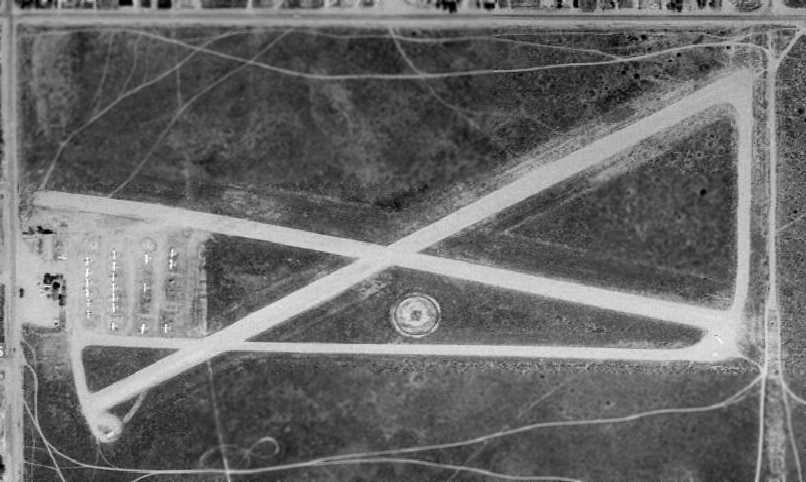
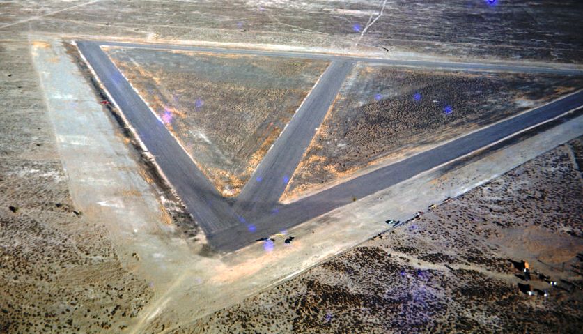
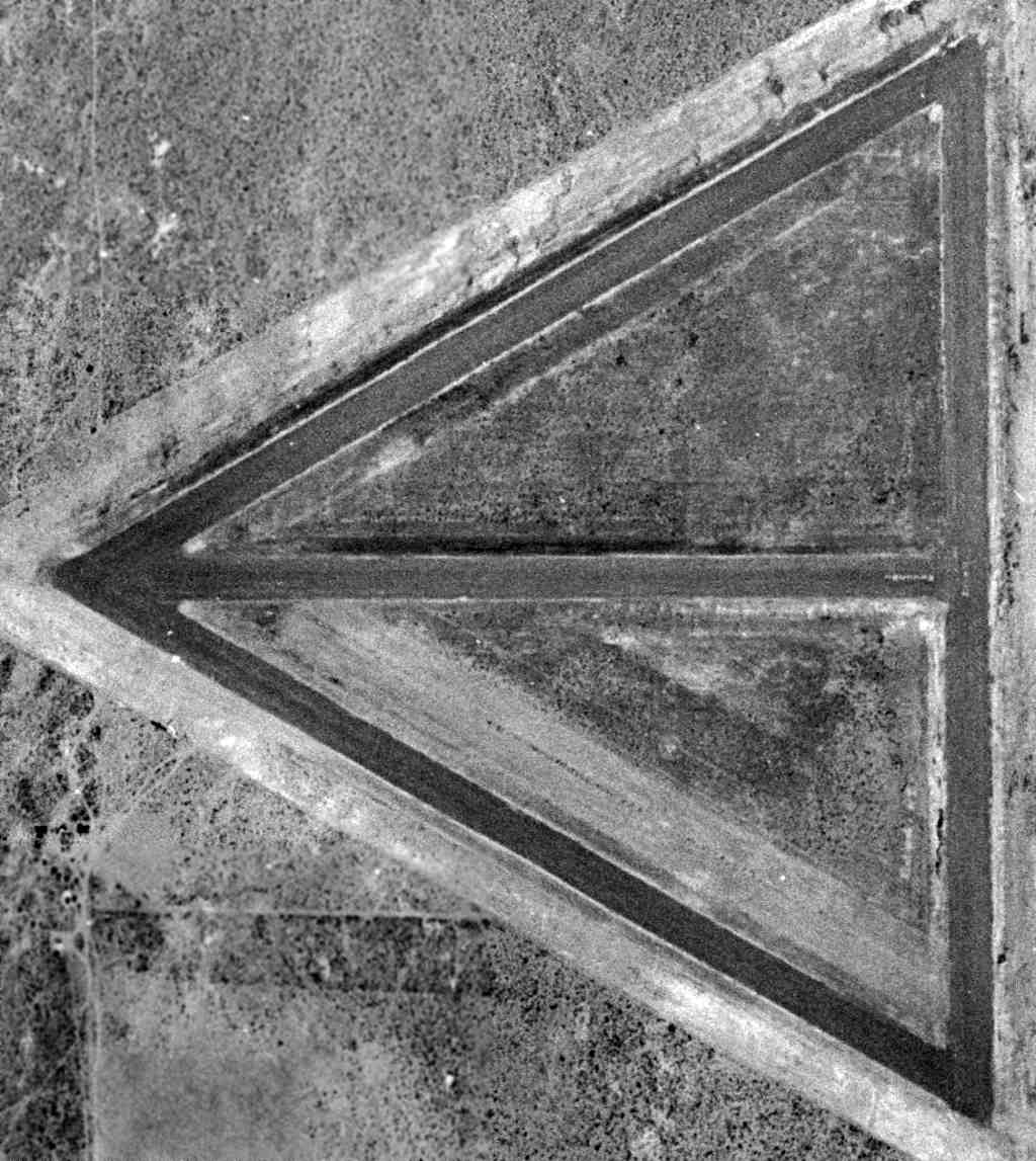
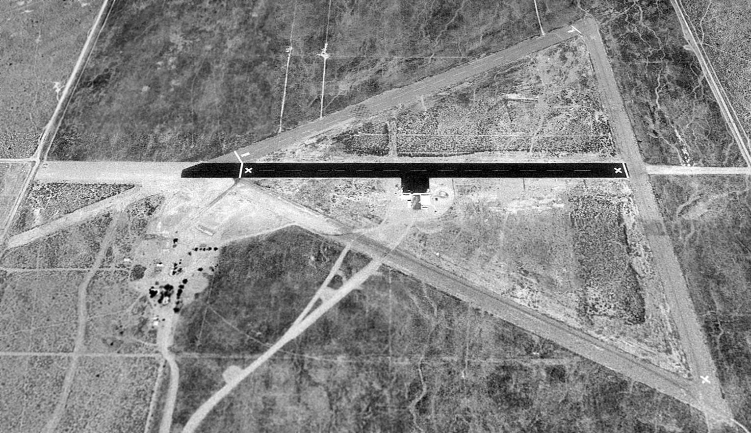
A 1968 aerial view depicted El Mirage Airport in its original (WW2) configuration, with 4 paved runways.
A closeup from the 1968 aerial view, showing gliders & other general aviation aircraft parked on the southwest side of El Mirage Airport.
The 1968 USGS topo map depicted El Mirage Field as having 4 paved runways.
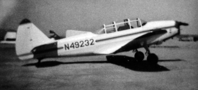
A 1970 photo of N49232, a 1943 Fairchild M-62A, C/N: T43-5055, at El Mirage Field.
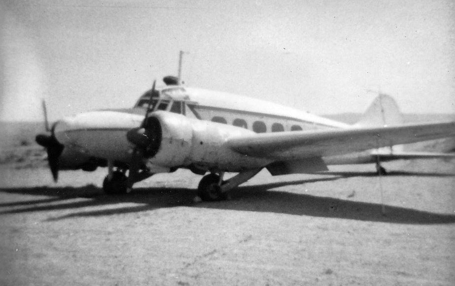
A 1970 photo of a 1949 Avro 652A Anson C.19 Series 2 at El Mirage Field.
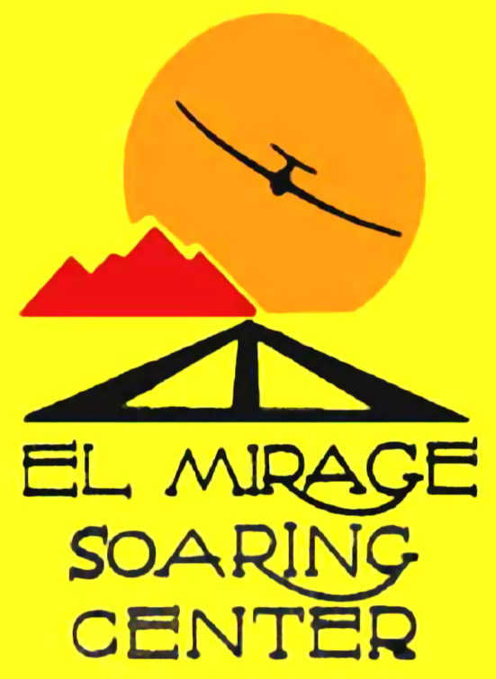
An undated logo of the El Mirage Soaring Center.
In Bill Berle's words, "Although many of the abandoned airfields have interesting histories,
El Mirage is a standout by any measure.
It was one of the greatest soaring sites in the USA,
home to many regional & national competitions.
A particular local weather phenomenon (the El Mirage "shear line"),
added to the already great high desert soaring conditions,
made it a launching point for many speed & distance records.
Gus Briegleb.... reportedly bought, disassembled, and reassembled on his property the old Pancho Barnes hangar.
El Mirage was another "home away from home" for many Edwards AFB test pilots interested in soaring,
including the ornery but brilliant chief of NACA Paul Bikle."
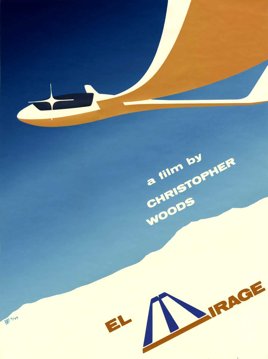
The cover of the evocative 1977 film “El Mirage” by Christopher Woods (courtesy of Collin Gyenes).
According to the film, “In 1976, Chris Woods, then a student at the California Institute of the Fine Arts Film School,
made this short documentary during the 43rd US Unlimited Class Soaring Nationals held at the storied El Mirage Glider Port in California's Mojave Desert.
The nostalgic images in this film have become a time capsule from one of the greatest soaring sites in America that ceased operations in the mid-1980s.”
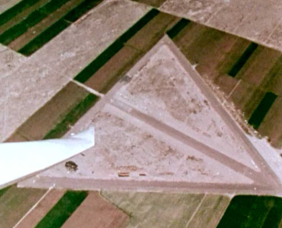
An aerial view looking southeast at El Mirage from a glider, from the 1977 film “El Mirage” by Christopher Woods (courtesy of Collin Gyenes).
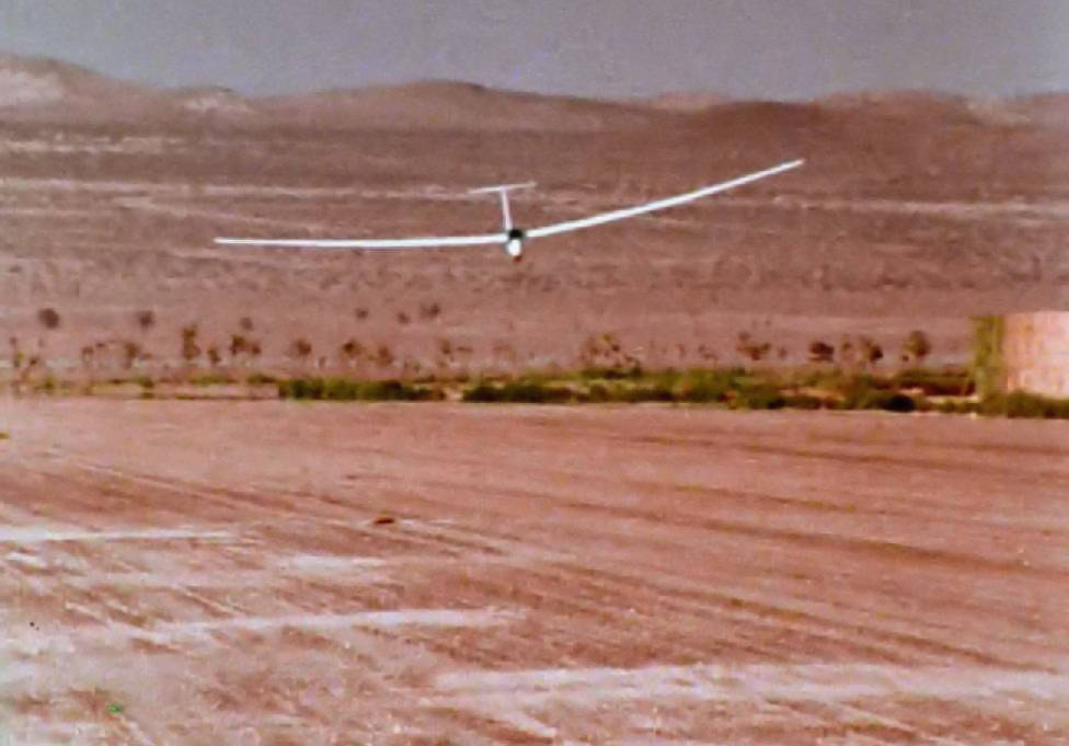
A glider landing at El Mirage, from the 1977 film “El Mirage” by Christopher Woods (courtesy of Collin Gyenes).
A 4/28/79 photo by Charles Smith of the 1976 Cessna 150M which he flew to El Mirage,
with beautiful snow-peaked mountains in the background.
Charles Smith reported, “At El Mirage in May 1979 the B-29 'Fertile Myrtle' was temporarily based there for the filming of Disney's 'Last Flight of Noah's Ark'.
It was during that time that I discovered El Mirage. I don't remember why I first landed there, probably just airport hopping,
but I do recall being fascinated by the folks who were landing on the adjacent dry lakebed.
My stop there was in a Cessna 150, when I learned about the B-29 arriving. I think there was a small cafe then, but can't swear to it. Maybe it was some vending machines.”
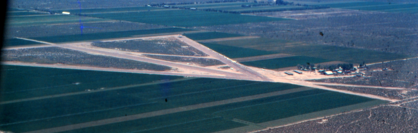
A 5/4/79 aerial view by Charles Smith looking southeast at El Mirage Field, with the B-29 parked at the southeast runway end (top-center of photo).
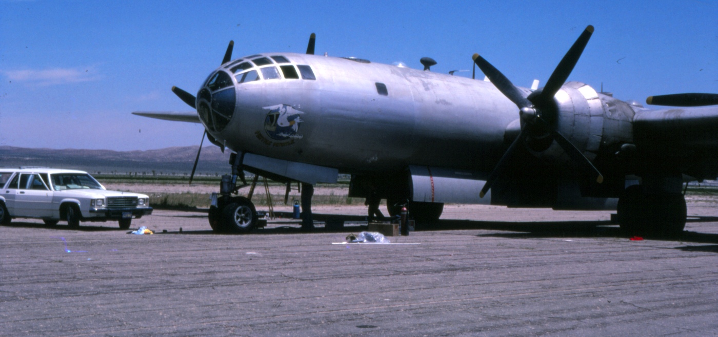
A 5/4/79 photo by Charles Smith of the B-29 'Fertile Myrtle' used at El Mirage for the filming of the Disney movie “Last Flight of Noah's Ark”.
Charles recalled, “While taking my mom & dad on their first couple of flights, I just happened to make El Mirage a destination, where we discovered the bomber & hangar for the Disney film.
It was a fun field to stop in at and hang around for a while.”

A 5/4/79 photo by Charles Smith of gliders on El Mirage Field, with the B-29 'Fertile Myrtle' visible at the end of the runway.
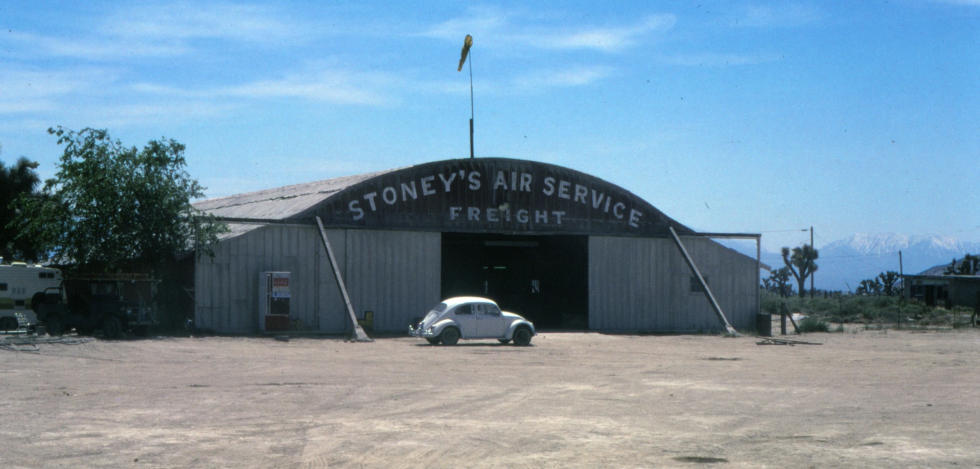
A 5/4/79 photo by Charles Smith of the El Mirage Field hangar painted with “Stoney's Air Service Freight” for the filming of the Disney movie “Last Flight of Noah's Ark”.
Dan MacPherson reported, “The 'Stoney's Air Service' hangar at El Mirage is the Pancho Barnes happy Bottom Riding Club hangar, purchased & moved to El Mirage by Gus Briglieb.”
The August 1980 LA Terminal Aeronautical Chart (courtesy of Mitchell Hymowitz)
depicted El Mirage Airport as having 3 paved runways, with the longest being 3,700'.
Bill Berle reported that El Mirage remained active on one level or another as a sailplane training facility until late 1984 or early 1985,
when it was leased to General Atomics as their unmanned air vehicle flight test center.
A 1994 USGS aerial view looking north showed that General Atomics repaved the east/west runway with asphalt at some point between 1968-94,
and built a new complex of hangars with an asphalt ramp south of the middle of the east/west runway.
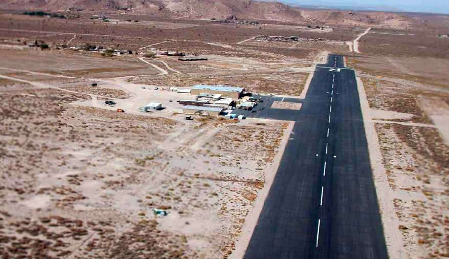
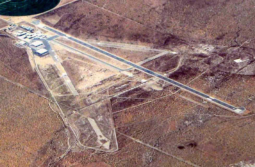
A circa 2000 aerial view looking west along El Mirage's runway.
For unknown reasons, General Atomics shifted their flight test operations in 2001 to Grey Butte.
Berle reported that El Mirage has returned to the control of the Briegleb family,
and they are trying to develop it as an airpark or some other civil use.
El Mirage Airport was listed in 2002 as for sale.
El Mirage was still listed (as of 2002) as an active private airfield.
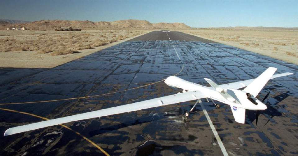
It appears as if El Mirage was still being used by General Atomics as of 2003,
as a 2003 NASA photo showed a General Atomics Altair unmanned aerial vehicle on an El Mirage runway.
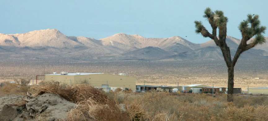
A 2003 photo by Tim Tyler of the hangars & buildings at the El Mirage airfield.
Time reported, “The access road off of El Mirage Road is called El Mirage Airport Road,
but the airfield area is now private property & called 'El Mirage Flight Test Facility',
with an 'Aeronautical Systems' sign up on the fence next to the gate,
which has a staffed guard shack just inside it.
The facility was about a third of a mile in to the north from the gate, on the edge of the dry lake.
I saw a large hangar, smaller hangar, and then around a dozen office trailers on site.
Top part of a mesh SATCOM or RADAR dish seen on the far side of the smaller hangar,
and a small, olive-drab or dark gray Nike LOPAR type radar unit on a trailer.
Off in the distance on a ridgeline on the far north side of the dry lake
I could see a small white structure that seemed to have one or two radomes visible.
It may or may not have anything to do with the aircraft RDT&E site."
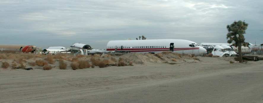
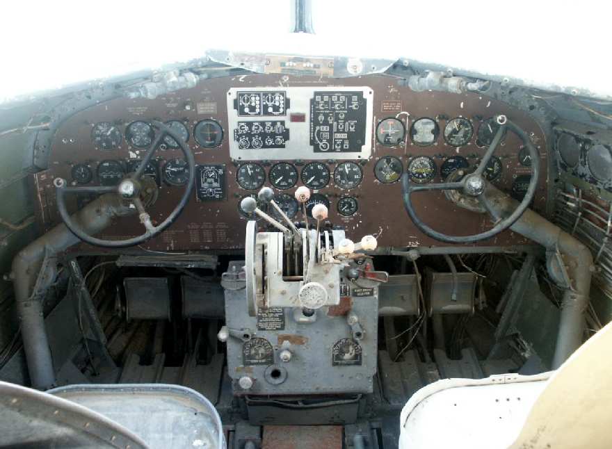
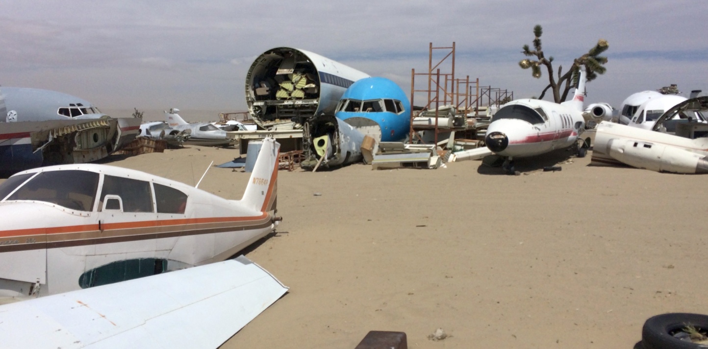
A 2003 photo by Tim Tyler of the remains of several Boeing airliners (707, 727, 747) at Aviation Warehouse.
Tim reported, "Just prior to Aeronautical Systems El Mirage Flight Test Facility gate
is Aviation Warehouse, Inc. & Thomson’s Aviation Manuals.
It’s basically an aircraft junkyard, with all sorts of civil airliner & private aircraft fuselages,
plus some parts of fighter aircraft in compounds on both sides of the road.
Mark Thomson, the owner, has a tidy business selling or leasing out fuselages
to movie producers who will use them for interior or exterior scenes,
especially if the script calls for the aircraft to be damaged or destroyed.
They provided the fuselage for the recent movie ‘SWAT’,
and some of the C-123 stuff used in ‘Con Air’, for example.
Fuselages are trucked up to Hollywood for filming.
He also has a large collection of aircraft manuals available for sale."
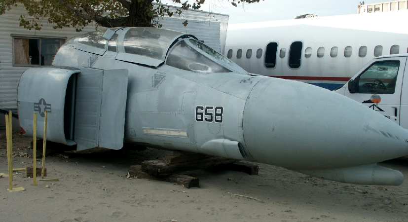
A 2003 photo by Tim Tyler of the forward fuselage of a Navy/USMC F-4 Phantom
(specific model undetermined) at Aviation Warehouse.
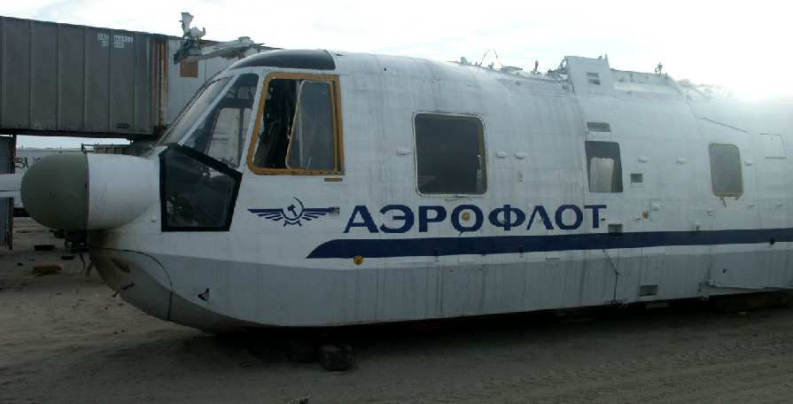
A 2003 photo by Tim Tyler of the fuselage of a Sikorsky S-61
(painted in "Aeroflot" colors, presumably for TV/movie work) at Aviation Warehouse.
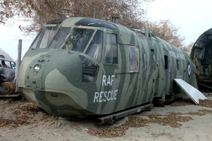
A 2003 photo by Tim Tyler of the fuselage of a Sikorsky S-61
(painted in "RAF Rescue" colors, presumably for TV/movie work) at Aviation Warehouse.
A 2003 photo by Tim Tyler of the cockpit of a vintage DC-3 airliner at Aviation Warehouse.
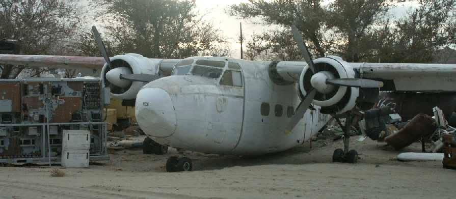
A 2003 photo by Tim Tyler of a rare British Hunting Percival Pembroke at Aviation Warehouse.
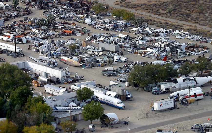
A 2003 aerial view of the Aviation Warehouse boneyard at El Mirage, © 2003 by Andy Martin (used by permission).
Aviation Warehouse specializes in providing aviation-related props for films.
This company has an estimated 100+ fuselage sections of aircraft, both civil & military.
The majority of the sections are from light aircraft but there are some other interesting examples, including:
Jetstar, B737, Sikorsky S64, DC-8, DC-3, UH-1, DC-130, F-4C, A-4A, CH-3E, Mi-24 Hind, P-2H, CH-21, and DC-6/7.
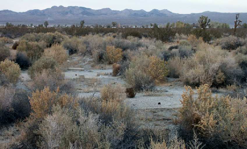
A 2003 photo by Tim Tyler of foundations which remain southwest of El Mirage.
Tim observed, "Southwest of the area, off El Mirage Road are several very old concrete foundations around a now empty field.
It may be the remains of barracks or other support structures for the former Auxiliary Airfield,
but they’re set back about 1.5 miles northeast of where I assume the field was."
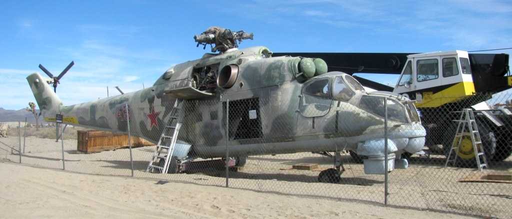
A 1/19/14 photo by Kurtis Clark of a Soviet Mil Mi-24 Hind attack helicopter at El Mirage Aviation Warehouse.
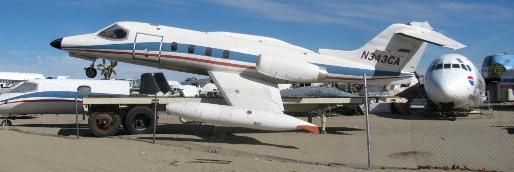
A 1/19/14 photo by Kurtis Clark of a Learjet mounted on a trailer as if in flight at El Mirage Aviation Warehouse.
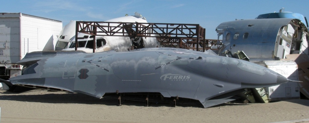
A 1/19/14 photo by Kurtis Clark of a mockup constructed for the Green Lantern movie of a fictional “Ferris Aircraft Sabre III” stealth drone at El Mirage Aviation Warehouse.
Sailplane pilot Bill Berle wrote a beautiful poem about El Mirage Airfield:
"REQUIEM FOR AN AIRFIELD, Bill Berle 8-11-84
Gone is the panic - the struggle in which it was born
Gone are the machines & the men
and though it lives on in a peaceful time
it slowly fights a losing battle for life
Without a sound
Stand on the fading, dying runways - walk among the dead metal bones
and you become very sad
A thousand ghosts are making plans to fight
a war only remembered
The creaking wood of buildings has somehow remained
against the forces bent on erasing their existence
Their doors & rafters cry for help
to the trees & the ears of those who do not listen - the end is near
Yet this place has only yesterday breathed of life
of the sights & sounds that made it special
A new era brought new machines, but the same breed of souls
and ironically it once again did as it was born to do
making pilots out of men
It sparkled with the love & reverence it deserved
and they came here, to challenge the sky
and ride the razor edge of sanity
in machines that whispered back at the ghosts
But now again it lies dying
not of age & wind, but loneliness
The world incessantly gnaws at its border
and the souls who care cannot look without tears
But I have been here, to this magic place
before it is ended
I have felt the emotion of its spirit, and mine has become stronger
It has given me a gift, and let me learn
and it can therefore never die . . . but
if only El Mirage could talk"
The 2015 LA Sectional Aeronautical Chart depicted El Mirage Airport as a private airfield having 3 paved runways, with the longest being 3,700'.
A 2016 aerial view looking north showed that General Atomics replaced El Mirage's east/west runway with a newly-built parallel east/west runway to the north,
and has continued to expand the number of buildings on the airfield.
A 5/15/17 photo by Matt Franklin of a variety of junked aircraft at the El Mirage Aviation Warehouse,
including a rare Hamburger Flugzeugbau HFB-320 Hansa Jet business jet, of which only 47 were produced.
____________________________________________________
Grey Butte Auxiliary Army Airfield #4 / Grey Butte Airport , Southwest of El Mirage, CA
34.565, -117.67 (East of Palmdale, CA)
A 7/25/43 aerial view looking north at “Victorville AAF Auxiliary #4 (Grey Butte Field)”
from the 1945 AAF Airfield Directory (courtesy of Scott Murdock).
This field started operations in 1942 as a satellite field for Victorville AAF,
which participated in the 30,000 Pilot Training Program & later became a bombardier school.
The earliest depiction which has been located of this field
was a 7/25/43 aerial view from the 1945 AAF Airfield Directory (courtesy of Scott Murdock).
It depicted “Victorville AAF Auxiliary #4 (Grey Butte Field)” as having 4 paved runways.
Grey Butte Field was not yet depicted on the February 1944 LA Sectional Chart.
The 1944 US Army/Navy Directory of Airfields (courtesy of Ken Mercer)
described "Grey Butte Aux. #4, Army" as having a 3,700' hard-surface runway,
and the remarks included, "Auxiliary to Victorville AAF."
Grey Butte was used by Marine aircrews from Mojave MCAS during 1944-45 for carrier landing practice,
during which time several Marine planes crashed.
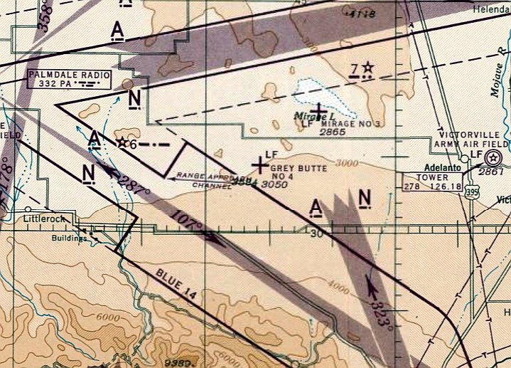
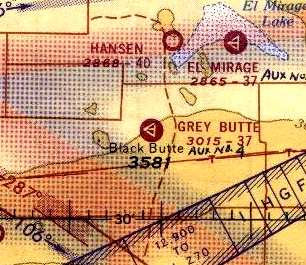
The earliest aeronautical chart depiction which has been located of Grey Butte Field was on the March 1945 LA Sectional Chart.
It depicted “Grey Butte #4” as an auxiliary airfield.
The 1945 AAF Airfield Directory (courtesy of Scott Murdock) described “Victorville AAF Auxiliary #4 (Grey Butte Field)”
as a 640 acre square-shaped property having 4 bituminous runways, the longest being the north/south, ENE/WSW, and WNW/ESE 3,653' strips.
The field was not said to have any hangars, to be owned by the U.S. Government, and operated by the Army Air Forces.
Grey Butte was abandoned by the military at some point between 1945-50.
After WW2, the field was reused for at least some period as a civil airfield.
Grey Butte was depicted as an active civil field on the 1950 LA Chart (according to Bob Cannon).
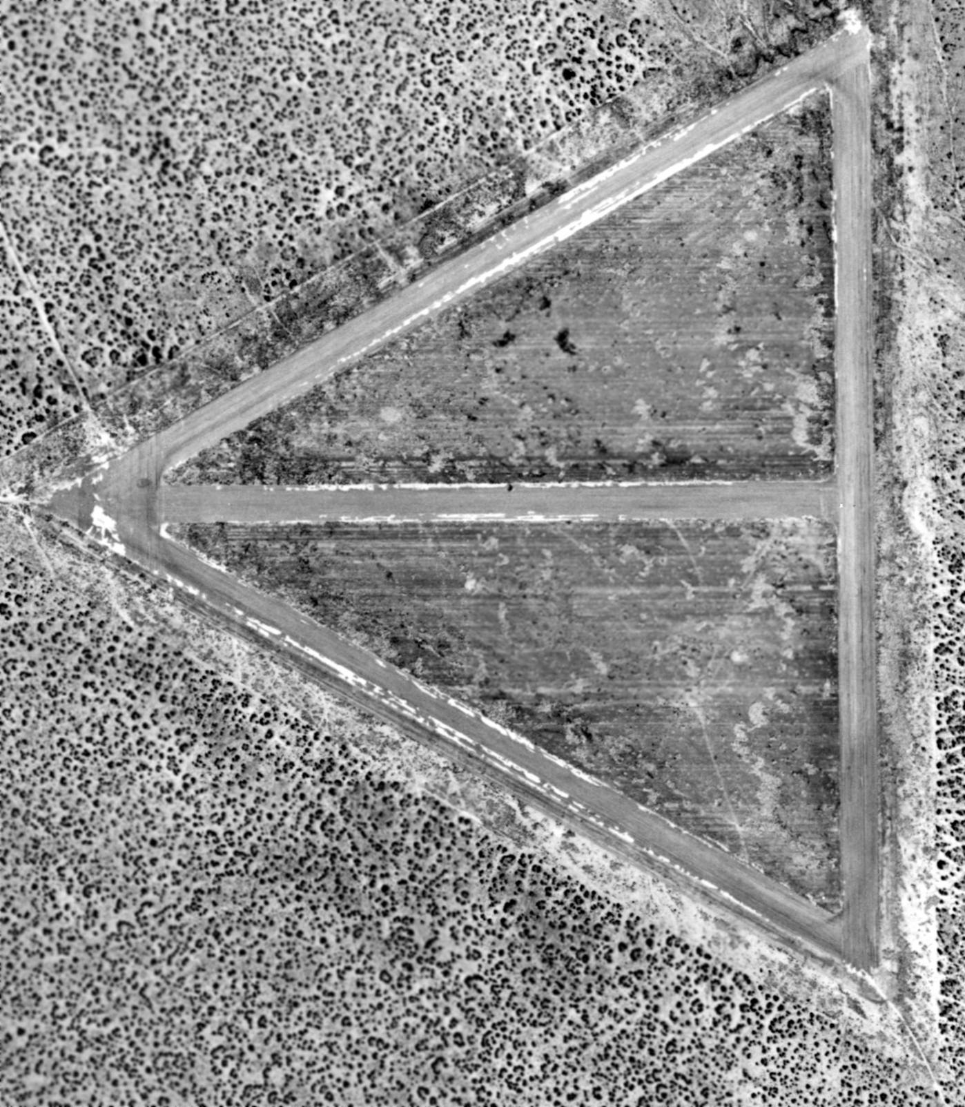
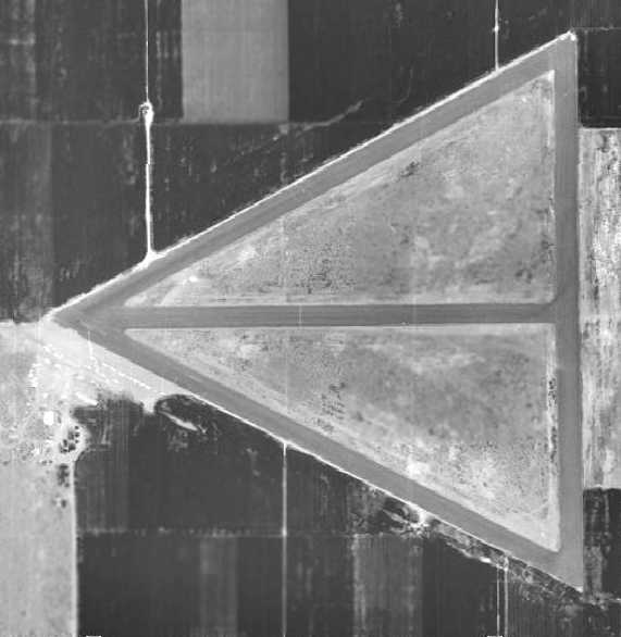
A 3/3/53 USGS aerial photo depicted Grey Butte Field in its original configuration, with 4 paved runways.
But there was no sign of any recent usage.
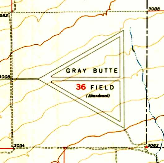
The 1956 USGS topo map depicted “Gray Butte Field (Abandoned)” as having 4 paved runways.
A 1959 aerial view showed the field in an unchanged configuration.
The Grey Butte airfield was evidently closed at some point between 1950-60,
as it was depicted as "Abandoned airport" on the 1960 LA Sectional Chart (courtesy of Chris Kennedy).
Tom Pinard recalled, “In 1961-63, Grey Butte was home to a 'borate' air tanker operation.
Two pilots & a mechanic were based out of Grey Butte, living in Wrightwood.
I published & edited the weekly newspaper in Wrightwood. I did a feature story on our borate pilots.
They flew a TBM off Grey Butte's runways; they had a water reservoir that was fashioned in a long trench.
The guys, with nothing to do while waiting for a fire alert, actually figured out how to water-ski down the long trench, pulled by an old station wagon.
Al Adolph & Harry Bernier were the pilots.”
Grey Butte was once again depicted as an active civil airfield on the 1964 LA Sectional Chart.
The Aerodromes table on the chart described the field as having 3 runways,
with the longest being a 3,740' bituminous strip.
Grey Butte was still depicted as an active airfield on the 1965 LA Local Area aeronautical chart (courtesy of John Voss).
At some point before 1968, the distinctive pattern of runways of the WW2-era Army airfield
were reused by McDonnell Douglas as an aircraft radar cross section testing range.
It is the oldest of the Mojave Desert RCS ranges.
Joe Kohler recalled, “I went to work for Douglas Aircraft Company in Santa Monica.
The Microwave Lab section in Santa Monica had a respectable indoor anechoic chamber.
At the same time the Microwave Lab had an outdoor radar test range on Rosamond Dry Lake courtesy of the USAF.
As the importance of radar cross-section data began to grow,
the Douglas management decided to move to a site that was a little more weather proof & could be under 100% Douglas control.
Grey Butte Airport was the place.
I worked for Douglas from 1966-74 & spent a number of years stationed at the Grey Butte site as an antenna (and RCS) test engineer.
The pictures have brought back fond memories of my early engineering days
as well as a stoic reminder of the extent this country went to during the Cold War to protect ourselves.”
After getting a power [pilots] license, I flew to work at Grey Butte a couple of times.”
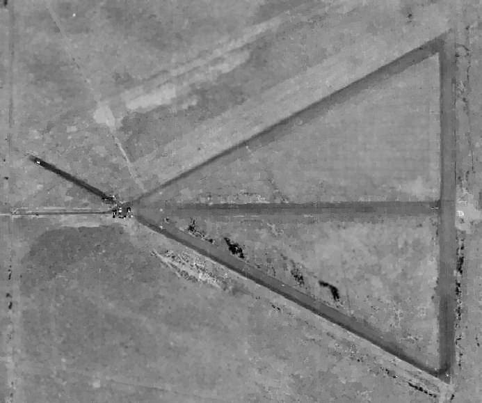
A 1968 aerial photo showed that radar cross-section testing gear had been erected
on the runway intersection on the west side of the field at some point between 1953-68,
and each end of the runways had been painted with a closed “X” symbol.
The Grey Butte airfield was labeled "Abandoned" on the September 1971 USAF Tactical Pilotage Chart (courtesy of Chris Kennedy).
A 1974 aerial view showed that the scope of the radar cross-section testing gear on the west side of the airfield
had increased somewhat compared to the 1968 photo.
The Grey Butte radar cross-section testing range was used in 1975
to test a full-scale model of the Lockheed F-117 Stealth Fighter.
The August 1980 LA Terminal Aeronautical Chart (courtesy of Mitchell Hymowitz) depicted Grey Butte as an abandoned airfield.
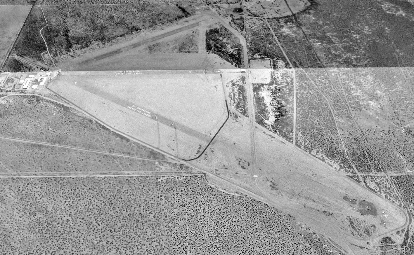
A 1994 USGS aerial view looking north at Grey Butte showed "No Trespassing - Unsafe For Landing" had been painted 3 times along the former runways.
The northwest/southeast runway appeared to be in the process of being extended significantly to the southeast.
A circa late 1990s aerial view looking south at Grey Butte.
Grey Butte's RCS range was shut down in the late 1990s.
Control of the site passed to General Atomics in mid 2001,
which also operates unmanned aerial vehicle flight testing operations from nearby El Mirage.
Tim Tyler visited Grey Butte in 2003, and reported that it is "Now another [General Atomics] Aeronautical Systems site.
I pulled right up to the gate & got out of the car to talk to the guard.
The guard explained the site was a McDonnell Douglas test facility,
but it was now used by General Atomics for RQ-1A (the new ‘B’ version Predator) research, design, testing & evaluation.
He also volunteered that General Atomics Aeronautical Systems operates the former El Mirage Dry Lake site,
though I failed to ask why General Atomics is using 2 similar sites, only about 10 miles apart.
He advised that there weren’t any structures left from the Army Auxiliary Airfield days,
but that there apparently were some 'pits' far back on the property that may have had something to do with bombs.
Predators fly out of the site on pretty much a daily basis -
one had just been up a few hours prior to my arrival,
and they often will fly over the El Mirage Dry Lake."
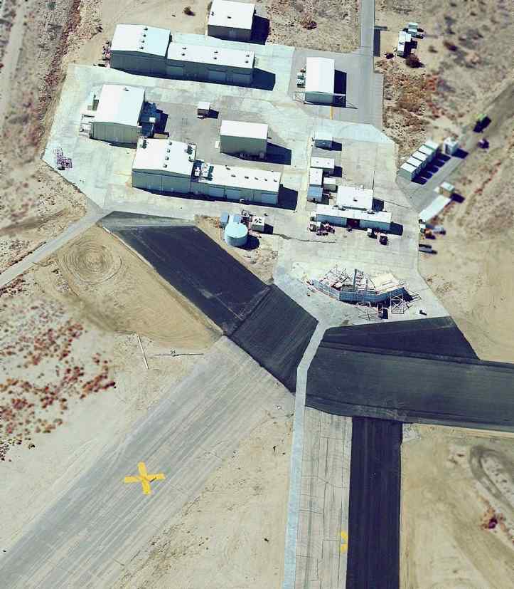
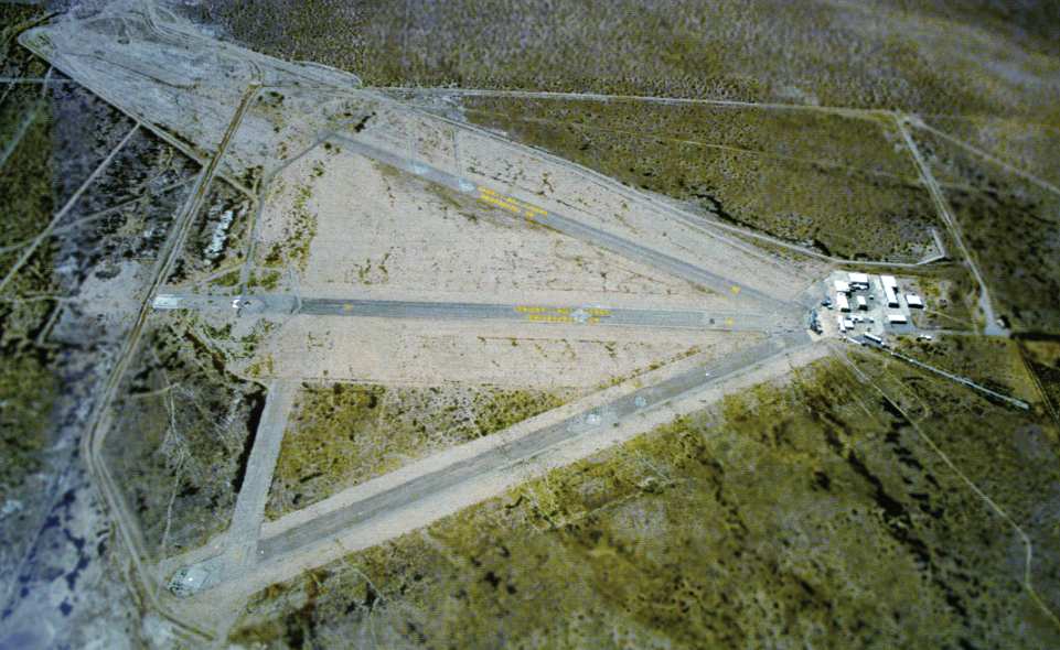
A circa 2005 aerial view looking west at the buildings at the west end of the Grey Butte airfield.
The gantry previously used for radar cross section testing is at the left.
The other buildings appear to be hangars, used for UAV flight operations.
A circa 2005 aerial view looking east at the remains of a radar cross section testing pylon mounting,
on the east end of the former east/west runway at Grey Butte.
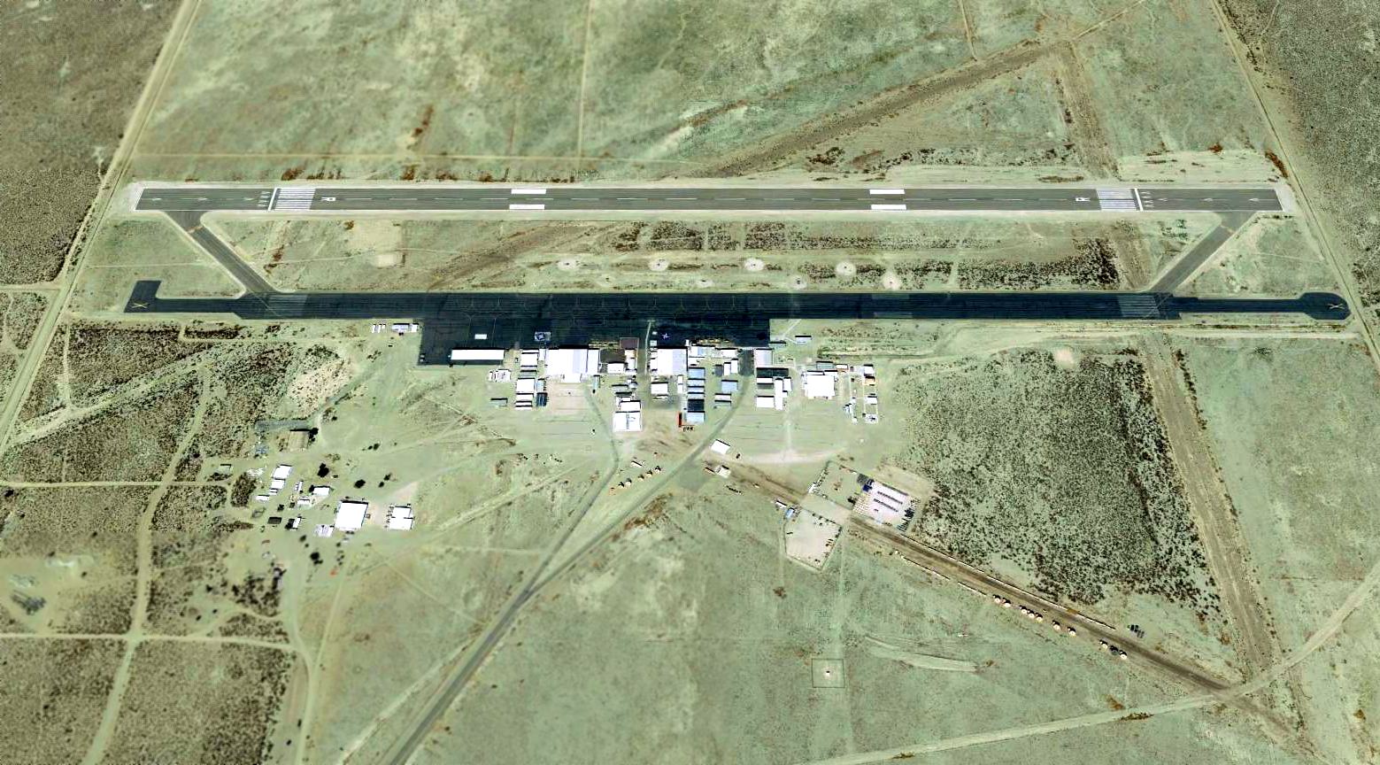
A 6/14/11 aerial view looking northwest at Grey Butte,
showing the modern east/west runway laid over the remains of the WW2 airfield.
The 2015 LA Sectional Aeronautical Chart depicted Gray Butte as a private airfield having an 8,000' paved east/west runway.

A 2016 aerial view looking north showed Gray Butte's lengthened northwest/southeast runway had been abandoned,
and a new parallel east/west runway had been built to the north of the original east/west runway.
Thanks to Walt Witherspoon for information about Grey Butte.
____________________________________________________
____________________________________________________
This site covers airfields in all 50 states.