
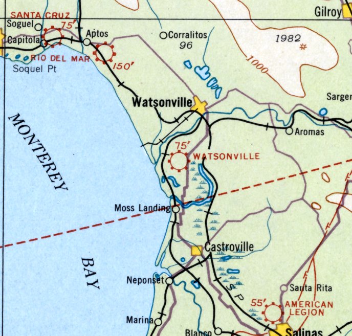
Abandoned & Little-Known Airfields:
California: Monterey area
© 2002, © 2024 by Paul Freeman. Revised 5/2/24.
This site covers airfields in all 50 states: Click here for the site's main menu.
For the 6th year, the CA pages of this website are sponsored by the California Pilots Association:
____________________________________________________
Please consider a financial contribution to support the continued growth & operation of this site.
American Legion Airport / Remco Flying Field (revised 1/25/21) - Carmel Valley Vintage Airfield (revised 5/2/24)
(Original) Fort Ord AAF / South Parade Ground AAF (revised 8/5/19) - Santa Cruz - Capitola Airport (revised 7/10/22)
Santa Cruz Skypark (revised 1/25/21) - (Original) Watsonville Airport (revised 5/2/24)
____________________________________________________
American Legion Airport / Remco Flying Field, Salinas, CA
36.704, -121.657 (Southeast of San Jose, CA)
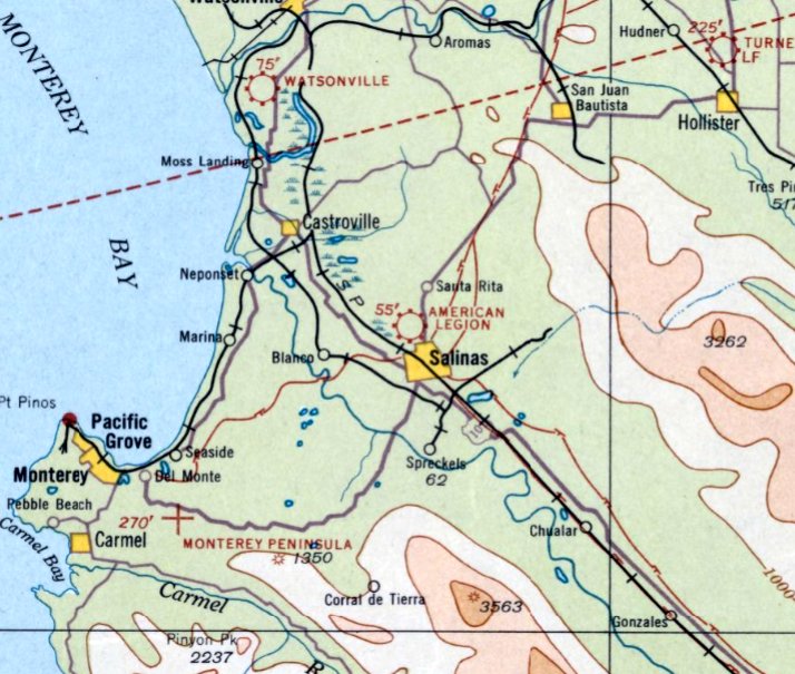
American Legion Airport, as depicted on the May 1933 San Francisco Sectional Chart.
The date of establishment of American Legion Airport has not been determined.
The earliest depiction which has been located of American Legion Airport was on the May 1933 San Francisco Sectional Chart,
which depicted American Legion Airport as a commercial/municipal airport.
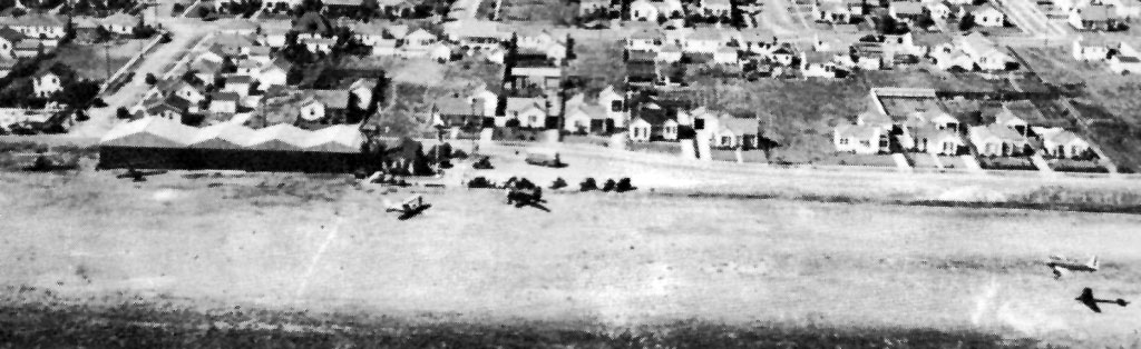
The earliest photo which has been located of American Legion Airport was a 1939-40 aerial view (courtesy of Bruce Baker)
showing 5 single-engine aircraft & a row of hangars on the side of an unpaved airfield.
The April 1941 San Francisco Sectional Chart (courtesy of Paul Columbus) depicted American Legion as a commercial/municipal airport.

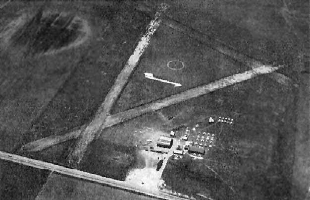
A 11/22/41 aerial view of American Legion Airport (from the UCSB Library)
depicted the field as having an east/west unpaved runway, with a single building & 1 light single-engine aircraft on the northeast side.
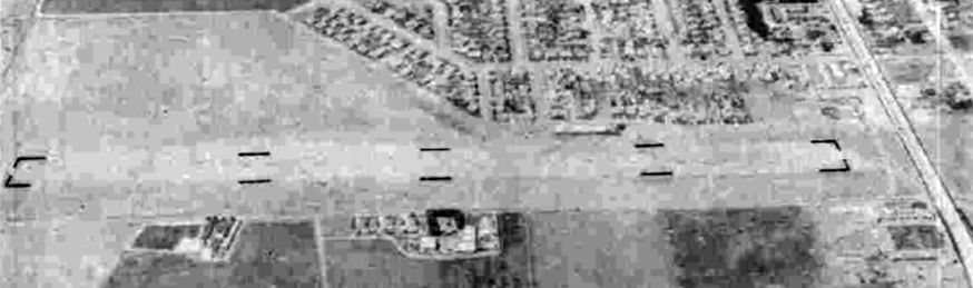
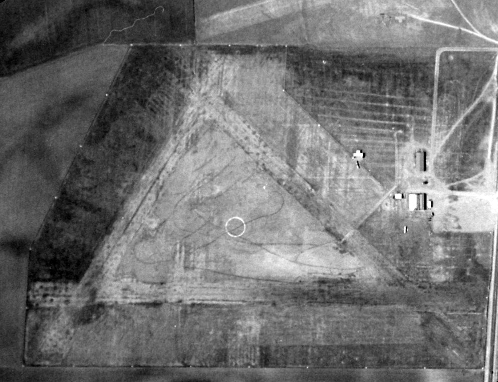
American Legion Airport, as depicted on a 7/30/43 aerial view looking north from the 1945 AAF Airfield Directory (courtesy of Scott Murdock)
depicted American Legion Airport as having an east/west unpaved runway, with a single building on the northeast side.
The 1945 AAF Airfield Directory (courtesy of Scott Murdock) described American Legion Airport
as a 60 acre irregularly-shaped property having 2 oiled runways, measuring 3,000' east/west & 2,500' northwest/southeast.
The field was said to have 3 metal hangars, the largest being a 60' x 40' structure.
American Legion Airport was described as being owned by the City of Salinas, and operated by private interests.
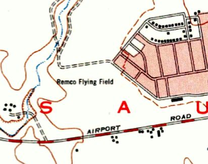
The airfield was evidently renamed “Remco Flying Field” at some point between 1945-47, as that is how it was labeled on the 1947 1:24k USGS topo map.
It depicted an open area with a single building on the northeast side, bounded by Airport Road along the south.
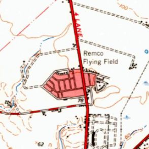
In 1947 the Remco Flying Field may have been relocated a half-mile to the northeast to the east side of Main Street,
as that is where the 1947 1:64.5k USGS topo map labeled the field,
and the original location of the field on the west side of Main Street was depicted as an empty area.
Or this may have simply been an error on the part of the map makers.
The last aeronautical chart depiction which has been located of American Legion Airport was on the February 1947 San Francisco Sectional Chart.
Note that its depiction had been downgraded to an auxiliary airfield,
probably due to the fact that the much larger Salinas AAF to the southeast had been released for civilian use as the new Salinas Airport.
American Legion Airport was evidently closed at some point in 1947 (presumably when the much larger Salinas AAF to the southeast was released for civilian use),
as it was no longer depicted on the August 1947 San Francisco Sectional Chart.
A 1956 aerial photo showed houses & a school had covered the Remco Flying Field location on the west side of Main Street.
The 1970 USGS topo map showed the Santa Lucia School having been built over the Remco Flying Field location on the west side of Main Street,
and the North Salinas High School having been built over the Remco Flying Field location on the east side of Main Street.
Reportedly West Laurel Drive was built over the American Legion Airport runway.
Bruce Baker reported, “I have driven down that runway all my life & never knew that Laural Drive was a runway at one time!”
The 1998 USGS aerial photo depicted no remaining trace of the airfield,
with the area having been densely filled with housing & schools.
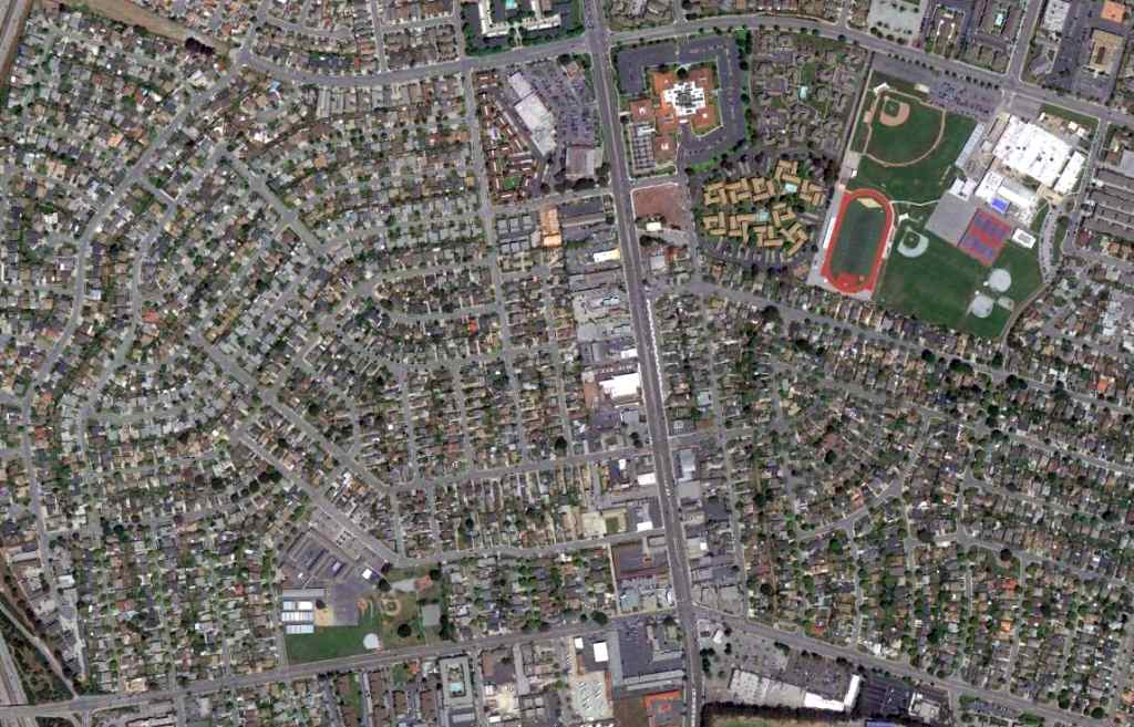
A 5/5/12 aerial view depicted no trace remaining of American Legion Airport / Remco Flying Field.
The site of All American Airport is located at the intersection of West Curtiss Street & North 4th Street.
A few other streets in the neighborhood commemorate the airport, such as Boeing Avenue & Douglas Avenue.
____________________________________________________
(Original) Fort Ord Army Airfield / South Parade Ground Army Airfield, Marina, CA
36.65, -121.807 (Southeast of San Jose, CA)
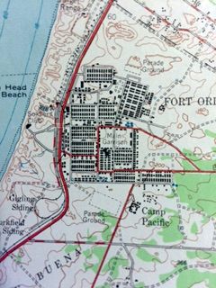
The outline of the original Fort Ord AAF was depicted on the 1947 USGS topo map (courtesy of Kevin Walsh),
but it was labeled as “Parade Ground”.
The original airfield for the Army's Fort Ord was located in the main garrison area of the base.
The date of establishment of the original Fort Ord Army Airfield has not been determined.
It was not yet listed among active airfields in the 1945 AAF Airfield Directory (courtesy of Scott Murdock).
The 1947 USGS topo map (courtesy of Kevin Walsh) depicted the rectangular outline of what eventually became the Fort Ord Army Airfield, but labeled it as “Parade Ground”.
According to an article in the September 2006 issue of the CA State University Monterey Bay “Campus Connection” (courtesy of Rex Ricks),
the airfield began operation in the 1940s.
It had a short runway, which was used for Army airplanes (& eventually helicopters).
The Fort Ord Army Airfield may have not been in official operation during the 1940s though,
as it was not yet depicted at all on the February 1949 San Francisco Sectional Chart (according to Chris Kennedy).
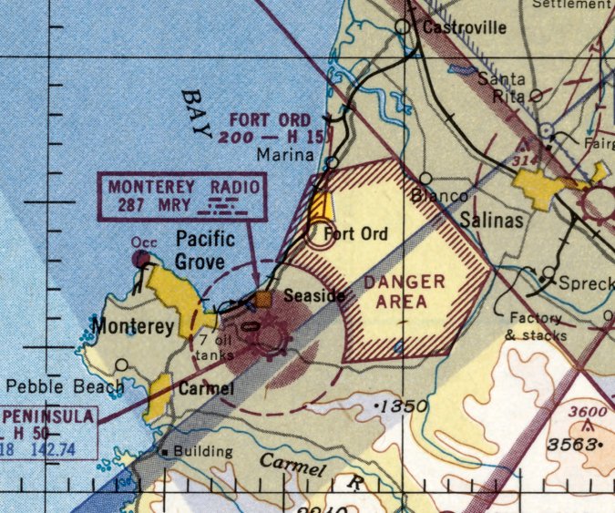
The earliest aeronautical chart depiction which has been located of the Fort Ord AAF was on the March 1951 San Francisco Sectional Chart.
It depicted Fort Ord AAF as having a 1,500' hard-surface runway.
Jonathan Westerling reported, “The 1951 Airman's Information Manual was the first to list the original Fort Ord Airfield as being closed to any aircraft except 'L-type' or smaller.
This terminology was used post-WW2 to refer to liaison aircraft like the Stinson L-5 Sentinel & Cessna L-19 Bird Dog.”
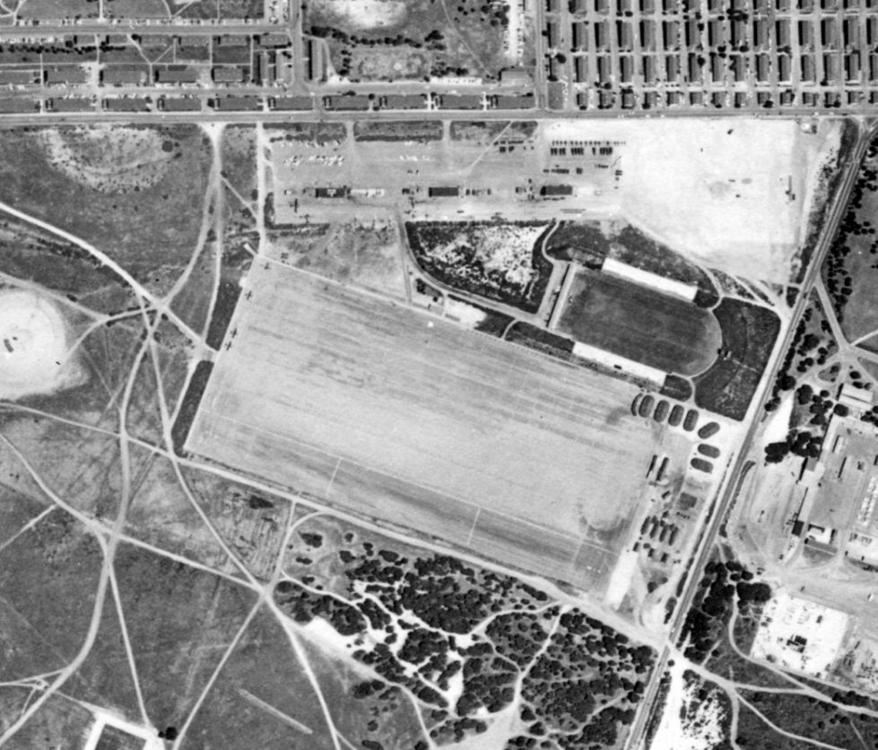
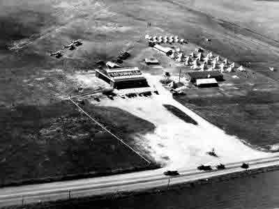
The earliest photo which has been located of the Fort Ord AAF (& the only photo showing aircraft on the field) was a 5/14/56 aerial view (from the UCSB Library).
It depicted Fort Ord AAF as having a short paved northwest/southeast runway, with 5 light single-engine aircraft on the northwest side of the runway & on the ramp on the northwest side.
A larger airfield Fort Ord Airfield was constructed at some point between 1956-60 several miles to the northeast,
the 1960 San Francisco Sectional Chart (courtesy of Jonathan Westerling) depicted the original airfield as “Abandoned airport”.
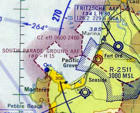
The original Fort Ord Army Airfield was evidently reopened (very briefly) at some point between 1960-63 as South Parade Ground Army Airfield,
as that is how it was labeled on the June 1963 San Francisco Sectional Chart (courtesy of Chris Kennedy).
It depicted the field as having a 1,500' hard-surface runway.
The South Parade Ground Army Airfield was evidently closed at some point between 1963-64,
as it was no longer depicted at all on the June 1964 San Francisco Sectional Chart (according to Chris Kennedy).
According to an article in the September 2006 issue of the CA State University Monterey Bay “Campus Connection” (courtesy of Rex Ricks),
after the South Parade Ground Army Airfield was closed,
“the old aircraft maintenance hangars were relegated for use as a motor pool.
Later the site was converted to the South Parade Ground, where graduation ceremonies were held for trainees.”
The 1968 USGS topo map (courtesy of Rex Ricks) continued to depict the rectangular outline of the airfield area of the Fort Ord Army Airfield,
but did not label it as an airfield.
According to an article in the September 2006 issue of the CA State University Monterey Bay “Campus Connection” (courtesy of Rex Ricks),
Fort Ord was closed in 1994.
A 2005 aerial view looking west at the former runway & buildings at Ford Ord AAF.
According to an article in the September 2006 issue of the CA State University Monterey Bay “Campus Connection” (courtesy of Rex Ricks),
the last remnants of the former airfield (tie-downs & a few former hangars) were demolished in 2006.
Rex Ricks reported in 2007, “In its place is now a softball & baseball field.
Unfortunately, CSUMB has been mediocre at best at reutlizing & preserving some of the history that the Army left behind.”
A 2015 aerial view of the site of Ford Ord AAF.
The site of the original Fort Ord AAF is located southwest of the intersection of General Jim Moore Boulevard & 1st Street.
____________________________________________________
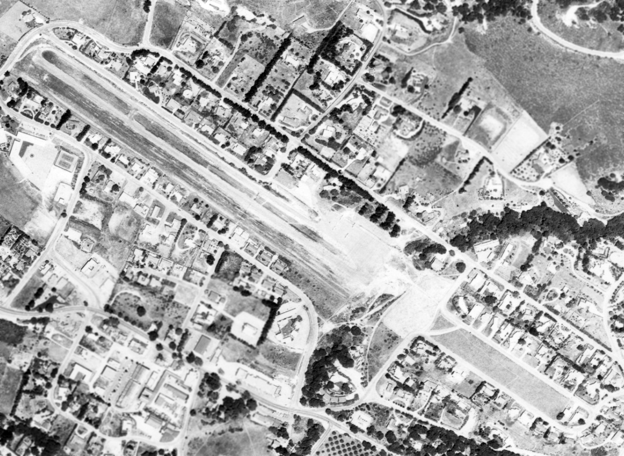
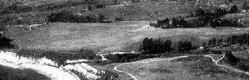
Carmel Valley Vintage Airfield (O62), Carmel Valley, CA
36.48, -121.73 (South of San Jose, CA)
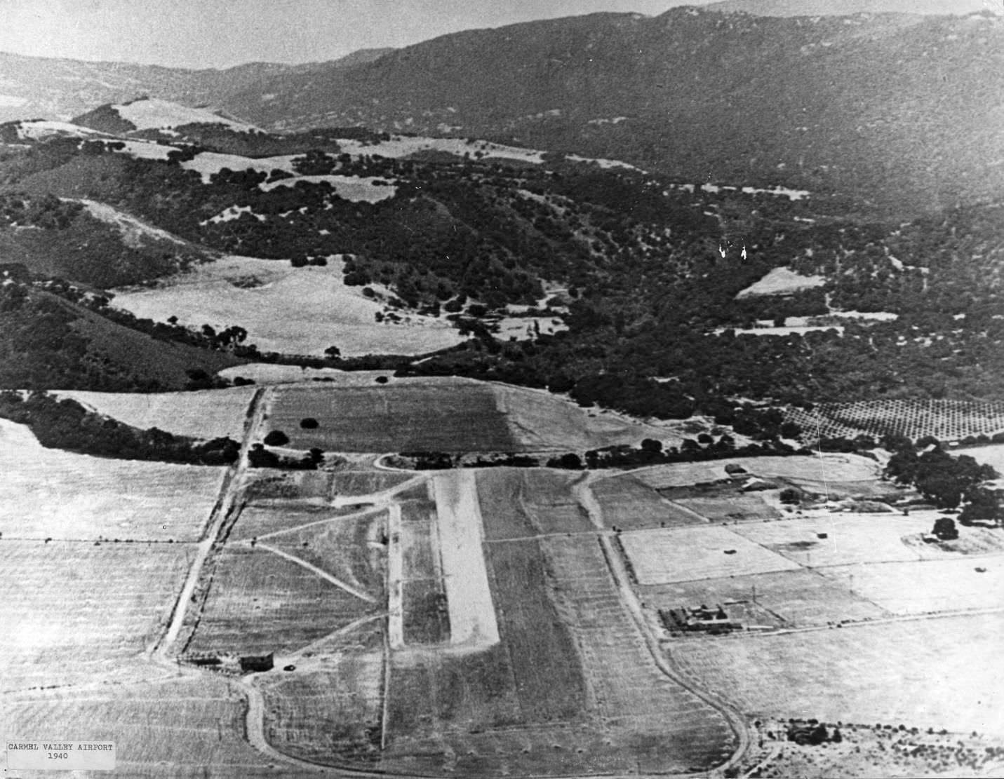
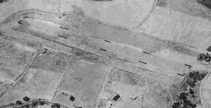
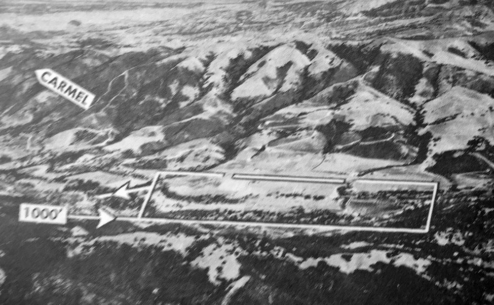
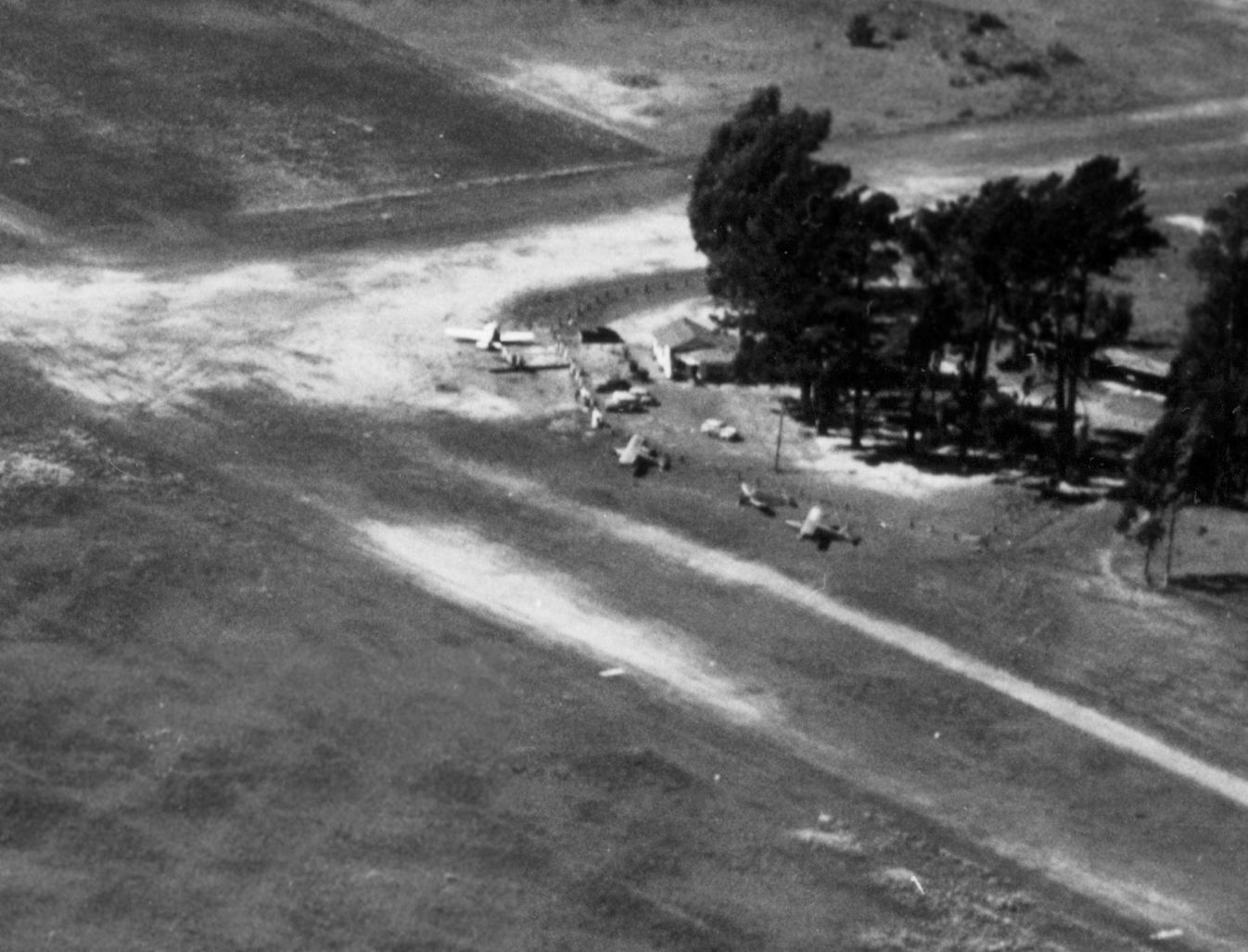
A circa 1940 aerial view looking southeast at the Carmel Valley Airfield (from a 2014 report by Jeff Ohlson for the Carmel Valley Historical Society),
with Tirey Ford's original hangar/home visible at lower-left.
In the late 1930s, local real estate developer Byington Ford bought the northeast corner of Rancho Las Laureles in the little town of Carmel Valley to establish an airpark.
He was convinced that mass production of small aircraft would put a plane within the reach of anyone who could afford a car.
Byington Ford developed a tailor-made project for pilot-owners who would want to be at home a minute or two after getting out of their planes.
The grassy piece of acreage he chose had served bush pilots for landings even before Ford identified it for his venture.
The planned strip enjoyed a "channel" wind up-valley all day long.
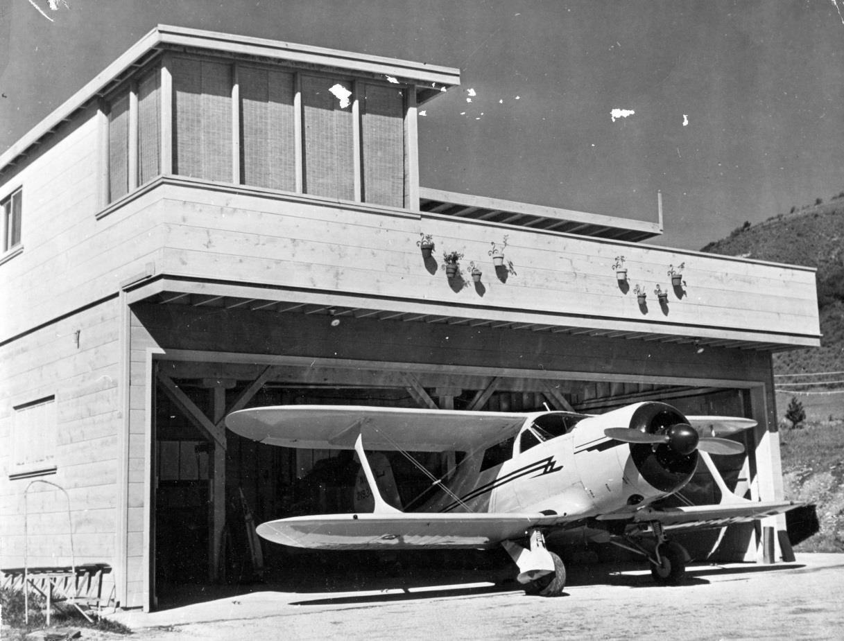
Ford recorded house lots adjacent to the airfield that would constitute a village of "hangar houses",
and his brother Tirey built a prototype hangar house off Ford Road
at the west end of the airfield to serve as an example for the airborne community of the future.
The earliest depiction which has been located of the Carmel Valley Airfield was a circa 1940 aerial view (from a 2014 report by Jeff Ohlson for the Carmel Valley Historical Society),
which depicted a newly-cleared single unpaved northwest/southeast runway with a parallel taxiway,
and Tirey Ford's original hangar/home on the north corner of the airfield.
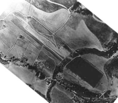
A circa 1941 aerial view of Carmel Valley Airport.
With timing that was quite unfortunate, Byington Ford held the grand opening of Airway Ranch on 12/7/41,
a day of infamy for the United States as well as for Ford's Airpark.
President Roosevelt declared war on Japan the next day.
Building materials became scarce, and civilian flights were prohibited along the West Coast.
Airway Ranch became known as the Double "F" Ranch - "Ford's Folly".
The project was put on hold while Byington Ford joined the Army Air Corps to aid the war effort.
A 7/30/43 aerial view looking north from the 1945 AAF Airfield Directory (courtesy of Scott Murdock)
depicted Carmel Valley Airport as having a single unpaved runway.
Carmel Valley Airport was not yet depicted on the August 1944 San Francisco Sectional Chart.
Carmel Valley was depicted as an auxiliary airfield on the March 1945 San Francisco Sectional Chart (courtesy of Chris Kennedy).
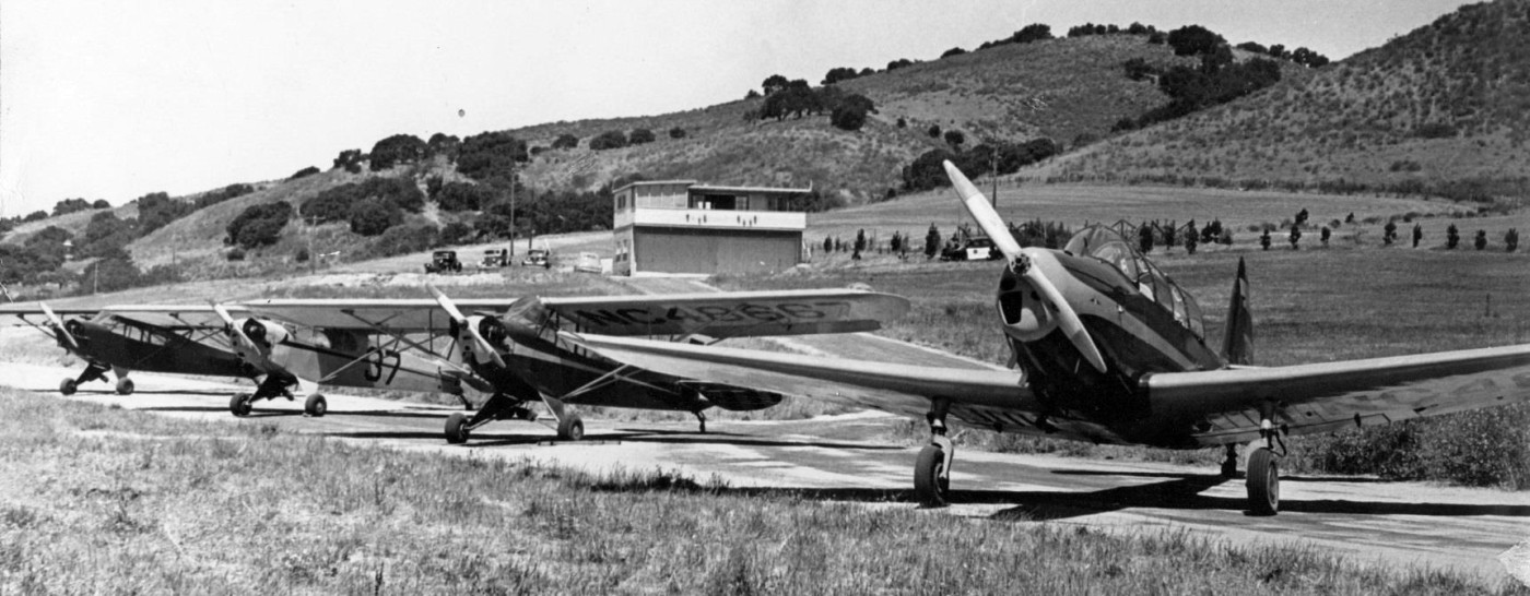
A 1945 photo of 4 single-engine taildraggers at Carmel Valley Airport.
The 1945 AAF Airfield Directory (courtesy of Scott Murdock) described Carmel Valley Airport
as a 31 acre irregularly-shaped property having a single 2,400' east/west gravel runway.
The field was not said to have any hangars, and to be owned & operated by private interests.
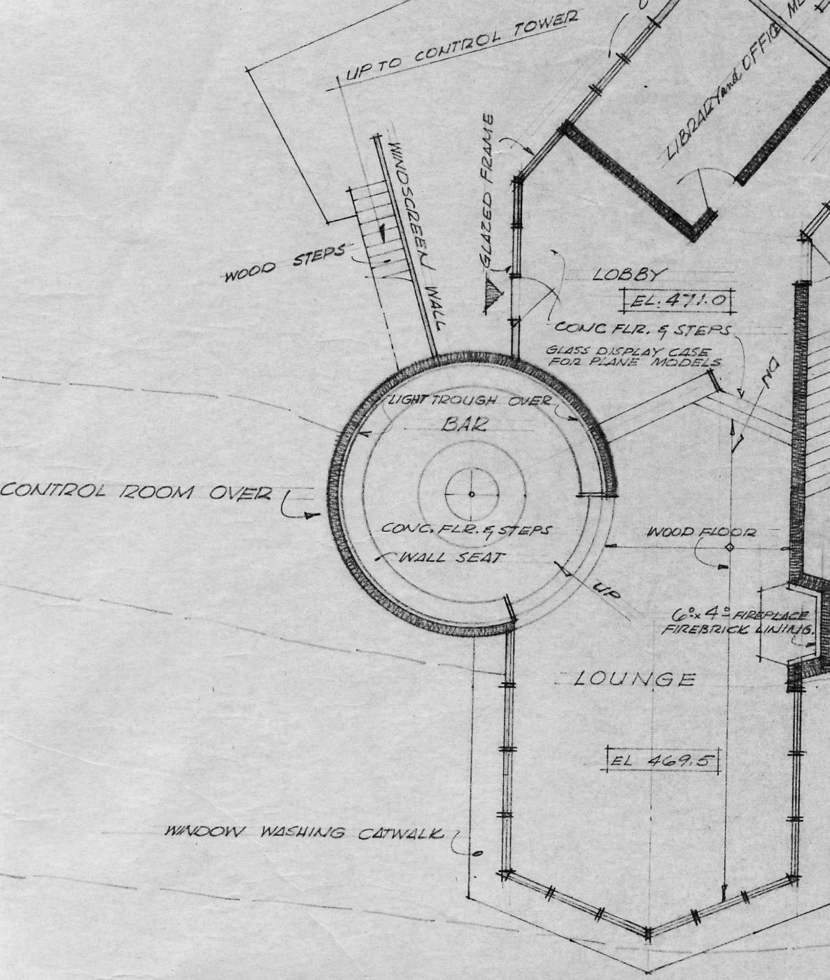
A November 1945 plan for a “Carmel Valley Airport Country Club” drawn by San Francisco architect Gardner Dailey for Tirey Ford
(from a 2014 report by Jeff Ohlson for the Carmel Valley Historical Society).
It was to be located on the north side of the runway & included plans for a lounge, library,
recreation, indoor & outdoor dining, integral airport control tower, and an outside swimming pool.
Ford’s plans for his “Airport Country Club,” however, were never realized.
Following the War it became apparent that there would not be a plane in every garage,
so Ford had to adjust his enterprise, combining sales to plane owners with sales to home seekers, and he enjoyed a brisk trade.
Only 2 true hangar houses were ever built at Carmel Valley Airport: Tirey's (which later burned),
and one other, still standing, on the north side of the runway.
Non-pilots bought up many of the runway Airpark sites,
and to suit their many tastes Byington created ranch-house sites of 1-3 acres
and envisioned hillside homes where residents could look down on incoming planes.
A clubhouse built for the Airpark later became an integral part of the Village's Blue Sky Lodge.
The State of California licensed Carmel Valley Airport in 1949.
An undated aerial view looking north at Carmel Valley Airpark from the 1950 Air Photo Guide (courtesy of Kevin Walsh).
It described Carmel Valley Airpark as having a paved 2,400' northwest/southeast runway, and listed the manager as Robert Sanchez.
A 7/15/53 USGS aerial view depicted Carmel Valley as having an unpaved northwest/southeast runway.
The 1956 USGS topo map depicted the Carmel Valley airfield as a single runway,
labeled simply as “Landing Strip”, with buildings along the south side of the field.
A 5/14/71 USGS aerial view (from the UCSB Library) depicted Carmel Valley as having an unpaved northwest/southeast runway, with a number of light aircraft parked on the north side.
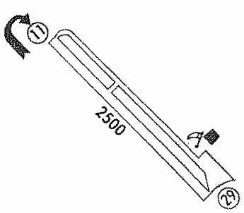
The 1974 Flight Guide (courtesy of Jonathan Westerling)
depicted Carmel Valley as having a 2,500' unpaved Runway 11/29,
with a parallel taxiway on the northeast side, and a ramp & single building on the southeast side of the field.
The runway at Carmel Valley was evidently paved at some point between 1974-77,
as the 1977 Pilot’s Guide to CA Airports (courtesy of Jonathan Westerling)
depicted the field as having a single 2,500' paved Runway 11/29.
Byington Ford retired a few years later, and the airpark was purchased by Peter Delfino.
Delfino liked having an airport available for flyers, although he did not own a plane himself.
He hosted a number of aviation events, including antique fly-ins.
Throughout the 1980s he charged no fees, offered no services, no control tower,
no radio communications or navigation aids, no lights, no gas pump, no mechanic, no telephone, and no office.
Running the airport was largely a grassroots effort.
Delfino shooed horseback riders off the runway, work parties cleaned up the runway & filled potholes,
and donations were collected to keep the grass mowed.
A perimeter trail around the field was enjoyed by countless people for walking, running, horseback riding & dog walking.
Santa Claus deplaned at Carmel Valley each Christmas during the annual Santa's Fly-In.
Carmel Valley also served as important staging area for firefighting & medical helicopters.
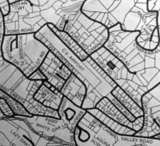
A 1984-85 street map (courtesy of Kevin Walsh) depicted the individual lots bordering the Carmel Valley Airport.
The 1987 Flight Guide (courtesy of Jonathan Westerling) still listed the runway as 2,475’ long,
but the westernmost 650’ had been downgraded to a dirt overrun,
and even the paved portion was described as “Ruf”.
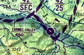
The 1989 San Francisco Sectional (courtesy of Jonathan Westerling)
showed the official length of Carmel Valley’s paved runway had been shortened to 1,800'.
In 1994, Lars de Jounge moved to Carmel Valley, bought a home alongside the airport & leased the airport from the Delfinos.
De Jounge also dreamed of an airpark,
and sought approval from the county planning commission for 10 home sites.
Unfortunately, de Jounge's plan was a little too ambitious for the slow-growth temperament of Monterey County,
and eventually their foot-dragging killed the project.
Meanwhile, developers & so-called environmentalists began eyeing the property,
and their vision did not include airplanes.
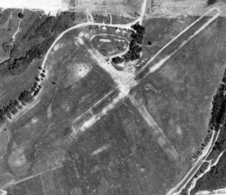
An undated aerial view looking north at Carmel Valley Vintage Airfield from a 1994 publication (courtesy of Kevin Walsh).
A 1994 USGS aerial view looking north depicted a dozen light aircraft parked at Carmel Valley.
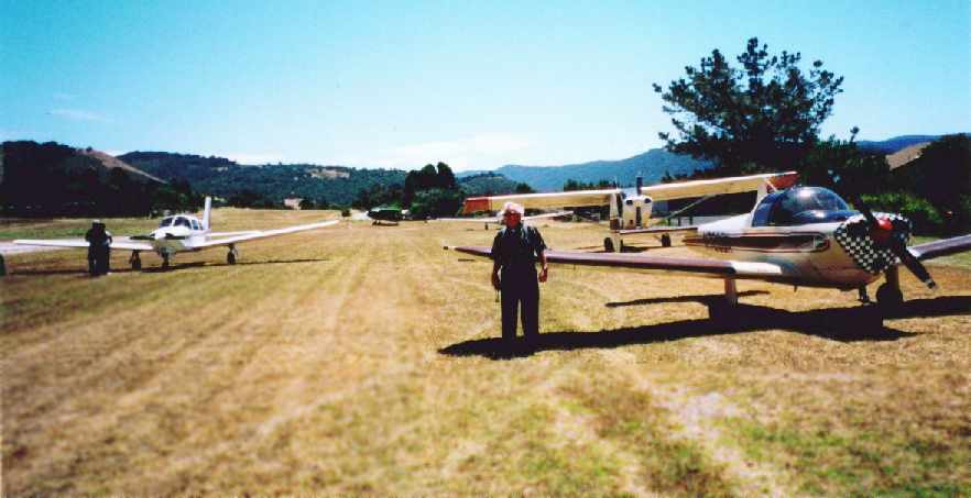
A circa 1995-98 photo of an Ercoupe & several other light aircraft at the Carmel Valley Vintage Airfield (courtesy of Jerry Fargo).
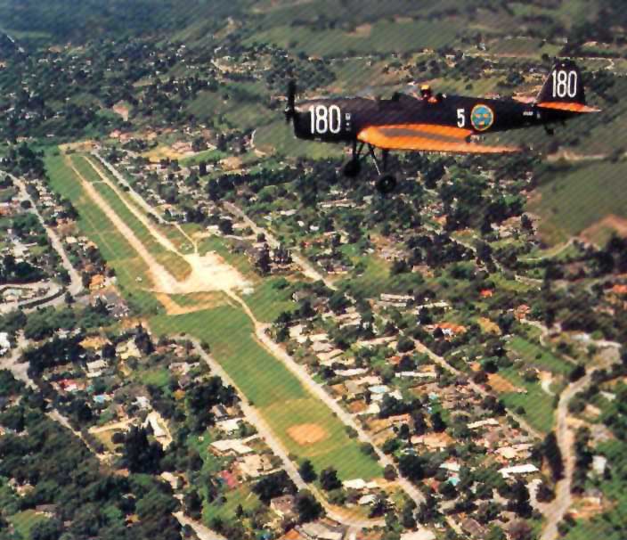
A circa 1997 air-to-air photo of Lars De Jounge's Klemm 35D overflying the Carmel Valley Vintage Airfield,
from a postcard by Lars De Jounge (courtesy of Jerry Fargo, enhanced by Bill Grasha).
![]()
The logo of Carmel Valley Vintage Airfield, from a postcard by Lars De Jounge (courtesy of Jerry Fargo).
Jerry Fargo recalled, “Carmel Valley Airport... was my backyard for 17 years.
In fact I learned to fly out of Carmel Valley and my first airplane crashed just off the east end of the field on the Berta Ranch.
For many years Lou Allaire & I were responsible to keep the airfield mowed & looking good.
We had an old Ford Tractor & later on Lars added a Model B John Deere.
I acted as the 'control tower' for those pilots unfamiliar with the field so if you ever flew in you probably talked to me.
Patching the runway & painting the numbers were also part of the job.
You wouldn't believe what we went thru trying to develop Carmel Valley.
It is a real shame that Lars was not able to complete his dream to build the 11 homes & keep the open space available for the community.
He invested thousand of his own money in cleaning up the area & making it safe for the community & they didn't appreciate it.”
The potholed surface of Runway 29 in 1999.
The Monterey County Board of Supervisors was intent on shutting down the airport,
and a handful of Carmel Valley residents also aligned themselves toward the same goal.
A group of local pilots & concerned citizens formed the Carmel Valley Historic Airpark Society (CVHAS) in 2000,
grabbed some petitions, started talking to the neighbors & set out to fight city hall.
In a fitting ironic twist, the CVHAS used one of city hall's favorite tactics to push their cause -
they turned to environmental protection - a strategy not commonly used to protect an airport.
Unfortunately, local politics & greed conspired against the airport, and Carmel Valley Historic Airpark was closed in 2002.
At the time of Carmel Valley Historic Airpark's closure in 2002, the Airport Facility Directory listed a total of 7 aircraft as being based at Carmel Valley.
Runway 11/29 was listed as 1,820' long, along with the description: "In poor condition, pavement extremely thin & broken up with numerous potholes."
Steve Mann recalled, “The Carmel Valley Airport didn’t have to close,
but the Airpark developer had a deal with Monterey County -
if he could get 10 buyers lined up for his project, they would give him the use permit.
His mistake was that he would not entertain possible buyers that did not own a vintage aircraft.
He never got more than 1 or 2 committed buyers. It’s a real shame, too.”
Jerry Fargo reported in 2005, “When I visited there 2 years ago the field was just sitting there idle.”
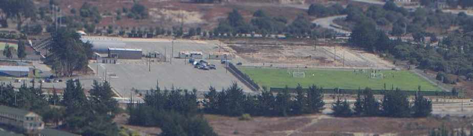
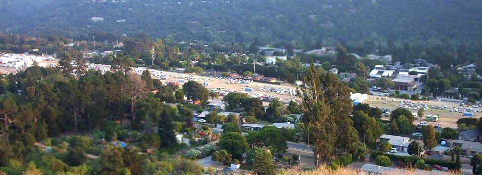
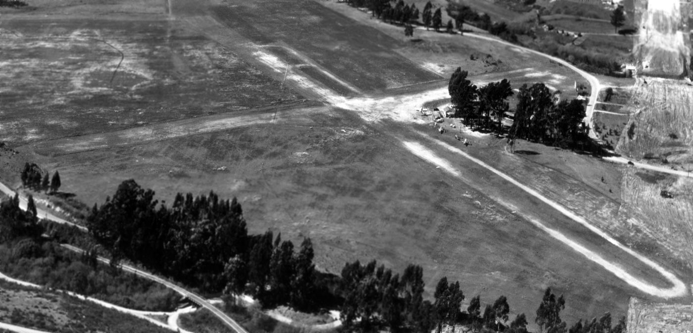
A 2006 panoramic photo by Jonathan Westerling looking west at the former Carmel Valley Airfield.
Jonathan reported, “Note that the hangars & grounds have been well kept-up. The only thing missing is the pilots & their planes.”
A 2006 photo by Jonathan Westerling looking east at the former Carmel Valley Airfield.
Jonathan reported, “One can see the pavement is quite broken up, however the property as a whole remains well maintained, and is used by the residents basically as a park.
Behind me as I snapped this picture, a family had staged an afternoon picnic & were flying a kite.”
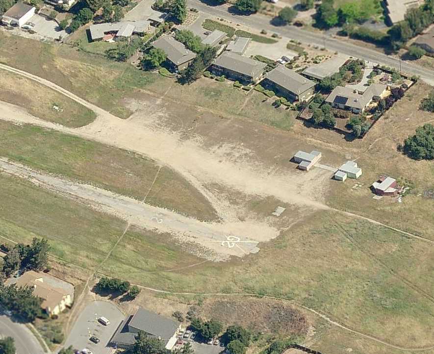
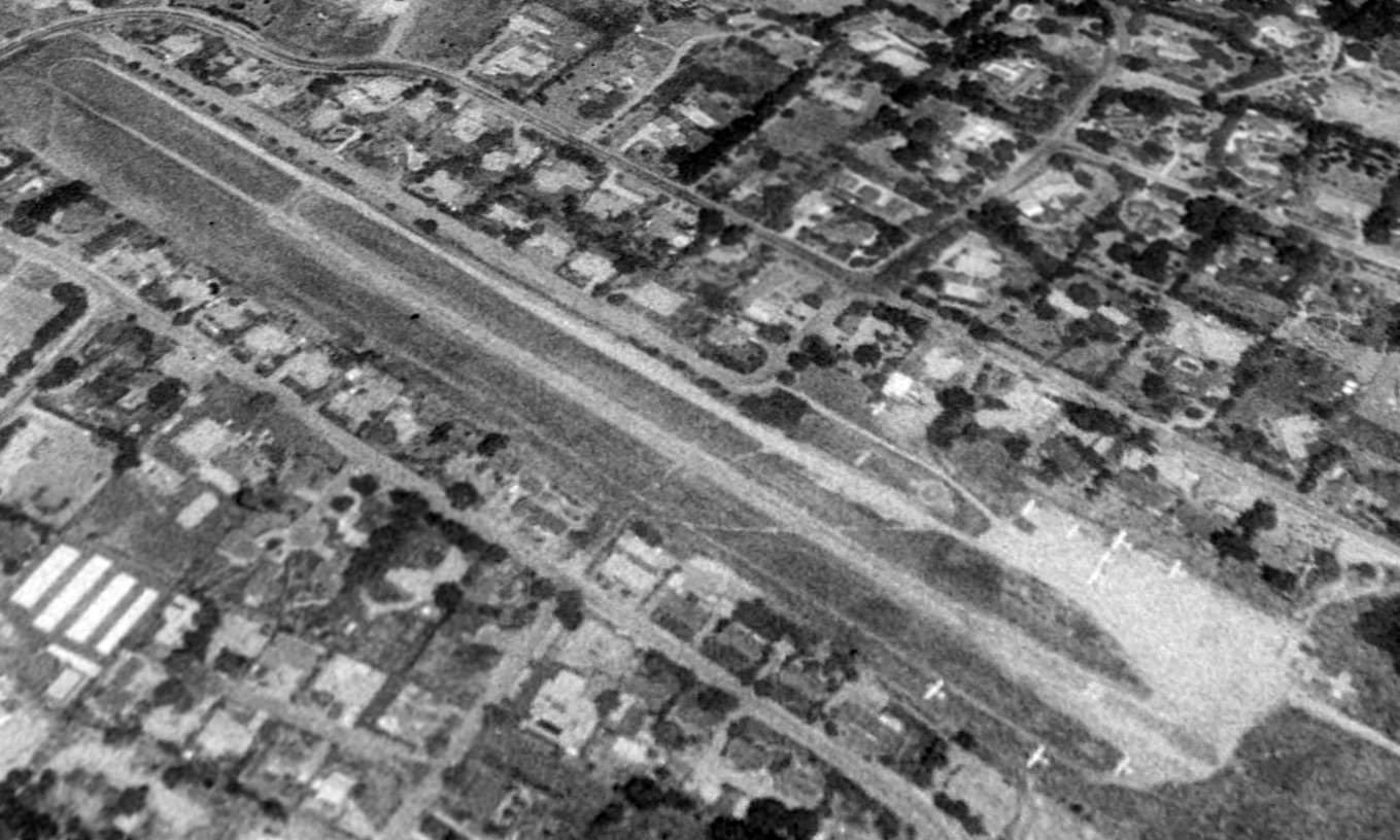
A circa 2006 aerial view looking north at 3 former T-hangars which remain at the site of Carmel Valley.
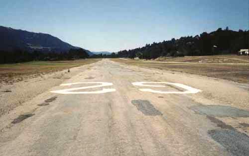
Note the Runway 29 markings, with a “X” painted through the numbers.
A September 2008 photo by John Jacoby of the Carmel Valley runway being used to stage firefighting apparatus
John observed, “These were taken at the Carmel Valley Airstrip on one of the last evenings before they relocated up closer to Cachagua.
[The photo] is taken from up on the hill to give you an idea of how vast an army of personnel they had working the fire.”
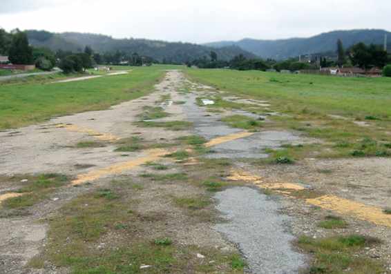
A 2011 photo looking northwest along the former Carmel Valley runway, showing the 3 remaining T-hangars on the right.
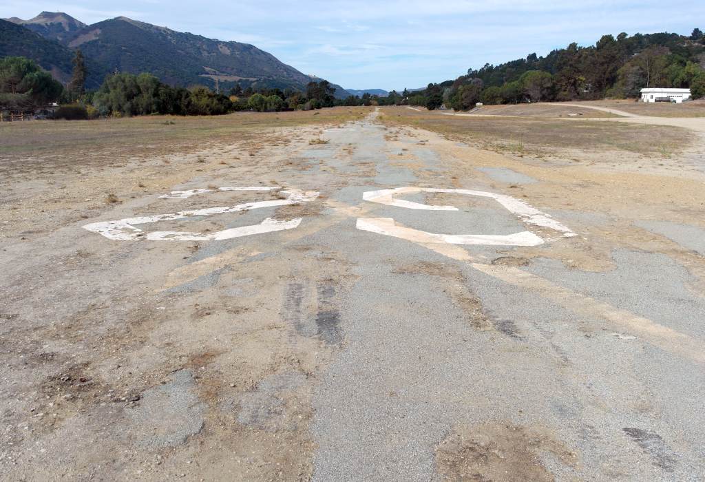
An 11/11/13 photo by Dallam Oliver-Lee looking west along the remains of Carmel Valley's Runway 29, with the runway numbers still visible.
Dallam Oliver-Lee reported in 2013, “I was talking with one of the locals.
He mentioned that airport got recently got bought up by helicopter company & they plan to re-open the airport in the future for helicopters only.”
An 11/11/13 photo by Dallam Oliver-Lee looking northeast at the 3 T-hangars which remain at Carmel Valley.
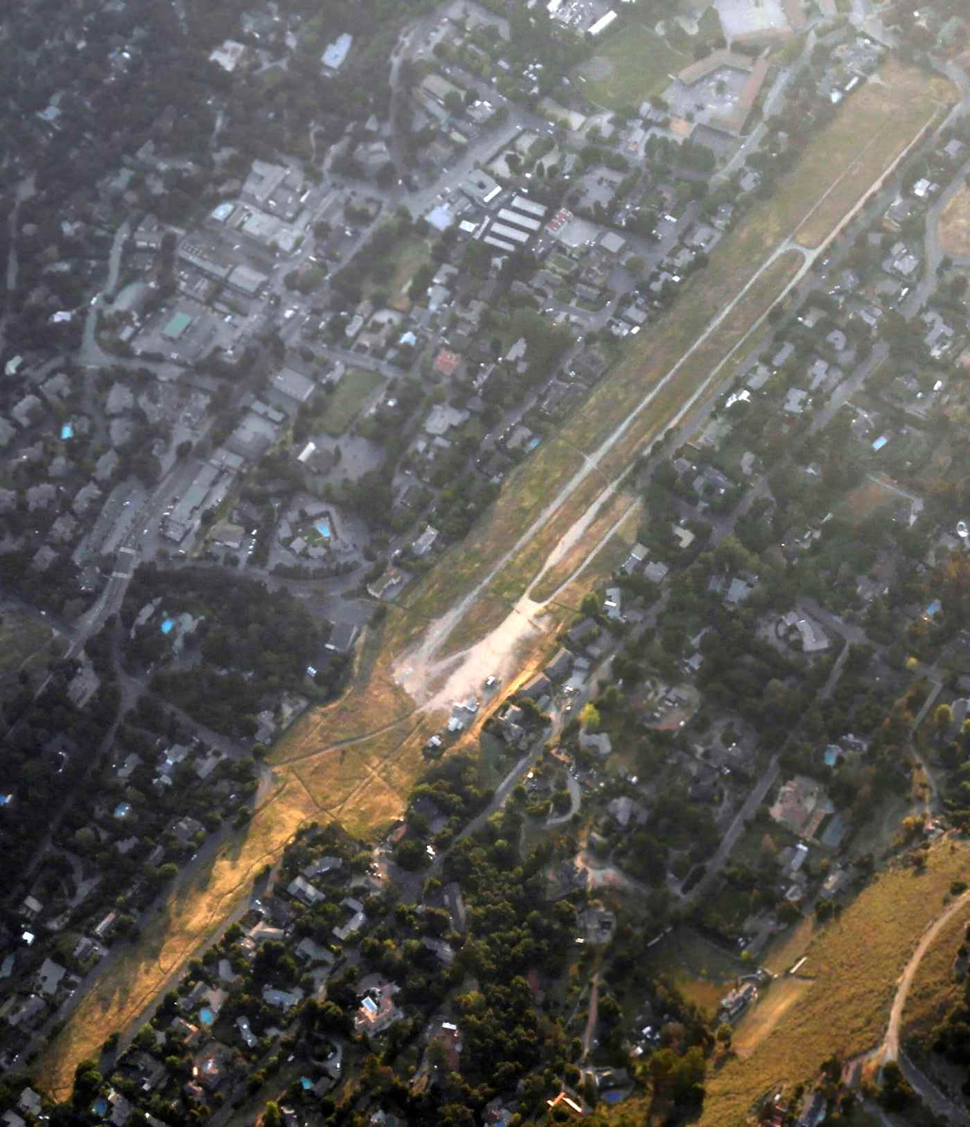
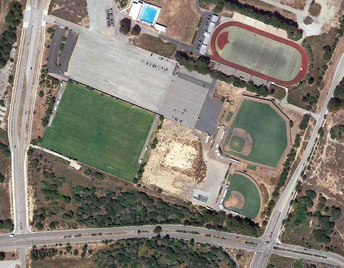
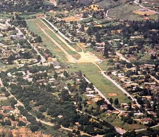
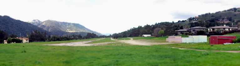
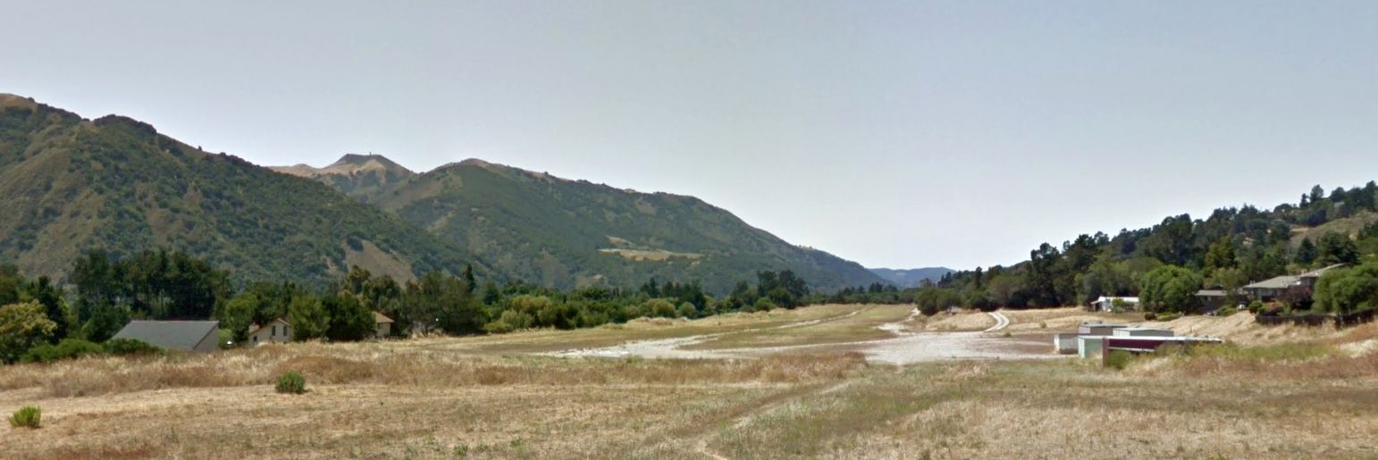
A 4/13/15 aerial view by Dallam Oliver-Lee looking northwest at the remains of Carmel Valley Vintage Airfield.
A 2015 aerial view looking north at the remains of Carmel Valley Vintage Airfield.
What a shame to see this nice little general aviation airfield wasting away.
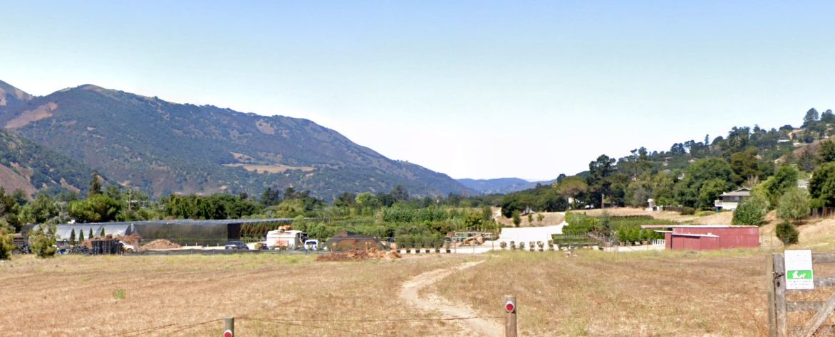
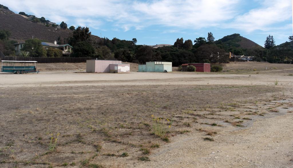
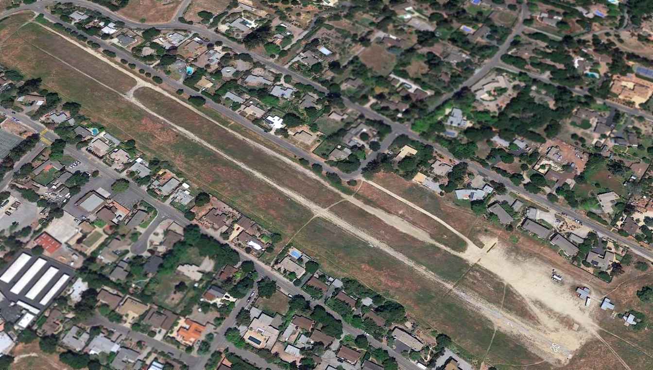
A 2023 photo looking northwest along the former Carmel Valley runway, with a nursery occupying the center of the airfield.
The last remaining trace of the airfield is the sole remaining T-hangar on the right.
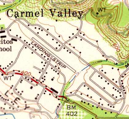
The site of Carmel Valley Vintage Airfield is north of East Carmel Valley Road, south of Ford Road.
Thanks to Joe Pace for pointing out the closure of Carmel Valley.
See also:
http://www.vintageairfield.com/history.htm
http://www.avweb.com/articles/cvva
____________________________________________________
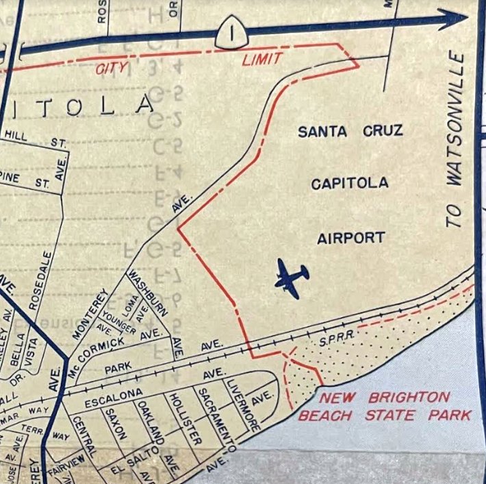
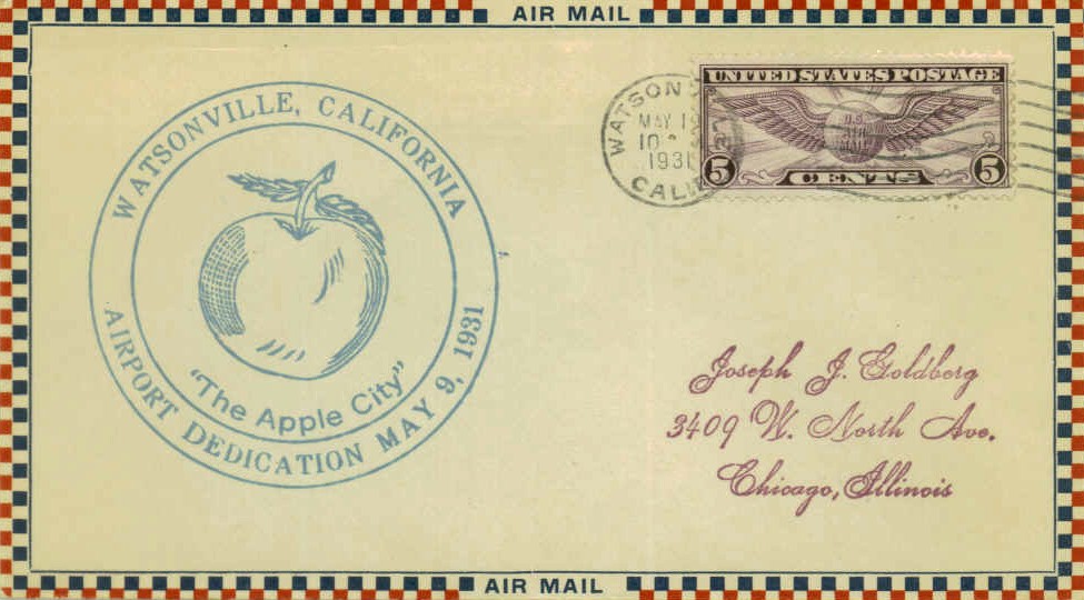
Watsonville Airport (original location), Watsonville, CA
36.867, -121.773 (South of San Jose, CA)
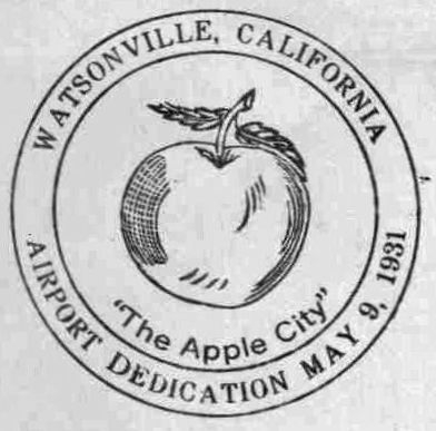
A postmark commemorated the 5/9/31 Dedication of Watsonville Airport.
"Watsonville Airport Incorporated" was formed in 1930 to develop the town's first airport.
Five thousand shares of stock were bought by 400 "largely civic minded citizens"
to purchase land to build an airport.
An 85-acre site southwest of the city, near the junction of Highway 1 & Salinas road in Monterey County,
was chosen for the airport because it was the only land available "at a reasonable price."
In 1931, Governor James "Sunny Jim" Rolph, riding in a Stinson Monoplane piloted by W.W. Bendell,
made a low pass over the runway & cut a ribbon stretched across the field to officially open the airport.
A postmark commemorated the 5/9/31 Dedication of Watsonville Airport.
Harlow Ford was the first president of the board of directors,
and Claude Wilson was the first airport manager & flight instructor.
Other people who were active in establishing the airport were Perry Andrews,
William Bendell, Pete Calaghan, Basil & Kenneth Clark, Floyd McFarlane,
Bill Russell, Charles Tharp, William Waters & Dr. Henry G. Watters.
Some pilots & their planes were Watters (Curtiss Robin), McFarlane, Russell, and Roy Martelli (Eagle Rock),
Clark Brothers (Stinson & later a Ford Tri-Motor), Lou & Harold Foote (Monocoupe), Roy Waugaman (Ryan),
Manager Wilson & Bert Scott (Bird), Russell Kemper (Lincoln Paige), William Neibling (TravelAir),
and Jack Irwin, a later airport manager (Irwin Special).
The earliest depiction of the Watsonville Airport which has been located was on the May 1933 San Francisco Sectional Chart.
It depicted Watsonville as a commercial/municipal airport.
The earliest photo of the Watsonville Airport which has been located
was an undated aerial view looking southwest from the Airfield Directory Company's 1938 Airfield Directory (courtesy of Jonathan Westerling, enhanced by Bill Grasha).
The field was described as having 3 dirt runways, with the longest being the 2,300' northwest/southeast strip,
and a hangar was said to have “Watsonville” on the roof.
A circa 1930s aerial view looking northwest showed 3 single-engine aircraft at Watsonville Airport, along with an array of tents, presumably a military encampment.
A 1938 aerial view of the Watsonville Airport (from the Alexandria Digital Library @ UC Santa Barbara, courtesy of Jonathan Westerling),
showing the original configuration of 3 runways, with several small hangars & 2 single-engine aircraft on the east side.
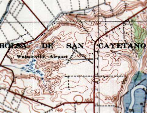
The 1940 USGS topo map depicted the original “Watsonville Airport” as having 3 runways, with 2 buildings on the east side of the field.
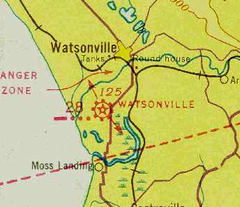
The December 1941 San Francisco Sectional Chart (courtesy of Chris Kennedy) depicted Watsonville as Intermediate Field Site 28.
The Watsonville Airport was leased by the Navy in 1942 to serve as an auxiliary field to support antisubmarine blimp operations from Moffett Field.
The Navy made improvements to the airfield, which eventually consisted of 3 runways (the largest was 2,300') and 3 blimp mooring circles,
all of which were situated within a large irregularly-shaped asphalt area.
Barracks were constructed a total of 116 personnel. The Navy used the airport's existing 60' x 60' hangar.
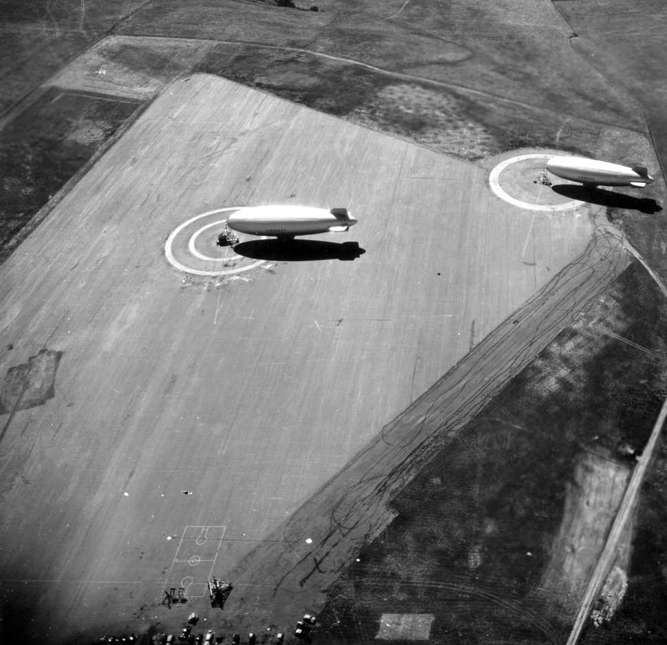
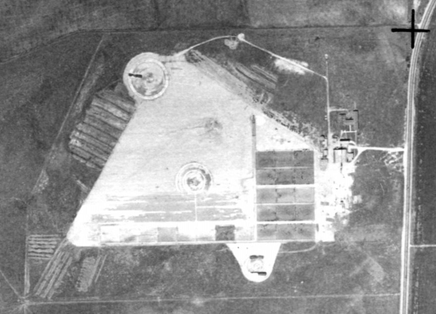
A remarkable U.S. Navy 1940s aerial view looking southwest at 2 blimps moored to portable mooring masts at NAAF Watsonville.
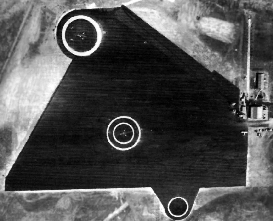
The last photo which has been located of NAAF Watsonville was a 1943 aerial view (National Archives photo, enhanced by Bill Grasha),
showing the runways having been filled-in with an overall asphalt area, within which were 3 blimp mooring circles.
Typical operations at Watsonville during WW2 consisted of a 1 or 2 blimp detachment of K-ships from Moffett's ZP-32.
The blimps would operate 12-hour antisubmarine patrols, convoy escort flights, or assist in air-sea rescues.
Crews were stationed at Watsonville for a month before being rotated with another crew & blimp.
Local men stationed at Watsonville were Don Wilson, George Davis, Vern Dietz & Ron Hill.
"NAAF (LTA) Watsonville" was described by the 1944 US Army/Navy Directory of Airfields (courtesy of Ken Mercer)
as having a 2,300' hard-surface runway, with 2 mooring circles.
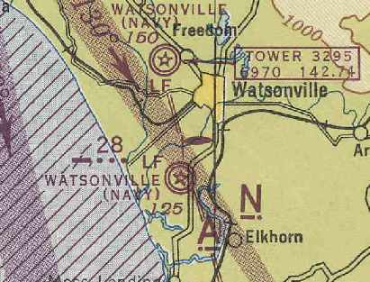
The March 1945 San Francisco Sectional Chart (courtesy of Chris Kennedy)
depicted both the original Watsonville Airport to the southwest of the town, and the new airport to the northwest.
Confusingly, both airfields had the same name on the chart: "Watsonville (Navy)".
The 1945 AAF Airfield Directory (courtesy of Scott Murdock) described Watsonville NAAF
as an 81 acre irregularly-shaped property having a triangular oiled landing mat measuring 1,650' east/west,
with 3 mooring circles with mobile mooring masts.
The field was said to have a single 80' x 70' hangar, to be owned by private interests, and operated by the Navy.
With the end of hostilities, the Navy base at the original Watsonville Airport was closed down in late 1945,
and the 87 acres were returned to the corporation that had built the airport.
A June 1946 Department of Commerce Airman's Guide (according to Chris Kennedy)
redesignated “Watsonville NAAF (LTA)” to “Watsonville Airport #2”, as of 5/27/46.
However, when the larger Navy airfield northwest of town was closed, it became the new Watsonville Airport, and the old airport was closed.
In 1947, the corporation sold the land to Edwin & Flora Peterson, who used it for a cattle feed lot.
A 1948 aerial view of the site of the original Watsonville Airport (from the Alexandria Digital Library @ UC Santa Barbara, courtesy of Jonathan Westerling),
showing the remains of the 3 blimp mooring circles.
The August 1948 San Francisco Sectional chart no longer depicted the original Watsonville Airport.
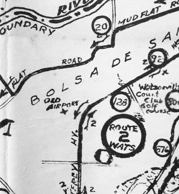
A 1950 road map (courtesy of Kevin Walsh) still depicted Watsonville's “Old Airport”, even though it had been closed for several years by that point.
By the time of the 1954 USGS topo map, the runways of the former Watsonville Airport were no longer depicted at all.
The former airfield buildings were still depicted, though, along with a “beacon”.
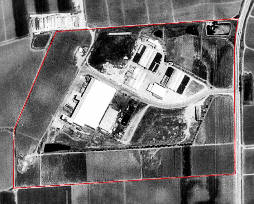
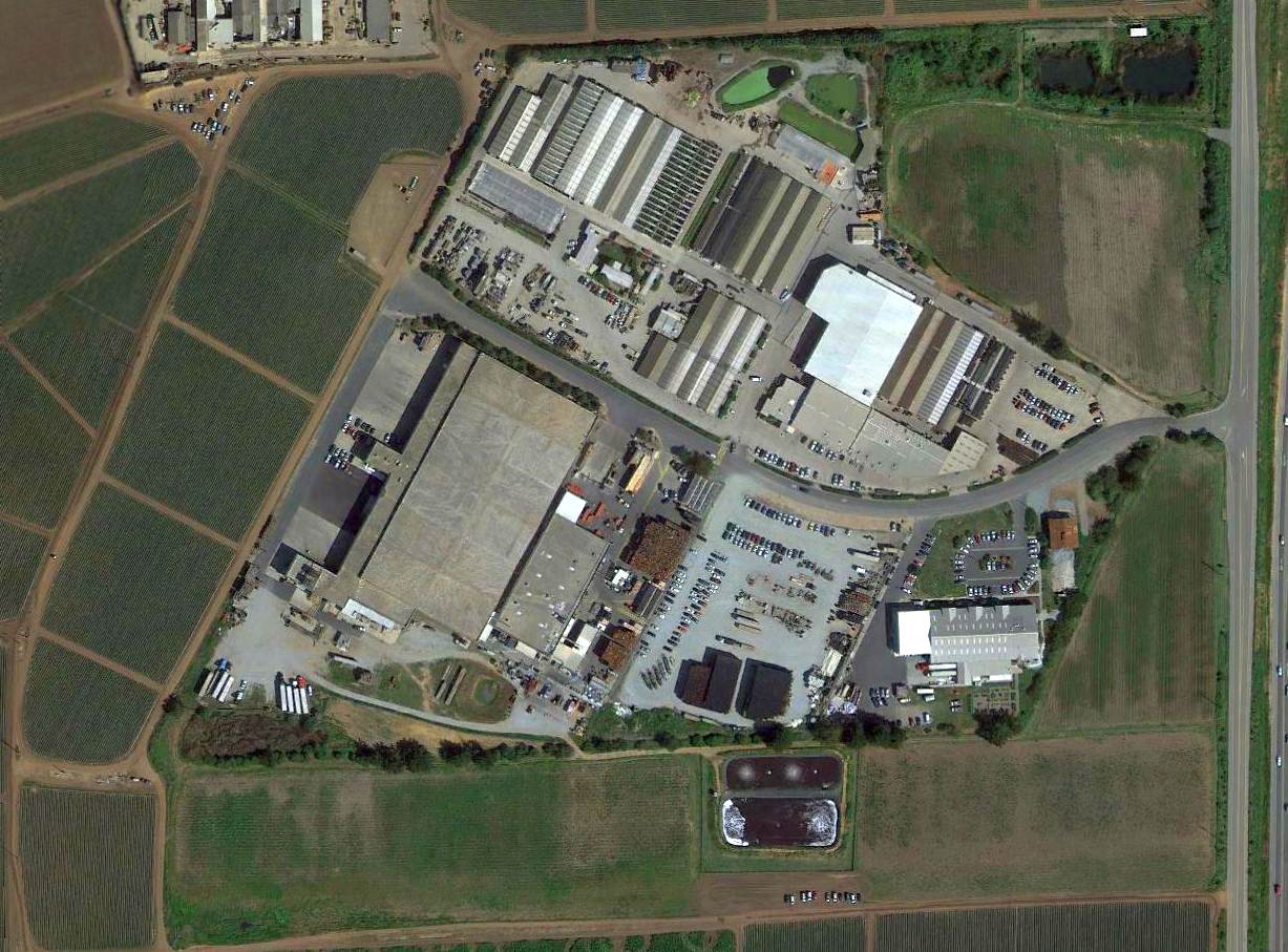
The 1993 USGS aerial photo has been annotated by Ben Mundell of the Army Corps of Engineers
to show the property outline of the former Watsonville Airport.
The precise location of the former airfield was determined by extensive records research
and the acquisition of historic assessor's parcel maps.
Several large agricultural buildings have been erected over the site.
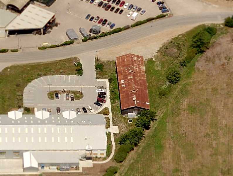
A circa 2006 aerial view looking north at what appears to be a former hangar which remains standing on the east side of the Watsonville Airport site.
This building is noticeably older in appearance than all of the other agricultural buildings on the site,
and it also appears to be the northern of the 2 hangars depicted in the 1943 aerial photo.
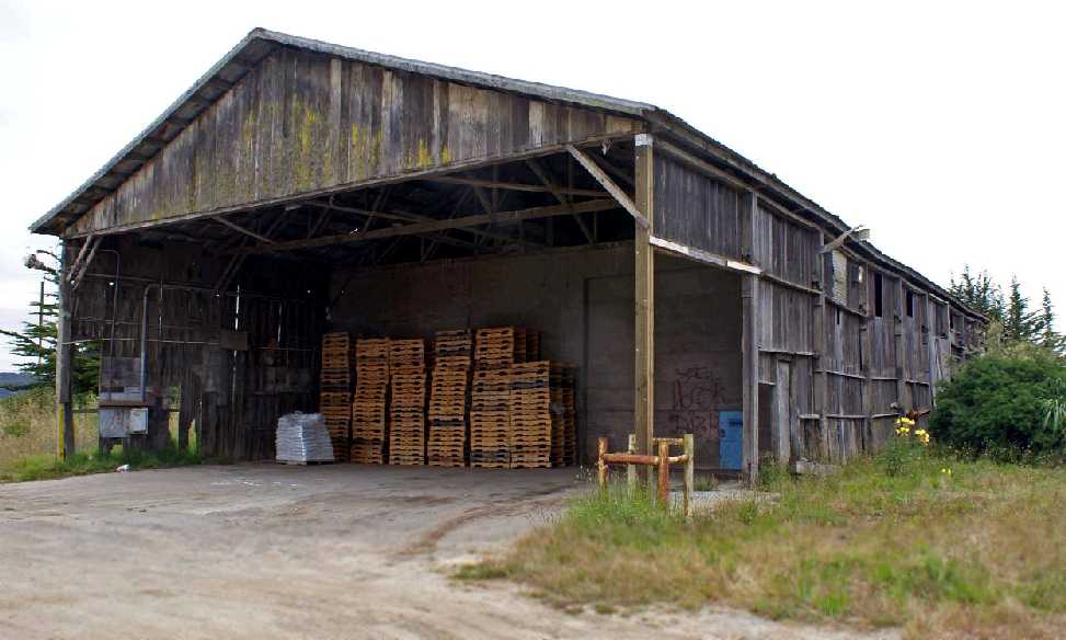
A 7/11/11 photo by John Voss looking southeast at the former hangar at Watsonville.
John reported, “The building looks pretty shaky & I do not know how much longer it will last.
It appears on the east side of the airport running in a north/south direction.”
A 2013 aerial view showed the southern half of the hangar had been removed at some point between 2011-2013.
A 2016 aerial photo of the site of the original Watsonville Airport showed the airfield outline was still recognizable, and the northern half of the hangar still remained.
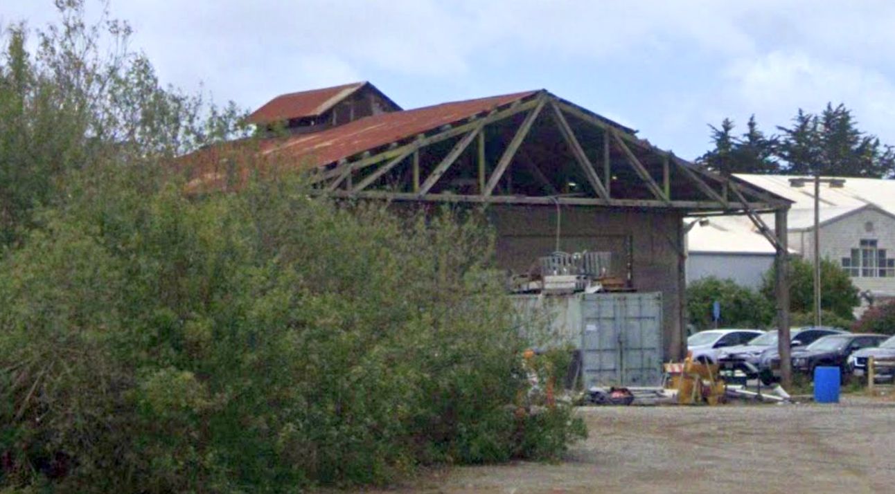
A 2019 photo looking southwest at the former hangar on the west side of the Watsonville Airport site.
See also: http://www.watsonvilleairport.com/History.html
____________________________________________________
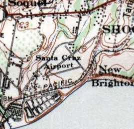
Santa Cruz - Capitola Airport, Santa Cruz, CA
36.982, -121.942 (South of San Francisco, CA)
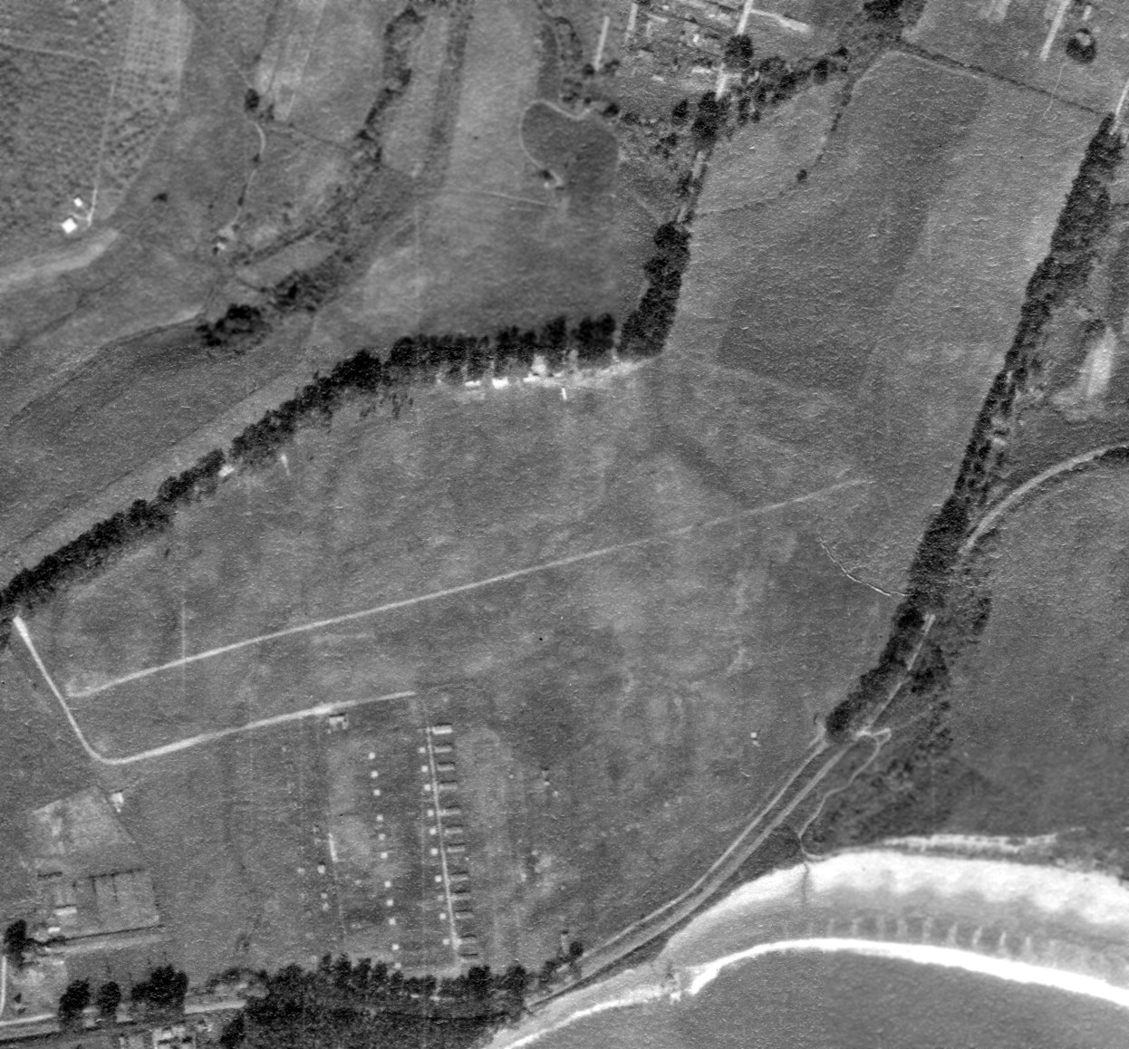
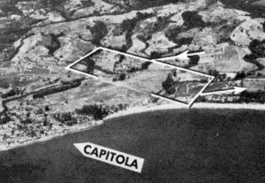
A 1925 aerial view of Capitola Airport (from the UCSB Library, courtesy of Jonathan Westerling).
In the 1920s on the site of the first Capitola schoolhouse & grounds, Santa Cruz County's first airport was established.
According to Carolyn Swift at the Capitola Historical Museum (via Jonathan Westerling),
the Santa Cruz - Capitola Airport was adjacent to Camp McQuaide in the mid-1920s.
Camp McQuaide, part of the 250th Coast Artillery, used the airstrip.
The earliest depiction which has been located of Capitola Airport was a 1925 aerial view (from the UCSB Library, courtesy of Jonathan Westerling).
It depicted the field as having 2 unpaved runways, with what appeared to be a military encampment from Camp McQuaide along the southern side.

A 1926 aerial view looking west at the Capitola Airport (courtesy of Jonathan Westerling).
In 1926 Capitola Airport became the home of Santa Cruz Glider Club, under the direction of Russell & Ester Rice.
A well-known Santa Cruz County flier, Rice & his wife operated the under lease to Santa Cruz Chamber of Commerce.
The 1929 Rand-McNally Air Trails Map of CA (courtesy of Chris Kennedy)
depicted Santa Cruz Airport as an auxiliary airfield, operated by the California Coast Artillery.
The field was said to measure 2,000' x 1,500'.
As described in the Chronology of Airport Development in Santa Cruz County,
the Capitola Airport was in operation in 1931, under lease to Santa Cruz Chamber of Commerce.
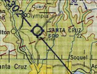
“Santa Cruz” was depicted as a commercial/municipal airport on the 1933 San Francisco Airway Map (courtesy of Chris Kennedy).
A 1934 aerial view looking northeast at the Capitola Airport (courtesy of Jonathan Westerling).
Improvements in 1934 along with the relocation of Camp McQuaide led to the city officially establishing the Santa Cruz-Capitola Airport as its civil airfield.
In 1934 the City of Santa Cruz approved an application to the Emergency Relief Administration for funds for work on Capitola Airport.
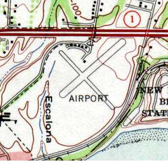
The 1940 USGS topo map depicted the Santa Cruz Airport as having 3 runways,
with a cluster of small buildings north of the runway intersection.
“Santa Cruz” was depicted as a commercial/municipal airport
on the on the December 1941 San Francisco Sectional Chart (courtesy of Chris Kennedy).
An undated aerial view looking north at Santa Cruz Capitola Airport from the Airfield Directory Company's 1941 Airfield Directory
(courtesy of Jonathan Westerling, enhanced by Bill Grasha) depicted the field as an open grass area.
Capitola Airport reportedly continued operations through WW2.
However, it was not listed among active airfields in the 1945 AAF Airfield Directory (courtesy of Scott Murdock).
A 1948 aerial view of Capitola Airport (from the UCSB Library, courtesy of Jonathan Westerling) showed 2 distinct perpendicular unpaved runways not visible in previous photos.
However, Jonathan Westerling pointed out, “You can see the clearing has been done for Route 1 to be built, which cut off the [north]eastern part of the runway.”
Ten light single-engine aircraft were visible parked near several T-hangars on the north side.
A 1948 aerial view looking west depicted Capitola Airport as having 2 unpaved perpendicular runways.
A closeup from the 1948 aerial view depicted 4 light single-engine planes parked near some small buildings on the north side of Capitola Airport.
The August 1948 San Francisco Sectional Chart depicted Santa Cruz Capitola Airport as having a 2,600' unpaved runway.
The last photo which is available showing Capitola Airport was an undated aerial view looking north from the 1950 Air Photo Guide (courtesy of Kevin Walsh).
It described Capitola Airport as having 2 runways: 2,500' Runway 2/20 & 1,600' Runway 12/30, and listed the manager as Russell Rice.
“Santa Cruz - Capitola” Airport was depicted on the 1951 San Francisco Sectional Chart (courtesy of Jonathan Westerling)
as having a 2,400' unpaved runway.
The last photo which has been located showing Capitola Airport still in operation was a 1952 aerial view.
It depicted Capitola Airport as having 2 unpaved perpendicular runways, with 7 light single-engine aircraft parked near some small hangars on the north side.
Jonathan Westerling repored, “Capitola Airport... a 1953 aerial photo clearly shows crops have been planted where the runways used to be
so it was no longer used as an airport at that time.”
A 1953 street map (courtesy of Kevin Walsh) still depicted the Santa Cruz Capitola Airport.
The 1954 USGS topo map (courtesy of Chris Kennedy) depicted the Capitola Airport as having 2 perpendicular runways,
with a cluster of small buildings north of the runway intersection.
Note that the construction of Route 1 had shortened the primary runway, compared to the 1940 USGS topo map.
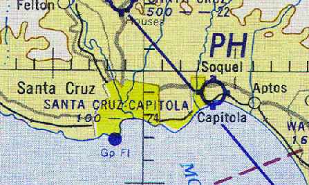
“Santa Cruz - Capitola” Airport was depicted on the September 1954 San Francisco Sectional Chart (courtesy of Chris Kennedy)
as having a 2,400' unpaved runway.
Capitola Airport was abandoned in September 1954,
after owners Russell & Ester Rice transferred their airport operations to the nearby Sky Park.
This was likely due to the increased post war development which happened in the area.
Capitola Airport was no longer depicted on the March 1955 San Francisco Sectional Chart (courtesy of Chris Kennedy).
A 1968 USGS aerial photo & the 1968 USGS topo map depicted a grid of streets having replaced the former Capitola Airport.
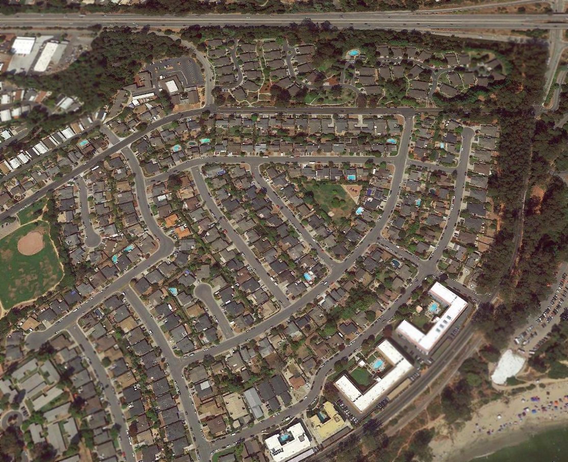
A 2017 aerial view looking north showed the site of Capitola Airport has been densely redeveloped, and not a trace appears to remain of the former airport.
The site of Capitola Airport is located southwest of the intersection of Route 1 & Park Avenue.
____________________________________________________
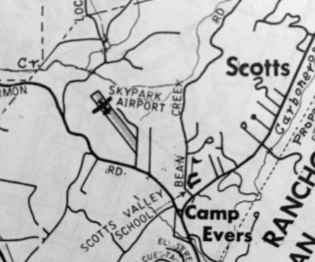
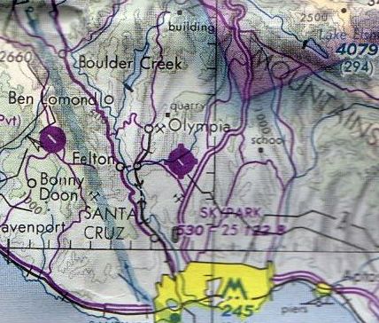
Santa Cruz Skypark (SRU), Scotts Valley, CA
37.052, -122.032 (South of San Francisco, CA)
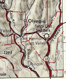
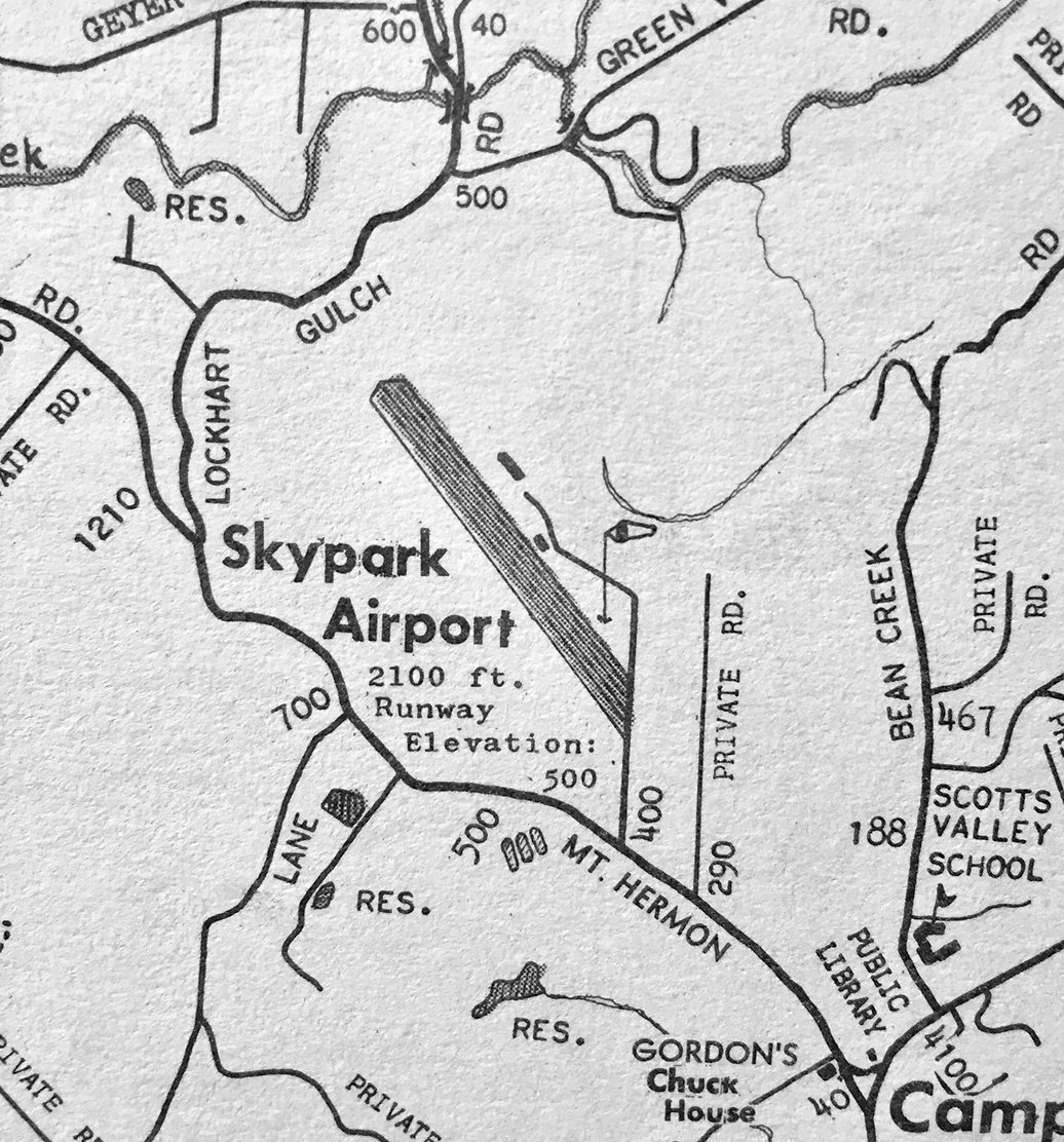
Santa Cruz Sky Park, as depicted on the 1947 USGS topo map.
No airfield was yet depicted at this location on a 1940 aerial photo (according to Jonathan Westerling).
As described in the Chronology of Airport Development in Santa Cruz County,
Sky Park Airport began operation in 1947 as a privately-owned field built by Jack & Lola Graham on their property.
One of its primary purposes was to provide a facility for training of pilots under terms of the G.I. Bill.
The earliest depiction which has been located of Santa Cruz Sky Park was on the 1947 USGS topo map.
According to K.O. Eckland, Santa Cruz Skypark was depicted on a 1948 Sectional Chart as having a 2,100' runway.
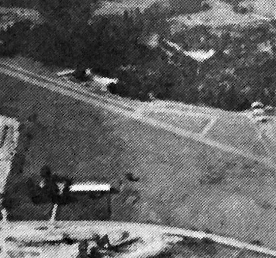
The earliest photo which has been located of Santa Cruz Skypark was a 1948 aerial view looking northwest.
It depicted Santa Cruz Skypark as having a single asphalt northwest/southeast runway & parallel taxiway, and a paved ramp on the east side.
A 1948 aerial view (from the UCSB Library, courtesy of Jonathan Westerling) depicted Santa Cruz Skypark
as having a single asphalt northwest/southeast runway & parallel taxiway, and a paved ramp on the east side.
The earliest aeronautical chart depiction which has been located of Santa Cruz Skypark was on the August 1948 San Francisco Sectional Chart.
It depicted Santa Cruz Sky Park as having a 2,100' paved runway.
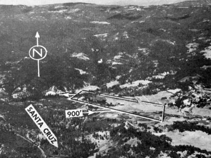
An undated aerial view looking north from the 1950 Air Photo Guide (courtesy of Kevin Walsh),
which described Santa Cruz Skypark as having a paved 2,100' Runway 9/27, and listed the manager as George Brady.
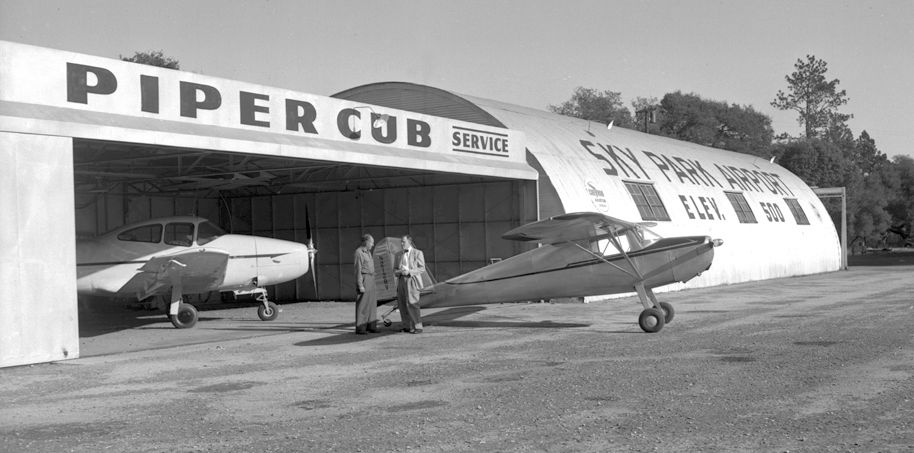
A 1953 photo showing a Navion & Cessna 140 in front of a hangar & Quonset hut painted with “Sky Park Airport”.
In 1953, the State Director of Aeronautics submitted a report which recommended Sky Park
as the most feasible site for development of a municipal airport for the City of Santa Cruz.
In 1954 the nearby Capitola Airport was abandoned,
and owners Russell & Ester Rice transferred their airport operations to Sky Park,
which they had been leasing from the Grahams.
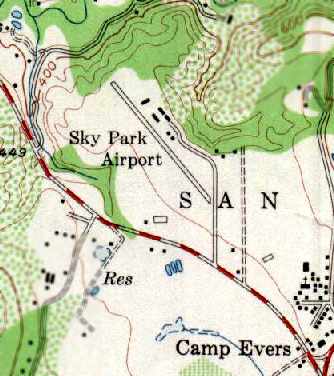
The 1955 USGS topo map depicted Sky Park Airport as having a single northwest/southeast runway,
with 6 buildings on the northeast side of the field.
The March 1955 San Francisco Sectional Chart (courtesy of Chris Kennedy)
depicted Santa Cruz Airport as having a 2,200' unpaved runway.
In 1957 the Santa Cruz Chamber of Commerce passed a resolution
encouraging the City to sell lands originally acquired for the planned Swanton Airport
and to use the money for acquisition & operation of Sky Park.
An accompanying study cited the advantages of Sky Park.
A heliport could be developed there to provide short-haul public transportation
with connections to Watsonville Airport "which can be expanded to meet the needs of the jet age".
“Skypark Airport”, as depicted on a circa 1960 county map (courtesy of Kevin Walsh).
An undated aerial view of Skypark from a circa 1960 county map (courtesy of Kevin Walsh).
It described Skypark Airport as having a 2,100' runway, and listed the manager as Russell Rice.
In 1960 the City of Santa Cruz was again urged to acquire Sky Park, this time in a citizens' group report called "Santa Cruz of Tomorrow".
Realignment of the Sky Park runway to add 500' was proposed.
In 1961 H.K. Friedland & Associates completed a Preliminary Airport Site Selection Study
under contract to the City of Santa Cruz.
Sky Park was deemed inadequate because many FAA criteria could not be met & federal aid therefore would not be obtainable.
Later in 1961 the Santa Cruz Airport Commission noted that Sky Park was for sale, and that it was the best facility for airport purposes.
The City - in cooperation with the County, if possible - was urged to acquire the Airport.
The Santa Cruz City Council requested the California Aeronautics Commission to grant waivers of certain Sky Park deficiencies,
and, in the event the City and/or the County of Santa Cruz purchase the airport, to reissue an airport permit.
In 1962 the Santa Cruz City Council approved a resolution to acquire Sky Park,
and the City Council approved an agreement to purchase the 45.8 acre Sky Park property from owner Jack Graham for $197,000.
The existing lease between Graham & Russell & Esther Rice for operation of the airport was to be honored by the City.
The 1962 AOPA Airport Directory described Santa Cruz Skypark
as having a 2,100' oiled runway, and the operator listed as Russell Rice.
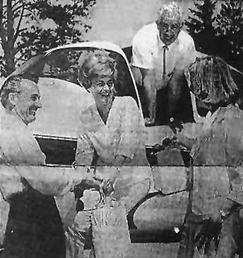
A 1963 photo by Ester Rice (courtesy of Mike Townsend, enhanced by Bill Grasha)
of Ray Stewart returning to Scotts Valley Sky Park Airport after a flight to Cuyama Valley in a Navion.
The Sky Park property was annexed to the City of Santa Cruz in 1964.
In 1965, James Dahm took over the Rices' lease for operation of Sky Park.
In 1966 the Master Plan of the Santa Cruz Municipal Airport (Sky Park) was approved by Santa Cruz City Council.
In the same year the City of Santa Cruz requested $11,700 in federal aid for construction of a realigned runway & parallel taxiway at Sky Park.
Total project cost was estimated at $23,400.
The Federal Aviation Administration turned down the Sky Park grant application
because the proposed construction would not meet federal standards.
A circa 1960s map by R.A. Orr (courtesy of Kevin Walsh) depicted Skypark Airport as having a single 2,100' northwest/southeast runway.
By 1966, the runway had been paved with asphalt,
as indicated in the Aerodromes table on the reverse side of the 1966 San Francisco Sectional chart (courtesy of John Voss).
The 1968 USGS topo map depicted the original runway at Sky Park, along with the realigned runway which replaced it.
In 1968 a 25 year lease agreement between City of Santa Cruz & James Dahm for operation of Sky Park was signed.
Jim Hayes recalled, “I got my Airplane Single Engine Land [Pilot's License] at Skypark in May, 1968.
I took my check ride in May while the new runway was in process -
on a 900' section of the original runway, which was 1,900'.
Frank Shelley, ex-Navy & oil field chopper pilot was my instructor and he was still there in the late 1970s.
Part of the problem with Skypark was the terrain.
While I was getting my license, we had 2 crashes - I remember pulling people out of a 182.
I used to fly solo over to Watsonville & bring planes back with a little more fuel!
The unique part was takeoff toward a mountain - left turn to stay in the pattern -
right to leave pattern, choosing which of 2 valleys you flew down. Memories!”
The 5/1/69 San Francisco Sectional Chart (courtesy of Bob Briggs)
depicted Skypark as having a single paved 2,600' northwest/southeast runway.

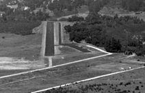
A 1971 photo by Jim Hayes (enhanced by Bill Grasha) on final approach to Santa Cruz's Runway 13,
showing the hangars on the northeast side of the field, and the sharp cliff just off the runway end.
Also note the remains of the former runway, to the right of Runway 13.
Jim recalled, “The end of the runway was a surprise for some pilots taking off on [Runway] 31
as the wind could whip up pretty good in the valley below & create some nasty updrafts.
I believe it was a Mooney that got caught in an updraft, overreacted & ran into the trees below.”
Stuart Till recalled, "Until it was closed, it was managed/operated by Jim Dahm.
Jim ran a flying school there where I obtained my instrument rating under the GI bill in about 1972,
using an old WW2 military surplus Link Trainer for simulator time.
The runway had lights,
but Jim would not turn them on unless he knew you & knew you were competent to land there at night.
He would turn them on after a call on Unicom.
Jim lived on the field in a mobile home."
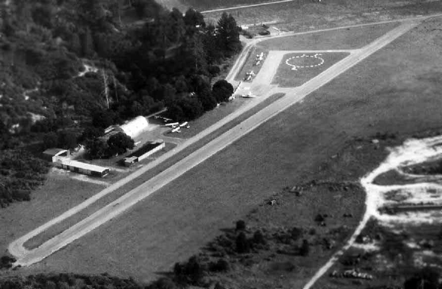
A circa 1970s aerial photo looking southeast at Santa Cruz Skypark (courtesy of Dan Dawson, enhanced by Bill Grasha),
showing a paved runway, several hangars, and about a dozen light aircraft.
In 1975 the County performed a "Preliminary Initial Study" of Sky Park
to provide background for development of airport policies to be included in the County Regional Transportation Plan.
The policy as ultimately adopted by the County Regional Transportation Commission
recommended that Sky Park remain a recreational airport operating at a level no greater that it then was.
According to Jim Hayes, “Jim Dahm developed cancer in the late 1970s & died, so I'm guessing that was one reason it fell apart.”
The last aeronautical chart depiction which has been located of Skypark
was on the April 1980 San Francisco Sectional Chart (courtesy of Mitchell Hymowitz).
It depicted Skypark as having a single paved 2,500' northwest/southeast runway.
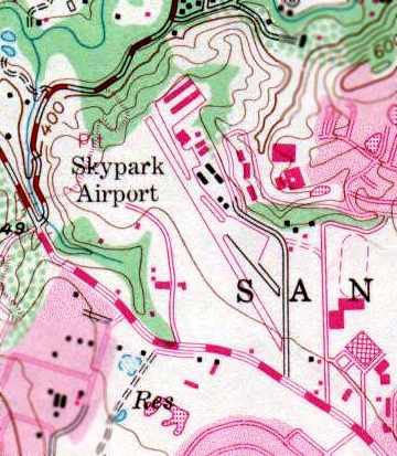
The 1980 USGS topo map depicted “Skypark Airport” as having a a single runway,
with a number of hangars along the east side of the field.
Santa Cruz Skypark was listed in the 1982 AOPA Airport Directory (courtesy of Ed Drury),
which described the field as consisting of a single 2,520' asphalt Runway 13/31, and listed the operator as Sky Park Airport.
Don Rodrigues recalled, "We used to land regularly at Santa Cruz Skypark which was a challenging little strip.
If I'm not mistaken, the combination of development & some unfortunate crashes doomed the airport."
Steve Mann recalled, “The crash at the Scot’s Valley Airport that doomed it was by none other than Steve Wozniak, of Apple fame.”
This was on 2/7/81, when Wozniak crashed his Beechcraft Bonanza while taking off from Skypark.
His injuries forced his temporary departure from Apple Computer.
Santa Cruz Skypark closed in January 1983.
Santa Cruz Skypark was depicted as an abandoned airfield on the 1990 San Francisco Sectional Chart (courtesy of Dann Shively).
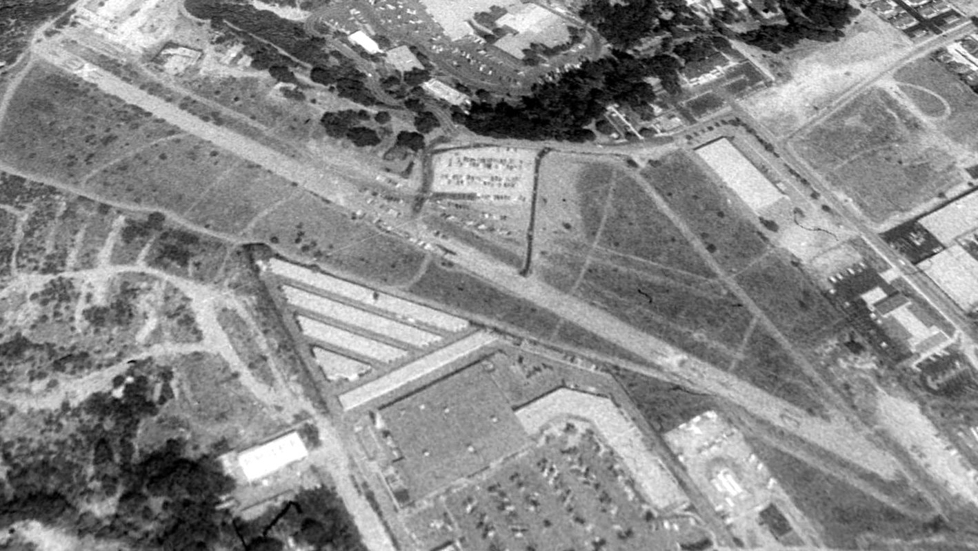
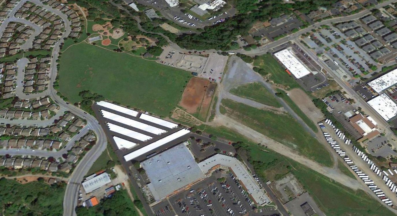
A 1991 USGS aerial view looking northeast at the site of Santa Cruz Skypark showed the entire length of the runway still remained intact.
Furthermore, a small segment of the original runway (used from 1947-66) was still visible as well,
just northeast of the south end of the primary runway.
Santa Cruz Skypark was still depicted as an abandoned airfield on 2003 aeronautical charts.
Matt Humphrey observed in 2003, "Having lived here all my life, I have seen it go from a nearly intact airport to just another large scale housing development.
There is however about a 100 yard section of the runway left, and remnants of taxiways & a few tie-downs.
Sadly even this will be gone within a few years, as there are plans to build another shopping center right over it."
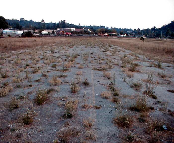
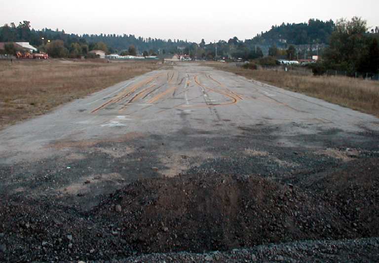
A 2003 photo by Jonathan Westerling, looking east at the remains of the original (1950s) paved runway at SkyPark.
Jonathan reported, “This runway was 2,100' & was abandoned in the mid 1960s when the runway was realigned to add about 500'.
The yellow centerline is still visible, but the white numbers at the end were impossible to make out."
A 2003 photo by Jonathan Westerling, looking south at the remaining few hundred feet of pavement of the primary runway at SkyPark.
Jonathan reported, “The yellow lines are from the city's road painting crew who used the strip for practice."
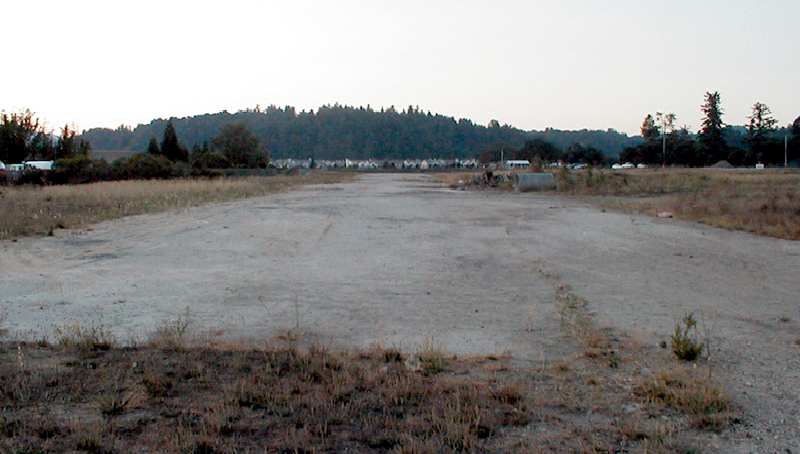
A 2003 photo by Jonathan Westerling looking north from the end of the remaining pavement at SkyPark.
Jonathan reported, “The pavement was in fair condition & broken up in spots.
A pile of debris, perhaps remnants of the airport, are visible off to the right.
Notice the looming hill which made approaches to the little field quite challenging."
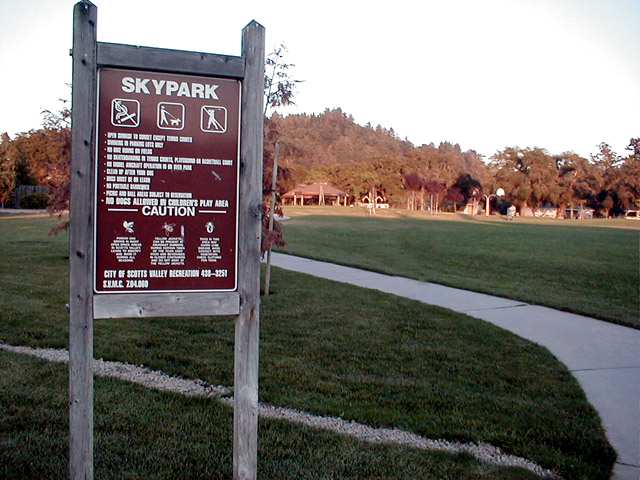
A 2003 photo by Jonathan Westerling.
"East of the runway (where the ramp used to be) there is now a park with a playground, soccer field and dog area.
Unfortunately, I couldn't find any plaques explaining the history of the airport that gave the park its name."
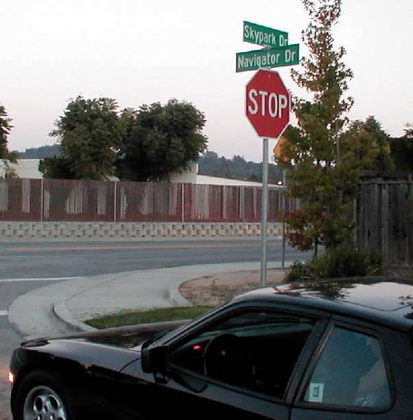
A 2003 photo by Jonathan Westerling, who reported, "There is now a housing development at the north end of the airfield.
Some of the streets have names which hearken back to the history of the airfield…
SkyPark Drive, Navigator Drive, Aviator Court, and Airstream Court."
Jonathan's sporty Porsche 944 is in the foreground.
A February 2005 aerial photo by Jonathan Westerling, looking northwest along the remains of the runways at Santa Cruz Skypark.
Jim Hayes remarked that the cliff which used to be just off the north end of the runway
is “smoothed out & covered with houses today!”
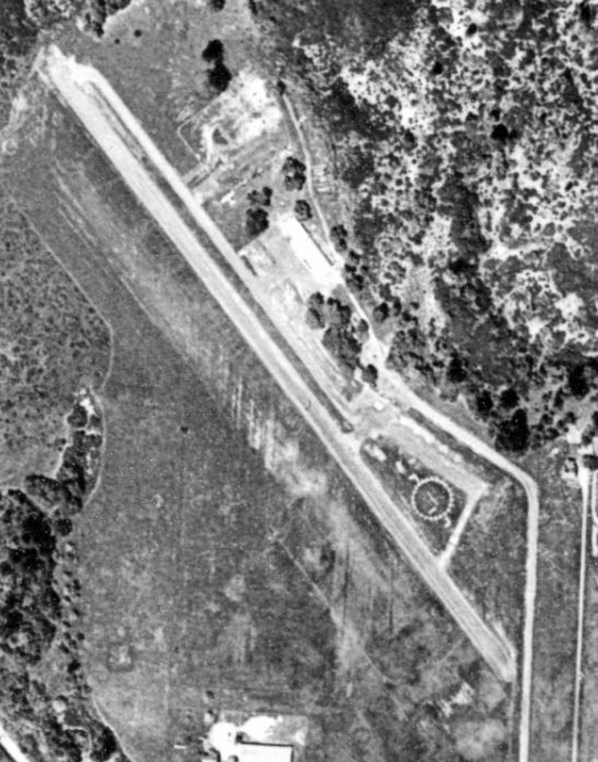
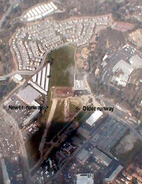
A circa 2006 aerial view looking north at the southern portion of the site of the Santa Cruz Skypark,
showing the remains of the southeast ends of both runways.
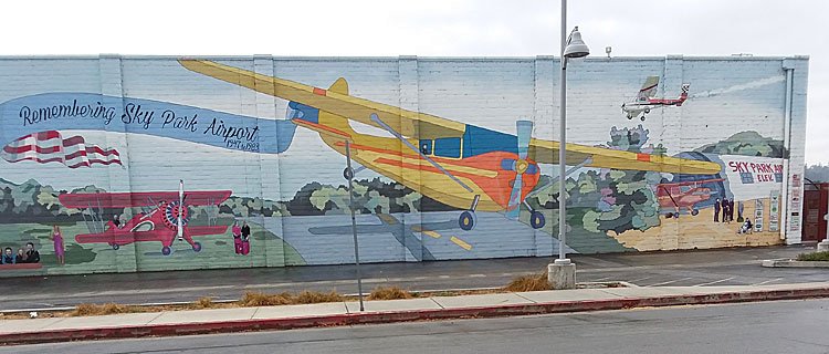
A circa 2013-2017 photo (courtesy of Jonathan Westerling) of the mural commemorating Sky Park Airport painted in 2013 by the Regional Artisans Association on the side of the new Santa Cruz Library.
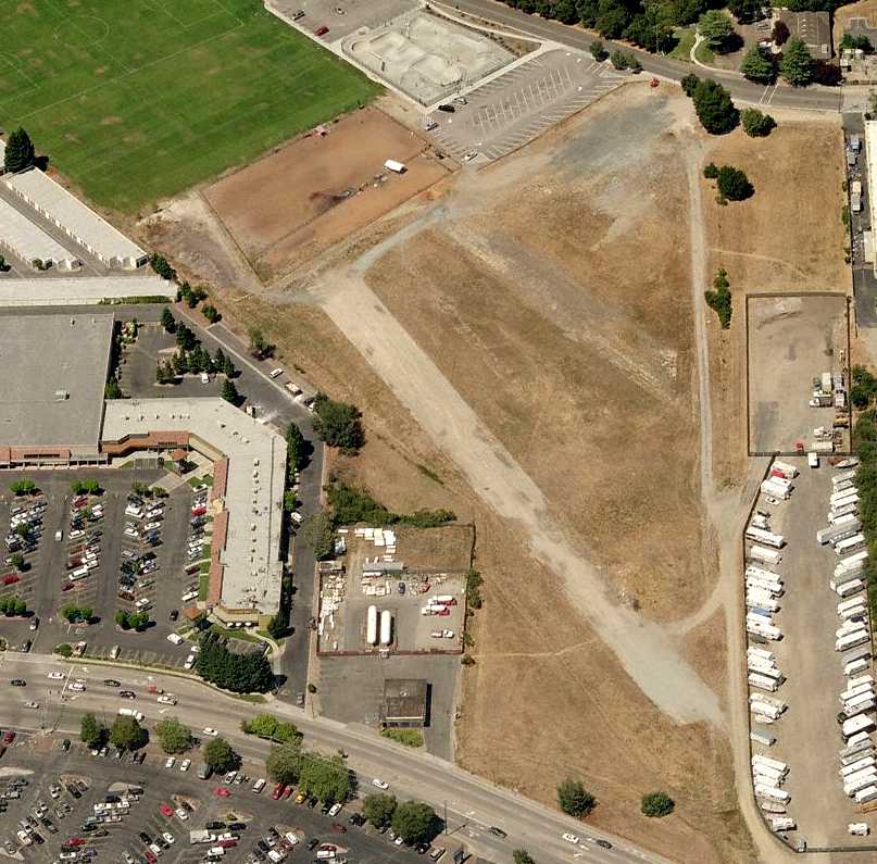
A 2016 aerial view looking northeast at the site of Santa Cruz Skypark showed the remains of the southern portion of 2 runways remained recognizable.
Thanks to Timothy Aanerud for pointing out this airfield.
____________________________________________________
Since this site was first put on the web in 1999, its popularity has grown tremendously.
If the total quantity of material on this site is to continue to grow,
it will require ever-increasing funding to pay its expenses.
Therefore, I request financial contributions from site visitors,
to help defray the increasing costs of the site
and ensure that it continues to be available & to grow.
What would you pay for a good aviation magazine, or a good aviation book?
Please consider a donation of an equivalent amount, at the least.
This site is not supported by commercial advertising –
it is purely supported by donations.
If you enjoy the site, and would like to make a financial contribution,
you
may use a credit card via
![]() :
:
Please consider checking the box to make a monthly donatation.
For a mailing address to send a check, please contact me at: paulandterryfreeman@gmail.com
If you enjoy this web site, please support it with a financial contribution.
This site covers airfields in all 50 states.