
Abandoned & Little-Known Airfields:
California: Inyo County
© 2002, © 2023 by Paul Freeman. Revised 8/29/23.
This site covers airfields in all 50 states: Click here for the site's main menu.
For the 6th year, the CA pages of this website are sponsored by the California Pilots Association:
____________________________________________________
Please consider a financial contribution to support the continued growth & operation of this site.
Adamson Airport / Olancha Airport (revised 10/2/20) - Charleston View Airfield (added 8/29/23) - Death Valley Airport (original location) / Furnace Creek Airport (revised 10/8/20)
Grant Airport / Grants Airport / Grants Airpark (revised 1/25/17) - Inyo County Airport / Manzanar Airport (revised 8/29/23)
Panamint Springs Airport (revised 8/29/23) - Panamint Springs Auxiliary Airfield (added 12/17/20)
____________________________________________________
35.97, -115.854 (West of Las Vegas, NV)
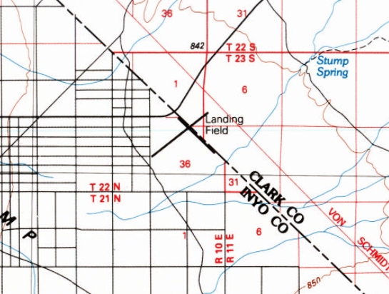
Charleston View Airfield, as depicted on the 1985 USGS topo map.
Photo of the airfield while in use has not been located.
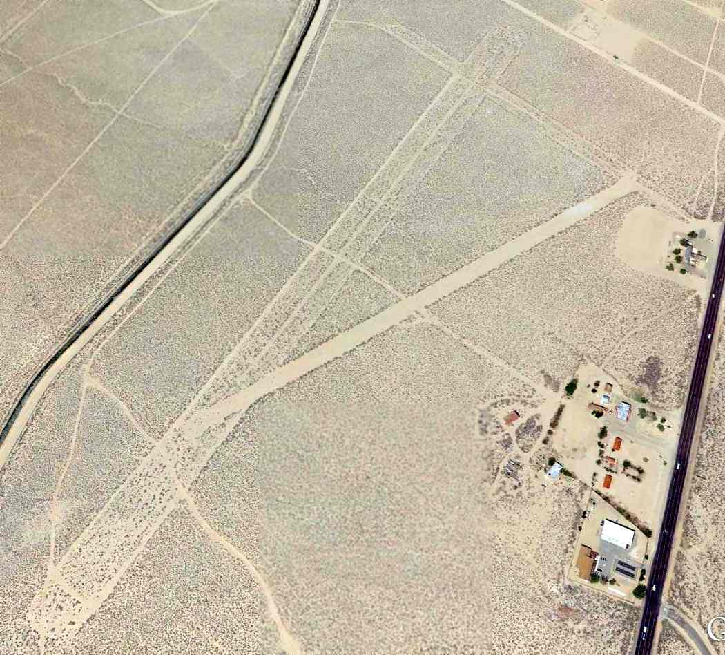
This remote desert airfield straddles the CA/NV border, with the northwest/southeast runway lying parallel within the CA border,
and the northeast/southwest runway extending perpendicularly into NV.
The Charleston View Airfield was not depicted on the 1971/1977/2000 Las Vegas Sectional Charts or the 1976 USGS topo map.
Lenny David reported, “The Charleston View Airstrip was built in the 1970s as a landing strip for firefighting aircraft.
It is located 2 miles west of the Hidden Hills Ranch airstrip. There were north/south & east/west strips built.”
The earliest depiction which has been located of the Charleston View Airfield was on a 1978 aerial photo.
It depicted 2 perpendicular unpaved runways, with no other improvements, or any indication of recent aviation use.
The only topo map depiction which has been located of the Charleston View Airfield was on the 1985 USGS topo map.
It depicted 2 perpendicular runways, labeled generically as “Landing Field”.
Lenny David reported, “The last time I know for certain that the airstrip was used to smuggle drugs was October 1986.
A Cessna 206 landed from Mexico with 900 pounds of marijuana. U.S. Customs Air Interdiction units followed the Cessna from the border until it landed at Charleston View.
The aircraft was met by 2 trucks, and the marijuana was off-loaded. Deputies from both Inyo & Nye Counties & the U.S. Customs Office were dispatched.
One of the trucks was stopped by Inyo County Deputy Tim Edmonds. Driving the truck was Earl Plumbtree & Dick Peterson.
They were taken into custody & the 900 pounds of marijuana was seized. The pilot Virgil Jewell was taken into custody & the aircraft seized.”
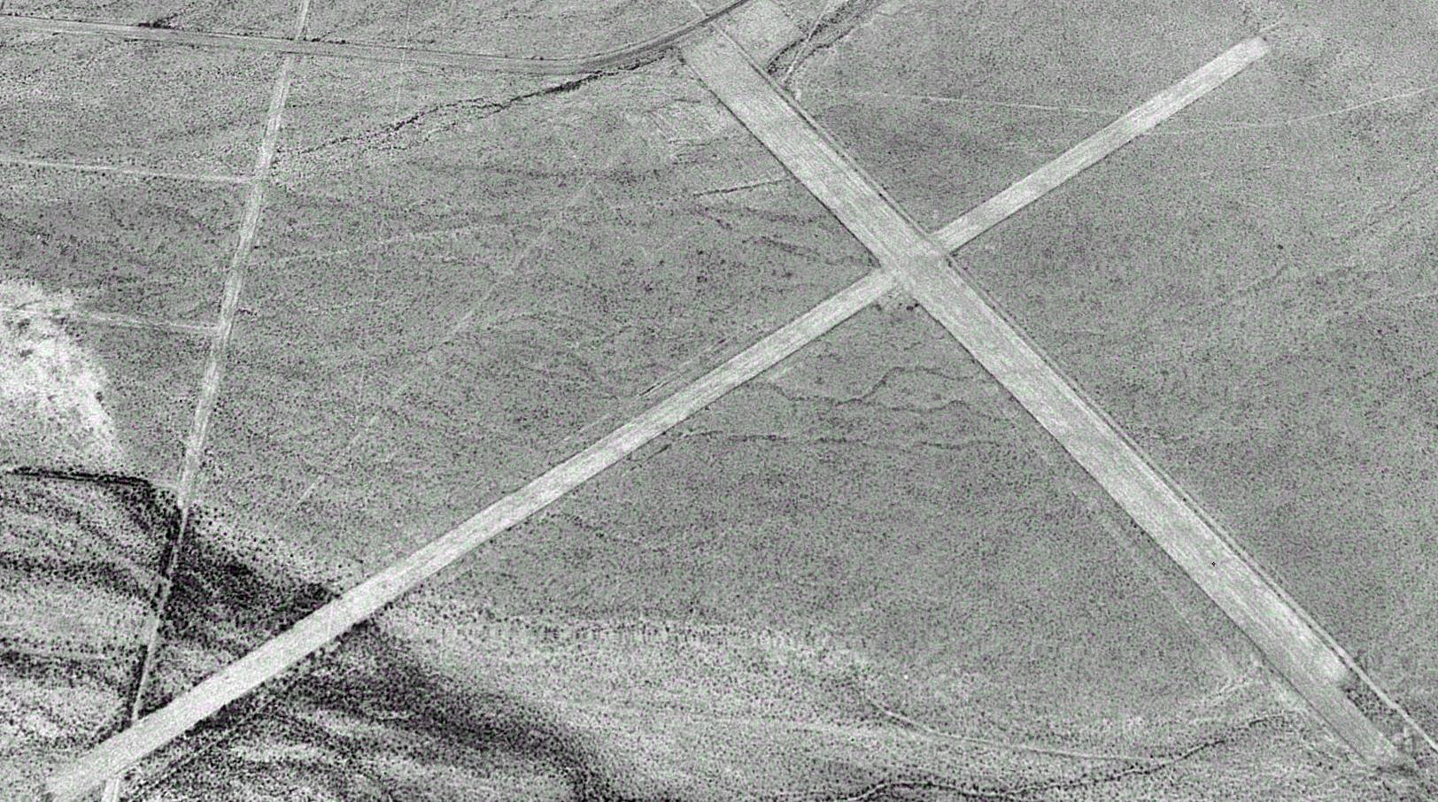
The earliest photo which is available of the Charleston View Airfield was a 1995 aerial view looking north.
It depicted 2 perpendicular unpaved runways, with no other improvements, or any indication of recent aviation use.
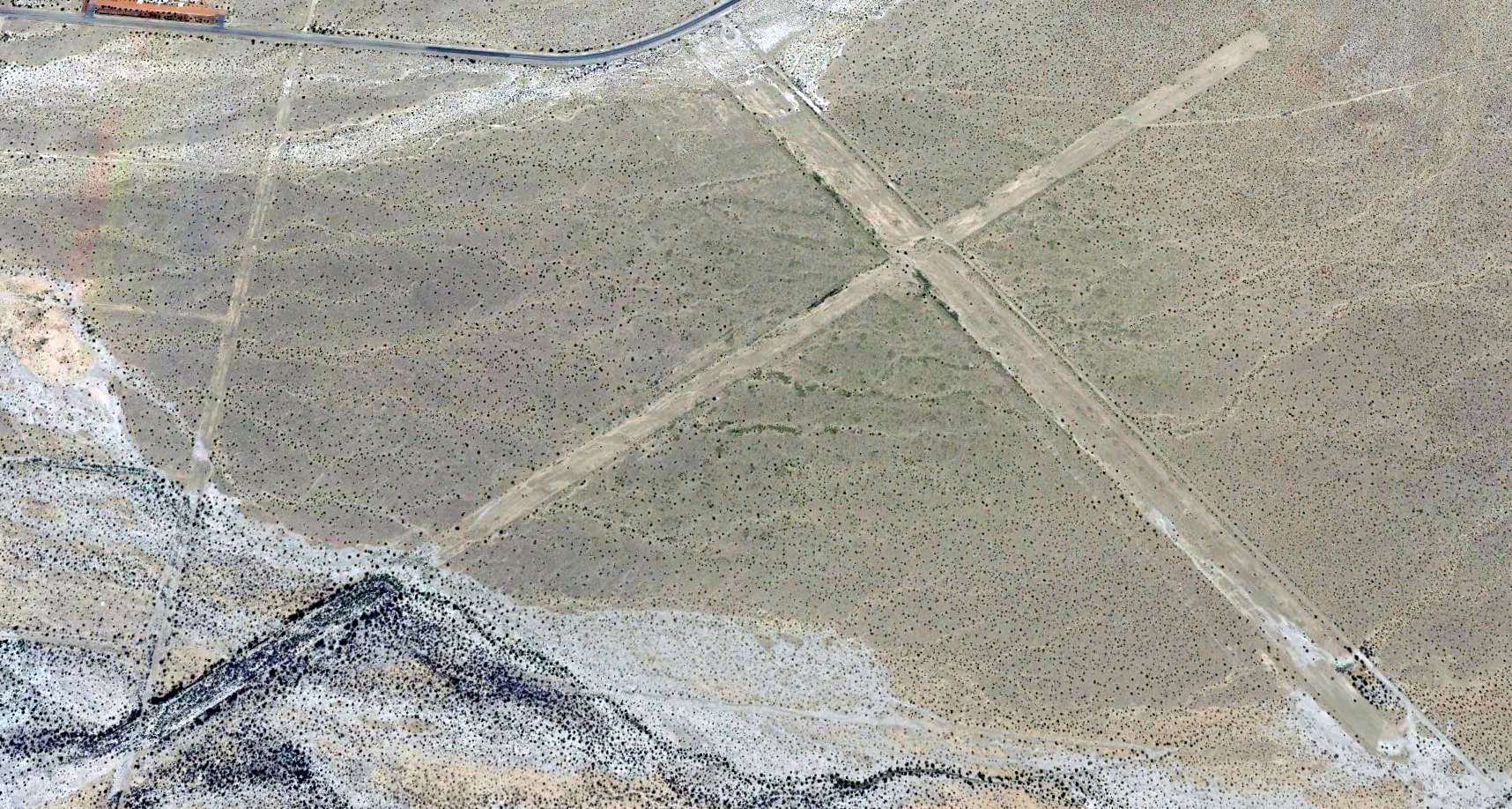
A 2019 aerial view looking north showed the 2 Charleston View Airfield runways to remain recognizable though deteriorated.
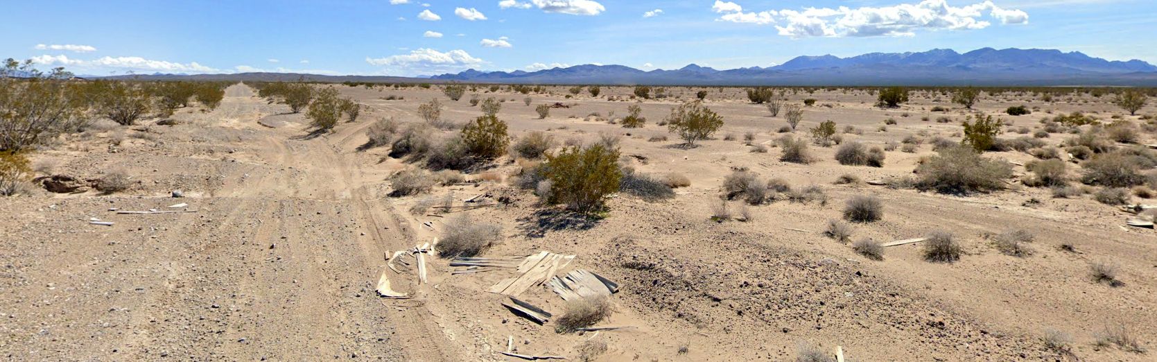
A 2023 photo looking southeast along the former Charleston View Airfield northwest/southeast runway.
Thanks to Lenny David for pointing out this airfield.
____________________________________________________
Death Valley Airport (original location) / Furnace Creek Airport, Death Valley, CA
36.46, -116.864 (Northeast of Los Angeles, CA)
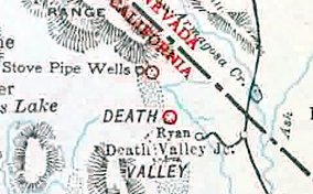
Death Valley Airport, as depicted in the 1931 Landing Fields of the Pacific (courtesy of Jonathan Westerling).
Jonathan Westerling reported, “The Furnace Creek Airfield was constructed to attract visitors from LA as an addition to what is now the Furnace Creek Inn.
Originally owned by the Pacific Coast Borax Company, the large ranch with grapes & date trees also served as a tourist destination.
One source stated that the Furnace Creek Airfield was constructed in 1926, however no reliable documentation of the airport has been found prior to 1929.”
The earliest reference which has been located to Furnace Creek Airfield was in an addendum to the 1929 Landing Fields of the Pacific West (according to Jonathan Westerling).
The earliest depiction which has been located of Furnace Creek Airfield was in the 1931 Landing Fields of the Pacific West (courtesy of Jonathan Westerling).
Jonathan Westerling reported, “The area became a National Monument in 1933, however the Inn & Airport remained private.”
The 1935 Death Valley National Monument Annual Report stated, " A notable fact was that 87 airplanes,
carrying 238 passengers, landed at the monument airport at Furnace Creek during the season."
The earliest aeronautical chart depiction which has been located of Death Valley Airport was on the February 1936 Sectional Chart (courtesy of Jonathan Westerling).
It depicted Death Valley as an auxiliary airfield.
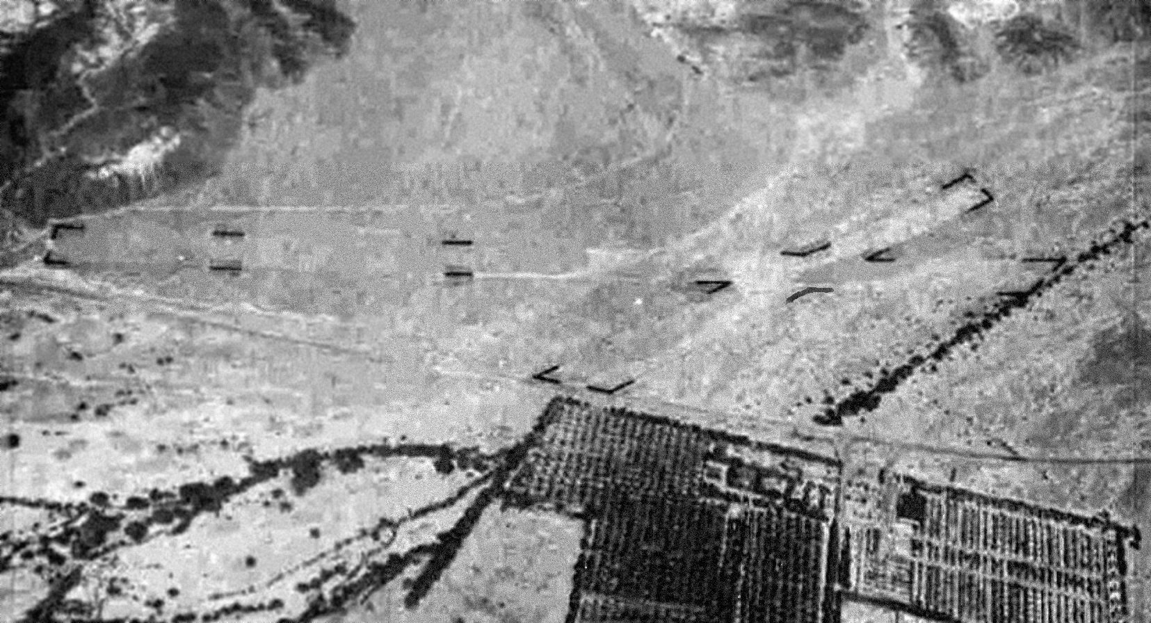
The earliest photo which has been located of Death Valley Airport was a 1936 Spence Air Photos aerial view looking southeast (courtesy of Jonathan Westerling).
It depicted Death Valley Airport as having 2 unpaved runways, with Furnace Creek Ranch at the right.
Death Valley Airport, as depicted on a 1937 road map (courtesy of Kevin Walsh).
A 1939 Spence Air Photos aerial view looking southeast at Death Valley Airport (courtesy of Jonathan Westerling).
An 8/1/43 USAAF aerial view looking east from the 1945 AAF Airfield Directory (courtesy of Scott Murdock)
depicted Death Valley National Monument Airport as having 2 unpaved runways.
The 1945 AAF Airfield Directory (courtesy of Scott Murdock) described Death Valley National Monument Airport
as having 2 gravel runways, measuring 2,800' north/south & 2,100' northwest/southeast.
It was said to have a 75' x 45' wooden hangar, to be owned by public domain, but not currently in operation.

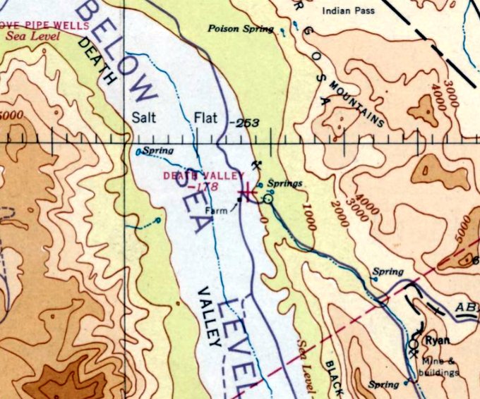
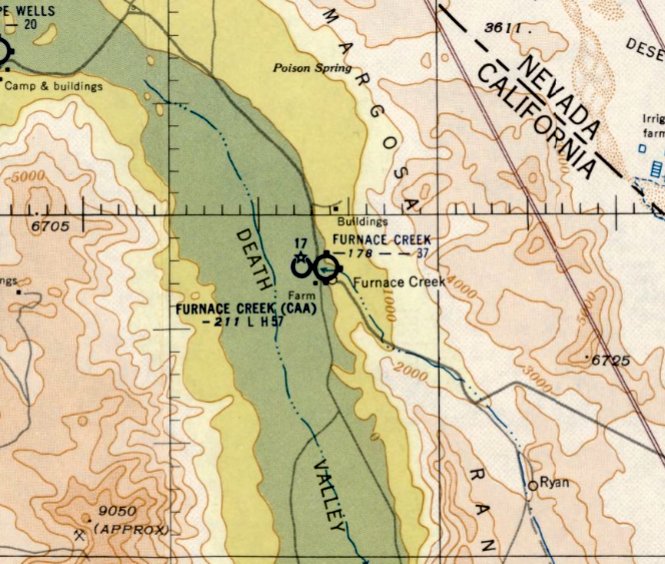
Death Valley National Monument Airport, as depicted on the 1948 USGS topo map (courtesy of Jonathan Westerling).
Jonathan Westerling reported, “The airport continued to serve visitors until a paved runway airfield began construction in 1953 on the other side of Route 190.”
A 1953 road map (courtesy of Kevin Walsh) only depicted the new airport on the west side of the road.
The last aeronautical chart depiction which has been located of Furnace Creek Airport was on the March 1954 Sectional Chart (courtesy of Jonathan Westerling).
It depicted Furnace Creek Airport as having a 3,700' unpaved runway.
Note that it also depicted the replacement “Furnace Creek (CAA)” airport across the road to the west.
Jonathan Westerling reported, “Interestingly, both airports existed for a time apparently due to issues with the new airport's runway causing it to be listed as a 'hazard'.
This was undoubtedly due to the intense summer heat which would cause normal pavement to go soft & harm landing aircraft.
Even several years after its construction, the newer airfield was still unable to support anything more than single-engine aircraft according to period NOTAMs.
Regardless, the original airport location disappeared from charts in 1955.
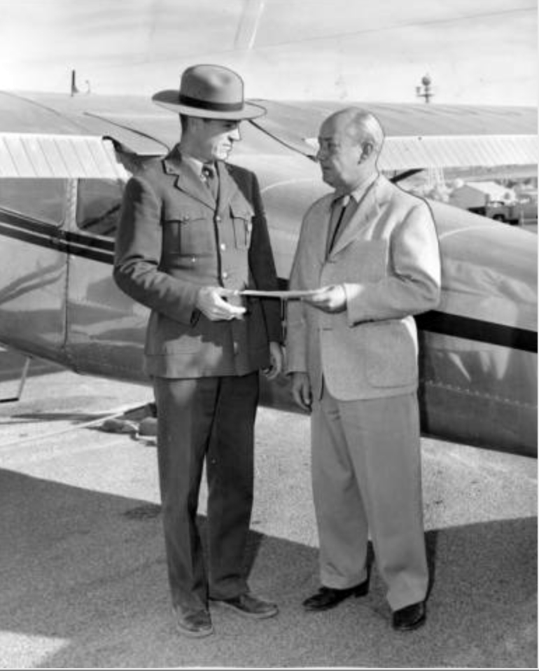
A 1956 photo from the Valley Times (courtesy of Jonathan Westerling) was entitled "Trade for lowest airport",
which apparently showed the official transfer of the "Lowest airport in North America" title to a ranger from the Park Service.
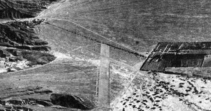
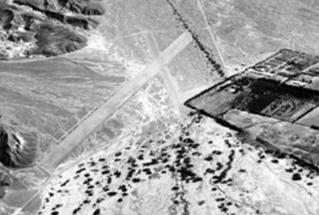
A 1989 USGS aerial view showed a parking lot had been built over the center of the original Furnace Creek Airport,
but the remains of the north end of the runway still existed.
A 2015 aerial view looking northeast at the site of the original Furnace Creek Airport showed paved parking lots had been built over the runway remains.
Thanks to Jonathan Westerling for pointing out this airfield.
____________________________________________________
Panamint Spring Auxiliary Airfield, Panamint Springs, CA
36.37, -117.41 (Northeast of Los Angeles, CA)
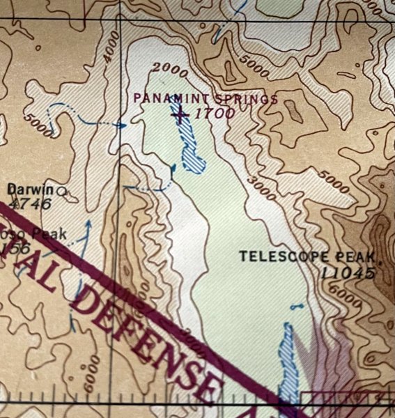
Panamint Springs Auxiliary Airfield, as depicted on the 1943 Mt. Whitney AAF Sectional Chart (courtesy of Kevin Walsh).
The date of establishment or purpose of this remote airfield has not been determined.
The earliest depiction which has been located of Panamint Springs Auxiliary Airfield was on the 1943 Mt. Whitney AAF Sectional Chart (courtesy of Kevin Walsh).
It depicted Panamint Springs as an auxiliary airfield in the middle of the northern portion of an unlabeled dry lakebed.
Curiously, the 1945 Mt. Whitney AAF Sectional Chart (courtesy of Kevin Walsh) depicted Panamint Springs Auxiliary Airfield in a slightly different location than the 1943 chart,
about a mile to the west, off of the dry lakebed.
Did the airfield actually move, or was this an unintentional lack of precision, or an example of an intentional WW2-era error?
No airfield at Panamint Springs was depicted on a 1947 aerial photo or the 1948 USGS topo map.
Panamint Springs Auxiliary Airfield was evidently abandoned (for reasons unknown) at some point between 1945-54,
as no airfield at Panamint Springs was depicted on the 1954 or 1959 Mt. Whitney Sectional Charts (courtesy of Kevin Walsh).
A 2013 aerial view looking west showed no trace of Panamint Springs Auxiliary Airfield.
Thanks to Kevin Walsh for pointing out this airfield.
____________________________________________________
Panamint Springs Airport, Panamint Springs, CA
36.338, -117.468 (Northeast of Los Angeles, CA)
An 8/26/89 USGS aerial view of Panamint Springs Airport (from the UCSB Library).
According to the Panamint Springs Resort website, “Panamint Springs Resort was originally owned & operated by Buffalo Bill Cody’s cousin, Agnes Cody.
The motel was opened in 1937 when the first toll road was constructed traversing the Panamint Valley. A post office operated at Panamint Springs from 1940-46.”
No airfield at Panamint Springs was depicted on a 1947 aerial photo, USGS topo maps from 1948-86,
or the 1959 Mt. Whitney Sectional Chart.
At some point between 1947-89 an unpaved runway was constructed on the south side of Panamint Springs.
The earliest depiction which has been located of Panamint Springs Airport was an 8/26/89 USGS aerial photo (from the UCSB Library),
which depicted a single unpaved northeast/southwest runway.
There did not appear to be any hangars or other airfield improvements.
A 1995 USGS aerial view looking northeast depicted Panamint Springs Airport as having a single unpaved northeast/southwest runway.
There did not appear to be any hangars or other airfield improvements, nor any aircraft visible on the field.
No airfield at Panamint Springs was depicted on the 2000 Las Vegas Sectional Chart.
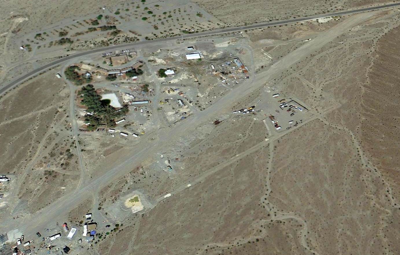
A 2013 aerial view looking northeast at the Panamint Springs Airport.
A 2/28/16 photo by Todd Schultz of the Panamint Springs Airport runway.
Todd reported, the “Runway is in good shape with some dips but otherwise smooth.”
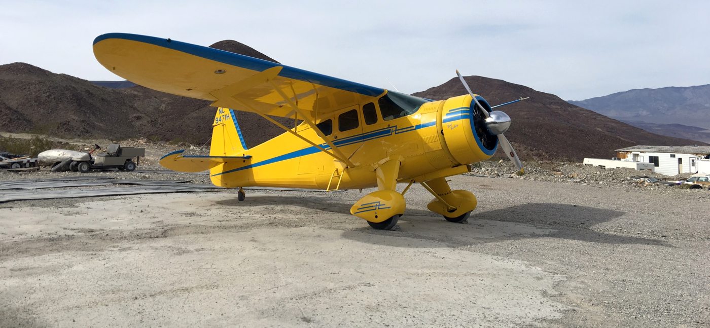
A 2/28/16 photo by Todd Schultz of his beautiful Howard at the Panamint Springs Airport.
Todd reported, “There is a little parking & turnaround on the west end. The owners are very friendly to aircraft & fly ultralights themselves.”
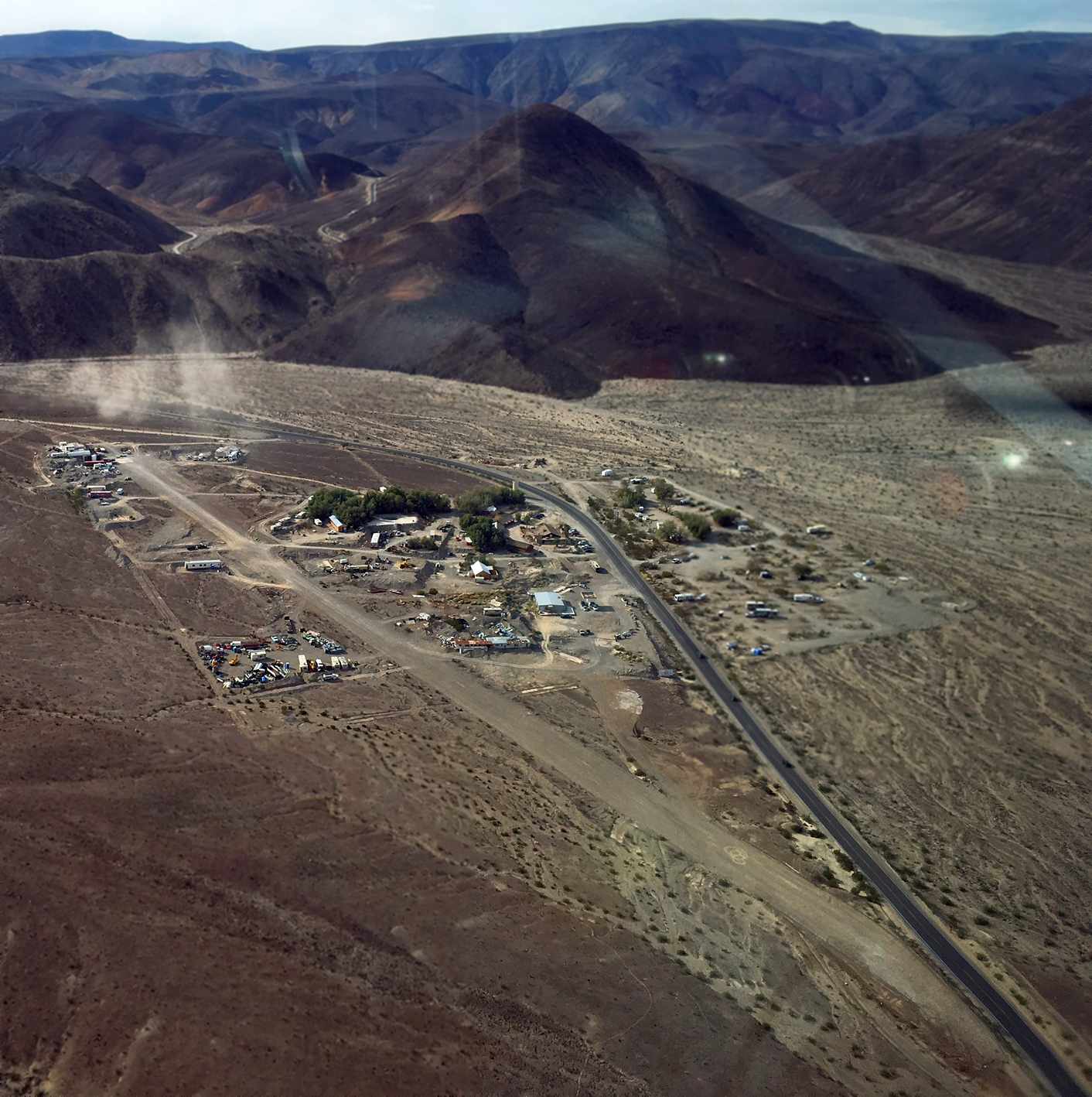
A 2/28/16 aerial view by Todd Schultz looking west at the Panamint Springs Airport.
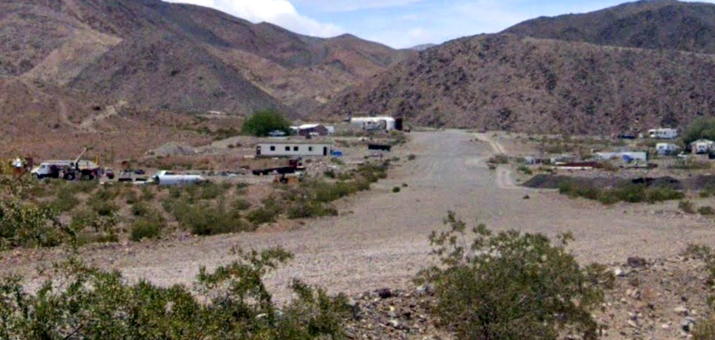
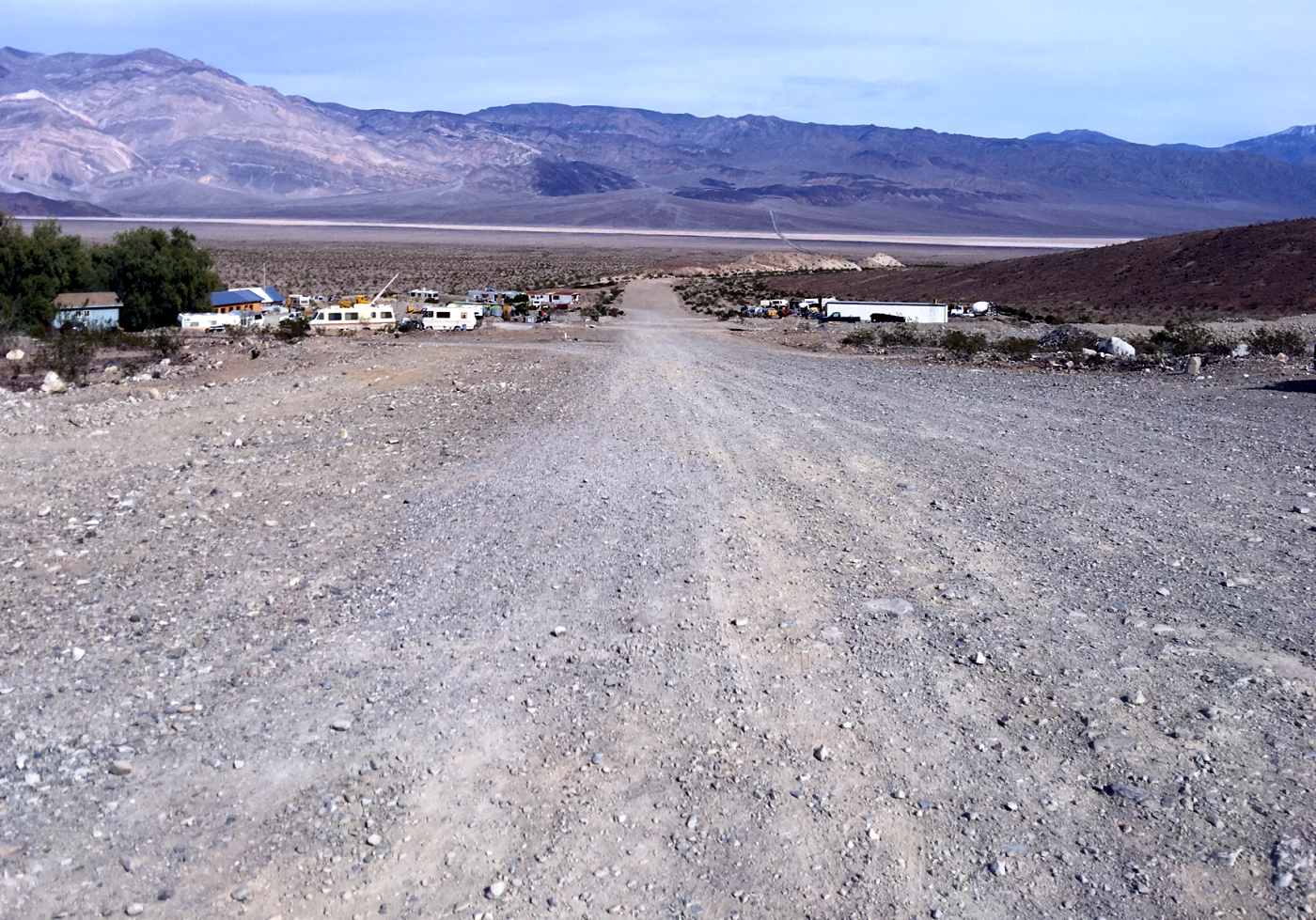
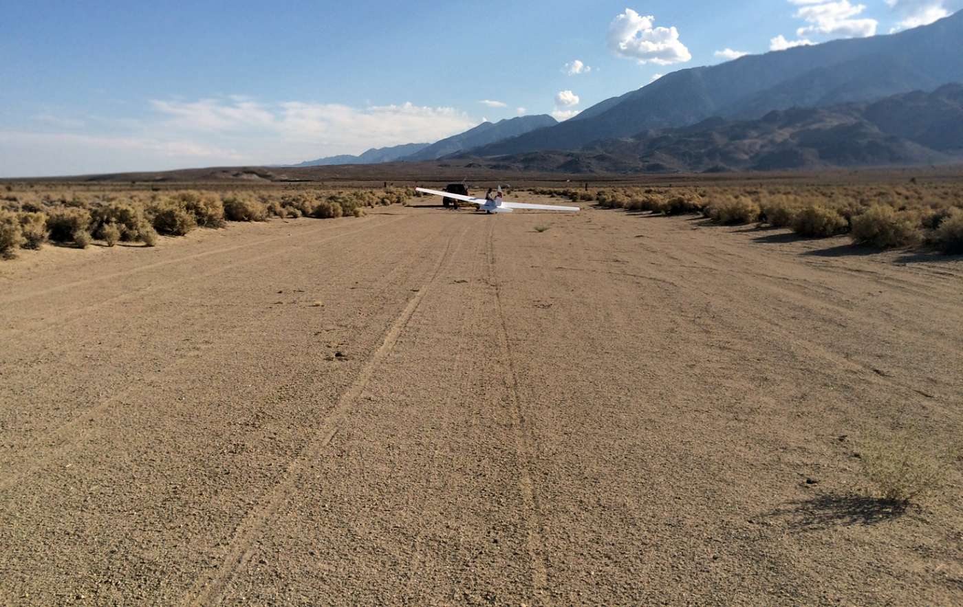
A 2023 photo looking southwest along the Panamint Springs Airport runway.
Panamint Springs Airport is located on the south side of Route 190, west of Panamint Valley Road.
Thanks to Todd Schultz for pointing out this airfield.
____________________________________________________
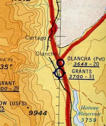
Grant Airport / Grants Airport / Grants Airpark / Olancha Strip, Grant, CA
36.256, -117.998 (North of Los Angeles, CA)
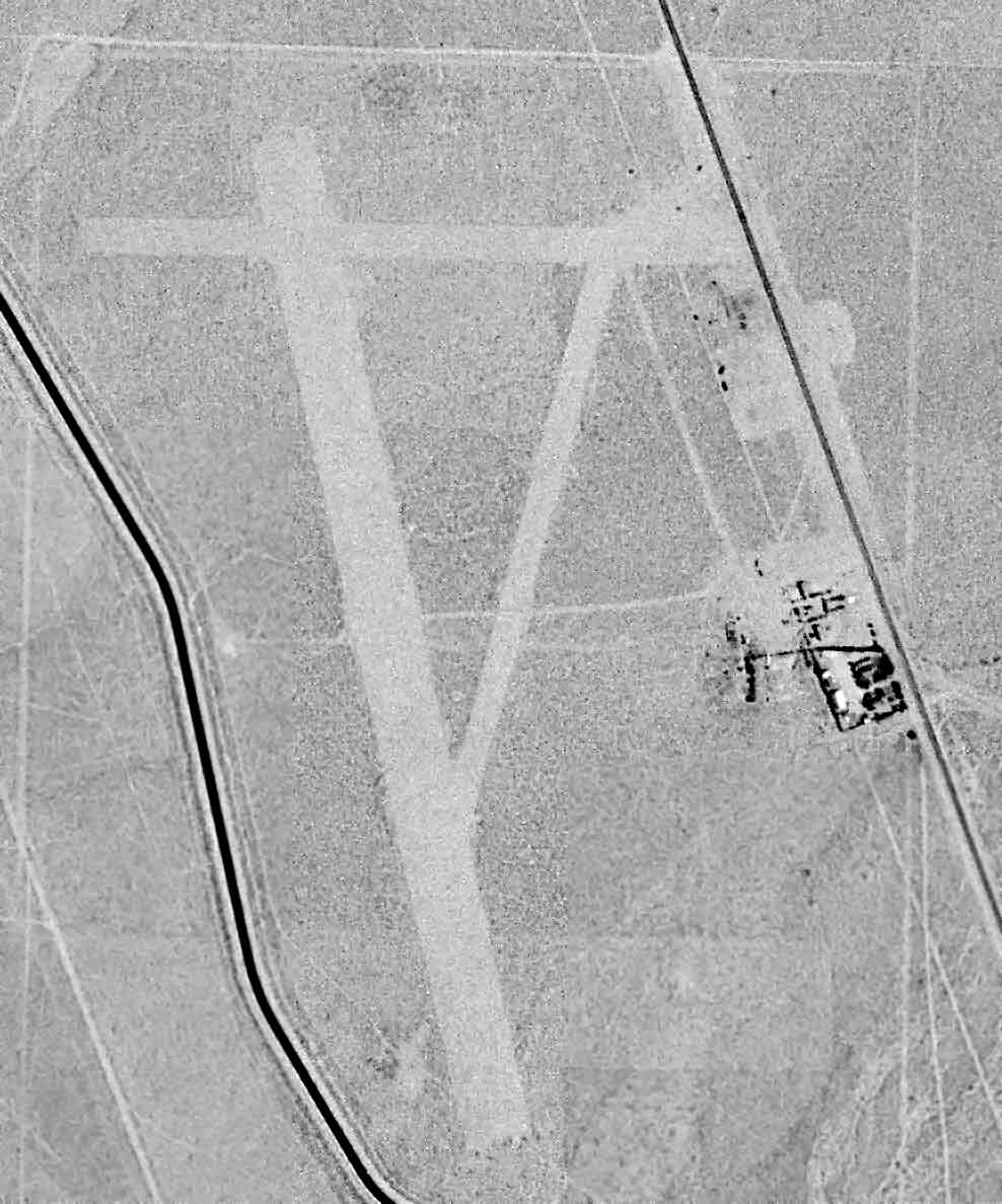
Grant Airport, as depicted on a 7/16/47 USGS aerial photo (enhanced by Bill Grasha).
This small airport may have been established at some point between 1945-47,
as it was not yet listed among active airfields in the 1945 AAF Airfield Directory (courtesy of Scott Murdock).
The earliest depiction which has been located of Grant Airport was on a 7/16/47 USGS aerial photo,
which depicted it as having 3 unpaved runways on the west side of Route 395.
There did not appear to be any hangars or other airfield improvements, nor any aircraft visible on the field.
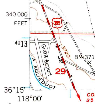
The 1951 USGS topo map depicted Grant Airport as having 3 runways, with several small buildings along the east side.
The earliest aeronautical chart depiction which has been located of Grants Airport was on the May 1957 Mt. Whitney World Aeronautical Chart.
It depicted Grants as having a 3,100' unpaved runway.
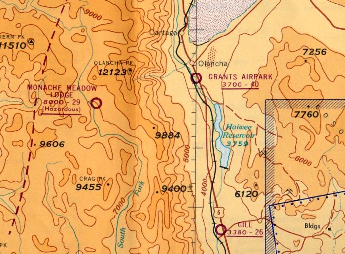
The last aeronautical chart depiction which has been located of Grants Airpark was on the October 1962 Mt. Whitney Sectional Chart (courtesy of Paul Columbus).
It depicted Grants Airpark as having a 4,000' unpaved runway.
Todd Schultz recalled, “My dad said he remembers flying there in the late 1960s or 1970s with a friend to do an annual on someone who based a plane at Grants.”
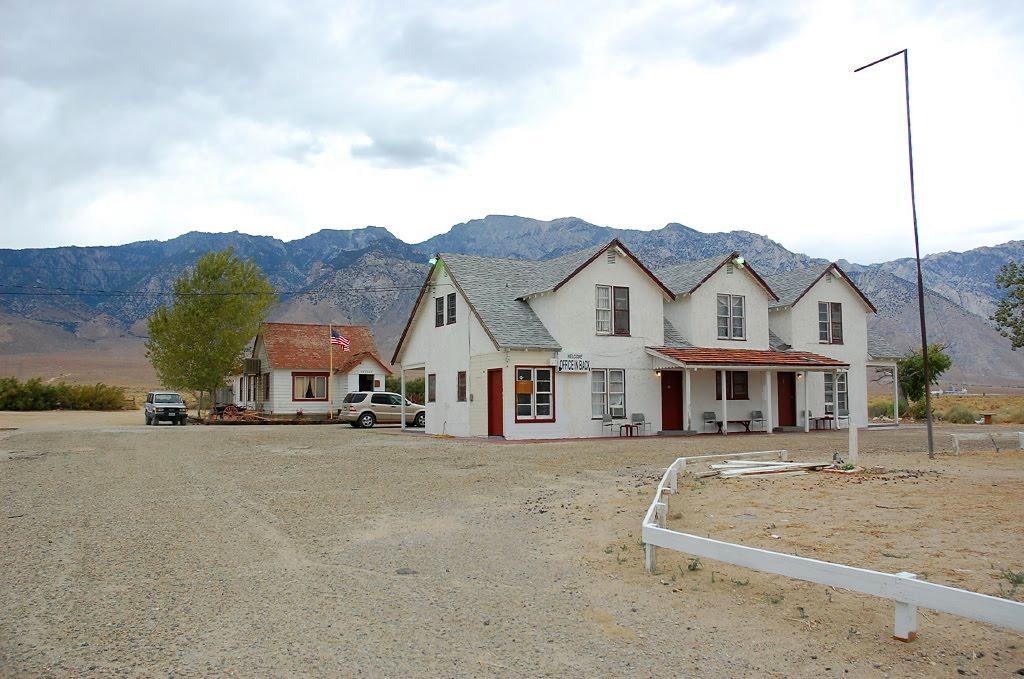
A 2011 photo (courtesy of Leigh Kelly) of the Ranch Motel, which sits adjacent to the east side of Grant Airport.
Leigh Kelley reported in 2014, “My chiropractor told me about running across a fascinating place in the middle of nowhere on US-395.
He had needed to stop for the night on his way to Mammoth Mountain years ago & the first place he saw was a white 2-story house called the Ranch Motel.
He said that there was nothing else around it. There had been a community there called Grant.
The manager told him that the house had once been a hunting lodge that had belonged to Howard Hughes & there is a dirt strip behind the motel.”
A 5/25/13 aerial view looking northwest showed the Grant runways remained intact.
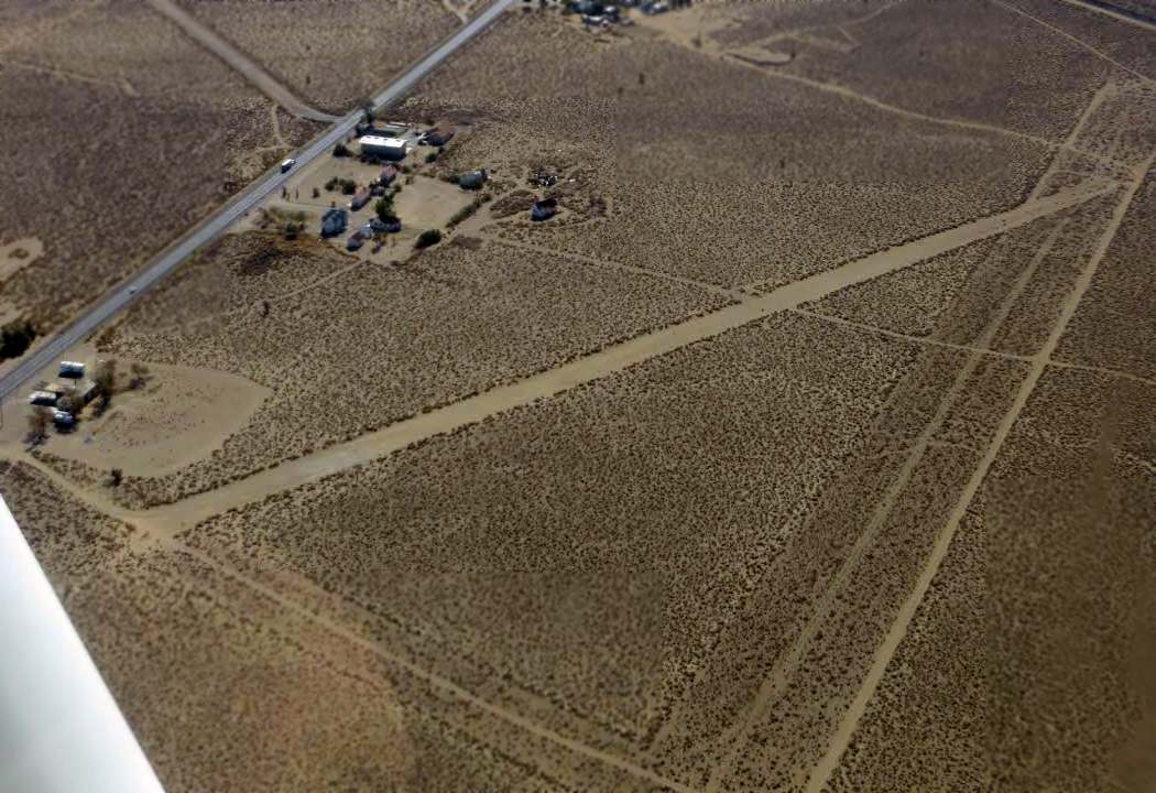
An October 2014 aerial view by Dustin Mosher looking southeast showed the Grant runways remained intact.
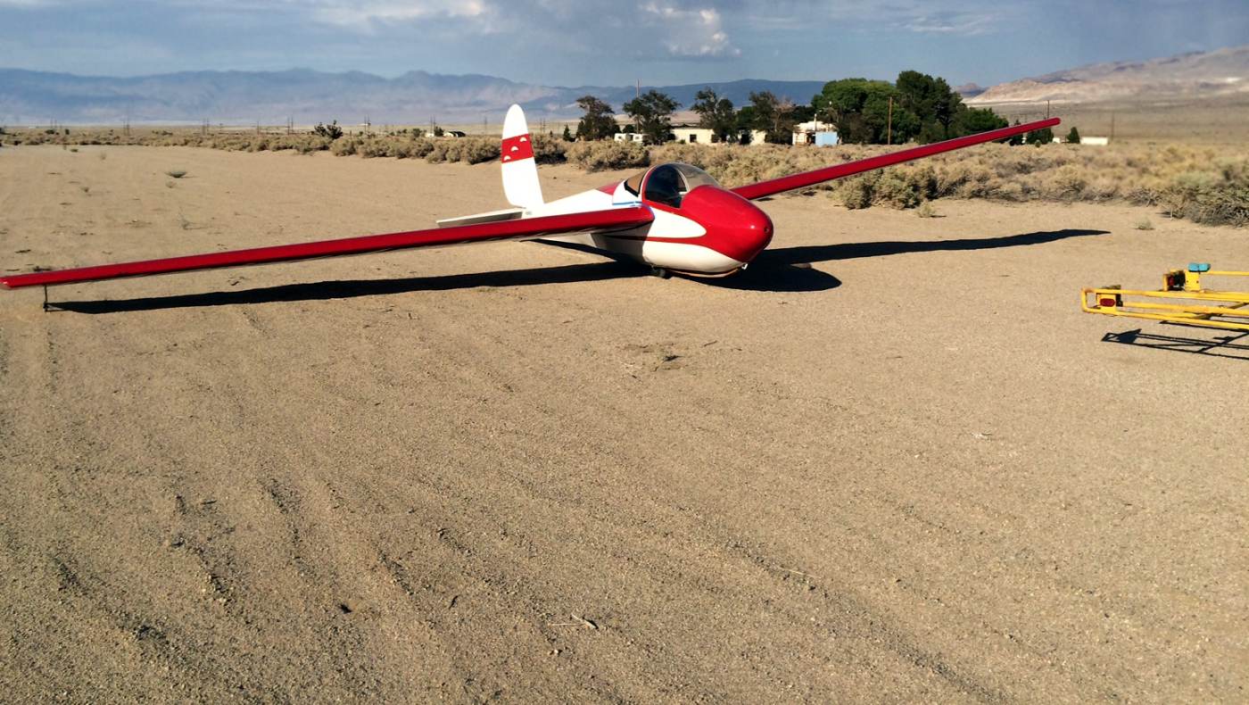
A 9/14/15 photo by Todd Schultz of his 1964 Schweizer 1-26b glider “that I restored over the last few years” on the Grants Airport runway.
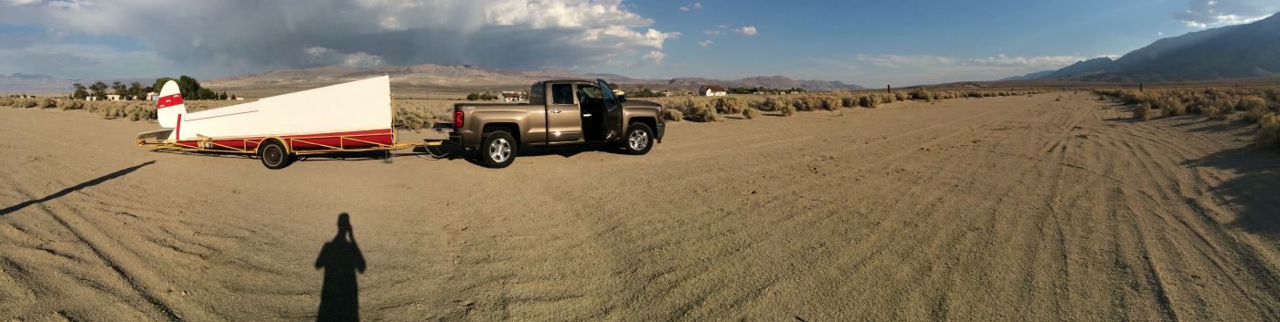
A 9/14/15 panoramic photo by Todd Schultz of of his 1964 Schweizer 1-26b glider at Grants Airport.
Todd observed, “The runway is in good shape & is slightly soft.
Bushes are starting to take over the south end. We use it as an auxiliary landing field for sailplane flying along the Sierras.
We all know it as the Olancha Strip now.”
A 9/14/15 photo by Todd Schultz of his 1964 Schweizer 1-26b glider on the Grants Airport runway.
Grants Airport is located west of the intersection of Route 395 & Cactus Flats Road.
Thanks to Leigh Kelly for pointing out this airfield.
____________________________________________________
Adamson Airport / Olancha Airport, Olancha, CA
36.28, -118 (North of Los Angeles, CA)
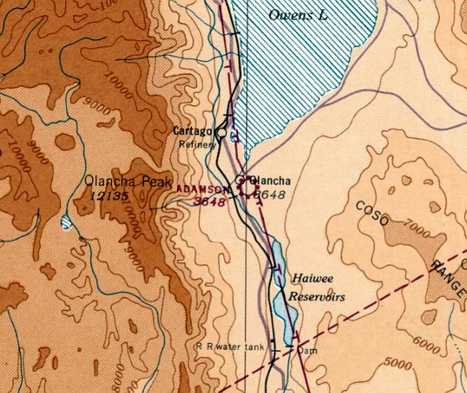
Adamson Airport, as depicted on the July 1942 Mt. Whitney Sectional Chart.
Adamson Airport was evidently established at some point between 1941-42,
as it was not yet depicted on the August 1941 Mt. Whitney Sectional Chart.
The earliest depiction of Adamson Airport which has been located was on the July 1942 Mt. Whitney Sectional Chart.
It depicted Adamson as a commercial/municipal airport.
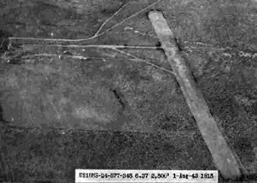
The earliest photo which has been located of Adamson Airport was a 8/1/43 aerial view looking north from the 1945 AAF Airfield Directory (courtesy of Scott Murdock).
It depicted Adamson as having 2 unpaved runways.
The 1945 AAF Airfield Directory (courtesy of Scott Murdock) described Adamson as a civil airport consisting of a 160 acre irregularly-shaped property
having 2 bladed runways, measuring 2,700' north/south & 1,000' east/west.
The field was said to not have any hangars, and to be owned & operated by private interests.
The 1945 Mt. Whitney World Aeronautical Chart depicted Adamson Airport as an auxiliary airfield.
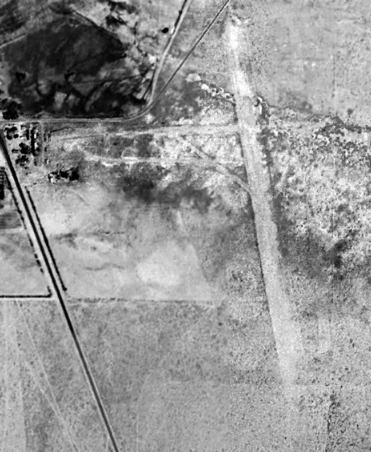
A 7/16/47 USGS aerial view (enhanced by Bill Grasha) depicted Adamson as having 2 unpaved runways.
No aircraft were visible on the field.
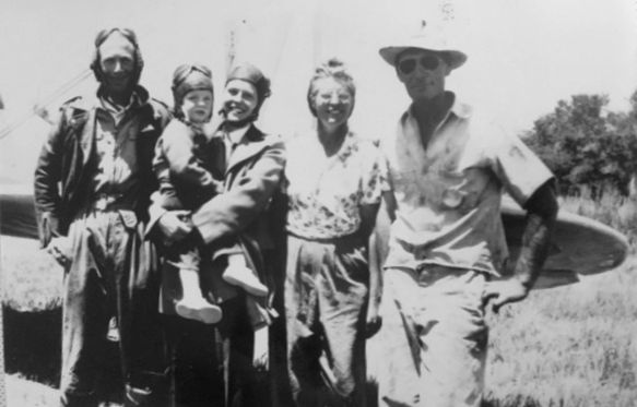
A 1947 photo of a family reunion at Adamson Field (courtesy of Ken Harbison).
According to Ken Harbison, “Left to right: My father, Raymond Harbison, my mother, Kathleen Harbison, she is holding my older brother John Harbison.
John & Claire Storm, lifetime Olancha residents, my grandparents. The aircraft, a Stearman, belonged to Sutter Air Industries, my dad's cropdusting business.”
The 1948 Mt. Whitney World Aeronautical Chart depicted Adamson as an auxiliary airfield.
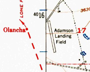
The 1951 USGS topo map depicted Adamson Landing Field as having a single northwest/southeast runway.
There were no buildings depicted at the airport.
It was still depicted as Adamson Airport on the March 1952 Mt. Whitney Sectional Chart.
Adamson Airport was evidently renamed Olancha Airport in 1952,
as that is how it was labeled on the September 1952 Mt. Whitney Sectional Chart.
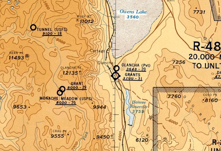
The last aeronautical chart depiction which has been located of Olancha Airport was on the September 1957 Mt. Whitney Sectional Chart.
It depicted Olancha as a private airfield having a 2,000' unpaved runway.
Olancha Airport was evidently abandoned (for reasons unknown) at some point between 1957-58,
as it was no longer depicted on the March 1958 Mt. Whitney Sectional Chart.
According to Ken Harbison, “At some point Adamson was replaced by JG Grants Airstrip just south of town on Highway 395.”
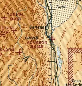
The 1985 USGS topo map still depicted a single northwest/southeast runway, labeled simply “Landing Strip”.
Adamson Airport was no longer depicted on the 1987 USGS topo map.
A 1994 USGS aerial view showed that a waterskiing basin had been built over the northern portion of the Adamson Airport site.
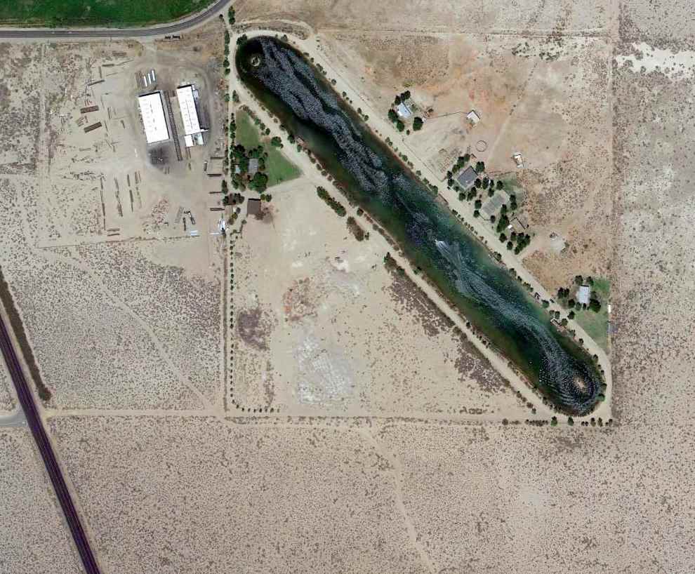
A 5/25/13 aerial view showed a waterskiing basin covering the northern portion of the Adamson Airport site, with only faint traces remaining of the southeastern portion of the former runway.
The site of Adamson Airport is located southeast of the intersection of Route 190 & Route 395.
____________________________________________________
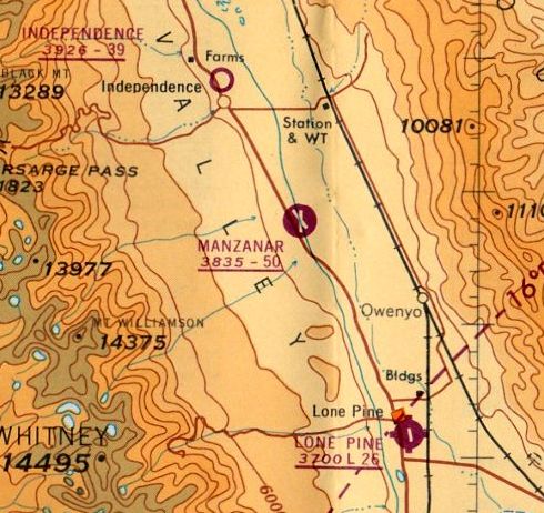
Inyo County Airport / Manzanar Airport, Manzanar, CA
36.735, -118.146 (East of Fresno, CA)
An 8/1/43 aerial view looking east at “Inyo County Airport”
from the 1945 AAF Airfield Directory (courtesy of Scott Murdock).
According to the 2003 paper "Airports of the Owen Valley" by Kirt Nance (courtesy of Peter Tracy),
"In early 1941 the Government contacted Inyo County & awarded over $500,000 to update valley airports,
so that they would fall into National Defense Airway standards.
Also in this package were monies & instructions to build an airport at Manzanar.
This airport would have runways 5,300' in length, and would include runway lights & a beacon.
The City of Los Angeles [Department of Water & Power] would lease the land to the government for 50 years,
and it would be for use by the public until such time that it would be needed by the military.
According to the US Department of the Interior publication Manzanar National Historic Site,
619 acres were leased; however the report claims the lease was never recorded."
According to an account by a National Park Service history of the Manzanar Camp,
the lease contained a provision that it would terminate automatically should the land
not be used for airport purposes for more than one year.
According to Keith Wood, "This was most certainly a 'fallback field'
[to be used by US forces in the event of a Japanese invasion of the West Coast].
They were to be run as tent cities, by forces who would fall back to the next 'ring' if necessary.
If they had to fall back, they didn't want to leave a lot of facilities to an invader.
Support would have been by the rail line.
Some fields were intended primarily for fighters & medium bombers,
while others were designed to handle the staging of heavy bombardment groups,
who might be based deeper in the interior, then move to forward bases only for rearmament & refueling for short sorties.
Repairs would be done at the home bases, such as Wendover (Utah) or March Field (Riverside, CA)."
Inyo County Airport was not yet depicted on the August 1941 Mt Whitney Sectional Chart.
The Manzanar airfield was adjacent to the site of one of the infamous "Wartime Relocation Centers",
to which civilians of ethnic Japanese background were relocated from 1942-1945.
Laurie Bush recalled, “I took a tour of the Internment camp [circa 2005].
There was an elderly gentleman in my group that was in the camp as a child.
He told me that the airstrip directly across Highway 395 from the camp was used to bring in supplies for the people being held there.”
According "Airports of the Owen Valley" by Kirt Nance (courtesy of Peter Tracy),
"By mid-May 1942… Manzanar Airport was the largest in the valley,
and would see planes as large as the B-24 landing there as crews geared up for the big push in the war."
The earliest depiction which has been located of Inyo County Airport
was an 8/1/43 aerial view looking east from the 1945 AAF Airfield Directory (courtesy of Scott Murdock).
It depicted the field as having 2 paved runways.
The earliest aeronautical depiction which has been located of the Inyo County Airport
was on the 1943 Mt Whitney Sectional Chart (according to Chris Kennedy).
A 1943 photo looking west-southwest at the Manzanar flightline (courtesy of Craig Thorson, enhanced by Bill Grasha),
with what appear to be Taylorcrafts in front of a hangar & operations building.
The snowcapped Sierra Nevada Mountains are visible in the background,
and the tarpaper barracks of the Manzanar Relocation are visible just above the planes on the left.
Craig Thorson recalled, “While Manzanar may have indeed been constructed as a 'fallback field'
it was definitely used to train pilots for the Civilian Pilot Training Program (CPTP).
My father [Roy Thorson] was in the program at Manzanar beginning in March 1943.”
Gene deRuelle reported in 2017, “I am starting to restore a 1941 Interstate Cadet that may have been used for flight instruction
in the Spider Ross Flying School that was part of the Civilian Pilot Training Program out of Manzanar.”
The 1944 US Army/Navy Directory of Airfields (courtesy of Ken Mercer)
described Inyo County as having a 5,000' hard-surface runway,
and did not indicate that any military operations were conducted from the field.
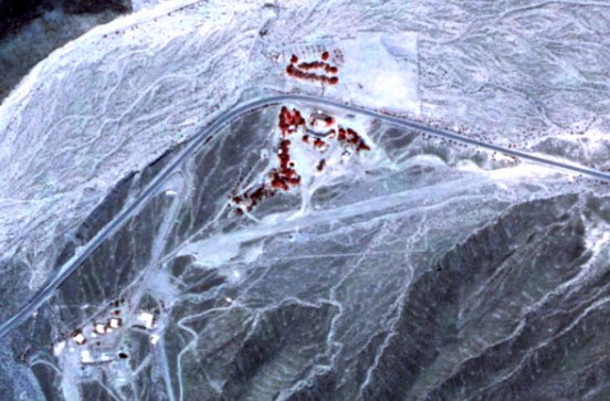
A 10/14/44 aerial view of Manzanar Field (from the UCSB Library, courtesy of Rick Jackson) also showed the multiple buildings of the Manzanar Internment Camp across the road at bottom-left.
A 10/14/44 aerial view of Manzanar Field (from the UCSB Library, courtesy of Rick Jackson) showed multiple light aircraft parked on the ramp to the west of the runway intersection,
along with one aircraft on the runway just to the southeast, and another in-flight just west of the south end of the runway.
Ed Lansberg recalled, "I took my first dual [flight instruction] there in November of 1944, during the war."
The 1945 AAF Airfield Directory (courtesy of Scott Murdock) described Inyo County Airport
as a 700 acre rectangular property having 2 bituminous 5,000 runways, oriented north/south & northwest/southeast.
The field was said to have a single 80' x 62' wooden & metal hangar,
to be owned by Inyo County, and operated by private interests.
The earliest aeronautical depiction which is available of the Inyo County Airport was on the September 1944 Mt Whitney Sectional Chart.
It depicted Inyo County Airport as an auxiliary airfield.
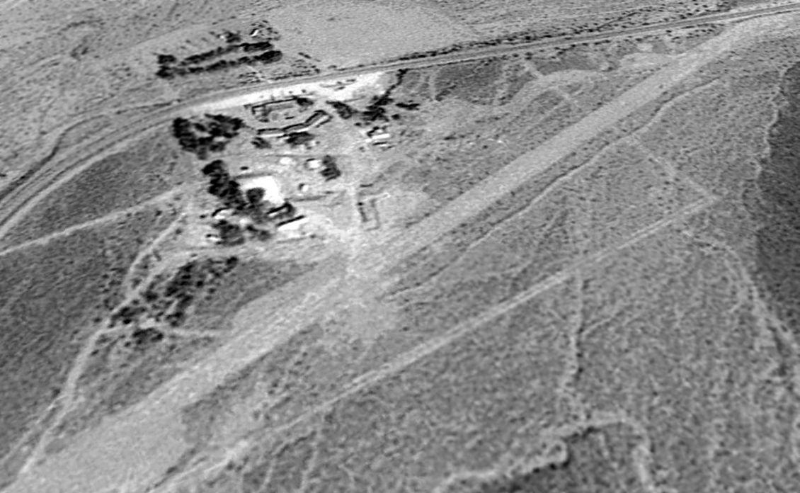
A 7/17/47 USGS aerial view (enhanced by Bill Grasha) depicted Inyo County Airport as intact though apparently not in use.
The 1949 Mt Whitney Sectional Chart (according to Chris Kennedy) described "Inyo County" Airport
as having a 5,000' hard-surface runway.
In 1956, Inyo County notified Los Angeles that it had abandoned the airport,
that the Civil Aeronautics Administration had consented to such abandonment & was not interested in the site,
and that the premises had not been used for airport purposes for more than one year.
In connection with the lease cancellation the county marked off the runways in 1956,
and the wind sock & tower were removed in 1957.
Thereafter, the land on which the former Manzanar airport had been located
was leased to local ranchers for grazing purposes & used for a variety of special events.
In 1957 the airport was used as a bivouac area for an advance party of the NV National Guard.
The Corps of Engineers indicated that it had no further interest in the airport,
and in 1958 work commenced to remove electrical equipment, including the obstruction lights.
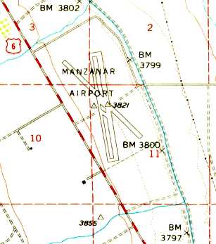
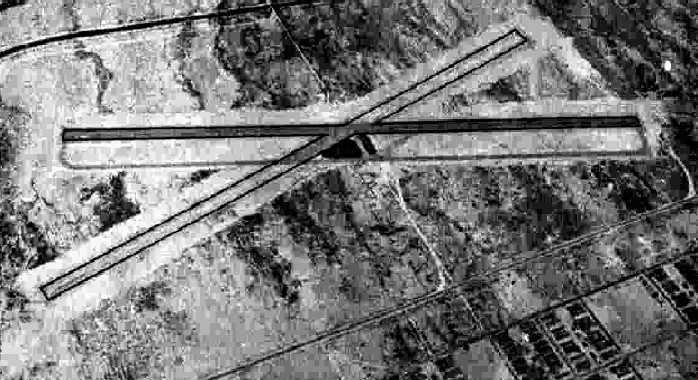
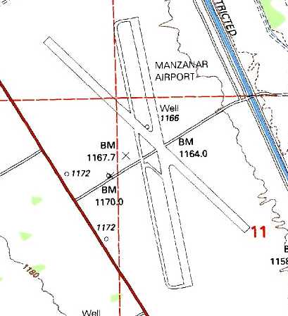
The 1958 USGS topo map depicted Manzanar Airport as having 2 paved runways & a parallel taxiway.
The October 1962 Mt. Whitney Sectional Chart (courtesy of Paul Columbus)
depicted Manzanar Airport as having 2 paved runways, with the longest being 5,000'.
From 1968-69, Aerojet General of Downey, California,
was granted permission to use the Manzanar Airport land & runways for experimental tests.
The Manzanar runways were used for automobile racing time trials starting in 1970,
according to Scott Aguilar (a member of the Lone Pine Time Trials Committee).
Lane Leonard reported, “It was 1975 or early 1976 when Roger Neff flew a Mercer Airlnes DC-3 into Manzanar with Captain Jim Seccom.
They picked up part of a movie crew that was filming a documentary on the Manzanar Camp.
It was probably the last large aircraft to land there. The runway was in excellent shape with just a ramp & wind sock.”
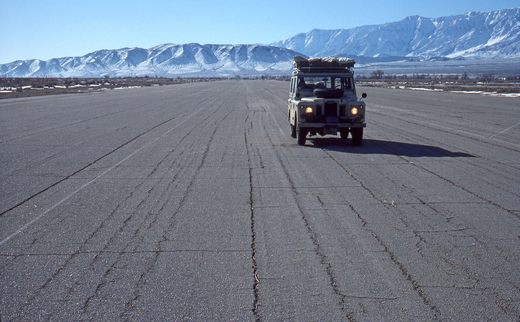
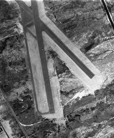
A February 1976 photo looking along a Manzanar Airport runway.
John Hazlet said in 2003, "I tend to go with the theory that Manzanar was built as a military field.
I made a 'forced' landing there in the mid-1970s
(I hit such a bad bump in unexpectedly turbulent conditions north of Lone Pine
that it deformed the fuselage in the BE-35 I was flying enough to pop the door open).
I dragged over the abandoned Manzanar field, but it looked like it was covered with rocks.
I got down a little lower, and the 'rocks' turned out to be cow pies.
The runway was otherwise in fine shape, so I landed (knocking the dry ones out of the way, and squishing through the fresher ones),
re-latched the door, and continued to BIH."
"While on the ground, I observed obviously well built reinforced concrete runways,
expensive runway lights (including heavy cast aluminum flush light units in the vicinity of the intersection),
and other signs that much more money had been spent on this airport
than would be likely for a remote, little-used county facility."
It was labeled "Manzanar Airport" on the 1994 USGS topo map.
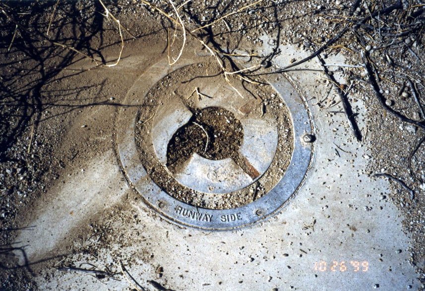
A 1999 photo by Rick Jackson of the remains of a Manzanar Field runway light.
Rick reported, “I also found a small parachute, possibly a jet drogue chute. You'd hear jets flying up & down the valley all day long.”
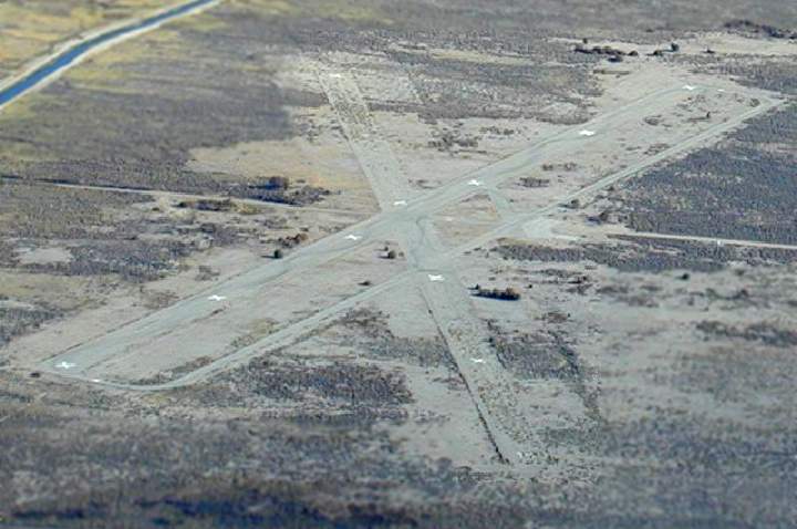
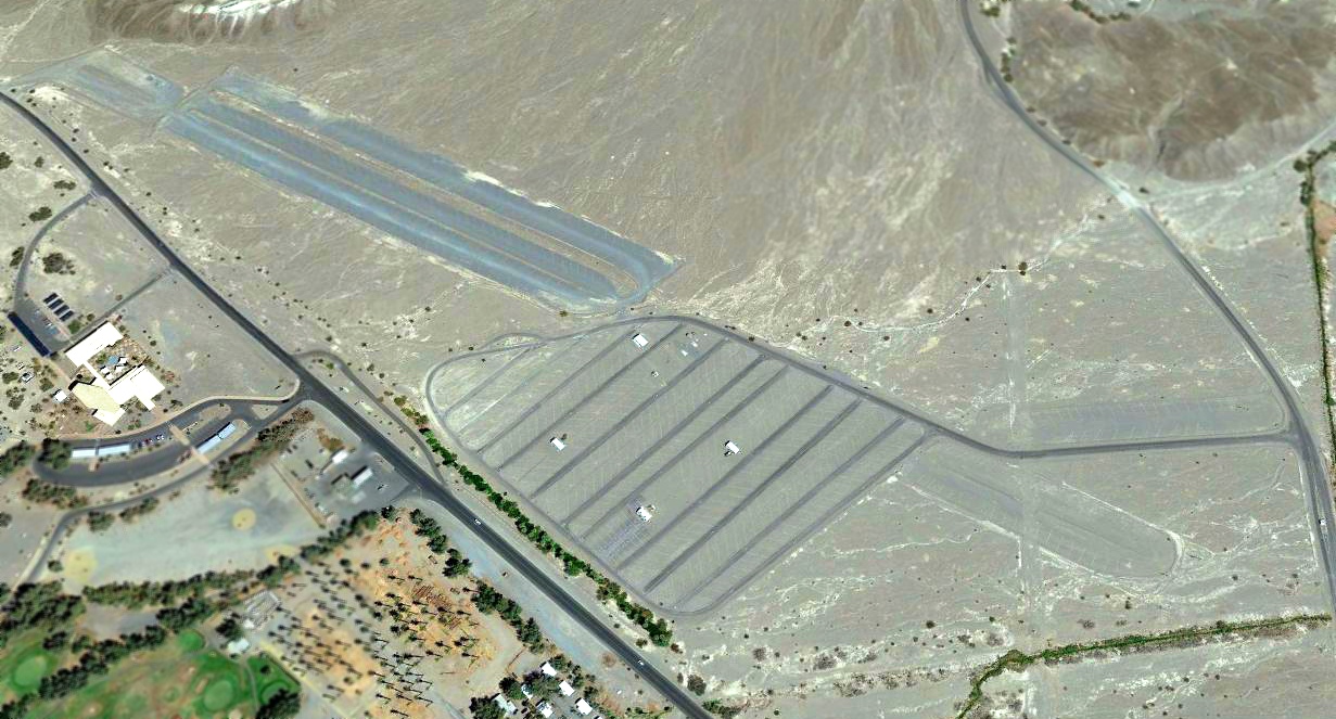
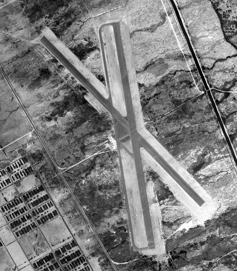
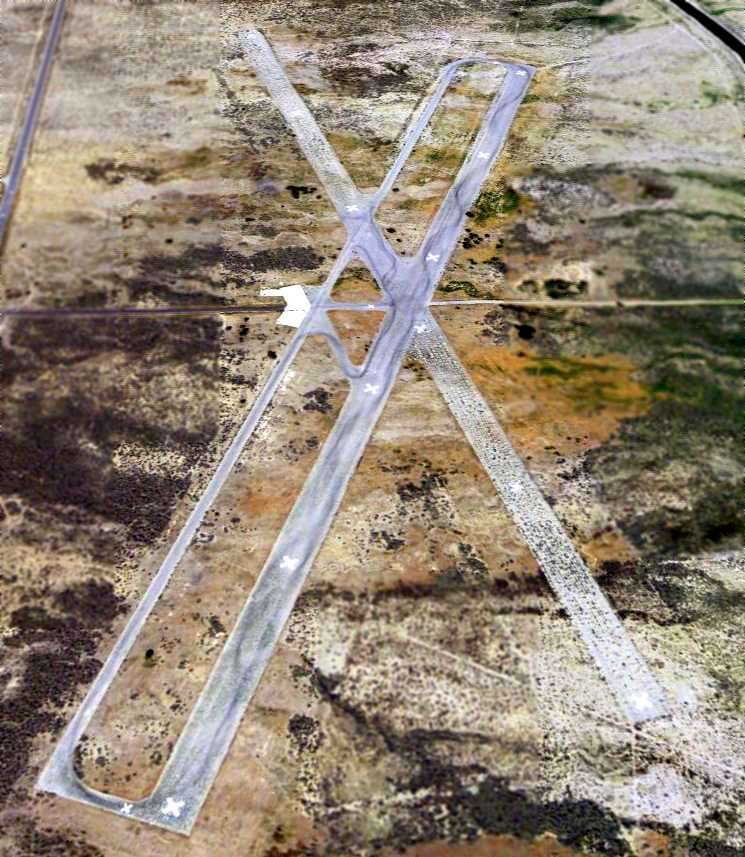
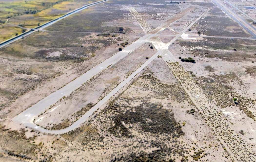
A 2001 aerial view by J.D. Lawson looking south at Manzanar Airport.
The airfield consists of two 4,800' paved runways, one of which has a parallel taxiway.
Both runways are still marked with "X" closed runway symbols.
A small paved ramp sits at the runway intersection, but all buildings had been removed.
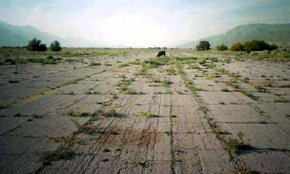
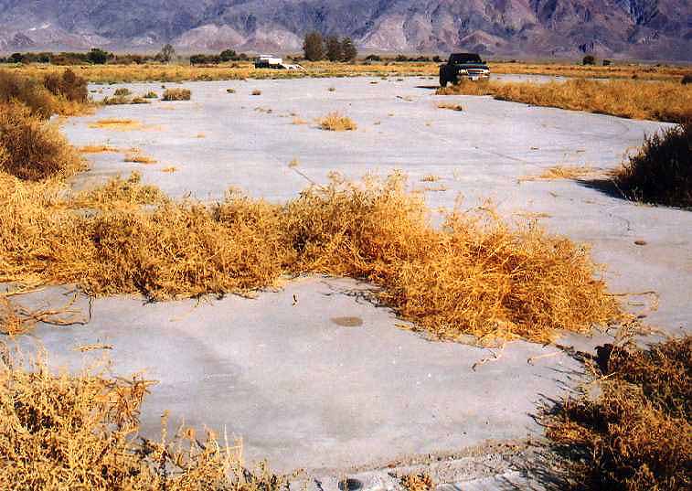
A circa 2000s picture of a solitary cow grazing on grass growing up through the cracks in the pavement of one of the runways at Manzanar (enhanced by Bill Grasha).
The field is still depicted as an abandoned airfield on 2002 aeronautical charts.
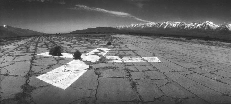
A beautiful 2002 panoramic photo by Larry Turoski, looking south from Manzanar's runway intersection.
A 2003 photo by Larry Turoski (enhanced by Bill Grasha) looking east at the apparent foundation of a former hangar at Manzanar.
Larry Turoski reported in 2003, "There are indeed 2 foundations left. One was, I'm certain, a hangar.
It is a raised slab of concrete attached to the parking ramp,
with a low berm between it & the ramp where I assume the hangar door was.
There is no evidence of tracks for the hangar doors. The entrance faces approximately due east.
There is an adjoining portion on the north side the slab that was, I presume, office or shop space.
Just to the north of this shop space is another small foundation that may have been an outbuilding, or a second office.
It was about 8' x 8'. I paced off the hangar floor area & it measured approximately 100' x 60',
with the 100' dimension running from front to back, i.e., east to west.
Etched into the parking ramp concrete immediately 'outside' the hangar was this: SN IG 6-26-42 RW."
Larry continued, "I found a USGS bench mark in the hangar foundation.
You can see the bench mark in the extreme foreground of the upper picture. The benchmark was dated 1952.
I gave the only structure a closer look & it indeed appears to have been an electrical or utility building of some sort.
There are conduits & openings in if where electrical lines could have passed through,
and the remnants of a large switch of the type one throws in circuits with lots of juice.
There was a second USGS benchmark cemented to the side of this building dated 1962, but I think the building predates that.
The parallel taxiway abuts against the parking ramp
and reinforces my opinion that it wasn't really a parallel taxiway, but space for extra parking.
The cement parking ramp has tie-down rings embedded in it, and they are huge.
They weren't for tying down Airknockers or Piper Cubs."
Chris Kennedy reported in 2003, "I stopped by the old Manzanar airfield.
If that was a military field,
I don't see how it could have been anything but an emergency strip because there isn't any parking area.
On the aerial photos you can see the very small concrete pad on the west side.
It has a few tie down rings, but it wouldn't have accommodated very many airplanes.
On the other hand, I don't know why Inyo County would build such a large airport in the middle of nowhere like that.
On the other hand, they used to film a lot of movies in that area.
Maybe they built it to allow the movie people to fly in & out. Probably not.
I don't see it having any direct connection with the relocation center either;
none of the other centers had airfields, as far as I know. Quite a mystery.
By the way, it looks like the property is owned, or controlled by the Los Angeles Department of Water & Power,
which owns the aqueduct adjacent to it.
There was a sign by the road in with their name on it saying it was a day use area, no overnight camping allowed.
The aqueduct has been there longer than the airfield."
Scott Aguilar (a member of the Lone Pine Time Trials Committee) reported in 2005
that the use of the runways for automobile racing time trials “continues to this day.
It is an annual event that takes place in May,
traditionally on the weekend before Memorial Day, but this has varied slightly in recent years.
It is a charity event, with all proceeds going to the LA Braille Institute Youth Center.
Black tire marks from one of our events are visible in the overview photo.
We go to the field a few weekends in advance of the event to knock down weeds
and patch major holes in the runway surface which lie near the driving line.
After the event, we are required to repair the white 'X's as needed if we have left any marks on them.
To my knowledge, ours is the only activity that takes place on the grounds.”
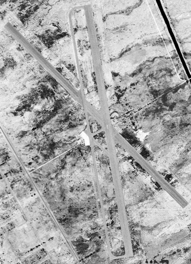
A 12/30/05 aerial view looking northwest shows the 2 large runways, parallel taxiway, and ramp which remain intact.
A 2006 aerial view taken from a remote-controlled aircraft by Jeff Moore, looking northeast at the Manazar runways.
The Manzanar Airfield was reused for a very unusual purpose –
filming of a elaborate “see saw” Toyota truck commercial
which aired during the 2007 Superbowl (airfield identified by John Szalay).
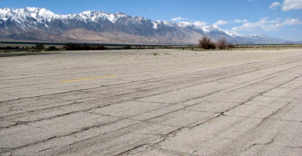
A 3/26/08 view looking across the Manazar runways toward the beautiful snow-capped mountains.
An October 2014 aerial view by Dustin Mosher looking south at the Manzanar Airport.
Dustin observed, “The 'good' runway is starting to show growth of small weeds through the cracks,
but none of the thick sagebrush that plagues the crosswind runway. The good runway is very land-able.”
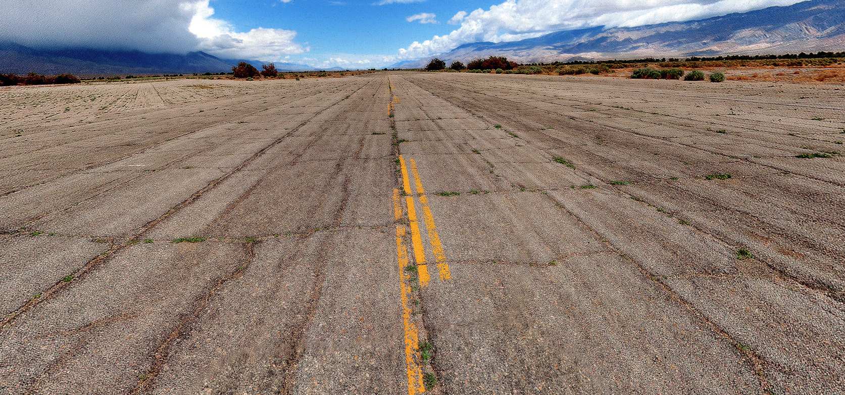
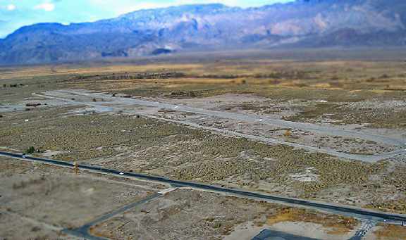
A 2014 photo looking northwest along the former Manzanar Airport northwest/southeast runway.
Pierce Stewart reported in 2015, “Even though it’s closed, every time I fly up the Owens Valley, I land at the long closed Manzanar Airport.
It’s still in great shape & could easily be brought back into service.”
Lane Leonard repored in 2018, “I drove by there on my way to and from Mammoth & it looked like the runway is now in disrepair.
Only a glider trailer there.”
The Manzanar airfield site is bisected by Manzanar Reward Road (which passes right through the runway intersection).
The airfield is bordered on the west side by Route 395, and the Los Angeles Aqueduct on the east side.
The site of the relocation center is on the other side of Route 395.
____________________________________________________
Since this site was first put on the web in 1999, its popularity has grown tremendously.
If the total quantity of material on this site is to continue to grow,
it will require ever-increasing funding to pay its expenses.
Therefore, I request financial contributions from site visitors,
to help defray the increasing costs of the site
and ensure that it continues to be available & to grow.
What would you pay for a good aviation magazine, or a good aviation book?
Please consider a donation of an equivalent amount, at the least.
This site is not supported by commercial advertising –
it is purely supported by donations.
If you enjoy the site, and would like to make a financial contribution,
you
may use a credit card via
![]() :
:
Please consider checking the box to make a monthly donatation.
For a mailing address to send a check, please contact me at: paulandterryfreeman@gmail.com
If you enjoy this web site, please support it with a financial contribution.
This site covers airfields in all 50 states.