
Abandoned & Little-Known Airfields:
California: El Centro area
© 2002, © 2024 by Paul Freeman. Revised 8/15/24.
This site covers airfields in all 50 states: Click here for the site's main menu.
For the 8th year, the CA pages of this website are sponsored by the California Pilots Association:
____________________________________________________
Please consider a financial contribution to support the continued growth & operation of this site.
Holtville NAAS / Holtville Airport (revised 3/2/21) - Holtville NALF / Sand Hill NOLF (revised 3/26/17)
Imperial Gables Landing Field (revised 11/30/14) - North Coyote Wells NOLF (revised 3/26/22) - Salton Sea NAAS (revised 8/15/24)
South Coyote Wells NOLF (revised 10/20/19) - Westmorland NOLF (revised 1/30/22)
____________________________________________________
Imperial Gables Landing Field, Imperial Gables, CA
33.124, -114.887 (Northwest of Yuma, AZ)
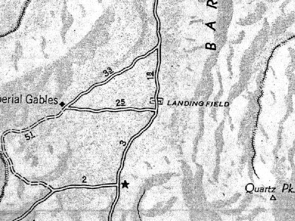
Imperial Galbes "Landing Field", as depicted on a "pre-WW2" AAA road map (courtesy of Francis Blake).
Photo of the airfield while in use has not been located.
Hardly anything is known about this former airfield,
located in an extremely desolate part of the Southern California desert, just northwest of Yuma, AZ.
The only depiction of the field which has been located is on a "pre-WW2" AAA road map (courtesy of Francis Blake),
which labeled the site simply as "Landing Field".
The map appeared to show the airfield area as extending east/west across the road.
Not much else is known about this airfield, including its actual name, or dates of construction & abandonment.
No airfields were listed at the location in airport directories from 1937, 1944, or 1945, nor on the 1934-46 San Diego Sectional Charts.
Francis Blake reported in 2003, that "A friend, a retired Highway Patrol officer who has been in Blythe since 1965,
asked an older, retired Fish & Game officer about Imperial Gables.
The latter said Imperial Gables was at some time a brothel & moonshiners' place of business.
I have 4 old Auto Club maps of Imperial County (1931-82)
and noticed that the 1951 map identifies the place as the 'Gold Diggers Club', so I'm guessing the airfield was for VIP visits.
Prior to WW2, Imperial Gables was on the main road between Glamis & Blythe,
but the establishment of the Chocolate Mountain Gunnery Range during WW2
included that portion of the road between Glamis & Imperial Gables,
so the road had to be rerouted to its current position (and smack through the Northeast/Southwest runway)."
Nothing at all is depicted at the site on USGS topo maps from 1953, 1969, 1980, or 1992.
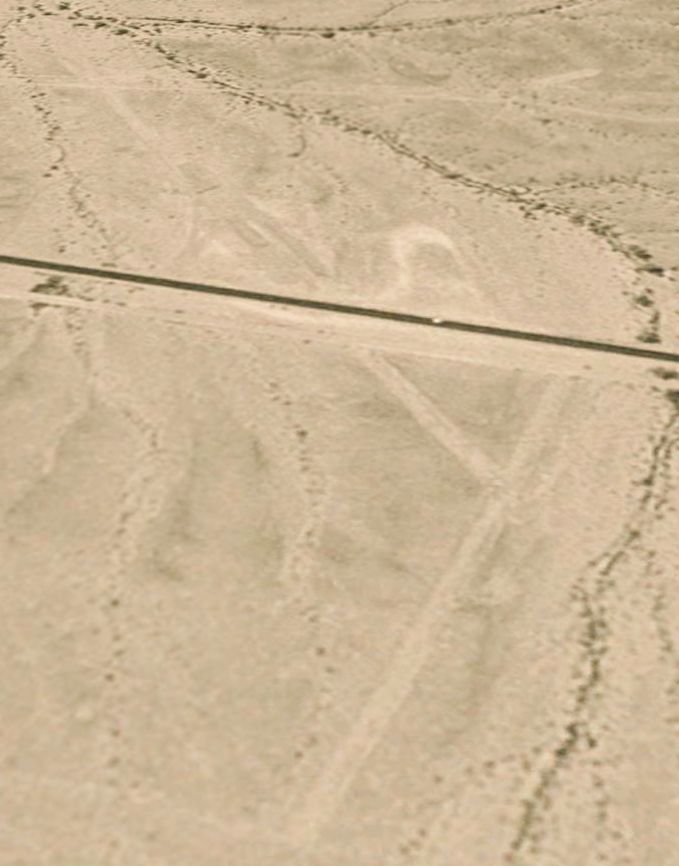
The earliest photo which has been located of the site of the Imperial Gables airfield was a 1981 aerial view.
It depicted the outlines of 2 runways: a northeast/southwest runway which crosses the road,
and a shorter northwest/southeast strip on the west side of the road.
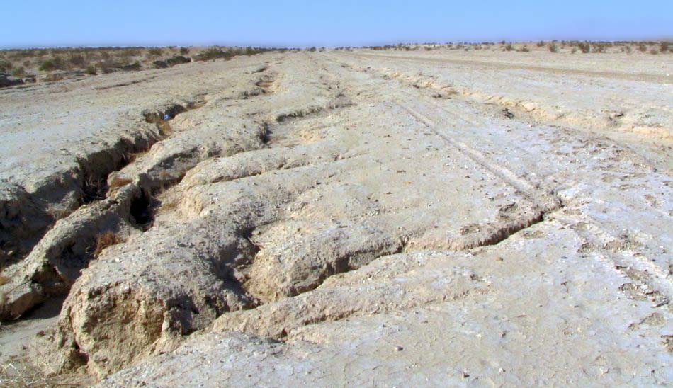
In a 1996 USGS aerial view looking east, the remains of the Imperial Gables airfield were still recognizable.
The outlines of 2 runways were still apparent - a 1,400' northeast/southwest runway which crosses the road,
and a shorter northwest/southeast strip on the west side of the road.
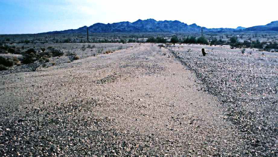
A 2003 photo by Francis Blake (enhanced by Bill Grasha), looking east along the abandoned east/west runway at Imperial Gables.
Francis Blake reported that "the runways haven't been used for some time.
A portion of [the southwest/northeast] runway is being used by the highway maintenance department for gravel storage."
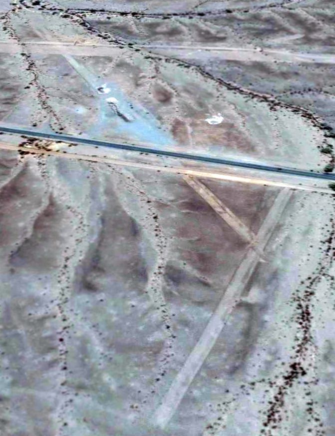
A 2014 aerial view looking east shows the remains of 2 Imperial Gables runways to remain quite recognizable.
Duncan Woods reported in 2015, “I went right by the site of Imperial Gables Airfield & stopped & looked around.
Kind of difficult to see the old runways from ground level, but they're still there.”
The site of the Imperial Gables Landing Strip is located along Route 78, 14 miles northeast of Glamis, CA.
Thanks to Francis Blake for pointing out this airfield.
____________________________________________________
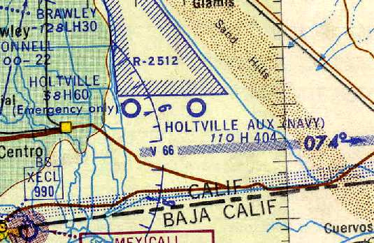
North Coyote Wells Naval Outlying Landing Field, Coyote Wells, CA
32.93, -115.88 (East of San Diego, CA)
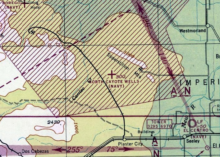
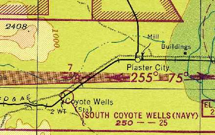
The North Coyote Wells airfield (misspelled as “Cayote”), as depicted on the March 1944 San Diego Sectional Chart (courtesy of Ron Plante).
Photo of the airfield while in use has not been located.
Apparently this military auxiliary airfield did not exist before WW2,
as it was not depicted on the 6/30/38 “Map of Leased Auxiliary Landing Fields,
Naval Operating Base San Diego” (courtesy of Brian Rehwinkel).
According to Brian Rehwinkel, “Coyote Well North Emergency Field was built to support the Coyote Wells Bomb Target (Bomb Target # 77).”
North Coyote Wells NOLF was used during WW2
as one of at least 12 auxiliary airfields attached to San Diego NAS (North Island).
It was also known as Coyote Wells #2 NOLF.
North Coyote Wells NOLF was not yet depicted at all on the August 1943 San Diego Sectional Chart (courtesy of Ron Plante)
nor on the 1944 USGS topo map.
The earliest depiction which has been located of North Coyote Wells NOLF
was on the March 1944 San Diego Sectional Chart (courtesy of Ron Plante).
It depicted "North Coyote Wells (Navy)" as an auxiliary airfield.
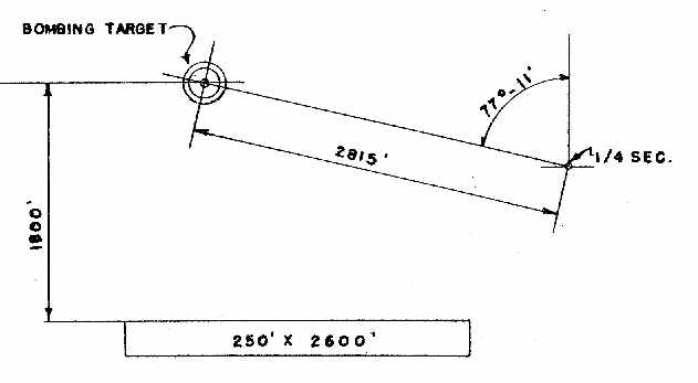
“Coyote Wells (North) Field”, as depicted on the May 1944 “Directory of NAS San Diego Naval Auxiliary Air Stations,
Outlying Fields & Emergency Landing Fields” (courtesy of Brian Rehwinkel).
It depicted “Coyote Wells (North)” as having a single sandy silt 2,600' Runway 9/27,
with a circular bombing target to the north of the runway.
No buildings were depicted at the field, which was said to have no facilities.
The March 1945 San Diego Sectional Chart (courtesy of Chris Kennedy)
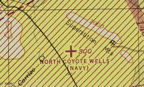
depicted "North Coyote Wells (Navy)" as an auxiliary airfield.
The 1945 AAF Airfield Directory (courtesy of Scott Murdock) described “Salton Sea Field Auxiliary (07881 North Coyote Wells Outlying Field)”
as a rectangular property containing a single 2,600' east/west sandy silt runway.
The field was not said to have any hangars.
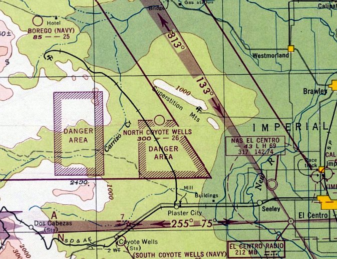
The last aeronautical chart depiction which has been located of North Coyote Wells NOLF was on the March 1948 San Diego Sectional Chart.
It depicted "North Coyote Wells" as having a 2,600' unpaved runway.
Note that it was no longer depicted as a Navy airfield, possibly indicating a brief period of reuse as a civilian airfield.
The North Coyote Wells airfield was evidently abandoned at some point in 1948,
as it was no longer depicted on the September 1948 San Diego Sectional Chart.
The North Coyote Wells airfield was not depicted on the 1956 USGS topo map.
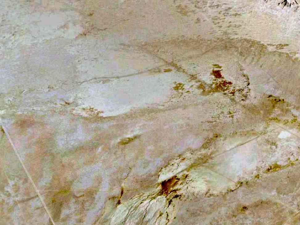
A 5/25/09 aerial view (enhanced by Bill Grasha) did not depict any trace of the former North Coyote Wells airfield.
____________________________________________________
Westmorland Naval Outlying Landing Field, Westmorland, CA
32.928, -115.713 (East of San Diego, CA)
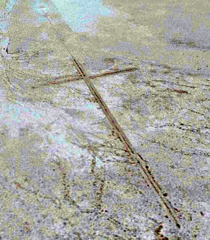
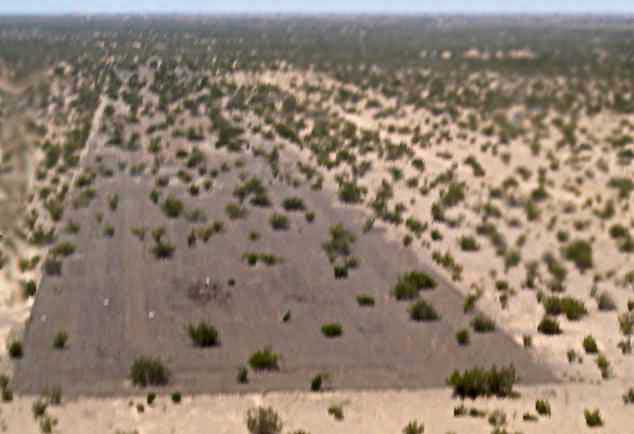
A 1996 USGS aerial view looking northwest at the Westmorland airfield site.
The actual name of this airfield is unknown.
No airfield at this location was listed in the 1945 AAF Airfield Directory (courtesy of Scott Murdock),
depicted on a 1953 aerial photo, the 1957 USGS topo map, more recent topo maps,
or on aeronautical charts from the 1940s through the present day.
As depicted on the above 1996 aerial photo, the Westmorland airfield appears to consist of the remains of a 4,000' southeast/northwest runway,
along with a much shorter perpendicular northeast/southwest runway.
The remains of the 2 presumed Westmorland runways remained basically unchanged in a 2015 aerial view looking north.
The site of the Westmorland airfield is located north of the intersection of Imler Road & Huff Road, 8 miles north-northwest of El Centro NAF.
Thanks to Chris Kennedy for pointing out this airfield.
____________________________________________________
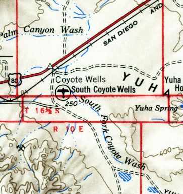
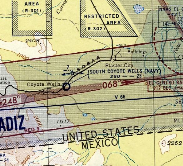
South Coyote Wells Naval Outlying Landing Field / South Coyote Wells Airport, Coyote Wells, CA
32.74, -115.96 (East of San Diego, CA)
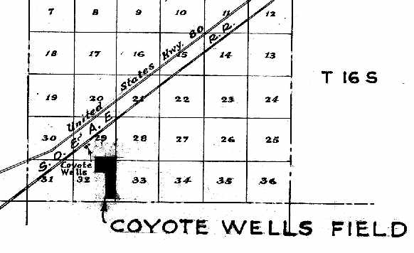
“Coyote Wells Field”, as depicted on the 6/30/38 “Map of Leased Auxiliary Landing Fields, Naval Operating Base San Diego”
(courtesy of Brian Rehwinkel).
The date of establishment of the South Coyote Wells airfield has not been determined.
The earliest depiction of the field which has been located
was the 6/30/38 “Map of Leased Auxiliary Landing Fields, Naval Operating Base San Diego” (courtesy of Brian Rehwinkel).
It depicted “Coyote Wells Field” as being located to the southeast of the town of Coyote Wells.
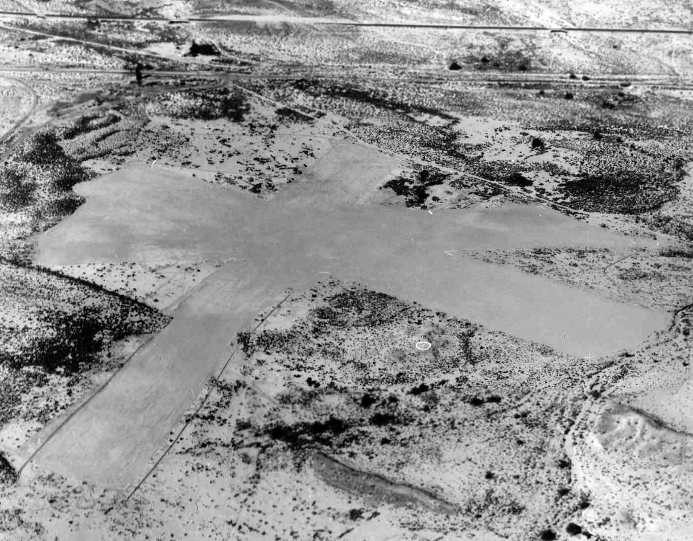
The earliest photo which has been located of South Coyote Wells Airfield was a 12/9/38 U.S. Navy aerial view looking north (from the National Archives, courtesy of Brian Rehwinkel).
It showed unpaved runways which had been graded very smoothly in contrast to the surrounding desert,
with a white airfield circle marking to the south of the runway intersection.
There were no buildings on the airfield.
According to Brian Rehwinkel, “Based on information from Navy & General Services Administration memos,
Coyote Wells (South) Emergency Field was comprised of 215 acres.
The field had been leased by the Navy before 1941
and the 215 acres was purchased by the Navy for $5,500.
I don’t think this field was used much (as with the other Imperial Valley emergency fields).
One Navy document described the runways as 'soft when dry; marshy when wet.'
The Navy did consider paving the runways at this field, but decided against investing any more money into the facility.
Interestingly enough, this field was the only emergency field in the area that was not associated with a bomb target.
Since many of these bomb target were used for dive bombing practice,
the navy was concerned about the heat damage caused to plane engines while climbing quickly for dive bombing.
Their preference was to use fields closer to the coast.
The Navy description of Coyote Wells Field listed 127 degrees as the maximum summer temperature…”
During WW2, the South Coyote Wells Naval Outlying Landing Field
was one of at least 12 auxiliary airfields attached to San Diego NAS (North Island).
It was also known as Coyote Wells #1 NOLF.
Strangely, no airfield at this location was depicted on the 1937-42 San Diego Sectional Charts
nor on the 1943 USGS topo map.
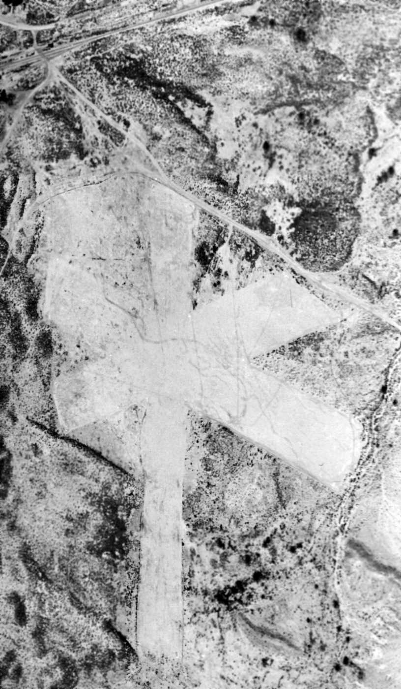
The last photo which has been located of South Coyote Wells Airfield was a 3/23/44 U.S. Navy aerial view looking (from the National Archives, courtesy of Brian Rehwinkel).
The unpaved runways were much less distinct compared to the 1938 aerial view,
and the airfield circle marking to the south of the runway intersection was also still recognizable but deteriorated.
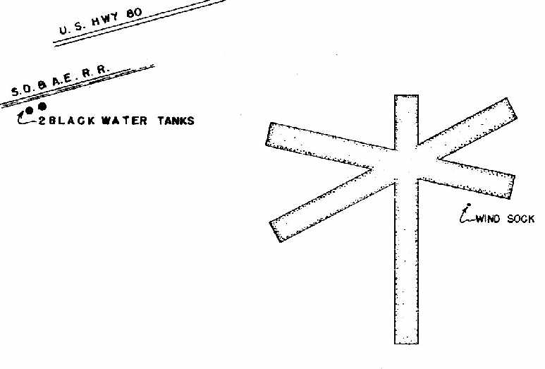
A May 1944 “Directory of NAS San Diego Naval Auxiliary Air Stations, Outlying Fields & Emergency Landing Fields” (courtesy of Brian Rehwinkel)
depicted “Coyote Wells (South) Field” as having three 2,500' sandy silt runways, oriented 18/36, 4/22, and 9/27.
There were no buildings depicted at the field, only a single windsock to the southeast of the runway intersection.
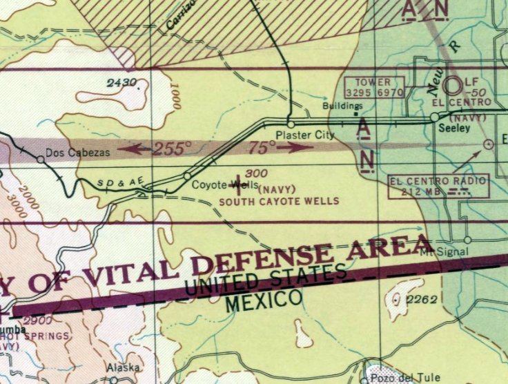
The March 1944 San Diego Sectional Aeronautical Chart depicted "(Navy) South Coyote Wells"
as an auxiliary airfield located 3 miles east of the town of Coyote Wells.
Note that this was a different location compared to other depictions (which showed the airfield adjacent to the town of Coyote Wells), and may have been erroneous.
The 1948 San Diego Sectional Chart (courtesy of Chris Kennedy) depicted "South Coyote Wells (Navy)"
directly adjacent to the town of Coyote Wells.
"South Coyote Wells (Navy)" was depicted on the March 1951 San Diego USAF Sectional Chart (according to Chris Kennedy),
but the Aerodromes table described the field as "Closed".
South Coyote Wells was depicted as a civilian airport on the 1954 USGS topo map.
South Coyote Wells NOLF was still depicted (adjacent to the town)
on the March 1955 San Diego Sectional Aeronautical Chart (courtesy of John Voss).
The Aerodromes table on the chart described the field as having three bare runways (the longest being 2,275'),
and included the remark, "Caution: Soft & rough."
Brian Rehwinkel reported, “According to an August 1955 memo,
the Navy was preparing to report Coyote Wells (South) as excess to the needs of the Navy
(along with other Emergency Landing Fields - Clark’s Dry Lake, Ocotillo Dry Lake, Borego Hotel).
The landing field was apparently disposed of sometime after 1955.”
South Coyote Wells NOLF was no longer depicted on the September 1955 San Diego Sectional Aeronautical Chart.
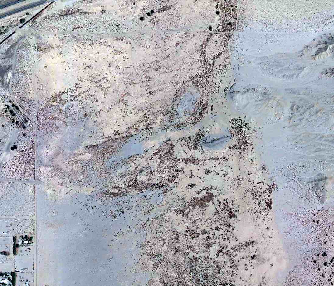
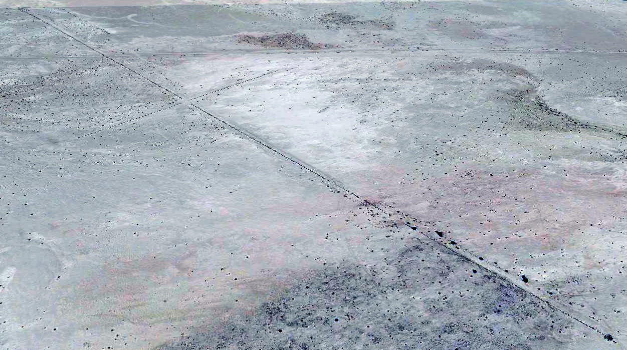
A 2014 aerial view does not appear to show any recognizable trace of the South Coyote Wells Airfield.
However, Brian Rehwinkel observed, “If you look very closely, you can still make out some of the 'white chalk' boundary markers that indicated the ends of the runways.
The feature that really firms up the location is the railroad 'wye' just to the west of the field location.
You can still see the outline of where the tracks were located... and you can see the functioning 'wye' in the 1944 aerial.”
The site of South Coyote Wells NOLF is located south of the intersection of Interstate 8 & Moltar Road.
____________________________________________________
Holtville Naval Auxiliary Air Station / Holtville Airport, Holtville, CA
32.84, -115.27 (East of El Centro, CA)
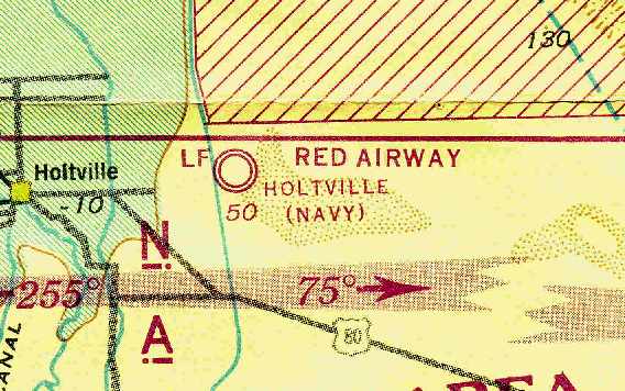
“Holtville (Navy)”, as depicted on the August 1943 San Diego Sectional Chart (courtesy of Chris Kennedy).
The Navy purchased 1,397 acres in 1942 to build an auxiliary airfield to support Navy flight training.
Holtville was commissioned in 1943, under the command of Naval Air Center San Diego.
The base initially had two 4,500' concrete runways.
The earliest depiction of the Holtville airfield which has been located
was on the August 1943 San Diego Sectional Chart (courtesy of Chris Kennedy).
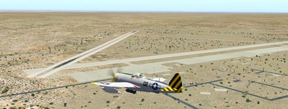
A flight simulator scenery depiction looking east at a Republic P-47 Thunderbolt overfltying NAAS Holtville.
Holtville was used by the Navy to train pilots in skip bombing, night flying, and air-to-ground rocket firing.
Aircraft operated at Holtville included F6F Hellcat & F4U Corsair single-engine fighters.
The weather at Holtville was both a blessing & a curse: it boasted 360 days of VFR per year,
but also had summertime temperatures routinely over 100 degrees.
An atlas stated that Holtville & a spot in the Sahara desert were the hottest places on earth.
Holtville had one outlying field, Sand Hill NOLF,
located 8 miles to the east of the base along an unpaved road through the desert.
An extensive construction program in 1944 significantly expanded Holtville's facilities.
The 2 runways were extended to their ultimate length of 6,000'.
Two ground training buildings were constructed that housed Link Trainers & a Gunairstructor.
Overall, the base's capacity was doubled, to support six squadrons.
It had a total complement of 2,980 officers & enlisted.
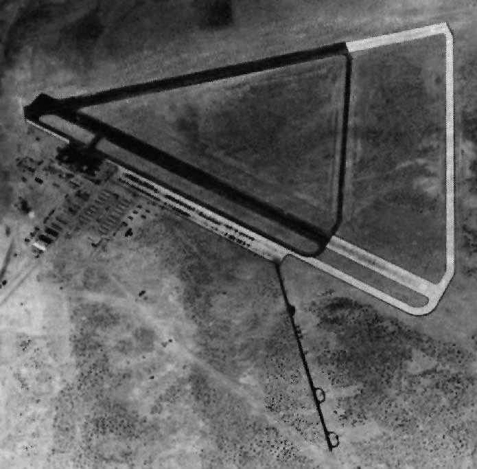
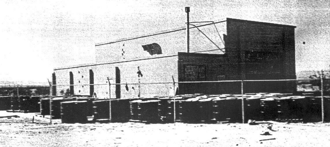
A 1944 aerial view looking north at the Holtville airfield (National Archives photo, enhanced by Bill Grasha).
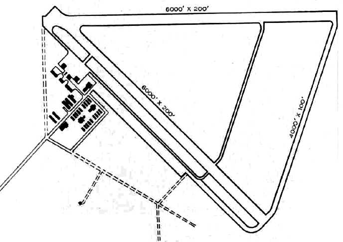
The 1945 AAF Airfield Directory (courtesy of Scott Murdock) described Holtville NAAS
as a 1,400' acre irregularly-shaped field containing 3 concrete runways, the longest being the 6,000' northwest/southeast & east/west strips.
The field was said to have 2 wooden 80' x 32' nose hangars.
Holtville was was described as being owned by the U.S. Government & operated by the Navy.
The Army Corps of Engineers reported that following the end of WW2,
Holtville was used for a few months to store 111 "PV-2 Privateers" (a contradictory designation).
The station then went into caretaker status in 1946.
A June 1946 Department of Commerce Airman's Guide (according to Chris Kennedy)
redesignated “Holtville NAAS” to “Holtville Airport” as of 5/27/46.
Holtville was transferred to Imperial County for use as a county airport in 1947.
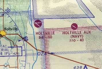
“Holtville” was depicted as a civilian airport
on the March 1951 San Diego Sectional Chart (courtesy of Chris Kennedy).
It was depicted as having a 6,200' hard surface runway.
However, Holtville may have been reactivated as a military airfield at some point between 1951-55,
as it was depicted once again as as a Navy airfield
on the 1955 San Diego Sectional Aeronautical Chart (courtesy of John Voss).
The Aerodromes table on the reverse side of the chart described Holtville
as having three concrete runways (the longest being 6,160'),
and included the remarks, "OLF to NAAS El Centro. Use caution, concrete paving faulting."
For some period after WW2, the airfield's buildings were reused as the Imperial Valley Sanitarium.
Chuck Hancock recalled, "I grew up in Imperial Valley
and remember many of the airfields because I saw them in use during WW2.
One airfield in particular is of note & that is the Holtville NAAS.
It was turned over to Imperial County as a Sanitarium.
It was an isolation sanitarium for TB patients."
Chuck continued, "In addition, I worked for a crop dusting company as a loader in high school & college (1951-55).
It was miserably hot - so was the rest of the area.
We used the airfield as a loading spot for our crop dusters which we flew out of Imperial.
There was no security, but we stored the dust outside on the ramps
(50 pound bags of sulphur & DDT, Toxaphene, and other poisonous stuff)
when we dusted fields in the area.
The hangers were abandoned, but usable. Some people stored their private planes in them.
There were no servicing facilities so we had to bring our own gas if it was a long day of dusting.
Flying Stearmans (converted PT-17s) out of Holtville was no problem since the runway was still in good shape,
but we usually used the ramp for takeoffs because a Stearman takes off in no distance at all.
I always look for the runways when I leave San Diego on a trip. Very obvious."
Harry Gordon recalled, “In May 1952, I flew a friend's single-seat Schweizer 1-19 glider at Holtville Airport, towed aloft from the runway behind my 1936 Dodge.
The airport was apparently unoccupied at the time & was identified as a Navy auxiliary field.
While we were there, one other airplane landed, a Luscombe Silvaire.
The occupants of the Luscombe were watching our glider flights & laughed when I overshot a landing & ran off the end of the runway (no damage).
I managed to survive 5 flights that day. My friend & I both had private pilot's licenses, but neither of us had any glider training.”
Will McCown recalled, “I can remember when I was a kid & the TB Sanitarium was there -
the Sanitarium was located in the main buildings of what had been a pretty substantial base.
But in addition there were numerous Quonset huts,
and these were occupied as well by perhaps a dozen families.
I had friends in school who lived in them.”
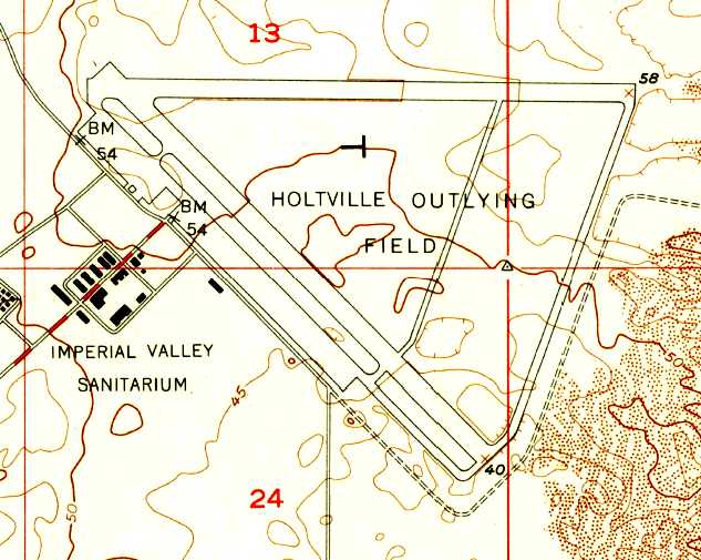
The 1957 USGS topo map described “Holtville Outlying Field” as having 3 paved runways, ramps, and buildings to the southwest.
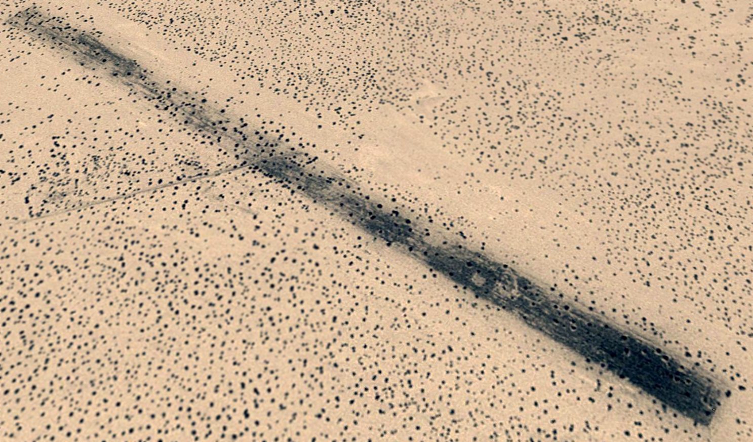
John Snapp recalled that one of Holtville's runways were used to stage drag races.
"The Holtville Drag Strip was operated by the Imperial Valley Timing Association.
The Holtville track was run from 1957-87.
It never ran in the summer because of the extreme heat.
It's biggest race was the annual Carrot Carnival Championship in February.
They used the [east/west] runway as evident by the black marks in the photo.
It only ran once a month.
It was NHRA sanctioned, although it did not have a guardrail that I am aware of.
A track guide lists it as being 5,250' in length & strip surface of concrete
that was most likely laid out in squares which would explain the somewhat rough surface."
Tom Wilson reported, “I am a private pilot & have also raced cars, and I've done both at Holtville NAAF.
I raced with the San Diego Region of the Sports Car Club of America (SCCA).
They raced every winter, consecutively, at the old airbase from approximately 1965-2000.
Up until the mid-1990s these races were quite large (I recall one race with over 200 participant autos).
Races were normally held in November, occassionally December, January, February, March,
and were refered to as The Winter Series, as most other car racing championships are held in a single calendar year.”
Tom continued, “Much work was required to hold races at Holtville
because the concrete blocks the runway/taxiway/ramps are built from (20' x 20')
get pushed together by seismic & thermal action, apparently.
This causes random blocks to crack & fold into a steeply ramped V.
These V's can reach 3' in height.
We would jack hammer them, remove the debris & pour new concrete to make a smooth transition.
Nevertheless, the racing surface was always rough, and much car damage resulted in the lighter formula cars.
Also, as there was no security at the field, all gear had to be locked up in an old semi-trailer.
This included timing equipment, signalling flags, a hardwire communication net that circled the entire race track,
small stands for corner works & other equipment.
Eventually participation fell to unsustainably low levels & SCCA racing was abandoned at Holtville.”
Tom continued, “Many other car groups have used the SCCA track.
These include the Porsche Club, Nissan Club & even simple groups of racers who gathered for a weekend of testing.”
Holtville was evidently relinquished by the military (again) at some point between 1955-66,
as "Holtville" was depicted as a civil airport on the 1966 San Diego Sectional Chart (courtesy of Chris Kennedy).
According to John Snapp, the use of Holtville's runways for auto racing ended in 1987.
He recalled, “They stopped racing at Holtville
because the surface became too deteriorated & the club that ran it could not afford to re-pave it.”
According to Michael Newman, “The Navy SEALs Leap Frogs (US Navy Parachute team)
used Holtville NAAS for practice jumps much of the late 1980s & early 1990s.
I do not know if they still do, but it was a great location at the time.
It was close enough to North Island NAS for single days training.
Only the ground crew that had to drive out from San Diego & back had a long day of it.”
USAFR SSgt. Dennis Wesley recalled, "Back in the late 1980s,
a military preservation society called 'The Combat Heritage Foundation'
supposedly leased the Holtville airport from Imperial County.
The foundation hosted at least 2 'airshows' out there.
I know because my father & I went to them.
I doubt you could really call them airshows because there was no real organized 'show'.
Mostly owners of old military planes would fly in.
They also put on a ground combat demonstration with people dressed as Americans & Germans.
A temporary 'control tower' was erected for the 2 shows I went to.
There were no big name performers at any of the events,
but the 'Condor Squadron' out of Van Nuys made an impressive showing both times,
as did the B-25 "Pacific Princess" owned by The Planes of Fame from Chino."
"The foundation planned on setting up a museum out there
complete with buildings re-erected as they were during the war.
But the group never really never got off the ground & soon went under.
As for work on the runways, prior to the shows,
a contractor from El Centro did in fact repair cracks on one of the runways,
because I used to receive the newsletter from the foundation that had a photo of the company doing the work."
Will McCown recalled, “I used the field numerous times between 1990-2001
due to it being conveniently close to my family's farm (which is about 2 miles northwest of the field).
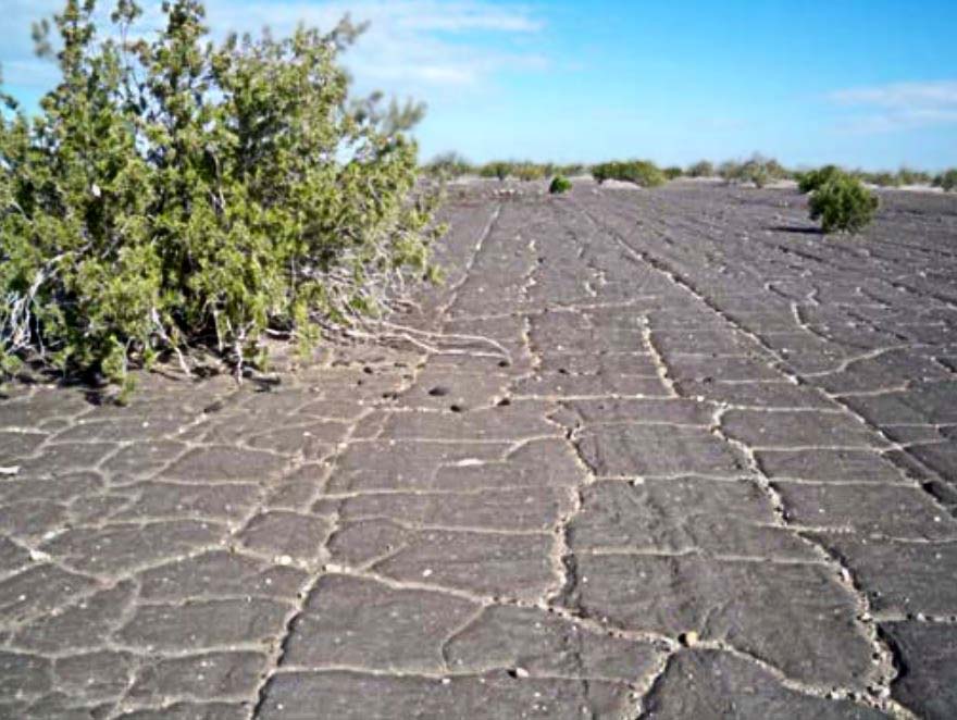
The runway was constructed from 8-10' square sections of concrete.
Leading to a rather different "tha-thunk tha-thunk tha-thunk" rhythm to your takeoff.
I have now doubt that being separate sections of concrete
is what has allowed the concrete to last 60+ years in the desert climate.
Temperatures are routinely over 110 & 120 isn't uncommon.
More than once when visiting I had to taxi around the track being used by folks racing their rally cars.
The runway pretty sound when I was using it.
The repairs that were mentioned were asphalt patches to some of the spalling corners.”
Tom Wilson reported, “In some of the aerial photos a southern section of the ramp is blue.
This is blue paint applied by a video crew which filmed a BMW auto commercial on the site in the late 1990s.”
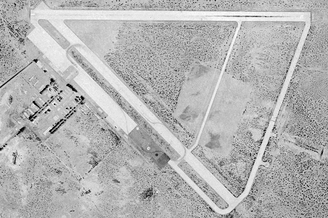
A 1996 USGS aerial view of Holtville Airport. Tom Wilson observed that this photo does depict “the turnouts on the outer connecting taxiway.
One of these is a simple knob-shaped turnout, another is a hardstand for bore sighting aircraft armament, as the built up butts are still visible south of that hardstand.”
Curiously, these turnouts were not yet present in the 1944 aerial photo.
Jim McAdory recalled, “I raced at Holtville in the late 1990s with the NASA racing organization.
One weekend we had a 'drivers school' with the lecture ime held in one of the remaining old buildings which appeared to be somewhat of a museum.
There
were a couple of display cases with small military items, insignia &
patches along with a few items that described the facility during
WWII.
Racing at Holtville was not a place to be if you had
loose fillings! It was a very rough surface.
In addition to the 'humps' there were also 'flappers' & 'clangers'. The flapper seemed to be some sort of flexible mat under some concrete sections.
When a hole got large enough a car moving over it at speed would cause the material to lift & a car following closely would hit the flapper.
I
did, more than once, and it sounded like the car had run into a wall
but it did little, if any damage.
The clangers were plough
disks that had the edges ground & then located at turns using
spikes to secure them.
It made a loud clanging noise when you ran over them & they were the source of more than one flat tire.
My last trip there was in March of 1999 for a single test day organized by the San Diego chapter of NASA.
I had a thermometer in my car that had a limit of 140 & it was pegged there all day long.
I drank water & Gatorade all day, never went to the bathroom once & upon my return home I found I had lost 10 pounds!”
According to USAFR SSgt. Dennis Wesley, "As of 2001, the Porsche Club of San Diego used the field for auto races."
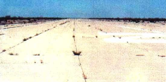
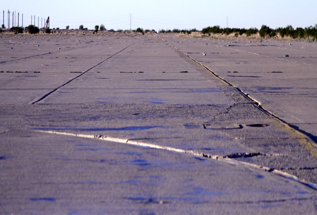
A view south along Holtville's primary runway, 2001.
Will McCown recalled, “On my last visit in 2001 I was chatting with the management
(new fellow who took over from 'The Combat Heritage Foundation').
They said that they had been paid a visit by the California State Aeronautical Board,
and that the runway (8/26 the only runway still listed as a runway)
had to have the vegetation cleared for 30' (or some number like that) beyond the edges of the concrete
(rather silly as the concrete is 150' wide).
I suggested that they declare the runway as 30' wide & the rest of the concrete be the boundary - and that had been thought of.
They would have to paint the appropriate yellow line at the edge, just as expensive as clearing the creosote bushes).”
The Army Corps of Engineers reported in 2001, "The field gets very little use & is not maintained by the County."
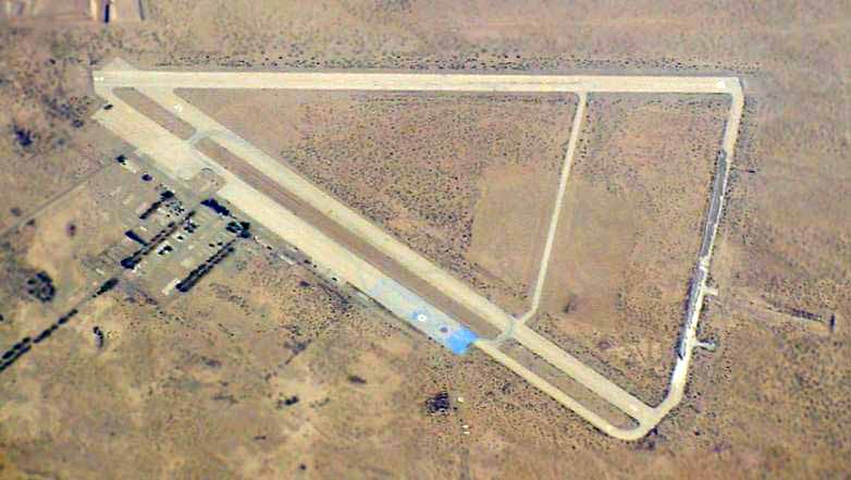
A 2002 aerial photo of Holtville by Suresh Atapattu, used with permission.
Tom Wilson reported, “The piles of debris on the outermost connecting taxiway are seaweed.
Some fellow thought he was going to corner the market on kitty litter with his seaweed product.
I don't know if he ever made any kitty litter, but he sure left huge piles of seaweed.”
As of 2002, it is still listed in the Airport Facility Directory as an active civil airport, but Holtville Airport is all but abandoned.
Both of the runways still exist, as well as the taxiways & the large concrete ramp.
The only runway which is still maintained as an active runway is 8/26,
but it is described in the Airport Facility Directory as
"in poor condition, pavement cracked with vegetation growth & spalling."
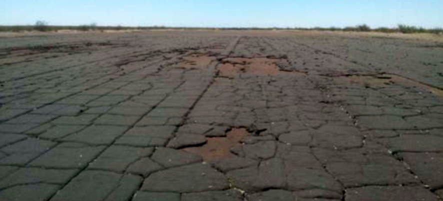
Only the foundations remain of most of the original military buildings.
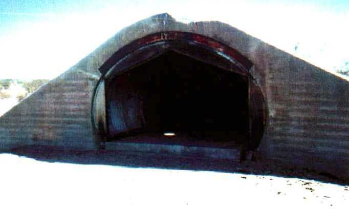
Francis Blake reported in 2003 that "the ammo bunkers at Holtville have been mostly demolished;
only the concrete ends are still standing."
Due to the field's proximity to Yuma MCAS & El Centro NAF, it is apparently still used for infrequent military aircraft training,
as the Airport Facility Directory includes the notes
"Be alert frequent military training activity during daylight hours & dark; includes tactical aircraft, helicopters & parachuting.
No vertical takeoffs or landings permitted at airport AV-8 Harrier."
The British Army parachute team has also been reported to have used Holtville for training.
The primary remaining use of the airfield is to host occasional auto races on its runways.
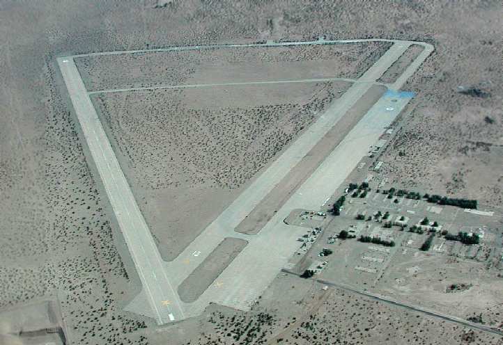
A 2003 aerial photo of Holtville by Bob Jones.
Bob Jones flew to Holtville in 2003, and observed that closed-runway "X" symbols have been placed on both runways.
"The pilot's guide showed it as open, but the locals say that it has been closed for years."
A representative from Imperial County said that the State had ordered Holtville closed until specific repairs were made.
Furthermore, Imperial County was seeking grant funds to make the repairs,
and until that happens, the Holtville Airport will supposedly remain closed.
Will McCown reported in 2005, “The airport is currently listed as active, but the runway is NOTAM'd closed.
I would not expect this status to change unless the military decides it wants to start using it for training again
and is willing to foot the bill to make it legal again.”
Will McCown observed in 2005 of the airfield's buildings once formerly reused as a Sanitarium,
“Only the foundations & street pattern remain of all of this.”
Woodrow Anselen reported in 2008, “Arriving over Holtville, I circled the field twice.
Both the east/west & north/south runways are marked with yellow Xs,
so I have to assume that they are closed (I asked the FSS man before the flight about the field status,
and he gave me the odd answer that the closure was a political issue, and he could not comment on that).
The 3rd runway is in very bad shape.
It appears to have been deliberately dug up, and there is a lot of debris on it.
The east/west runway also has some rather sizeable potholes, although these could have been avoided,
but I opted for northerly landing on the remaining runway as the wind favored a northerly landing anyways.
Although some fairly substantial weeds can be seen growing from the cracks in the all concrete runway,
a landing was easily made & all obstructions were avoided.”
Woodrow continued, “I exited the aircraft into a furnace-like heat.
Adjacent on the east side of this runway is an RV park.
Pretty weird place for an RV park! What is the attraction? Maybe people live there permanently?
The ammunition bunkers seen in previously taken pictures are still there, although somewhat removed from the field.
As I stupidly did not bring suitable hiking boots I was reluctant to march through
a large field of tall weeds in order to reach them: Rattlesnake country!
Even so, I was able to see that the bunkers are much dilapidated, and none that I saw was entirely intact.
The fore & aft walls on several still stood, but the adjoining walls & roof were gone.”
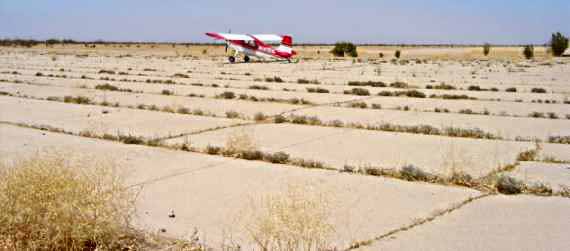
A 2008 photo by Woodrow Anselen (enhanced by Bill Grasha) of Woodrow's 1998 American Champion Scout on the runway at Holtville.
Woodrow observed, “Bloody hot! +42 C degrees!”
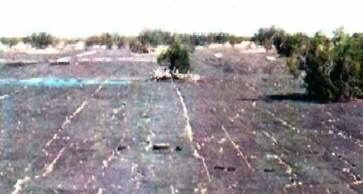
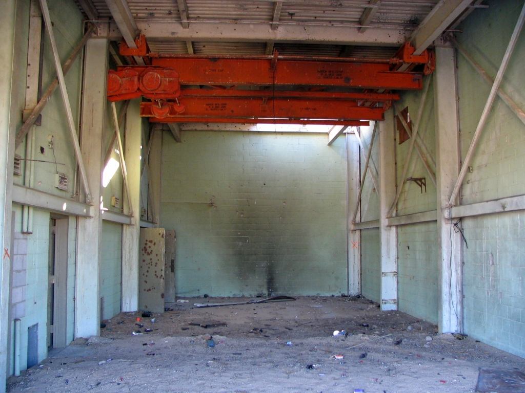
An 11/25/14 photo by Jim Jordan of the Holtville ramp.
Jim reported, “What was very interesting about the Holtville NAAS was how busy it was with military operations.
There was some British paratrouper training (my guess is high altitude jump low altitude opening) and those guys were pretty much unmarked.
They took off for lunch & an Osprey [V-22] moved in for some touch & goes.
I talked to the guy from the Osprey crew & told him I was expecting a quiet day at Holtville. He said that did not happen very often!
So apparently the military uses it quite a bit right now, but nothing was marked/signed/etc.”
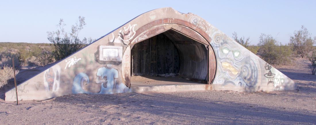
An 11/25/14 photo by Jim Jordan of a Holtville ammunition bunker.
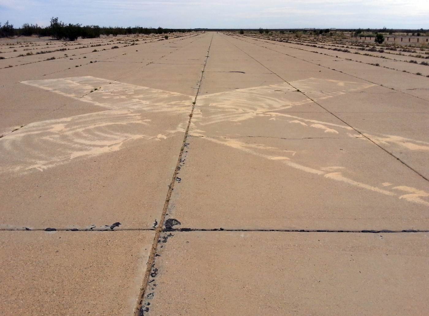
A 1/25/15 photo by Andrew Puyot Bañuelos looking along Holtville's northwest/southeast runway, showing the closed-runway “X” symbol.
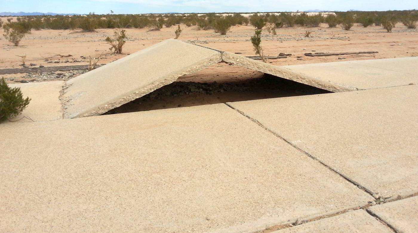
A 1/25/15 photo by Andrew Puyot Bañuelos of one of several concrete slabs of Holtville's northwest/southeast runway which have inexplicably been raised off the ground.
As to a cause, Andrew surmised, “There is little to no seismic activity out there. But there is geothermal activity in the area. Perhaps that has something to do with the movement.”
A 1/25/15 photo by Andrew Puyot Bañuelos of the piles of presumed “seaweed” which cover Holtville's east/west taxiway.
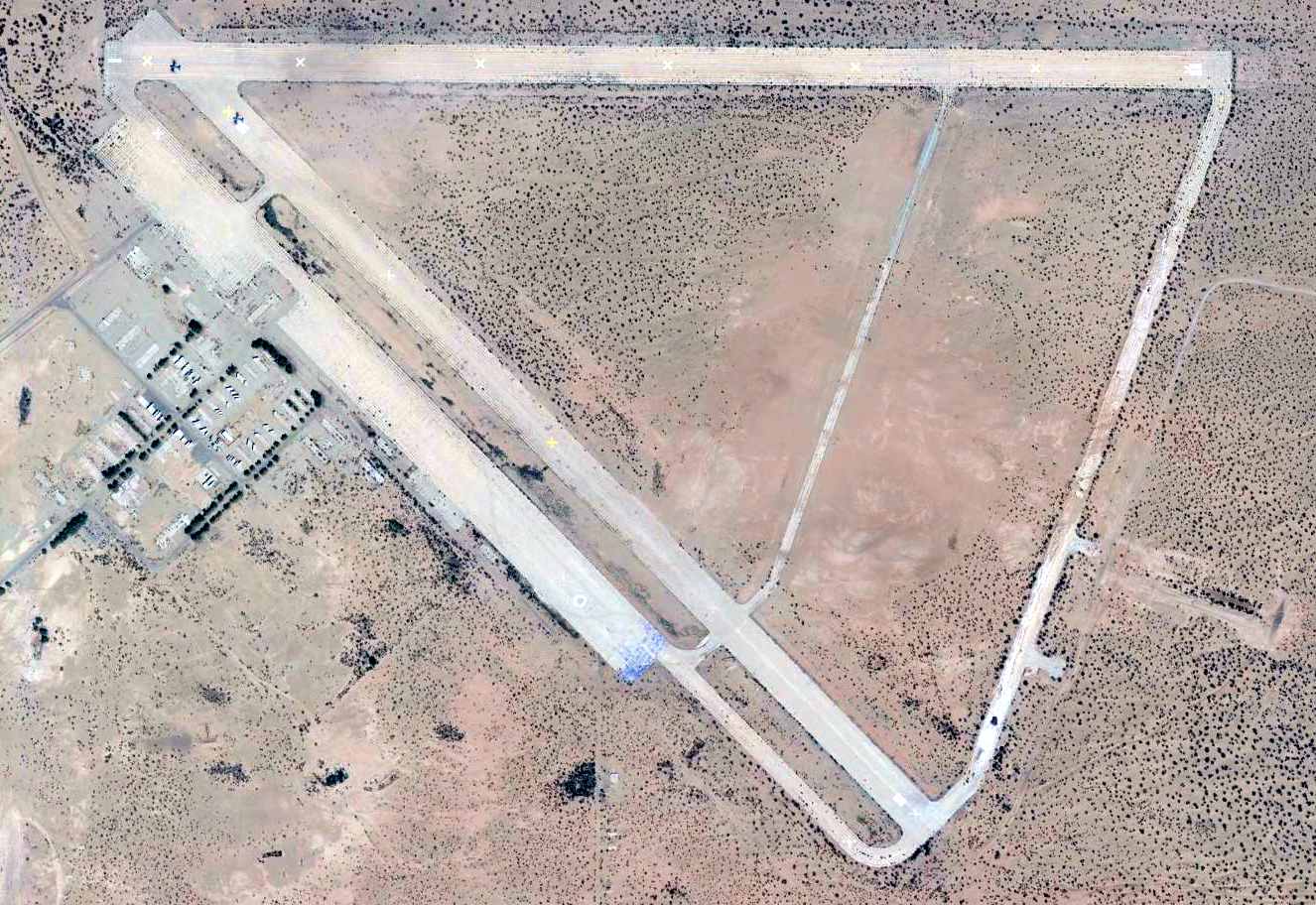
A 2015 aerial view of Holtville Airport, intact though deteriorated.
Both sets of runways were marked with closed-runway “X” symbols.
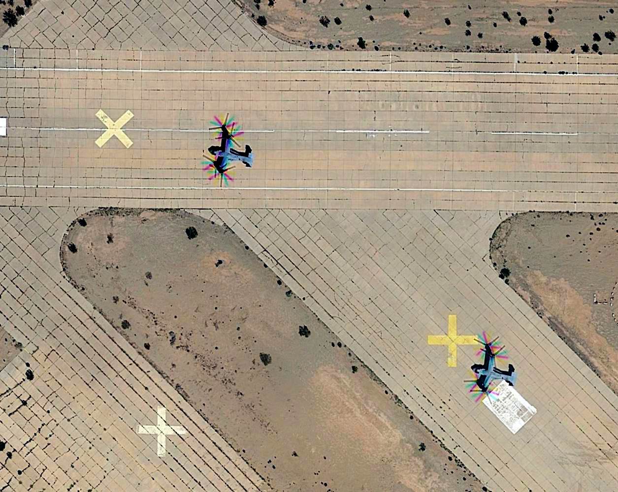
A closeup from the 2015 aerial view of Holtville Airport, showing 2 USMC Bell-Boeing MV-22B Osprey tilt-rotors operating on the northwest end of the runways.
The 2017 Sectional Chart shows Holtville was still charted & listed with the FAA as an active airport,
even though both of its runways have been marked with closed-runway “X” symbols for several years.
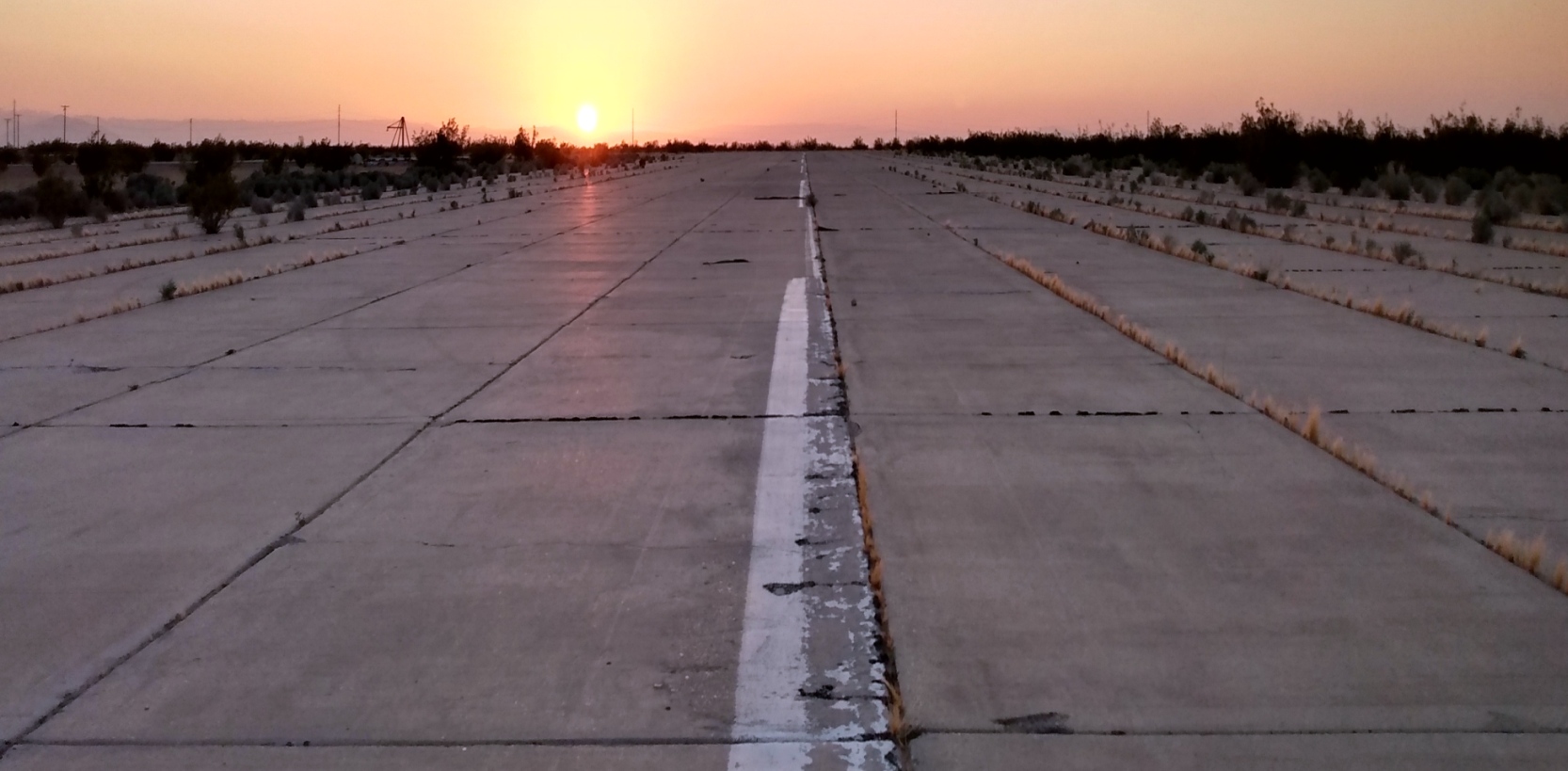
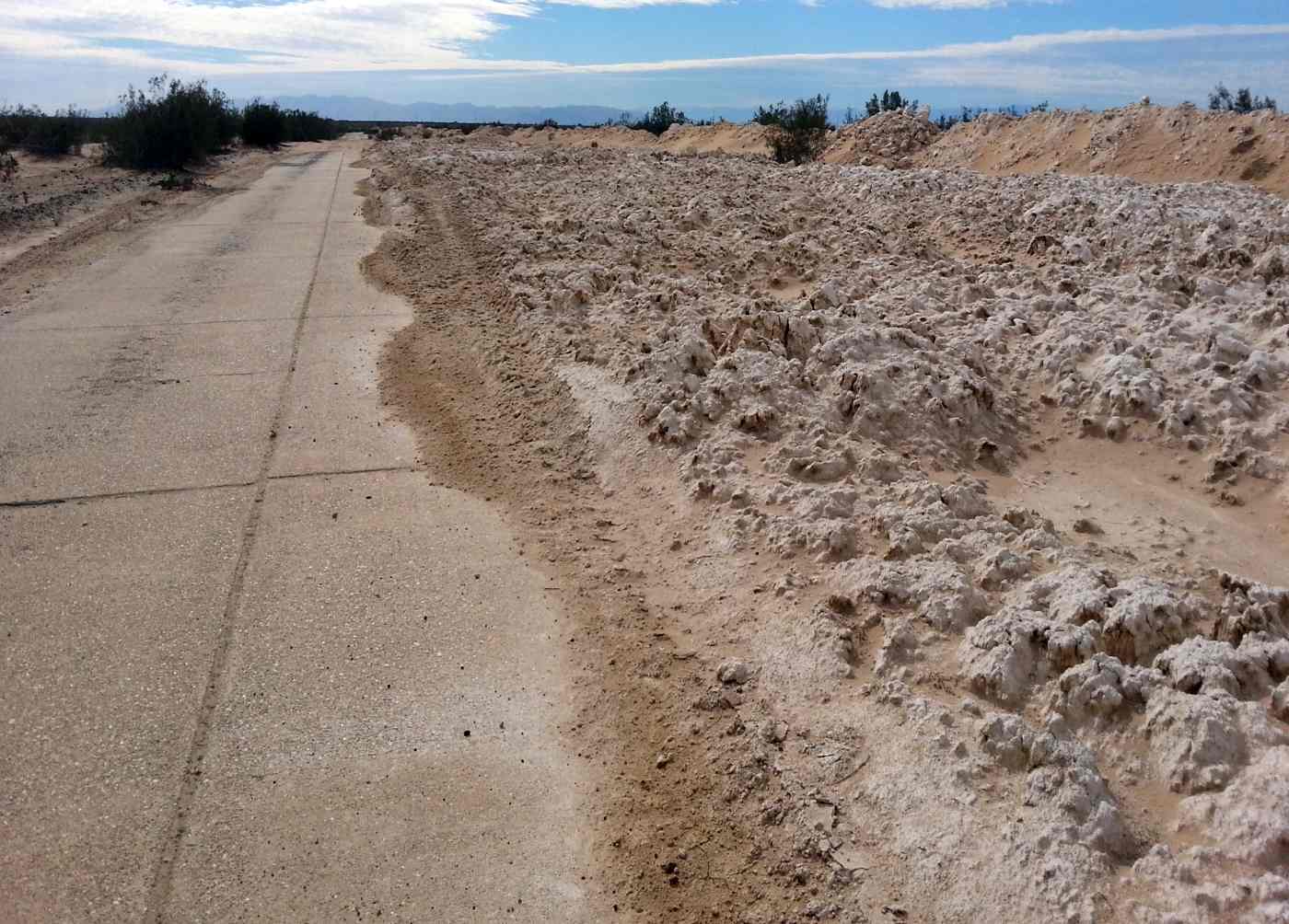
A 2/27/21 photo by Aris Lazerson of a Holtville runway.
Aris reported, “We camped overnight in the windsock circle.
Holtville as of this point shows evidence of regular use both by off-roaders, hobby shooters, arsonists (several burned-out RVs, vans, and trailers are on site), and the US Navy for both helicopter training & machine gun blank firing.
I found thousands of expended 5.56mm & 7.62x51 blank shells, M18 smoke grenade rings & fuzes.
Some areas of the east/west runway & north/south taxiway show signs of regular vegetation clearing.”
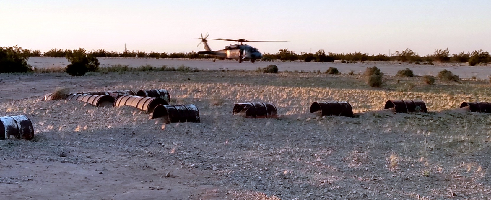
A 2/27/21 photo by Aris Lazerson of a Navy Sikorsky MH-60S Knighthawk taxiing at Holtville.
Aris reported, “I watched a pair of MH-60Ss practice hovering & spot landing for almost 5 hours.”
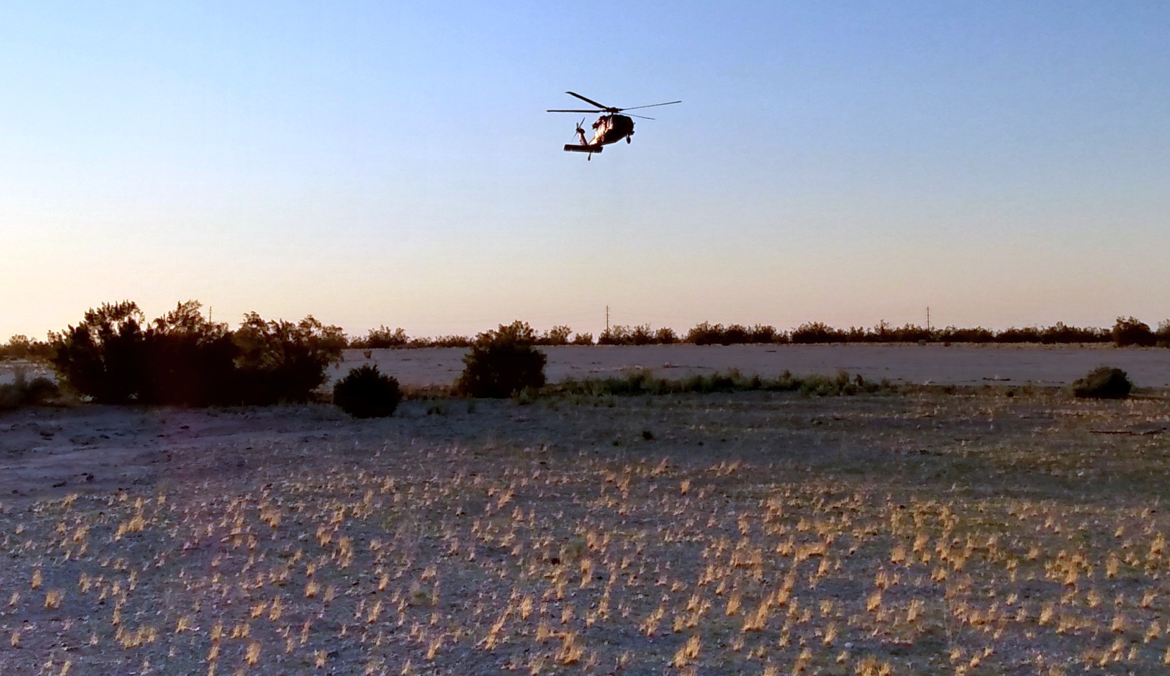
A 2/27/21 photo by Aris Lazerson of a Navy Sikorsky MH-60S Knighthawk in flight over Holtville.
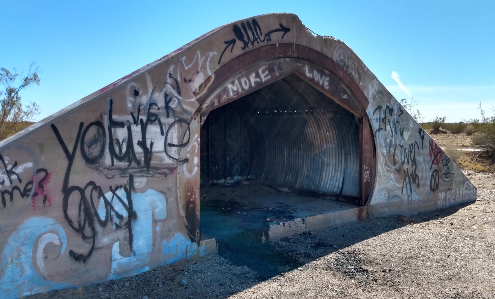
A 2/27/21 photo by Aris Lazerson of a Holtville ammunition bunker.
Andy Bushnell reported in 2022, “Holtville... We use it to launch high-power rockets now.”
Thanks to Jeffery Sternberg for pointing out this airfield.
____________________________________________________
Holtville Naval Auxiliary Landing Field / Sand Hill Naval Auxiliary Landing Field,
Sand Hill, CA
32.832, -115.152 (East of El Centro, CA)
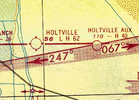
"Holtville Aux", as depicted on the March 1951 San Diego Sectional Chart (courtesy of Chris Kennedy).
Photo of the airfield while in use has not been located.
No airfield at this location was depicted on the 1943 San Diego Sectional Chart (according to Chris Kennedy).
According to Brian Rehwinkel, “In May 1944, the Navy received permission from the US Secretary of Interior
to use public land to build an airstrip in connection with Naval Auxiliary Air Station Holtville.
Approximately 110 acres was withdrawn from public land use for the 4,000’ x 200’ asphalt landing strip
(I don’t think this doesn’t include the approximately 7 miles road from the main base to the OLF).
This airfield, along with other similar airfields in Southern California – Sweetwater Dam OLF & Ramona OLF - was to be used for Field Carrier Landing Practice (FCLP).
I do not know exactly when the field was completed, but an 8/29/44 memo from the Bureau of Aeronautics to the Commandant of the 11th Naval District
refers to the landing strips as 'now under construction', so I am assuming the airfield opened in late summer or early fall 1944.
Another Navy document says the construction of the field totaled $104,857.
It is noteworthy that none of the documents I saw referred to the airfield as anything other than a 'Carrier Landing Strip' or a 'Carrier Landing Training Field'.
For a paved airfield, this really seems to fit the very definition of 'little-known' field.”
Although aviation charts depicted this field as “Holtville (Aux)”,
it was also evidently known as “Sand Hill”, presumably to avoid confusion with the nearby Holtville NAAS, 8 miles to the west.
Sand Hill was reportedly originally equipped with a catapult & arrester system for carrier takeoff & landing training.
No airfield at this location was depicted on 1944/45/46/49 San Diego Sectional Charts (according to Chris Kennedy).
Roger Hillhouse recalled, “I spent 7 years at NAF El Centro as their civil engineer in charge of land & facilities.
When [NAAS] Holtville was turned over to the county [1947],
the outlying field [Sand Hill] & access road were not included.
When Navy took over MCAS El Centro, the Outlying Field followed along.”
The earliest depiction of the Sand Hill airfield which has been located
was on the March 1951 San Diego Sectional Chart (courtesy of Chris Kennedy).
It depicted “Holtville (Aux)” as having a 4,000' hard surface runway.
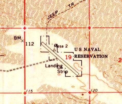
The 1955 USGS topo map depicted a single paved northwest/southeast runway,
labeled as “Landing Strip”, with a narrow property outline of the “U.S. Naval Reservation”.
"Holtville Aux (Navy)" was still depicted as an active airfield
on the 1955 San Diego Sectional Aeronautical Chart (courtesy of John Voss).
The "Aerodromes" table on the chart described the field as having a single 4,000' asphalt runway.
"Holtville Aux (Navy)" was still depicted as an active airfield
on a 1963 World Aeronautical Chart (courtesy of Chris Kennedy).
The length of the runway as depicted on the chart appears to be erroneous - it is listed as 40,400 feet!
Strangely, "Holtville Aux (Navy)" was still depicted as an active military airfield
on the 1966 San Diego Sectional Chart (courtesy of Chris Kennedy),
even though its parent airfield, the former NAAS Holtville, was depicted as a civil (not military) airfield.
Jim Walker reported, “Since I've lived in California's Imperial Valley all my life,
I'm very familiar with the old Holtville Airstrip & the paved strip to the east (Sand Hill NOLF).
Sometime during the 1960s, I was told by a local doctor that while he was cruising the desert in his dune buggy
he stopped at the airstrip east of Holtville.
While he was there, a Navy fighter came in & landed.
The pilot shut down, got out & came over to where the doctor was parked.
After having a beer & visiting for a while, the pilot climbed back in his plane & flew away.”
"Holtville
Aux (Navy)" was still depicted as an active military airfield on
the March 1967 San Diego Sectional Chart.
The Sand Hill airfield was evidently abandoned at some point in 1967,
as it was no longer depicted on the August 1967 San Diego Sectional Chart.
The Sand Hill runway was depicted on the 1979 USGS topo map, labeled simply "Landing Field".
It was also depicted on the 1989 USGS topo map, labeled "US Naval Res".
According to Navy pilot Mike Strobach, "When I was flying helicopters out of North Island,
we would fly to this abandoned field at night & practice landings with night vision goggles.
This was several years ago, but I'm sure they still do this type of training there. We called the strip 'Old Holtville'".
A 1996 USGS aerial view looking north showed the Holtville / Sand Hill airfield to consist of a single 4,000' runway, very deteriorated.
It is not apparent if any buildings were constructed at the field.
Francis Blake reported in 2003 that Sand Hill "has been used recently.
The southern end has been blown free of all sand & debris indicating helicopter landings,
and there are numerous fired military cartridges of recent manufacture lying on the runway.
I found dated military items from 1942-62 at Sand Hill.
Because Sand Hill is apparently still Navy property (based on the current Auto Club Imperial County map),
it is my guess that Navy Seals or Marine Air Assault units are practicing there."
Roger Hillhouse reported in 2006, “Ownership [of the Sand Hill airfield]
still resides with the Navy, NAF El Centro being the landlord.
I had several talks with MCAS Yuma trying to get them to take ownership
in order to use the field as an expeditionary field for C-130s.”
Woodrow Anselen reported in 2008, “I made the decision to fly to Sandhill,
a field I have viewed from the air many times as I fly my B 737 from San Diego to Houston.
The field lies about 8 miles east of Holtville in an utterly featureless desert plain.
My only guidance was an ill-remembered dirt road that led, more or less, from Holtville to Sandhill.
The problem was, was that there were 2 ill-defined trails.
Evidently, I must have picked the right one, for in a short while the vague outline of the runway hove into view.
I made a standard, but low level pattern, and decided to check out the runway condition before attempting a landing.
I made several south to north passes, and was disappointed by what I saw.
The approach end (south to north) had some broken pavement where the previously seen markings had been painted.
More importantly, what appeared in the Google Earth pictures as small tumbleweed like plants,
were in fact very substantial bush/trees many reaching easily 10-12 feet in height!
Try as I might, I just could not find a suitable landing spot without incurring undue risk.
The southern-most portion held the most promise, as the left side was relatively free of the large monster bushes,
but the there were several white painted tires laying there which could have posed a risk.
Perhaps they have been deliberately placed there to discourage a landing?
Further down the field there was another 'clear' spot some 200 feet long, but unfortunately this consisted of badly broken pavement.”
Woodrow continued, “Try as I might (and I certainly tried, having come a very long way) I simply could not risk a landing.
My decision was based on a combination of runway conditions, existing vegetation & wind & density altitude considerations.
Perhaps if I had arrived much earlier in the day, when wind & temperatures were not so high,
I might have attempted a landing, but I could just see damaging my airplane there & then what?”
A 2008 photo of the Sand Hill runway by Woodrow Anselen (enhanced by Bill Grasha).
Woodrow observed, “The absolute loneliness & desolation of this place is difficult to grasp.
It lies abandoned & unknown in a harsh environment where it has slept away the decades for who knows how long.
How strange it must have seemed to have an aircraft appear & make several low passes.
I can tell you that its image of solitude will remain with me,
and the knowledge of its existence will haunt my nightscapes & dreamscapes in ways that twist my mind & fill me with morbid desolation.”
A undated photo (courtesy of Chris Kennedy, enhanced by Bill Grasha) showing the Holtville (Sand Hill) Carrier Landing Strip
before the June-September 2013 vegetation clearing by Marine Wing Support Squadron 74.
The October 2013 issue of the NAF El Centro Sandpaper (courtesy of Chris Kennedy)
had an article entitled “Marines Clear NAF El Centro’s Holtville Carrier Landing Strip of Creosote Shrubs”.
It read, “On June 13-17, and again on September 9-13, 2013, Marines from Marine Wing Support Squadron 74,
supported by staff from NAF El Centro’s Environmental Division office,
cleared the full 4,000' length of the old Holtville Carrier Landing Strip of all vegetation.
The vegetation clearing will provide better access to the Strip for ongoing rotary-wing aircraft operations & pilot training.
Next will be the renovation & resurfacing of the Strip by the Marines.”
A undated photo showing the Holtville (Sand Hill) Carrier Landing Strip
after the June-September 2013 vegetation clearing by Marine Wing Support Squadron 74 (courtesy of Chris Kennedy).
A 2015 aerial view looking north showed the Holtville / Sand Hill runway looking considerably more cleared compared to the 1996 photo.
Sand Hill is located in an almost featureless part of the Southern California desert,
along an unpaved road (simply labeled "4WD" on USGS topo maps) halfway between the Holtville Airport & the Coachella Canal.
Thanks to Mel Shettle for pointing out this airfield.
____________________________________________________
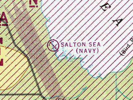
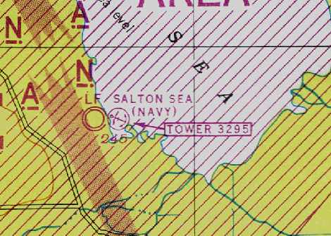
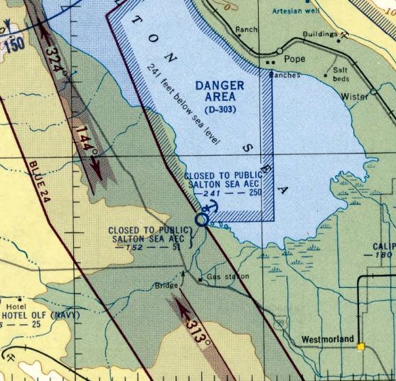
Salton Sea Naval Auxiliary Air Station, Salton Sea, CA
33.188, -115.84 (East of Los Angeles, CA)
The “Salton Sea (Navy)” seaplane base, as depicted on the August 1943 San Diego Sectional Chart (courtesy of Chris Kennedy).
The Navy first used the northeast corner of the Salton Sea in 1939 as a seaplane operational area with bombing targets & for emergency landings.
After the start of WW2, a larger facility was needed, and the Navy constructed a seaplane base at Sandy Beach on the southwest shore of the sea.
In an odd choice to portray a south-Pacific island, in early 1942 Paramount Studios chose the site as the set for location shots for the movie Wake Island.
They constructed a 4,000' clay airstrip on the shoreline one mile south of the seaplane base.
Naval Air Facility Salton Sea was commissioned on 10/8/42.
The base was initially equipped with PBY Catalina twin-engine seaplanes, and was used for seaplane training & as a seaplane ferry stop.
The seaplane base had a 2,100' long asphalt parking apron,
a seaplane ramp leading down into the water, and a small group of buildings.
As the parking apron resembled a runway, it was painted with a large "DO NOT LANDING HERE" warning.
The Salton Sea aviation facility was not yet depicted on the October 1942 San Diego Sectional Chart.
The earliest depiction of the Salton Sea aviation facilities which has been located
was on the August 1943 San Diego Sectional Chart (courtesy of Chris Kennedy).
It only depicted the “Salton Sea (Navy)” seaplane base - but did not depict any landplane airfield.
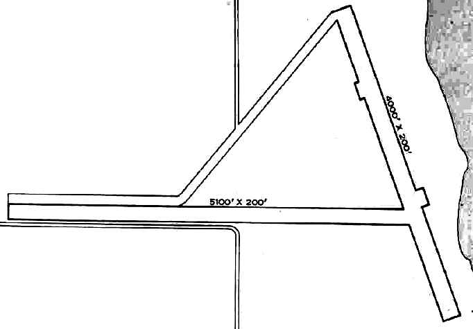
In 1942 & 1943, the Navy improved the original north-south Paramount runway & built a second, 5,100’ east-west runway.
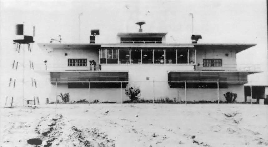
In 1944, to support a new mission of conducting air-to-ground rocket training for carrier-based aircraft,
the Navy added ammunition magazines, a temporary tower, a parking apron, and a taxiway connecting to the seaplane base.
The airfield consisted of 2 clay runways (5,100’ ' & 4,000' long).
VT-20 was the first of 57 squadrons to deployed to Salton Sea for air-to-ground rocket training.
Along with this new mission, Salton Sea was upgraded to a Naval Auxiliary Air Station in 1944.
Barracks were present for a total of 638 personnel.
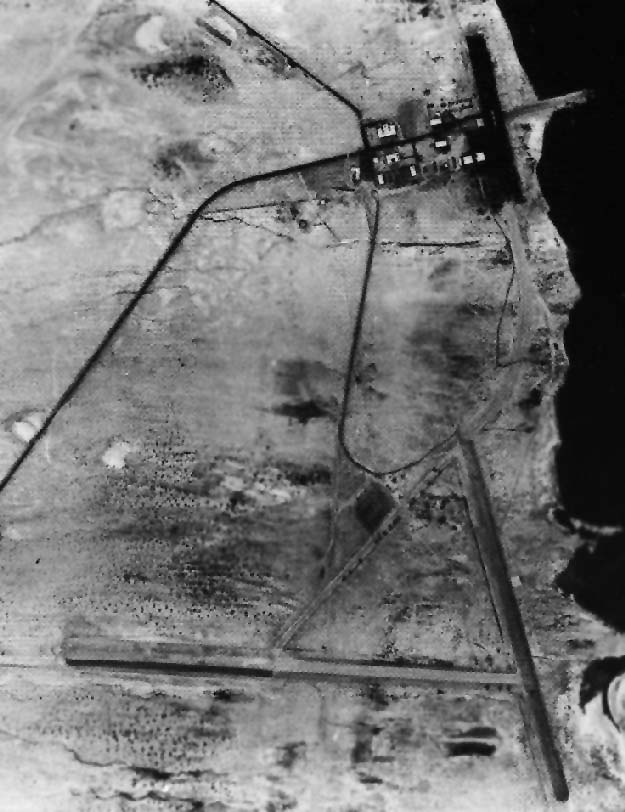
The earliest photo which has been located of the Salton Sea airfield
was a 1944 National Archives aerial photo (enhanced by Bill Grasha) of the Salton Sea seaplane base (north) & landplane airfield (south).
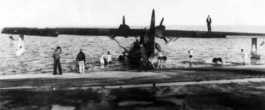
A WW2 era USN photo of a PBY Catalina seaplane launching into the Salton Sea.
Tests were also conducted of Jet Assisted Takeoff rockets (JATO) in 1944.
In that same year, B-29s of the 509th Composite Squadron from Wendover AAF, UT
made over 150 drops of prototype atomic bomb shapes at Salton Sea.
The March 1944 San Diego Sectional Chart (courtesy of Chris Kennedy)
depicted both the Salton Sea Navy seaplane base & landplane airfield.
The 1945 AAF Airfield Directory (courtesy of Scott Murdock) described “Salton Sea Field”
as a 2,250 acre irregularly-shaped property containing 2 dirt & clay runways, the longest being the 5,100' east/west strip.
The field was said to not have any hangars, to be owned by the U.S. Government, and operated by the Navy.
However, the title of the listing said “Inactive”.
Salton Sea was said to have the following auxiliary fields: 06771 Borrego Hotel OLF, 05169 Clark's Dry Lake OLF,
07881 North Coyote Wells OLF, 06469 Ocotillo Dry Lake OLF, and 08872 South Coyote Wells OLF.
According to the article “Lost Aircraft of the Salton Sea” by Joh Halczak in the Summer 2021 AAHS Journal, a number of military aircraft were lost over the Salton Sea in WW2:
13 Grumman TBM Avengers, 4 Grumman FM/F4F Wildcats, 2 Consolidated PBY Catalinas, 1 Consolidated PB2Y Coronado. 2 NAA PBJ Mitchells, 1 Curtiss SBC Helldiver,
2 Curtiss SB2C Helldivers, 3 Grumman F6F Hellcats, 2 Vought F4U Corsairs, and several USAAF P-40s, P-38s, P-39s, and O-52s.
NAAS Salton Sea was disestablished in 1946.
However, it was maintained & manned at a lower level as a emergency seaplane facility until 1967,
when seaplanes left the naval inventory.
After WW2, most of the facilities of the seaplane base were taken over by the Atomic Energy Commission (AEC),
which renamed the facility the Salton Sea Test Base.
The AEC built a 5,100’ clay runway on higher ground one mile west of the seaplane base.
They used the facility to conduct test drops of inert nuclear weapons from 1946-1961.
A 4/21/50 aerial view (from the UCSB Library) showing the former Navy Salton Sea seaplane base (north) & landplane airfield (south).
The "Salton Sea Base (AEC)" airfield & seaplane base were depicted
on the March 1951 San Diego USAF Sectional Chart (according to Chris Kennedy),
but the Aerodromes table described the status of both as "Closed".
Brian Ward recalled, “My father, Stuart Ward, worked at the AEC Salton Sea Test Base during the early 1950s.
He was assigned to the base’s fire department.
Lots of stories about using dummy bombs as stools & tables while eating lunch & watching development of modified German cameras recovered from the war
which, among other uses, were being prepared to track launches into space, since the space race was already ramping up.”
Brian's father related, “While working the night shift, a military airman reported on emergency frequency which we monitored that he was MAYDAY,
and had a loss of power somewhere high above the Salton Sea.
We responded to him that we had an airfield on the western edge of the sea, and would turn the lights on so he could attempt an emergency landing.
The only problem with that was we were at the lodge & the only way to do that was to turn them on at the field hut which was by the 5,100’ runway a mile away to the west.
It was very rare to have a night operation & instructions were to leave lights off. I jumped in one of the base vehicles & tore over there to throw the switch.
When I finally got over there an did that, the airman radioed back immediately with obvious enthusiasm that the airport just lit up right below him.
He dead-sticked it right in & walked away shaken but not stirred.”
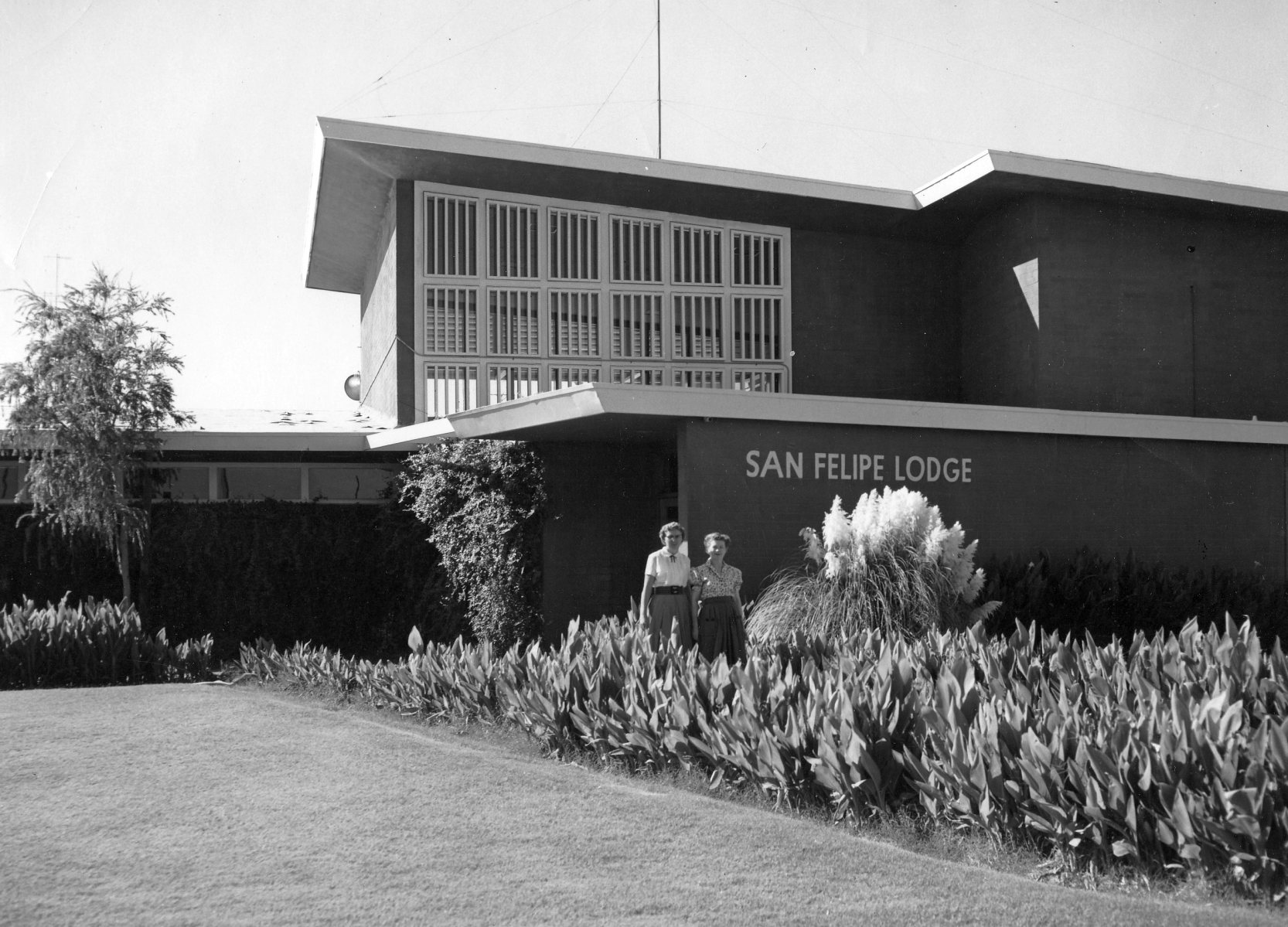
A 1950s Sandia Labs photo (courtesy of Brian Ward) of Salton Sea's “main recreation facility, the San Felipe Lodge, which had a beautiful pool outside & nice amenities.”
The last aeronautical chart depiction which has been located of the Salton Sea Navy air facilities was on the March 1954 San Diego Sectional Chart.
It labeled both the airfield & seaplane base as "Closed to public, Salton Sea AEC", and specified the length of the airfield runway as 5,100'.
The Salton Sea Airfield was evidently closed at some point in 1954,
as it was no longer depicted at all on the September 1954 San Diego Sectional Chart (according to Chris Kennedy).
According to a 1995 report (according to Mike Friese), “The Dog Site Building (4070, Sites 7 & 9) was constructed in 1954 to support the NETP activities.
The building was used for environmental testing of weapons & maintenance, and for recording data.
The weapons were tested by exposure to natural conditions outside. Different types of storage protection were used.
Weapons components, including mechanisms containing depleted uranium & explosives, were disassembled, inspected, and reassembled in the building to evaluate the effects of environmental exposure.
The weapons did not contain fissionable materials (i.e., enriched uranium, plutonium).
The test program was completed in November 1959.”
An undated photo of the Salton Sea Test Lab (courtesy of Rex Ricks).
The AEC ended Salton Sea operations about 1961.
The Salton Sea facility was taken over by NAF El Centro,
which conducted parachute drop tests for the manned space program & other military systems until 1979.
In the postwar period, the continuing rise of the waters of the Salton Sea were a perpetual problem,
and a series of dikes were built to prevent the Test Base from being flooded.
However, the were no dikes to protect the Navy runways south of the base.
The Marines & Navy SEALs have also used the isolated location for training exercises, and a Marine CH-53 reportedly crashed in 1979.
The former movie-set airfield was depicted as "Landing Strip" on the 1976 USGS topo map,
but the Navy airfield wasn't depicted at all.
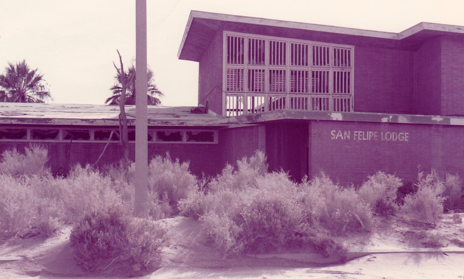
A January 1985 photo (courtesy of Brian Ward) of Salton Sea's main recreation facility, the San Felipe Lodge, the same perspective as the 1950s picture.
Brian reported the picture was “from some scouting my father & I did there. Pretty much all the buildings were still intact, and the pool was there, but empty of course.
He showed me the barracks where most of the men lived.”
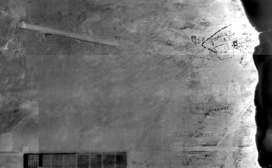
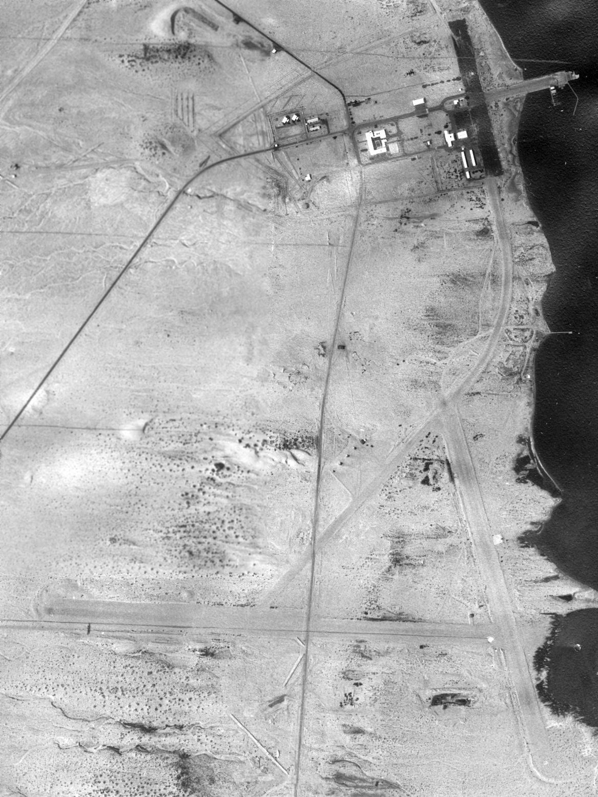
An overview from the 1992 USGS aerial photo of Salton Sea NAAS, showing the 2 airfields & the test base.
Top left is the AEC strip, top right is the former seaplane base & test base, lower right are the partially submerged Paramount/Navy runways.
As the water level of the Salton Sea has risen,
the shoreline has moved about a thousand feet toward the west from 1944-1992.
As a result, much of the eastern portion of the former seaplane base (including the 2,100' parking apron) has been submerged.
An October 1994 photo (courtesy of Mike Friese) captioned “Salton Sea Test Base Weapon Assembly Building 4070 (Dog Site Maintenance Facility)”.
The former movie-set airfield was depicted as "Landing Strip" on the 1995 USGS topo map, but the Navy airfield wasn't depicted at all.
As of 2002, the Salton Sea base was totally abandoned,
and will probably eventually be incorporated in the adjacent wildlife refuge.
Neither Salton Sea airfield was still depicted (even as an abandoned airfield) on 2002 aeronautical charts.
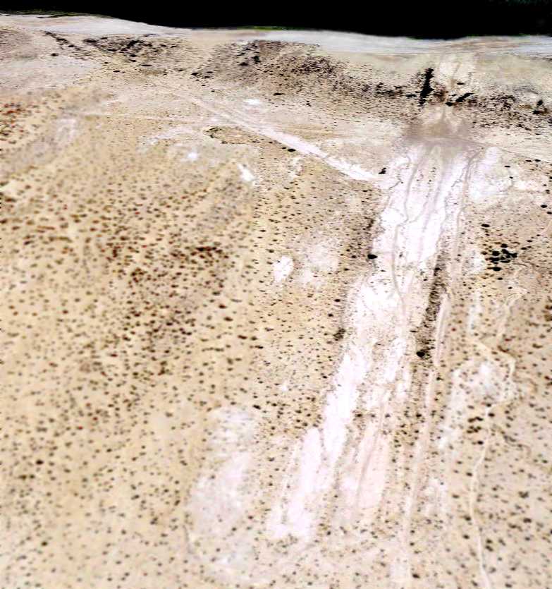
Francis Blake reported in 2003 that the Wake Island movie set runway
"was being used a few years ago by the company demolishing the navy base.
Just west of there, the 1943 Humphrey Bogart war movie Sahara was filmed.
I searched for & found the site in 1996 then wrote about it for a magazine."
He also reported that "Except for the runways, a few whole ammo bunkers,
a partially submerged building on the Sea side of the dike, and the submerged pier,
nothing now remains at the old Salton Sea base."
Tim Tyler visited the Salton Sea Test Base site in November 2004.
He reported: "The paved access road leading to the Southern part of facility is washed out about 1.5 miles in by sand drifts,
so we saw nothing but desert & dunes,
plus a modern sign warning that the grounds of the former Salton Sea Test Base could have unexploded ordnance.
We proceeded a little further north on CA-86 & tried turning right into the former base again.
The paved road had been removed, so we drove slowly on a dirt/sand trail,
heading east to the Sea in the hopes of finding some sort of remains.
According to my GPS/Street Atlas USA, we were on the 'road' which led into the site,
but is was a very rough & rugged 4WD track.
We did pass in between the collapsed wooden remains of 2 small wooden structures (perhaps sheds),
and an old U.S. Government Property - No Trespassing sign that was all shot-up
(looked like many 5.56mm or 0.308 rounds, and one or two 0.50s).
We were making very slow progress towards the water, where I’d hoped to come across SOMETHING to justify the ordeal -
the old seaplane ramp, a concentration of building foundations, inert ordnance, etc.)
but alas, about 10 seconds after I seriously developed the feeling of 'Oh geeze, we need to get out of here before we get stuck',
we got stuck in the sandy dirt, about a third of a mile west of the water.
After 2 hours of trying to free ourselves, sunset was only a half hour away, so I figured I’d better make a phone call.
I was on the phone with a wrecker service trying to explain where we were
(of course, I could give him our exact coordinates to within about 9’, but they didn’t have GPS)
when an old-timer with a pickup truck pulled up & confidently stated he could assist us.
Turns out he’s been coming to the area for decades, and was camping out about a mile away.
After seeing that our vehicle hadn’t moved in 2 hours, he figured we were stuck,
so this great Samaritan came on over, and using his tow strap & mine, we finally got my vehicle free."
Tim continued, "While stuck, I could see the beat up, barely standing remains of 2 wooden structures
that appeared to be right along the water, and about half a mile apart.
The old-timer told me pretty much what I’d already known -
the buildings had been demolished either by military training action, or contractors, but that ordnance is still occasionally found.
Apparently the main entrance road (Salton Sea Test Base Road) was a couple miles further north on CA-86,
just a mile or so outside of the southern outskirts of Salton City,
but now there’s simply about 10’ of pavement running east off of CA-86, then the pavement stops & it’s dirt/sand,
which gets softer the closer you get to the water.
The Salton Sea is 200+ feet below sea level, and it’s fed simply by runoff from all of the agriculture crops in the valley.
There is no sign of who owns the former SSTB land, but I understand some is BLM property,
and I good chunk of it is in private hands.
About the only activity that takes place there now is off-road 4WDing & dirt bikes,
which seems to be the predominant recreational activity for the entire region
plus the occasional idiot driving around in a yuppie-type 4WD to look at the old military site!"
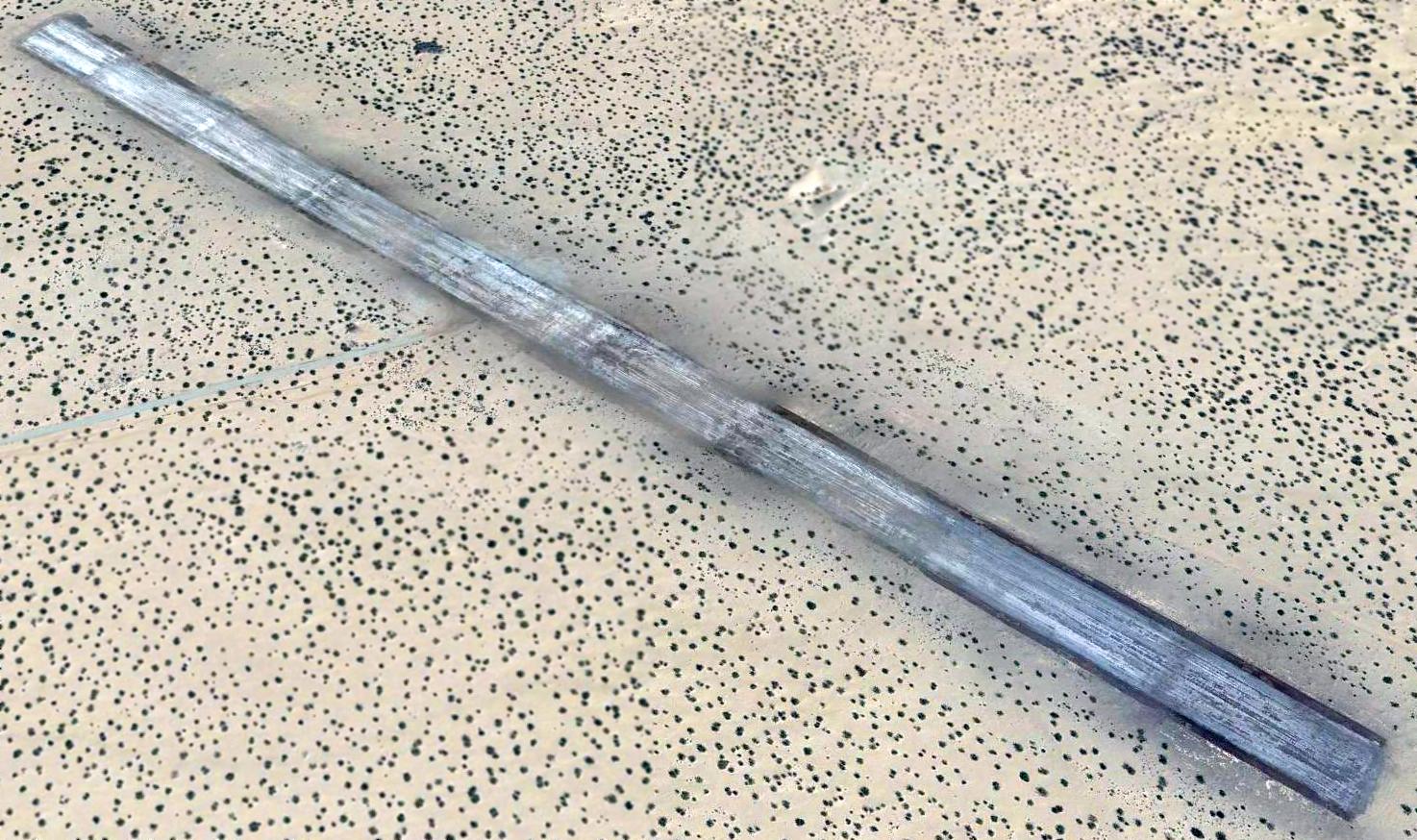
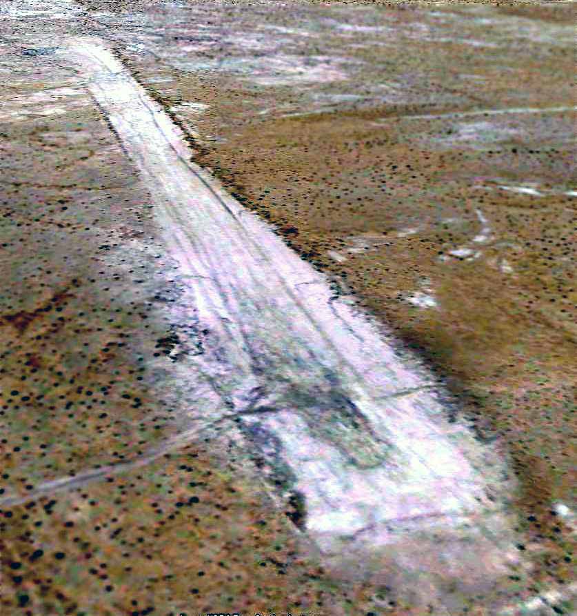
A January 2007 photo by Kurtis Clark (enhanced by Bill Grasha) looking along the remains of the single runway on the west side of NAS Salton Sea (also referred to as the AEC airfield).
Kurtis reported, “My understanding is that the area has been returned to the BLM.
It was all open access except at the site of the Sea Base, where they built ponds to remove salt from the lake (failed experiment).
That area was signed 'No Trespassing'.”
A January 2007 photo by Kurtis Clark of “several parts [found] in the sand, apparently from aircraft.
They are clean just from the natural sandblasting they receive.”
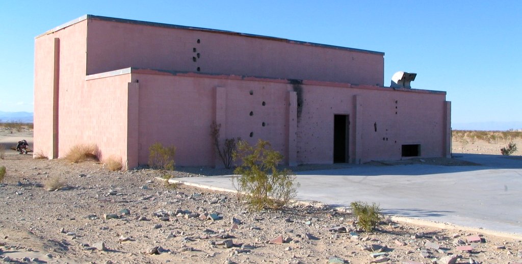
A January 2007 photo by Kurtis Clark of the Weapon Assembly Building “near the west end of the runway.”
A January 2007 photo by Kurtis Clark of the interior of the Weapon Assembly Building.
Kurtis observed, “It still has an overhead crane.”
A 5/25/09 aerial view looking northeast at the remains of the Salton Sea NAAS landplane airfield.
The north/south runway of the former Navy landplane airfield had been submerged.
The remains of the east/west runway & the taxiway were still barely discernible.
As seen in a 5/25/09 aerial view (enhanced by Bill Grasha) looking southeast, the former AEC airfield consisted of a single 5,100' east/west runway.
A 2009 photo of a bunker at the site of Salton Sea NAAS.
Mike Friese reported in 2018, “I have wandered the Salton base on a couple of trips.
Building 4070's roof is now missing & the gantry & all the steel inside structures are gone.
The outside was pink & the inside showed outlines of all the metal structures removed.”
Thanks to Jeffery Sternberg for pointing out this airfield.
____________________________________________________
Since this site was first put on the web in 1999, its popularity has grown tremendously.
If the total quantity of material on this site is to continue to grow,
it will require ever-increasing funding to pay its expenses.
Therefore, I request financial contributions from site visitors,
to help defray the increasing costs of the site
and ensure that it continues to be available & to grow.
What would you pay for a good aviation magazine, or a good aviation book?
Please consider a donation of an equivalent amount, at the least.
This site is not supported by commercial advertising –
it is purely supported by donations.
If you enjoy the site, and would like to make a financial contribution,
you
may use a credit card via
![]() :
:
Please consider checking the box to make a monthly donatation.
For a mailing address to send a check, please contact me at: paulandterryfreeman@gmail.com
If you enjoy this web site, please support it with a financial contribution.
This site covers airfields in all 50 states.