
Abandoned & Little-Known Airfields:
California: Bakersfield Area
© 2002, © 2024 by Paul Freeman. Revised 1/1/24.
This site covers airfields in all 50 states: Click here for the site's main menu.
____________________________________________________
Please consider a financial contribution to support the continued growth & operation of this site.
For the 8th year, the CA pages of this website are sponsored by the California Pilots Association:
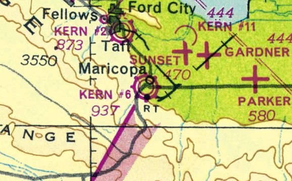
Gardner AAF / Gardner Airport (revised 1/1/24) - Gardner Aux AAF #1 / Parker Field (revised 12/15/18) - Gardner Aux AAF #2 / Taft-Kern Field (revised 6/25/22)
Gardner Aux AAF #3 / Allen Field (added 3/3/14) - Gardner Aux AAF #6 / Cuyama Airport (revised 5/28/21) - La Cresta Airport (revised 7/5/18)
Maricopa Airport (original location) / Kern #6 Airport / Maricopa-Kern Airport (revised 12/31/23) - Maricopa Airport (2nd location) (revised 1/1/24) - Minter Aux AAF A-2 / Pond Field (revised 8/15/17)
Minter Aux AAF A-3 / Famoso Field (added 2/1/13) - Minter Aux AAF A-4 / Dunlap Field / Jasmin Landing Field (revised 2/1/13)
Minter Aux AAF A-5 / Semi-Tropic Field (added 2/2/13) - Rio Bravo Airport (revised 1/1/24)
____________________________________________________
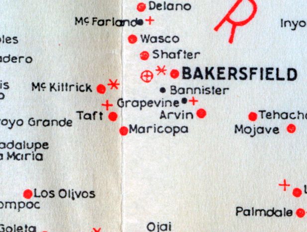
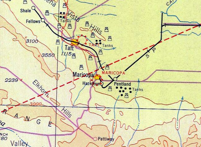
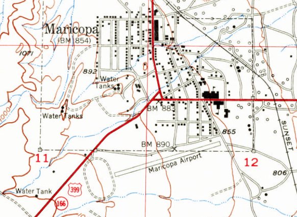
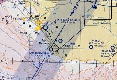
Maricopa Airport (original location) / Kern #6 Airport / Maricopa-Kern Airport, Maricopa, CA
35.054, -119.401 (Southwest of Bakersfield, CA)
The original Maricopa Airport, as depicted on the 1927 Landing Fields of the Pacific Coast (courtesy of the Museum Of Flight).
The original airport for the town of Maricopa was located adjacent to the south side of the town.
The date of establishment of Maricopa Airport has not been determined.
The earliest depiction which has been located of Maricopa Airport was on the 1927 Landing Fields of the Pacific Coast (courtesy of the Museum Of Flight).
The
1931 Landing Fields of the Pacific West (courtesy of
Jonathan Westerling) described Maricopa as a commercial
airport operated by the Exchange Club,
measuring 2,500' square, and have 3 triangular smooth runways.
The earliest aeronautical chart depiction which has been located of Maricopa Airport was on the 1932 LA Airway Chart (courtesy of Jonathan Westerling),
which depicted Maricopa as a commercial/municipal airport.
The earliest photo which has been located of Maricopa Airport was a 1936 aerial view (courtesy of Jonathan Westerling).
It depicted 2 unpaved runways, but there were no hangars or aircraft visible.
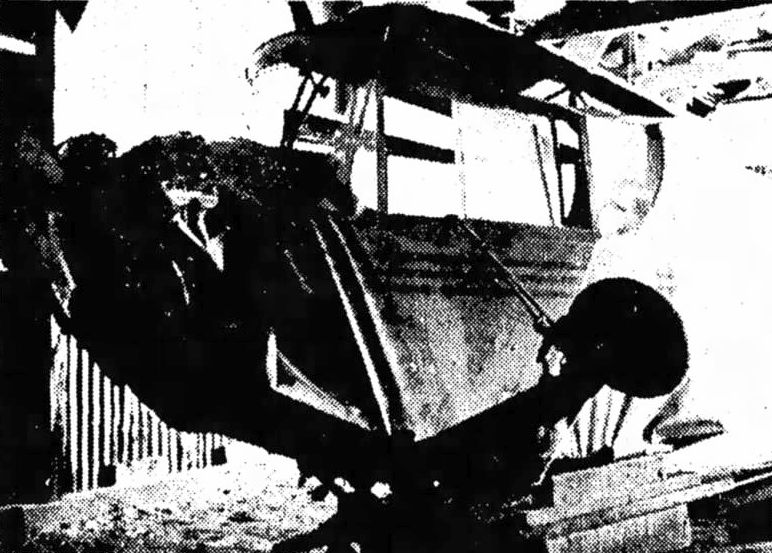
An undated photo from the 6/15/39 Bakersfield Californian (courtesy of Jonathan Westerling) of a light single-engine aircraft that crashed at Maricopa Airport in a downdraft.
Jonathan Westerling reported, “The airport was transferred to Kern County in 1943 & thereafter referred to as Kern County Airport #6.”
A 1946 aerial view (courtesy of Jonathan Westerling) depicted Maricopa Airport / Kern County Airport #6 in an unchanged configuration.
The 1949 CA Aeronautical Chart (courtesy of Jonathan Westerling) depicted “Kern #6” as a commercial/municipal airport.
The earliest topo map depiction which has been located of Maricopa Airport was on the 1950 USGS topo map.
It depicted Maricopa Airport as having a paved northeast/southwest runway, with one small building on the northeast side.
The last photo which has been located of “Maricopa-Kern County Airport” was an undated aerial view looking north from the 1950 CA Photo Guide (courtesy of Jonathan Westerling).
It described Maricopa as having a single 2,800' Runway 6/24, and to be managed by C.C. Meadows.
The last aeronautical chart depiction which has been located of “Maricopa-Kern Co” Airport was on the March 1953 Sectional Chart (courtesy of Jonathan Westerling).
It depicted Maricopa as having a 2,800' unpaved runway.
The
original Maricopa Airport was abandoned at some point between March
-September 1953, as it was no longer depicted on the September 1953
Sectional Chart (according to
Jonathan Westerling).
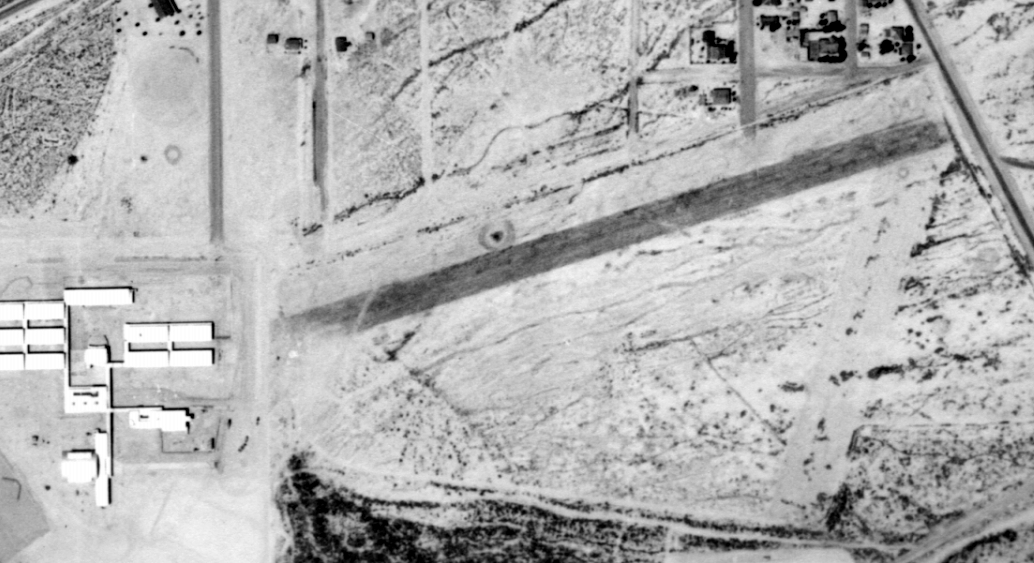
A 6/23/56 USGS aerial view showed the Maricopa Unified School had been built at some point between 1952-56 over the western portion of the runway,
but remains of the runway extended toward the northeast.
The 1965 USGS topo map continued to depict Maricopa Airport in an unchanged fashion.
A replacement Maricopa Airport was eventually built 1/3 mile to the west.
A 1976 USGS aerial view still showed the remains of the eastern portion of the Maricopa Airport runway.
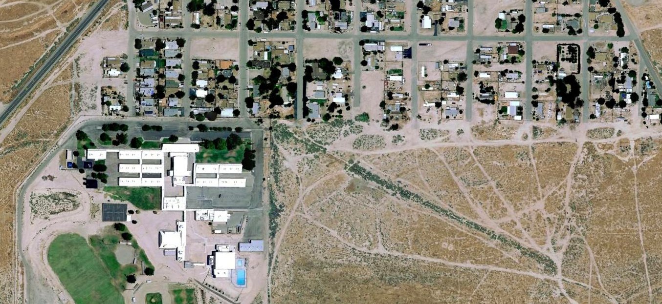
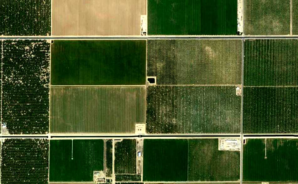
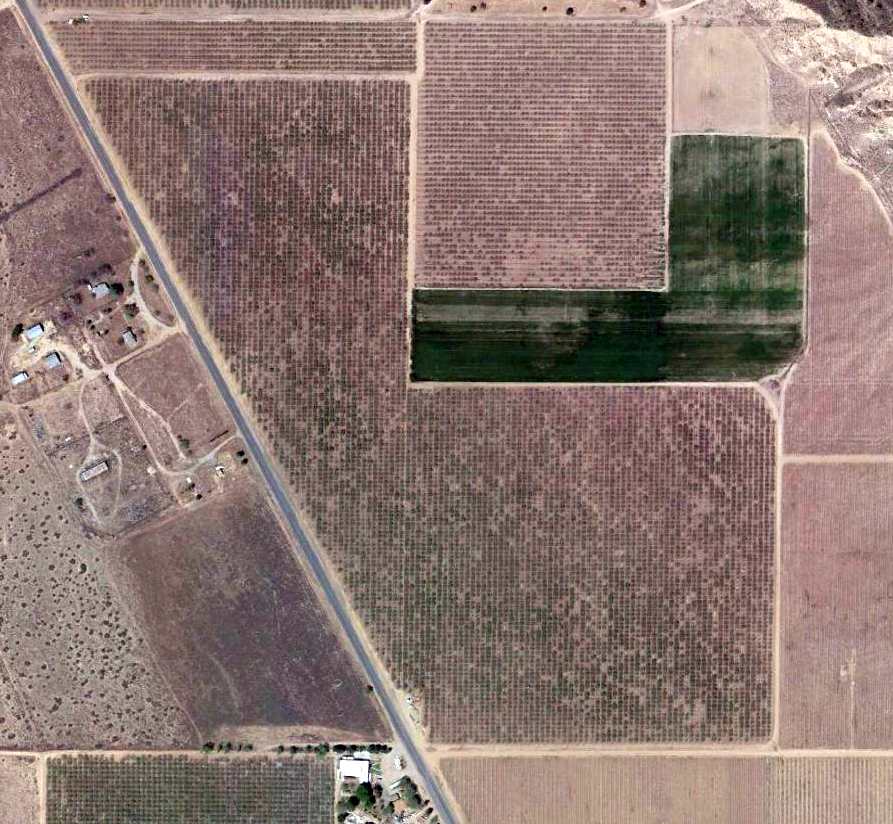
A 2017 aerial photo showed no trace remaining of the original Maricopa Airport, with the property occupied by the Maricopa Unified School & houses.
The site of the original Maricopa Airport is located at the southern terminus of Southern Kern Street.
____________________________________________________
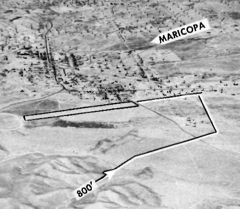
Maricopa Airport (2nd location), Maricopa, CA
35.053, -119.412 (Southwest of Bakersfield, CA)
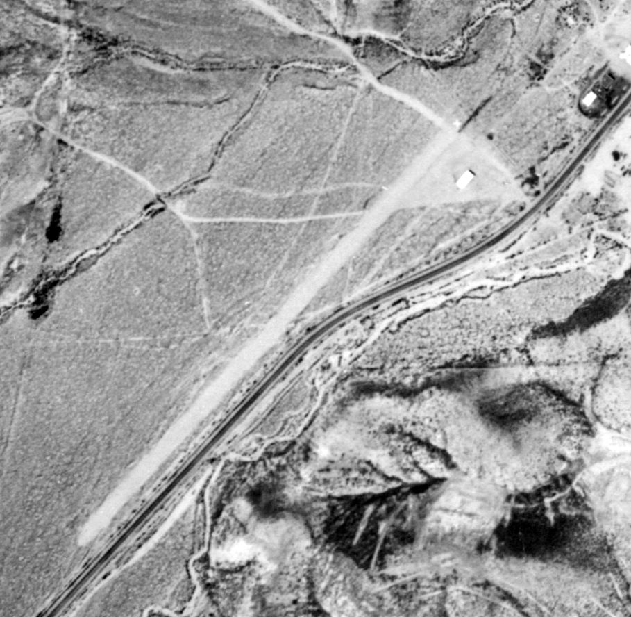
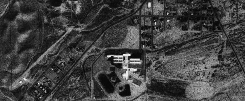
The 2nd location of Maricopa Airport, as depicted on a 1956 aerial view (courtesy of Jonathan Westerling).
Jonathan Westerling reported, “When Kern County decided to build a new school on the location of the original Maricopa Airport,
a new runway & hangar were constructed just to the west & on the other side of Route 166.”
The earliest photo which has been located of the 2nd location of the Maricopa Airport was a 1956 aerial view (courtesy of Jonathan Westerling).
It depicted a 2,000' northwest/southwest unpaved runway, with a closed-runway “X” symbol on the northeast end, and 1 building (a hangar?) on the northeast side.
Jonathan Westerling reported, “At some point in the following 10 years, the runway was moved slightly further north on the other side of a wash,
so the landing aircraft would not fly over new housing being built adjacent to the highway.
It appears the hangar was also moved to the new runway location.”
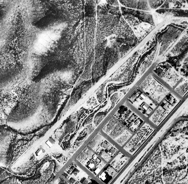
A 5/16/67 USGS aerial view depicted the 2nd location of the Maricopa Airport as an unpaved northeast/southwest runway,
with 2 small buildings on the south side.
The 1973 USGS topo map depicted the 2nd location of the Maricopa Airport as an unpaved northeast/southwest runway, labeled simply as “Landing Strip”,
with 2 small buildings on the south side.
The 2nd location of Maricopa Airport was not depicted at all on aeronautical charts from the 1970s through subsequent decades.
Jonathan Westerling observed, “Despite being on county property that is purposely cut out from the town's borders,
the 2nd location of the Maricopa airport does not appear to have ever been charted nor does it appear in any directories.
The initial 2,000' runway length was since shortened to 1,500'.”
A 1976 USGS aerial view depicted the 2nd location of the Maricopa Airport on the left side, with a northwest/southwest runway & 2 small buildings on the south side.
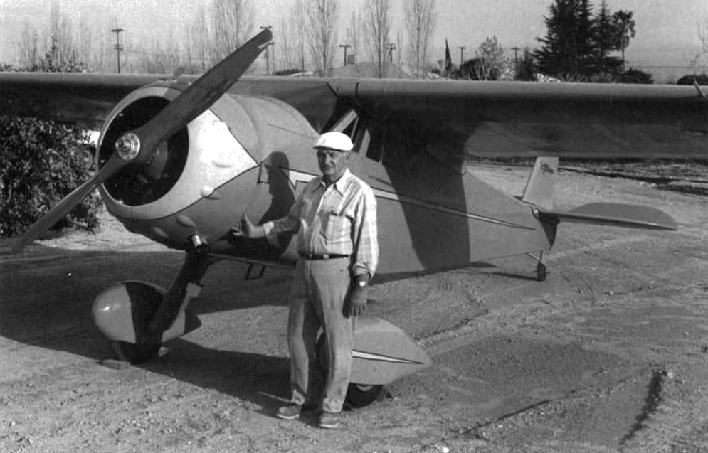
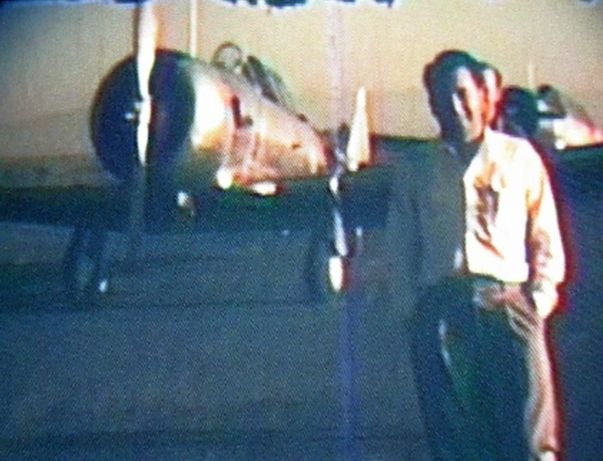
The only photo which has been located of an aircraft at the Maricopa Airport was a 1986 photo of Wayne Smith & his 1937 1937 Cessna C-37 Airmaster, NC18599, S/N 384, which he restored at Maricopa Airport (courtesy of Jonathan Westerling).
According to an August 1986 Vintage Airplane Magazine article, Smith was a pilot since 1939, and was an Industrial Arts teacher at Maricopa High School.
A 1994 USGS aerial view looking north depicted the 2nd location of the Maricopa Airport as having northwest/southwest runway & 2 small buildings on the south side.
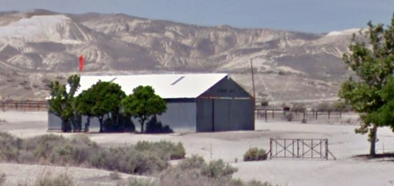
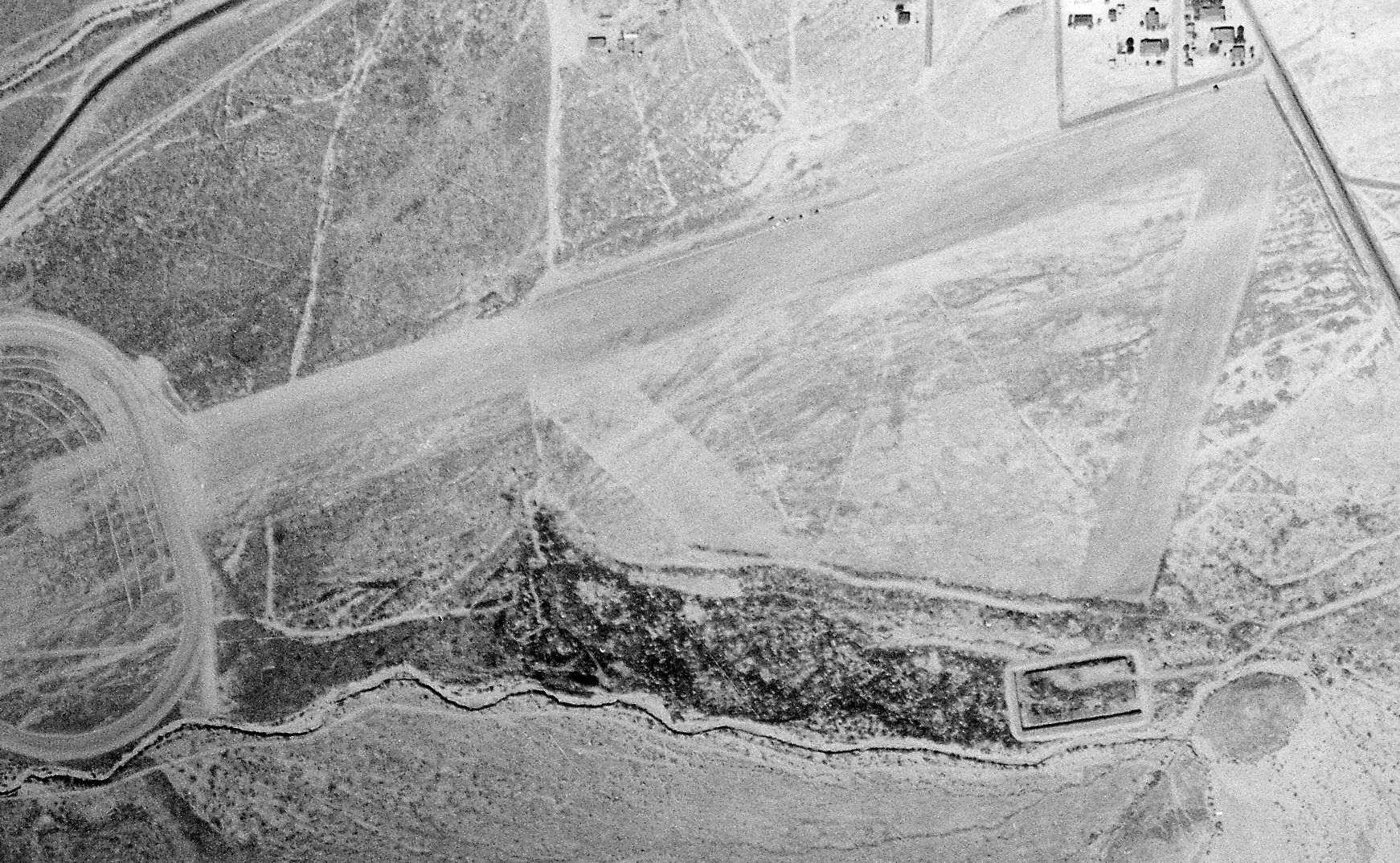
A 2012 photo looking west at a former hangar that still had a red windsock on the west side of the 2nd location of Maricopa Airport.
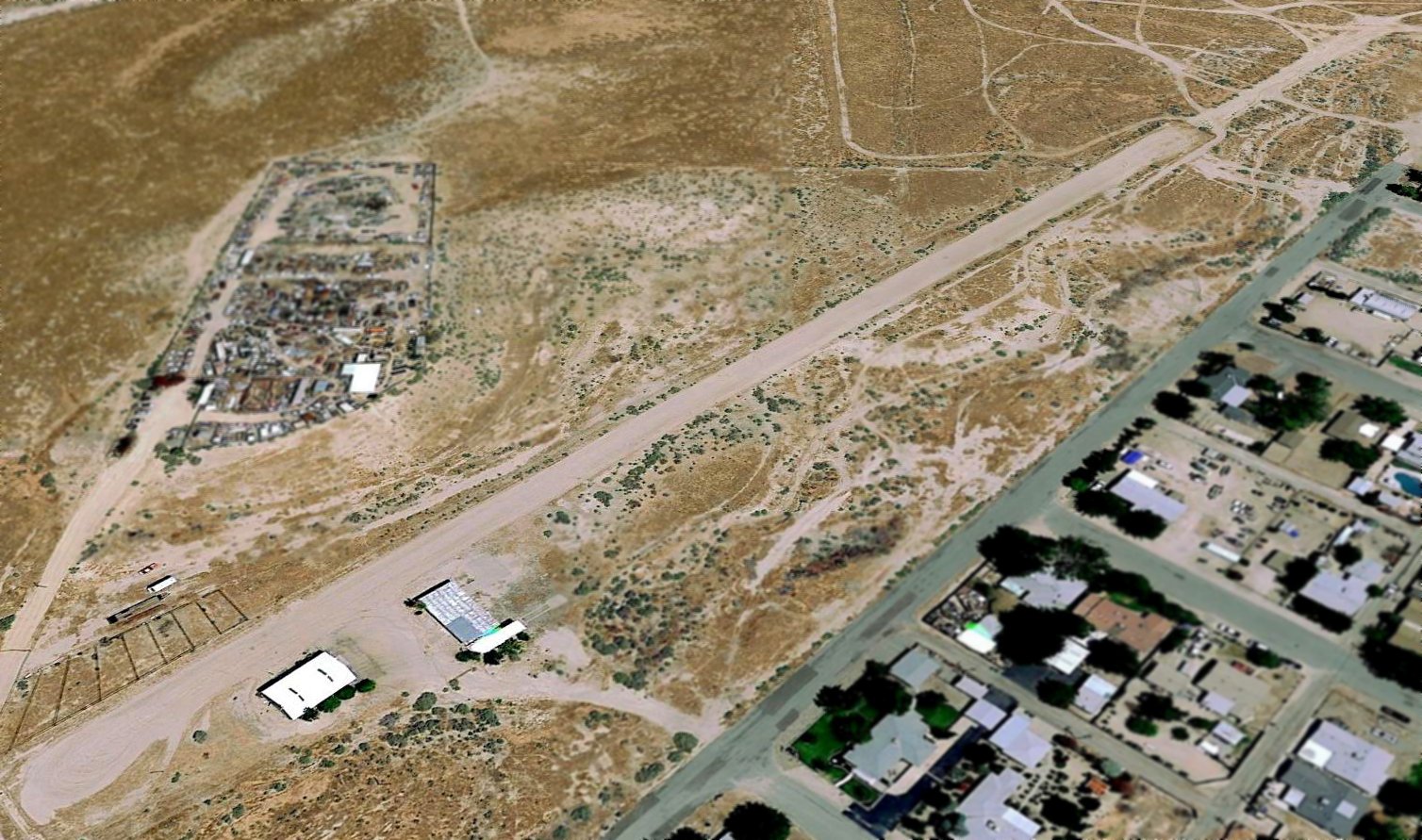
A 2017 aerial view looking north depicted the 2nd location of the Maricopa Airport as having northwest/southwest runway & 2 small buildings on the south side.
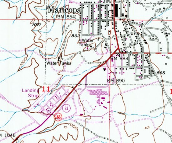
As of 2017, street maps show the town boundaries of Maricopa strangely are situated with a narrow cutout to preclude the runway of Maricopa Airport, presumably for tax reasons.
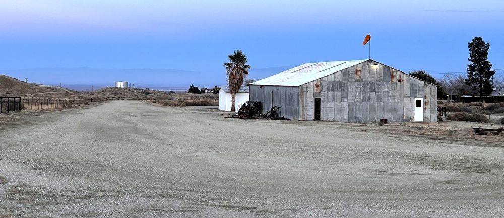
A 2023 photo by Jonathan Westerling looking northeast at Maricopa Airport.
Jonathan reported, “The runway remains in good shape, and appears to be usable as an airfield. However, it is not registered as an active airport.”
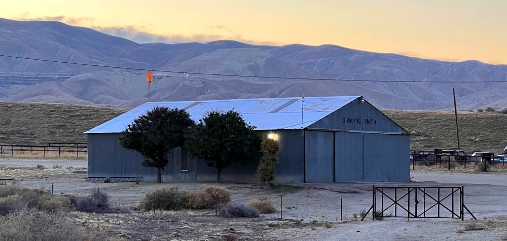
A 2023 photo by Jonathan Westerling looking west at the Maricopa Airport hangar, which still has “D. Wayne Smith” painted, and a red windsock.
The 2nd location of Maricopa Airport is located at the western terminus of Cover Street.
Thanks to John King for pointing out this airfield.
____________________________________________________
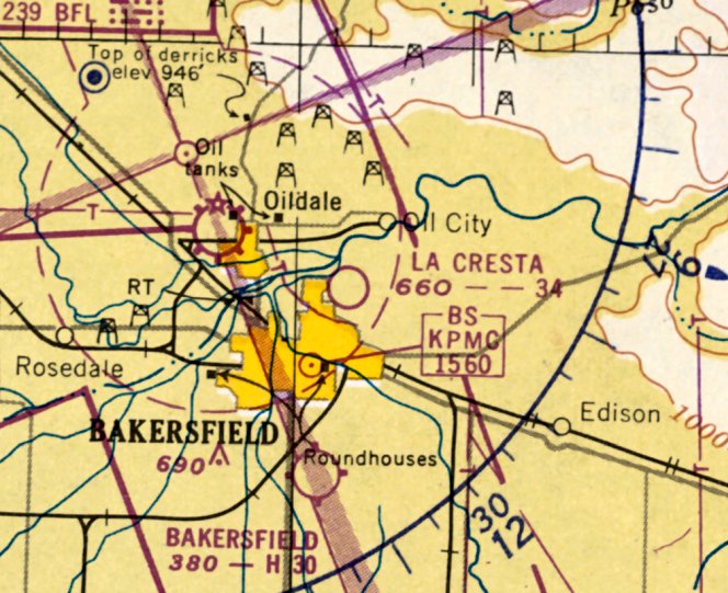
La Cresta Airport, Bakersfield, CA
35.408, -118.981 (Northwest of Central Bakersfield, CA)
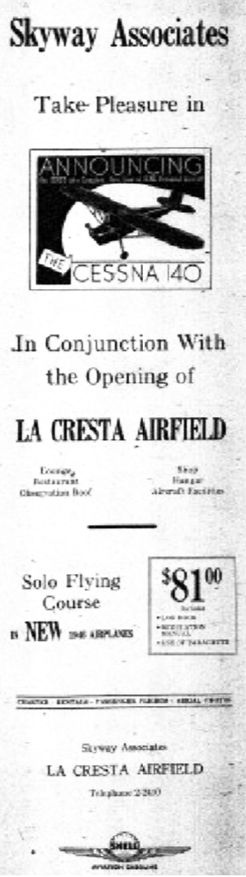
An advertisement promoting the 5/11/46 Grand Opening of La Cresta Airfield.
According to Gilbert Gia, “Brian Landis wrote to The Californian that during or just after World War I
the Army Signal Corps built an airport at the [eventual] site of La Cresta Airfield.”
Landis wrote, "The La Cresta strip was used basically as a safe place to land when needed & for refueling.”
According to Gilbert Gia, “By 1920 [H.H. 'Dutch' Holloway] operated an air service & flying school in East Bakersfield
and in March 1922 started flights to Los Angeles from Holloway Field, west of Baker Street.
It is likely that the La Cresta strip Landis described was Holloway Field on Bernard.”
According to Gilbert Gia, “Interviews with East Bakersfield residents who knew the bluffs in the late 1930s
suggest that an airstrip was first in use there sometime between 1938-41.
Dean VanZant, a Bakersfield Junior College engineering student in 1942, recalled that the field was laid out that year,
and shortly later someone asked his field class to move their surveying practice farther away.”
VanZant wrote, “They had about half-dozen aircraft there.
The runway ran north/south, and at the point of takeoff at the bluffs, planes cleared the road by 100-150'.
I had my first car then [1942]. Before that, when I rode my bike on the bluffs, there was no airport there.”
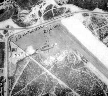
Roxana Francis wrote, “The airstrip was called Monty's La Cresta Airfield.
It was along the east side of River boulevard across from the cemetery.
The strip ran from Panorama to maybe Acacia. The strip wasn't very wide.
You took off north & had to clear the traffic on Panorama.”
Dean VanZant recalls that La Cresta had an airport operations office.
“I don't think there were any hangers or other cover for airplanes. There were no landing lights.”
According to Gilbert Gia, "When Ralph Smith & partners opened La Cresta Airfield just east of Greenlawn Cemetery
they hired John 'Monte' Montijo to manage it.
Monte had been nurtured in a flying background & in fact was named after his father, John 'Monte' Montijo,
who had been an Army flight instructor during WWI, a stunt pilot for Goldwyn Studios, and the man who qualified Amelia Earhart's solo.
During WWII his son, young Monte Montijo, was assigned to the 353rd Fighter Squadron in Europe where he flew P-51 Mustangs.
Monte’s fighter experience made him immanently qualified to teach flying under the GI Bill.
By 1946 La Cresta Airfield was busy teaching veterans & storing & repairing aircraft.”
According to Paul Milazzo, ”La Cresta Airport... The parking & office were on the southeast corner of River Boulevard at Panorama Drive.
The strip ran from that corner where the old 76 service station building still stands & ran southeast from that point.
My father (Alfred Milazzo) was manager of McCart & Bultman furniture store & was also the store's pilot.
They had a Piper twin for traveling to markets.
He gave me my first ride from that strip in probably around 1945-47. We taxied out to the southeast end & took off into the breeze from the northwest.
It was a single-engine plane the airport leased out.
I think that strip was demolished simply for housing & probably thoughts of Bakersfield College being built.”
John Bresnahan recalled, "I learned to fly out of Kern County Airfield in 1945 & received my license in 1946.
Shortly thereafter, I noticed the construction of La Cresta airfield, and upon its completion, I moved my PT-19 to La Cresta because I lived in the immediate area.
I was 16 at the time, and my dad & I flew out of La Cresta into 1949.
I met Jim French, and even flew my Fairchild to Arvin on two occasions to swamp for Steve Straub.
My flying buddy at the time was Jim Bowers, and he parked his PT-15 next to me just beyond the gas island.
I remember the P-40 that Monte bought & sold to the Mexican Air Force (I was told).
In 1949 Jim discovered cracks in my Fairchild, and that ended that.
When I found out that they tore it apart & sold the parts, I was crushed.
I would have stored it all of these years just to have it, but I was away at school at the time
and only discovered the frame much later in a gully south of the hangar."
Mary Shell recalled, "I am pretty sure the field was built after WWII, in 1946.
Right after World War II I worked at the Kern County Airport
and in 1947 moved over to La Cresta Airfield on the bluffs.
It occupied about 30-40 acres at the corner of Panorama Drive & River Boulevard
and was owned & developed by Ralph Smith, the local realtor.
There was no control tower. You just used your eyes to land & take off when it was safe.
One great advantage at La Cresta was when you took off toward the northwest over the bluffs you had an immediate increase in altitude.
John 'Monte' Montijo was the manager for the 6-8 years it was operating.
The business was called Skyway Associates, which had the Cessna dealership & operated a flight school under the G.I. Bill.
One of Monte's instructors was his brother Jim.”
According to Gilbert Gia, "In June 1946, 800 residents of Skyline Park filed a petition with the Kern County Supervisors
objecting to the airport as a nuisance & asking that its permit be revoked.
Supervisors claimed that the operators had originally agreed to operate it a private airport, but opponents insisted it had become a commercial airport.
Noise was the major complaint but also the fact that it was near Greenlawn cemetery & disrupted funeral services.
Another complaint was the operators allowed student pilots to fly, which created a potential danger to the neighborhood.
Supervisor took all charges under consideration, and on July 31st a special committee visited La Cresta Airport
to evaluate a new flight pattern recommended by the Civil Aeronautics Authority.
It required takeoffs to immediately head over uninhabited territory.
Emotions ran high, and in August, Rabbi Jack Levy recommended a 90-day cooling-off period.
The committee concurred.
Their decision probably eased life for the Monte Montijo family.”
La Cresta Airport was not depicted at all on the August 1946 LA Sectional Chart.
The earliest photo which has been located of La Cresta Airport was an 8/16/46 aerial view (from the UCSB Library).
It depicted La Cresta Airport as having a single asphalt northwest/southwest runway with 10 light single-engine aircraft parked near some small buildings on the northwest side.
According to Gilbert Gia, "The residents who objected to the noise in 1946
got a full dose of clamor in January 1947 when an air circus was held at La Cresta Field.
The parachute jump & Bud Kimball's glider act added some quiet to the show's 2 hours,
but the loops, twists, turns, and flips provided by Herb Page's $20,000 'Bug' added plenty of racket.”
The earliest ground-level photo which has been located of La Cresta Airport was a 1947 photo of airport manager Monte Montijo in front of 2 North American AT-6 Texans.
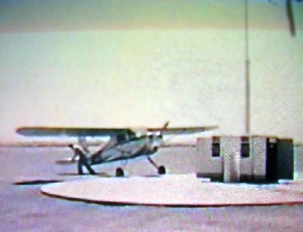
A 1947 photo (enhanced by Bill Grasha) of a Cessna 1940 at the Shell gas island at La Cresta Airport.
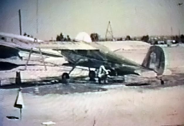
A 1947 photo (enhanced by Bill Grasha) of a Cessna 1940 undergoing maintenance at La Cresta Airport.
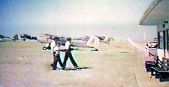
A 1947 photo (enhanced by Bill Grasha) of several people walking into the La Cresta Airport office, with several aircraft in the background.
Mary Shell recalled, "Small-plane owners kept their aircraft at the field, and it was a base of operations for Atwood Crop Dusters,
which was the largest crop dusting firm here at the time.
Most of the Atwood pilots were WWII veterans just out of the service.
One was Jim French, a Navy ace, and another was Steve Straub, an American who volunteered with the Royal Canadian Air Force before we were in the war.
Steve flew Spitfires. Another Canadian pilot for Atwood was Bill Jukes.
I worked there in 1947/48 in the office, keeping books & dispatching planes.
I had obtained my private pilot's license in 1947, and I received part of my pay at La Cresta Airfield in flying time.
I remember Johnnie Bresnahan & his PT-19 & Jim Bowers & Hal Reed & their BT-13. Cliff Purple was the mechanic there.”
A 1949 aerial view of the northwest end of La Cresta Airport.
According to Gilbert Gia, "In 1949 Monte Montijo was in charge of La Cresta Squadron of the Civil Air Patrol at La Cresta Airport.
Monte was an early leader in Civil Air Patrol.”
La Cresta Airport was not depicted at all on USGS topo maps from the 1940s-50s.
The only aeronautical chart depiction which has been located of La Cresta Airport was on the September 1950 LA Sectional Chart.
It depicted La Cresta Airport as having a 3,400' unpaved runway.
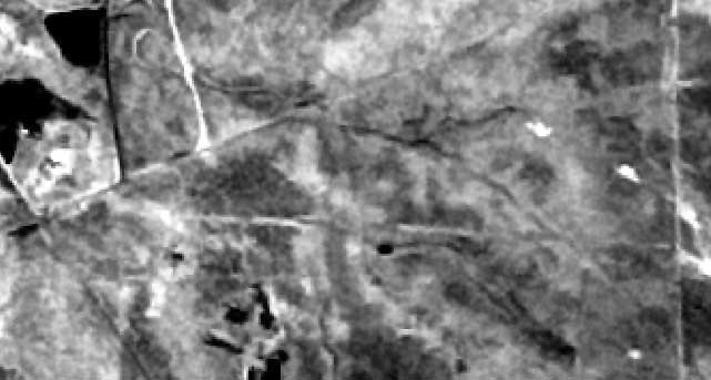
The last photo which has been located of La Cresta Airport was an 8/15/52 USGS aerial view.
Although a single unpaved northwest/southwest runway was still present,
the field appeared abandoned already, with no aircraft visible on the field, and it appears the airport buildings had been removed.
According to Gilbert Gia, "Panorama drive was widened in 1954 & Mt. Vernon avenue extended north to Columbus Avenue.
But the continued noise, accidents, and nearby construction of Bakersfield College closed La Cresta Airfield.
Homes were built on the old runway; the airstrip disappeared.”
La Cresta Airport was no longer depicted on the March 1955 LA Sectional Chart.
A 1992 aerial photo showed the site covered with housing, with not a trace remaining of La Cresta Airport.
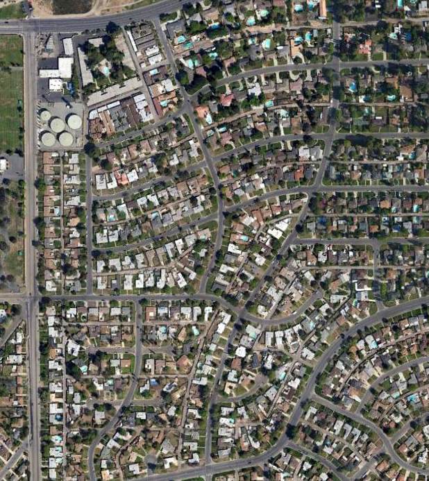
A 3/28/13 showed no trace remaining of La Cresta Airport.
____________________________________________________
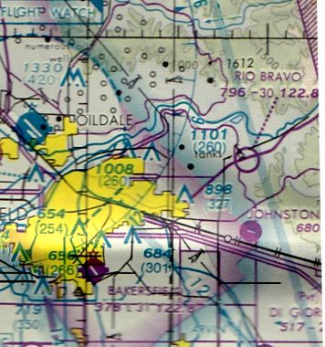
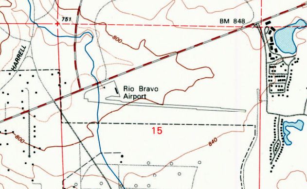
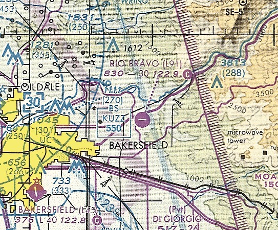
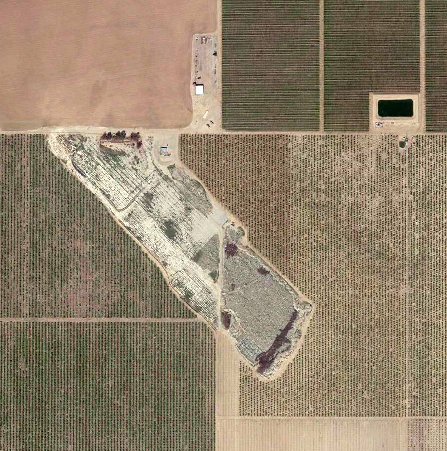
Rio Bravo Airport, East Bakersfield, CA
35.407, -118.853 (Northeast of Bakersfield, CA)
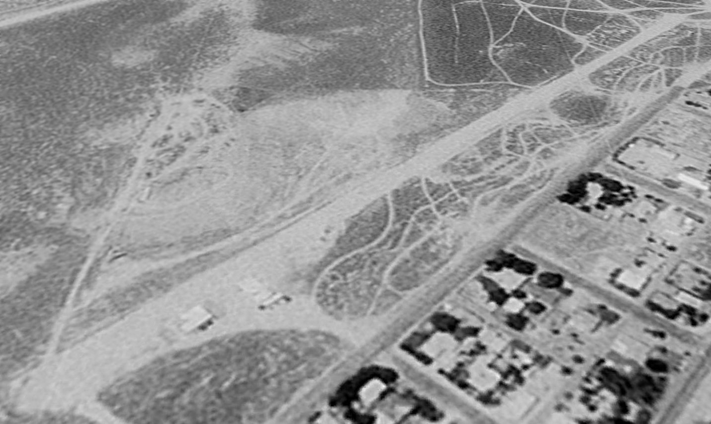
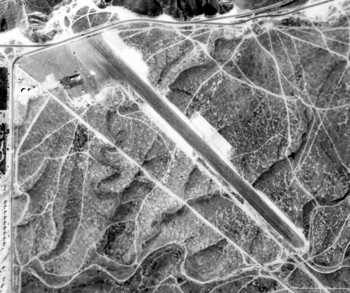
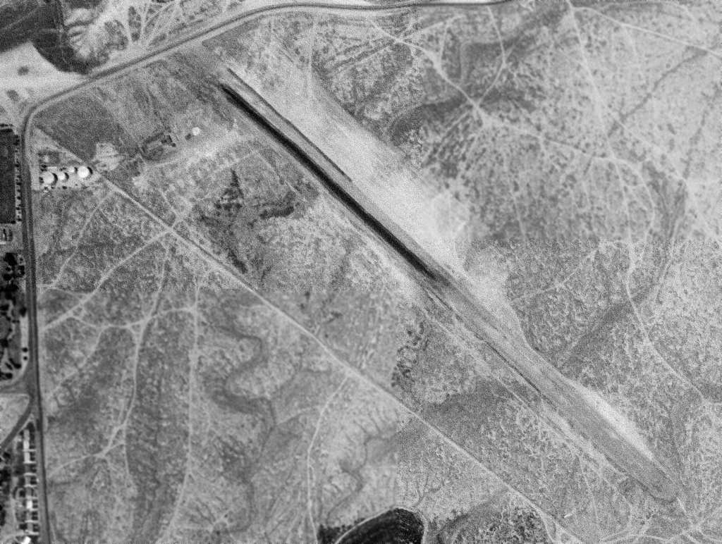
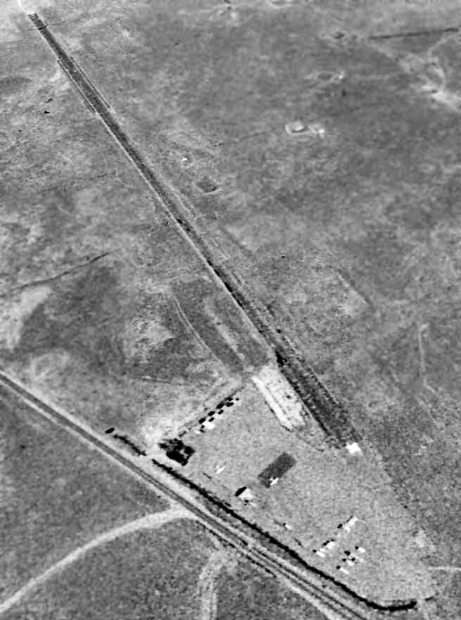
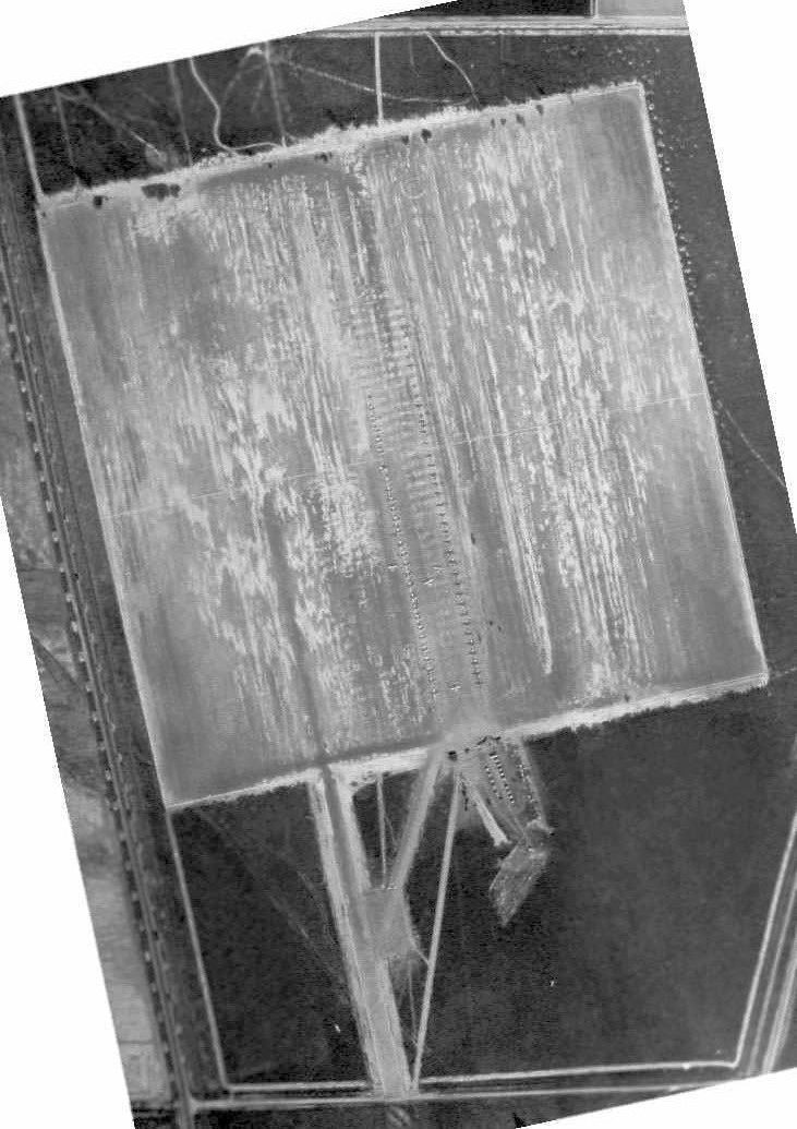
The earliest depiction which has been located of Rio Bravo Airport was an admittedly low-resolution 9/29/78 USGS aerial view (courtesy of Dallam Oliver-Lee).
Rio Bravo Airport was yet another small grassroots general aviation airport lost to our nation's unquenchable need to build ever-more houses.
This small general aviation airport on the east side of Bakersfield was not yet depicted on a 6/4/77 USGS aerial photo (courtesy of Dallam Oliver-Lee).
According to Charles Jones, “Rio Bravo Airport...was built in late summer of 1978.
I grew up in East Bakersfield & still live in the area about 2 miles from the site of that strip.
As far as I know it wasn't around when I & friends visited the Kern River in July of that year.”
The earliest depiction which has been located of Rio Bravo Airport was a 9/29/78 USGS aerial view (courtesy of Dallam Oliver-Lee).
It depicted the field as having a single east/west runway.
The earliest aeronautical chart depiction which has been located of Rio Bravo Airport
was on the January 1982 LA Sectional Chart (courtesy of Paul Columbus).
It depicted Rio Bravo as having a 3,000' unpaved runway.
According to Charles Jones, “In 1984 I was working for Beechcraft West at Meadows Field as a line rat when a van pulled up & several men got out.
My manager asked if I knew how to get to Rio Bravo & if so I was to take these men there.
It turned out that they were repossession agents & they were planning to recover a Mitsubishi Diamond biz jet that had been flown into that field.
When we arrived they gave the bird a quick look over noting that the torque link for the nose mount & the battery had been removed by the guy that had leased the plane.
I was asked to distract the girl that manned the office at this airfield as I mentioned that I knew her from school.
When I walked into the office she was just picking up the phone, I later found out that she was trying to call the pilot of the Diamond
but I managed to flirt with her & otherwise kept her from calling until she asked me what was going on.
I told her the truth, that the Diamond was being repossessed & warning the pilot would be a bad idea.
These guys had been chasing this aircraft for at least 3 months by then & every time the pilot was tipped off before they could get it into the air.”
Charles continued, “The agents got the plane flight ready & then realized that the runway was possibly a little too short,
especially as it was in the middle of summer & the temperature was in the high 90s to low 100s.
It was decided to try & launch from the very end of the approach end,
actually the aircraft was in the dirt & about 10' from the oleander bushes that lined the airport property alongside Kern Canyon Road.
Before the takeoff I was asked to chase the Diamond in case it ran out of runway before they got into the air.
I had a couple of these guys still in the van as to not make the plane any heavier than it need to be
so should something go wrong there were enough people outside that could help the others out to safety.
I was a member of the USS Saratoga's flight deck crew & had been trained to help with crashes & rescues so while the equipment on hand was slight at least we could make some sort of difference.”
Charles continued, “Needless to say the Diamond got airborne with almost the whole runway.
The one thing I think that helped was the topography of the facility.
In the aerial pictures the runway appears flat; in reality it was sloped from the west end to about the middle & that was the direction the plane took, west to east, downhill.
When I took the guys with me back to Meadows to meet up with their friends the pilot told us that he flew low orbits over the 2 resort areas in the area
so that whoever had leased the aircraft would know that Mitsubishi once again had it.
As a point of closure as I was helping fuel the Diamond & getting ready to send it on it's way
the Kern County Sheriff's office sent a deputy out to question everyone about a reported 'theft' of a biz jet.
Fortunately it was another old classmate that asked a few questions & left after he talked to me.
You have to understand that until the mid- to late-1980s Bakersfield was still a relatively small town where it was more like 4 degrees of separation instead of the typical 6 between people.”
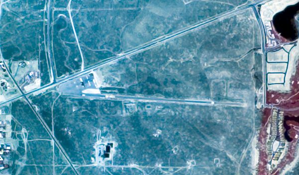
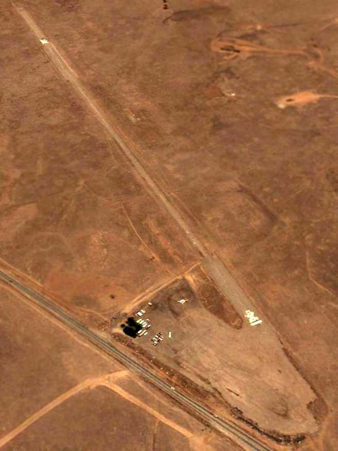
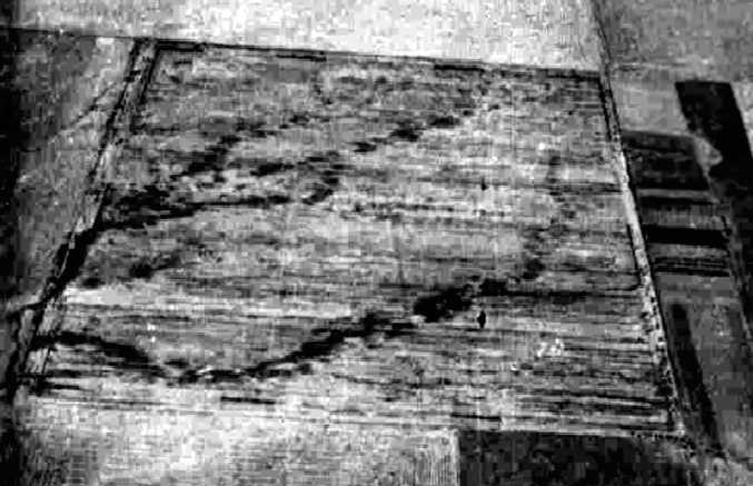
A 7/17/89 aerial view (from the UCSB Library) depicted Rio Bravo as having a single paved east/west runway.
The 1992 USGS topo map depicted Rio Bravo Airport as having a single east/west runway,
with a ramp & 2 small buildings on the northwest side.
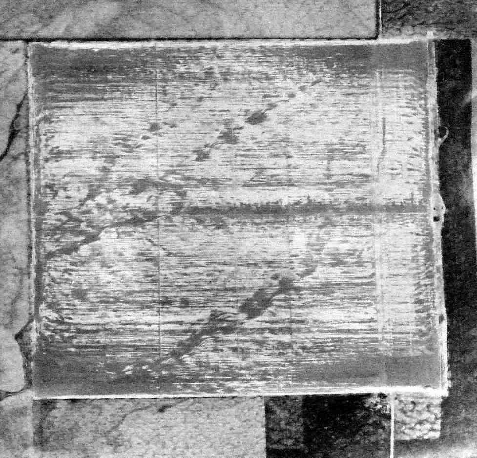
The last photo which has been located showing Rio Bravo Airport still having aircraft present
was a 9/15/92 USGS aerial view looking southeast (courtesy of Dallam Oliver-Lee).
It depicted 2 single-engine aircraft on the ramp on the northwest side, even though the runway was already marked with a closed “X” on each end.
The last aeronautical chart depiction which has been located of Rio Bravo Airport
was on the January 1998 LA Sectional Chart (courtesy of Ron Plante).
It depicted Rio Bravo as having a 3,000' paved east/west runway.
Rio Bravo Airport was evidently closed at some point between 1998-2002,
as a 5/5/02 USGS aerial view (courtesy of Dallam Oliver-Lee) depicted closed-runway “X” symbols having been painted on each end of the runway,
and several of the T-hangars had been removed.
According to Charles Jones, “It's the new homeowners that I believe got the field closed down.”
The last photo which has been located showing Rio Bravo Airport still remaining mostly intact
was a 9/9/02 USGS aerial view looking southeast (courtesy of Dallam Oliver-Lee).
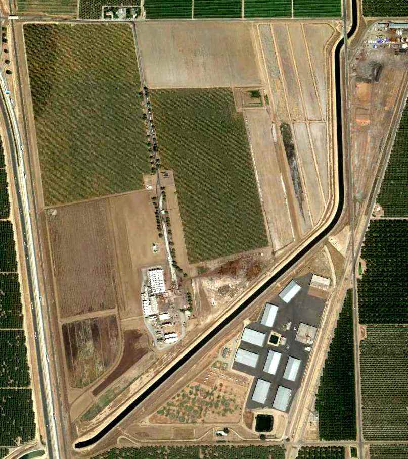
A 12/31/04 USGS aerial view (courtesy of Dallam Oliver-Lee) showed that construction for new houses had covered the airport property.
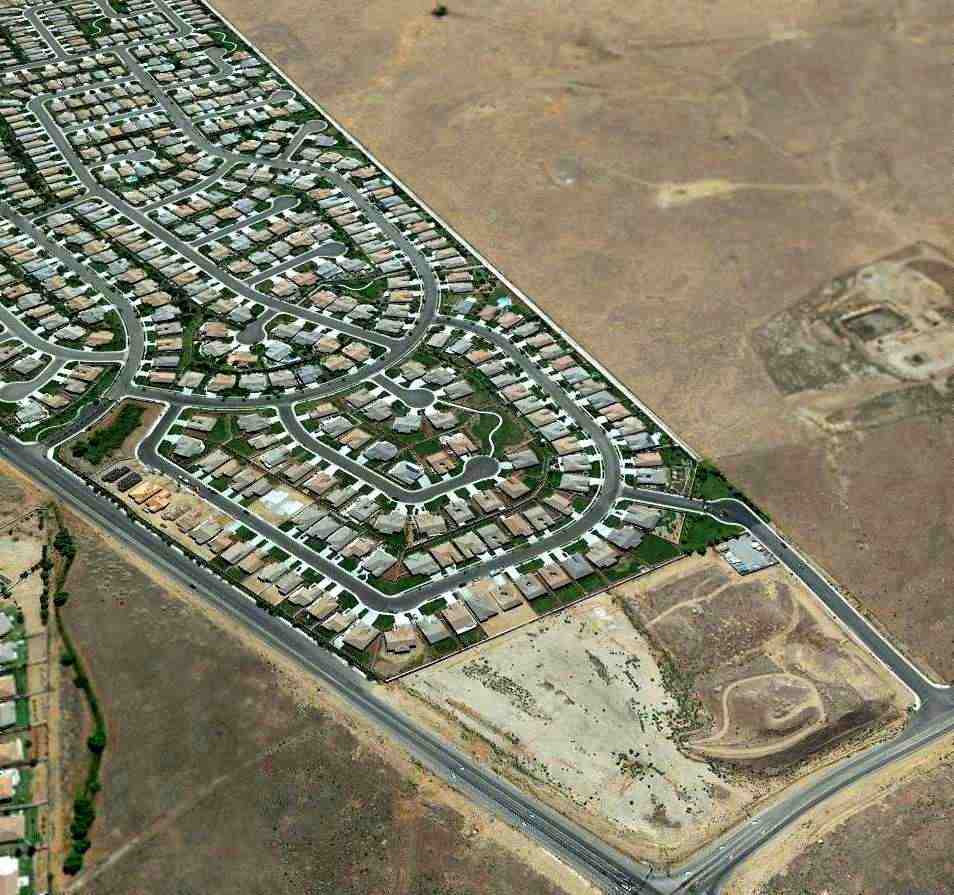
An 8/7/12 aerial photo appeared to show all of Rio Bravo Airport covered by a new housing development.
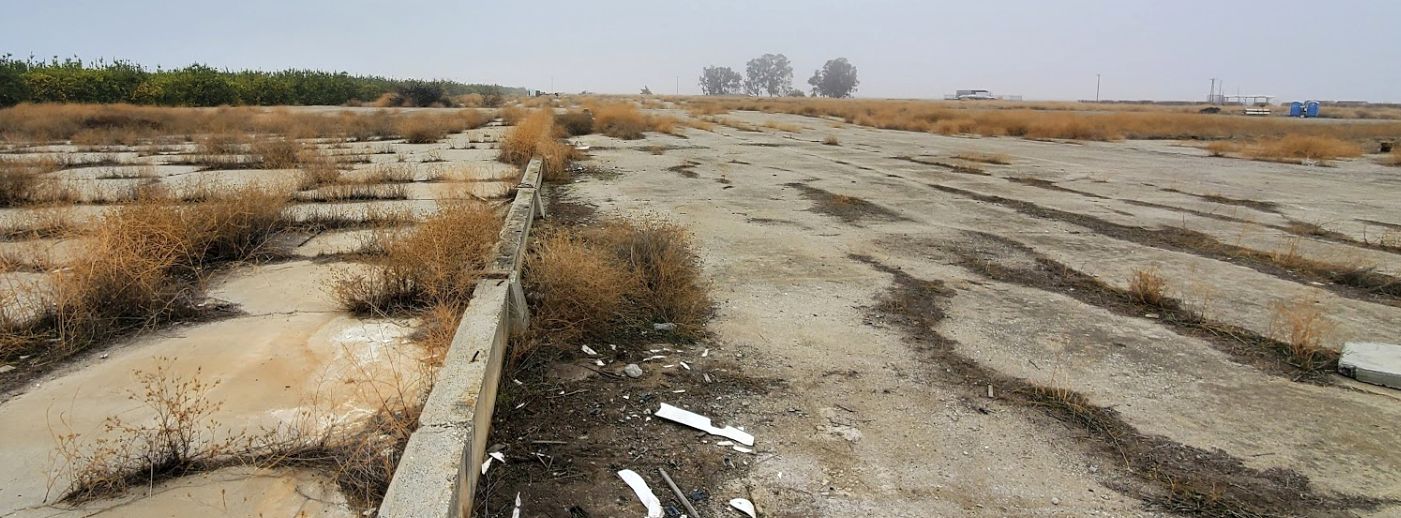
However, an eagle-eyed Keith Wood pointed out, “The runway markings are visible at the near end of the housing tract, just outside the fence in the clear ground.”
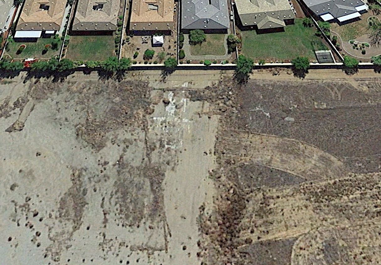
A 2021 aerial view looking east at the west side of the Rio Bravo Airport site showed the former runway markings remain visible just outside the edge of the housing tract.
The site of Rio Bravo Airport is located south of the intersection of Kern Canyon Road & Park Palisade Drive.
____________________________________________________
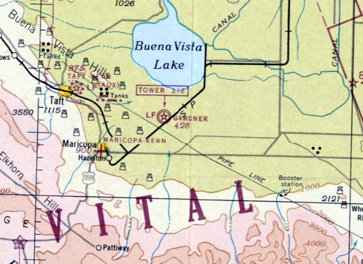
Minter Auxiliary Army Airfield A-2 / Pond Field, Pond, CA
35.71, -119.35 (Northwest of Bakersfield, CA)
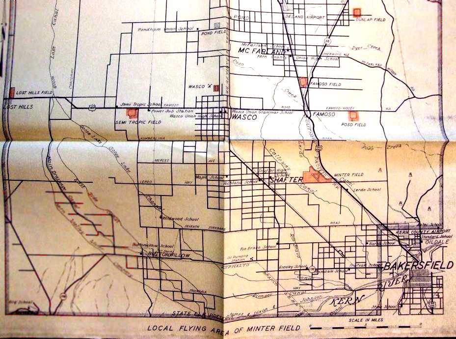
Pond Field, as depicted on a 1944 “Local flying area of Minter Field” map (courtesy of Ron Plante), along with the other Minter Auxiliary Fields.
Photo of the airfield while in use has not been located.
Minter Auxiliary Army Airfield A-2 / Pond Field was one of 8 satellite airfields which supported WW2 military flight training at Lerdo Field / Minter AAF,
which was located a few miles to the southeast.
The date of construction of Pond Field has not been determined,
but its parent Lerdo Field was opened in June 1941.
Pond Field was not depicted on 1942/44/45 LA Sectional Charts.
Throughout WW2, the primary aircraft flown at Minter Field was the Vultee BT-13 Valiant, which was used for basic flight training.
Other training aircraft included the Cessna UC-78 Bobcat, as well as the AT-6 Texan advanced trainer,
North American B-25 Mitchell twin-engine medium bomber, and Lockheed P-38 Lightning fighter.
Stewart Smith of the 525th School Squadron was killed in a stall/spin accident 6 NM west of Pond Field on 8/12/42.
The earliest depiction which has been located of Pond Field
was on a “Local flying area of Minter Field” map (courtesy of Ron Plante), along with the other Minter Auxiliary Fields.

Pond Field was no longer depicted on the February 1944 Sectional Chart (courtesy of Ron Plante),
but its location was hand-drawn along with the other Minter Auxiliary Fields.
An AT-17B twin-engine trainer had a forced landing due to engine failure 7 NM west of Pond Field on 6/24/44,
serial # 42-38889, piloted by Neal Wiedenmann.
Pond Field was not listed (unlike the other Minter Auxiliary Airfields) in the 1945 AAF Airfield Directory (courtesy of Scott Murdock),
so it may have been abandoned at an earlier date.
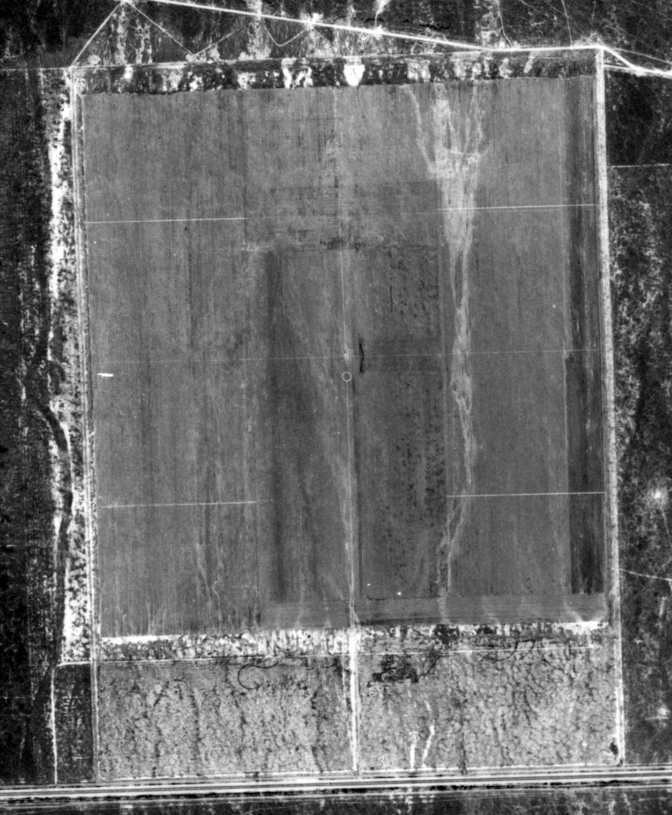
The only photo which has been located of Pond Field was a 7/7/46 aerial view (from the UCSB Library).
It depicted Pond Field as having 5 oiled runways occupying a square property.
There were no buildings on the site.
Pond Field was no longer depicted at all on the 1953 USGS topo map.
By the time of the 1994 USGS aerial photo the location of the airfield had been taken over for farming,
and no trace was recognizable of the former airfield.
An 8/27/12 aerial photo did not show any trace remaining of the former Pond Field.
The site of Pond Field is located northeast of the intersection of Peterson Road & Magnolia Avenue.
____________________________________________________
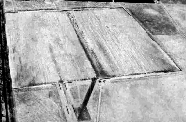
Minter Auxiliary Army Airfield A-3 / Famoso Field, Wasco, CA
35.64, -119.21 (Northwest of Bakersfield, CA)
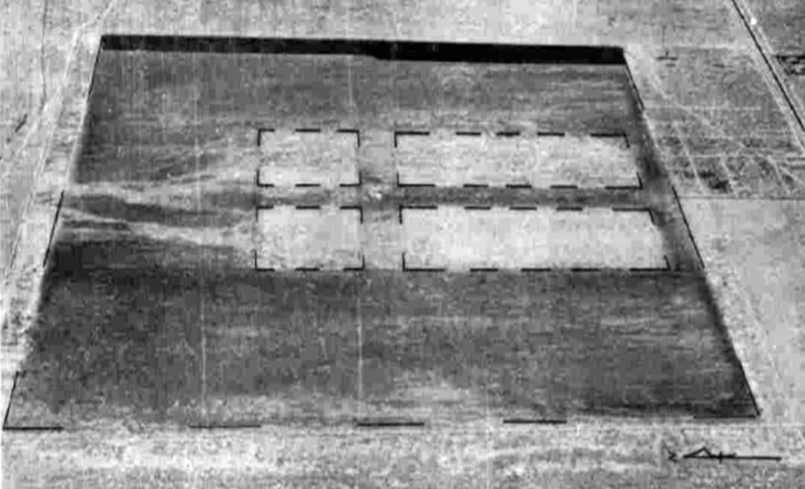
A 7/22/43 aerial view looking north at “Minter Field Auxiliary #3 (Famoso Field)”
from the 1945 AAF Airfield Directory (courtesy of Scott Murdock).
Minter Auxiliary Army Airfield A-3 / Famoso Field was one of 8 satellite airfields which supported WW2 military flight training at Lerdo Field / Minter AAF,
which was located a mere 3 NM to the south.
The date of construction of Famoso Field has not been determined, but its parent Lerdo Field was opened in June 1941.
Famoso Field was not depicted on 1942/44/45 LA Sectional Charts.
Throughout WW2, the primary aircraft flown at Minter Field was the Vultee BT-13 Valiant, which was used for basic flight training.
Other training aircraft included the Cessna UC-78 Bobcat, as well as the AT-6 Texan advanced trainer,
North American B-25 Mitchell twin-engine medium bomber, and Lockheed P-38 Lightning fighter.
A BT-13 trainer had an accident at Famoso Field on 4/22/42, serial # 41-10699, piloted by Leroy McDonald.
The earliest depiction which has been located of Famoso Field was a 7/22/43 aerial view looking north
from the 1945 AAF Airfield Directory (courtesy of Scott Murdock).
It depicted “Minter Field Auxiliary #3 (Famoso Field)” as having a square paved landing mat.
Famoso Field, as depicted on a 1944 “Local flying area of Minter Field” map (courtesy of Ron Plante), along with the other Minter Auxiliary Fields.
The location of “Famoso Aux Fd” was hand-drawn over a February 1944 Sectional Chart (courtesy of Ron Plante), along with the other Minter Auxiliary Fields.
The only photo which has been located showing Famoso Field in operational was a 1944 aerial view (courtesy of Ron Plante, enhanced by Bill Grasha),
showing 4 single-engine aircraft operating along a strip which had been marked along the center of the landing mat.
The 1945 AAF Airfield Directory (courtesy of Scott Murdock) described “Minter Field Auxiliary #3 (Famoso Field)”
as having a 3,000' square road-mix landing mat with a 1,570' extension on the southeast end.
It was described as being owned by private interests but operated by the Army Air Forces, but to be “inactive”.
An AT-6C trainer had an accident at Famoso Field on 7/16/45, serial # 42-44187, piloted by Vincent Cunniff.
The date of closure of Famoso Field has not been determined,
but operations at its parent field (Minter AAF) ceased with the end of WW2 in 1945.
Famoso Field was no longer depicted at all on the 1953 USGS topo map.
By the time of the 1994 USGS aerial photo the location of Famoso Field had been taken over for farming,
and no trace was recognizable of the former airfield.
An 8/27/12 aerial photo did not show any trace remaining of the former Famoso Field.
The site of Famoso Field is located southeast of the intersection of Route 99 & Whisler Road.
____________________________________________________
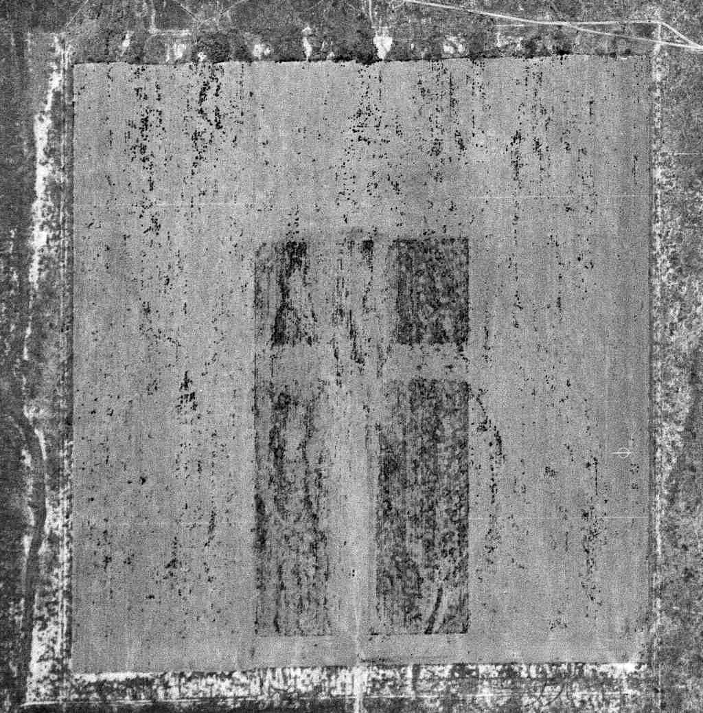
Minter Auxiliary Army Airfield A-4 / Dunlap Field / Jasmin Landing Field, Richgrove, CA
35.737, -119.122 (Northwest of Bakersfield, CA)
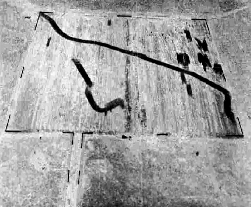
A 7/22/43 aerial view looking north at “Minter Field Auxiliary #4 (Dunlap Field)”
from the 1945 AAF Airfield Directory (courtesy of Scott Murdock).
Minter Auxiliary Army Airfield A-4 / Dunlap Field was one of 8 satellite airfields
which supported WW2 military flight training at Lerdo Field / Minter AAF,
which was located a mere 3 NM to the south.
The date of construction of Dunlap Field has not been determined,
but its parent Lerdo Field was opened in June 1941.
Dunlap Field was not depicted on 1942/44/45 LA Sectional Charts.
Throughout WW2, the primary aircraft flown at Minter Field was the Vultee BT-13 Valiant, which was used for basic flight training.
Other training aircraft included the Cessna UC-78 Bobcat, as well as the AT-6 Texan advanced trainer,
North American B-25 Mitchell twin-engine medium bomber, and Lockheed P-38 Lightning fighter.
A BT-13 trainer had an accident at Dunlap Field on 4/8/42, serial # 41-9665, piloted by William Raabe.
The earliest depiction which has been located of Dunlap Field was a 7/22/43 aerial view looking north
from the 1945 AAF Airfield Directory (courtesy of Scott Murdock).
It depicted “Minter Field Auxiliary #4 (Dunlap Field)” as having a square paved landing mat.
The location of “Dunlap Aux Fd” was hand-drawn over a February 1944 Sectional Chart (courtesy of Ron Plante), along with the other Minter Auxiliary Fields.
“Dunlap Field”, as denoted on a “Local flying area of Minter Field” map (courtesy of Ron Plante), along with the other Minter Auxiliary Fields.
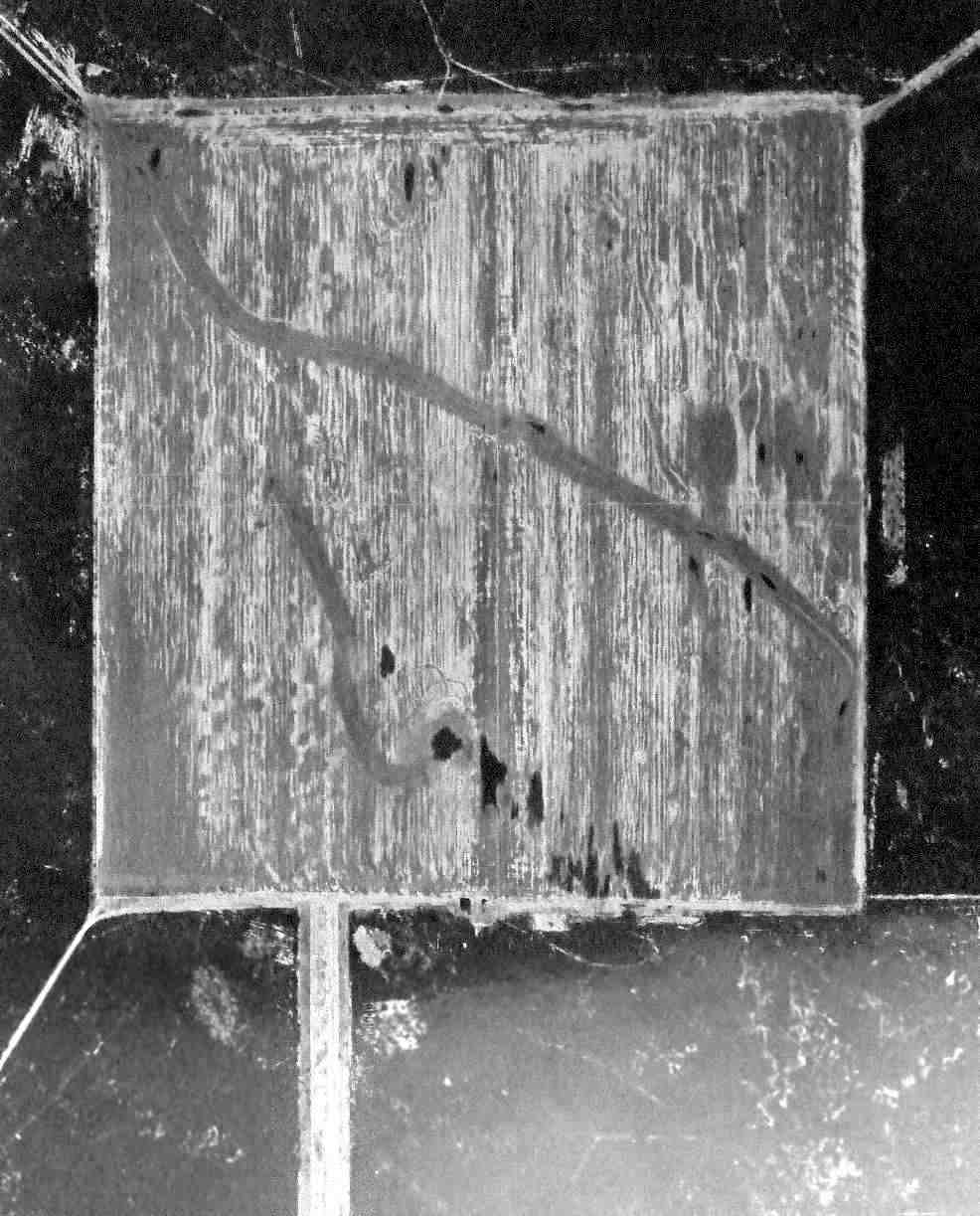
A 1944 aerial view (courtesy of Ron Plante) depicted Dunlap Field as a square landing mat.
The 1945 AAF Airfield Directory (courtesy of Scott Murdock) described “Minter Field Auxiliary #4 (Dunlap Field)”
as a 200 acre square field within which was a 2,640' square road-mix landing mat.
The field was said to not have any hangars.
It was described as being owned by private interests but operated by the Army Air Forces, but to be “inactive”.
An AT-6C trainer had an accident at Dunlap Field on 7/23/45, serial # 42-3911, piloted by Kay Nelson.
The date of closure of Dunlap Field has not been determined,
but operations at its parent field (Minter AAF) ceased with the end of WW2 in 1945.
Dunlap Field was no longer depicted at all on the 1949 Los Angeles Sectional Chart (according to Chris Kennedy)
or the 1953 USGS topo map.
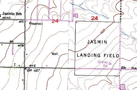
An airfield labeled “Jasmin Landing Field” was still depicted on the 1991 USGS topo map at the same location,
so this field may have been reused in the postwar period for civil aviation.
By the time of the 1994 USGS aerial photo the location of Jasmin Field had been taken over for farming,
and no trace was recognizable of the former airfield.
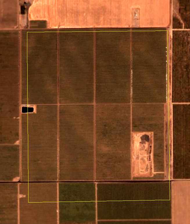
The outline of Dunlap Field, as annotated by Chris Kennedy over a 2006 aerial view.
No trace of the airfield appears to remain.
The site of Dunlap Field is located northwest of the intersection of Hart Avenue & Quality Road.
____________________________________________________
Minter Auxiliary Army Airfield A-5 / Semi-Tropic Field, Wasco, CA
35.6, -119.48 (Northwest of Bakersfield, CA)
A 7/22/43 aerial view looking north at “Minter Field Auxiliary #5 (Semi-Tropic Field)”
from the 1945 AAF Airfield Directory (courtesy of Scott Murdock).
Minter Auxiliary Army Airfield A-5 / Semi-Tropic Field was one of 8 satellite airfields which supported WW2 military flight training at Lerdo Field / Minter AAF,
which was located 7 NM to the southeast.
The date of construction of Semi-Tropic Field has not been determined,
but its parent Lerdo Field was opened in June 1941.
Semi-Tropic Field was not depicted on 1942/44/45 LA Sectional Charts.
Throughout WW2, the primary aircraft flown at Minter Field was the Vultee BT-13 Valiant, which was used for basic flight training.
Other training aircraft included the Cessna UC-78 Bobcat, as well as the AT-6 Texan advanced trainer,
North American B-25 Mitchell twin-engine medium bomber, and Lockheed P-38 Lightning fighter.
The earliest depiction which has been located of Semi-Tropic Field was a 7/22/43 aerial view looking north
from the 1945 AAF Airfield Directory (courtesy of Scott Murdock).
It depicted “Minter Field Auxiliary #5 (Semi-Tropic Field)” as having a square paved landing mat, with an extension on the south side.
Otto Piepnbrink was killed in a crash of a BT-13A trainer of the 324th Basic Flight Training Squadron on 10/24/43, 1 mile north of Semi-Tropic Field.
The location of “Semi-Tropic Aux Fd” was hand-drawn over a February 1944 Sectional Chart (courtesy of Ron Plante), along with the other Minter Auxiliary Fields.
“Semi-Tropic Field”, as denoted on a “Local flying area of Minter Field” map (courtesy of Ron Plante), along with the other Minter Auxiliary Fields.
A 1944 aerial view (courtesy of Ron Plante) depicted Semi-Tropic Field as having a square paved landing mat, with an extension on the south side.
Leroy Carpenter bailed out of a BT-13A trainer of the 324th Basic Flight Training Squadron on 3/10/44, 2 miles west of Semi-Tropic Field.
The 1945 AAF Airfield Directory (courtesy of Scott Murdock) described “Minter Field Auxiliary #5 (Semi-Tropic Field)”
as a 600 acre irregularly-shaped property having a 3,000' square road-mix landing mat with a 1,384' extension on the south side.
It was described as being owned by private interests but operated by the Army Air Forces, but to be “inactive”.
The date of closure of Semi-Tropic Field has not been determined,
but operations at its parent field (Minter AAF) ceased with the end of WW2 in 1945.
Semi-Tropic Field was no longer depicted at all on the 1953 USGS topo map.
By the time of the 1994 USGS aerial photo the location of Semi-Tropic Field had been taken over for farming,
and no trace was recognizable of the former airfield.
An 8/27/12 aerial photo did not show any trace remaining of the former Semi-Tropic Field.
The site of Semi-Tropic Field is located southwest of the intersection of Route 46 & Rowlee Road.
____________________________________________________
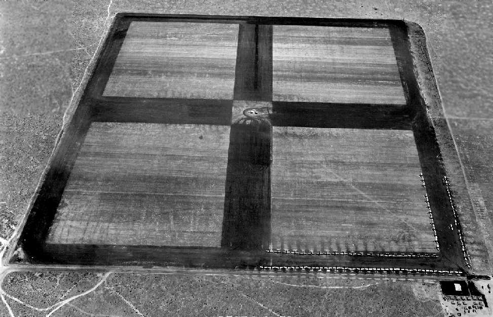
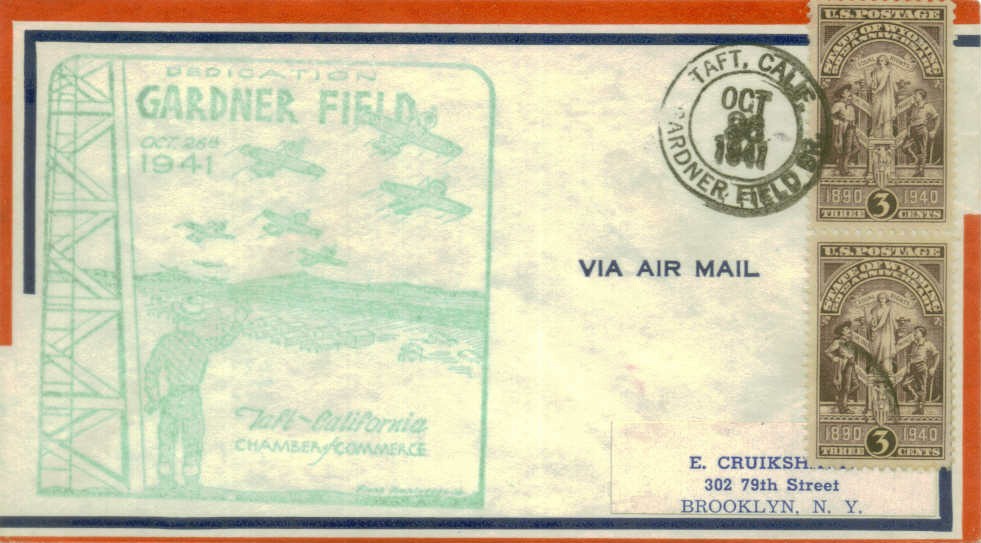
Gardner Army Airfield / Gardner Airport, Taft, CA
35.11, -119.303 (Northwest of Los Angeles, CA)
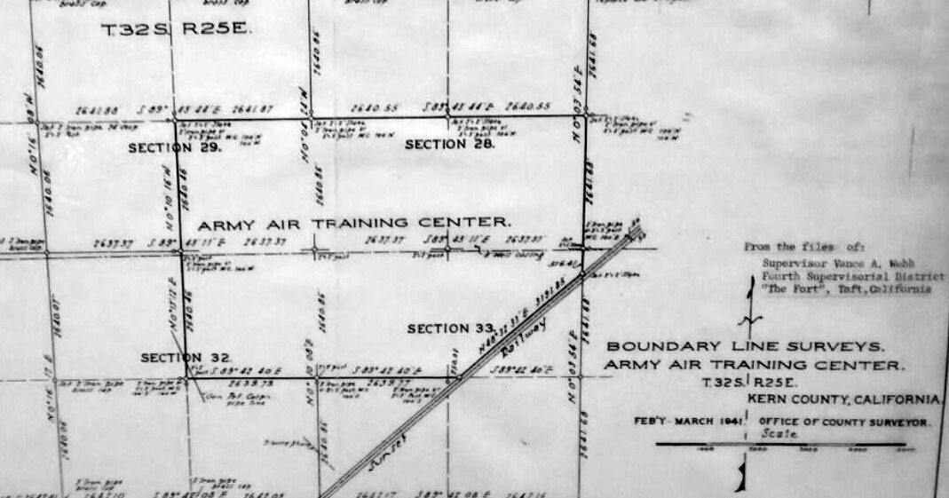
A February-March 1941 Kern County plat of Boundary Line Surveys of the Gardner Field Army Air Training Center (from the Taft Oil Museum, courtesy of Rex Ricks).
This WW2-era Army Airfield was authorized in 1940.
The earliest depiction which has been located of Gardner Field was a February-March 1941 Kern County plat
of Boundary Line Surveys of the “Army Air Training Center” (from the Taft Oil Museum, courtesy of Rex Ricks).
Gardner Field was active by 1941.
According to the "Bee Tee", a publication by the Aviation Cadets of Class 42-D, Gardner Field, Volume 1, #1, February, 1942 (courtesy of Pat Thomas),
the first commander of the field was Major K. C. McGregor.
According to a historical plaque at the site, Gardner Field consisted of a total of 985 acres, and was named in honor of Major John Gardner.
According to Brian Rehwinkel, an 8/11/41 USAAF aerial view shows the Gardner AAF runways under construction.
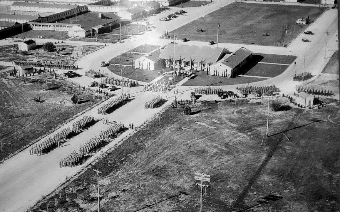
Fifty eager cadets comprised the first class (41-H) to arrive at Gardner.
What a surprise awaited them - no quarters, no field, no planes.
After an anxious week of anticipation, planes began roaring in. Tents provided the initial accommodations.
Eventually, with 2,000 Air Corps personnel in residence,
the base had its own hospital, 40-acre sewage plant, 9 administration buildings,
4 mess halls, supply rooms, officers' quarters, a guardhouse, a chapel, 37 barracks and a landing field.
There was even a swimming pool paid for by Hollywood celebrities such as Joel McCrea,
who enjoyed driving up to Taft & hanging out with the hotshot pilots.
Swimming star Johnny Weissmuller enlivened the pool's dedication with his Tarzan jungle call.
It was an event that not only remolded Taft's economy for the duration of the war -
it also permanently altered the town's social fabric.
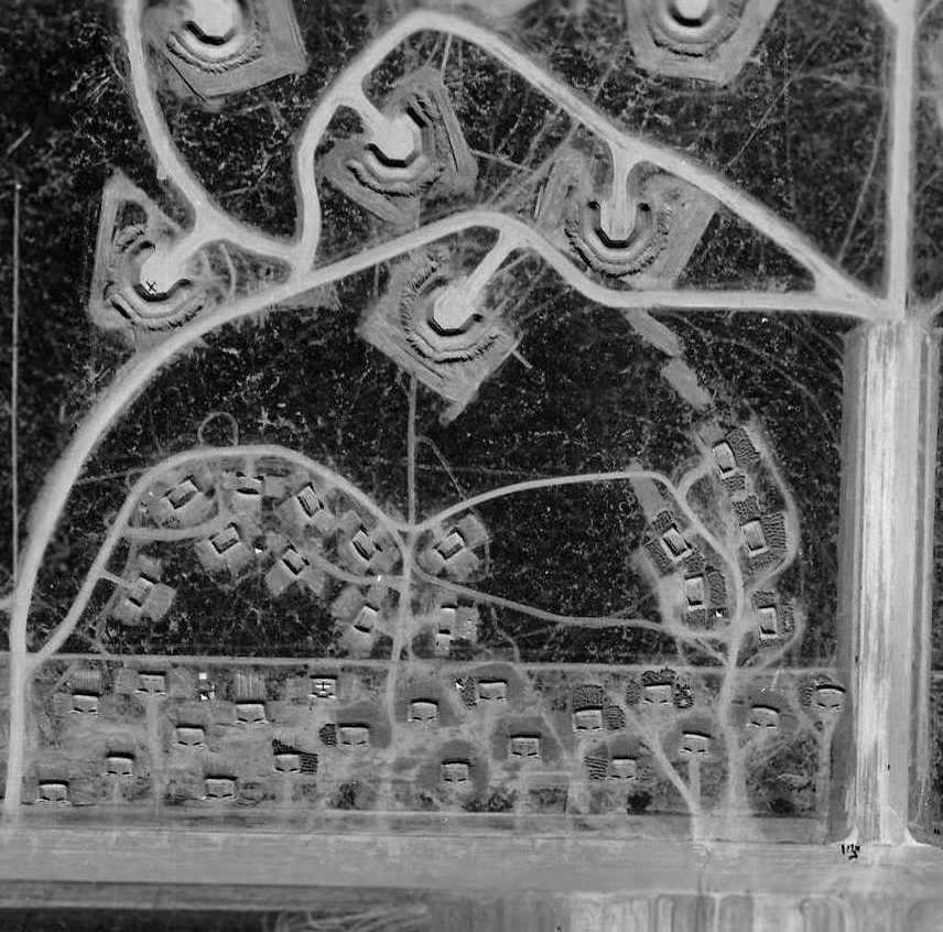
The earliest depiction which has been located of Gardner AAF was a 1/20/42 USAAF aerial view (from the National Archives, via Brian Rehwinkel).
It depicted Gardner AAF as having 3 paved runways, paved taxiways, a large concrete ramp, 2 hangars,
and a large number of temporary buildings on the southwest side of the installation.
Interestingly, the photo depicted 17 large earthen aircraft parking revetments on the east & north sides of the airfield,
along with a much larger number of smaller revetments on the north & southwest sides of the field.
Brian Rehwinkel observed of the revetments, “I am guessing these were hastily constructed after Pear Harbor.
Especially given the fact the photo was taken less than 2 months after the attack.
I don’t know for sure, but I am guessing that because this was a west coast field (even a training field)
the revetments were built as a reaction to the fear of attack.
I noticed that only a couple off planes were actually using the revetments,
so I wonder if this was an example of following orders -
even though the base commander really didn’t expect to be attacked.”
A closeup of the 1/20/42 USAAF aerial view (from the National Archives, via Brian Rehwinkel),
showing 2 aircraft parked within the revetments on the north side of Gardner AAF.
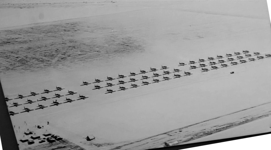
A closeup of the 1/20/42 USAAF aerial view (from the National Archives, via Brian Rehwinkel)
showing over 60 single-engine aircraft on the Gardner ramp.
A closeup of the 1/20/42 USAAF aerial view (from the National Archives, via Brian Rehwinkel),
showing 3 aircraft making a formation takeoff along with a 4th aircraft somewhat behind them.
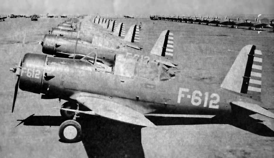
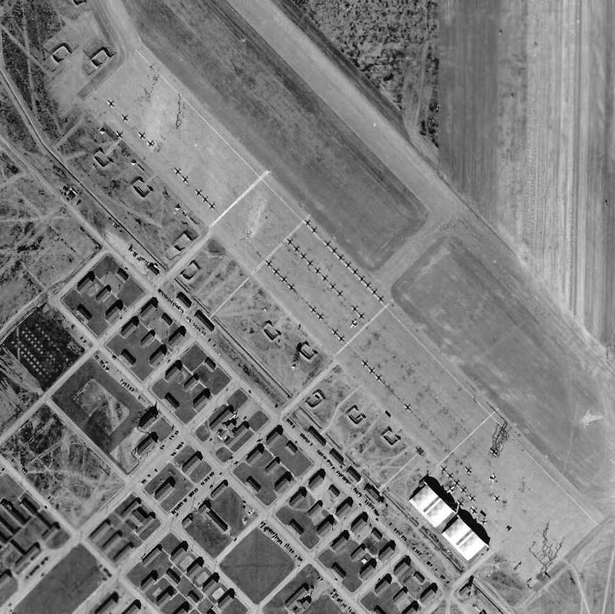
Rows of Vultee BT-13 trainers at Gardner, from the back cover of the February 1942 Gardner "BeeTee"
(courtesy of Pat Thomas, whose father, Howard R. McCullough, was a flight instructor during WW2).
Gardner Field was not yet depicted on the April 1942 LA Sectional Chart.
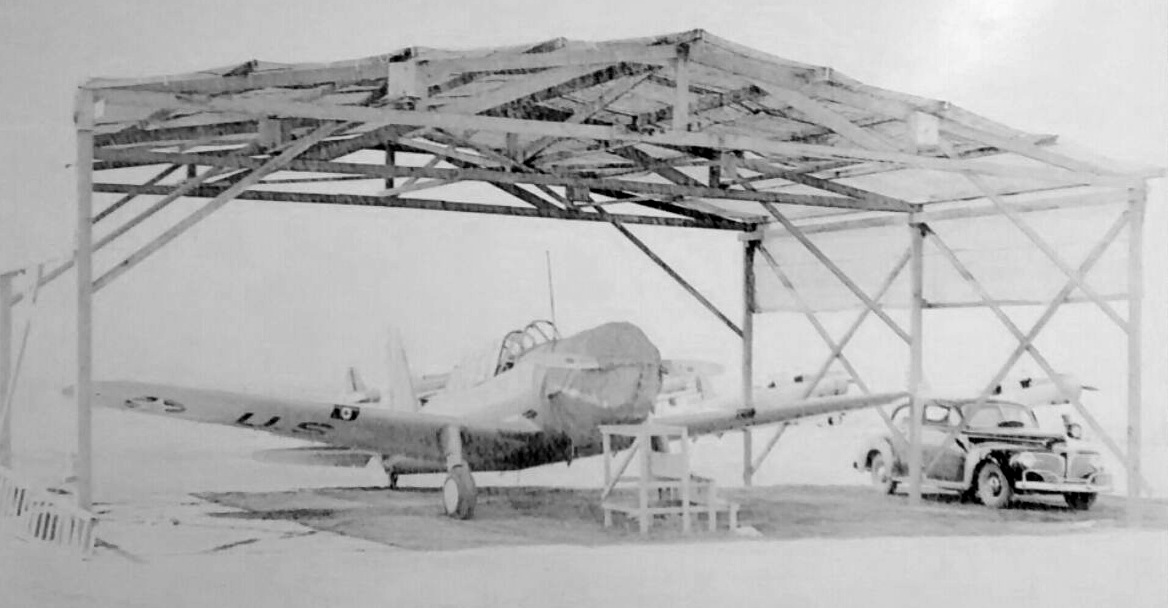
An undated photo of a under a sunshade at Gardner Field (from the Taft Oil Museum, courtesy of Rex Ricks).
An undated aerial view of dozens of trainers on the Gardner Field ramp (from the Taft Oil Museum, courtesy of Rex Ricks).
Mark Milliken reported, “One friend was born & raised in Taft, and his father worked as an aircraft mechanic at Gardner Field.
One night, the father came home & reported that 12 B-25s had landed at Gardner.
They were to remove & replace all wiring throughout each aircraft, for what reason he had no idea. Everything was hush-hush.
After the Doolittle raid [4/18/42], his father was sure those planes were the same B-25s that had the electrical overhauls at Gardner field.
He said the overhauls were done to ensure against sabotage.”
A letter from James Ashton (courtesy of Peter Ashton) described his training at Gardner:
“I have my gas mask on as I write this letter. It is kind of awkward & uncomfortable, but it is part of our training to wear the dawgone things.
Yes Dad, we are all flying BT-13s. These are 450 horsepower low-wing trainers.
They are a pretty good-sized airplane completely equipped for instrument & night flying.
We fly 5 days a week, Tuesday-Thursday. On Saturday we get open post about 6pm which last until 9:30pm.
Sunday-Monday is day of Inspection, lectures, drill, etc. The daily schedule is very tight, we are on the move all the time.
Bed time is 9:30 & you go to then whether you want to or not. Reville is 5:30.
We fly 1/2 of the day & go to ground school & PT the other half. Each day we alternate between morning & afternoon flying.
The morning is usually better as the air is smooth, and your fresh, ready to go. The BT is a swell airplane to fly, I sure like it.
From all indications however, the going will be very rough here, so I'll really have to stay on the ball not to be washed out.
It gets tougher as the need for pilots diminishes.
One of the different aspects of flying this airplane is that it somewhat more complicated to operate than my ship I have flown in
that it had prop pitch, flaps, mixture control, radio-two way etc.
Consequently procedures are very important & must be memorized and followed exactly.”
Former aircraft mechanic Yeager arrived at Gardner in July 1942 after being enrolled in pilot training in Hemet,
where he reported experiencing "queasiness" the first couple of times he went up.
Taft Auxiliary Airfield #2 was initially used to support Gardner Field flight training operations.
The Post Headquarters building was the first to be completed at Gardner Field.
There were 2 flights within Class 41-H, "K" & "T".
In the "K" Flight, there were no washouts & no serious damage was done to any ships used by that flight.
They flew off an auxiliary field, itself hardly completed. An ambulance always stood by for emergencies.
Gardner operated BT-13 & PT-17 aircraft for primary training.
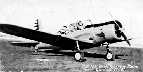
An undated photo of a Vultee BT-13 trainer at Gardner (courtesy of Rex Ricks, enhanced by Bill Grasha).
An undated (WW2 era) photo of rows of cadets in front of buildings at Gardner Field (from the Taft Oil Museum, courtesy of Rex Ricks).
The last photo which has been located showing Gardner Field still operational was a 7/22/43 aerial view looking north
from the 1945 AAF Airfield Directory (courtesy of Scott Murdock).
Gardner AAF, as depicted on the February 1944 LA Sectional Chart.
During WW2 Gardner AAF was served by a total of 6 satellite airfields:
Parker Aux #1 (6 miles southeast of Gardner AAF), Taft-Kern County Aux #2 (a mere 2 miles northwest of Gardner AAF),
Allen Aux #3 (16 miles southeast of Gardner AAF), Maricopa-Kern #4 (7 miles southwest of Gardner AAF),
Kern #6 (11 miles southeast of Gardner AAF), and Cuyama #6.
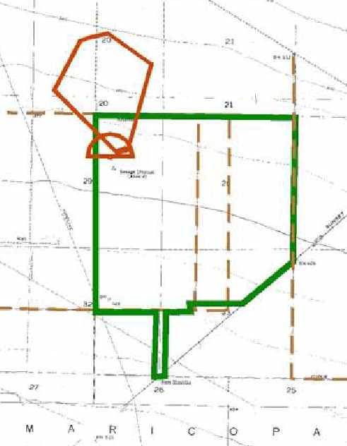
A 2003 Army Corps of Engineers map of the WW2 property boundary of Gardner AAF (in green),
along with its small arms range (in brown).
Gardner was depicted on the 1945 Mojave Aeronautical Chart (courtesy of Dan MacPherson)
with the symbol indicating that its longest runway was between 5,500-6,500'.
The 37th & last class at Gardner graduated in January 1945,
by which point the base had trained a total of 3,050 soldiers & 8,916 cadets.
Twenty-six cadets died in training flights, as did 11 of the training officers sharing cockpits with them.
Still, the number of crashes in relation to the hours flown out of Gardner Field was low.
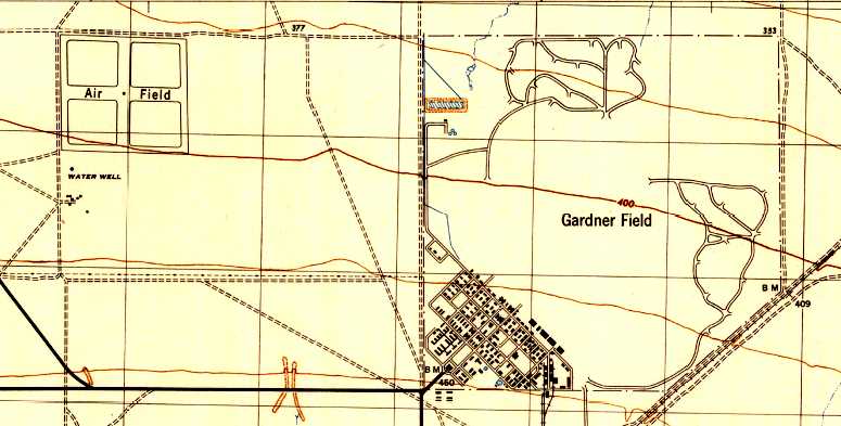
Strangely, the 1945 USGS topo map labeled the site as Gardner Field, and depicted the streets & buildings in great detail,
along with the complicated maze of aircraft revetments, but the airfield itself (runways & taxiways) was not depicted at all.
Note the depiction as well of the Taft-Kern County Auxiliary #2 to the northwest, labeled simply as “Air Field”.
Gradually, the planes left, the buildings were removed, and Gardner AAF was inactivated on 2/28/45.
Gardner Field & its auxiliary fields were transferred from the Western Flying Training Command to the jurisdiction of the Air Technical Service Command on 3/3/45.
They were subsequently placed on inactive status on 3/10/45.
Gardner Army Airfield was still depicted as an active military airfield (along with all of its auxiliary airfields) on the March 1945 LA Sectional Chart.
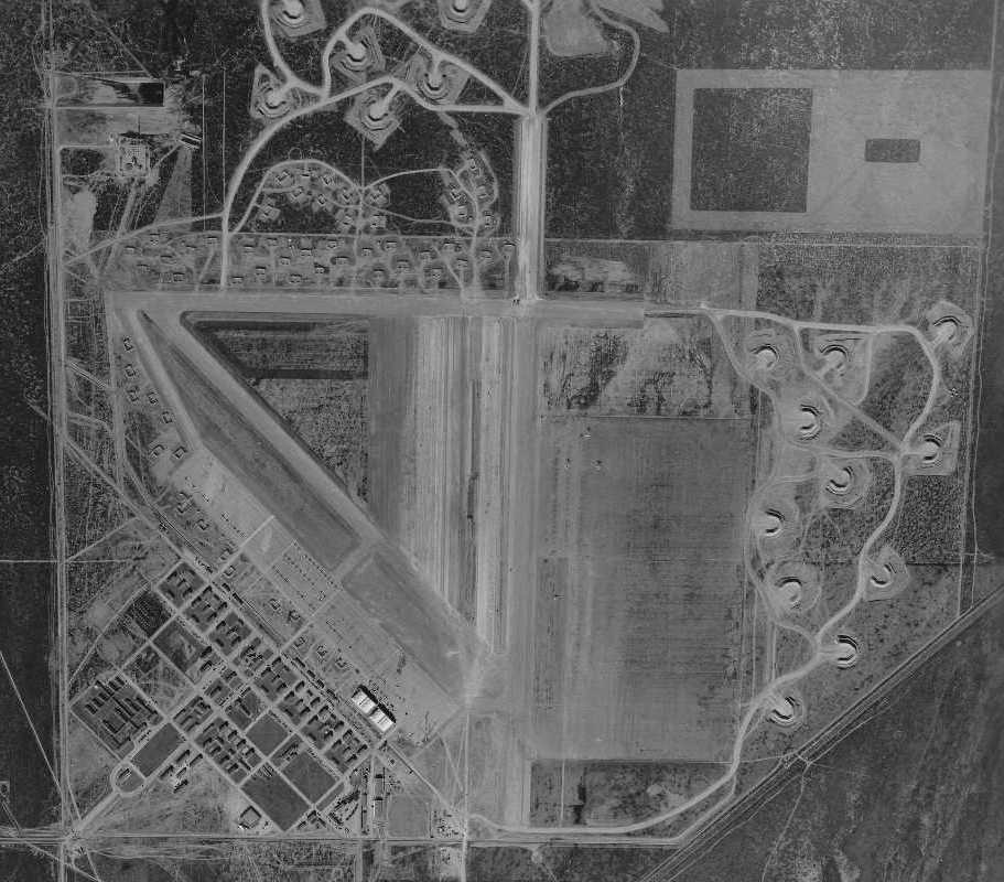
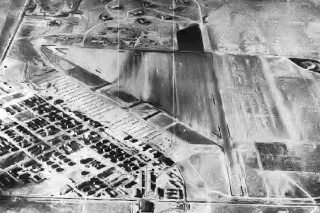
A 7/7/46 USGS aerial view showed Gardner's massive airfield & all its hangars & other buildings remained intact, though completely devoid of aircraft.
Traces remained of the extensive earthen aircraft parking revetments on the east & north sides of the airfield, although the revetments themselves had been removed.
The War Department declared Gardner Field surplus on 10/27/47.
The 447 fee-owned acres were assigned to the Farm Credit Administration on 6/14/48.
It is surmised that the 949 acres originally leased reverted to the respective owners upon expiration of the leases.
Ken Reightler recalled, “In 1947-48 I used what was left of Gardner Field for 'touch & go's'
while in Taft's GI Bill Training & in my privately-owned L-3 Aeronca.
I landed near a farm house & used their wind vane for wind direction.
I do not remember any buildings or other use of what was left of the concrete at Gardner.”
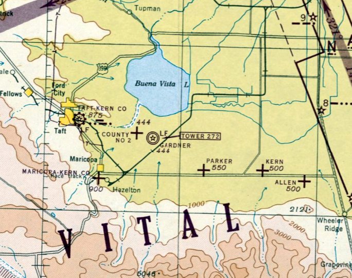
Gardner was evidently reused as a civilian airport at some point between 1945-49,
as that is how "Gardner" was depicted on the 1949 Mount Whitney Sectional Chart (courtesy of Chris Kennedy).
It was depicted as having a 6,000' hard-surface runway.
According to K.O. Eckland, as of 1950 the airfield at Gardner consisted of a 6,000' northwest/southeast paved runway.
Strangely, the 1950 USGS topo map labeled the site as Gardner Field, but no longer depicted any elements of the airfield,
as if all of the roads, buildings, and other improvements had already been wiped away.
The Gardner Airport evidently closed at some point between 1949-52,
as it was no longer depicted as an airfield of any kind on the 1952 L.A. Sectional Chart (according to Allan Greene).
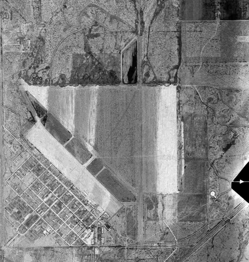
An 8/14/52 USGS aerial view (enhanced by Bill Grasha) showed most of Gardner's massive airfield remained intact though deteriorated.
Traces also remained of the extensive earthen aircraft parking revetments on the east & north sides of the airfield.
The extensive street grid remained, although every one of the buildings had been removed at some point between 1946-52.
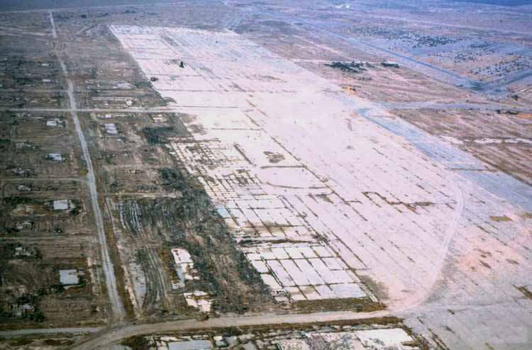
A November 1970 aerial view by K.O. Eckland taken while turning on final for Gardner's massive ramp.
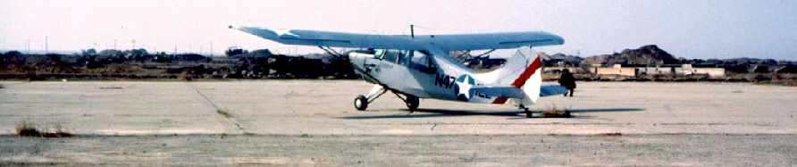
A November 1970 photo by K.O. Eckland of his Aeronca L-16B at Gardner.
Eckland recalled, “I was the last plane to land there, as it was being bulldozed at the time,
the [ramp] weedy & cracked but still usable if one tip-toed in with a ready hand on the throttle.”
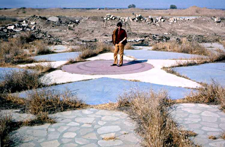
A November 1970 photo by K.O. Eckland of Ed Cruger standing on the star which remained at the site of the administration building.
Eckland observed, “Sadly no one there was interested in preserving it as a grave marker - cotton was more important.”
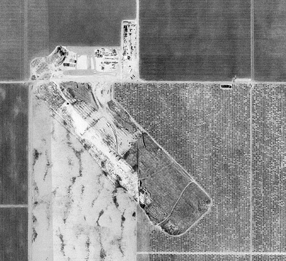
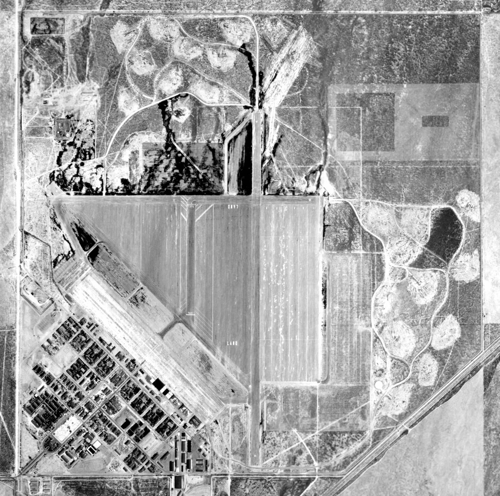
By the time of the 1994 USGS aerial photo, the site of Gardner Field had been taken over for farming.
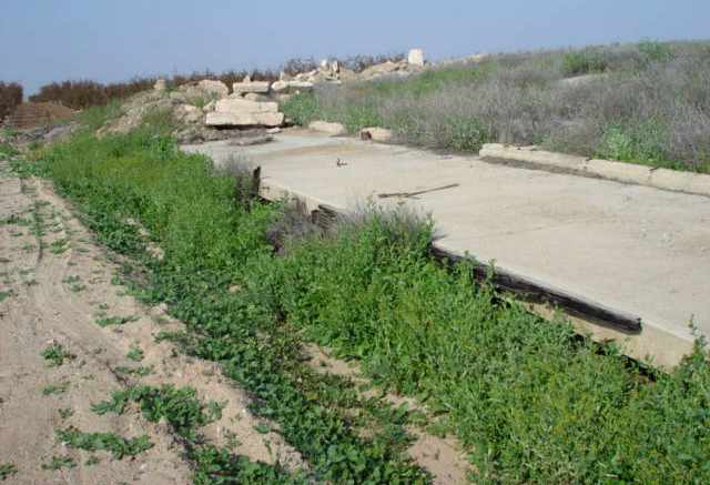
The largest remaining recognizable element of the airfield was an 1,800' concrete & asphalt ramp area.
The former runways had been removed, having reverted to agriculture.
A 2005 photo by Keith Wood of the possible ruins of former airfield buildings at the site of Gardner AAF.
Keith reported, “The only possible remnant is the ruin of a warehouse & loading docks which MAY be related.
It is just south of the road which I believe to have run along the perimeter.”
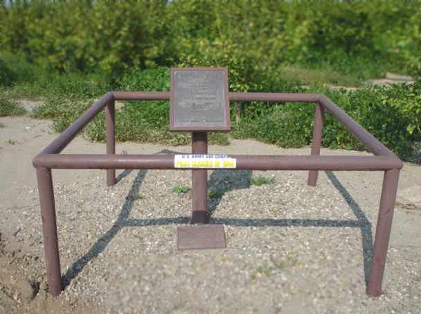
A 2005 photo by Keith Wood of a monument to Gardner AAF,
located at the site of the base's former entrance, at the intersection of Cadet & Basic School Roads.
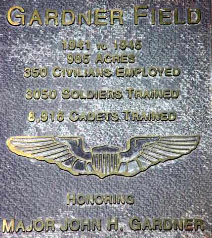
A 2005 photo by Keith Wood of the plaque on the monument at the site of Gardner AAF.
Jim reported in 2005 of the site of Gardner AAF: “I walked around the ramp & remains.
I was able to identify 2 hangar foundations, complete with door tracks.
The foundations & concrete ramp have held together, but areas have sunken into the unstable soil.
I was able to locate tie-downs outside the hangars.
The remains of a warehouse with 2 sidings is located southeast of the hangars.
The Taft Oil Museum is supposed to have wartime photos of the base.”
A 2015 aerial view showed the site of Gardner Field had been taken over for farming.
The largest remaining recognizable element of the airfield was the 1,800' concrete & asphalt ramp area, oriented northwest/southeast.
A 2022 photo of the remains of the Gardner Field pavement.
Thanks to Mel Shettle for pointing out this airfield.
____________________________________________________
Gardner Auxiliary Army Airfield #1 / Parker Field, Taft, CA
35.064, -119.205 (Northwest of Los Angeles, CA)
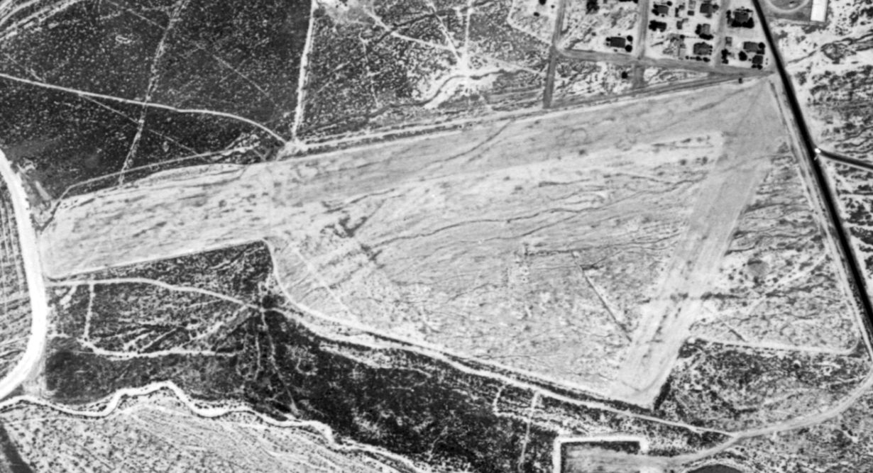
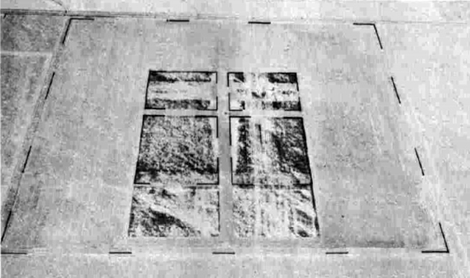
A 7/22/43 aerial view looking east at Gardner Aux AAF #1 from the 1945 AAF Airfield Directory (courtesy of Scott Murdock).
Parker Field was one of 6 satellite airfields which supported WW2 military flight training at Gardner AAF,
which was located 6 NM to the northwest.
The date of construction of Parker Field has not been determined, but its parent Gardner AAF was active by 1941.
The earliest depiction which has been located of Parker Field was an 7/22/43 aerial view looking east
from the 1945 AAF Airfield Directory (courtesy of Scott Murdock).
It depicted the field as consisting of a 3,000' square asphalt landing mat, with 4 unpaved rectangular cutouts in the middle.
Parker Field was not yet depicted on the February 1944 LA Sectional Chart.
The earliest aeronautical chart depiction which has been located of Parker Field was on the March 1945 LA Sectional Chart,
which depicted Parker as an auxiliary airfield.
The 1945 AAF Airfield Directory (courtesy of Scott Murdock) described “Gardner Field Auxiliary #1 (Parker Field)”
as having a 3,000' square bituminous landing mat, and no hangars.
The field was said to be owned by private interests, and operated by the Army Air Forces.
The parent Gardner AAF was inactivated on 2/28/45.
Gardner Field & its auxiliary fields were transferred from the Western Flying Training Command to the jurisdiction of the Air Technical Service Command on 3/3/45.
They were subsequently placed on inactive status on 3/10/45.
A 7/5/46 USGS aerial view (from the UCSB Library) depicted Parker Field as remaining intact, but without any sign of civilian reuse.
The 1947 USGS topo map did not depict Parker Field at all.
The last depiction which has been located of Parker Field was on the 1949 Mount Whitney Sectional Chart (courtesy of Chris Kennedy).
Parker Field was evidently reused (perhaps briefly) as a civilian airport,
as that is how it was depicted, with a 3,000' hard-surface runway.
An 8/15/52 USGS aerial view depicted Parker Field as remaining intact but very deteriorated.
There was no sign of any civilian reuse of the airfield.
By the time of the 1994 USGS aerial photo the location of the airfield had been taken over for farming,
and no trace was recognizable of the former airfield.
An 8/12/13 aerial photo did not show any trace remaining of Parker Field.
The site of Parker Field is located northeast of the intersection of Route 166 & Capello Road.
____________________________________________________
Gardner Auxiliary Army Airfield #2 / Taft-Kern Field, Taft, CA
35.12, -119.336 (Northwest of Los Angeles, CA)
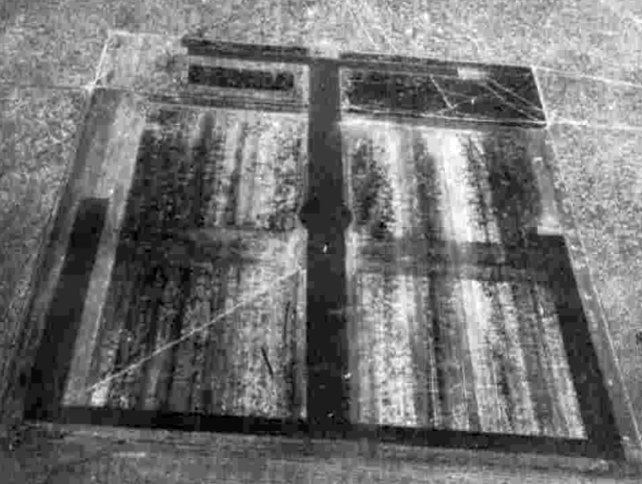
An 8/11/41 USAF aerial view (from the National Archives, via Brian Rehwinkel) of Gardner AAF Auxiliary #2.
Taft-Kern County Auxiliary Army Airfield #2 was one of 6 satellite airfields which supported WW2 military flight training at Gardner AAF,
which was located a mere 2 NM to the southeast.
The date of construction of Taft-Kern Aux #2 has not been determined,
but its parent Gardner AAF was authorized in 1940 & was active by 1941.
Taft Auxiliary #2 was initially used before Gardner Field itself was ready to support flight operations.
The earliest depiction which has been located of Taft Aux #2 was an 8/11/41 USAF aerial view (from the National Archives, via Brian Rehwinkel).
It depicted the field as having a unique configuration for a WW2 auxiliary airfield,
with 2 runways (either asphalt or oiled) in a cross shape surrounded by an outer set of taxiways forming a square.
Brian observed, “It is an interesting photo because there are 75 aircraft at the field. I can’t imagine that was the case very often.
However, I happen to also have a photo of the main field (Gardner Field) taken on the same day & the runways are under construction.
This leads me to believe this auxiliary field - given its close proximity to the main field -
and maybe other auxiliary fields were used for most flight operations while the main field was completed.”
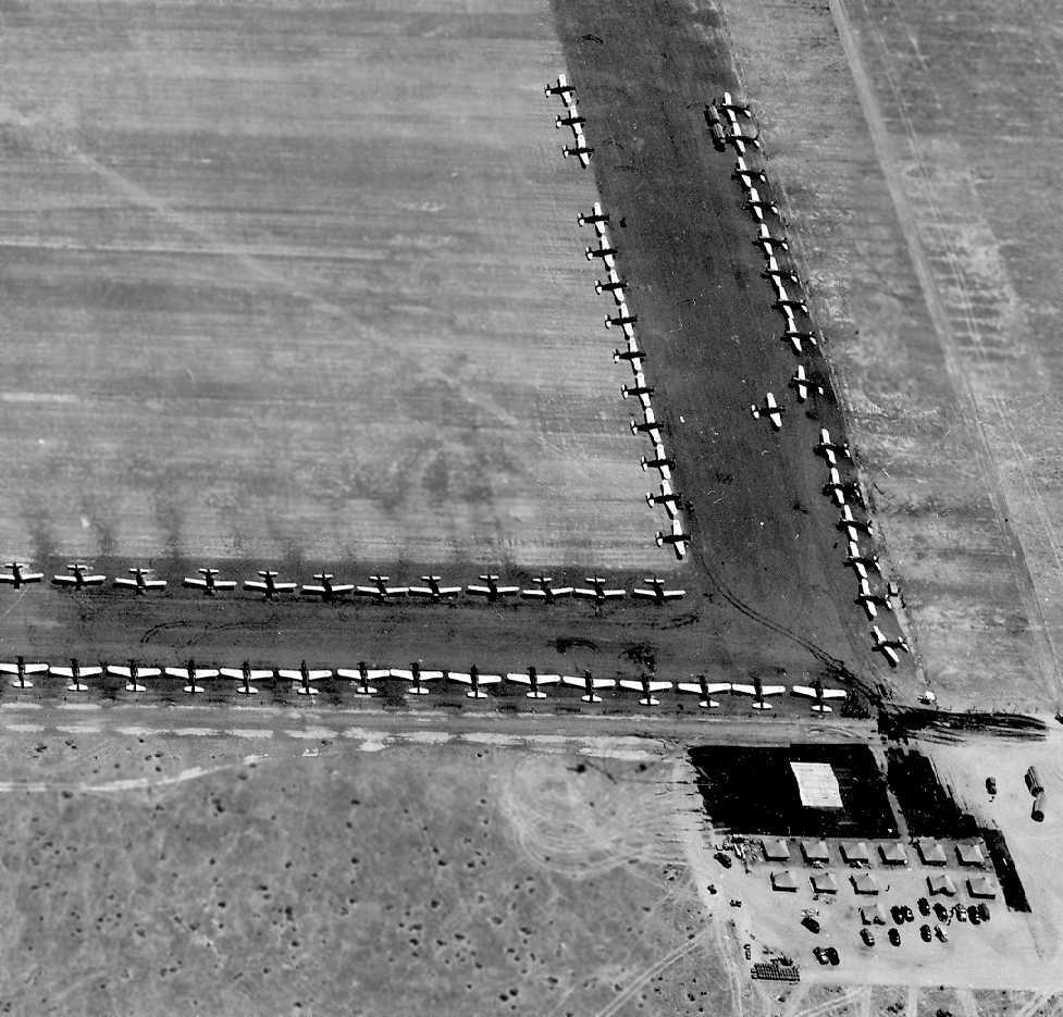
A closeup from the 8/11/41 USAF aerial view (from the National Archives, via Brian Rehwinkel)
showing some of the assemblage of 75 planes at Taft Auxiliary #2, evidently while the parent Gardner AAF was still under construction.
The last photo which has been located of Gardner Aux #2 was a 7/22/43 aerial view looking north
from the 1945 AAF Airfield Directory (courtesy of Scott Murdock).
Taft Aux #2 was not yet depicted on the February 1944 LA Sectional Chart.
The earliest aeronautical chart depiction which has been located of Taft Aux #2 was on the March 1945 LA Sectional Chart,
which depicted “County #2” as an auxiliary airfield.
The 1945 USGS topo map still depicted the unique configuration of 2 runways in a cross shape surrounded by an outer set of taxiways forming a square,
labeled simply as “Air Field”.
The parent Gardner AAF was inactivated on 2/28/45.
Gardner Field & its auxiliary fields were transferred from the Western Flying Training Command to the jurisdiction of the Air Technical Service Command on 3/3/45.
They were subsequently placed on inactive status on 3/10/45.
Taft #2 may have been reused (perhaps briefly) as a civilian airport,
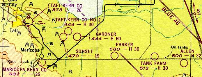
as that is how the 1949 Mount Whitney Sectional Chart (courtesy of Chris Kennedy) depicted “Taft-Kern Co #2”, with a 3,000' paved runway.
Taft #2 was no longer depicted at all on the 1950 USGS topo map.
The last photo which has been located in which the remains of Taft #2 was still recognizable was an 8/14/52 USGS aerial view.
The layout of the multiple runways remained barely recognizable, very deteriorated.
The last aeronautical chart depiction which has been located of this airfield was on the March 1952 LA Sectional Chart.
Oddly, it depicted it as “Taft-Kern Co No 11”, with a 2,600' paved runway,
and did not depicted the much larger adjacent Gardner Field at all.
Taft-Kern Co #2 was no longer depicted on the September 1952 LA Sectional Chart.
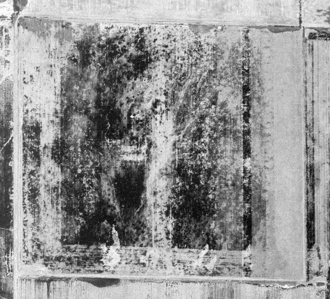
By the time of the 1994 USGS aerial photo the site of Taft #2 had been taken over for farming,
and no trace was recognizable of the former airfield.
A 4/30/11 aerial photo did not show any trace remaining of Taft Kern #2 Auxiliary Airfield.
Amazingly not even the slightest recognizable remnant remains of the runways & taxiways.
The site of Taft Kern #2 is located southeast of the intersection of South Lake Road & Gardner Airfield Road.
____________________________________________________
Gardner Auxiliary Army Airfield #3 / Allen Field, Taft, CA
35.054, -119.02 (Northwest of Los Angeles, CA)
A 7/22/43 aerial view looking north at Gardner Aux AAF #3 / Allen Field from the 1945 AAF Airfield Directory (courtesy of Scott Murdock).
Allen Field was one of 6 satellite airfields which supported WW2 military flight training at Gardner AAF,
which was located 14 NM to the northwest.
The date of construction of Allen Field has not been determined, but its parent Gardner AAF was active by 1941.
The earliest depiction which has been located of Allen Field was an 7/22/43 aerial view looking north
from the 1945 AAF Airfield Directory (courtesy of Scott Murdock).
It depicted the field as consisting of a 3,000' square asphalt landing mat, with several rectangular cutouts in the middle (of unknown purpose).
Allen Field was not yet depicted on the February 1944 LA Sectional Chart.
The earliest aeronautical chart depiction which has been located of Allen Field was on the March 1945 LA Sectional Chart,
which depicted Allen as an auxiliary airfield.
The 1945 AAF Airfield Directory (courtesy of Scott Murdock) described “Gardner Field Auxiliary #2 (Allen Field)”
as having a total of 4 bituminous landing mats, with the longest being 2 measuring 3,050' north/south.
The field was said to be owned by private interests, and operated by the Army Air Forces.
The parent Gardner AAF was inactivated on 2/28/45.
Gardner Field & its auxiliary fields were transferred from the Western Flying Training Command to the jurisdiction of the Air Technical Service Command on 3/3/45.
They were subsequently placed on inactive status on 3/10/45.
The 1947 USGS topo map did not depict Allen Field at all.
The last depiction which has been located of Allen Field was on the 1949 Mount Whitney Sectional Chart (courtesy of Chris Kennedy).
Allen Field may have been reused (perhaps briefly) as a civilian airport,
as that is how it was depicted, with a 3,200' hard-surface runway.
An 8/15/52 USGS aerial view showed that Allen Field was only barely recognizable – with the field being much more deteriorated than the other Gardner Auxiliary Airfields by that point.
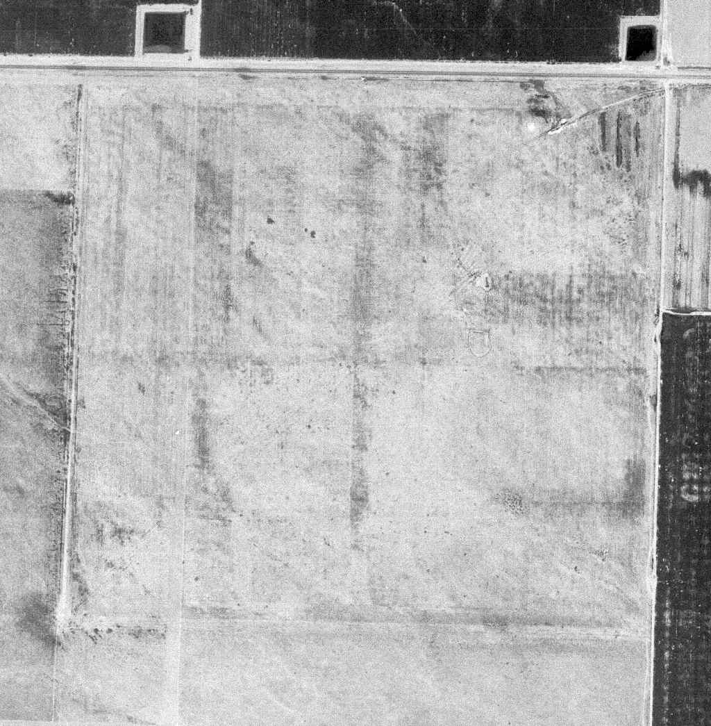
By the time of the 1994 USGS aerial photo the location of the airfield had been taken over for farming,
and no trace was recognizable of Allen Field.
An 8/12/13 aerial photo did not show any trace remaining of Allen Field.
The site of Allen Field is located southwest of the intersection of Route 166 & Interstate 5.
____________________________________________________
Gardner Auxiliary Army Airfield #6 / Cuyama Airport, Ventucopa, CA
34.85, -119.48 (Northwest of Los Angeles, CA)
Cuyama Airport, as depicted on the October 1941 LA Sectional Chart.
Cuyama Airport was evidently established at some point between 1939-41,
as it was not yet depicted on the November 1939 LA Sectional Chart.
The earliest depiction which has been located of Cuyama Airport was on the October 1941 LA Sectional Chart.
It depicted Cuyama as an auxiliary airfield.
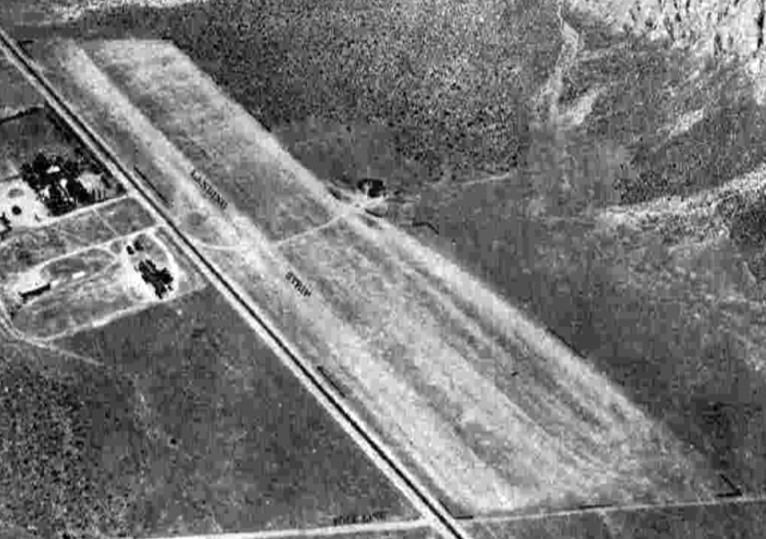
The earliest photo which has been located of Cuyama Airport was an 7/23/43 aerial view looking north from the 1945 AAF Airfield Directory (courtesy of Scott Murdock).
It depicted Cuyama as having a single unpaved northwest/southeast runway located directly adjacent to the east side of Route 33.
The 1943 USGS topo map depicted Cuyama simply as “Airport” along the east side of Route 33.
The 1945 AAF Airfield Directory (courtesy of Scott Murdock) described “Gardner Field Auxiliary #6 (Cuyama Airport)”
as a 200 acre irregularly-shaped property having a single 2,640' “sod” northwest/southeast runway.
The field was said to not have any hangars, to be owned by the U.S. Government,
and operated by the Army Air Forces & U.S. Forest Service.
The parent Gardner AAF was inactivated on 2/28/45.
Gardner Field & its auxiliary fields were transferred from the Western Flying Training Command to the jurisdiction of the Air Technical Service Command on 3/3/45.
They were subsequently placed on inactive status on 3/10/45.
The last aeronautical chart depiction which has been located of Cuyama Airport was on the March 1952 LA Sectional Chart.
It depicted Cuyama Airport as having a 2,700' unpaved runway.
Note that it also depicted the replacement New Cuyama Airport several miles to the northwest.
Cuyama Airport was evidently abandoned at some point in 1952, as it was no longer depicted on the September 1952 LA Sectional Chart.
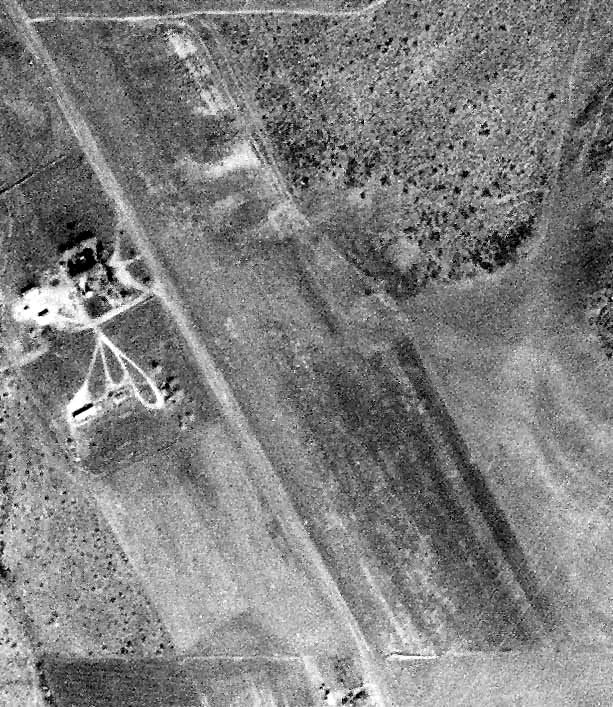
A 1/28/58 USGS aerial photo (enhanced by Bill Grasha) depicted the Cuyama Airport in a deteriorated fashion, appearing to be abandoned.
The 1982 USGS topo map continued to depict Cuyama simply as an “Airport” label on the east side of the road.
The 1991 USGS topo map no longer depicted Cuyama Airport.
By the time of the 1994 USGS aerial photo the site of Cuyama Airport had been taken over for farming,
and no trace was recognizable of the former airport.
A 4/17/13 aerial photo did not show any trace remaining of Cuyama Airport.
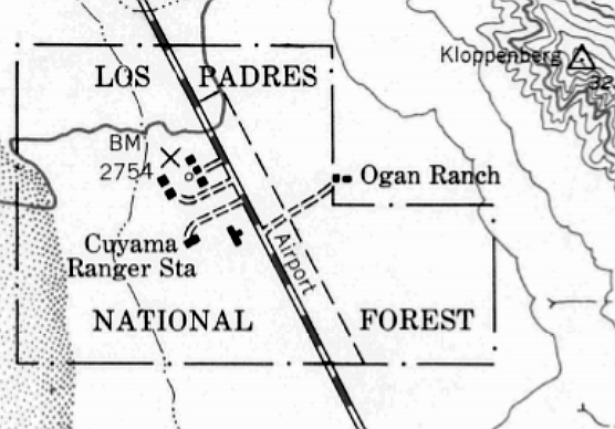
The site of Cuyama Airport is located on the east side of Route 33, south of its intersection with Big Pine Road.
____________________________________________________
Since this site was first put on the web in 1999, its popularity has grown tremendously.
If the total quantity of material on this site is to continue to grow,
it will require ever-increasing funding to pay its expenses.
Therefore, I request financial contributions from site visitors,
to help defray the increasing costs of the site
and ensure that it continues to be available & to grow.
What would you pay for a good aviation magazine, or a good aviation book?
Please consider a donation of an equivalent amount, at the least.
This site is not supported by commercial advertising –
it is purely supported by donations.
If you enjoy the site, and would like to make a financial contribution,
you
may use a credit card via
![]() :
:
Please consider checking the box to make a monthly donatation.
For a mailing address to send a check, please contact me at: paulandterryfreeman@gmail.com
If you enjoy this web site, please support it with a financial contribution.
This site covers airfields in all 50 states.