Abandoned & Little-Known Airfields:
Southeastern Arizona
© 2002, © 2025 by Paul Freeman. Revised 7/11/25.
____________________________________________________
Please consider a financial contribution to support the continued growth & operation of this site.
Benson Intermediate Field / (Original) Benson Airport (revised 4/21/18) - Bowie Airport (1st location) (revised 7/11/25) - Bowie Airport (2nd location) (revised 11/11/23)
Cochise Intermediate Field (revised 7/4/19) - Douglas Aux AAF #2 / Forrest Field (revised 4/13/22) - Douglas Aux AAF #3 / Webb Field (revised 7/11/25)
Douglas Aux AAF #5 / Hereford Field (revised 7/11/25) - Fort Grant Airport / Angel Field (revised 7/11/25)
____________________________________________________
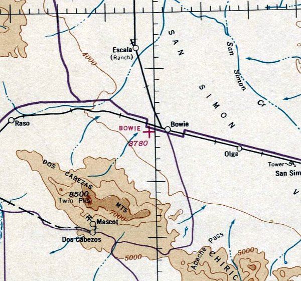
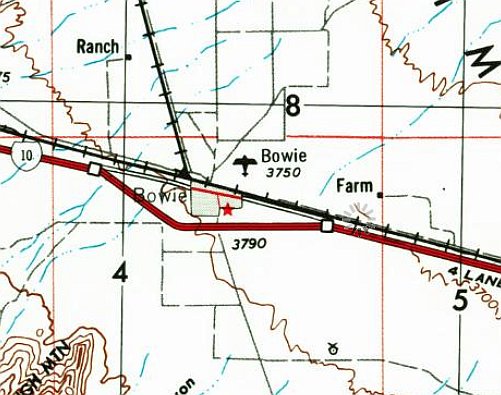
Bowie Airport (1st location), Bowie, AZ
32.328, -109.508 (East of Tucson, AZ)
Bowie Airport, as depicted on the May 1939 Phoenix Sectional Chart.
Photo of the airfield while operational has not been located.
The original Bowie Airport was located west of the town.
According to a 8/1/29 Arizona Republic article (courtesy of Bill Grasha), "The Bowie airport site has been selected & volunteers will be called for to clean & level the land.
The date of dedication also will be set a little later."
According to a 10/17/29 Arizona Republic article (courtesy of Bill Grasha), "The first airplane ever to land on the new Bowie airport visited here last Thursday
when Pilot Brophy of Tucson landed his plane & then took D. T. Milner, president of the Bowie chamber of commerce, for a flight over the surrounding district."
Bill Grasha reported, “Other articles indicate the pilot Brophy was in the crop-dusting business. Seems they dusted cotton with arsenic back then.”
According to a 4/30/30 Arizona Republic article (courtesy of Bill Grasha), "The Chamber of Commerce here has received material with which to mark the Bowie Airport.
A wind signal recently erected & the field is now in good condition for flyers."
The 1931 Commerce Department Airway Bulletin (courtesy of Bill Grasha) described Bowie Airport as an auxiliary airfield located a mile west of the town,
consisting of a 1,866' square sod field having 2 runways measuring 1,980' north/south & east/west.
Bowie Airport was said to have no servicing facilities.
The first Bowie Airport was evidently closed (for reasons unknown) at some point between 1931-35,
as it was no longer depicted on the October 1935 Phoenix Sectional Chart or the July 1937 Phoenix Sectional Chart.
Bowie Airport was evidently reopened at some point between 1937-39,
as it was once again depicted on the May 1939 Phoenix Sectional Chart.
Bowie Airport was not depicted on the 1944 USGS topo map.
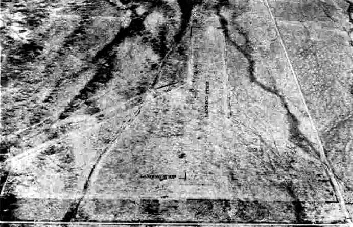
A 1947 aerial view of the site of the original Bowie Airport depicted a cleared dirt square, beyond which extended 2 unpaved runways.
In 1953 a replacement Bowie Airport was reportedly established on the northeast side of the town.

The last aeronautical chart depiction which has been located of the original Bowie Airport was on the March 1956 Phoenix Sectional Chart.
It depicted the Bowie Airport to the west of the town as having a 2,000' unpaved runway.
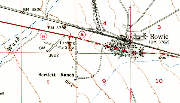
Even though it had presumably been closed for over 2 decades, 2 runways of the original Bowie Airport were still depicted on the 1957 USGS topo map, generally labeled as “Landing Strip”.
No Bowie Airport was depicted on the March 1960 Phoenix Sectional Chart.
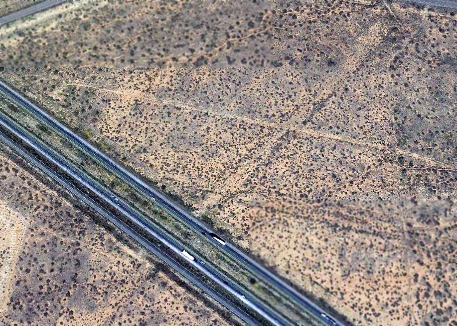
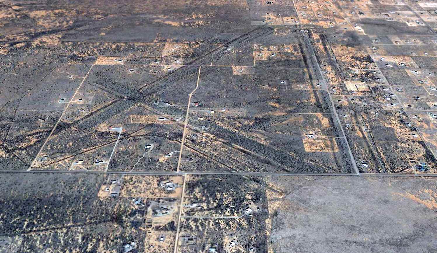
A 2015 aerial view looking north showed the ghosted alignment of the 2 runways at the site of the original Bowie Airport, with Interstate 10 cutting across the southwestern portion.

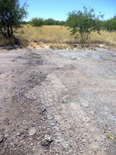
A February 2024 photo looking northeast at the site of the original Bowie Airport.
Thanks to Bill Grasha for pointing out this airfield.
____________________________________________________
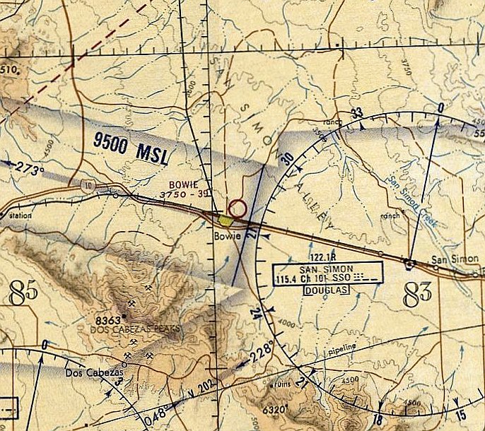
Bowie Airport (2nd location), Bowie, AZ
32.336, -109.474 (Southeast of Tucson, AZ)
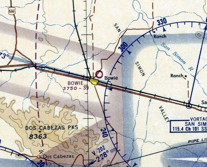
The 2nd location of Bowie Airport, as depicted on the January 1965 Phoenix Sectional Chart.
Photo of the airfield while operational has not been located.
A predecessor Bowie Airport was located on the west side of the town.
This 2nd location of Bowie Airport was built on the northeast side of the town.
According to a 6/4/53 Arizona Republic article (courtesy of Bill Grasha), "Don Foster, Secretary of San Simon Chamber of Commerce,
attended the meeting of Cochise County Supervisors in Bisbee Monday to make final arrangements for the county's acquirement of land for the new Bowie Airport.
The Bowie airport will be located northeast of Bowie & is reported to have a runway 4,000' long.
It is expected the airport will be ready for landings within the next 30 days, at which time an inaugural ceremony is planned.”
However, Bowie Airport was not depicted on the March 1961 Phoenix Sectional Chart.
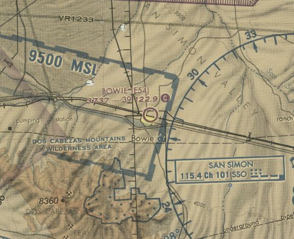
Bowie Airport, as depicted on the January 1965 Phoenix Sectional Chart.
It depicted Bowie Airport as having a 3,900' unpaved runway.
Bowie Airport, as depicted on the 1970 USGS topo map.
The January 1971 Phoenix Sectional Chart depicted Bowie Airport as having a 3,900' unpaved runway.

The 1974 USGS topo map depicted Bowie Airport as a single unpaved east/west runway, generically labeled “Landing Strip”.
A 1996 aerial view depicted the Bowie Airport runway as remaining clear, but there was no indication of any recent aviation use.
The last aeronautical chart depiction which has been located of Bowie Airport was on the 1998 Phoenix Sectional Chart (courtesy of Jonathan Westerling).
It depicted Bowie Airport as having a 3,900' unpaved runway.
Bowie Airport was evidently closed (for reasons unknown) at some point between 1998-2004,
as it was no longer depicted on the 2004 Phoenix Sectional Chart (courtesy of Jonathan Westerling) or the the 2014 USGS topo map.
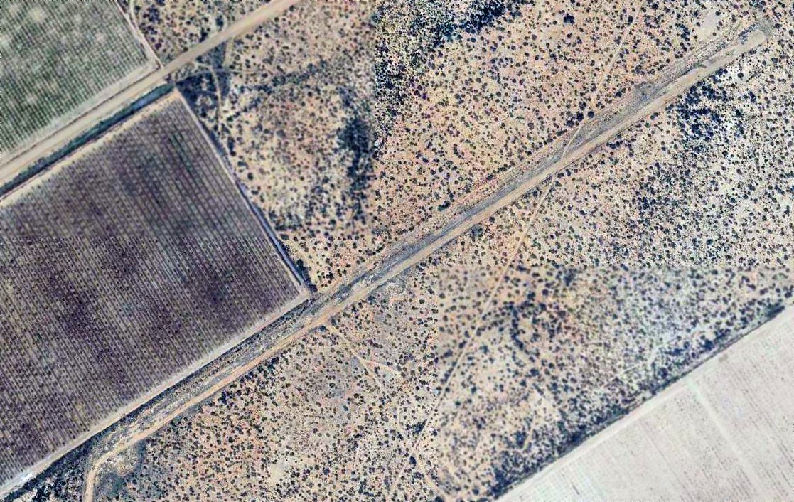
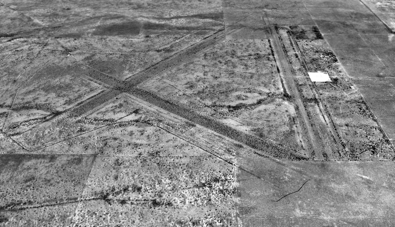
A 2015 aerial view looking northeast showed the remains of the unpaved east/west runway at the site of the 2nd location of Bowie Airport.
The site of the 2nd location of Bowie Airport is located at the northeastern terminus of Airport Road, appropriately enough.
Thanks to Bill Grasha for pointing out this airfield.
____________________________________________________
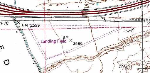
Benson Intermediate Field / (Original) Benson Airport (31AZ), Benson, AZ
31.96, -110.26 (Southeast of Tucson, AZ)
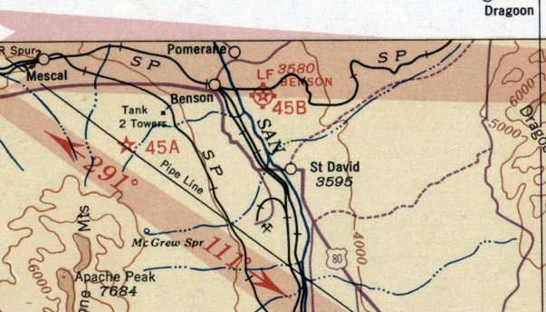
Benson Intermediate Field, as depicted on the April 1935 Douglas Sectional Chart.
Photo of the airfield while operational has not been located.
This little airport has been opened, closed, and reopened multiple times throughout its 70-year lifespan.
The original airport for the town of Benson was located southeast of the town.
It was originally established as one of the network of emergency landing fields built by the Bureau of Air Commerce.
The Benson Intermediate Field was evidently built at some point between 1930-31,
as it was not yet listed in a 1930 Department of Commerce Airway Bulletin (courtesy of David Brooks).
The earliest reference which has been located of the Benson Intermediate Field
was in the 1931 Department of Commerce Airway Bulletin (courtesy of David Brooks).
It was described as being the Department of Commerce's Site 45B,
located 2 miles east of town, and having a 4,000' east/west runway.
The earliest depiction which has been located of the Benson Intermediate Field
was on the April 1935 Douglas Sectional Chart, which depicted it as Site 45B.
Benson continued to be listed as Site 45B up through the 1936 Department of Commerce Airway Bulletin (courtesy of David Brooks).
By the time of the 1938 Department of Commerce Airway Bulletin (courtesy of David Brooks),
Benson's designation had evidently changed to Site 14B.
It continued to be listed as Site 14B in the Airport Directory Company's 1939 Airport Directory (according to David Brooks).
Benson Airport was depicted on the 1941 12M Regional Aeronautical Chart (according to David Brooks).
Benson Airport may have been closed for a few years during WW2 (as was the case with many small civilian airports),
as it was not depicted at all on the September 1942 Douglas Sectional Chart (according to Chris Kennedy)
or the March 1945 Douglas Sectional Chart (according to Chris Kennedy).
Benson Airport was evidently reopened at some point between 1945-46.
Wes Stewart recalled of the original Benson Airport, “My late father learned to fly there from Skeet, who was the FBO of the airport.
I have my dad's logbook & his first entry was 7/28/46.
Skeet also taught 'Ike' Russell, the subject of the book, 'Backcountry Pilot'.
Skeet was a real character. He had a small 'club' next to the hangar where at times he had a few slot machines.
These of course were illegal, but somehow Skeet knew when it was safe to have them & when it was not.
I remember playing with one at home after my dad brought it back to Tucson to 'hide it out'
because of a tip that there was going to be a raid by the Cochise County Sheriff.
And yes, there really was a 'golf course', which of course was totally dirt, without a blade of grass.”
Benson Airport was once again depicted on the January 1949 Douglas Sectional Chart (according to Chris Kennedy)
and the September 1952 Phoenix Sectional Chart (according to Chris Kennedy).
Benson Airport may have closed (once again) at some point between 1952-53,
as it was no longer depicted on the September 1953 Phoenix Sectional Chart (according to Chris Kennedy)
or the March 1958 Phoenix Sectional Chart (according to Chris Kennedy).
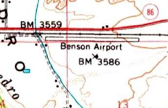
The 1958 USGS topo map depicted the Benson Airport as having a single east/west runway,
with one small building on the southwest side of the field.
Benson Airport evidently reopened (again) at some point between 1958-61,
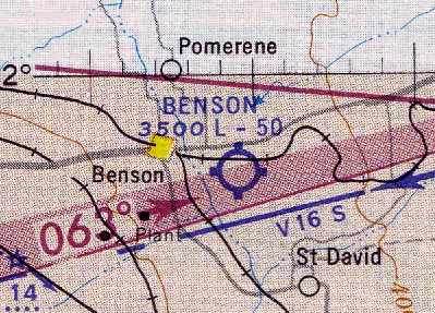
as the March 1961 Douglas Sectional Chart (courtesy of Chris Kennedy) depicted Benson as having a 5,000' unpaved runway.
The 1962 AOPA Airport Directory described Benson Airport as having 3 dirt & silt runways,
with the longest being the 5,000' Runway 9/27 & the 5,000' Runway 4/22.
The field was described as offering major repairs, fuel, and hangars, and the operator was listed as Neil Taylor.
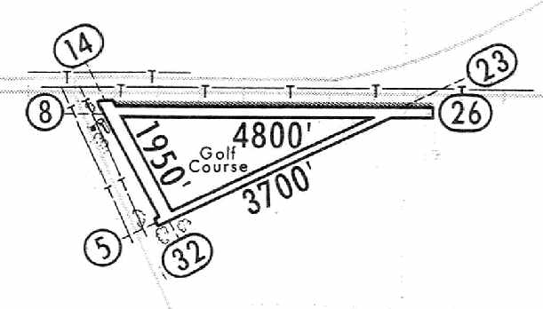
The 1964 Jeppesen Airway Manual (courtesy of Chris Kennedy) depicted Benson as having 3 dirt runways,
with the longest being the 4,800' Runway 8/26, and a single building on the northwest corner of the field.
Curiously, the triangle within the 3 runways was labeled as a “golf course”.
Benson Airport was no longer listed among active airfields in the 1974 Flight Guide (courtesy of Fred Udall).
The 1983 USGS topo map depicted 3 runways at Benson, but labeled the field merely as “Landing Field”.
It also depicted a single small building at the northwest corner of the field.
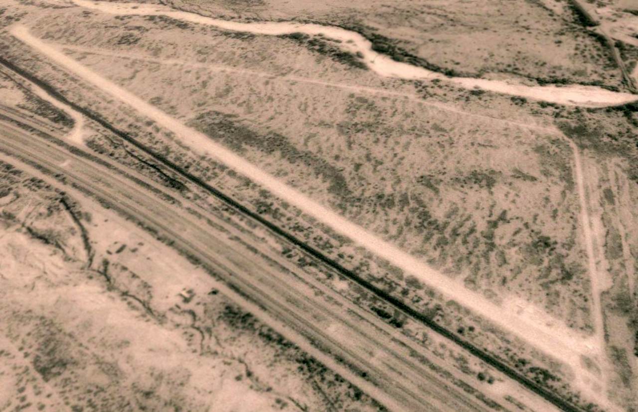
In a 1992 USGS aerial view looking southeast, Benson's east/west runway still remained quite well cleared,
but there was no other obvious sign of use of the airfield – there were no aircraft evident on the field.
A single building was depicted at the northwest corner of the field.
In 1999 the larger Benson Municipal Airport (with a paved runway) was opened 3 miles northwest of the town of Benson.
The status of the original Benson Airport may have been changed to a private field at that point.
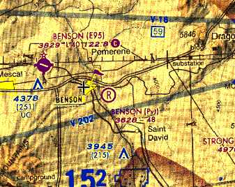
The 2005 sectional chart depicted the original Benson Airport as a private field, with a 4,800' unpaved runway.
In 2005 the original Benson Airport was still listed with the FAA as an active private airfield, owned by Ben Taylor.
The field was described as having a single 4,800' dirt Runway 8/26,
but it was listed with the notes, “Use at pilots own risk - prior contact recommended. Gopher holes, slick & muddy when wet.”
The field was also described as being home to 8 single-engine aircraft,
and was said to conduct an average of 58 takeoffs or landings per month.
However, AirNikon visited the site of the original Benson Airport in 2005,
and found it to be very much abandoned, with no sign of any aircraft at the field, or any other indication of recent airfield usage.
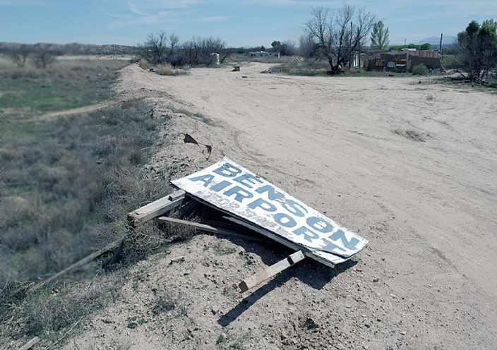
A 2005 photo by AirNikon of a knocked-down sign reading “Benson Airport for sale.”
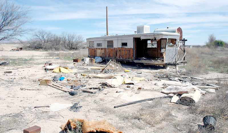
A 2005 photo by AirNikon of an abandoned trailer at the site of Benson Airport.
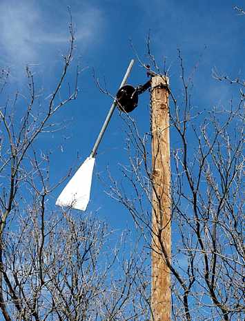
A 2005 photo by AirNikon of what appears to have been a wind direction indicator at the site of Benson Airport.
A circa 2006 aerial view (enhanced by Bill Grasha) looking northeast at the remains of the 2 runways at the site of Benson Airport.
The original Benson Airport is located southeast of the intersection of Interstate 10 & East Benson Airport Road, appropriately enough.
____________________________________________________
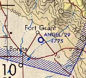
Fort Grant Airport / Angel Field, Fort Grant, AZ
32.61, -109.95 (Northeast of Tucson, AZ)
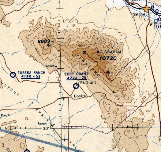
Fort Grant Airport, as depicted on the September 1960 Phoenix Sectional Chart.
Angel Field was apparently built at some point in 1960, as it was not depicted on the April 1960 Phoenix Sectional Chart.
The earliest depiction which has been located of Fort Grant Airport was on the September 1960 Phoenix Sectional Chart,
and described as having a 2,500' unpaved runway.
The 1962 AOPA Airport Directory described Angel Field as having 3 dirt runways, with the longest being the 2,500' Runway 1/19.
Fort Grant Airport was not yet depicted on the 1964 USGS topo map.
Angel Airport, as depicted on the August 1971 USAF Tactical Pilotage Chart (courtesy of Chris Kennedy).
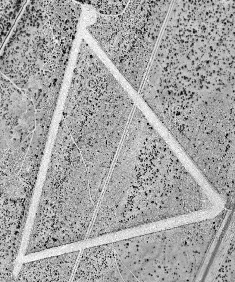
The earliest photo that has been located of Angel Field was a 10/30/71 USGS aerial photo, which depicted the field as having 3 runways.
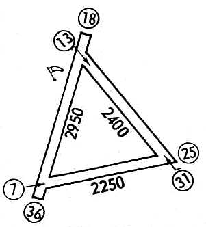
Angel Field, as depicted in the 1972 Flight Guide (courtesy of Chris Kennedy).
Angel Field was depicted as having 3 unpaved runways on the 1975 USGS topo map.
The last airport directory reference which has been located to Angel Field was in the 1976 AOPA Airport Directory (according to Chris Kennedy).
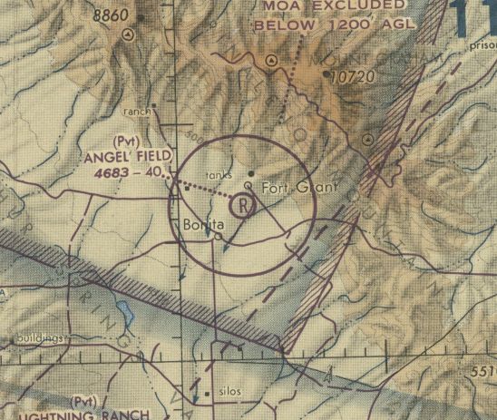
The last aeronautical chart depiction which has been located of Angel Field was on the 1978 Phoenix Sectional Chart (courtesy of Jonathan Westerling).
It depicted Angel Field as a private airfield having a 4,000' unpaved runway.
Angel Field was evidently closed (for reasons unknown) at some point between 1978-88,
as it was no longer depicted on the 1988 Phoenix Sectional Chart (courtesy of Jonathan Westerling).
The 1994 USGS topo map depicted Angel Field's 3 runways, but generically labeled "Landing Strip".
A 1996 USGS aerial view looking northwest showed Angel Field' Runway 18/36 had apparently been lengthened to 4,000' at some point between 1972-96.
It also appeared as if Route 266 (which leads to the town of Fort Grant) had been relocated from the west side of the airfield to immediately adjacent to the east side of the runways,
which was presumably a contributory factor in the airport's closure.
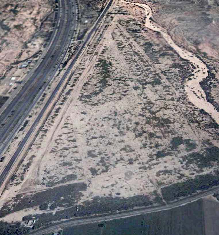
A 2016 aerial view looking northwest showed the former Angel Field remains in basically the same condition.

A January 2024 photo looking west along 2 former Angel Field runways.
Angel Field is located west of Route 266, a half-mile south of the town of Fort Grant.
____________________________________________________
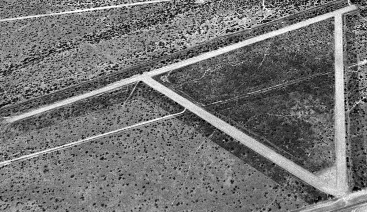
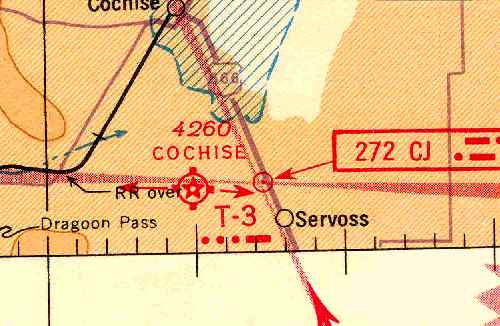
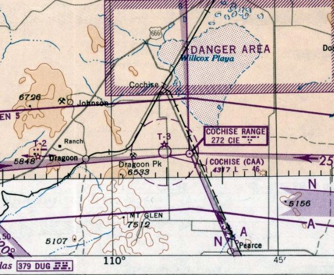
Cochise Intermediate Field, Cochise, AZ
32.03, -109.91 (East of Tucson, AZ)
Cochise Intermediate Field, as depicted on the September 1941 Phoenix Sectional Chart (courtesy of Chris Kennedy).
Cochise was one of the network of emergency landing fields built by the Bureau of Air Commerce in the 1930s & 1940s.
The Cochise airfield was evidently established at some point in 1940,
as it was not listed among active airfields in The Airport Directory Company's 1938 Airport Directory (according to Chris Kennedy)
nor depicted on the April 1940 Phoenix Sectional Chart.
The earliest depiction of the Cochise airfield which has been located was on a 1940 aerial photo.
It depicted the airfield as consisting of an irregularly-shaped unpaved area,
in the same shape as that eventually depicted on the 1943 topo map.
Two small buildings were visible at the northeast corner of the field.
The earliest aeronautical chart depiction of the Cochise airfield which has been located
was on the September 1941 Phoenix Sectional Chart (according to Chris Kennedy).
It depicted Cochise as Site T-3.
The Airport Directory Company's 1941 Airport Directory (according to Chris Kennedy)
described Cochise as having 2 runways, measuring 3,620' north/south & 2,610' east/west.
Cochise was reportedly operated by the Army Air Force during WW2.
The 1943 USGS topo map (courtesy of Chris Kennedy)
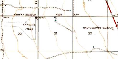
depicted the Cochise “Landing Field” as having an irregularly-shaped outline,
with an airway beacon & 2 small buildings at the northeast corner of the field,
and a radio range beacon to the east.
The earliest photo which is available of the Cochise Intermediate Field
was a 6/16/43 aerial view looking west from the 1945 AAF Airfield Directory (courtesy of Scott Murdock).
It depicted the field as consisting of an irregularly-shaped unpaved area.
Cochise was described by the 1944 US Army/Navy Directory of Airfields (courtesy of Ken Mercer) as having a 4,600' runway,
and it was described as Site T-3 along the Phoenix – El Paso Airway.
The directory did not give any indication of military use of the airfield, however.
The 1945 AAF Airfield Directory (courtesy of Scott Murdock) described the “Cochise Intermediate Field”
as a 154 acre T-shaped property having 2 sand & loam runways, measuring 4,160' east/west & 3,620' north/south.
Cochise was not said to have any hangars, to be owned by private interests, and operated by the Civil Aeronautics Administration.
The last aeronautical chart depiction which has been located of the Cochise airfield was on the February 1950 Phoenix Sectional Chart.
It depicted the “Cochise (CAA)” airfield as having a 4,600' unpaved runway.
The Cochise airfield was apparently abandoned at some point in 1950,
as it was no longer depicted on the August 1950 Phoenix Sectional Chart.
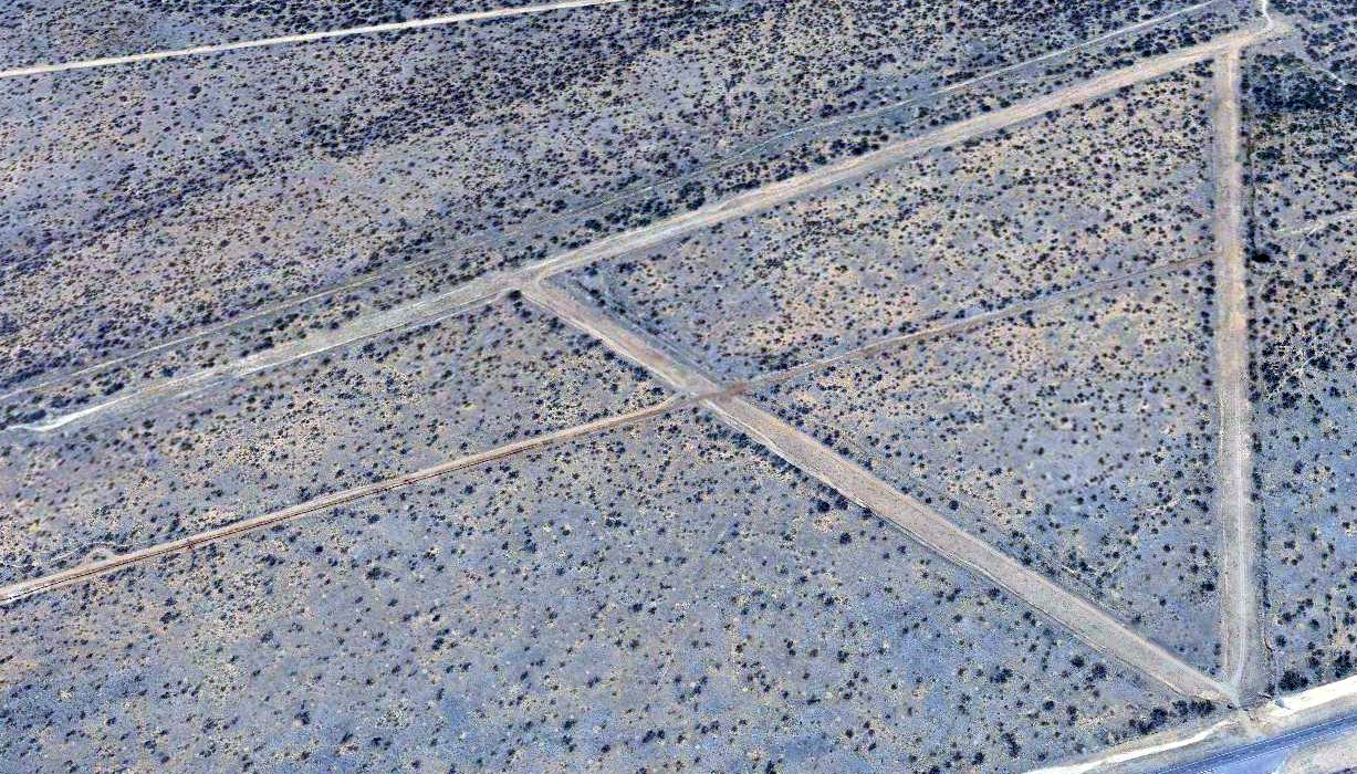
The 1958 USGS topo map no longer depicted anything at the site of the Cochise Intermediate Field,
but it did still depict the “Radio Range Station” to the east.
No trace of the Cochise airfield was still recognizable on the 1992 USGS aerial photo.
No trace of the Cochise airfield was still recognizable on a 6/12/11 aerial photo.
See also: http://www.airforcebase.net/aaf/if_list.html
____________________________________________________
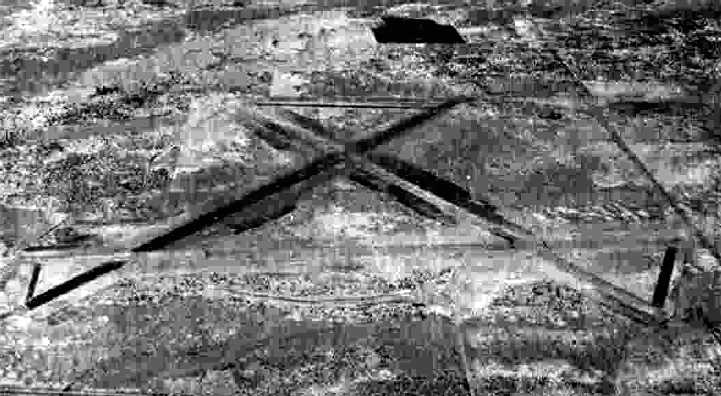
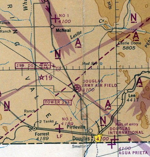
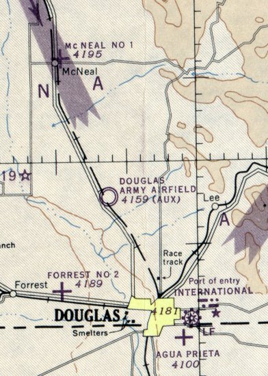
Douglas Auxiliary Army Airfield #2 / Forrest Field, West of Douglas, AZ
31.37, -109.67 (SE of Tucson, AZ)
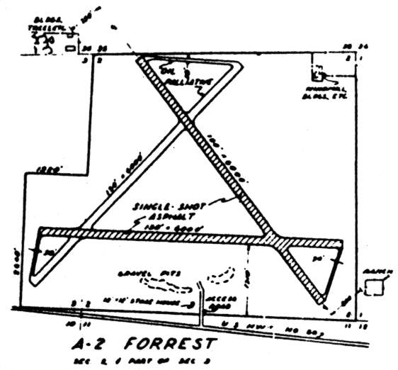
The airfield layout of Forrest, from a 1942 USAAF map of Douglas AAF & its satellite airfields (courtesy of John Voss).
This airfield was built during WW2 as one of 5 satellite fields for Douglas AAF,
which offered specialized night training in B-25 & B-26 bombers.
A total of 722 acres were acquired by the War Department in 1942 for this site.
Improvements included three 6,000' runways, taxiways,
a stage house, crash station, barracks, latrine, and night lighting system.
The earliest photo which has been located of the Forrest Auxiliary Field
was a 6/16/43 aerial view looking north from the 1945 AAF Airfield Directory (courtesy of Scott Murdock).
It depicted “Douglas AAF Auxiliary #2 (Forrest Field)” as having 3 paved runways.
The earliest aeronautical chart depiction which has been located of Douglas Aux #2 was on the February 1944 Douglas Sectional Chart.
"Forrest Aux #2, Army" was described by the 1944 US Army/Navy Directory of Airfields (courtesy of Ken Mercer)
as having a 6,000' hard-surface runway.
"Forest #2" was still depicted as an active military airfield on the 1945 Douglas Sectional Chart (courtesy of Chris Kennedy).
The 1945 AAF Airfield Directory (courtesy of Scott Murdock) described “Douglas AAF Auxiliary #2 (Forrest Field)”
as a 709 acre irregularly-shaped property having 3 asphalt 6,000' runways.
Forrest was not said to have any hangars, to be owned by the U.S. Government, and operated by the Army Air Forces.
The last aeronautical chart depiction which has been located of "Forest #2" was on the July 1946 Douglas Sectional Chart.
The Forrest Auxiliary Air Field site was declared surplus & transferred to the War Assets Administration in 1947 for disposal.
The majority of the property was sold back to private owners.
A portion was transferred to the Arizona State Board of Directors,
and was used as part of the present-day Cochise College Airport, adjacent to Forrest Airport to the west
(strange that they would build a brand-new airport right beside an already-built airport with multiple paved runways?)
The Forrest was not depicted at all on the 1949 Douglas Sectional Chart (according to Chris Kennedy).
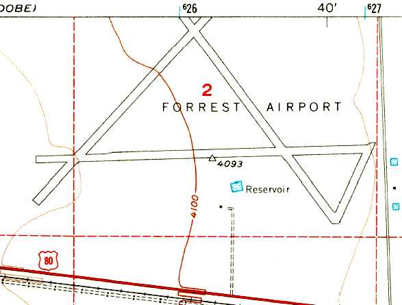
The 1957 USGS topo map depicted "Forrest Airport" as having 3 paved runways.
Forrest Airport was depicted as "Abandoned airport" on the 1966 Douglas Sectional Chart (according to Chris Kennedy).
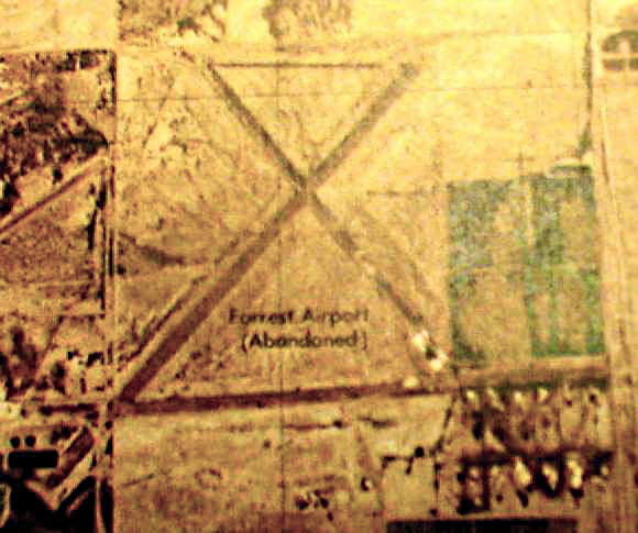
A 1982 USGS aerial photo (enhanced by Bill Grasha) of the "Forrest Airport (Abandoned)".
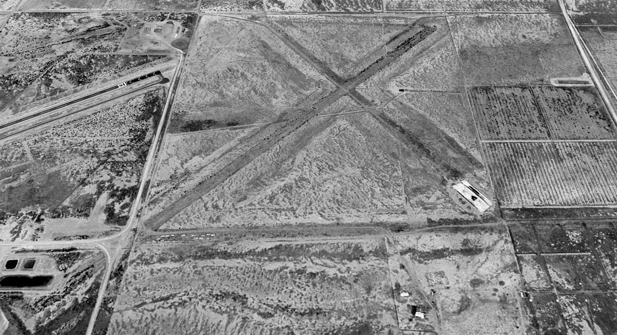
A 1996 USGS aerial view looking north showed the Forest Airport layout was still completely recognizable,
but the majority of the site had deteriorated & was overgrown with range vegetation.
A May 2014 photo by Mike Jamison of the remains of Forest Auxiliary Field.
Mike reported, “Well-defined runways, while walking at ground level, were virtually non-existent.
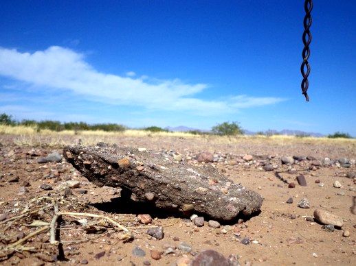
However, I did find numerous asphalt tells on the south runway's border, which seemed like more solid evidence than randomly spaced bushes.
The field's location mostly within private farmland greatly restricts exploration, so I photographed whatever evidence was publicly available.
Note that the asphalt pic has a wire-fence pigtail, dangling in full view.
I wanted to prove the picture was taken on the fence's legally-accessible side.”
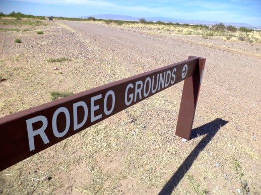
A May 2014 photo by Mike Jamison “of a Cochise Community College traffic sign, which sits right in the middle of Forest's south runway.
What appears to be a very faint runway imprint is just visible in the upper right.
Do not confuse the graded road next to the sign with a runway. The graded road is college-maintained & leads to Cochise rodeo grounds.
Forest's old runway runs diagonally across the graded road, at almost the same angle as the sign.”
A 2016 aerial view looking north showed the 3 former Forest Airport runways remained recognizable.
Forrest Airfield is located northwest of the intersection of Route 80 & North Brooks Road, only 2 miles north of the Mexican border.
____________________________________________________
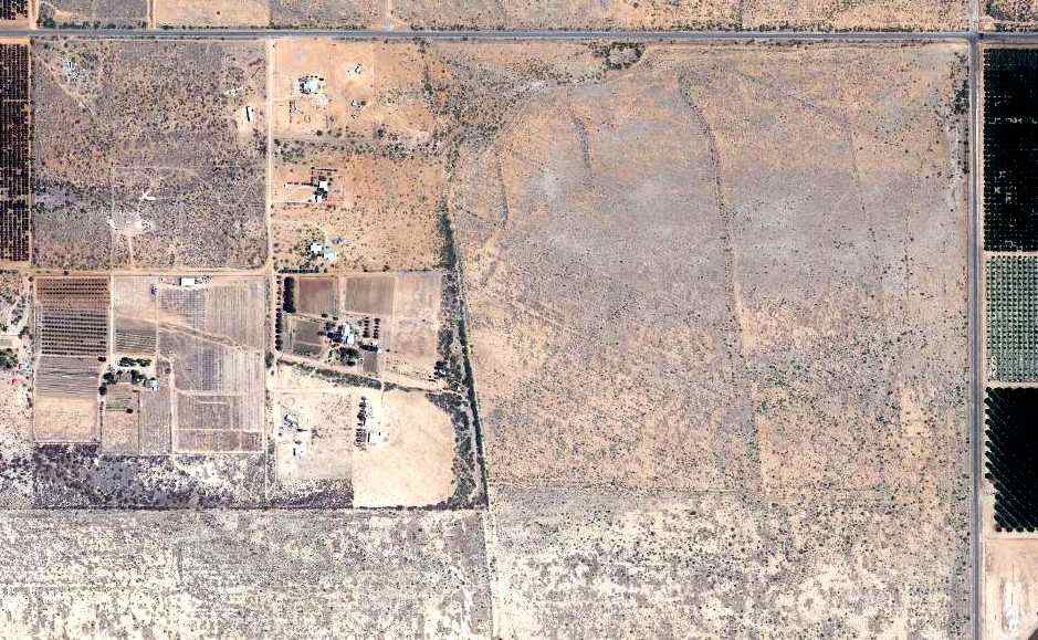
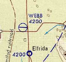
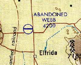
Douglas Auxiliary Army Airfield #3 / Webb Field, Elfrida, AZ
31.77, -109.7 (SE of Tucson, AZ)
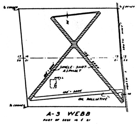
The airfield layout of Webb, from a 1942 USAAF map of Douglas AAF & its satellite airfields (courtesy of John Voss).
Photo of the airfield while operational has not been located.
This field was built as one of 5 WW2-era satellite airfields for Douglas AAF,
which offered specialized night training in B-25 & B-26 bombers.
As depicted on a 1942 AAF map, the airfield at Web Aux #3 consisted of 3 runways,
two asphalt & one oiled (the longest being 6,000') and a taxiway.
By 1944, the Webb airfield had apparently been abandoned by the military,
as it was not depicted at all on the February 1944 Douglas Sectional Chart
or the July 1946 Douglas Sectional Chart
At some point between 1946-49 it was apparently reopened as a civil airfield,
as it was labeled "Webb" on the 1949 Douglas Sectional Chart (according to Chris Kennedy),
and described as having a 5,500' hard-surface runway.
The earliest aerobautical chart depiction which has been located of Webb Airport was on the July 1950 Douglas Sectional Chart,
which depicted the field as having a 5,500' paved runway.
The Aerodromes table on the 1956 Douglas Sectional Chart (courtesy of John Voss)
described Webb as having a single 5,000' bituminous runway.
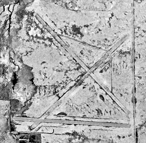
The earliest photo which has been located of Webb Airport was a 9/20/57 USGS aerial view (enhanced by Bill Grasha),
which depicted the field as having 3 paved runways.
Webb Airport was still depicted as an active civil airfield
on the October 1961 USAF Operational Navigational Chart (courtesy of Chris Kennedy).
Strangely, none of the Webb runways were depicted on the 1963 USGS topo map.
Webb Airport was apparently closed again at some point between 1961-65,
as it was labeled "Abandoned" on the December 1965 USAF Operational Navigational Chart (courtesy of Chris Kennedy).
Only a single east/west runway was depicted on the 1986 & 1990 USGS topo maps, labeled simply "Landing Strip".
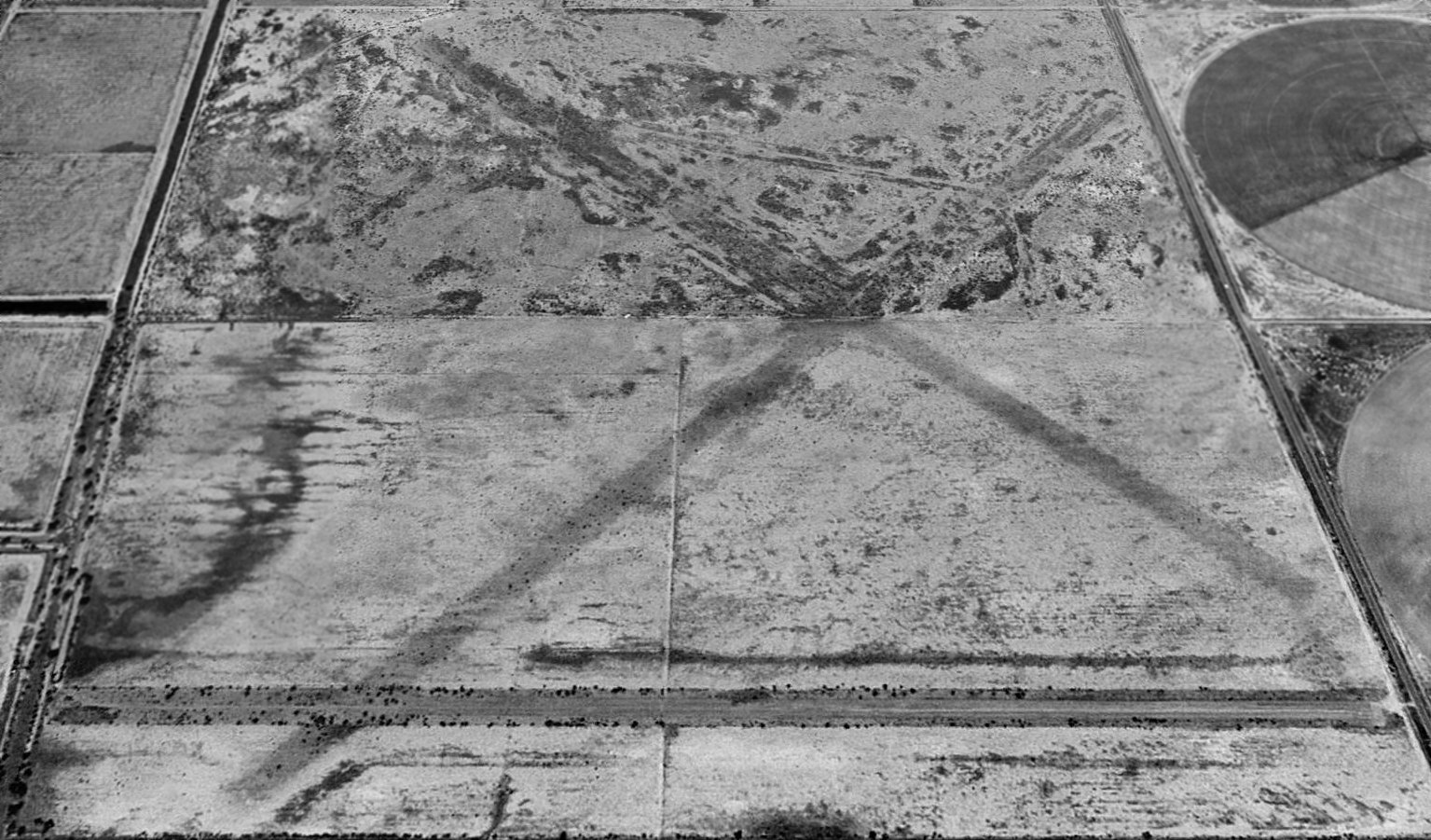
A 1996 USGS aerial view looking north at Webb Field showed the east/west runway to remain in better shape than the other 2 runways, which were noticeably more deteriorated.
There was no sign of any buildings.
Webb Field was not depicted at all (even as an abandoned airfield) on 2002 aeronautical charts.
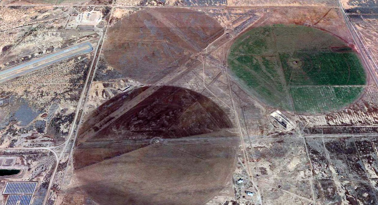
A 2014 photo by Mike Jamison, of “Elfrida Auxiliary's southern, east/west runway, looking west.
Photographed from the Route 191 shoulder, outside a locked gate.
Elfrida's in roughest shape, what with pivot irrigation now covering what looks like 70% of the old runway system.
At the site, only Elfrida's east/west strip offers any sort photographable evidence, and even that is hard to see.
Only by counting off exactly one odometer mile north from Rucker Ranch road could I definitely locate the strip.
U.S. Border Patrol agents also maintain a checkpoint at Rucker & [Route] 191, so you can guess how much fun I had running back & forth in my Jeep, to double-check mileage.
The Patrol was probably ready to provide a coffee cup with my name, by the time all was done.”
A 2016 aerial view looking north showed Webb Field remained in basically the same condition.

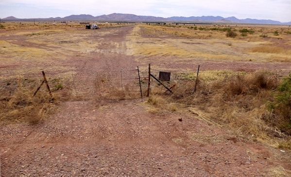
A February 2024 photo looking west along the former Webb Field east/west runway.
Webb Aux #3 is located northwest of the intersection of Route 191 & West Courtland Road.
____________________________________________________
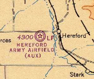
Douglas Auxiliary Army Airfield #5 / Hereford Field (01E), Hereford, AZ
31.418, -110.138 (SE of Tucson, AZ)
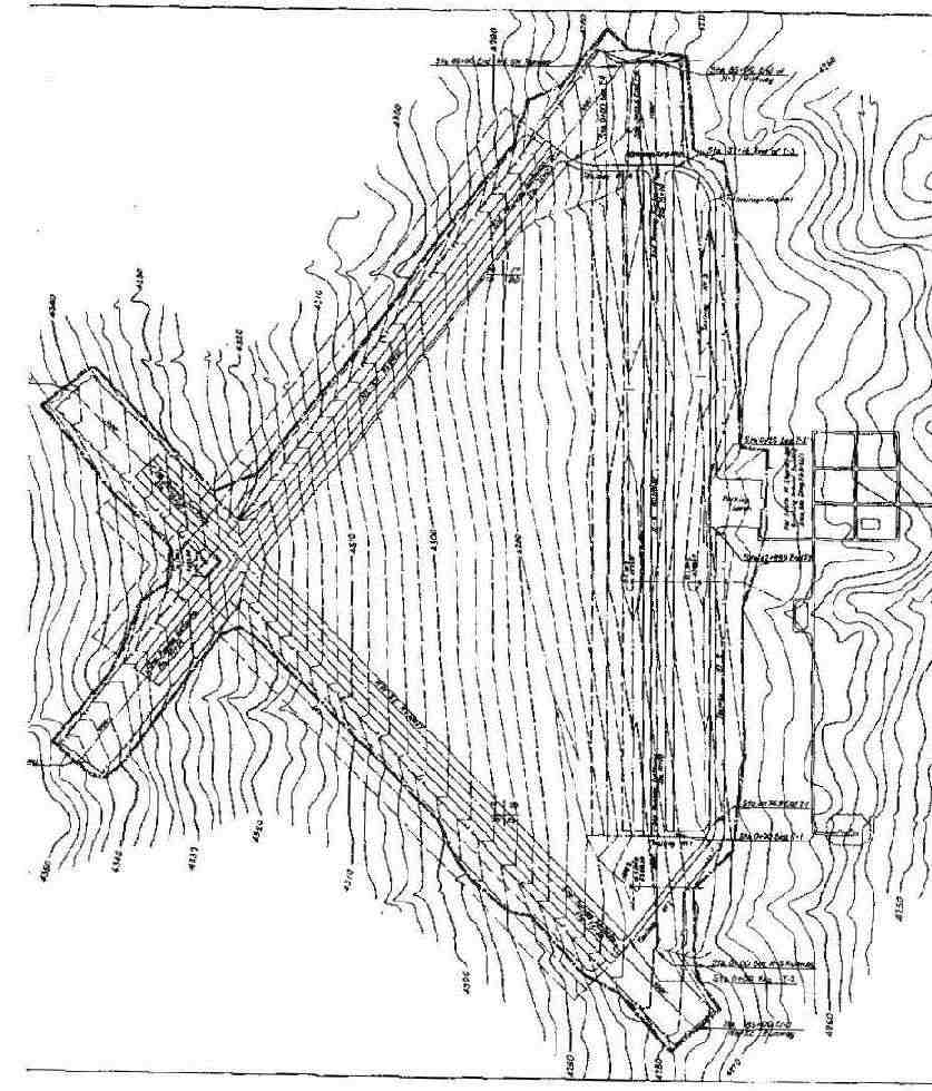
A September 1942 plan of the “Ground Air Command Support Base, Hereford” (courtesy of Ron Plante).
Photo of the airfield while operational has not been located.
Hereford Army Airfield was not yet depicted on the July 1941 Douglas Sectional Chart.
Hereford Army Airfield was established during WW as a one of 5 satellite airfields for Douglas AAF,
which offered specialized night training in B-25 & B-26 bombers.
A total of 2,598 acres were acquired by the War Department in 1942.
Improvements included 3 bituminous runways, 3 bituminous taxiways,
a concrete parking apron, 38 buildings, and 18 miscellaneous structures.
Due to its mission of training bomber crews, the longest runway at Hereford was 9,200’ long,
which was significantly larger than the typical runway of a WW2 era training field.
The earliest depiction which has been located of the Hereford airfield
was a September 1942 plan of the “Ground Air Command Support Base, Hereford” (courtesy of Ron Plante).
It depicted the field as having 3 paved runways.

The earliest aeronautical chart depiction which has been located of Hereford AAF was on the February 1943 Douglas Sectional Chart.
Hereford AAF was described by the 1944 US Army/Navy Directory of Airfields (courtesy of Ken Mercer)
as having a 7,000' hard-surface runway.
The last aeronautical chart depiction which has been located of Hereford AAF
was on the 1945 Douglas Sectional Chart (courtesy of Chris Kennedy).
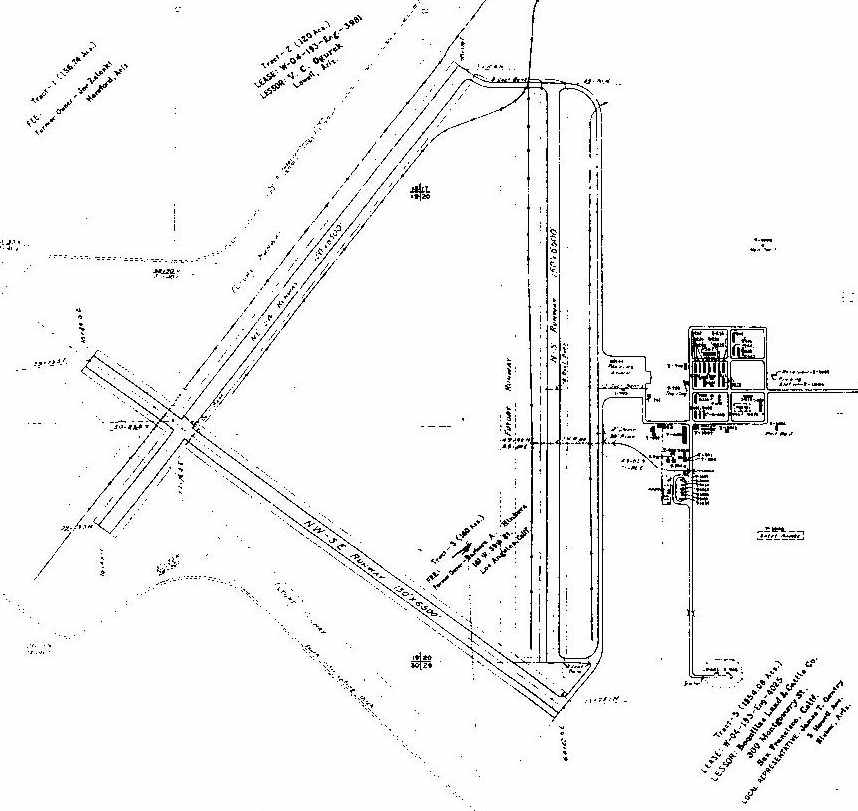
A 1945 plan of the “Douglas Army Air Field, Auxiliary Field #5, Hereford” (courtesy of Ron Plante).
Hereford AAF was declared surplus in 1945,
and custody was assumed by the War Assets Administration, which sold the property.
Hereford AAF was not depicted at all on the 1946 USGS topo map.
Hereford Aux AAF was still listed in a directory of AZ Airports in the 5/47 issue of Arizona Highways (courtesy of George Miller),
which described the longest runway as 6,500', but added the note, "Caution, some runways not usable."
Hereford was apparently abandoned by 1948,
as it was no longer depicted on the January 1948 Douglas Sectional Chart .
The 1955 USGS topo map depicted 3 paved runways, labeled “Airfield (abandoned)”.
The earliest photo which has been located of Hereford AAF was a 12/12/56 USGS aerial view.
It depicted the field as having 3 paved runways & the ramp area to the east of runways.
There were no hangars visible, but possibly one building remained standing to the southeast of the ramp.
It was labeled "Abandoned airport" on the 1966 Douglas Sectional Chart (according to Chris Kennedy).
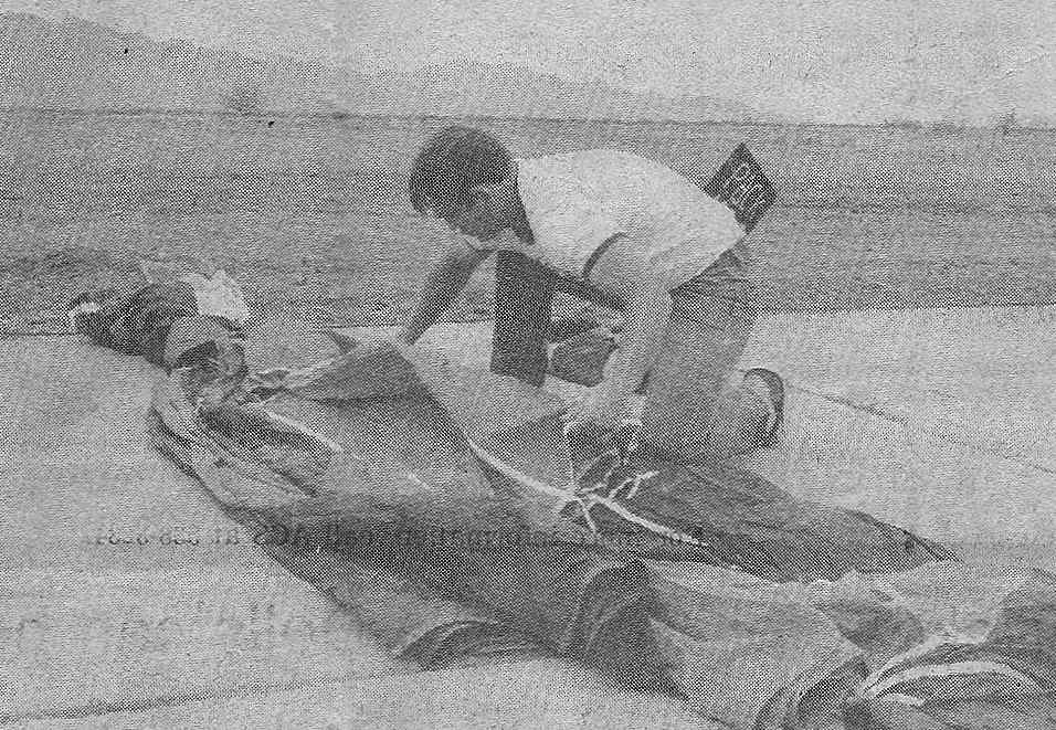
A circa 1976-77 photo (courtesy of Dusty Evers) showing packing of a parachute on the Hereford Airport cement apron,
with Huachuca Mountain visible in the background.
Dusty Evers recalled, “There was a private skydiving club that was ran out of Hereford during 1976-77.
Jim Morton, a retired Army paratrooper, owned it; the Golden Eagle Parachute Club.
The Club mainly was patronized by military folk from Ft. Huachuca.
However, it was also had a few from Tucson & Douglas College students.
The Club was short-lived as the owner’s wife was active duty & was transferred from Ft. Huachuca.
The airport ,at the time of the club, only used the North/South runway with the cement apron.
All of the other runways were had long decade beyond usable conditions.
The cement apron was where we packed our parachutes & served as a parking lot for vehicles.
There were only a few structures on the site and the club was operated out of a mobile trailer.
Even in 1977 the runway was short & in bad repair. We mainly used a Cessna 205 that was owned a private pilot.”
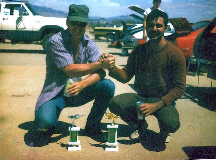
A circa 1976-77 photo (courtesy of Dusty Evers) of David Kutchinski & Perry Phipps
showing off their trophy for 1st & 2nd place in a weekend parachuting competition at Hereford Airport.
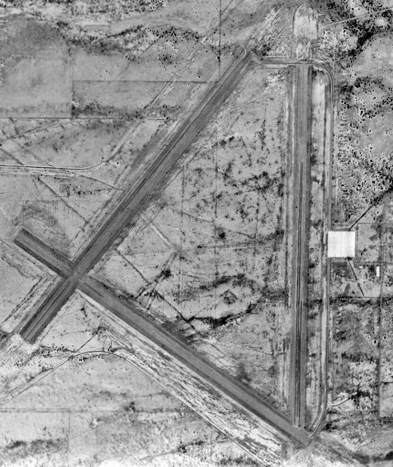
The only photo which has been located showing aircraft at Hereford Field was a 10/13/78 USGS aerial view.
It depicted 2 or 3 yellow single-engine aircraft parked on the east ramp.
Only the north/south runway was still in use; the other 2 runways were considerably more deteriorated.
No airfield at Hereford was listed in the 1980 Flight Guide (according to Jonathan Westerling).
Duncan Woods reported in 2014, “About 30-35 years ago [circa 1980], the old Hereford Airfield was in use
and whoever was occupying it appeared to have an aircraft dismantling operation going.
I saw a number of old military aircraft, including a couple of Grumman SA-16 Albatrosses.
It looked like there were quite a few aircraft there, all in various stages of disassembly.”
The Hereford airfield was apparently reused for some period of time as a civil airport,
as the 1983 USGS topo map labeled the site as "Hereford Airport", but only depicted the north/south runway.
The other 2 runways were not depicted at all.
Unfortunately this rejuvenation of the field was evidently short lived
as Hereford was not listed in the 1987 Flight Guide (according to Jonathan Westerling).
According to an Army Corps of Engineers report, one of the runways at Hereford was used by small private aircraft until about 1990.
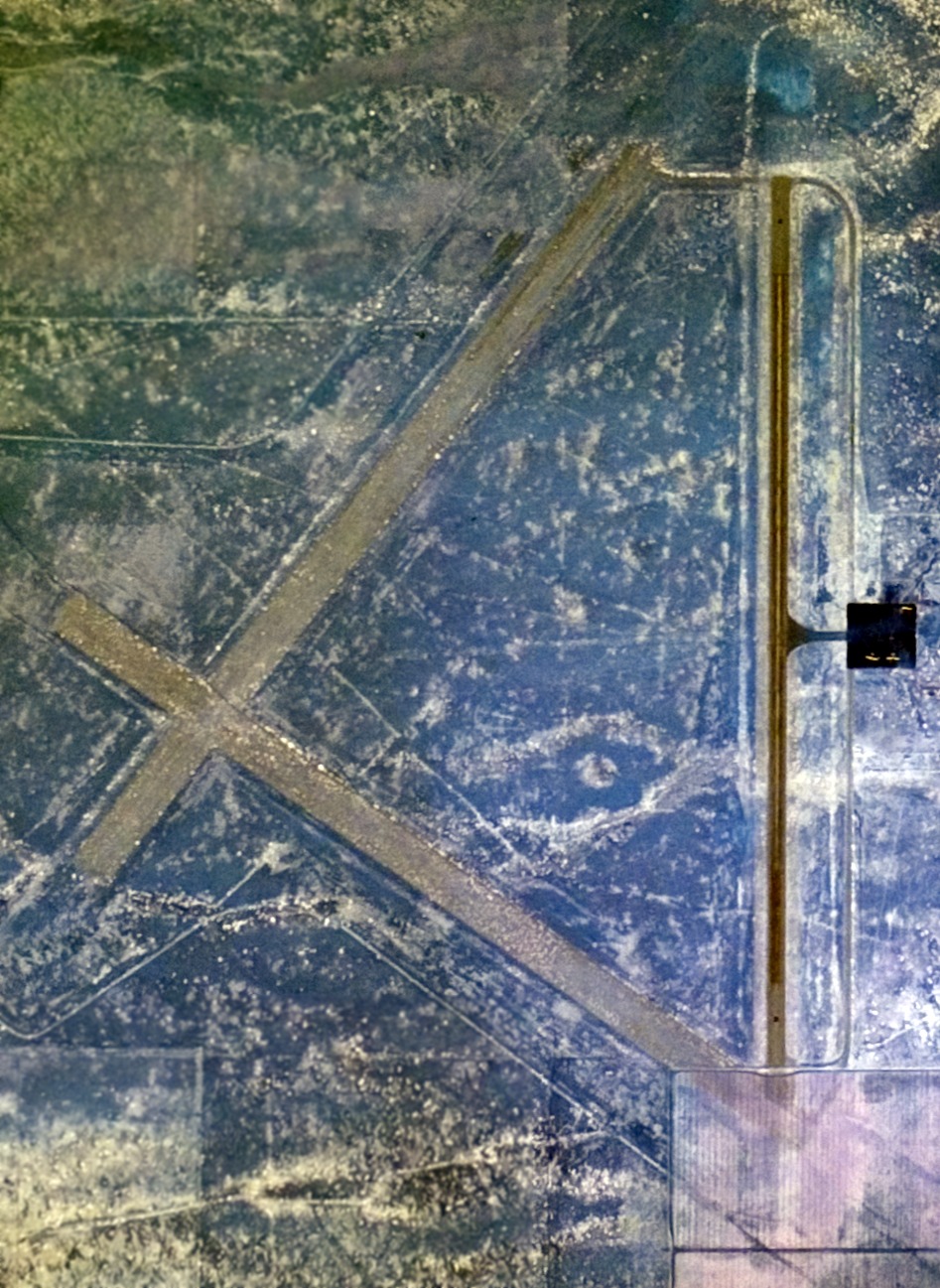
A 1992 USGS aerial view looking north at Hererford Field showed the remains of 3 runways & the ramp area to the east of runways was still barely perceptible.
As of the late 1990s, the entire Hereford site was privately owned.
The site has been used for a ranching operation that included removal
of almost all military improvements & planting of grasses.
The only evidence of DoD improvements remaining was the deteriorating concrete parking apron,
deteriorating bituminous runways & taxiway, and a pile of concrete tower bases.
As of 1998, the Hereford field was apparently abandoned again,
as it was depicted as an abandoned airfield on 1998 aeronautical charts.
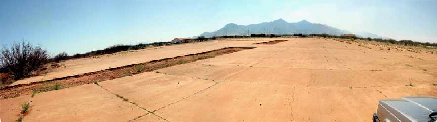
A 2005 composite photo by Jonathan Westerling “of the remains of the concrete apron at Hereford taken from the northeast corner.
The building visible on the far corner of the apron is a single-family house which uses the apron as its driveway.”
Jonathan Westerling visited the site of Hereford Aux AAF #5 in 2005, and reported:
“The land occupied by Hereford Auxiliary Army Airfield #5
has now become part of the suburbs of fast-growing Sierra Vista.
Plots have been subdivided, and several houses ranging from simple to elaborate
have been built on the site with many more to come.
Not that there was much left of the 1940s field, but its reuse as a civil airstrip (attempted in the mid 1980’s) would today be impossible.
The north/south runway has been graded & reused as 'Airstrip Road'.
One lucky family gets to use the old 500’ x 500’ concrete apron as their driveway!
It does not appear that the 1980’s redevelopment (as an airport) resulted in any improvements to the site
aside from a single prefab hangar & equipment shed which were erected on the apron.
From what one can tell, the landing facilities were limited to a 50' wide swath
of the overgrown bituminous runway & taxiways which were plowed to remove the weeds.”
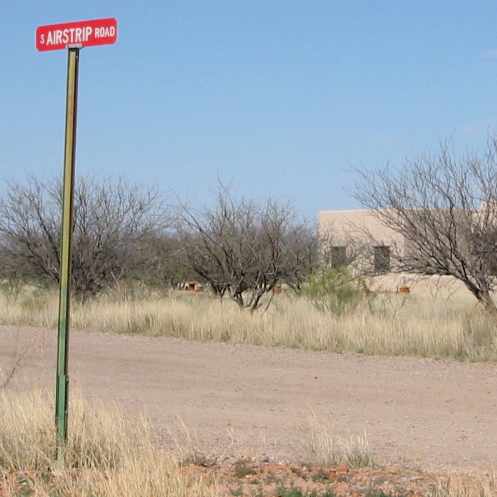
A 2005 photo by Jonathan Westerling of a street sign for “Airstrip Road”.
According to Jonathan, “The south end of the primary runway at Hereford Auxiliary Army Airfield #5
has been broken up & graded as 'Airstrip Road'.
Several houses such as the one in the background have been built along the old runway.”
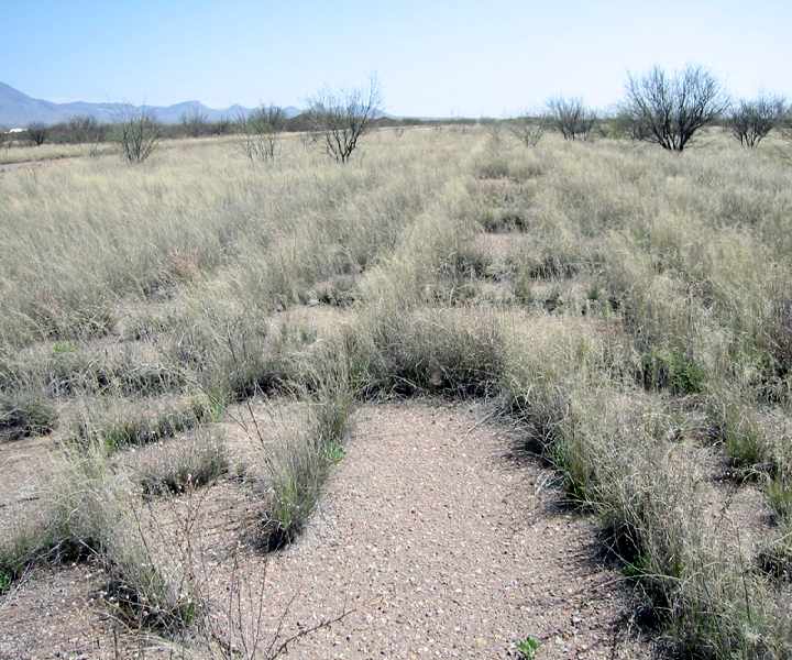
A 2005 photo by Jonathan Westerling, “Looking south along the primary runway at Hereford.
This section of runway has not yet been broken up to become roadway
and is likely representative of the conditions elsewhere at the field before the developers arrived.”
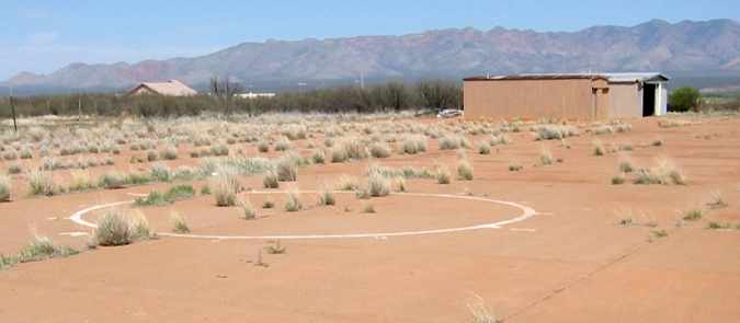
A 2005 photo by Jonathan Westerling of “the only remaining painted aviation marking at Hereford” -
a segmented circle “located in the middle of the north side of the apron”.
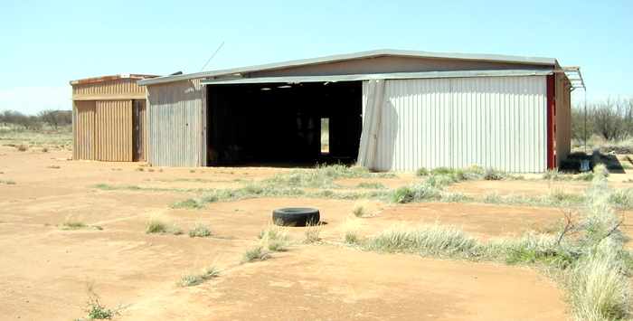
A 2005 photo by Jonathan Westerling. “This hangar & equipment shed are located at the northeast corner of the apron
and probably were part of the field’s redevelopment as an airport in the 1980s.”
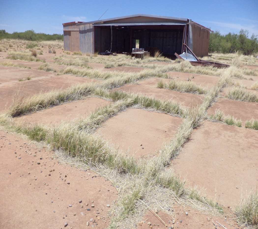
A May 2014 photo by Mike Jamison, of “Hereford's concrete-slab apron, with long grass growing in the cracks.
I don't know the metal buildings' purpose, nor do I know their age.
The easternmost runway at one time was used as a local airport but as you can see, activity ceased long ago.
The buildings may have serviced the airport, but again that is just a guess.”
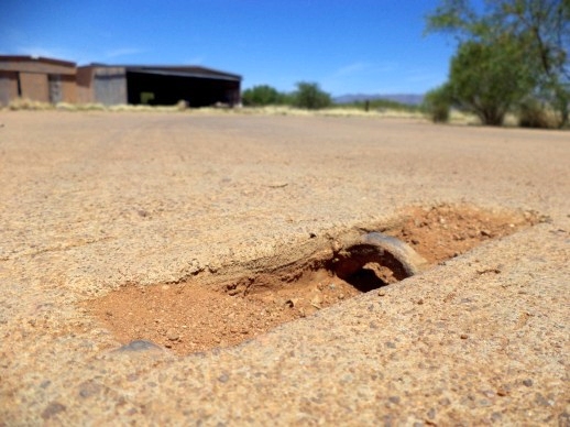
A May 2014 photo by Mike Jamison, of a “Hereford Apron tie-down cleat.
The apron's in great shape & still contains several rows of aircraft tie-down cleats.
The cleats are iron rings, set inside recessed grooves that one can photograph simply by opening a car door.”
A May 2014 photo by Mike Jamison, of “a section of Hereford AAF's easternmost runway.
The cracked asphalt runway pavement parallels a public, graded road.
Follow the cracked pavement on the pic's right half & you'll end up in a grassy area at top, which defines the old runway's continuing southward path.
The cracked & exposed runway asphalt, seen on the pic's lower half, lies within another dirt road that heads west.
Westbound traffic over time has laid the runway pavement bare, with grass pictured at top now covering runway areas that are located off the road grid.”
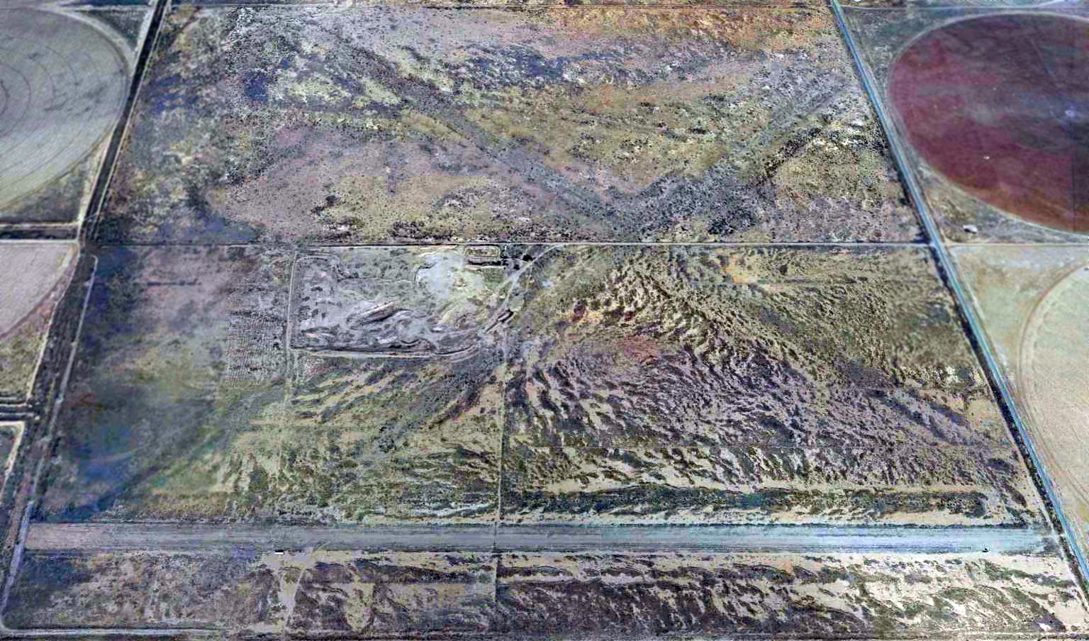
A 2015 aerial view looking north showed the former runways at Hereford are now sprinkled with houses.

A March 2023 photo looking northwest at the site of Hereford.
____________________________________________________
____________________________________________________
This site covers airfields in all 50 states.